1. Introduction
The City of Belfast in Northern Ireland (one of the four nations of the United Kingdom) has a varied history with regard to public, government, and academic perceptions of its public spaces [
1]. Marred by ethnic and religious divisions and civil conflict, Belfast’s form has been reshaped through formal infrastructure development and informal community-based partition from 1916 onwards. The result has been an evolving and multi-layered understanding of the landscape that illustrates extensive community interaction with specific locales, whilst perceiving other “public” spaces as exclusionary [
2]. The discussion of Belfast’s “natural landscape” framed as being socio-cultural or multi-functional is, however, under-represented in the research literature compared to considerations of the built environment. Moreover, when compared to parks, public spaces in residential areas have historically acted as interface zones—areas for community protest, depending on events and circumstances. Whilst residents and public/voluntary sector stakeholders now have responsibility for many such spaces, previously they were not managed locally (by the local authority or community groups), but by central government agencies and security forces including the British Army and the Police Service of Northern Ireland (PSNI replaced the Royal Ulster Constabulary in 2001). The management of conflict in such locations, through manipulations of urban form, has therefore shaped the narrative of Belfast’s urban development from the 1960s onwards [
3]. Post-1998—and the signing of the Belfast Agreement (hereafter the Good Friday Agreement)—Belfast City Council (BCC) and community advocates have engaged in discussions pertaining to the creation of “shared space” within green and open space development. To explore the successes of this process, the following examines the view that landscape, in its widest sense, and public parks specifically, can act as cross-cultural spaces that support all communities in a non-partisan way rather than being conceived as a barrier to integration.
In the context of Belfast, a “shared space” is one that is accessible to all communities but, importantly, does not dismiss the historical socio-cultural, legal, or political history of the city (or its spatial form) but aims to create a location where all people are welcome and find value in public space. Thus, the psychological and physical barriers that block use are addressed to ensure all spaces can be considered inclusionary—see Rallings [
4] for a more detailed discussion of shared spaces in Belfast.
Reviewed more broadly, Belfast exhibits a series of defensive architectural features that reinforce socio-cultural identities in specific communities. Peace walls, signifiers of territorial ownership, e.g., British and Irish flags, and built infrastructure such as the M1 Westlink motorway have all been employed to demarcate rights to the city [
5]. In turn, these artefacts have purposively re-sculpted spatial interactions based on religious and ethnic identities, shaping the city’s permeability. This process has supported a narrative of interiority in parts of the city [
6], which has been challenged post-Good Friday Agreement (GFA), and the subsequent development of the Belfast Agenda [
7,
8].
To explore the potential changes in perceptions of community boundaries, territory, and shared space, we examine the role of public parks within Belfast. Through an exploration of park use across Belfast, we examine attitudes toward these spaces adding to the established debates regarding the understandings of built/green infrastructure as exclusionary [
9]. Although the research does not explicitly ask participants to comment on the city’s history, parks have been presented in the literature as spaces holding less significant “identities”, thereby enabling cross-community patronage. This differs from normative assessments of Belfast’s urban space, moving the debate away from an inclusionary/exclusionary binary to examine whether public space can be reframed as meaningful shared spaces [
10]. Throughout, we do not propose to offer a systematic examination of all parks or their users, but a cross-cutting analysis based on engagement with patrons using high-profile parks across the city. To date, there is a more limited discussion of the role public parks play in local engagement within the literature focused on the city. We aim to add to this dialogue via the presentation of user responses from across the city—not from a single community—to illustrate complementarity and variation in how citizens of Belfast engage with the city and its parks.
Throughout the paper, parks are presented as public owned and managed spaces that are free to access for all. They comprise a variety of landscape types including formal parks, sports/recreational spaces, woodlands, waterways, and greenways, providing a suite of socio-cultural, economic, and ecological benefits to individuals, communities, and society [
11]. Parks are also presented as “shared”, not neutral locations of activity, as they retain possession of communal histories within their patronage. This is presented in the Belfast Agenda as a mechanism to develop identities connected with being a Belfast citizen rather than being Protestant or Catholic [
8]. Moreover, in areas where established cultural identities remain, these community attachments continue to shape the use of parks at local and district/city scales. Relationships therefore exist between the amenity value and the specific areas in which parks are located. However, we ultimately propose that Belfast’s parks could be considered to provide opportunities to act as shared spaces.
2. Framing Parks as Community Spaces
There are numerous examples of parks being used to facilitate community interaction. These include the promenading designs of Victorian parks in England [
12], the repurposing of formerly built infrastructure, e.g., railway lines, into linear parks in New York, Paris, and Miami [
13], or the formal uses of Chinese parks for group activities, including dancing or calisthenics, all of which have been planned to service the needs of their communities. In each of these examples, and within Tate’s [
11] exploration of city parks globally, we can see that the diversity of form, function, location, and scale are all discussed as supporting a diverse set of interactions with public space. We can also examine how park design, e.g., inclusive access, various heights/grades, diverse flora and fauna, and other public amenities, can be a direct reaction to the promotion of affordances for different users depending on age, gender, and ethnicity [
14,
15]. Consequently, we can identify academic literature debating the inclusion of a series of physical and socio-economic features used to facilitate positive perceptions of urban parks [
16,
17,
18,
19].
However, in cities where public space is subject to the complex interaction of socio-economic, spatial, or cultural/political factors, a more detailed analysis of the influences shaping use is required [
20]. In such scenarios, the provision of parks as a form of urban infrastructure may not lead directly to use [
21]. Consequently, discussions of accessibility and functionality need to look beyond provision as a key facilitator of use, and the subsequent development of personal or communal value. Discussions of quality are essential in this debate. Quality parks can be considered to provide amenities that are perceived as safe, diverse, and amenable to a broad range of social groups. Notwithstanding this, the provision of quality remains subjective with evidence arguing varying viewpoints on what high quality entails [
22].
Moreover, in many global cities, including Shanghai, Melbourne, and Berlin, there are additional political pressures placed on parks that cannot be mitigated by quality or amenity value alone. This is a prominent discourse where parks are considered locations of contestation between local communities, the state, or other institutions, for example, developers or corporations. Examples include the 606 greenway in Chicago [
21,
23], the Sabarmati Riverfront development in Ahmedabad in India [
24,
25], and Taksim Square in Istanbul—the site of protests against the Turkish government in 2013 [
26]. All highlight the ways in which parks are used to potentially challenge the rights of authoritative organisations to shape interaction and the rights of local communities to use a given resource. The power to manage access either formally via closures or the presence of security personnel or informally via tacit understandings of spatial affordances is central to this debate [
1]. It also raises conceptual questions about the presentation of parks as spaces of freedom and activity or as locations of observation and modified behaviour [
4,
10,
27]. The research of Leonard [
28] and Morrissey and Gaffikin [
29] in Belfast highlight the comparative nature of these issues via their analysis of the problems associated with community identity and demographic diversity, which are viewed as drivers of negative perceptions. The use of parks can thus become a political act supporting territorial/community control, dissent against external forces, e.g., the military or police, or control by the state over use. In many locations, the latter has led to communities being disenfranchised. It is within this space that parks in Belfast fall, as they have been subject to internal community and external political/security forces that have shaped use over an extended period.
3. Belfast’s Landscape and Planning
Planning in Belfast has been subject to significant socio-political changes over the last sixty years, leading to an idiosyncratic psychological and physical spatial form [
2]. This is visible in the spatial articulation of communities within ethnic enclaves in the city’s East, North, and West [
1], the use of defensive architecture to moderate interaction and engagement [
30], and the dual provision of public amenities across defined community boundaries (see
Figure 1). Ethnic and religious divisions date from 17th century Protestant plantations and the ongoing political legacy of the 1916 Easter Rising, which led to the segregation of communities, and subsequent mapping of built infrastructure along newly established socio-cultural lines [
31].
The most noticeable contemporary manifestations of this are the city’s “peace walls” and “peace lines”. First erected by the British military in 1969 following intense civil unrest, they were used to limit interactions and potential conflict between communities [
32]. From 1969 onwards, they were seen to symbolise community boundaries and territorial ownership, as well as the influence of the British state. Defensive architecture was used as a symbolic gesture by the UK government to exert continuing control over the city’s population and was discussed by Cunningham and Byrne [
33], who, along with Nagle [
34] argue that ongoing separation is estimated to cost the UK state approximately £1.5 billion per annum and raises questions regarding the political will to remove architecture if the financial implications of policing remain irresolvable. Moreover, over their lifespan, perceptions of the peace walls evolved from one of exclusion to adoption; a form of socio-cultural protection for their identity enabling communities to self-regulate the socio-cultural environment of their parts of the city [
32].
As visible signs of authority, these physical barriers are not the only infrastructure used to modify behaviour [
10]. The M1 Westlink motorway strategically dissects the city centre from North and West Belfast. Moreover, the location of “single community” health centres in the city has been viewed as internalising use and limiting inter-community engagement [
35]
1. As Deloitte and Touche [
36] (p. 6) noted, “the divide has also led to duplication or even multiplication of service delivery for the communities as they live side by side but do not integrate or share easily.”
Softer “invisible” barriers to interactivity are also present in East, North, and West Belfast. The “spoke” system of public transport, for example, means all services terminate in the city centre, limiting cross-city/community movement [
37]. These barriers to integration differ from the physicality of peace walls, but even areas that bear no visible demarcation of ownership are, however, known to be affiliated with specific communities [
38]. This reflects Lynch’s [
27] discussion of the creation and reinforcement of locations with specific social significance, thus influencing their legibility, with buildings, road intersections, and public amenities becoming territorialised. Across Belfast, examples of these softer boundaries exist, most noticeably between Protestant and Catholic communities in the city’s West [
1], as well as in specific sporting facilities in East and South Belfast [
9]. Historically, navigation of the city’s landscapes has been influenced by an awareness of social meanings, subtle changes in permeability, and the disposition of local communities to engage with spaces outside their perceived territorial “ownership” [
39].
Established narratives of urban division prominent in the academic and grey literature in Belfast evolved with the signing of the Good Friday Agreement. Post-1998, BCC has rethought the insularity of communities through the development of the Belfast Agenda [
7]. Within the agreement, BCC [
8] attempted to address planning for community-focused issues including housing provision (and associated movements of community boundaries), sports and educational facilities, and the potential impact this would have on the development of “shared space”. This strategy presented a bold vision for Belfast as a city with a shared history promoting shared use of public spaces [
7,
8]. The notion of “shared” rather than “neutral” space is critical, with “shared” implying retention of the city’s socio-cultural history, whereas neutrality downplays this to create places that do not reflect communal narratives [
40].
Resistance to this policy has been visible. Communities with established identities based on physical demarcations of territorial ownership and socio-cultural heritage have been less forthcoming to the notion of a shared Belfastian identity [
10]. This manifests itself in how communities regard the potential removal of the city’s peace walls and the proposed co-location and/or integration of public services [
38].
Figure 1 highlights the distribution of (a) predominately Catholic communities in darker grey and Protestant communities in lighter grey, (b) the location of the city’s “peace lines” that divide communities in red, and (c) the location and name of surveyed parks in green.
Figure 1 illustrates a predominance of Catholic communities in the west and south-west of Belfast and Protestant communities in east Belfast. Additionally, enclaves of Catholic and Protestant communities exist throughout the city and are located in areas with a more diverse demographic profile, e.g., south Belfast. Each of these features is discussed throughout the paper. The Super Output Areas (SOAs) are denoted in variated grey, and the surrounding areas are displayed in pink for contrast.
4. Conceptualising Parks in Belfast
Although Belfast parks range in size, location, and function, they have been largely absent from discussions of the city’s functionality, territorial ownership and sectarian conflict, or rights to the city [
1,
2,
10]. Although a minority, such as Ormeau Park, have been reported as illustrating variations in ownership due to growing Gaelic sports provision, the majority of public parks have remained outside of inclusion/exclusion discourses [
38]. Parks being considered neither as spaces of conflict nor as territorial “assets” that should be amalgamated into wider narratives of conflict can thus be viewed positively. This provides an opportunity to propose an alternative perspective that explicitly reflects a park’s location and functionality, as part of a wider network of spaces that people use, linking local, district, and city-scale sites. Such a perspective views specific sites as elements of both social and physical networks that transcend individual communities and allow people to engage with a wider range of parks [
10].
Assessments of Belfast’s landscape reflect the historical emphasis placed on understandings of community identities, and subsequent interactions with the “controlled” elements of the physical landscape. However, as changes in urban form, individual and communal interactions with the landscape, and planning policy occur, greater emphasis can be placed on parks’ functionality as barometers of social interaction [
9]. In many cities worldwide, parks are considered foci of community activities and can act as the physical “centre” of a community [
11,
41]. Within such discussions, the location, accessibility, and function of parks are fundamental to their use [
42]. Moreover, there are numerous examples of parks being contextualised as critical infrastructure promoting social interaction, inclusion, and meaning [
42].
Behavioural modification based on socio-demographic characteristics of the user, as well as the perceptions of others, has also been reported extensively in discussions of Belfast’s urban form, with research highlighting patterns of division that can be identified between user groups [
38]. Reported as being associated with formal access to amenities and informal adherence to communal norms regarding engagement between specific spaces, we argue that this reflects the links between observation and behavioural modification outlined by Foucault [
43] who argued that self-regulation occurred when fears of punishment were influential to individual uses of space. This is a common phenomenon across the world as user perception differs depending on the demographic composition of different groups. For example, when people feel watched they act differently and, as a consequence, the practice of control becomes self-fulfilling [
44].
Mell [
10] proffers that in Belfast, parks can be contextualised as extensions of Foucault’s behavioural modification and panoptical discourses. This argues that the architecture of a space provides privileged positions to some—noticeably authoritative—institutions, e.g., the police, who, via observation, can engender modified and potential negative behaviours in users. Mell implies that parks are inherently imbued with localised understandings of rights to space and hold agency via their ability to include or exclude people. Together with the physical location of a park, socio-cultural practices thus shape patronage [
45]. This can be moderated internally by communal acknowledgements of inclusion/exclusion to facilitate an informal approval of “acceptable behaviour” or via more formal structures such as access points, fences, parking, and opening hours. Observation holds a key role in this process. Being observed, and being the observer, have been shown to significantly influence how people use spaces and who is perceived as “acceptable” therein [
46]. This raises questions regarding the meanings placed on parks and asks whether parks can act as key components of how people navigate Belfast’s infrastructure if they feel observed or “other” in a specific location. Such an argument is reinforced by Lee [
47] (p. 524) who discussed the notion of Belfast as a neutral city zoned into quarters each imbued with historical or socio-economic meaning “…to symbolise multiplicity, inclusivity and neutrality…[but] run[ning] the risk of contributing to social polarisation… rather than providing a space people from all backgrounds can enjoy”. These notions form the basis of the analysis presented in the following sections.
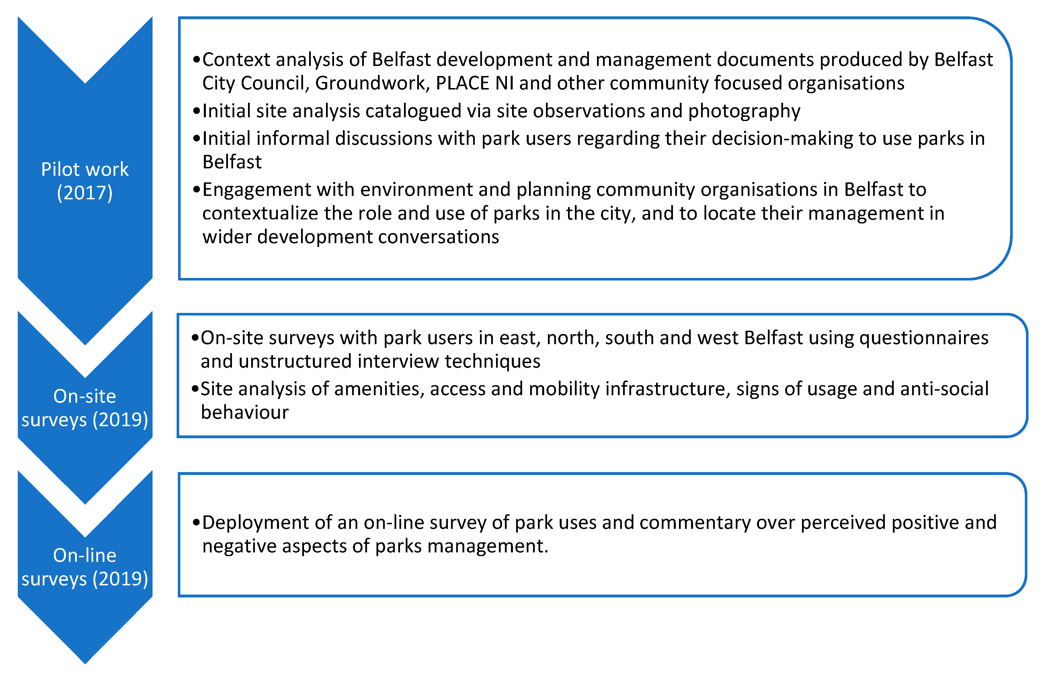
5. Methodology
To investigate the role of parks in Belfast, a multi-method approach (see
Figure 2) was used to assess how communities interact and perceive their value. Conducted over an extended period (2017–2019), data collection provided insights into the factors influencing park use in different parts of the city. This was facilitated through on-site observations, the scheduling of a consultation event, and face-to-face surveys complemented with an online survey. Data collection was structured into three phases: (a) scoping, (b) on-site data collection, and (c) the online survey. Each phase generated a detailed assessment of how different communities “viewed” Belfast’s parks, interacted with, and found value in them. Responses subsequently provided signposts to discuss issues of identity and the factors promoting and barriers restricting use.
Due to the complexity of territorial and communal politics in Belfast (see Mell [
10] and Murtagh [
48] for a more detailed commentary), the use of a range of techniques, employed over an extended period, was considered essential to ensure engagement. The project worked closely with community and governance groups in Belfast during the scoping stage to integrate representations from across the city’s communities to ensure localised perspectives, opinions, and behaviours were included in the research materials. This was an extensive process undertaken via several visits to Belfast to engage stakeholders and aimed at ensuring the focus, language, and line of questioning were contextually appropriate. One outcome of this process was the selection of a spatially diverse set of research sites made in conjunction with local stakeholder knowledge. The chosen sites were subsequently surveyed (see
Figure 1). This facilitated an engagement with a more diverse sample drawn from the established communities of East, North, and West Belfast, as well as those considered more transient in the city’s south [
29]. It is acknowledged that the number of responses received (N: 178) across the three stages of data collection limits the scope of the project’s findings. However, the breadth of qualitative data generated from the seven sites surveyed and those received via the online survey provided additional depth to support the project’s analysis. Where respondents engaged with surveys, they provided detailed answers that linked the wider political, socio-cultural, and physical issues discussed in the research literature to their own use of parks. The level of detail obtained from the face-to-face survey thus provides the paper with a qualitative depth and grounds the following commentary by linking the research literature with respondent uses. We also acknowledge that the total number of respondents engaged is not representative of the wider population of Belfast, and that a greater (and/or proportional) sample is needed to facilitate a generalisable outcome. Unfortunately, the project was subject to time constraints placed on fieldwork, which limited the time spent on site and, subsequently, the number of responses generated. The data collected are considered robust due to the three phases of data collection undertaken, with the scoping process being particularly useful in framing the data collection process.
5.1. Phase 1a—Pilot Engagement with Planning and Community Representatives
To contextualise the role of parks, a process of engagement with local planning, community, and parks representatives was undertaken to better understand the complexities of urban development and environmental/park management in Belfast. Pre-project scoping discussions with community-environmental organisations, academics located within Belfast, and the City Council were held to debate Belfast’s changing demographic nature, and the role of urban regeneration and socio-cultural policy-making in influencing the use of the city’s landscape. A total of 9 representatives from 6 organisations were engaged. Through this process, the project integrated nuanced appreciations of communal structures, approaches to engagement known to be effective, and an acknowledgement of local barriers to park use that might otherwise have been excluded. The planning stages were crucial in identifying potential sites for investigation, as local stakeholders were able to identify locations where parks were subject to a variety of perceptions focused on territory, identity, and different user groups. It was also possible during this process to consider the terminology used in surveying materials to ensure that contentious language or themes were removed, and that the focus of discussion remained on parks and the use of these spaces.
5.2. Phase 1b—Pilot Survey
A pilot survey was conducted over five days in June 2017 generating 101 responses from 7 sites (see
Table 1). Respondents were asked about their use of parks including how often and where they visited, what activities they undertook in parks, and what value they placed on them within their communities. The questions were influenced by discussions with local stakeholders in
Phase 1a to ensure that the appropriate terminology and framing of questions were used. Participants reported their use of a suite of parks and were asked to consider relationships between location, proximity, functionality, and socio-cultural reasons for use. Sites were chosen following consultation with local government, planning, and community groups during the scoping stage. Sites within Belfast were selected, rather than urban-fringe or country parks locations, as they are considered more accessible and to be a more focal part of the fabric of specific communities.
5.3. Phase 2—Parks Survey and Public Consultation
A structured 10-question survey was developed and used to generate responses based on the following lines of questioning. Respondents were asked to consider (a) their use of a suite of parks, who they used them with, and how often they visited, (b) to identity which park or parks they used and which were closest to their home, (c) the rationale for use, for example, distance from home or amenities, (d) whether the provision of specific activities/amenities promoted use, and (e) and whether they considered the parks they used to be part of their community. Questions focused on "community” also asked whether they considered parks to be accessible and used by all residents or provided for those living proximate to specific sites. The lines of questioning reflect the core themes outlined in the literature examining why people use parks and what they use them for, and take into account form, function, and location as key characteristics of use [
11,
14,
18,
29,
38].
On-site surveys were undertaken in September-October 2019 in the Falls Road, Victoria, and Ormeau Parks and the Botanic Gardens to generate responses from users as to why they used parks (see
Table 1). Surveys were conducted at different times throughout the sampling days to help generate a more diverse set of responses rather than a homogenous one constituted of dog walkers or older people (both common park users). A consequence of this process was that the number of responses was variable across each site. Time constraints also restricted repeat visits to Waterworks and Alexandra Parks in the north of the city, limiting the triangulation of responses from the pilot survey with other parts of the city. In total, 38 participants were surveyed at these four sites providing additional contextual information related to Belfast’s parks. A further public consultation event was held in the Botanic Gardens in October 2019 providing an opportunity for the public to engage with the project. The event included opportunities to complete the 10-question survey and discuss issues related to parks with members of the project team. The event was poorly attended, with 12 attendees facilitating 3 formal responses. The lack of engagement was due to scheduling limitations; however, the discussions held with attendees were detailed, providing insightful commentary on the value of parks for people living in south Belfast.
5.4. Phase 3—Online Parks Survey (January–November 2019)
To complement the face-to-face survey, an online survey was developed. Structured to mirror the face-to-face survey, the 10-question survey captured responses from park users who might not have been on-site during fieldwork site visits. The survey was publicised via social media and local community/planning networks. The survey was available to complete over a 9-month period. Despite this extended timeframe, only a small proportion of people completed the full survey: 27 in total, although 913 engaged with and/or started the survey. The number of respondents surveyed was small due to an ongoing mistrust of providing informed written consent. It was reported to the project team by local environmental organisations that Belfast residents were reluctant to provide their name, personal details, or consent due to ongoing social influences and stigma associated with The Troubles and engagement with formal and/or non-community-led consultation activities. Consequently, a significant proportion of potential respondents withdrew from the study when asked to sign the consent forms, despite having previously agreed to participate.
The following sections, however, draw on direct commentary from respondents to the online and in-person surveys. Each comment has been anonymised except for the location where the survey took place. Anonymity has been retained to provide a more nuanced understanding of how park users perceive specific locations. No personally identifiable information was requested in the on-site or online survey (except for the signing of consent forms—see above), and no personal data were subsequently used in the paper, ensuring anonymity was maintained. The process of confidentiality was explained to all respondents who participated in the survey. Consent to use the responses of park users was obtained at the point of data collection and all participants were provided with details of (a) how to continue to engage with the project, (b) contact details for the project coordinator, and (c) their rights to withdraw their responses at any time.
Additionally, the project had to address the positionality of a research team being from “outside” Belfast, and specifically from outside the communities being surveyed. This was addressed via extensive engagement with local practitioners, the city, and the environmental/third sector to help structure lines of questioning and select appropriate methods to conduct primary data collection. The aims of the study were outlined clearly in all literature/material produced to support the project. However, we acknowledge that respondents may have answered differently due to our lack of a localised identity; consequently, we may not have been given the “full story”. We also acknowledge that, although we were focused on parks, that the wider context of the use of space in Belfast related to civil unrest may have arisen or been expected from participant responses. As a result, we worked extensively to triangulate findings and situate the project’s findings in wider academic and practitioner debates.
6. Results—Rethinking Parks as “Shared” Spaces
The data collected illustrate a variety of socio-cultural understandings of parks, their value as community spaces, and the multiple uses they have in Belfast. The range of responses received suggests that a continuum exists in the perception of respondents influencing engagement with parks across Belfast. This takes into consideration historical communities and, by extension, parks’ contexts, facilities, and the activities undertaken at each site. From this analysis, we identify a suite of meanings attributed to parks across the city.
The respondent commentary was analysed through a number of thematic framings. These criteria mirrored the themes presented in the literature as promoting interactions with the physical environment and focused on the location and amenities of a site, the composition of specific communities and their engagement with parks, how these interactions are shaped by historical narratives, and the ways in which visible and invisible signifiers of territorial ownership shape use. Each of these was a prominent theme in responses providing a set of diverse representations of parks in Belfast. There is also a synergistic relationship between these areas that reflect a collective appreciation of the ongoing complexity of parks as shared spaces.
6.1. Location & Amenities
Parks’ locations were reported as being critical to usage. Proximity was key for many respondents who considered “the park [as] the only garden we have” (Falls Road respondent). This view was repeated across West Belfast, an area where many homes have small or no gardens, and supports the perception of parks as extensions of people’s living space. Moreover, it was reported that aesthetic quality, perceived safety, and amenities influenced the decision to use, as one member of the public stated in Victoria Park:
“there’s more going on. Its better now, more things happening. Its more mixed now; everyone speaks to each other.”
Within such decision-making, activities including parkrun, GAA sports, and informal engagement with games of soccer were all discussed. It also reflects the provision of “special events” such as the Communities Festival Féile an Phobail in Falls Road Park held on public holidays. As one user of Ormeau Park noted:
“Although people live closer to other sites, i.e., Cherryvale Park, Ormeau Park is a destination site for the area.”
Moreover, the growing use of parks for sports, community activities, and informal social gatherings, such as dog walking and friendship, were discussed in Victoria and Alexandra Parks as positive attributes, as people could come together without encountering the same level of perceived cross-community observation. Respondents considered parks to provide a physical location that could be used to facilitate activities. As noted by users of Ormeau and Falls Parks:
“Parks bring people together and act as hubs for various groups (gender, ethnicity, or special needs). [It] also brings in people from local offices/places of work, as well as local residents and students.”
(Ormeau Park respondent)
“Lots of alternative uses and values attached to the park although these vary due to the people who use it (youth causing problems) and changes due to increase in sports facilities; events bring people in, although this is a Catholic area all are welcome; non-aligned [i.e., migrant/ethnic] communities come here as they aren’t part of the history of separation.”
(Falls Road Park respondent)
6.2. Specific Communities and Barriers to Interaction
The comment from the Falls Road Park above also illustrates the ongoing complexity of promoting cross-community uses of space, where there is a residual mistrust of other parts of a city’s population. This was particularly prominent in parts of West and North Belfast where visible reminders of cultural identity attached to place, e.g., peace walls, remain. This was highlighted by three participants who noted:
“You can always tell people’s religion because it’s connected to the area where they live, so if you see someone leaving a certain gate you know where they live and what religion they are. One gate in this park is the Protestant exit, another is the Catholic’s; the third gate face a new housing estate, so its mixed. The Botanic Gardens are more neutral because of the people who go there, and so is the South of Belfast. The North has pockets of neutrality. More mixed areas tend to be more middle class because people actually choose to live there and can afford to choose. Here is like a silo, more contained.”
(Alexandra Park respondent)
“Park users do stick to their “side” or area in terms of park use–they don’t always venture across visible/invisible boundaries.”
(Waterworks Park respondent)
“I wouldn’t go to a park in a Protestant area because if someone asked my name, they would know I’m Catholic, so I don’t think green spaces are [more] neutral. You can’t just chit-chat if you go to a park in a Protestant area.”
(Falls Park respondent)
Each of these comments highlights the interplay of location, socio-cultural identity, and residual fear leading to self-exclusion from a park. They also highlight spatial variations in this process, as only respondents from North and West Belfast reported feeling alienated from parks due to their religion. Moreover, a respondent in Alexandra Park (located in North Belfast) proposed that other sites, for example, those in Central and South Belfast, are not subject to the same level of perceived exclusion. Consequently, respondents noted that although Belfast is moving towards a shared identity, via the Belfast Agenda, communities continue to self-regulate interactions due to a perceived or real fear of being challenged when using specific locations. Demographic composition and, by association, community tenure, were also reported as being related to the varied use of shared spaces. The Alexandra Park respondent, for example, noted that areas perceived to be middle-class were more mixed with less visible signs of communal separation. Ormeau Park in South Belfast was noted as being inclusive for a greater range of people as:
“you’ll see minorities coming together…along with a variety of people using the park for [different] activities.”
This suggests that although established socio-cultural divisions remain significant in how people engage with parks, an additional characteristic of use may, however, relate to class and/or ethnicity and has implications for the strategic objectives of BCC going forward.
6.3. Current vs. Historical Appreciation of Parks
Communities’ formal and informal separation from parks was also reported as being linked to ongoing engagement with narratives of “The Troubles”, and how these shape communal identities. A significant proportion of park users noted that, historically, parks were viewed as community amenities that were welcoming for all. However, during periods of civil unrest, they became locations of socio-cultural tensions where teenagers/youths congregated to engage in acts of violence (see also O’Dowd and McKnight [
31]). Thus, parks transitioned from safe spaces to exclusionary zones for some residents, although the timings of such activities were restricted to weekends, public holidays, and after dark. Historic anti-social behaviour was the most commonly reported limitation of people’s use of parks. Currently, anti-social behaviour has shifted from antagonism and violence to drinking and drug use, which decreases use, especially in the Falls Road and Waterworks Parks. One respondent in the latter noted that although a perception remains that parks are generally safe, The Troubles’ legacy means that some areas are ‘off limits’, as they continue to host anti-social behaviour. Such perceptions, they suggested, were informed by growing up in Belfast and the restrictions this placed on individuals. As a result, people may feel uncomfortable engaging in unfamiliar spaces. A Falls Road Park respondent took this further, stating:
“We don’t go far in Belfast…[the] Falls Park acts as a hub that connects five Catholic/Republican communities in West Belfast; it promotes use and [continuity of] use, as seeing the same people over an extended period.”
The underlying sentiment this comment provides offers insights into the role of self-regulation expressed by some parts of the city’s population. They identify parks’ value in bringing people together but acknowledge specific sites’ that simultaneously limit use due to fears of interaction with “other” communities. This is a key variable in how some choose to engage with parks, reinforcing existing socio-cultural perceptions of their rights to specific parts of Belfast, whilst excluding others for fear of observation. Such complexity in terms of affordances is visible in the ways in which respondents discussed the interplay of the physical environment with ongoing socio-cultural markers of community.
6.4. Visible and Invisible Determinants of Use
One of the most frequently discussed issues regarding use was the ways in which people navigate visible and invisible barriers. Several Alexandra Park respondents noted that the peace wall was seen as a physical manifestation of continuing tensions regarding the use of that space. Some felt that: “Walls like that cause division” and are “…a barrier, and if they leave it like this, the country will never move on”, whereas others supported the tenure of defensive architecture stating that “…it might make people feel insecure without the wall”. Consequently, we argue that no unified perception of defensive architecture or its influence on usage exists, which makes community interaction difficult to plan for. Other respondents, however, argued that parks can be seen as separate from these discussions:
“People come together despite you know? Divisions. That’s a good way of putting it”
(respondent in the Waterworks Park)
Contestations do, however, remain between which parks and what activities people believe they can engage with. This view is visible across Belfast, as participants in all sites expressed similar concerns, although the frequency of their reporting was greater in the city’s West and North. For example, a user of Ormeau Park stated:
“People understand which side is allowed to use specific areas of the park; less mixing with adults but kids and dogs lead to greater interaction.”
Abdelmonem and McWhinney [
38] highlighted comparable findings in Ormeau Park using sports, and specifically, engagement with GAA sports, as indicators of visible and invisible signs of engagement. Moreover, across Belfast tensions are reported in how respondents viewed the growing event/commercialisation of parks and their use for structured sports as challenging some communities’ rights to use. However, the analysis presented here suggests that this was aligned with older respondents not wishing to see changes in physical infrastructure, rather than reinforcing religiously grounded division. Finally, a user of East Belfast’s Victoria Park provided an insightful reading of the physical, political, and socio-cultural landscape:
“…there is sectarian housing in Belfast but no sectarian parks.”
Interpretations of this nature are critical to understanding the value of place in Belfast, as they place parks outside established narratives of exclusion. Although not all respondents agreed with this statement, there is sufficient commentary proposing an aligned, yet alternative, conceptualisation of parks within Belfast. For some, parks remain part of the established narrative of communal ownership and self-regulation, whilst for others, they provide opportunities to engage in new activities, meet new people, and engage more extensively with the city. Moreover, there is an appreciation of how demographics, class, and the changing nature of the city’s landscape influences use across and between communities. As BCC strives to deliver the Belfast agenda, this suggests that entrenched views on segregation can be challenged.
6.5. Users, Location and Amenities
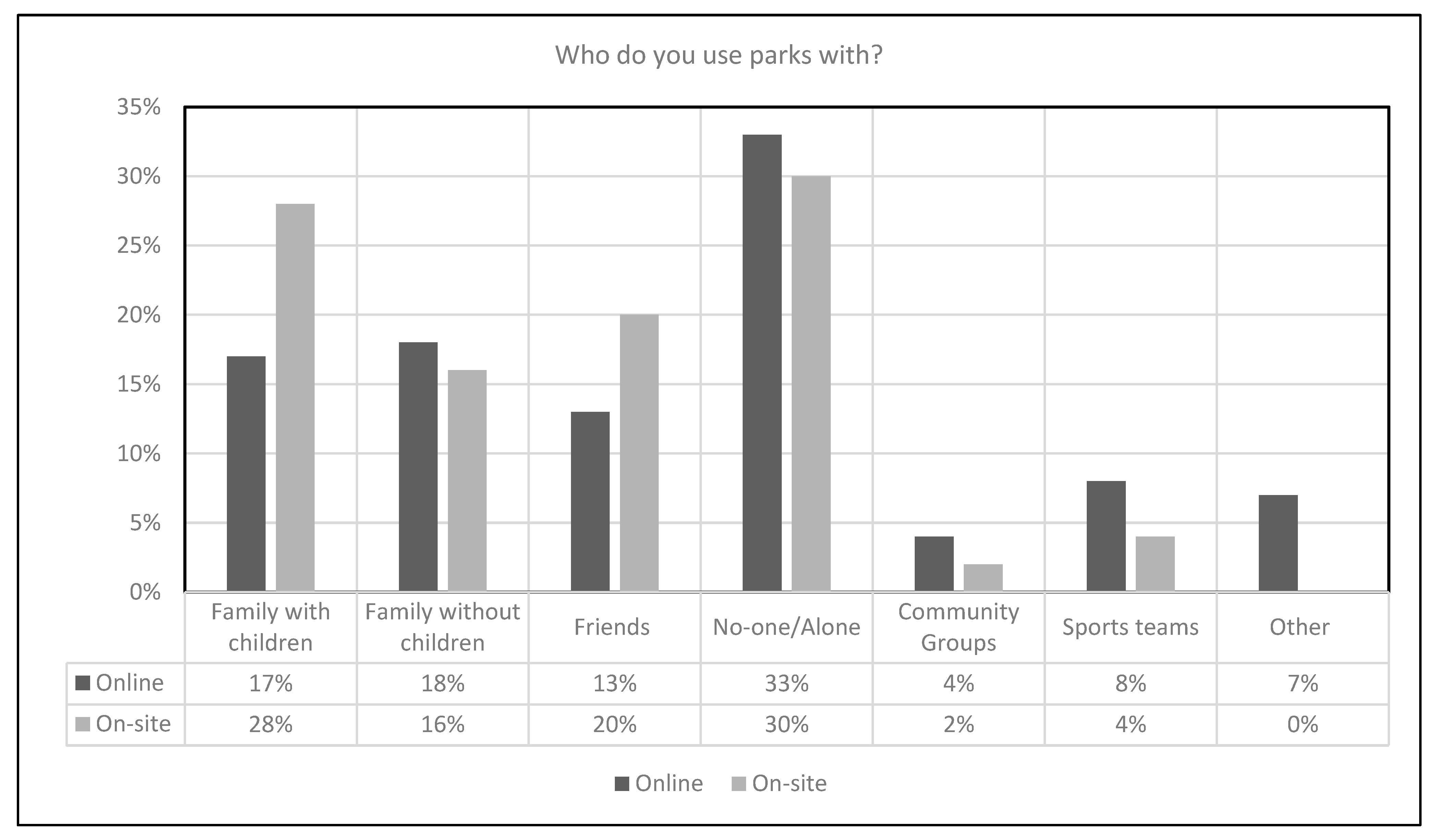
Who participants used parks with was also an important point of discussion.
Figure 3 shows that a significant proportion of users engaged with the city’s parks with their families or friends (48% of online respondents and 64% of onsite). This, we argue, raises the profile of parks as community or shared spaces, as they are being used to facilitate communal activities. It also suggests that Belfast’s parks may be more aligned with international assessments of parks as communal centres of social, sporting, and health and well-being activity (see also [
11,
34]). However, the data highlight that over 30% of site respondents used parks alone. This is more attuned to UK research, which comments on park use being a predominantly solitary affair [
49].
The selection of which sites to use, and whom parks are perceived to be for, provide an additional lense through which to assess Belfast’s parks as communal spaces. The majority of respondents only used sites within a 20-min walk
2 from their homes. For the on-site results, this figure was 54%, whilst online, there was an equal split (of 39%) between people using local (less than 5 mins walk) and community/neighbourhood parks (5–20 mins walk) (see
Figure 4). When read against the thematic analysis presented above, we propose that a significant proportion of respondents used parks (a) that they are familiar with, (b) are located within a specific and/or geographically defined community, and (c) of which perceptions are shaped (in many cases) by remnants of the city’s historical divisions. Interestingly, several respondents also stated that they also used ‘destination’ parks. This, however, was presented as an exception and was to undertake specific social, sporting, or nature-based activities, not catered for in their local parks.
A further aspect of the analysis was whether parks were part of local communities, and who had the right to use or access them. There was unanimous acceptance (86% (online) and 91% (on-site)) that parks were part of the local community’s physical and social infrastructure. Moreover, parks were seen as resources for all members of society (88% and 90% online/on-site) with only 4% of online respondents arguing that Belfast’s parks should be for specific communities. We therefore argue that although people may use local sites more frequently, there are fewer socio-cultural barriers to their use by wider cross-sections of society.
This analysis is supported by the commentary discussing the value of parks to both individuals and the wider community. One online response stated that [parks are] “fundamental to life”. This view was extended by several online respondents who contextualised their appreciation of parks as follows:
“…the parks link several communities. I would like my community to be drawn to the park for the sake of improving physical and mental health and well-being.”
“…like an extension of their own gardens for many local residents.’ & ‘…especially since a lot of houses don’t have gardens.”
“In my community it feels like they are. I can see people from all ages, families, groups of friends, older adults, kids, athletic people, people from other countries, students, sometimes tourists. Most of the time people say ‘hi’ to you even if they don’t know you. This gives me a sense of community and I certainly feel safe and content when I am at the park/green space. It is always a good chance to meet someone new–so yes, I feel they are well embedded in the community where I live.”
These comments articulate several key factors identified within the literature as influencing use, namely, location, parks as an extension of people’s gardens, and parks as potential mediators between different communities [
42,
50]. Each of these aspects promotes the sense of community that comes with engagement, and the various activities undertaken in parks. Moreover, commentary highlights the value of social interaction as a key variable in why people value parks. Participants also noted that parks are free to use and therefore do not have the economic barriers that some people may experience when accessing other sites.
Two further comments illustrated why parks may be of specific importance to communities. First, one respondent from Falls Road Park noted that “of course—to not come would mean missing something; [its] our own place.” This suggests that there are explicit links between amenities and socio-cultural values in using parks, especially in terms of promoting personal and communal health and well-being. Second, a further Falls Road Park respondent stated that Belfastians are historically predisposed to engage locally in certain parts of the city, promoting the use of specific subsets of parks, due to legacies of community attachment and city-wide spatial divisions. This, they stated, was linked to sites being part of more localised and familiar networks of places. Other parks were used less frequently in part because of proximity but also due to transport restrictions, and ongoing fears that they would be identified as outsiders, and not be welcome.
Figure 5 shows an approximation of the self-regulation described by respondents in their commentary regarding the use of parks. The yellow lines are “zones” where people suggested they would be willing to travel to use parks in addition to their local park. This potentially illustrates that people in specific areas of Belfast (a) regulate the distance they travel to access parks and/or their amenities and (b) that many respondents were only willing to travel to places they consider to be within their local community. For example, people using the Falls Road Park would be less willing to travel to parks in north or east Belfast. Likewise, users of Victoria Park in east Belfast may be less inclined to use parks in the west/south-west of the city. Within respondent commentary, such self-regulation was related to considerations of sense of place, feeling welcome in different locations, and the familiarity of an individual with the parks in a specific location. The same colour scheme as in
Figure 1 is used.
7. The Future of Parks in a Divided City
Perceptions of parks, and their socio-cultural function, vary significantly across Belfast. However, there is an overarching view that parks act as critical community resources, and that they are locations open to all irrespective of demographic or communal attachments. Such a conclusion provides a forward-looking analysis that aligns directly with BCC proposals to ensure that Belfast’s landscape “…deliver[s] an integrated plan to improve good relations, develop a sustainable, transferable and scalable approach to management and promotion of shared spaces…” [
8] (p. 32). This statement requires a caveat reflecting the ongoing contestations visible in Belfast focusing on communal attachment to place, relationships between specific locations, historical segregation, and growing challenges to the rigidity of territorial ownership within parts of the city as discussed extensively by Shirlow and Murtagh [
9]. A lack of policy development or funding from the Northern Ireland Executive due to Stormont’s three-year closure
3 may also have been a factor—but was not explored by respondents. Discussion continues to be framed by a fluid engagement by communities and planners with established inclusion/exclusion narratives. In part, this reflects the city’s diversifying demographic structure and changing appreciation of the role that segregation holds over people’s lives. Huck et al. [
51] examined comparable factors from a quantitative perspective noting variation in the type of resources that remain segregated, e.g., local corner shops, compared to other spatially larger or distant amenities. A perceptual continuum may therefore exist within park users’ understanding of infrastructure and its role in reinforcing socio-cultural boundaries. This suggests that even where policy is in place and outreach work has successfully broken-down barriers to segregation, communities continue to use historical divisions to legitimise territorial ownership [
52]; see also Newman’s [
15] analysis of the Jardins d’Eole in Paris (2015) for a further discussion of issues related to retaining territorial ownership.
A more detailed examination of how parks fit within this ongoing discussion highlights their value as communal spaces. However, this requires contextualisation against the city’s broader development narratives. Within this debate, and especially those proposed by BCC, parks are increasingly presented as inclusive spaces that provide shared amenity values; a view supported by the analysis above. Thus, parks are being situated in formal contexts as communal assets facilitating socio-cultural interactions, health, and well-being improvements, and bringing economic and ecological benefits [
8]. However, the categorisation of parks as “shared” remains problematic when we unpack the ongoing complexity of territorial ownership [
2]. In parts of West Belfast, for example, parks remain localised, and representative of a shared socio-cultural identity linked to the area’s history. They also hold established visible barriers to use, e.g., defensive infrastructure, and invisible psychological barriers due to community-orientated perceptions of space [
53]. Moreover, the legacy of segregation appears ongoing via the reported self-regulation of space [
54]. This raises questions regarding whether behaviour and the interpretation of parks can evolve away from established narratives of segregation, observation, and control [
38]. However, the extent to which park users consider themselves observed varies between age groups and locations. Consequently, we can question whether the securitisation of space linked to Foucault’s panoptic ideas continues to modify behaviour in the city’s parks. Although remnant behaviour of being “observed“ remains in older generations, greater variation is reported in younger people, who view parks as spaces of activity and not necessarily territory to be managed [
55]. The management of these contrasting views presents an ongoing challenge to BCC in how they attempt to frame development discussions with people considered to be removed from The Troubles due to a lack of personal experience.
The reinforcement of existing community identities and their influence on use is spatially specific, with West Belfast’s communities most frequently identifying self-exclusionary behaviour from other areas of the city. Shirlow and Murtagh [
6] presented a comparable narrative in their assessments of community boundaries arguing that communities with more significant attachments/engagement with historical division, e.g., those located in the Falls Road or Shankill Road areas, were more likely to regulate access and movement within and across their “territory”. However, we can illustrate a growing heterogeneity in response to the value (and function) of parks within communities outside of such established enclaves. Parkrun and other health-related activities were reported as being key to this, with people being willing to travel to a “better park”, for example. Victoria Park or Waterworks, to be involved. Within these diverse responses, the interactive components of parks are promoted as key factors providing amenities for all regardless of socio-religious associations. This interpretation can be extended, where the composition of communities outside of Belfast’s Catholic and Protestant enclaves has diversified, for example, in the south and parts of the north of the city. Consequently, a more permissive view exists of parks being accessible community spaces that do not report the same expression of exclusion. However, the continued existence of resistance to inclusion presents problems where development is needed to meet the city’s growth needs due to the lack of buy-in from some communities [
6]. Such resistance historically led to the provision of dual facilities, e.g., two health centres located across an interface zone. Plans to amalgamate such amenities have emerged within the Belfast Agenda, viewing co-location and shared facilities as part of the reconciliation process [
8].
Compared to the literature cf. [
46], the role of social signifiers of communal ownership was downplayed within our analysis of Belfast’s parks. Whilst discussions of anti-social behaviour were prominent factors that regulated, and even limited, the use of parks for some respondents, fewer references were made to the visible markers of territorial ownership, e.g., flags. Memory, however, remains a prominent aspect in respondent articulations of landscape assessments with residual behaviour and the presentation of some spaces, e.g., Alexandra Park, as segregated, continuing to divide opinion and use [
56], suggesting that Lefebvre’s spatial practice theory is framing use but includes a consideration of the representational framing of historical appreciations of space in the city [
32,
55]. Nevertheless, our analysis suggests that the social significance of parks has shifted from physical demarcations of community territorialisation to a more nuanced appreciation of functions, amenities, and accessibility. The noted rise of formal activities within parks, e.g., parkrun and GAA sports, supports the view that understandings of “parks” are becoming imbued with socially inclusive values; thereby, moving away from more abstract conceptualisations associated with conflict [
48,
56]. This suggests that the historical significance placed on physical space is being adapted to install additional meanings related to interactivity and functionality, allowing a greater proportion of Belfast residents to actively engage with parks. Moreover, this may support the assertion that age is a defining characteristic of the use of amenities if they are aimed at specific groups-under-16s, teenagers or retired people, for example. Consideration of the specific needs of these groups, and others, thus needs to be integrated into parks policy and management across Belfast [
37]. Such a shift argues that meaning is primarily derived from activities and not simply from historic socio-cultural perceptions of space [
57].
8. Conclusions
Urban planning and its impacts on community access to amenities continue to be fraught with spatial and socio-cultural complexity in Belfast. Although there has been a broadening of perspectives over territorial ownership of the city’s landscape, some communities retain a residual perception of division. As a consequence, the use of parks in the city’s development is of paramount importance, as they provide a litmus test of how
space can be negotiated into
place to provide accessible and multi-functional locations for all of society [
58]. This is partially constrained by the embedded views of communities that continue to self-regulate their use of specific locations reinforcing socio-cultural identities, due to fear or challenge from “other” communities, or a lack of awareness of their rights to venture beyond established communal boundaries.
However, the amenity of a park, specifically at the city-scale, can facilitate broader engagement, as people choose to associate activities, experiences, or practices with positive attributes attached to these spaces, rather than negative historical associations. The key facilitators of use thus focus on parks being drivers of communal interaction for health and wellbeing, community events, social interaction, and the provision of opportunities to engage with nature. Notwithstanding, a localised profile of use continues to be visible in parts of Belfast focused on issues of proximity and familiarity. City-scale sites are perceived to act as locations for specific destination activities, which are not available “locally”. This categorisation is complicated by the diversification of Belfast’s population where residents of established communities more frequently represent exclusionary narratives compared to those from the city’s more transient areas. Belfast will therefore continue to evolve spatially and socio-culturally, as BCC, and the city more broadly, reacts to demographic and spatial changes. Such changes need to be sensitive to existing attachments to place and continue to work with communities to identify where a softening of visible and invisible boundaries to inclusion is needed. Moreover, there needs to be constant engagement with historical understandings of communities’ perspectives of parks and how these can be mapped onto contemporary uses if they are to be managed for the widest proportion of the population. Changing the relationships communities have with the city remains a long-term process, one that requires ongoing sensitivity to the safety and familiarity of parks and their understanding of spatial and communal history [
59]. This is not a simple process, and no panacea exists to promote shared use; however, communities are starting to perceive a porosity in the physical boundaries that previously limited interaction. Further engagement, and indeed research, with such activities supported by BCC and other planning/community organisations, may be the most effective conduits to support this process.


 ,
, 


