


Study on Spatio-Temporal Changes of Land Use Sustainability in Southwestern Border Mountainous Provinces in Recent 20 Years Based on Remote Sensing Interpretation: A Case Study in Yunnan Province, China

Abstract
:1. Introduction
2. Materials and Methods
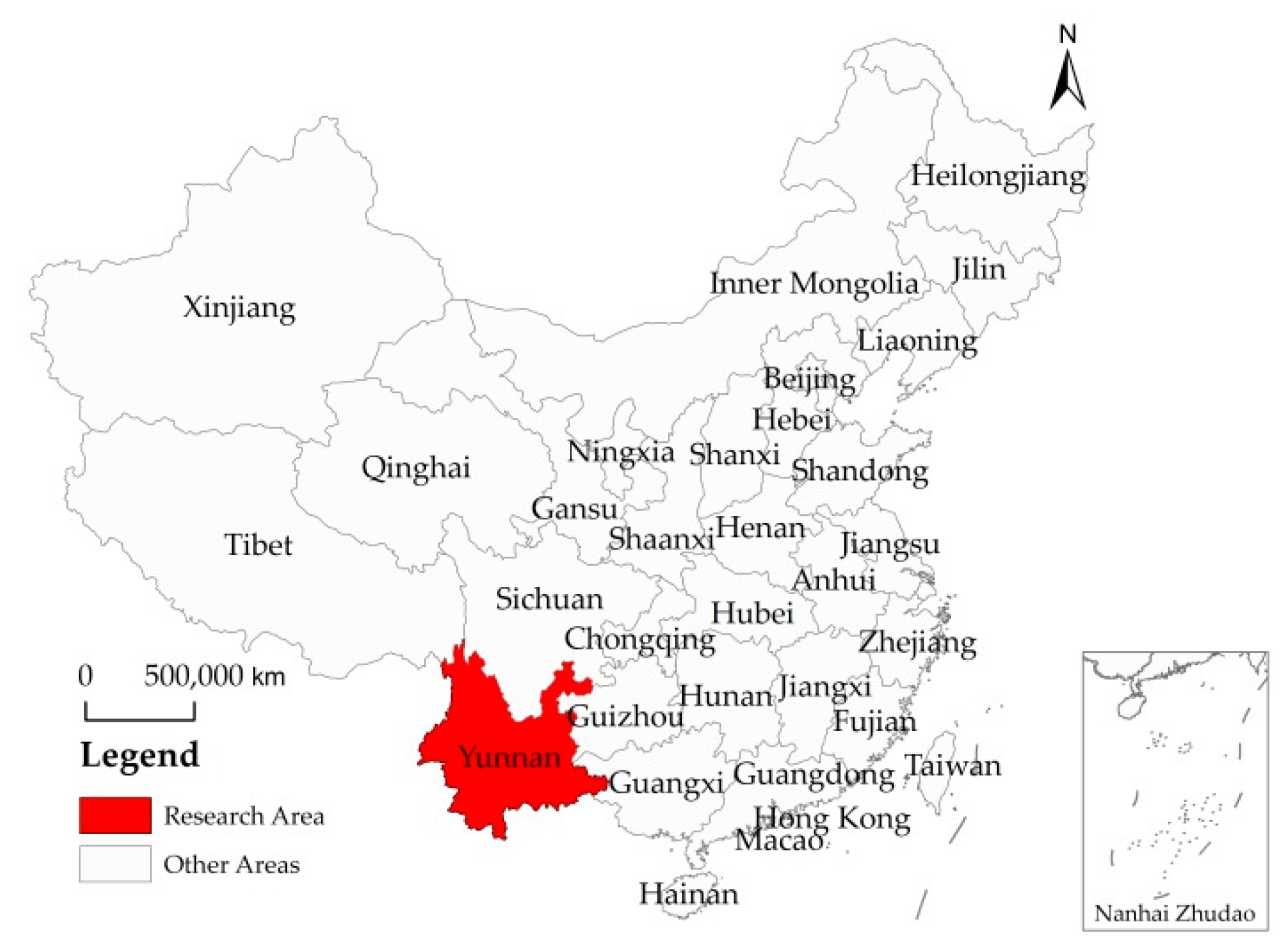
2.1. Overview of the Study Area
2.2. Data Source and Description
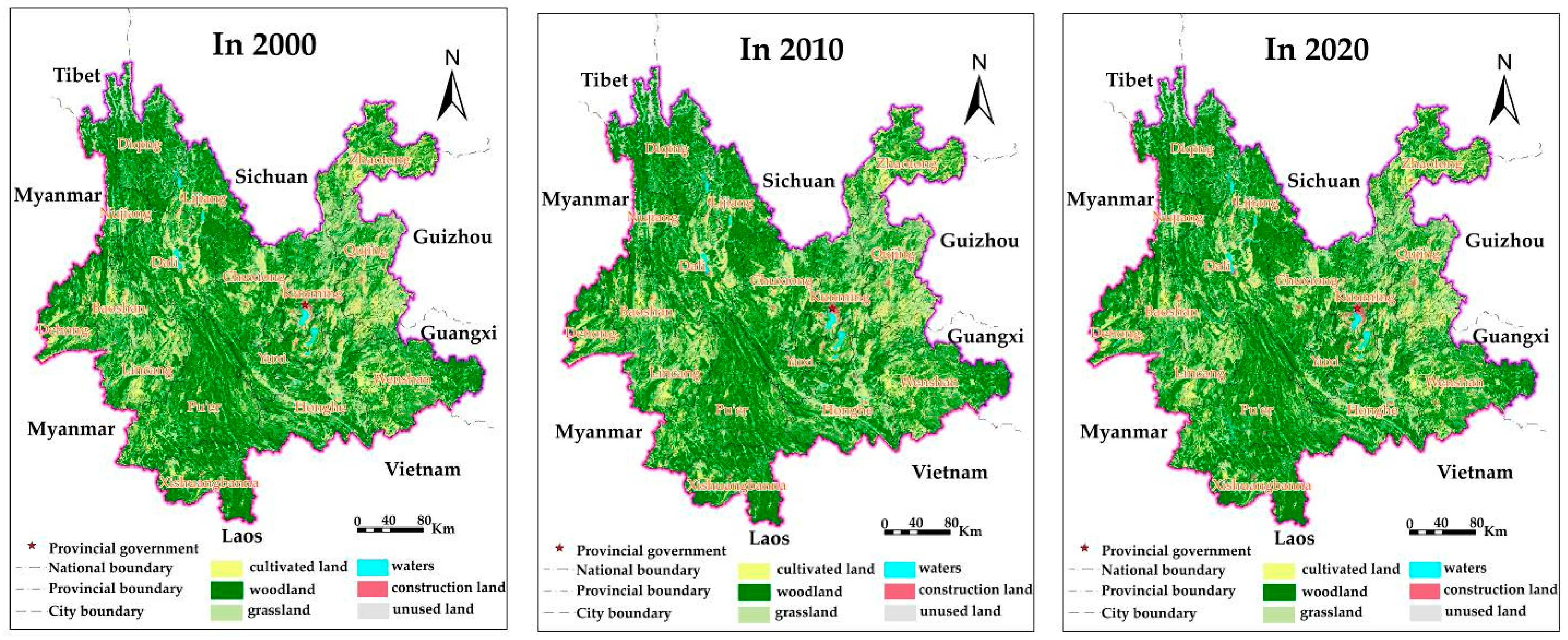
2.2.1. Source and Interpretation of Three Phases RS Image Data
- (1)
- Three increases
- (2)
- Three decreases
2.2.2. Other Data Sources and Descriptions
- (1)
- Socio economic data
- (2)
- Geospatial data
- (3)
- Other basic data and materials
- (4)
- Source of Yunnan county boundary
2.3. Evaluation Method of Land Use Sustainability
2.3.1. Basic Connotation and Criteria of SLU
2.3.2. Basic Ideas and Index System of LUSE
- (1)
- Basic ideas for evaluation
- (2)
- Evaluation index system
- (3)
- Evaluation criteria of LUSE indexes
2.3.3. Comprehensive Method of LUSE
- (1)
- Degrees of Ecological Friendliness (DEF)
- (2)
- Degrees of Economic Viability (DEV)
- (3)
- Degrees of Social Acceptability (DSA)
- (4)
- Degrees of Overall Land Use Sustainability (DOS)
- (5)
- Determination method and result value of index weight
2.3.4. Grading System and Standard of SLU
- (1)
- Classification of EFLU
- (2)
- Classification of EVLU and SALU
- (3)
- Grading of OSLU
3. Results
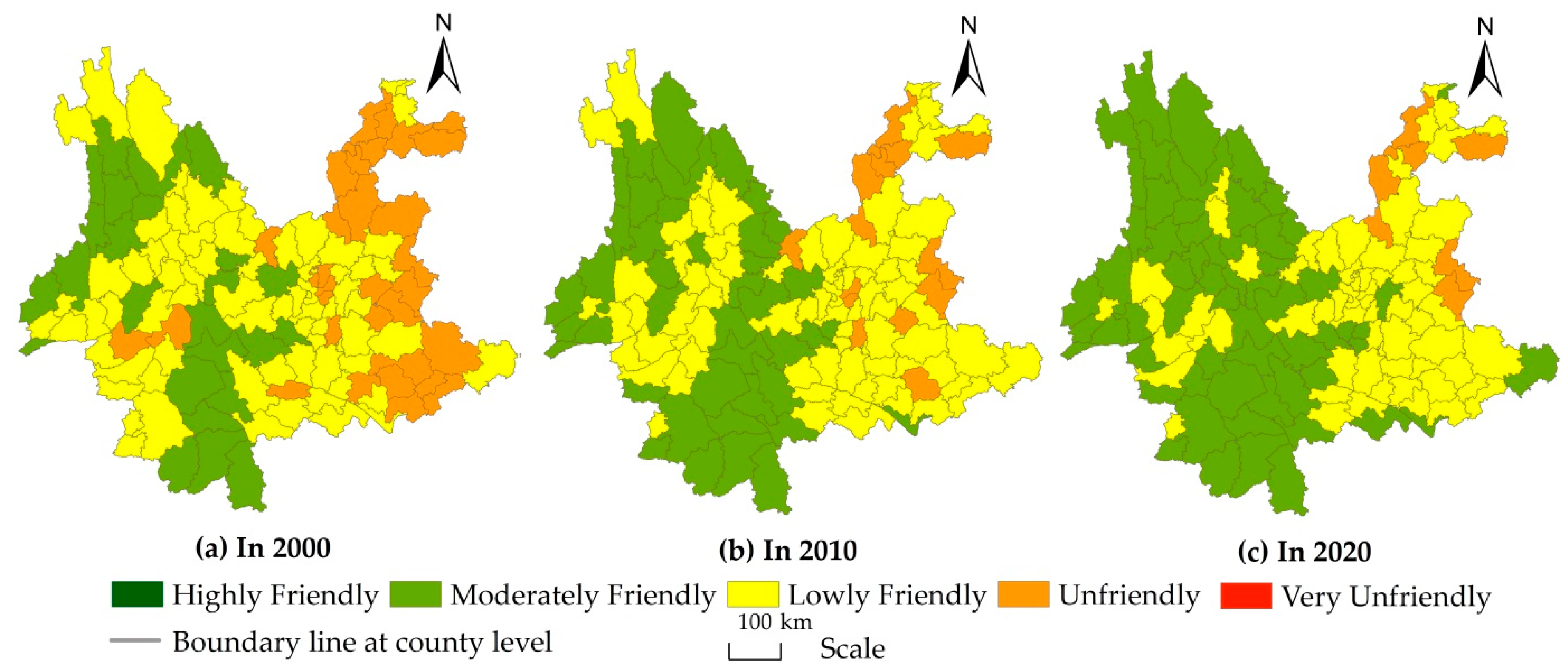
3.1. Spatio-Temporal Characteristics and Causes Analysis of EFLU
3.1.1. Change Characteristics of EFLU in Recent 20 Years
3.1.2. Characteristics of Spatial Differences of EFLU
3.1.3. Analysis of the Causes of Spatio-Temporal Evolution of EFLU
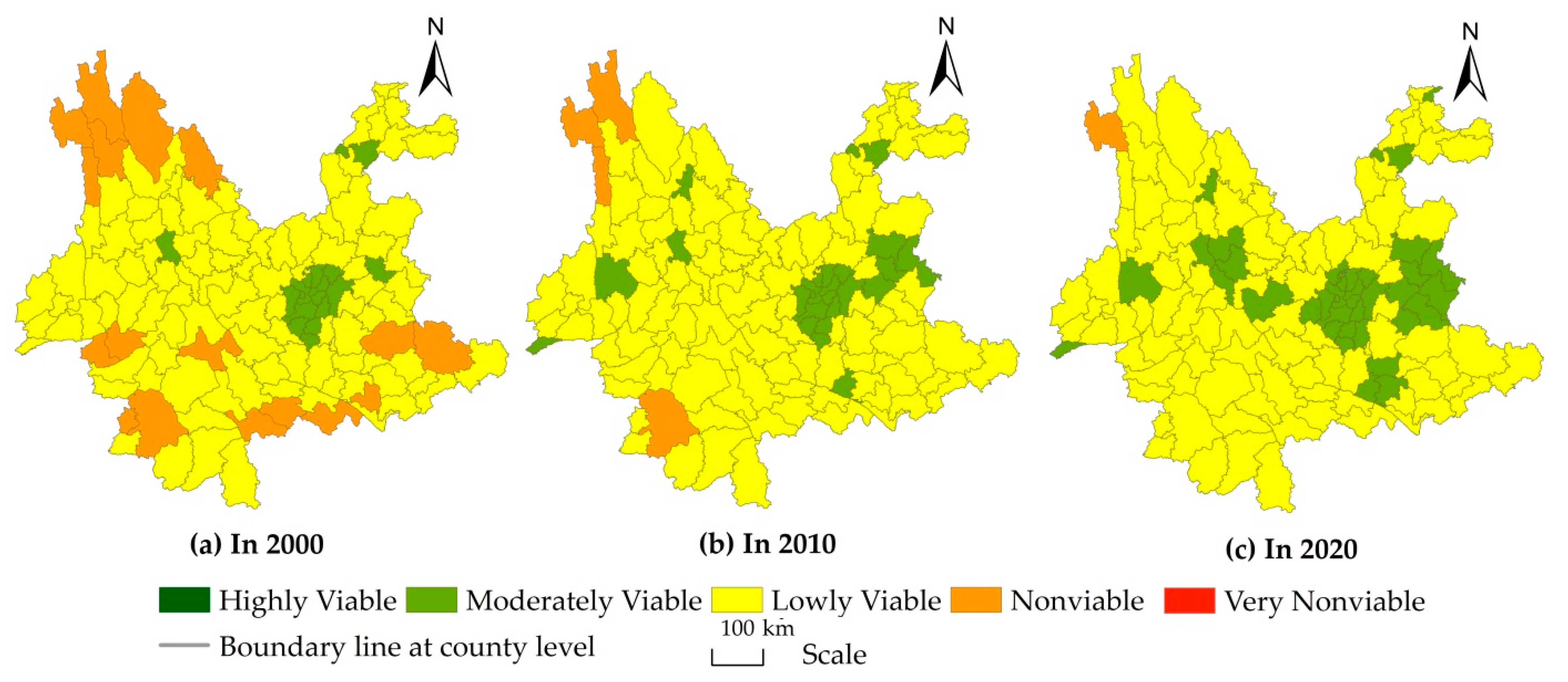
3.2. Spatio-Temporal Evolution Characteristics and Causes Analysis of EVLU
3.2.1. Change Characteristics of EVLU in Recent 20 Years
3.2.2. Characteristics of Spatial Differences of EVLU
3.2.3. Analysis of the Causes of Spatio-Temporal Evolution of EVLU
3.3. Spatio-Temporal Evolution Characteristics and Causes Analysis of SALU
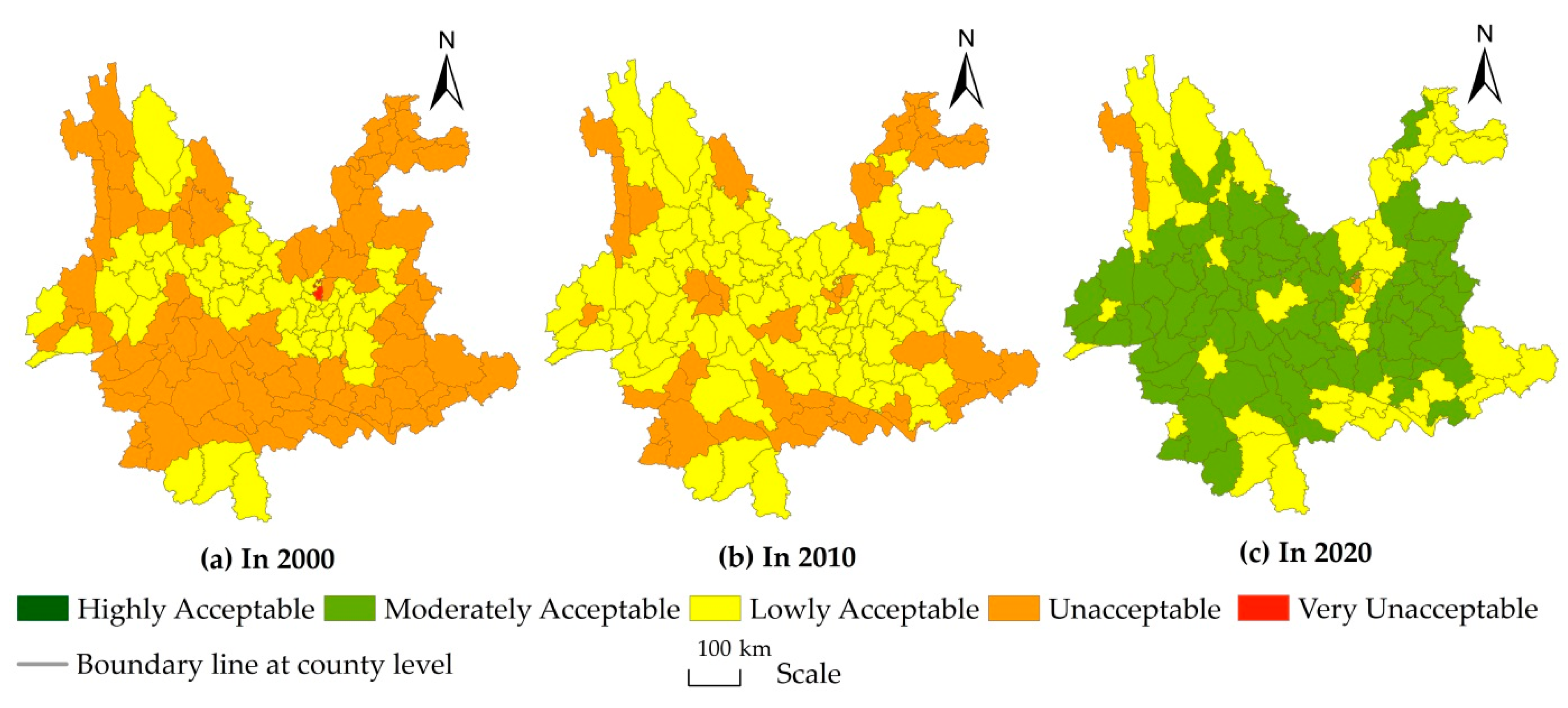
3.3.1. Change Characteristics of SALU in Recent 20 Years
3.3.2. Characteristics of Spatial Differences of SALU
3.3.3. Analysis of the Causes of Spatio-Temporal Evolution of SALU
3.4. Spatio-Temporal Evolution Characteristics and Causes Analysis of OSLU
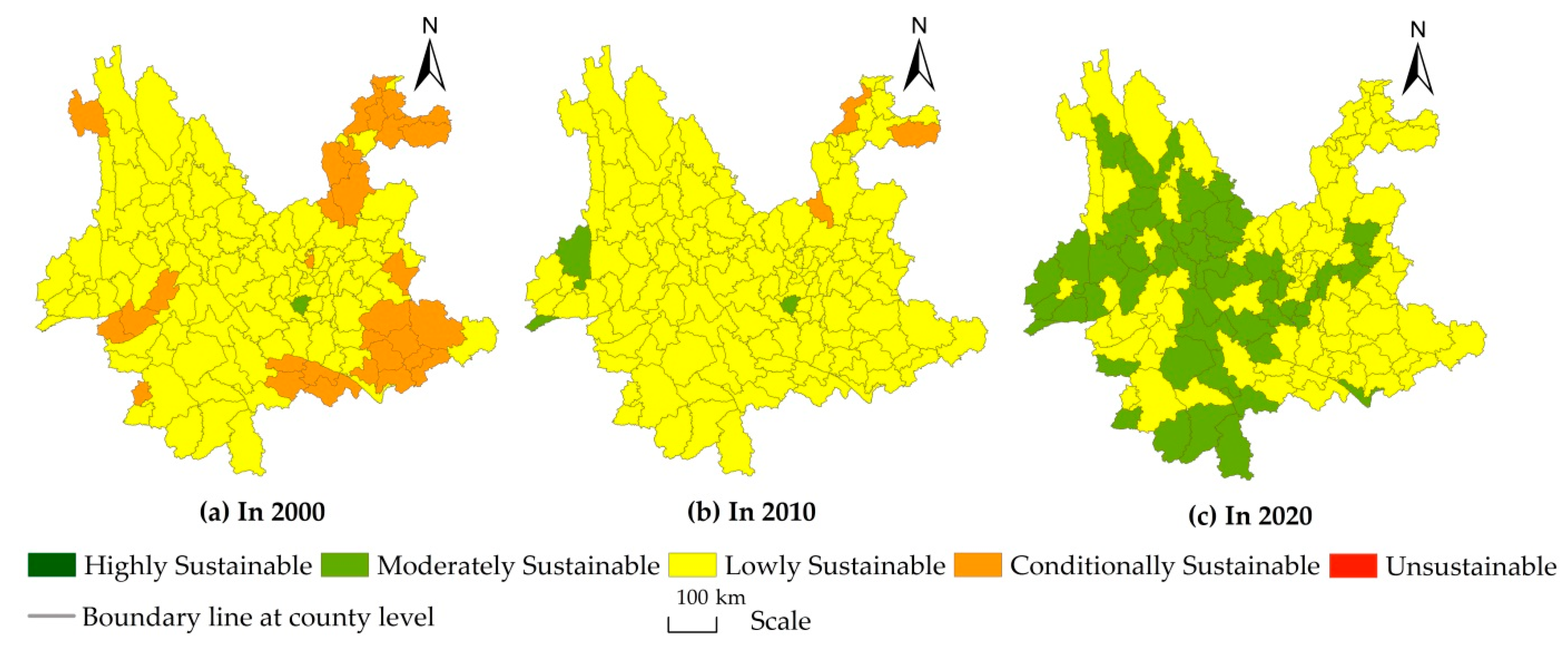
3.4.1. Change Characteristics of OSLU in Recent 20 Years
3.4.2. Characteristics of Spatial Differences of the OSLU
3.4.3. Analysis of the Causes of Spatio-Temporal Evolution of OSLU
4. Conclusions and Discussion
4.1. Main Conclusions
4.2. Discussion
Author Contributions
Funding
Data Availability Statement
Conflicts of Interest
References
- Yang, Z.S.; Liu, Y.S. Study on Eco-Friendly Land Use in Mountainous Areas of China, 1st ed.; China Science and Technology Press: Beijing, China, 2007. [Google Scholar]
- FAO. FESLM: An International Framework for Evaluating Sustainable Land Management; World Soil Resources Report No. 73; Food and Agriculture Organization of the United Nations: Rome, Italy, 1993. [Google Scholar]
- Xie, H.L.; Li, Z.; Xu, Y. Study on the Coupling and Coordination Relationship between Gross Ecosystem Product (GEP) and Regional Economic System: A Case Study of Jiangxi Province. Land 2022, 11, 1540. [Google Scholar] [CrossRef]
- He, W.K.; Yang, J.; Li, X.S.; Sang, X.J.; Xie, X.T. Research on the interactive relationship and the optimal adaptation degree between land use benefit and industrial structure evolution: A practical analysis of Jiangsu province. J. Clean. Prod. 2021, 303, 127016. [Google Scholar] [CrossRef]
- Yang, Z.S.; Liang, L.H.; Li, X.S.; Sang, X.J.; Xie, X.T. Traditional Land Use for sustainable land use: The case of Yunnan Province, China. In Human Resource System Challenge VII: Human Settlement Development, in Encyclopedia of Life Support Systems (EOLSS); Sassen, S., Marcotullio, P., Eds.; Eolss Publishers: Oxford, UK, 2004. [Google Scholar]
- Sun, Y.; Liu, Y.Z. Evaluation of land use sustainability based on land fragmentation: A case on Fenyi County, Jiangxi Province. J. Nat. Resour. 2010, 25, 802–810. [Google Scholar]
- Han, B.; Jin, X.B.; Sun, R.; Li, H.B.; Liang, X.Y.; Zhou, Y.K. Land use sustainability evaluation based on conflict-adaptation perspective. Acta Geogra. Sinica 2021, 76, 1763. [Google Scholar]
- Hu, M.L. Evaluation of sustainable land use in Xuzhou city for SDGs. Nat. Resour. Inform. 2022, 22, 39–45. [Google Scholar]
- Yu, D.; Chen, W.B. Study on Land Use of Sustainability Appraisal and Spatiotemporal Features in Jiangxi Province. China Land Sci. 2009, 23, 43–47,69. [Google Scholar]
- Zhao, X.G.; Pan, Y.J.; Ding, S.; Liu, S.F.; Duan, R.T.; Wei, Q.; Su, H. Evaluation of regional land use sustainability and its spatial-temporal pattern among provinces in China. Trans. Chin. Soc. Agric. Eng. 2014, 30, 196–204. [Google Scholar]
- Xie, H.L.; Liu, Q.; Yao, G.R.; Tan, M.H. Measuring regional land use sustainability of the Poyang Lake Eco-economic Zone based on PSR modeling. Resour. Sci. 2015, 37, 449–457. [Google Scholar]
- Wang, Y.; Guo, C.X. Comprehensive Evaluatioon and Spatia-Temporal Analysis of Sustainable Land Use In Shaanxi Province. Chin. J. Agric. Resour. Region. Plan. 2018, 39, 113–122. [Google Scholar]
- Zhao, S. Research on the Temporal and Spatial Changes of Land Use Sustainability during the Period of Poverty Alleviation in the Middle Reaches of Jinsha River: A Case of Luquan Yi and Miao Autonomous County, Yunnan Province; Yunnan University of Finance and Economics: Kunming, China, 2022. [Google Scholar]
- Zhou, Y.; Xing, L.X. Study on Sustainable utilization of land resources based on remote sensing data. World Geol. 2004, 23, 175–178. [Google Scholar]
- Fu, B.J.; Chen, L.D.; Cai, Y.L.; Li, X.B. Study on Land Use Change and Sustainable Use in the Areas around Bo Hai, 1st ed.; Science Press: Beijing, China, 2004. [Google Scholar]
- Zhang, J.K.; Cheng, Y.P.; Dong, H.; Guo, Q.S.; Liu, K.; Zhang, F.W. Study on Ecological Environment and Sustainable Land Use Based on Satellite Remote Sensing. J. Groundw. Sci. Eng. 2013, 1, 89–96. [Google Scholar]
- Wu, Q.J.; Yang, R.Y.; Yang, Z.S. A Study on the Rationality of Land Use Change in the Dianchi Basin during the Last 40 Years under the Background of Lake Revolution. Sustainability 2022, 14, 11479. [Google Scholar] [CrossRef]
- Yan, J.M.; Shen, Y.; Xia, F.Z. Differentiated Optimization of Sustainable Land Use in Metropolitan Areas: A Demarcation of Functional Units for Land Consolidation. Sustainability 2017, 9, 1356. [Google Scholar] [CrossRef] [Green Version]
- Tan, R.; Hu, R.M.; Vatn, A. What does sustainability demand? An institutionalist analysis with applications to China. J. Chin. Gov. 2021, 6, 486–514. [Google Scholar] [CrossRef]
- Mumtas, M. Sustainability Indicators for Assessing and Monitoring the Sustainable Land Management in the Commercial Rice Zone of the Lower Pak Phanang River Basin, Thailand. Agric. Agric. Sci. Procedia 2016, 8, 77–83. [Google Scholar] [CrossRef]
- Zhou, G. Evaluation of Regional Land Sustainable Use—A case Study of Yanhe County of Guizhou Province, China. J. Guizhou Norm. Univ. (Nat. Sci.) 2006, 24, 31–34. [Google Scholar]
- Sun, Q.; Zhang, X.H. Evaluation of Land Sustainable Utilization Based on Analytic Hierarchy Process in Henan Province. Guizhou Agric. Sci. 2012, 40, 224–230. [Google Scholar]
- Zou, F.; Yan, X.G.; Liu, S.; Chen, Y.L. Comprehensive Evaluation on Sustainable Utilization of Land Resource in Zhangjiajie. J. Jishou Univ. (Nat. Sci. Edit.) 2015, 36, 64–70. [Google Scholar]
- Yang, Z.S.; Liu, Y.S.; He, Y.M.; Tao, W.X.; Xu, J.J. The Principles and Methods of Eco-friendliness Evaluation of Land Use in Mountainous Areas at County Level and Its Case Study. J. Nat. Resour. 2008, 23, 600–611. [Google Scholar]
- Wang, G. Evaluation of Sustainable Land Use—A Case Study of Tianjin City. China Real Estate 2016, 23, 21–31. [Google Scholar]
- Su, C.C.; Zhou, A.; Pan, Y.C.; Wang, A.L. Evaluation of Sustainable Land Use Based on Principal Component Analysis in Longkou City. Chin. J. Agric. Res. Region. Plan. 2018, 39, 96–103. [Google Scholar]
- Huang, P. Evaluation of sustainable land use in A-Ba prefecture based on comprehensive evaluation model. Chin. Contemp. Econ. 2018, 25, 89–91. [Google Scholar]
- Zhao, X.; Ye, J.P.; Xue, S. Evaluation of Urban Land Sustainable Use in Hu’nan Province based on Improved Grey Relational Analysis. Bull. Soil Water Conser. 2013, 33, 265–269+234. [Google Scholar]
- Han, J.H.; Zhao, W.J.; Yang, T.T.; Wang, S.B. Evaluation of Sustainable Land Use and Diagnosis of Obstacle Factors in Agro-Pastroral Zone of Northeast China Based on improved TOPSIS Meshod. Res. Soil Water Conser. 2018, 25, 279–284. [Google Scholar]
- Jiao, S.T.; Wang, P.; Chen, J.X. Sustainable Utilization of land Resources in the Ethnic Areas of Inter-Provincial Boundary of Yunnan, Guizhou and Guangxi: From the Perspectives of Regional Evaluation and Spatial Division. Econ. Geogr. 2019, 39, 175–184. [Google Scholar]
- Pieri, C.; Dumanski, J.; Hamblin, A.; Young, A. Land quality indicators. World Bank Discussion Paper 315. Gener. Infor. 1995, 3, 37–75. [Google Scholar]
- Dumanski, J.; Gameda, S.; Pieri, C. Indicators of Land Quality and Sustainable Land Management: An Annotated Bibliography, 1st ed.; World Bank: Washington, DC, USA, 1998. [Google Scholar]
- Dumanski, J.; Pieri, C. Land quality indicators: Research plan. Agric. Ecosyst. Environ. 2000, 81, 93–102. [Google Scholar] [CrossRef]
- He, R.H.; Zhao, M.; Yu, Y.J.; Tan, X.K. Evaluation of land sustainable use and diagnosis of obstacle factors—Taking Hefei as an example. J. Fujian Agric. Forest. Univ. (Philo. Soc. Sci.) 2020, 23, 47–54. [Google Scholar]
- Wang, Q.; He, R.Z. Health Evaluation of Sustainable Land use in Zhengzhou City. Forest. Inven. Plan. 2021, 46, 7–14. [Google Scholar]
- Wang, H.D.; Yang, X.H.; Wang, L.L.; Peng, M.L.; Li, W.Y. Application on Comparison between Entropy Evaluation Method and Principal Component Analysis in Evaluation of Sustainable Land Use in Guiyang. Guizhou Agric. Sci. 2015, 43, 251–255. [Google Scholar]
- Wang, Y.; Huang, Y.Z.; Guan, Y.L. Evaluation of sustainable land use in ecologically fragile ethnic areas: A case study of Lushui City, Yunnan Province. Jiangsu Agric. Sci. 2021, 49, 226–233. [Google Scholar]
- Niu, W.; Shi, J.; Xu, Z.; Wang, T.; Zhang, H.; Su, X. Evaluating the Sustainable Land Use in Ecologically Fragile Regions: A Case Study of the Yellow River Basin in China. Int. J. Environ. Res. Public Health 2022, 19, 3222. [Google Scholar] [CrossRef] [PubMed]
- Yu, D.F. A brief discussion on the object and content of mountain science. J. Mt. Sci. 1998, 16, 69–72. [Google Scholar]
- Zhong, X.H. Promote the construction of mountain science and push forward the sustainable development of mountain areas. J. Mountain Sci. 1999, 17, 1–2. [Google Scholar]
- Yang, R.Y.; Du, W.Y.; Yang, Z.S. Spatiotemporal Evolution and Influencing Factors of Urban Land Ecological Security in Yunnan Province. Sustainability 2021, 13, 2936. [Google Scholar] [CrossRef]
- Yang, R.Y.; Zhong, C.B.; Yang, Z.S.; Wu, Q.J. Analysis on the Effect of the Targeted Poverty Alleviation Policy on Narrowing the Urban-Rural Income Gap: An Empirical Test Based on 124 Counties in Yunnan Province. Sustainability 2022, 14, 12560. [Google Scholar] [CrossRef]
- Li, J.L.; Hou, B. Sustainable Land Use Evaluation of Mountain Area of North Guangdong Based on the Raster Spatial Data. Bull. Survey Map 2008, 54, 40–43. [Google Scholar]
- Yunnan Provincial Bureau of Statistics. Yunnan Statistical Yearbook 2021, 1st ed.; China Statistics Press: Beijing, China, 2021. [Google Scholar]
- National Bureau of Statistics. China Statistical Yearbook 2021, 1st ed.; China Statistics Press: Beijing, China, 2021.
- Yang, Z.S.; Zhao, Q.G.; Xin, L. Yunnan Land Resources, 1st ed.; Science and Technology of China Press: Beijing, China, 2014. [Google Scholar]
- Office of Yunnan Provincial Agricultural Zoning Commission. Land Area of Different Climatic Zones and Slopes in Yunnan Province, 1st ed.; Yunnan Science and Technology Press: Kunming, China, 1987. [Google Scholar]
- Wang, W.F. Yunnan Soil, 1st ed.; Yunnan Science and Technology Press: Yunnan, China, 1995. [Google Scholar]
- Yunnan Vegetation Compilation Group. Yunnan Vegetation, 1st ed.; Science Press: Beijing, China, 1987. [Google Scholar]
- General Office of the People’s Government of Yunnan Province. The 14th Five-Year Plan for Comprehensive Disaster Prevention, Reduction and Relief in Yunnan Province. Available online: http://www.yn.gov.cn/zwgk/zcwj/zxwj/202204/t20220406_240190.html (accessed on 6 April 2022).
- National Bureau of Statistics. China Statistical Yearbook (2008–2020), 1st ed.; China Statistics Press: Beijing, China, 2008–2020.
- Department of Natural Resources of Yunnan Province. The 14th Five-Year Plan for the Prevention and Control of Geological Disasters in Yunnan Province (2021–2025). Available online: http://dnr.yn.gov.cn/html/2022-8/102349_1.html (accessed on 30 August 2022).
- Xu, X.L.; Liu, J.Y.; Zhang, S.W.; Li, R.D.; Yan, C.Z.; Wu, S.X. Multi-period land use and land cover monitoring data set in China (CNLUCC). In Resource and Environment Science Registration and Publication System; Institute of Geographic Sciences and Natural Resources Research, Chinese Academy of Sciences: Beijing, China, 2018; Available online: http://www.resdc.cn/DOI (accessed on 8 February 2022).
- Liu, J.Y.; Liu, M.L.; Deng, X.Z.; Zhuang, D.F.; Zhang, Z.X.; Luo, D. The land use and land cover change database and its relative studies in China. J. Geograph. Sci. 2002, 12, 275–282. [Google Scholar]
- Liu, J.Y.; Liu, M.L.; Zhuang, D.F.; Zhang, Z.X.; Deng, X.Z. Study on spatial pattern of land-use change in China during 1995–2000. Sci. China (Ser. D) 2003, 46, 373–384. [Google Scholar]
- Liu, J.Y.; Kuang, W.H.; Zhuang, Z.X.; Xu, X.L.; Qin, Y.W.; Ning, J.; Zhou, W.C.; Zhang, S.W.; Li, R.D.; Yan, C.Z.; et al. Spatiaotemporal characteristics, patterns and causes of land-use changes in China since the late 1980s. J. Geograph. Sci. 2014, 24, 195–210. [Google Scholar] [CrossRef]
- Kuang, W.H.; Zhang, S.W.; Du, G.M.; Yan, C.Z.; Wu, S.X.; Li, R.D.; Lu, D.S.; Pan, T.; Ning, J.; Guo, C.Q.; et al. Remotely sensed mapping and analysis of spatio-temporal patterns of land use change across China in 2015–2020. Acta Geograph. Sin. 2022, 77, 1056–1071. [Google Scholar]
- Zhang, F.R.; Wang, J.; Chen, B.M. Evaluation Index System and Method of Sustainable Land Use, 1st ed.; China Agricultural Press: Beijing, China, 2003. [Google Scholar]
- Ministry of Environmental Protection of the People’s Republic of China. Industry Standards for Environment Protection HJ 192–2006, 1st ed.; China Environmental Science Press: Beijing, China, 2006. [Google Scholar]
- Department of Environmental Protection of the People’s Republic of China. National Environmental Protection Standard HJ 192–2015: Technical Criterion for Ecosystem Status Evaluation, 1st ed.; China Environmental Science Press: Beijing, China, 2015. [Google Scholar]
- Xie, G.D.; Lu, C.X.; Leng, Y.F.; Zheng, D.; Li, S.C. Ecological assets valuation of the Tibetan Plateau. J. Nat. Resour. 2003, 18, 189–196. [Google Scholar]
- Yang, Z.S. Study on Land Use Changes and Its Ecological Effects in Different Landform Areas in Yunnan Province Driven by China’s Project of Converting Farmland to Forest, 1st ed.; China Science and Technology Press: Beijing, China, 2011. [Google Scholar]
- Yang, Z.S.; Yang, R.Y.; Liu, F.L. Spatio-temporal evolution and influencing factors of urban-rural income gap in Yunnan Province based on poverty classification. Geograph. Res. 2021, 40, 2252–2271. [Google Scholar]
- Office of the Leading Group of the Third National Land Survey of Yunnan Province, Department of Natural Resources of Yunnan Province, Statistics Bureau of Yunnan Province. Main Data Bulletin of the Third National Land Survey of Yunnan Province. Yunnan Daily, 22 December 2021; 8.
- Master Plan of Major Projects for Protection and Restoration of Important Ecosystems in Yunnan Province (2021–2035). Available online: http://lcj.yn.gov.cn/html/2021/fazhanguihua_1202/64715.html (accessed on 2 December 2021).
- Xu, K.; Yang, Z.S. Research on the Value of Land Ecological Service in Yunnan Province Based on the Perspective of Spatial Pattern. Sustainability 2022, 14, 10805. [Google Scholar] [CrossRef]
- Yang, R.Y.; Zhong, C.B.; Yang, Z.S.; Liu, F.L.; Peng, H.Y. Analysis on poverty influencing factors in deep poverty county of Karst Rocky-desertified Area in Southwest China. World Reg. Stud. 2022, 31, 1298–1309. [Google Scholar]
- Jonathan, A.F.; Ruth, D.; Gregory, P.A.; Carol, A.; Gordon, B.; Stephen, R.C.; Stuart, F.H.; Michael, T.C.; Gretchen, C.D.; Holly, K.G.; et al. Global consequences of land use. Science 2005, 309, 570–574. [Google Scholar]
- Meyfroidt, P.; de Bremond, A.; Ryan, C.M.; Archer, E.; Aspinall, R.; Chhabra, A.; Camara, G.; Corbera, E.; DeFries, R.; Díaz, S.; et al. Ten facts about land systems for sustainability. Proc. Natl. Acad. Sci. USA 2022, 119, e2109217118. [Google Scholar] [CrossRef]
- Lambin, E.F.; Baulies, X.; Bockstael, N. Land-Use and Land-Cover Change: Implementation Strategy, 1st ed.; Scientific Steering Committee and International Project Office of LUCC: Stockhdm, Sweden; Bonn, Germany, 1999. [Google Scholar]
- IGBP. Science Plan and Implementation Strategy, 1st ed.; IGBP Secretariat: Stockholm, Sweden, 2005. [Google Scholar]
- Liu, J.Y.; Zhang, Z.X.; Zhang, S.W.; Yan, C.Z.; Wu, S.X.; Li, R.D.; Kuang, W.H.; Shi, W.J.; Huang, L.; Ning, J.; et al. Innovation and development of remote sensing- based land use change studies based on Shupeng Chen’s academic thoughts. J. Geo-Inform. Sci. 2020, 22, 680–687. [Google Scholar]
- Lu, Y.G.; Cai, Y.L.; Xu, Y.Q. Towards land change science: The progress of LUCC. China Land Sci. 2006, 20, 55–61. [Google Scholar]
- TurnerII, B.L.; Munroe, D.K. Land change science/land system science. In International Encyclopedia of Human Geography, 2nd ed.; Kobayashi, A., Ed.; Elsevier: Amsterdam, The Netherlands, 2020; pp. 87–92. [Google Scholar]
- Verburg, P.H.; Crossman, N.; Ellis, E.C.; Heinimann, A.; Hostert, P.; Mertz, O.; Nagendra, H.; Sikor, T.; Erb, K.; Golubiewski, N.; et al. Land system science and sustainable development of the earth system: A global land project perspective. Anthropocene 2015, 12, 29–41. [Google Scholar] [CrossRef] [Green Version]
- Nielsen, J.O.; de Bremond, A.; Chowdhury, R.R.; Friis, C.; Metternicht, G.; Meyfroidt, P.; Munroe, D.; Pascual, U.; Thomson, A. Toward a normative land systems science. Curr. Opin. Environ. Sustain. 2019, 38, 1–6. [Google Scholar] [CrossRef]


| First Class Land Use Type | Second Class Land Use Type | Land Use Classified Area (Unit: 10,000 hectares) | ||||
|---|---|---|---|---|---|---|
| Number | Name | Number | Name | In 2000 | In 2010 | In 2020 |
| 1 | Cultivated Land | 551.08 | 545.96 | 539.56 | ||
| 11 | Paddy Field | 135.91 | 134.53 | 131.39 | ||
| 12 | Dryland | 415.17 | 411.43 | 408.17 | ||
| 2 | Woodland | 1998.19 | 2224.10 | 2418.67 | ||
| 21 | Closed Forest Land | 1414.58 | 1724.81 | 1884.72 | ||
| 22 | Other Forest Land | 583.61 | 499.29 | 533.95 | ||
| 3 | Grassland | 481.25 | 325.65 | 181.12 | ||
| 31 | Pasture with High Coverage | 307.02 | 195.20 | 105.36 | ||
| 32 | Pasture with Medium and Low Coverage | 174.23 | 130.46 | 75.76 | ||
| 4 | Waters | 49.34 | 53.28 | 56.09 | ||
| 41 | Rivers and Lakes | 31.78 | 31.47 | 31.18 | ||
| 42 | Reservoir and Pond | 17.56 | 21.81 | 24.91 | ||
| 5 | Construction land | 66.72 | 86.73 | 129.69 | ||
| 51 | Urban Construction Land, Rural Settlement Area and Land for Mining and Industry | 54.84 | 74.86 | 109.17 | ||
| 52 | Other Building Land | 11.88 | 11.87 | 20.52 | ||
| 6 | Unused land | 695.85 | 606.71 | 517.30 | ||
| 61 | Bare land | 96.13 | 92.95 | 80.62 | ||
| 62 | Other Land Types | 599.72 | 513.76 | 436.68 | ||
| Indicator Category | Evaluation Indicators | Element Indicator | Calculation Method and Illustrate | The Main Method of Data Acquisition | Control Objective (Relative Optimal Value) |
|---|---|---|---|---|---|
| 1. Ecological friendliness evaluation index | 1.1 IOR | Land suitable reclamation rate | IOR = 100 − [(Actual land reclamation rate − Land suitable reclamation rate)/Land suitable reclamation rate × 100] | Land Survey and Evaluation [1] | Actual reclamation rate ≤ suitable reclamation rate (Over–reclaimed Rate = 0) |
| Actual land reclamation rate | Land survey, remote sensing monitoring | ||||
| 1.2 IBLA | Bare land area | IBLA = 100 −(Bare land area/Total land area × 100) | Land survey, remote sensing monitoring | 0 | |
| Total land area | Land survey | ||||
| 1.3 IEI | Effective irrigated area of cultivated land | IEI = Effective irrigated area of cultivated land/Cultivated area × 100 | Land survey, remote sensing monitoring | 100% | |
| Cultivated area | Land survey, remote sensing monitoring | ||||
| 1.4 IFC | Closed Forest area | IFC = RFC/Highest RFC in the region × 100 Where, RFC (Forest-coverage Rate) = Closed Forest area/Total land area × 100% | Land Remote Sensing Survey (or Forest Census) | ≥67% (Yunnan province’s 2035 Forest Coverage Planning Target) | |
| Total land area | Land survey | ||||
| 1.5 IBRC | Index of Biological Richness (IBR) | IBRC = IBR/Highest IBR in the region × 100 Where, IBR = Abio × (Woodland area × 0.35 + Grassland area × 0.21 + Waters area × 0.28 + Cultivated land area × 0.11 + Construction land area × 0.04 + Unused land area × 0.01)/Total land area; reference value of Abio is 511.2642 [59,60] | Thematic investigations and calculations | Consider the regional context. The relative optimum value was taken as the relative optimum value of the counties with the best ecological protection in the province. | |
| 1.6 IESV | Ecological service value per unit land area (VES) | IESV = VES/Highest VES in the region × 100 Where VES is calculated according to Xie Gaodi et al. [61] (2003) and the corresponding estimation method [62] | Thematic investigations and calculations | Consider the regional context. The relative best value of ecological service per unit land area in the county is taken as the relative optimal value. | |
| 2. Economic viability evaluation index | 2.1 ICLP | Regional GDP per unit land area | ICLP = ln (CLP)/ ln (Highest CLP in the region) Where CLP (Comprehensive land productivity) = GDP/Total land area. Because the index data of some years and counties are not stable, the calculation formula is treated as a natural logarithm. IALP, IBLP, IFRUA, and IPGDP are also the same, aiming to make each index more stable [63]. When the calculated ICLP value is greater than 100, it takes 100 | Socioeconomic Statistics | Regional unit land GDP ≥ national average unit land GDP |
| National average GDP per unit land area | Socioeconomic Statistics | ||||
| 2.2 IALP | Output value of primary industry per unit of agricultural land in the region | IALP = ln (ALP)/ln (Highest ALP in the region) Where ALP (Agricultural Land Productivity) = Output value of primary industry/Agricultural land area | Socioeconomic Statistics, Land Remote Sensing Survey | Regional unit agricultural real estate value ≥ national average unit agricultural real estate value | |
| National average output value of primary industry per unit of agricultural land | Socioeconomic Statistics, Land Remote Sensing Survey | ||||
| 2.3 IBLP | Output value of secondary and tertiary industries of building land in regional units | IBLP = ln (BLP)/ln (Highest BLP in the region) Where BLP (Building Land Productivity) = Output value of secondary and tertiary industries/Building land area | Socioeconomic Statistics, Land Remote Sensing Survey | Regional unit construction real estate value ≥ national average unit construction real estate value | |
| National average unit building land output value of secondary and tertiary industries | Socioeconomic Statistics, Land Remote Sensing Survey | ||||
| 2.4 IFRUA | Fiscal revenue per unit land area | IFRUA = ln (FRUA)/ln (Highest FRUA in the region) Where FRUA (Fiscal Revenue per unit Land Area) = Total local financial revenue/Total land area | Socioeconomic Statistics | Regional fiscal revenue per unit land area ≥ national average fiscal revenue per unit land area | |
| National average fiscal revenue per unit land area | Socioeconomic Statistics | ||||
| 2.5 IYGC | Actual unit yield of grain crops | IYGC = Average annual grain yield per unit area/Crop Potential Productivity | Rural Economic Statistics | Actual productivity = Potential productivity | |
| Crop Potential Productivity | Special Research [1] | ||||
| 2.6 ILUR | Proportion of used land area | ILUR = LUR/Highest LUR in the region Where LUR (Land Use Rate) = Total area of used land/Total land area | Land survey, remote sensing monitoring | Consider the regional context. Take the county with the highest degree of land use as the relative optimal value. | |
| 3. Social acceptability evaluation index | 3.1 IPP | Actual population | IPP = (10-PP)/(10-1) × 100 Where PP (Population Pressure) = Actual population/ PSCL; PSCL = Suitable cultivated area × Proportion of grain sowing × Possible grain yield per unit area/Per capita grain consumption | Socioeconomic Statistics | Actual population ≤ land population carrying capacity |
| Population-Supporting Capacity of Land Resources (PSCL) | Special Research [1] | ||||
| 3.2 IPGDP | Regional GDP per capita | IPGDP = ln (GDP per capita)/ln (Highest GDP per capita in the region) | Socioeconomic Statistics | Regional per capita GDP ≥ national per capita GDP | |
| National GDP per capita | Socioeconomic Statistics | ||||
| 3.3 IDIR | Per capita disposable income of regional rural residents | IDIR = Per Capita Disposable Income of Rural Residents/Highest Per Capita Disposable Income of Rural Residents in the region | Rural Socioeconomic Statistics | Regional farmers’ per capita net income ≥ national farmers’ per capita net income | |
| National average per capita disposable income of rural residents | Rural Socioeconomic Statistics | ||||
| 3.4 IPYG | Per capita food production | IPYG = Per capita grain output (kg/person)/500 kg/person × 100 | Socioeconomic Statistics | Per capita grain output ≥ 400 kg | |
| Per capita food production target | Economic and Social Planning |
| First–Level | Weight | Second–Level Indicators | Weight |
|---|---|---|---|
| 1. DEF | 0.38 | 1.1 IOR | 0.18 |
| 1.2 IBLA | 0.15 | ||
| 1.3 IEI | 0.13 | ||
| 1.4 IFC | 0.20 | ||
| 1.5 IBRC | 0.18 | ||
| 1.6 IESV | 0.16 | ||
| 2. DEV | 0.32 | 2.1 ICLP | 0.22 |
| 2.2 IALP | 0.18 | ||
| 2.3 IBLP | 0.16 | ||
| 2.4 IFRUA | 0.15 | ||
| 2.5 IYGC | 0.12 | ||
| 2.6 ILUR | 0.17 | ||
| 3. DOS | 0.30 | 3.1 IPP | 0.18 |
| 3.2 IPGDP | 0.32 | ||
| 3.3 IDIR | 0.34 | ||
| 3.4 IPYG | 0.16 |
| Level of EFLU | DEF | Meaning |
|---|---|---|
| 1. Highly Friendly | ≥90 | The DEF is very high. The land development and utilization activities do not cause obvious influence and destruction of the ecological environment, and they can ensure the EFLU. |
| 2. Moderately Friendly | 75~90 | The DEF is moderate. Land development and utilization activities have caused a certain degree of influence and destruction of the ecology. By taking general ecological construction and environmental protection measures, the EFLU can be ensured. |
| 3. Lowly Friendly | 60~75 | The DEF is low. Land development and utilization activities have caused significant influence and destruction of the ecological environment. Effective ecological construction and environmental protection projects should be made to promote the EFLU. |
| 4. Unfriendly | 45~60 | The DEF is low. Land development and utilization activities have caused great influence and destruction of the ecological environment. Strong ecological construction and environmental protection measures are needed to ensure the EFLU. |
| 5. Very Unfriendly | <45 | The DEF is very low, and the unfriendliness is particularly prominent. Land development and utilization activities have caused significant influence and destruction of the ecology. It is essential to fundamentally reverse the land use mode and take major ecological construction and environmental protection measures in order to ensure the EFLU. |
| Economic Viability Grading System and Criteria | Social Acceptability Grading System and Criteria | ||
|---|---|---|---|
| Level of EVLU | DEV | Level of SALU | DSA |
| 1. Highly Viable | ≥90 | 1. Highly Acceptable | ≥90 |
| 2. Moderately Viable | 75~90 | 2. Moderately Acceptable | 75~90 |
| 3. Lowly Viable | 60~75 | 3. Lowly Acceptable | 60~75 |
| 4. Nonviable | 45~60 | 4. Unacceptable | 45~60 |
| 5. Very Nonviable | <45 | 5. Very Unacceptable | <45 |
| Level OSLU | DOS | Meaning |
|---|---|---|
| 1. Highly sustainable | ≥90 | The EFLU, EVLU and SALU are all high, so the overall sustainability is high. The land development and utilization activities have not caused obvious influence and destruction of the ecology, and the economic and social benefits are great. |
| 2. Moderately sustainable | 75~90 | The OSLU is medium, and the EFLU, EVLU and SALU have different degrees of deficiencies or defects. Land development and utilization activities have resulted in a certain grade of influence and destruction of the ecology, or economic benefits and social benefits are not high. By taking general measures of ecology and environment, economy or comprehensiveness, it is generally possible to ensure the land use system sustainability. |
| 3. Lowly sustainable | 60~75 | The OSLU is low, and there are significant deficiencies or defects in EFLU, EVLU and SALU. Land development and utilization activities have caused significant influence and destruction of the ecology or economy and are of low social benefit. Measures of effective ecology and environment, economy or comprehensiveness are needed. |
| 4. Conditionally sustainable | 45~60 | The OSLU is low, and the EFLU, EVLU and SALU are largely inadequate or flawed, or one or two aspects of the 3 aspects are largely flawed. Strong measures of ecology and environment, economy or comprehensiveness can improve the OSLU. |
| 5. Unsustainable | <45 | Low OSLU, major deficiencies in EFLU, EVLU and SALU, or major deficiencies in 1–2 of the 3. It is essential to fundamentally reverse the way of land use and take major measures of ecology and environment, economy or comprehensiveness to greatly improve the OSLU. |
Publisher’s Note: MDPI stays neutral with regard to jurisdictional claims in published maps and institutional affiliations. |
© 2022 by the authors. Licensee MDPI, Basel, Switzerland. This article is an open access article distributed under the terms and conditions of the Creative Commons Attribution (CC BY) license (https://creativecommons.org/licenses/by/4.0/).
Share and Cite
Yang, R.; Wu, Q.; Yang, Z.; Yang, S. Study on Spatio-Temporal Changes of Land Use Sustainability in Southwestern Border Mountainous Provinces in Recent 20 Years Based on Remote Sensing Interpretation: A Case Study in Yunnan Province, China. Land 2022, 11, 1957. https://0-doi-org.brum.beds.ac.uk/10.3390/land11111957
Yang R, Wu Q, Yang Z, Yang S. Study on Spatio-Temporal Changes of Land Use Sustainability in Southwestern Border Mountainous Provinces in Recent 20 Years Based on Remote Sensing Interpretation: A Case Study in Yunnan Province, China. Land. 2022; 11(11):1957. https://0-doi-org.brum.beds.ac.uk/10.3390/land11111957
Chicago/Turabian StyleYang, Renyi, Qiuju Wu, Zisheng Yang, and Shiqin Yang. 2022. "Study on Spatio-Temporal Changes of Land Use Sustainability in Southwestern Border Mountainous Provinces in Recent 20 Years Based on Remote Sensing Interpretation: A Case Study in Yunnan Province, China" Land 11, no. 11: 1957. https://0-doi-org.brum.beds.ac.uk/10.3390/land11111957