1. Introduction
Coal mining was and still is a relevant economic activity throughout Europe. Due to its economic importance, the severe local environmental effects, and the given global climatic importance of fossil fuels such as coal, coal mining is the focus of many political and societal debates [
1,
2,
3,
4]. These debates focus in particular on the phasing out of coal mining that causes a couple of economic, social, and environmental structural changes. Structural change is defined as “a complex, intertwined phenomenon, not only because economic growth brings about complementary changes in various aspects of the economy, such as the sector compositions of output and employment, the organization of industry, the financial system, income and wealth distribution, demography, political institutions, and even the society’s value system, but also because these changes can in turn affect the growth processes” [
5] (p. 2).
In 2015, 128 coal mines operated in 12 European member states, with a total annual production capacity of 498 million tons. Germany is the largest producer (184 million tons annually), followed by Poland (135 million), Greece, and the Czech Republic (46 million tons each) [
6].
The coal-mining industry and coal as a fossil energy source as a whole are significant contributors to global greenhouse gas emissions. In 2018, EU ETS emissions from EU member states’ stationary installations had already fallen by 29% since 2005—primarily due to a decrease in the use of hard coal and lignite fuels [
7], but still accounted for 16% of gross inland energy consumption in the EU and 24% of the power generation mix [
6].
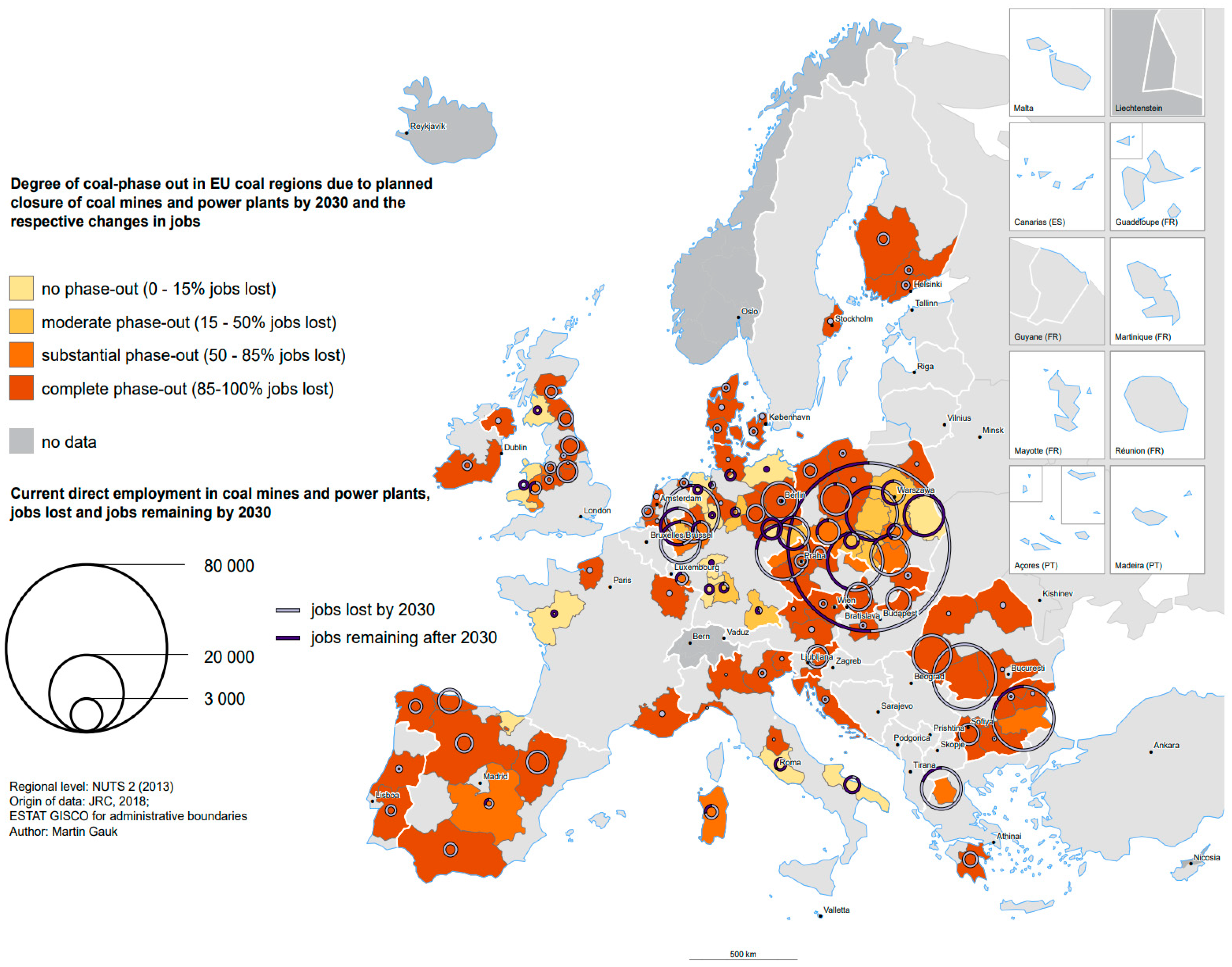
According to ESPON [
8] (p. 5), Europe’s remaining coal-mining regions will be confronted with a substantial job loss till 2030. The Rhenish coal-mining area, which is located between Aachen and Cologne in the German federal state of North Rhine-Westphalia, is characterized by a substantial job loss of about 50–85% of all existing jobs in this sector (see
Figure 1).
The European Commission wants to support territories facing serious socio-economic challenges deriving from the transition process towards a climate-neutral economy in the Union, as propagated by the European Green Deal [
9] (p. 6). For this purpose, the so-called “Just Transition Fund (JTF)” is to be the first of three pillars that constitute the “Just Transition Mechanism (JTM)”. The JTF consists of the three pillars of economic revitalization, social support, and land restoration [
8].
However, the coal phase-out pathways differ considerably between the coal-producing European member states [
2,
10,
11,
12]. First, the temporal perspective: while the UK agreed on a coal phase-out by 2024, in Germany, the coal phase-out is determined by law till 2038 at the latest, and in Poland, representatives of the national government and the workers’ unions signed a treaty in 2021 that defines 2049 as the phase-out date. Second, the transition strategy: while land reclamation in Germany’s surface mining areas is predominantly focusing on an acceptable environmental state, other countries, such as the Czech Republic and Poland, pay more attention to an economically speaking productive use of the former mining area for industrial development and energy production.
Although there are a couple of similar or even more severely affected regions in Europe than the Rhenish coal-mining area, the magnitude of the structural change cannot be solely determined by economic indicators such as production capacity or the number of jobs. The specific feature of this region is its surface mining areas—the largest in Europe—that are characterized by severe changes in the landscape and related forced relocations of human settlements, as well as serious impacts on the regional aquifer and other ecosystem services. In consequence, the still-ongoing mining are activities confronted with serious political protests [
13].
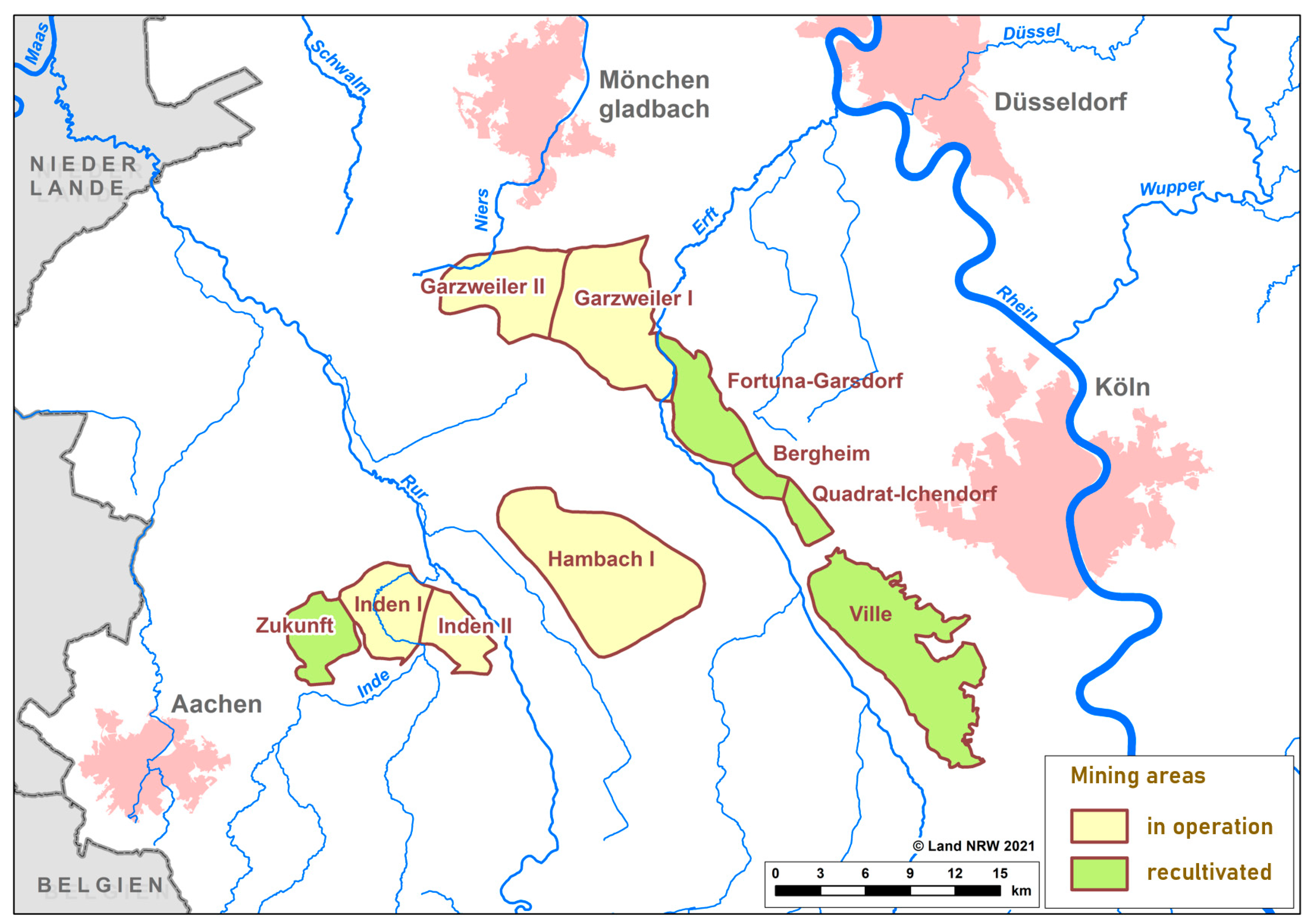
Figure 2 shows the location of the several surface lignite-mining areas in the Rhenish coal-mining region.
Land reclamation is an integral part of any mining project. In Germany, the so-called “Rahmenbetriebsplan” (a general operating plan) in accordance with Art. 52 § 2a Federal Mining Act (Bundesberggesetz) must already consider the necessary land reclamation in the aftermath of the mining activities.
The reclamation of a mine site can involve a number of activities that aim at returning the land and watercourses to an acceptable environmental state and productive use. These activities typically begin with clean-up actions to remove or isolate contaminants, the collection and treatment of any contaminated mine, preventing negative effects on streams and groundwater, the physical stabilization of landforms and structures (mine shafts, tailings, etc.), and the restoration of topsoil [
6,
15] or, specifically in the case of large-scaled surface mines, the creation of artificial lakes (either by groundwater infiltration or controlled flooding) and the stimulation of related touristic activities. Some other, mostly underground mine sites have been reconverted into museums or destined for other cultural activities (such as the World Heritage Site “Zeche Zollverein” in Essen, Germany) [
16].
The energy policy in Germany in the past 20–25 years was subjected to several changes, partly supporting renewable energies, partly re-establishing traditional energy forms. While the German government (first Schröder cabinet) in 2000 officially announced the nuclear phase-out by supporting renewable energy at the same time, in 2005, the first Merkel cabinet re-established nuclear power as a bridging technology, at the cost of renewable energies [
17,
18,
19]. After the Fukushima Daiichi nuclear disaster in March 2011, the German government (second Merkel cabinet) decided again for a nuclear phase-out until 2022 because of the risk potential linked to nuclear technology [
19]. Consequentially, it was decided to use black coal and lignite as a bridging technology until this energy source could be replaced by renewables after a prospective transition time of several decades [
17].
In 2016, Germany signed the Paris Agreement under the United Nations Framework Convention on Climate Change, which aims at the reduction of greenhouse gas emissions as a climate protection strategy so that global warming will be limited to a maximum of 2 degrees centigrade. Although the results of this agreement were partly criticized because of the acceptance of global warming up to 1.5 degrees centigrade, the missing of legally binding emission targets as well as specifics on financial support, and no liability provision linked to financial compensation [
20], the agreement undoubtedly had a strong impact on politics in Germany in the following years. Not only the Fridays for Future movement, but also statements of unions, churches, environmental and conservational associations, and others, gave evidence of a public awareness change, which in turn triggered the German government (fourth Merkel cabinet) to accelerate the energy transition from carbon-based energy sources towards renewable energies. This process was supported by scientists who argued that the existent German climate protection policy targets were just appropriate to limit global warming on a 2 °C level, while the achievement of more ambitious goals, such as a 1.5 °C limit, would need quicker and more effective measures [
21]. As a result of these discussions, in 2018, the German government founded an expert commission on growth, structural change, and employment, which was expected to elaborate a roadmap for a future coal phase-out and energy transition in Germany, based on the necessities and findings of the Paris agreement, as well as on the claims of scientists, environmentalists, and other relevant socio-economic groups [
22]. Specific agreements of the commission’s work are:
Stepwise shut down of 84 coal-fired power plants;
Finalization of electricity generation based on coal until 2038;
Financial compensation for the operators of the coal-fired power plants in the amount of more than 4 billion EUR;
Specific measures in the energy sector;
Development of perspectives for existing, new, and future-proof workplaces;
Evaluation and monitoring of the initiated measures.
The above-mentioned measures in the energy sector comprise a broad range of different activities, such as specific measures for:
Climate protection;
The energy market, electricity tariffs for industry, business, and private end-use customers;
The security of energy supplies;
The power grid, accumulators, sector coupling, and innovation potential;
The added value and employment;
Open-pit mining and secure maintenance of the pits.
The above-enumerated development of perspectives for existing, new, and future-proof work places includes a consideration of impacts, structural policy effects, and visions of the mining regions’ future, explicitly mentioning the Rhenish coal-mining area, which is supplemented by principles of the structural development policy, measures accompanying the structural change, and institutional incorporations [
23]. Finally, the annex of the commission’s final report contains a detailed lists of a broad range of projects for each mining region, covering the issues of the promotion of economic development, promotion of infrastructure and services for the public, promotion of research and development and science and innovation, legal options to experimentalize new issues, and living labs, as well as regulatory and other measures.
The coal phase-out in Germany was regulated by law in 2020 (Kohleausstiegsgesetz, Kohleverstromungsbeendigungsgesetz) [
24], accompanied by critical votes from environmentalists and Green party members, as well as the Fridays for Future movement [
13,
25]. On the other hand, the German government is entitled to accelerate the process of coal phase-out after a mid-term evaluation and monitoring [
24]. Fired by a decision of the Federal Constitutional Court in 2021, the German government was forced to exacerbate and to specify the German Climate Protection Law, especially concerning the period until CO
2 neutrality would be ensured [
26].
Currently, the share of mining, energy, and water management in the overall gross value-added in the Rhenish mining region is 9.0 percent, which is around three times as high as in North Rhine-Westphalia (3.7 percent) or Germany as a whole (3.0 percent). The number of people employed directly in lignite mining is in long-term decline. It reached a peak at around 26,000 in the Rhenish mining region at the end of the 1950s. Between 1990 and 2016, employment, excluding power plant workers, fell from around 15,300 persons to around 8400. The production volume developed cyclically, but declined overall, from a maximum of around 108 million tons in 1992 to around 90 million tons in 2016 [
27]. The general development perspectives in the Rhenish mining area are currently good. Growth in value-added, as well as the number of employees and inhabitants, has been above average since 2000. At indicators of regional location quality, the Rhenish mining area performs better than the state of North Rhine-Westphalia or Germany as a whole. Particularly with regard to factors that are important for a knowledge-based economy, such as the workforce qualification, R&D, broadband infrastructure, universities, and research institutes in the surrounding area, the Rhenish mining area is characterized by several positive development factors. However, important interconnection effects between the lignite industry and the downstream industrial companies are endangered by the transition process, and their competitiveness is severely impacted by rising electricity prices [
27].
It is expected that the end of the mining activities and, as a direct consequence, the shutdown of the thermal power plants powered by lignite coal, will result in a loss of value-added and employment. In total, 14,400 jobs are expected to be lost by 2039. More than two-thirds of this loss of jobs will take place by 2030 due to the rapid closure of a large part of the power plants. However, the 14.8 billion euros of public funding that will flow into the Rhenish mining region by 2038 could generate considerable innovation and growth effects. It is expected that this public funding will provide a private investment impetus of about 22.2 billion euros. Over the funding period, these investments will result in an average of just under 27,000 additional jobs compared with 2021 (trend scenario)—much more than the expected job losses [
28].
Against this background, our paper wants to respond to the following research questions: What are the key challenges of structural change? What are the key physical and institutional characteristics of the Rhenish coal-mining region? What are the key development perspectives of the region?
For this purpose, a GIS-based analysis of key physical and spatial characteristics was implemented. The results of this analysis are presented in
Section 3.1. Institutional characteristics and the governance setting were studied by means of a desk-top analysis of existing planning and policy documents (see
Section 3.2), followed by key elements of the transformation strategy (
Section 3.3).
2. Materials and Methods
The research project DAZWISCHEN (“in between”) was part of the funding activity “Urban-Rural” (Stadt-Land-Plus) that is administered by the German Federal Ministry of Education and Research (
https://www.zukunftsstadt-stadtlandplus.de/at-a-glance-in-english.html, accessed on 21 November 2021). The funding activity follows the transdisciplinary real-life laboratory approach [
29]. Thus, universities and other research institutions collaborate with local and regional practice partners from public administration and civil society. In particular, the funding activity addresses the growing gap between the living environments of urban and rural areas—in dynamic as well as shrinking regions. While the demand for the resource land is intensifying in flourishing regions, shrinking regions face a growing inequality of living conditions. The ultimate goal of the funding activity is the development of innovative solutions for the shared sustainable development of urban, peri-urban, and rural areas, such as a sustainable regional circular economy and the improvement of shared information and data foundations to support the decision-making of actors involved in sustainable land management.
DAZWISCHEN was coordinated by the Department of Spatial Planning at the TU Dortmund University. Further contributing research partners were the Institute for Urban Design at the RWTH University of Aachen and the Institute for Applied Social Sciences. The consortium was complemented by the Zukunftsagentur Rheinisches Revier (regional development agency of the Rhenish coal-mining area), the county of Euskirchen, and the city of Düren as practice partners. They represent the multi-level governance system of the Rhenish mining area.
DAZWISCHEN in particular addressed the extensive structural changes of the Rhenish coal-mining area. The aforementioned German coal phase-out and energy turnaround leads to specific challenges and opportunities for sustainable village, neighborhood, open space, and urban development in the DAZWISCHEN region. In addition to structural change, exogenous developments, especially from the east adjacent Cologne-Bonn metropolitan area, have an impact on the Rhenish mining area.
Furthermore, the project determined the effects of these changes on the functional interdependencies of the whole area, with surrounding large cities and intraregional interdependencies. For consistent data management, a multi-hierarchical spatial information system is to be developed.
3. Results
3.1. The Physical and Spatial Characteristics of the Rhenish Coal-Mining Area
The following chapter addresses the physical and spatial characteristics of the Rhenish coal-mining area. The far-reaching spatial restructuring processes that have been taking place in the region for decades in the course of lignite use and subsequent recultivation are leading to major landscape and spatial changes. The Rhenish mining area has a variety of settlement structures and landscapes. In addition to the large cities of Mönchengladbach, Aachen, and Neuss, as well as medium-sized towns such as Düren, there are numerous municipalities with centuries-old village structures. Such rural structures stand in stark contrast to new housing developments, which for years have been increasing in number and size along the edges of the agglomerations of the before-mentioned larger cities, as well as the bordering corridor along the Rhine River, where the cities of Düsseldorf, Cologne, and Bonn are situated. In terms of landscape, the diversity in the region, with its large contiguous agricultural areas and important nature conservation areas with essential climatic effects, is no less.
The large open-cast mines with their barrier effect have prevented a coherent development of the area for decades, which means that the decision to phase out the coal mining in the near future entails major potential in terms of settlement and landscape structure. Beyond structural change, other external developments, such as settlement pressure from the mentioned Rhine corridor, have an impact on the Rhenish mining area. Despite the predominantly small-scale settlement structure, the region between Aachen, Mönchengladbach, Düsseldorf, Cologne, and Bonn is an “in-between area” characterized by the agglomeration periphery, which is coming under strong pressure from the population growth in the metropolises. The region as a whole is expected to continue to have a high demand for development areas for housing, commerce, and industry, which the metropolises alone will not be able to meet. At the moment, the Rhenish mining area is losing large areas due to the migrating open-cast mines, which are being prepared for reuse with a time lag, so the land disposition necessary for shaping structural change is being restricted. In addition, land competitions arise that can only be solved across the different spatial levels and must take future trends—such as climate change or mobility change—into account.
The Rhenish mining area is also characterized by socio-demographic change. The region is currently faced simultaneously with growth impulses from the metropolises (Aachen and the Rhine corridor) and shrinking processes in the peripheral parts of the region (especially in the Eifel). However, the increasing ageing and heterogenization of society must also be addressed, with these changes having a region-wide impact on requirements for mobility, forms of housing, infrastructures, open spaces, and, last but not least, the guarantee of services of general interest. This includes, for example, a sustainable realignment of transport infrastructures or opportunities for a balance as well as an improvement in living conditions and the quality of services of general interest between the metropolitan core areas on the one hand and the peripheral parts of the region on the other.
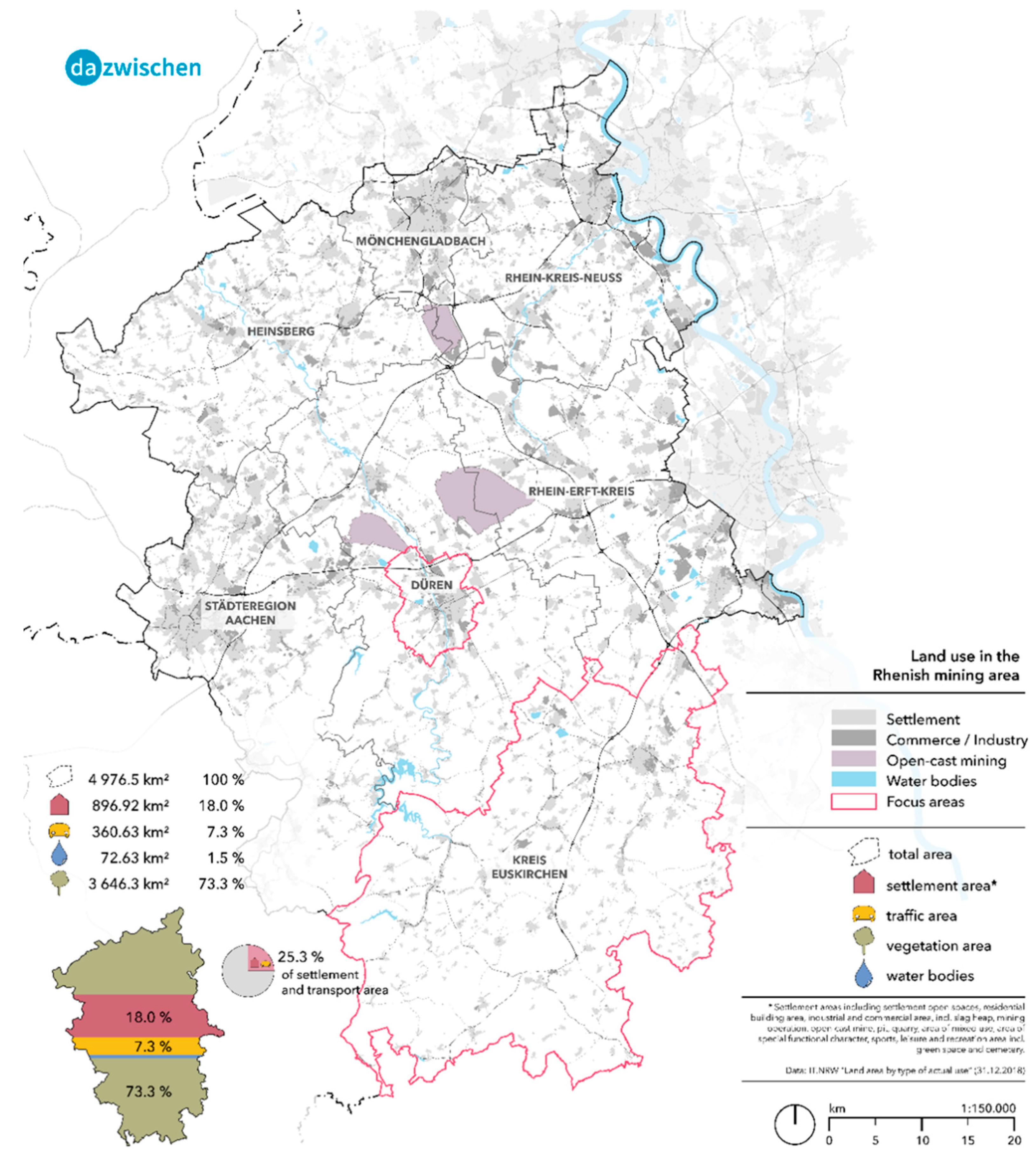
The land distribution within the Rhenish mining area, shown in
Figure 3, shows a settlement- and mobility-percentage of 25%. If we look at exemplary sub-areas, the diversity in the settlement structure already mentioned becomes particularly clear. The municipalities of Jüchen, Hürth, Wesseling, and Alsdorf, which border the cities of Mönchengladbach, Cologne, and Aachen, have a percentage of settlement and mobility areas of over 50%, while municipalities such as Hellenthal or Dahlem in the rural south have values of less than 10%.
Figure 3.
Land use and land distribution in the Rhenish mining area. Source: own Figure.
Figure 3.
Land use and land distribution in the Rhenish mining area. Source: own Figure.
A similar pattern emerged with the analysis of the settlement density in the Rhenish mining area in
Figure 4, which shows the number of inhabitants per km² of settlement and mobility area (incl. settlement open spaces) at the municipality level. The densely populated agglomerations around Aachen, Mönchengladbach, and along the Rhine corridor contrast with the rural area of the northern Eifel, thus creating a clear north–south divide within the region.
Figure 4.
Settlement density in the Rhenish mining area at municipality level. Source: own Figure.
Figure 4.
Settlement density in the Rhenish mining area at municipality level. Source: own Figure.
When considering the development of settlement areas, the data from 2016 onwards are only comparable with the previous years to a limited extent due to the changeover from the automated land register (“automatisiertes Liegenschaftsbuch”, ALB) to the automated land register information system (“automatisierete Liegenschaftskataster-Informationssystem”, ALKIS). However, the period under consideration, 1995 to 2015, showed a trend towards a steady increase in buildings and open spaces, recreational areas, and transport areas. It is only the agricultural land that constantly decreased.
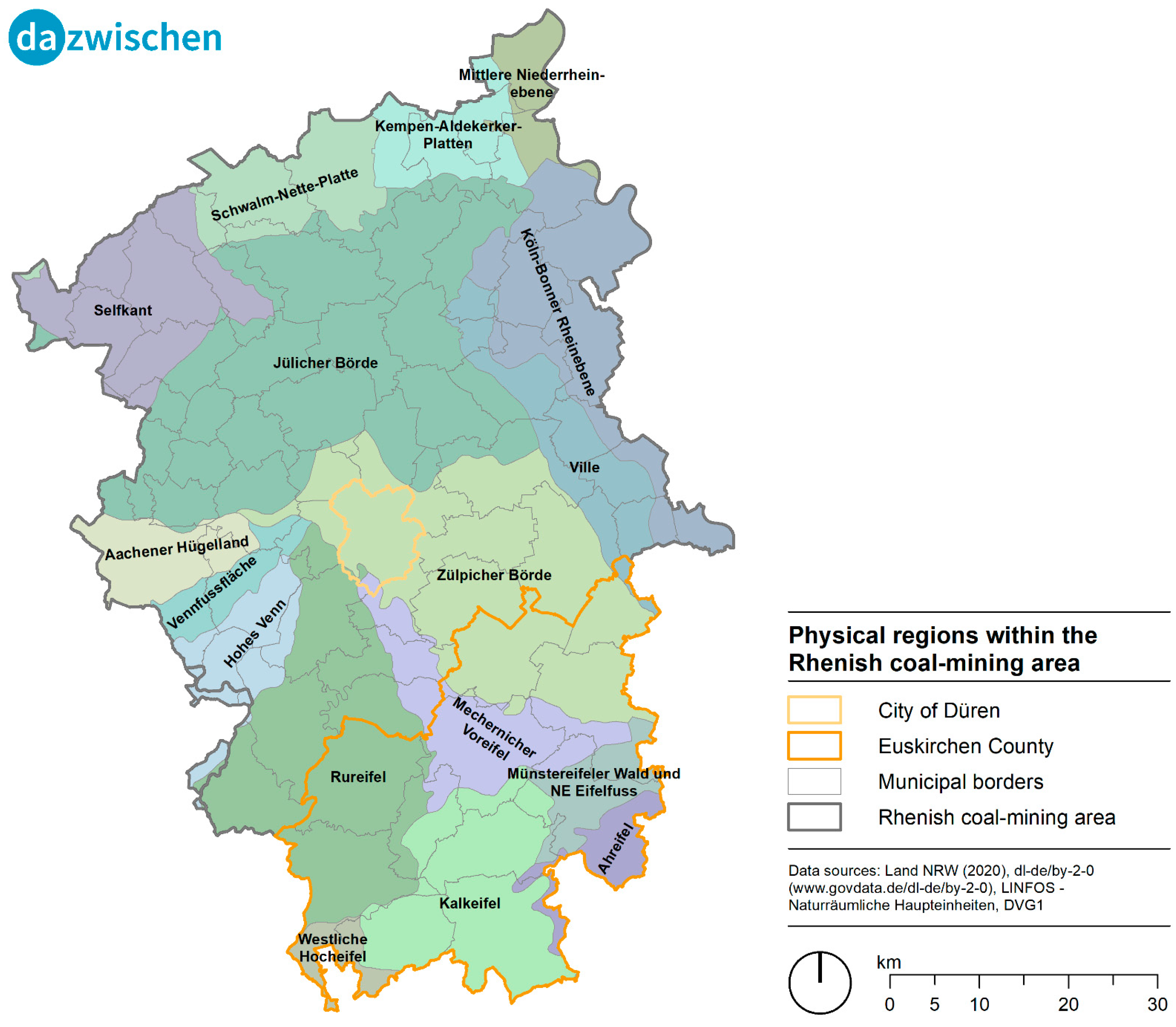
The Rhenish coal-mining area can be roughly characterized by two different landscape types: the average mountain landscape in the southwest with high annual precipitation rates (≥800 mm/a), and the lowlands in the northeast with a mean precipitation of about 650 mm/a, including flat loess soil areas as well as Holocene zones adjacent to the Rhine River and its tributaries (
Figure 5).
Figure 5.
Physical regions within the Rhenish coal-mining area. Source: own Figure.
Figure 5.
Physical regions within the Rhenish coal-mining area. Source: own Figure.
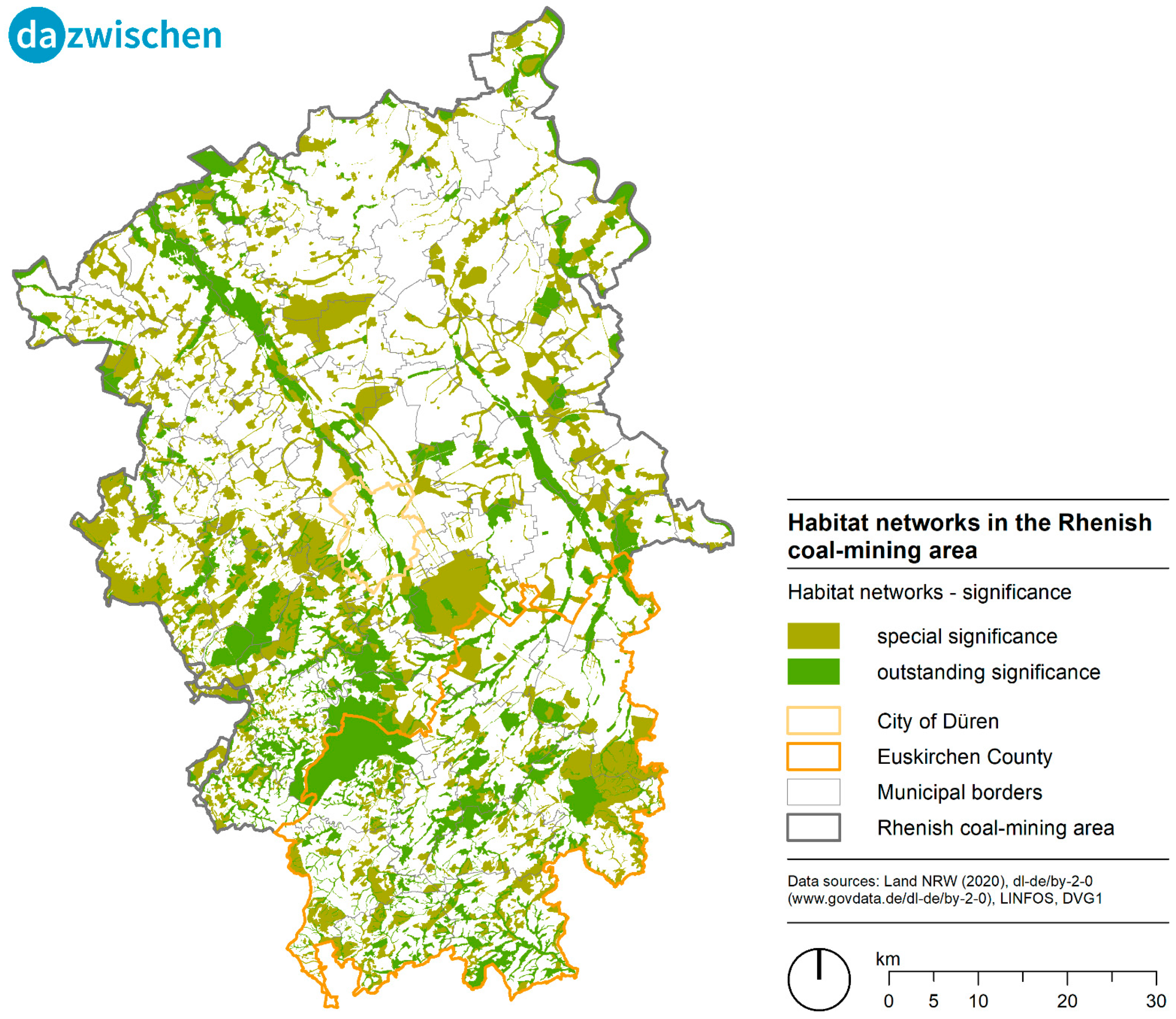
While the lowlands in the northeast comprise “Jülicher Börde”, “Zülpicher Börde”, and all other landscapes north from the two mentioned landscapes, the average mountain landscapes are located south from “Jülicher Börde” and “Zülpicher Börde”. Because of the high fertility of the loess soils, the Börde landscapes, at least since Roman times, have been, to a high extent, used as arable land. The soil quality in the hilly average mountain landscape is much lower, leading to a higher degree of grassland and forests, with the consequence of more diversified habitats and a rich, attractive, and partly protected landscape, which can be used for recreational purposes, as well (
Figure 6).
Urban development is most dynamic around the cities of Cologne (Köln-Bonner Rheinebene) and Aachen (Aachener Hügelland). As pointed out in
Figure 2, the coal mines are mainly located in the center of the northern part of the Rhenish coal-mining area (between Cologne and Aachen), mainly in the above-mentioned Börde landscapes, thus creating a lot of land-use conflicts between preserving the given agricultural functions and settlement demands in this area.
Figure 6.
Habitat networks in the Rhenish coal-mining area. Source: own Figure.
Figure 6.
Habitat networks in the Rhenish coal-mining area. Source: own Figure.
3.2. The Governance Structure of the Rhenish Coal-Mining Area
In order to counteract this structural change in the Rhenish lignite region in a preventive manner, the “Innovationsregion Rheinisches Revier GmbH” (Innovation Region Rhenish Mining Region, IRR) was founded in 2014, which was subsequently transferred to the “Zukunftsagentur Rheinisches Revier” (Rhenish Mining Region Agency for the Future, ZRR) as a joint platform and trailblazer for the transformation process. The state of North Rhine-Westphalia (NRW) has given the ZRR the task of managing the process of structural change. In order to develop the post-mining landscapes, the former open-cast mining areas are to be reconnected with the surrounding space and thus open up innovative and sustainable development perspectives. The Rhenish mining area is to be transformed into a sustainable mobility, industry, and energy region. This transformation process is to be developed by the “Revierknoten” (a territory node) in cooperation with the regional planning authorities, the municipalities in the region. With the corresponding specifications in regional and local legally binding land-use planning, the development perspectives can be taken into account in the final mining plans still to be approved under mining law, so that municipal planning concepts can be realized [
30]. The “Revierknoten” (a territory node), with their respective chairmen, accompany and shape the future issues. In a first step, the district node chairmen and their teams played a key role in drafting the economic and structural program and thus provided the guidelines for the operational implementation of structural change.
The Economic and Structural Program for the Rhenish Mining Area 1.0 (WSP 1.0) was published in December 2019 as a first draft of a vision for the future of the Rhenish mining area for the period after lignite. Responsible for the Economic and Structural Program 1.0 was the ZRR, whose supervisory board and shareholders’ meeting adopted it. The program was drawn up in just a few weeks—between September and November 2019—in close consultation with the people in the region and on the basis of insights gained at specialist conferences and workshops. It was handed over to the North Rhine-Westphalian state government as part of the precinct conference in December 2019.
The WSP 1.0 addressed the future fields of “Energy and Industry”, “Resources and Agribusiness”, “Innovation and Education”, and “Space and Infrastructure”, which were rounded off by a perspective outlook at an International Building and Technology Exhibition.
The objective of the program is to set out the approach and relevant content so that the funding provided is used with the greatest possible impact. In this sense, the WSP represents the content-related basis for future project and site developments, as well as funding decisions, and is reflected, discussed, and updated accordingly in a broad-based participation process with the people, actors, and institutions in the Rhenish mining area. In an intensive participation process, common guidelines, the so-called “Revier-Charta”, were drawn up, which define the guard rails for the further process design.
In June 2021, the updated version of the WSP 1.1 was presented to the public and will henceforth serve as the basis for the content-related orientation of the transformation process. On the way to a mission statement for the Rhenish mining area, guidelines were defined that must guide the shaping of the region:
- -
A livable region that combines attractiveness with value creation;
- -
A high-performance region that remains competitive within Europe;
- -
An innovative region that exploits the future potential of its companies and research institutions;
- -
A climate-neutral region that is consistently oriented toward a circular economy, resource efficiency, and climate neutrality;
- -
A networked region that generates new value-added networks through infrastructure, new technologies, and the interlinking of players.
The territory nodes are oriented to these guidelines, in particular the “Revierknoten Raum”, which has taken on two central functions: to establish a space laboratory as a knowledge repository for spatial development and to develop an informal spatial strategy with the Rhenish Revier 2038+ (a platform which manages the spatial strategy).
The research project DAZWISCHEN was closely linked to the spatial strategy process in terms of structure and content. Thus, analysis results from the DAZWISCHEN project have been used as a basis for the spatial strategy and—vice versa—the project was able to benefit from initial scenarios and events of the “Revierknoten Raum”.
This policy decision and the associated approach are due to the recognition that informal planning processes are becoming increasingly relevant in making land-use designation decisions and in gaining the acceptance of local people. The relevance of an informal set of plans is strengthened by the fact that two formal regional plans for the Düsseldorf and Cologne administrative districts are relevant for the Rhenish mining area. Informal planning can overcome this demarcation in jurisdiction.
The creation of the informal planning strategy has a major impact on the decision makers in formal planning already in the process. These are actively involved in the discourse. The spatial strategy is a technical contribution (“Fachbeitrag”) to the formal regional plan. Moreover, the informal planning strategy addresses different time horizons, beyond the temporal validity of the regional plans.
The Spatial Strategy 2038+ is an informal planning process carried out by territorial nodes on behalf of the Ministry of Economic Affairs, Innovation, Digitalization, and Energy of the Federal State of NRW. The process of developing the Spatial Strategy 2038+ itself is structured in different phases:
- -
Phase 0: inventory, analysis, and preparation of planning works;
- -
Phase 1: development of spatial images in alternatives;
- -
Phase 2: deepening of content and spatial guidelines;
- -
Phase 3: participation and consolidation in an integrated spatial image.
The political representatives, as well as the planning experts in the municipal administrations, are intensively involved in the preparation process.
After alternative development concepts have been presented to a broad public for discussion, a process of participation by the various municipalities, initiatives, and associations follows in order to arrive at a synthesis that is supported as widely as possible and represents a consensus for spatial development in the Rhenish mining area.
The expert findings are fed into the formal planning processes of the regional plans of the districts of Cologne and Düsseldorf. As a technical contribution, the spatial strategy supports the preparation and updating of the two regional plans that contain binding designations on land-use for the Rhenish mining region.
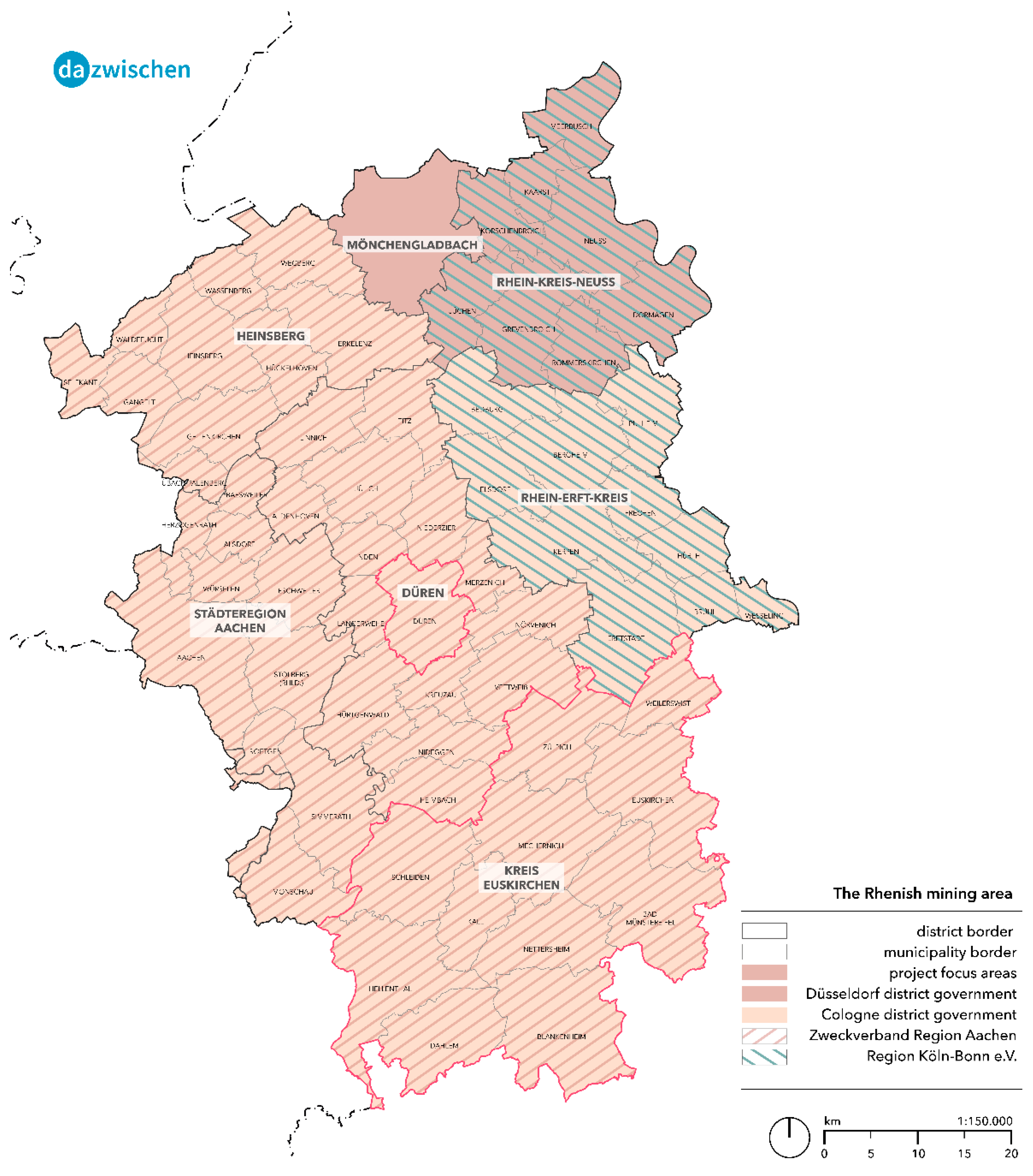
In the Rhenish mining region (see
Figure 7), the Cologne district government, which is responsible for the Heinsberg County, the Düren County, the Euskirchen County, the Rhine–Erft County, and the Aachen city regions, and the Düsseldorf district government, which includes the city of Mönchengladbach and the Rhine county of Neuss, are two administrative units with different focuses and processes. The respective regional plans are in different processing phases and have different methods for calculating the land requirements both for the ASB (priority zones for general settlement purposes) and for the GIB areas (priority zones for commercial and industrial purposes). For instance, although both district governments rely on population projections up to the year 2040 when calculating residential land requirements, they already follow different approaches in dealing with replacement requirements and fluctuation reserves. The subsequent distribution to the municipalities is also carried out with different weightings and parameters.
In addition to the district governments, the Rhenish mining area is home to various interest groups, including the Köln-Bonn e.V. (Club) and the association (Zweckverband) of the Aachen region; each covers only parts of the area. Countless economic development agencies, associations, chambers, and political bodies with their own interests make the region a complex conglomeration of interests at different planning levels.
One example is the decisions on new land-use designations, in which the respective district government sets out the binding but rather abstract requirements in the form of the regional plan. It is ultimately up to the political decisions within each municipality to (re-)activate reserve areas or to designate new areas in the local land-use plan. The counties, with their overarching perspective, have little influence on such local developments and can only intervene locally on a small scale to a limited extent with their (informal) development concepts (Kreisentwicklungskonzept).
A look at the different scale levels and planning instruments shows that an informal planning strategy tailored to the challenges is becoming increasingly important. These include information bases and concepts, communicative and cooperative approaches, and formats for planning concepts such as the Spatial Strategy 2038+ and the spatial visions for the Rhenish mining area, developed within the research project DAZWISCHEN.
Figure 7.
Political and association-based bodies in the Rhenish coal-mining area. Source: own Figure.
Figure 7.
Political and association-based bodies in the Rhenish coal-mining area. Source: own Figure.
3.3. Intended Open-Pit Reuse in the Rhenish Coal-Mining Area
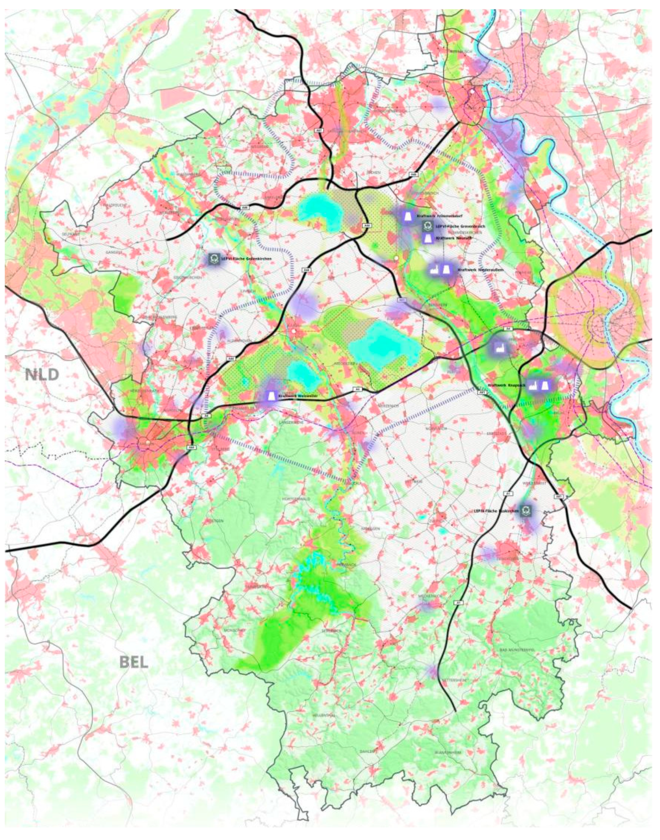
The transformation map (
Figure 8) of the Rhenish Revier, which is a result of the still-ongoing regional development process, organized by the “Revierknoten Raum”, shows that the region has different characteristics, talents, and gifts that need to be taken into account for spatial development. One main focus is on extending and upgrading the regional transport network and the follow-up uses for the surface mining areas.
However, the reuse of open pits in the Rhenish coal-mining area at least theoretically contributes to a higher degree of freedom concerning the allocation of future land use, because the mining areas can be replaced in the long term by other land-use types. The public discussion mainly focuses on the development of new recreation areas, including a vital blue and green infrastructure, consisting, among others, of woods, meadows, and lakes (see
Figure 8). The filling of the lakes will take until about 2090 and depends on the amount of available water, which may decline according to climate change. The “transformation areas” (marked in purple), currently used by thermal power plants, powered by lignite coal, are the designated incubators for new economic activities. In addition, the valid state development plan already contains two large development areas that can be used for large-scale industrial projects.
Figure 8.
Structure plan: transformation map. Source: own Figure.
Figure 8.
Structure plan: transformation map. Source: own Figure.
4. Discussion
This paper presents the complex spatial structural challenges facing coal-mining regions in general and the Rhenish coal-mining region in particular. This gives rise to a number of further research needs.
The complexity of the governance structure in the Rhenish coal-mining area raises the question of how discourse and decision-making processes take place in the context of creating development strategies and why which interests prevail [
31,
32]. This requires an in-depth view of the ongoing working processes in the development of ideas and visions for regional mission statements of different planning areas, levels, and network partners in a real-life laboratory, as described by
Section 3.2 [
29]. Informal planning comprises procedures and instruments of spatial planning that are not legally formalized, standardized, and directly legally binding and at the same time characterized by high flexibility, adaptability, and openness [
33].
For this purpose, a multi-stage workshop process seems to be appropriate. In a first step, the results of the analysis, which were developed together with the county of Euskirchen and city of Düren, could be presented to a broader professional public in order to validate them. At the same time, the previous regional and local planning objectives should be reviewed and compared with the results of the analysis. The goal is to identify possible inconsistencies between the structural challenges on the one hand and the political goals on the other. The final step of interaction could then work with the political bodies to adapt the political goals in such a way that they better meet the identified structural challenges.
In this paper, we touched the issue of settlement development pathways and related planning processes. Nevertheless, it seems necessary to take a closer look at the inherent uncertainties, methodological assumptions for land-use modelling, and regional planning approach involved, which is characterized by the so-called counterbalance principle of local and regional interests [
34].
As already discussed by the introduction to this paper, the Rhenish coal-mining area is characterized by surface mining activities, which are related with serious impacts on the environment and its ecosystem services [
1]. Our trend scenarios suggest an increased pressure on blue and green infrastructure by new urban development, especially in the northern part of the Rhenish coal-mining area, where such landscape elements traditionally have been rare. On the other hand, the southern part of the Rhenish coal-mining area, which is characterized by a high degree of natural structures, such as woods, meadows, and other specific habitats, will be more likely to undergo a process towards an increase in green infrastructure. Thus, the future development of the whole area is segregated in two different development trends in the north and south parts. This process is accompanied by the loss of fertile soils, especially in the northern part of the coal-mining area, which will be a future limitation for conventional as well as organic agriculture practiced close to densely populated areas. Necessarily, this these trends go in line with the deterioration of several ecosystem services. These current and foreseeable future impacts need to be investigated in greater detail [
35].
The structural changes in the Rhenish coal-mining areas are influenced by global climate change and its regional and local effects. These effects should be estimated by means of scenario pathway-based parallel modelling of socio-demographic and climatic changes for a reference period and different future scenarios [
36,
37]. At the same time, these expected climate impacts should be taken into account when deriving spatial development strategies [
38,
39].
Settlement development has always been closely interlinked with mobility issues [
40]. Therefore, scholars argue for an integrated land-use and transport planning approach [
41,
42], which requires a sound evidence basis of the current and future mobility patterns in the area under investigation. Furthermore, the spatial development strategy should be designed in such a way that the use of public transport is optimized—for example, by allocating further settlement areas close to network nodes of the public transport system.
The structural changes in the region are not only caused by the phase-out of mining activities, but are also related to land-use and demographic changes and, as mentioned above, also influenced by climate and mobility changes. However, a further key determinant is the provision of services of general interest. They are, on the one hand, indispensably needed for maintaining equal living conditions that are guaranteed by the German constitution law (the principle of equality of Art. 3 in conjunction with Art. 20 § 1 on the welfare state principle), but also related to territorial cohesion, which is a key policy concept of the European Union. It aims at the reduction of disparities between the levels of development of the various regions and the backwardness of the least favored regions [
43]. The existence and quality of service provision, on the other hand, is an important framework condition for land-use modelling and land-use policies (see, for instance, the central-place theory) [
44]. These aspects require a sound knowledge of the spatial distribution of services of general interest.
Any spatial development should be based on a sound evidence basis [
45,
46], and furthermore, require the European Strategic Environmental Directive and the Environmental Impact Assessment Directive to engage in a continuous monitoring of unforeseen environmental impacts [
47,
48]. This context should be addressed by a spatial information system that is to be designed to enable the regional and local actors to determine structural changes and their foreseeable impacts, as well as to continuously monitor the effects of their interventions.


