
Landscape-Based Transformation of Young Industrial Landscapes


Department of Geosciences and Natural Resource Management, Faculty of Science, University of Copenhagen, Rolighedsvej 23, 1958 Frederiksberg, Denmark
*
Author to whom correspondence should be addressed.
Land 2022, 11(6), 908; https://0-doi-org.brum.beds.ac.uk/10.3390/land11060908
Submission received: 30 April 2022
/
Revised: 4 June 2022
/
Accepted: 7 June 2022
/
Published: 15 June 2022
(This article belongs to the Special Issue Landscape Architecture: Design for Urban Transformation)
Abstract
:Due to deindustrialisation, young industrial landscapes (YILs), stemming roughly from the 1930s to the 1970s and located in the suburbs of Copenhagen, are partly abandoned, partly in use, and partly used for non-industrial purposes. By virtue of their location, size, and unused and underused subareas, YILs can potentially meet major urbanisation aims, such as densification and mixed-use development, yet the redevelopment of YILs often happens from a hypothetical virgin land position, disregarding the existing features of these sites. In this paper, we aim to introduce value-sustaining strategies for a more site-informed transformation of YILs. The specific objective is to investigate and understand the landscape-based transformation of young industrial landscapes by making explicit use of their site features in what we label the landscape. Based on a literature study of the emerging phenomenon, a screening of landscape-based projects and a case study, we present a set of qualifying strategies to guide future landscape-based transformations: porosity, reuse, re-naturing, and open-endedness. The complimentary spatial, multi-scalar, and temporal strategies were demonstrated through the study of the five European cases: Alter Flugplatz Kalbach, Hersted Industripark, IBA Emscher Park, Louvre Lens Museum Park, and Parc aux Angéliques, to exemplify how the strategies could guide the landscape-based transformation of YILs or similar types of large-scale landscapes. Although apparently straight forward, the formulation of the four strategies linking ethics and transformation practices provides a much needed set of values and tools in the current, and also historical, redevelopment of YILs, which are a significant part of our urbanised landscapes, to better address societal challenges.
1. Introduction
Through a study of five European cases, we, in this paper, investigate and characterise strategies for the physical transformation of young industrial landscapes (YILs), each resting on a landscape-related set of values that can be labelled landscape-based transformation. By discussing and suggesting such strategies for landscape-based transformation, we aim to inspire and expand the horizon for how transformation of YILs can build upon the heterogeneous physical landscape and address societal challenges related to urbanisation, nature, health, and the climate crisis.
1.1. Tabula Rasa Approach versus Landscape-Based Transformation
The transformation of urban landscapes is often caused by shifting societal values and the demands of an ever-expanding city. De-industrialisation has profoundly altered urban landscapes in Europe since the late 1950s [1], opening space for urban expansion to take place within the existing urban fabric and thus avoiding the consumption of virgin land. Since the 1980s and 1990s, older industrial areas and other disused or unused facilities typically close to city centres have gained attention as places for potential redevelopment [2,3]. The urgency of reclaiming and recycling former industrial areas in Europe was acknowledged by the EU 30 years ago [4]. Traditionally, industrial landscapes have been perceived as vacant areas [5] and their redevelopment was seen as something that falls under urban planning and design. Most of such projects have taken a “tabula rasa” approach, treating the existing structures on site as obstacles.
More recently, new perspectives on landscape transformation based on the integration of the existing structures have emerged. In response to urban redevelopment practices, in which urban development and heritage conservation were seen as conflicting and as opposed to cooperative processes, UNESCO developed the Historic Urban Landscape approach in 2011 [6]. Likewise, the redevelopment of former industrial areas has been increasingly perceived as a landscape-related opportunity, leading to greening projects in which post-industrial areas are turned into green spaces [3]. Former monofunctional industrial areas are increasingly undergoing restructuring designed to provide new urban functions, and, in various ways, address societal challenges related to urbanisation, nature, health, and climate change [7,8].
Transformation of former industrial landscapes has mostly focused on older industrial areas and harbours, which are often close to inner cities and lend heritage values and visual significance to transformation projects [9,10,11,12]. Many of these old industrial areas are now redeveloped and re-urbanised, and a similar process is encompassing industrial areas in the suburbs [13,14]. Due to continued urban growth, the YILs in the suburbs or outskirts of large cities are next in line [15]. This study reflects on the differences between the tabula rasa approach and the landscape-based transformation, the latter being significantly underdeveloped, especially in a young industrial landscape context.
1.2. Young Industrial Landscapes and Their Transformation Potential
This article draws on previous studies of Danish YILs, which will serve to exemplify YILs’ development and current situation [16,17]. In contrast to old industrial areas in the inner cities, YILs dating from the 1930s to 1970s are usually located on the outskirts of larger towns, and in particular along the so-called “Capital H” that connects all major conurbations in Denmark [15,16]. YILs, in contrast to industrial landscapes from inner cities or harbours, are typically regarded as more generic and with few architectural and spatial elements that are relevant to future redevelopment [9,15,18]. However, they nonetheless possess spatial features and qualities, both site-specific and general, which can be reused and built upon in future transformation processes [16,17].
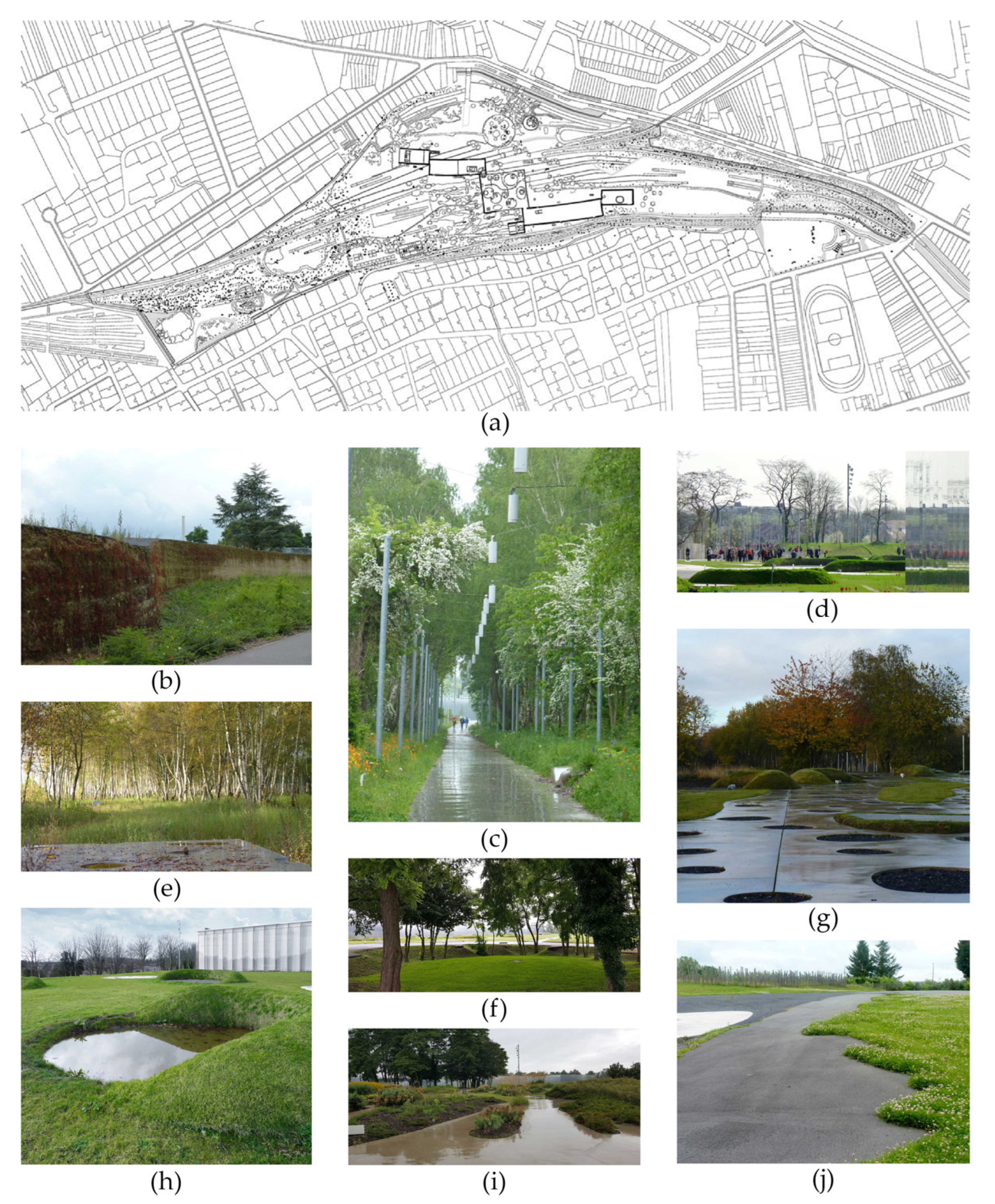
The edge zones of YILs are more than simply narrow linear borders; often they are extensive areas that include channels, ditches, earthworks, and forest-like plantings. Together with the overall defining grid structures, road networks, plot systems, extensive paved areas, roadside planting strategies, as well as elements, such as buildings with long continuous façades and flat roofs, YILs have strong potential for site-specific transformation with heritage, ecological, and recreational qualities in focus. Today, the YILs are partly in use, partially unoccupied, and partially used for other purposes such as retail development, offices or residential use. Due to their location, their large land resources, and the low intensity of use with many unused and underused square metres, YILs offer opportunities to make changes within existing urbanised spaces. In the Copenhagen capital area, henceforward named Copenhagen, a light rail system is currently under construction along the highway Ring 3, transportation features that make the post-industrial spaces more accessible and attractive for private investment. Several municipalities along this stretch have recently presented aims for the overall redevelopment and plans for the specific physical and programmatic transformation of the YILs. These plans are, for the most part, about densification, proximity to public transport and change of use from industry into residences and offices. Some of the plans show a move away from erasing the existing structures and toward an increased understanding of the structures and qualities of YILs. One example of such a plan is presented in Figure 1. This project serves as both an example of a YIL from the local Copenhagen context and as an example of how to address the existing landscape. However, other plans from Copenhagen reveal that planning authorities currently lack appropriate strategies and tools for acknowledging the existing site features of YILs.
YILs along Ring 3 in Copenhagen were mainly planned and built from the 1930s and 1970s, however, some continued their development in the following decades. In the 1930s, Copenhagen experienced a lack of space, which is why a new location of industrial developments were moved to the suburbs [19]. In the beginning of the 1970s, the energy crisis changed the industry’s geographical location needs in Denmark [19] and caused stagnation in production and changes from manufacturing production towards logistics, storage, and knowledge production in Copenhagen. The YILs are icons of the modernist industrial city as they materialise planning principles such as decentralisation, segregation, single-use zoning, repetition, and strong automobile dependence in the wake of Fordism and the Athens Charter of CIAM [9,15,20]. These principles also shaped the suburban context across Europe and North America. Other studies have identified, investigated or mentioned similar post-industrial landscapes in Belgium, Italy, Germany, Great Britain, and the USA [14,21,22,23,24,25]. Given that YILs cover vast expanses of land—up to 25% of the total area in some Danish suburbs—our understanding of these landscapes is astonishingly limited [15,26].
In this paper, we aim to introduce landscape-based and site-informed approaches toward the transformation of YILs specifically. This can be extended to large-scale urban sites in general. The objective of this paper is to investigate and understand the landscape-based transformation of YILs, in which site features are intentionally used. We pose the overall research question: What landscape-based transformation strategies are relevant for YILs? Before attempting to answer the question, we need to determine how to best define and categorise landscape-based transformation. What can we learn from literature on landscape-based transformation and related strategies, ideas, and philosophical worldviews? Which strategies can we identify in transformation projects and how do these strategies address site features and landscape characteristics (materialities, structures, and spaces)? How can we bridge knowledge from literature and built/unbuilt projects and demonstrate multiple incremental and multi-scalar ways of implementing landscape-based transformation in practice?
2. Materials and Methods
Much like a design process, our research process has oscillated between knowledge gained from literature and that from cases and practices. In our attempts to answer the main question and subquestions we raise, we explore and elaborate our findings and foundations. We used the following methods: literature search, the screening and selection of relevant projects dealing with landscape-based transformation, the transformation of YILs or areas of similar age and with similar features and syntaxes, case studies of multiple selected projects to gain insight into the phenomenon of landscape-based transformation, and exemplifying guiding strategies for landscape-based transformation. We present the methodology step by step to tell our story, but in practice, the process has been iterative and we have switched between as well as worked partly simultaneously with the different methods.
Step 1: Literature Search leads to a description of what we label a European/North American paradigm for landscape-based transformation, describing what we can learn from literature about landscape-based transformation, and identifying strategies around landscape-based transformation and prevailing ideas and philosophic worldviews behind it.
Step 2: Screening of Projects builds on a compilation of approximately 40 projects stemming from literature focusing on landscape-based transformation of YILs or post-industrial and other disused and underused landscapes that share spatial characteristics with YILs. To broaden our perspective and to avoid the pitfall of focusing only on well-known older cases, we enlarged our baseline by screening post-industrial projects (approximately 80) from the landscape architectural platform Landezine and all projects (approximately 200) from the foundation Landscape Architecture Europe (LAE). Landezine is an international landscape architectural website showcasing landscape architecture projects from around the globe since 2009. It has more than 5000 visitors per day and promotes annual awards in specific categories, including public landscapes and infrastructure landscapes. The LAE foundation publishes a triennial yearbook in collaboration with the International Federation of Landscape Architecture (IFLA Europe) to strengthen dialogue in landscape architecture on a European level and to provide critical reviews of European landscape architecture. To study a range of state-of-the-art projects, we included realised projects as well as competition submissions. In addition, we included a few cases from our local context of Copenhagen. From approximately 320 projects, we selected 30 projects to investigate further. The aim of the screening process was to examine enough projects to reflect the range, diversity, and variation of landscape-based transformations. The collected data were organised accordingly: title and location; design and client; time (conception, production, and transformation phase); size (hectares); type of plan and transformation; spatial characteristics. The compilation serves to illustrate general trends in landscape-based transformation and to ensure that the following selection of five main cases are representative of specific trends.
Step 3: Case Study of Five Selected Projects. Through the literature search and the screening of the large number of projects, we noted four recurring themes also resonating with the identified societal challenges [7,8], which we investigated in depth and subsequently explained and unfolded through five cases. Based on the screening, we selected five innovative projects for closer scrutiny including a morphological analysis. The five cases were selected to obtain a maximum of variation [27] concerning: approach to transformation, landscape and site-features (porosity; reuse; re-naturing; open-endedness); original transformation site and type of transformation (such as a 150-year-old industrial wasteland/brownfield region into a vibrant green region; a specific YIL dating roughly from the 1960s to the 1980s transformed into sustainable business areas; industrial harbour transformed into a green park for outdoor recreation; a former mining area/wasteland transformed into a museum park; a US Army helicopter airfield dating from 1951–1952 into a site for outdoor recreation); scale (from a regional scale of 80,000 hectares to a local scale of 7.7 hectares); geography and location (projects from three countries, one regional project, two suburban projects, one inner city project, one project in a smaller town), and type of plan (regional strategy, urban strategies, architectural competition proposal). For the presentation of specific cases, see Figure 1, Figure 2, Figure 3, Figure 4 and Figure 5. The morphological analysis was made using Google Street View, maps, pictures, drawings from the design offices of specific landscape architects, and from literature.
Step 4: Presenting and unfolding Guiding Strategies for Landscape-Based Transformation. This process takes the literature review, the screening of projects, and the case studies as a point of departure. Together, these investigations have improved our understanding of landscape-based transformation. This leads us to present four strategies for transformation: porosity, reuse, re-naturing, and open-endedness. Inspired by Corner, who has outlined themes and principles for the practice of landscape urbanism [28], Spirn, who has suggested principles for the design of resilient cities [29], and Sijmons, who has proposed establishing ethics and philosophic worldviews related to the design profession [30], our intention is to bridge the gap between theory and practise by using strategies as stepping stones. We seek to instrumentalise the theory into usable strategies that can inspire and qualify future landscape-based transformation of young urban landscapes or YILs. For this purpose, we used the cases to exemplify the presented strategies and to demonstrate how the strategies can contribute to landscape-based transformation on several levels and scales. Case 1, Hersted Industripark, is presented initially in the introduction as an example of a YIL from the local Copenhagen context to set the stage. It therefore serves a slightly different role than cases 2–5, each exemplifying one of the four strategies.
3. Theoretical Perspectives
As we found research on the transformation of YILs to be rather sparse, we initially adopted a wide perspective to look at landscape-based approaches to the transformation of post-industrial or similar areas in general. In recent decades, researchers have been studying the transformation of older derelict industrial landscapes or similar areas, referred to in terms such as: post-industrial or former industrial areas/landscapes, brownfields, derelict industrial land [2,9], wasteland [21,31], worn-out landscapes, landscapes of the past [32], and landscapes of industrial excess [33]. Other researchers have focused on similar types of landscapes in regard to new functions and referred to them as business sites/districts [34,35], city edge office parks [36], and eco-industrial parks [37].
Several authors described and categorised different overall perspectives on the transformation of former industrial landscapes [7,9,21,38], while other researchers examined a specific sub-aspect of transformation. Loures and Panagopoulos analysed and uncovered three different strategies for the reclamation and transformation of industrial areas: heritage, environment, and socio-culture [39]. Each of these strategies is explained respectively through the cases of Duisburg Nord, Fresh Kills, and Downsview Park, along with their unique landscape characteristics. Braae situated the transformation of post-industrial landscapes in the crossfield of heritage and sustainable urban transformation [9], indicating the cultural historical resonance of working with the industrial relics as ruins and fragments, as well as the importance of including their heterogeneity in the current urban vocabulary to counteract the ongoing homogenisation of urban development globally. From a transformation perspective, Braae laid out four time-based strategies for mutually relating the past, present, and future. The various time value systems touch on morphological, semiological, phenomenological, praxeological, and ecological aspects. Furlan analysed urban approaches to wasteland and categorised three perspectives: anthropocentric, ecological, and cyclical [40]. According to Furland, the anthropocentric perspective emphasises territory as a space to be tamed for the sake of human applications. It legitimises a focus on the human conditions rather than viewing things from a general ecological perspective.
Our perspectives on transformation have been inspired by these aforementioned writers. We structured landscape-based transformation of YILs into four main perspectives: socio-cultural use, heritage, environmental and ecological, and processual and cyclic. These perspectives are not exclusive and do not delimit one another; on the contrary, they help in creating awareness of various simultaneously embedded aspects. Each perspective is presented and discussed in regard to trends related to the transformation of YILs.
Common to these four perspectives is that the existing physical landscape of young industrial areas is not regarded as an obstacle for future transformation. Instead, the existing landscape and its physical site features are seen as potentials that inform the transformation process. First, the existing YILs represent layers of local culture and history. Secondly, YILs contribute with spatial and aesthetic experiences that differ from those found in other urban areas. Thirdly, instead of the tabula rasa approach, existing materials on site are reused, which prevents green field development elsewhere and potentially helps in lowering CO2 emissions when compared to green field development. Fourthly and importantly, these vast young industrial landscapes can potentially be repurposed to support biodiversity, recreation, and natural succession. Landscape is understood as a multi-scalar, contextual hybrid of natural and human-made structures, including terrain, streams, pavements, hedges, and buildings. It denotes a more or less defined area with all its materialities, and morphologically constitutes multiple structures and spaces [6]. These materials, structures, and spaces are not static as the result of a one-off development, yet are dynamic elements themselves and are incrementally modified at different tempos by natural processes (circadian rhythms, weather conditions, the change of seasons, biological status, and the climate catastrophe), and by living organisms, inhabitants, and users. The landscape and its site features are formed by spatially constituting elements—floors, walls, and roofs—which can be described individually and relationally by means of their syntax, texture, and facture [41]. In this paper, we focus mainly on the physical dimensions of a landscape, its morphology, and less on semantic and immaterial issues. We touch briefly on the uses of the landscape and its praxeological aspects.
3.1. A Socio-Cultural Use Perspective
When formerly closed-off industrial areas, including YILs and industrial areas in the suburbs, are being re-integrated into the urban fabric, accessibility, multifunctionality, and the larger audience [15] must be taken into consideration.
Loures and Panagopoulos claimed that the greening of post-industrial landscapes is not enough [2]. Through the analysis of two Portuguese reclamation projects, Parque Tejo-Trancão in Lisbon and Braga Stadium in Braga, they argued that post-industrial landscapes could be transformed into multifunctional landscapes. By considering the spirit of the place and by reinforcing the character of the landscape, it is possible to achieve sustainable landscapes that consider not only environmental but also the cultural, social, and economic aspects of their use [2]. In Downsview Park, Toronto, Canada, the former aircraft manufacturing space is used on a temporary basis for various urban activities. Spirn argued that due to limited resources, single-purpose solutions are wasteful, and that all new buildings and parks should be designed to serve more than one purpose [29]. This is in line with the criticism of tabula rasa developments and the subsequent gentrification of transformed areas raised by Braae and Diedrich [10], among others.
To examine and address challenges concerning access and monofunctionality, researchers and urbanists have introduced the concept of porosity. In their 1925 essay on Naples, Walter Benjamin and Asja Lacis used the term ‘porosity’ in their description of the place [42]. Ever since, their concept of porosity has been used to address and understand urban spaces and the ability of the urban space to absorb, for instance, people, memories, and energy [43]. More recently, the urbanists Bernardo Secchi and Paola Viganò have used the term when both addressing permeability and creating connections and links to open areas that had been closed off [44,45]. Opening areas that were formerly restricted allows for new fluxes, passages across, and spaces for social interactions. This can be described as a horizontally oriented porosity consisting of a spatial web formed by a connecting framework with open spaces in between that enable social exchanges [44]. Other designers have used porosity in the design of the edge of a waterfront [46].
YILs are typically located alongside major infrastructure and they are commonly enclosed by broad edge zones (shelter belts, fences, terrain elements or combinations) that shield the surrounding neighbourhood form eyesores, smells, and noises, and with only a few entrances. They are typically isolated complexes with their own infrastructure and lack interconnections with their surrounding urban contexts [13]. Inside the enclosed space, the YILs are characterised by a low-density urban fabric, high reliance on automotive transportation, and strictly defined boundaries between private and public, and between interior and exterior [16]. For the most part, they consist of private plots with large, single, detached buildings with long continuous closed façades for industrial and commercial uses [16]. There are very few common areas and places to stay or meet besides the road and the parking lots. Thus, a challenge for transformation processes is to reintegrate these huge enclaves into the surrounding urban fabric and to make them more accessible, adaptable, and usable for the current society and the society of the future.
3.2. A Heritage Perspective
At the outset, a heritage perspective concerns both material and immaterial aspects. Yet, when considering YILs, emphasis is mainly on physical objects, such as overall structures and landscapes, and built elements, such as buildings and materials.
Early heritage theories focused primarily on the preservation of individual buildings [47] and “the grand, the ol’, and the beautiful” [48]. In post-industrial areas, heritage concerns have typically been expressed by preserving single chimneys and cranes [10]. The one-dimensional focus on outstanding individual elements has been criticised. In recent decades, broader conceptions of heritage that look beyond the tangible objects and products have been developing, as exemplified by the “new heritage” approach [47].
New heritage expands the meaning of the term ‘heritage’ to include everything we inherit and concerns the management of change. In addition to the initial perception of heritage as object and product, it is now also perceived of as action and process. New heritage is described as working through the idea of the landscape by focusing on the context rather than the objects. In post-industrial landscapes, broader approaches to heritage and existing landscapes are also observed. The accumulation of unintended monuments that are subsequently designated with the status of heritage has been characterised as ‘preservation is overtaking us’ [49]. The quantity and size of post-industrial landscapes makes it clear that it is not possible to preserve everything, nor is it possible to remove everything and start from scratch. Focus is changing from preservation to reuse and transformation. New heritage entails two positive trajectories.
One trajectory concerns the creation of heritage through the designation of heritage, and the other concerns the reuse of materials. There is a growing interest in finding creative solutions, based on the idea that repurposing post-industrial areas has advantages over starting from scratch. Braae and Diedrich proposed a framework for scrutinising site specificity in post-industrial harbour areas going beyond the tabula rasa development and standard design [10]. In Duisburg Nord Landscape Park, a former industrial area in Germany, almost every physical structure has been reused and the landscape is explored as a palimpsest with historic and spatial layers [39]. Awareness of material cycles in landscape architecture was pointed out by Hutton, as is the fact that producing a new landscape inadvertently means consuming or transforming landscapes elsewhere [50].
In landscape architecture and urban planning literature, the term ‘reuse’ often includes everything from repurposing a post-industrial area to the reuse of overall physical structures and spaces, as well as elements and materials on site. Heritage studies of industrial and similar areas have changed their perspective from assigning industrial leftovers no (heritage) value, to focusing on the preservation of unique individual elements, to a more all-encompassing approach in which overall structures are considered. The distinction between heritage and reuse has become blurred. Some advantages of considering reuse instead of total redesign are that it counteracts homogenisation, promotes that which is multi-layered, heterogeneous, and complex, and saves resources [9,10].
YILs represent a form of urban landscape with few traditional heritage objects. As YILs cover large areas and there are many of them, the reuse of the entire sites with their existing heterogeneous features is more meaningful than traditional preservation.
3.3. An Environmental and Ecological Perspective
We regard the vast open areas and built-up structures of YILs through an ecological and environmental perspective to address the intersection of the natural basis of landscapes (soil, terrain, vegetation, and water) with the associated processes, both natural and man-made.
The transformation of brownfields rather than new development on virgin greenfield is often directly aligned with sustainability, biodiversity, and ecosystem services [34,45,51,52]. In New York City, the site formerly known as Fresh Kills landfill, has been transformed and rebranded into the Fresh Kills Park and a role model for environmental reclamation. The new landscape emphasises adaptive management, biodiversity, ecological processes, and stewardship, as well as cultural, educational, and recreational amenities. Greening is a recurring theme in literature of transformation and the redevelopment of post-industrial areas and brownfields [3,8,39,51,52,53,54]. Greening strategies vary in terms of aims, application, and scale, and the greening is carried out for the purposes of recreation, climate adaptability, nature protection, and self-sufficiency of resources. The greening of former industrial sites includes greening strategies, the preservation of green spaces and parks, habitat creation, and the designation of and establishment of green infrastructure, eco-industrial parks, green spaces, and open spaces. De Sousa outlined how brownfields have been turned into different types of green areas and open spaces [43]. Greening also includes approaches dealing with specific morphological layers, such as the alley greening, increasing the vegetation cover of surfaces, the planting of trees, planting vegetation for biofuel production, and the establishment of community gardens and urban agriculture [53]. The restoration and remediation of contaminated soil and water is also a topic in the literature on the transformation of post-industrial zones and brownfields [55], and is included under the greening agenda. Erdem and Nassauer investigated residual contamination of soil and water and how contamination processes represent opportunities for designers to enlighten visitors [55].
Re-naturing is a term used to describe certain types of transformations of former industrial areas and wastelands [14,56]. Recently, Bartolini and DeSilvey explored different ways of re-naturing post-industrial materiality in peri-urban developments [56] and Pietta and Tononi focused on the re-naturing of former industrial areas situated in the suburbs [14]. Re-naturing largely overlaps with greening, although re-naturing places greater emphasis on natural processes, rather than cultivation. Around the turn of the last century, there was increasing interest in urban nature with more ecological approaches to urban planning, as well as a development in the understanding of the cities as habitats and ecosystems and not as spaces in dichotomy to nature [29,57]. According to this view, nature should be reintroduced into cities because of human delight [58], as landscape ecology is a tool that can be adeptly applied toward solving urban environmental problems [46], and because it is imperative for human survival [29].
YILs are characterised by their large, paved areas, mowed lawns, and huge buildings with long façades and roofs. These barren hardscapes and surfaces call for greening and re-naturing to support biodiversity and respond to climate changes and crises. YILs can potentially support connective ecological corridors because they are often situated on the edge between the city and green wedges or green belts. The future transformation of YILs requires an evolution from an exclusively anthropocentric viewpoint [21] to a perspective that encompasses non-humans, and which is more ecologically sound.
3.4. A Processual and Cyclical Perspective
The cyclical and processual perspective recognises urban territories as ever-changing spaces, in which physical features such as vegetation, buildings, and surfaces are transitional. Urban territories, including YILs, are regarded as resources and renewable elements. Humans are understood to be part of and dependent on the planet, and it is accepted that the resources we have and can extract are limited. This perspective also acknowledges the uncertainty of the future.
The processual and cyclic perspective provides an overall superstructure, as the three preceding perspectives evolve from a static way of thinking towards a more cyclical and processual thinking, from monofunctional use to multifunctional use, from heritage to reuse and transformation, from environmental conception to ecological conception, and from master planning to strategic planning.
In the disciplines of landscape architecture and urban planning, an open-ended and cyclical perspective emerged in the early 21st century, which was described as “landscape urbanism” by proponents such as Waldheim and Corner [28,59,60], and in a European context as the reclamation of sites by Marot, who argued that landscapes are always effected by natural processes including seasons, circadian rhythm, weather, succession, and hydrology [60]. Marot perceived the landscape as a process rather than a product, and argued that all landscape projects ought to apply an open-ended strategy. Corner introduced the concept of “terra fluxus” to describe the changing processes that permeate the urban area [28]. Chowdhury investigated brownfields from a circular economy perspective and argued for considering brownfields as valuable waste by repurposing them and thereby optimising urban land resources [51].
Langhorst showed how four cases address the landscape as an open-ended processual open-ended system: by incorporating environmental art installations in Byxbee Park, by showing immediate wind patterns in Candlestick Point State Recreation Area, by juxtaposing industrial ruins with a surrounding green lawn in Gas Works Park, and by using vegetation and natural succession as a laboratory in Duisburg Nord Landscape Park [61].
Most YILs currently under redevelopment will become residential areas and office spaces. However, in an uncertain future with multiple major challenges, such as the biodiversity crisis, the climate crisis, food shortages, and refugee flows, YILs have the potential to serve other agendas. This calls for open-ended strategic landscape and urban planning.
4. Results—Four Guiding Strategies
Informed by the literature and the screening of landscape-based transformation projects, we present four guiding strategies: reuse, porosity, re-naturing, and open-endedness. More strategies could be conceived, yet we consider these four to be constitutive in terms of design practise as well as theory. We seek to bridge the knowledge gap between the theoretical perspectives and the practical knowledge from the screened projects by extracting and examining instrumental strategies. In part to investigate the guiding strategies and in part to communicate them, we apply them to the study of the five selected innovative and mutually diverse cases to ensure and qualify the strategies and their potential role in shaping future landscape-based transformations of YILs. Each of the cases 2–5 exemplifies a specific strategy, and all cases 1–5 are subsequently included to put the strategies into perspective. The strategies are examined and communicated as follows: general objectives, underlying values/ethical considerations, the exemplification of the strategies through one case, perspectives offered by references to other cases, and categorisation in relation to variation, scale, and distribution.
4.1. Reuse
Traditionally, there are countless examples of the reuse of individual architectural elements such as chimneys, cranes, and railway tracks. This study of the five cases presents a more comprehensive understanding of reuse based on a set of values that recognises our everyday environments, local histories, and identities, as well as our limited resources in terms of materials and space, all of which make reuse both appropriate and necessary.
When studying the reuse of industrial landscapes, the German International Building Exhibition (IBA) Emscher Park, planned by the IBA organisation, is a good place to start. It addresses the conversion and reuse of an entire industrial region to serve new, mainly recreational purposes. The IBA Emscher Park includes the Emscher valley and river system like a spine that forms the centre, and green structures run along it and branch off like ribs (Figure 2a). One of the general strategies in the creation of large-scale parks was to perceive industrial cultural heritage as a national treasure, which contributed greatly to reuse on different levels and scales. The IBA organisation initiated the regeneration of green and blue connections and structures. The Emscher River system, formerly used as an open sewer, was partly cleaned and the wastewater separated so that the river could be reused and converted to serve recreational purposes (Figure 2f). The green structures and corridors were created by connecting fragmented green structures with newly converted green areas. The IBA took railway tracks and transformed them into a regional path network for cyclists and hikers (Figure 2b,c). In addition to using the former industrial landscapes in the region for adventure, leisure, sports, and new social and cultural activities, the strategy for IBA Emscher Park also proposed contemporary green workplaces as well as new forms of houses and housing. The open-vision Emscher Park strategy was realised through projects for sub-areas, including the Duisburg Nord Landscape Park and Zeche Zollverein. The sub-areas contain examples of the reuse of overall structures, building structures, and materials. Built structures are reused for climbing and for theme gardens (Figure 2d), and cast-iron plates from the former furnace plant now form the pavement of Piazza Metallica in Duisburg Nord Landscape Park (Figure 2g).
Looking into the other cases, the transformation proposal for the Danish Hersted Industripark spells out reuse on several levels (Figure 1). The existing edge zone with ditches, earthworks, and forest-like shelterbelts, is acknowledged and treated as a potential to be modified only slightly, and softened, for instance, by new openings in the earthworks (Figure 1a). Informed by the existing overall orthogonal grids, the scale, and the building typologies, the area is divided into diverse zones (Figure 1d). The broad boulevards, the infrastructure, and the planting strategy are reused. The proposal illustrates how existing building typologies can inform and inspire new buildings (Figure 1a). In Hersted Industripark, people are invited to rediscover and reclaim by remoulding earthworks and opening up plantings, creating and improving access and connections from the city and formerly industrial area into the nearby wooded area called Vestskoven (Figure 1a,b,f). It is proposed that parts of the predominantly private areas in Hersted be transformed into common open spaces that connect blue and green elements, and where people can linger or gather (Figure 1c).
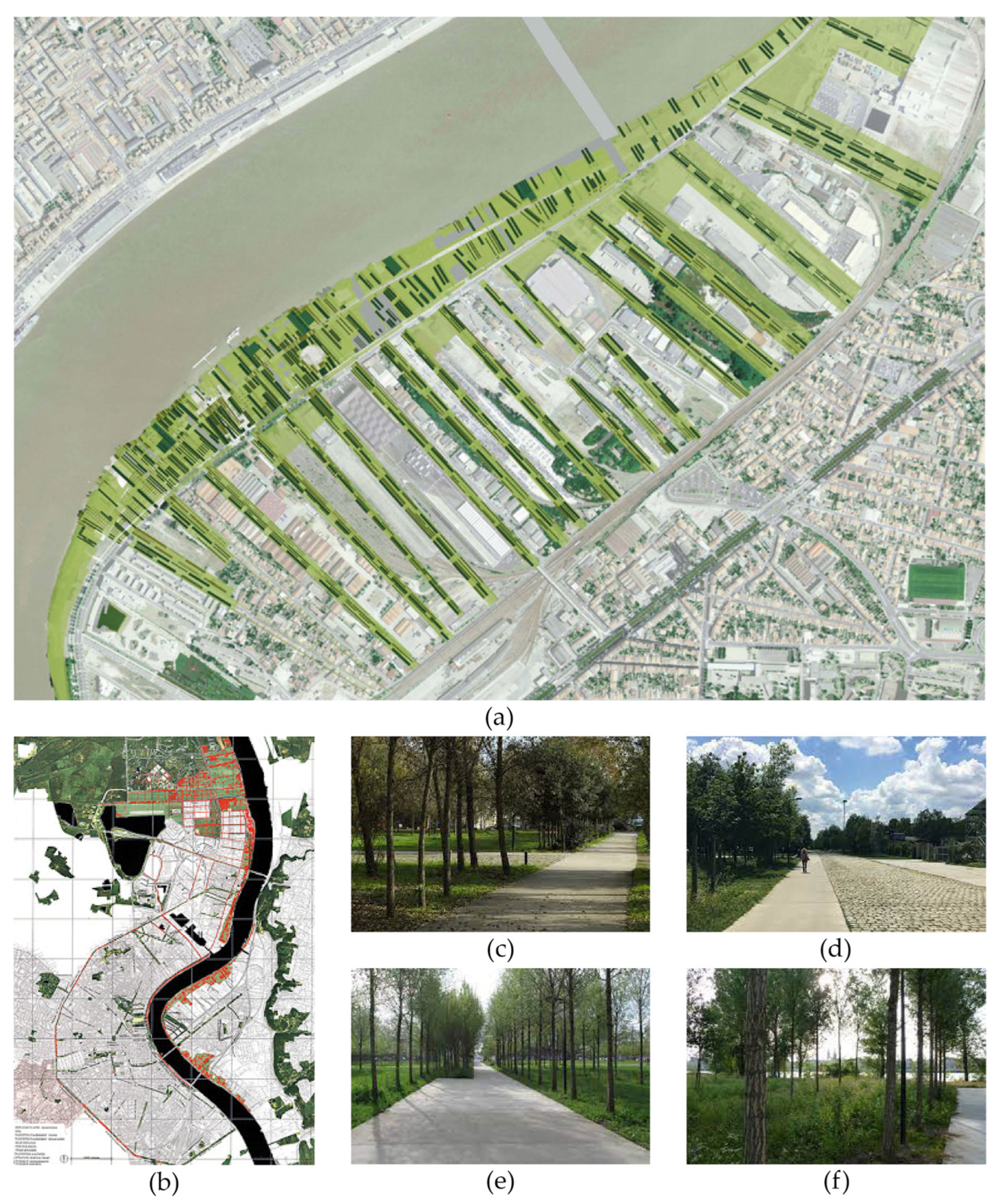
Parc aux Angéliques in Bordeaux, France, (Figure 5a) is an example of how overall spatial orientation and structures can be reused. The orientation of the former industrial grid-based plot structure is reused. Rows and small groves of trees are planted at irregular intervals and always follow the old industrial grid with long narrow plots aligned perpendicularly to the river. The flat riverbed is reused and most new paths and pavements are orientated according to the old industrial grid system.
In Alter Flugplatz Kalbach, near Frankfurt in Germany, the overall structure of the original airfield—runway, buildings, and pavements—was retained and slightly modified (Figure 4). This project also exemplifies direct reuse of materials. Half of the pavements were kept, and the other half broken into pieces of different sizes ranging from fine gravel to pebbles to huge 10 m2 concrete blocks (Figure 4b–e). Some of these were moved and stacked, others left on the spot, and all were kept within the boundaries of the site (Figure 4c). Alter Flugplatz Kalbach demonstrates new applications for the extensive hardscape. The airfield was opened to the public for recreational outdoor use. With few modifications, the huge, paved runway is reused for activities such as roller-skating, cycling or picnicking (Figure 4f). The buildings and the control tower are used for cafés, classrooms, and workshops. The open spaces and the buildings support events, festivals, nature laboratories, and picnic areas for the local district, and for the city of Frankfurt.
Located in northern France, the Louvre Lens Museum Park project investigates the geological and cultural layers of the landscape to reveal the long-hidden sources and places of industrial mining. The museum extends beyond the buildings and the park displays the structures and traces of the former industrial landscape, their uses and activities. The museum building and museum park are enclosed by a wall constructed of soil and limestone from the former mining industry that was dug up during the construction work on the museum foundation and basement (Figure 3b). Pebbles and coal residue from the mining industry are reused as part of the pavement (Figure 3g). Trees that had gradually colonised the mining site were kept and reused in the new park setting (Figure 3e). The park is accessible outside the museum’s opening hours and is a meeting place for the local residents and visitors, a space for cultural activities and a place to learn about the local industrial history.
Summing up, reuse can be understood and practised on different levels and scales ranging from overall structures to individual elements and materials to geological layers, including: 1. reuse of a region; 2. reuse of overall structures such as border/edge zone, infrastructure, road system, grid, plot structure, green structure, building structure, zones/subareas; 3. reuse of open spaces and spatial sequences; 4. reuse of specific structures such as buildings, foundations, terrain elements, plantings, roads, pavements, tracks, etc.; 5. reuse of materials on site: building materials, pavements, soil, stone, and concrete.
4.2. Porosity
The strategy porosity is about opening the area to the surroundings, breaking down internal barriers, and allowing for ease of passage, spaces for social interactions, and a sense of flow, while simultaneously making space for ecological systems and enabling multifunctional uses of the formerly monofunctional industrial areas. Porosity relies on democratic values about sharing resources and understanding landscapes and spaces as common ground where everyone has access. For example, pedestrians and non-motorised modes of transportation should be able to access all areas, and there should be spaces for different groups to meet and spend time.
The Louvre Lens Museum Park by the landscape architect Catherine Mosbach elegantly exemplifies porosity on different levels and scales (Figure 3). The park is placed on top of a horizontal slag heap from the former coalmine—elevated up to four metres above the surrounding town—and is criss-crossed by a network of former railway tracks which served the mining industry. The oblong area follows the course of the former railway tracks that ran east to west. Forest plantings in both the western and eastern ends of the park and shelterbelt plantings along the edge have colonised the former mining site (Figure 3e). Due to differences in terrain level and plantings due to nature succession, the former slag heap was previously experienced as an enclosed area. Mosbach has constructed an enclosing wall along the edge zone of the park (Figure 3b), yet she has also re-established connections on different levels, between the territory, the town, the park, the museum, and the subterranean history. Promenades from four main directions connect the territory and town with the Museum Park (Figure 3c) and 10 entrances punch holes in the edge zone that lead to and from the park. The park is open to the surrounding society as a local green area as well as a destination for guests and visitors travelling to the area. From the park, there is a visual connection to the massive twin slag heaps just outside Loos-en-Gohelle. Centred in the park is a square museum building with a pair of rectangular wings to the northwest and to the southeast (Figure 3a).
Both wings have slightly curved façades and are a bit displaced compared to the railway courses, mimicking four derailed train carriages. The buildings feature transparent glass roofs and façades, aluminium sheet panels that reflect the surroundings and emphasise the relationship between outside and inside, landscape, and building (Figure 3d,h). The Louvre Lens Museum Park addresses horizontal porosity. It also addresses vertical porosity and porosity in the literal sense of the word. Concrete pavement is punctured with round patches, cracks, and holes, especially concentrated around the building. Some holes and cracks are filled with porous materials left over from the mining industry or plants, which enable the filtration and storage of water (Figure 3g–j). A network of concrete paths winds throughout the park and around pre-existing trees, connecting the buildings and entrances, and providing a good means of getting around within the park. Vertical cuts were made in the slag heap to define or divide the area into zones (Figure 3f). The remoulding, cracks, and holes in the slag heap and pavements all provide spaces for recreational activities and spaces for relaxation (Figure 3h).
The regional network of pedestrian and cycling paths, the cleaning of the Emscher River, and the reconnection of fragmented green structures into the IBA Emscher Park makes the landscape more accessible to everyone and simultaneously benefits ecological systems. In Hersted Industripark, landscape architect Kristine Jensen has remoulded earthworks and opened plantings in the edge zone, creating and strengthening access and connections between the city and the industrial area to the forest Vestskoven, inviting people to rediscover and reclaim space. New paths and connections between the site, the river and the city have opened Alter Flugplatz Kalbach to the public for recreational outdoor uses. Perforations and the removal of extensive hardscape have made way for ecological systems, water collection, and vegetation.
The investigation of these five reference cases demonstrates how porosity can be understood and applied at various levels and scales. Points of attention: 1. social and ecological connections; 2. interpenetrations of physical edges and administrative borders; 3. circulation for pedestrians and cyclists; 4. open for new uses; 5. support common areas and facilities; 6. support places to stay.
4.3. Re-Naturing
Re-naturing, in the context of young industrial landscapes, refers to creating conditions and habitats that allow nature’s processes to unfold, and to restoring, maintaining, and reconnecting damaged and fragmented nature. Re-naturing aims, on the one hand, to restore the ecology of an area currently damaged by human activities, and on the other, to use that human intervention to help heal and re-enchant the human perception of nature by delaying the otherwise equalisation of differences that any natural succession brings about.
Formerly a US military air base, Alter Flugplatz Kalbach has been transformed by GTL Michael Triebswetter Landschaftsarchitekt into a site for outdoor recreation, and this project represents an informative re-naturing strategy (Figure 4). The area is surrounded by grassland, fields, the river Nidda, a wooded area, allotment gardens, and the urban area of Bonames, a quarter of Frankfurt am Main. The area is centred on the former long runway (Figure 4a). The area north of the runway is organised along the runway and zoned into: a maintenance and parking area, an area with the former military buildings, and the red and white chequered control tower, and a plantation area. South of the runway is an open floodplain and a path leading to the river. In Alter Flugplatz Kalbach, the pavement has been subject to greening. The runway material was fractioned into various sizes, ranging from gravel up to concrete clods of 10 m, and was used on site to create subareas with different habitat conditions. Ranging from a hard barren habitat to a climax forest, the former airfield shows different ecological potentials (a succession and monitoring area, a ruderal meadow area, a concrete slab field area, a concrete break-off area, Figure 4b–e,g). The site serves as an educational facility and a showcase for the ecological values of the area. Greening can be practised at different levels. The strategy for Emscher Landscape Park covers a huge area of diverse open spaces, including forests, agricultural land, brownfields, railways, embankments, and other greenish wastelands. The aim was/is to regenerate the landscape. New green areas along and across the Emscher valley were created and the fragmented green structure was connected to form green corridors that enhance biodiversity.
The remediation of water and soil through biological processes plays a major part in fulfilling the IBA Emscher Park mission of renewal. The Emscher River ecology was restored through the establishment of new sewers, wastewater treatments plants, and underground wastewater canals, and open water courses were re-natured (Figure 5d). In Parc aux Angéliques, the area was divided into smaller lots consisting of either higher woody plants, trees and groves, or lower grass and herbs or combinations of the two (Figure 5c–f). A huge number of trees were planted, and species chosen were mainly native (ash, maple, wild cherry, and hornbeam. The native herb, angelica, inspired the name of the park. The vegetation strategy for the Louvre Lens Museum Park also used the planting and sowing of trees, woody plants, grass, and herbs, but here and there, areas and surfaces were also left alone to enable natural succession. In Hersted Industripark, a new water management system was proposed. It consisted of remoulding existing ditches, and establishing new ditches and small wetlands (Figure 1a,f). Strategies for the greening of façades and roofs according to the different building typologies were seen in the proposal for Hersted Industripark (Figure 1a). Elaborate infiltration and storage of water were used in Louvre Lens Museum Park (Figure 3g). Here, holes filled with pebbles and coal-residue filtrated storm water into the ground [62].
The investigation of reference cases demonstrates how re-naturing is practised in different ways and on different scales. It addresses the following topics: 1. greening (establishing green areas and corridors, plantings, and/or natural succession, the greening of surfaces); 2. restoration of water courses and water management; 3. increase of biodiversity and biotopes; 4. remediation of soil, water, and air.
4.4. Open-Endedness
The strategy of open-endedness deals with flexibility, multiplicity, and temporality. Instead of fully completed projects that remain fixed, an open-ended approach takes place in incremental stages with gradual changes. The dynamic processes of nature and landscape are driven by human and non-human actors. This strategy acknowledges that the world is cyclical, that we are all connected, and that future generations will follow.
Parc aux Angéliques is an example of an open-ended and adaptive landscape-based transformation. The park is located in wine territory, in the city of Bordeaux, in a former military area called La Bastide, opposite the city centre on the right bank of the Garonne River. The park has evolved through a long planning process led by landscape architect firm Michel Desvigne Paysagiste, involving the formulation of landscape guidelines, charters, and plans for Bordeaux before proposing the strategy for the park (Figure 5a,b). The park area stretches 3.5 km along the edge of the Garonne River between the two bridges Pont de Pierre and Pont Jacques Chaban Delmas. To the west, the park is bound by the riverbank. To the east, is an industrial and commercial area under transformation bound by old railway tracks. The elongated park varies in width and contains fringe areas perpendicular to the riverbank that extend into the hinterland. A spatial structuring grid supports the adaptive strategy of Parc aux Angéliques. Most paths, plantings, and pavements are in perpendicular alignment with the river. Groves and rows of trees of various species and heights are planted in irregular intervals, yet are always in perpendicular alignment with the river (Figure 5a,e,f). The variation of heights of the trees and vegetation emphasise the change of seasons and thus the passing of time. Rows of trees and groves lead people towards the river and frame different views. This spatial strategy allows for more diverse constructions and buildings in the future. The park is a result of a long-term process-oriented planning process that acknowledges the uncertainty of the future and enables continuous incremental interventions. Along the way, the strategy has proved suitable for building on and absorbing existing and new developments and green areas. For instance, the Jardin Botanique has been incorporated into the spatial strategy as a green area extending into the hinterland. The strategy also extends to the north along the river in Quartier Bastide Brazza Nord.
Instead of a definite design, the proposal for Hersted Industripark divides the YIL into flexible and diverse quarters, and suggests strategies for future buildings inspired by existing building typologies, orientation, and scale. Both Parc aux Angéliques and Hersted Industripark represent spatially based open-ended strategies, whereas IBA Emscher Park expresses a programmatically open-ended strategy. In addition to the overall regional initiatives, the Emscher Landscape Park strategy served as an open vision based on guidelines and realised through 117 smaller projects. The Louvre Lens Museum Park represents open-endedness on a comparatively minor scale. Here, the cracks in the pavement, walls, and terrain elements are left uncovered and open, allowing random vegetation to grow. The park is designed to evolve over time and thereby reveal the processes and dynamics of nature through erosion, weathering, and natural succession.
This study of the reference cases revealed how open-endedness can be understood and supported at different levels. It addressed the following focus points: 1. long-term planning and long-term cultivation; 2. programmatic open-ended strategy; 3. adaptable spatial strategy; 4. overall vision implemented through subprojects.
5. Discussion
Through the literature review, conducted along with the screening of projects and case studies, we have identified the four guiding strategies that are useful in transformation processes shaped by the existing urban landscape and its site features. We selected five cases based on their ability to demonstrate landscape-based transformation of young post-industrial landscapes. The examination of these cases revealed different examples of the transformation of industrial areas based on the landscape and its various features. In the following, we will discuss their qualities and relevance regarding transformation of large-scale YILs.
5.1. Spatial, Complementary, Multi-Scalar, and Temporal Strategies
The four landscape-based strategies of reuse, porosity, re-naturing, and open-endedness partly correspond one to one with the presented four theoretical perspectives: the heritage perspective, the socio-cultural use perspective, the environmental and ecological perspective, and the processual and cyclical perspective. There is congruence but also overlap between strategies and perspectives. Each strategy comprises site features or landscape characteristics and entails spatial, complementary, multi-scalar, and temporal aspects.
When considering the benefits of landscape-based transformation projects and the strategies from a spatial point of view, it is important to note that the strategies do not replace spatial analyses and spatial strategies as such. The strategies should be understood as a set of qualifying lenses through which we focus on specific aspects of the landscape, its site features and materials, and so that they might guide site-informed transformation. Since reuse can happen on multiple scales, the spatial aspects of the reuse strategy are open to interpretation. Reuse can span from large-scale structures and elements to materials on site that can be redistributed, to industrial areas, and even to regions. Entanglements of new and old structures and materials can contribute to diverse spatial experiences. Porosity represents a spatial quality that allows for accessibility and flow. Plantings can create spaces that provide shelter, reflect the seasons, and the passage of time. Re-naturing and open-endedness hold spatial potentials as well as spatial constraints. Re-naturing potentials can be thought of in terms of enhancing the natural flux through plantings and hydrological structures, and its constraints in terms of maintaining the same structures in the future uses of the sites.
All cases include all four strategies to various degrees. However, this investigation does not offer a basis for assessing which one of the four strategies is the most relevant in a specific transformation process and context. The guiding strategies can be considered rhetorical concepts, each of them addressing spatial aspects of ethical requirements and influencing how to bring the strategies to life. As such, they are not exclusive to one another; on the contrary, they may overlap and enhance one another, depending on how they materialise in the specific contexts. Although the strategies and philosophical worldviews behind are complementary and they all share democratic and sustainable values for present and future generations, they are not always in mutual sympathy and may sometimes weaken one another. For instance, new passages, functions, and activities contributing to a greater number of people in an area could also cause disturbances with regard to wildlife and biodiversity. Additionally, reused structures and elements could be weathered and levelled out by the re-naturing processes, thus causing loss of local history and identity. The transformation of individual YILs and the choice of strategies are highly contextual and must be negotiated and weighed against each other, the specific landscape, and the local societal needs. We are aware that these four strategies must allow for a broad interpretational margin. None of the strategies stand alone, and they may be complementary with the other strategies.
The examination of strategies through these cases shows that they are all highly multi-scalar, ranging from the reuse of an entire industrial region in the Ruhr district to the on-site reuse of granulated concrete material from the runway in Alter Flugplatz Kalbach. Porosity in the Ruhr district is implemented in terms of re-establishing regional links and access between previously industrial regions, and in the Louvre Lens Museum Park in terms of subterranean pebbles and residue of limestones, siltstones, and scoria from the mining industry and construction work are reused as building materials and to retain water. Re-naturing and greening through tree plantings has taken place on a major urban scale in the industrial harbour front Parc aux Angéliques in Bordeaux, and in the form of natural succession on a minor scale in Alter Flugplatz Kalbach.
All strategies prescribe both temporal, processual, and change dimensions. This is most obviously embedded in the open-ended strategy, yet also evident in the reuse strategy, in which something existing is used again or in a new way. The re-naturing strategy also indicates the quality of timeliness in transforming conditions caused by humans back to a more natural state. Porosity does not indicate timeliness, process, or change aspects in itself, yet the existence of void spaces enables exchanges between people, living organisms, and substances. Thereby porosity indirectly also relates to timeliness, process or change. From thought to materialisation, the design process is often iterative; traditionally, it leads to a definitive static product. What is noteworthy is that all these proposed strategies contain temporal aspects that challenge the traditional design epistemology, taking it in a direction that is less static and more cyclical.
5.2. Relevance of the Landscape-Based Strategies in Relation to YILs
The transformation of YILs in Copenhagen involves facing challenges concerning reuse, including: gradual transformation (because some buildings are empty while others are still in use); uncertainty (because of the ownership structure); environmental legislations that complicate conversion, and risk of flooding (because of large, paved areas). This investigation suggests that these four guiding strategies are relevant in the transformation processes of YILs in Copenhagen. Addressing multi-scalar, spatial, and temporal aspects, these guidelines for transformation support the strategic potentials of YILs to become spaces of response to environmental and societal challenges.
The reuse strategy is highly relevant due to the great number of Copenhagen YILs, their expanse, and the associated elements, materials, and structures. This refers to the reuse of articulated edge zones, building elements, planting strategies, and the overall grid. As a strategy, porosity can contribute to the reintegration of YILs into the surrounding urban or suburban context. Connections between and interpenetrations of physical, municipal, and administrative boundaries support social and ecological networks, and enable multifunctional uses. The re-naturing of YILs could comprise of restoring, remediating, and managing processes of water and soil as well as increasing and establishing plantings and introducing green corridors, roofs, façades, and other areas. Open-endedness has potential in these contexts. The structural simplicity of many YILs in Copenhagen allow for further elaborations over time. As the potentials gradually become exhausted, constraints emerge. A form of dismantling could take place, opening space for new options to be considered and made manifest.
The Copenhagen YILs, and their strategic localisation along a new light rail represents a potential for a comprehensive plan for the region. Planned together, there is potential for solving general regional problems related to biodiversity, the climate catastrophe, food supplies, and the potential to develop sustainable districts in the Copenhagen suburbs that improve quality of life. The landscape-based transformation of the YILs represents an example of the complexities in this field. We assert that master planning must give way to more open-ended strategic landscape planning.
5.3. Transferable Knowledge
The literature review, the initial screening, and case study of the five projects indicate that the transformation of post-industrial and similar sites is an ongoing development.
We included cases with spatial characteristics and features similar to those of YILs and focused on landscape-based perspectives and strategies from North America and especially from Europe. We anticipate that our findings are relevant and transferable to transformation processes of YILs or other post-industrial landscapes in Europe and, to a lesser extent, in North America. We have not yet studied nor found studies of YILs or landscape-based transformation approaches to YILs in Asia, Africa, or South America. This needs to be further investigated to understand if our results are applicable in these contexts. The five projects selected are all categorised as urban environments in cities of different sizes and situated at various locations within the cities (harbour, inner city, the edge of the city/suburb). The cases represented a variety of geography, scale, and setting in an urban environment as well as a range of approaches to landscape-based transformation. The four landscape strategies could inspire and provide guidance to planners, landscape architects, and urban designers working with other types of industrial sites or in similar urban landscapes.
Although the cases covered a range of scales, they all encompassed a larger coherent area (7.7–80,000 hectares). The guiding strategies presented are all multi-scalar and, in our estimation, could be applied on a smaller scale to transform individual plots within young post-industrial landscapes anywhere.
6. Conclusions
Young industrial landscapes (dating roughly from the 1930s to the 1970s) are an omnipresent phenomena in Europe and beyond, and they are currently due for redevelopment in many countries. Knowledge of transformation practices as an alternative to both tabula rasa and green field practices, as well as propositions for strategies addressing what is on site are therefore much needed.
Based on our exploration of state-of-the-art literature on transformation of post-industrial landscapes and specific transformation projects, we identified four site-informed, i.e., landscape-based perspectives and related philosophical worldviews to be essential drivers for the transformation processes and results: 1. a socio-cultural user perspective, emphasising multifunctionality as a basic need in the transformed areas; 2. a heritage perspective, questioning and furthering understanding, and use of heritage in the transformation processes; 3. an environmental and ecological perspective acknowledging the need for including green and blue infrastructure in the transformed areas, and 4. a processual and cyclical perspective, which understands humans as dependent on the planet, ecosystems to be continuously developing, and also a perspective that acknowledges the uncertainty of the future.
As a response to these values and drivers, and based on an investigation of existing practices, we examined, and demonstrated four guiding strategies for landscape-based transformation: 1. reuse of site features such as materials, elements, structures, and spaces. 2. porosity reconnects the landscape to the surrounding urban context and deepens ecological structures to support accessibility, flow, and multifunctional uses; 3. re-naturing establishes and increases green surfaces, areas, networks, and corridors, and it works by restoring, remediating and managing site features, and deep ecological structures. Finally, 4. programmatic and spatial open-endedness help in implementing landscape strategies that are adaptable, comprehensive, incrementally long-term, and ongoing.
The strategies provide a much-needed set of values and instruments for redeveloping Copenhagen YILs and similar Danish YILs in order to better address social challenges. As these four strategies address site features on multiple levels with regard to space, scale, and time, they are complementary and will often be applied to transformation projects simultaneously. The variety of cases in which we found these strategies active promises a broad range of generalisability and transferability of the results.
Author Contributions
Conceptualization, J.H., E.M.B. and G.J.; methodology, J.H., E.M.B. and G.J.; validation, J.H.; formal analysis, J.H.; funding acquisition, J.H.; investigation, J.H.; writing—original draft, J.H.; writing—review and editing, J.H., E.M.B. and G.J.; visualization, J.H.; supervision, E.M.B.; project administration, J.H. All authors have read and agreed to the published version of the manuscript.
Funding
This research received no external funding.
Institutional Review Board Statement
Not applicable.
Informed Consent Statement
Not applicable.
Data Availability Statement
Not applicable.
Conflicts of Interest
The authors declare no conflict of interest.
References
- Leboutte, R. A space of European de-industrialisation in the late twentieth century: Nord/Pas-de-Calais, Wallonia and the Ruhrgebiet. Eur. Rev. Hist. 2009, 16, 755–770. [Google Scholar] [CrossRef] [Green Version]
- Loures, L.; Panagopoulos, T. Reclamation of Derelict Industrial Land in Portugal: Greening is not Enough. Int. J. Sustain. Dev. Plan. 2010, 5, 343–350. [Google Scholar] [CrossRef] [Green Version]
- De Sousa, C.A. Turning brownfields into green space in the City of Toronto. Landsc. Urban Plan. 2003, 62, 181–198. [Google Scholar] [CrossRef]
- Green Paper: Urban Environment; Commission of the European Communities: Brussels, Belgum; Luxemburg, 1991.
- Bauman, Z. Liquid Modernity; Wiley: Oxford, UK, 2013. [Google Scholar]
- The HUL Guidebook: Managing Heritage in Dynamic and Constantly Changing Urban Environments; A Practical Guide to UNESCO’s Recommendation on the Historic Urban Landscape; World Heritage Institute of Training and Research for the Asia and the Pacific Region: Bad Ischl, Austria, 2016.
- Loures, L. Post-industrial landscapes as drivers for urban redevelopment: Public versus expert perspectives towards the benefits and barriers of the reuse of post-industrial sites in urban areas. Habitat Int. 2015, 45, 72–81. [Google Scholar] [CrossRef]
- De Sousa, C. The greening of urban post-industrial landscapes: Past practices and emerging trends. Local Environ. 2014, 19, 1049–1067. [Google Scholar] [CrossRef]
- Braae, E. Beauty Redeemed: Recycling Post-Industrial Landscapes; IKAROS Press: Risskov, Denmark, 2015. [Google Scholar]
- Braae, E.; Diedrich, L. Site specificity in contemporary large-scale harbour transformation projects. J. Landsc. Archit. 2012, 7, 20–33. [Google Scholar] [CrossRef] [Green Version]
- Riesto, S. Biography of an Industrial Landscape: Carlsberg’s Urban Spaces Retold; Amsterdam University Press: Amsterdam, The Netherlands, 2018. [Google Scholar]
- Storm, A. Post-Industrial Landscape Scars; Palgrave Macmillan: New York, NY, USA, 2014. [Google Scholar]
- Kirovová, L.; Sigmundová, A. Implementing an Ecosystem Approach to The Adaptive Reuse Of Industrial Sites. WIT Trans. Built Environ. 2014, 142, 433. [Google Scholar] [CrossRef] [Green Version]
- Pietta, A.; Tononi, M. Re-Naturing the City: Linking Urban Political Ecology and Cultural Ecosystem Services. Sustainability 2021, 13, 1786. [Google Scholar] [CrossRef]
- Mortensen, L.R.; Braae, E. The Commonplace as Herritage—Younger Industrial Landscapes. Nord. J. Archit. Res. 2017, 29, 157–184. [Google Scholar]
- Heesche, J.; Braae, E.; Jørgensen, G. Typologising site-specific features in young industrial landscapes. Landsc. Res. 2022. (in review) [Google Scholar]
- Mortensen, L.R. Transformation af Efterkrigstidens Industrilandskaber [Transformation of Post-War Industrial Landscapes]. Ph.D. Thesis, Institut for Bygningskunst; Det Kongelige Danske Kunstakademis Skoler for Arkitektur; Design og Konservering, Copenhagen, Denmark, 2016. [Google Scholar]
- Jensen, B.B. Industriarkitektur efter industrialismen 1960–1980 [Industrial architecture after industrialism 1960–1980] In Industri-Arkitektur; Høyer Mikkelsen, H., Birket-Smith, T., Høgfeldt Hansen, L., Eds.; Arkitekturforlaget B: Copenhagen, Denmark, 2010. [Google Scholar]
- Mortensen, M.T. Industrikvarterer i forandring 1935–2015 [Developments in industrial areas 1935–2015]. Factory & Dwelling—The Industrial Heritage of the Nordic Countries. 2012, pp. 14–35. Available online: https://kroppedal.dk/wp-content/uploads/2013/08/FB2012.industriforandring.pdf (accessed on 29 April 2022).
- Pedersen, M. Velfærdsstatens Industrilandskab: Om Efterkrigstidens Industrikvarterer i Nordjylland: En Forskningsrapport [Industrial Landscapes of the Welfare State—On Post-War Industrial Areas in Northern Jutland]; Aalborg Universitetsforlag: Aalborg, Denmark, 2010. [Google Scholar]
- Furlan, C. On Worn Out Landscapes. Mapping Wasteland in the Charleroi and Veneto Central Territories. Ph.D. Thesis, KU Leuven, Leuven, Belgum, 2017. [Google Scholar]
- Britta Hüttenhain, A.I.K. City and Industry: How to Cross Borders? Learning From Innovative Company Site Transformations. Urban Plan. 2021, 6, 368–381. [Google Scholar] [CrossRef]
- Ryckewaert, M.; Zaman, J.; De Boeck, S. Variable Arrangements Between Residential and Productive Activities: Conceiving Mixed-Use for Urban Development in Brussels. Urban Plan. 2021, 6, 334–349. [Google Scholar] [CrossRef]
- Berger, A. Drosscape: Wasting Land Urban America; Princeton Architectural Press: New York, NY, USA, 1998. [Google Scholar]
- Scheer, B.C.; Petkov, M. Edge City Morphology: A Comparison of Commercial Centers. J. Am. Plan. Assoc. 1998, 64, 298–310. [Google Scholar] [CrossRef]
- Hansen, K.E.; Bech-Danielsen, C. Attraktive Friarealer i Erhvervsområder: Gennem Offentligt og Privat Samarbejde [Attractive Open Spaces in Business Areas: Public and Private Cooperation]; Socialministeriet: Copenhagen, Denmark, 2008. [Google Scholar]
- Gerring, J.; Cojocaru, L. Selecting Cases for Intensive Analysis: A Diversity of Goals and Methods. Sociol. Methods Res. 2016, 45, 392–423. [Google Scholar] [CrossRef]
- Corner, J. Terra Fluxus. In Landscape Urbanism Reader; Waldheim, C., Ed.; Princeton Architectural Press: New York, NY, USA, 2006. [Google Scholar]
- Spirn, A.W. Ecological Urbanism: A Framework for the Design of Resilient Cities (2014); Island Press/Center for Resource Economics: Washington, DC, USA, 2013; pp. 557–571. [Google Scholar]
- Sijmons, D. In the Anthropocene, Site Matters in Four Ways. In Site Matters: Strategies for Uncertainty Through Planning and Design; Kahn, A., Burns, C.J., Eds.; Taylor & Francis Group: Milton, ON, Canada, 2020. [Google Scholar]
- Lynch, K. Wasting Away; Sierra Club Books: San Francisco, CA, USA, 1990. [Google Scholar]
- Antrop, M. Why landscapes of the past are important for the future. Landsc. Urban Plan. 2005, 70, 21–34. [Google Scholar] [CrossRef]
- Way, T. Landscapes of industrial excess: A thick sections approach to Gas Works Park. J. Landsc. Archit. 2013, 8, 28–39. [Google Scholar] [CrossRef]
- Snep, R.; Van Ierland, E.; Opdam, P. Enhancing biodiversity at business sites: What are the options, and which of these do stakeholders prefer? Landsc. Urban Plan. 2009, 91, 26–35. [Google Scholar] [CrossRef]
- Snep, R.P.H.; WallisDeVries, M.F.; Opdam, P. Conservation where people work: A role for business districts and industrial areas in enhancing endangered butterfly populations? Landsc. Urban Plan. 2011, 103, 94–101. [Google Scholar] [CrossRef]
- Mallo, D.; Schoneboom, A.; Tardiveau, A.; Vigar, G. From non-place to place in post-suburbia: City-edge office parks as loci for nature-based micro-interventions. J. Environ. Plan. Manag. 2020, 63, 2446–2463. [Google Scholar] [CrossRef]
- Sharma, A. Landscape of Industry: Transformation of (Eco) Industrial Park through history. J. Arts Humanit. 2013, 2, 1–9. [Google Scholar] [CrossRef]
- Heatherington, C. Revealing Change in Cultural Landscapes: Material, Spatial and Ecological Considerations; Routledge, Taylor & Francis Group: London, UK, 2021. [Google Scholar]
- Loures, L.; Panagopoulos, T. Sustainable Reclamation Of Industrial Areas In Urban Landscapes. WIT Trans. Ecol. Environ. 2007, 102, 791–800. [Google Scholar] [CrossRef] [Green Version]
- Furlan, C. After Tomorrow: Three Perspectives on Urban Wastelands. In The Horizontal Metropolis Between Urbanism and Urbanization; Springer: Berlin/Heidelberg, Germany, 2018; pp. 321–329. [Google Scholar] [CrossRef]
- Hauxner, M. Tegning og Læsning, Videnskab og Kunst, Teori og Metode, Rum og Værker [Drawing and Reading, Science and Art, Theory and Method, Space and Works]; DSR Forlag: København, Denmark, 2001. [Google Scholar]
- Benjamin, W. Reflections: Essays, Aphorisms, Autobiographical Writings; Schocken Books: New York, NY, USA, 1986. [Google Scholar]
- Wolfrum, S. Porous City: From Metaphor to Urban Agenda; Birkhäuser: Basel, Switzerland, 2018. [Google Scholar]
- Vigano, P. The Metropolis of the Twenty-First Century. The Project of a Porous City. OASE 2009, 80, 91–107. [Google Scholar]
- Braae, E.M. Approaching the ‘As Found’. Pamplet Delta Dialogues 2017, 20, 46–59. [Google Scholar]
- Ahern, J. Urban landscape sustainability and resilience: The promise and challenges of integrating ecology with urban planning and design: Key Concepts and Research Priorities for Landscape Sustainability. Landsc. Ecol. 2013, 28, 1203–1212. [Google Scholar] [CrossRef]
- Fairclough, G. New heritage frontiers. In Heritage and Beyond; Council of Europe Publishing: Strasbourg, France, 2009; pp. 29–41. [Google Scholar]
- Smith, L. Uses of Heritage; Routledge: London, UK, 2006. [Google Scholar]
- Koolhaas, R. Preservation is Overtaking Us. Future Anterior 2004, 1, xiv-3. [Google Scholar]
- Hutton, J. Reciprocal landscapes: Material portraits in New York City and elsewhere. J. Landsc. Archit. 2013, 8, 40–47. [Google Scholar] [CrossRef]
- Chowdhury, S.; Kain, J.-H.; Adelfio, M.; Volchko, Y.; Norrman, J. Greening the Browns: A Bio-Based Land Use Framework for Analysing the Potential of Urban Brownfields in an Urban Circular Economy. Sustainability 2020, 12, 6278. [Google Scholar] [CrossRef]
- Doick, K.J.; Sellers, G.; Hutchings, T.R.; Moffat, A.J. Brownfield Sites Turned Green: Realising Sustainability In Urban Revival. WIT Trans. Ecol. Environ. 2006, 94, 10. [Google Scholar] [CrossRef] [Green Version]
- Schilling, J.; Logan, J. Greening the Rust Belt: A Green Infrastructure Model for Right Sizing America’s Shrinking Cities. J. Am. Plan. Assoc. 2008, 74, 451–466. [Google Scholar] [CrossRef]
- Siikamäki, J.; Wernstedt, K. Turning Brownfields into Greenspaces: Examining Incentives and Barriers to Revitalization. J. Health Politics Policy Law 2008, 33, 559–593. [Google Scholar] [CrossRef] [Green Version]
- Erdem, M.; Nassauer, J.I. Design of Brownfield Landscapes Under Different Contaminant Remediation Policies in Europe and the United States. Landsc. J. 2013, 32, 277–292. [Google Scholar] [CrossRef]
- Bartolini, N.; DeSilvey, C. Making space for hybridity: Industrial heritage naturecultures at West Carclaze Garden Village, Cornwall. Geoforum 2020, 113, 39–49. [Google Scholar] [CrossRef]
- McHarg, I.L. Design with Nature, 2nd ed.; The Natural History Press: Garden City, NY, USA, 1969. [Google Scholar]
- Beatley, T.; Newman, P. Biophilic Cities Are Sustainable, Resilient Cities. Sustainability 2013, 5, 3328–3345. [Google Scholar] [CrossRef] [Green Version]
- Waldheim, C. Landscape as Urbanism: A General Theory; Princeton University Press: Princeton, NJ, USA, 2016. [Google Scholar]
- Marot, S. The Reclaiming of Sites. In Recovering Landscape: Essays in Contemporary Landscape Architecture; Corner, J., Ed.; Princeton Architectural Press: New York, NY, USA, 1999; pp. 45–57. [Google Scholar]
- Langhorst, J.W. Re-covering landscapes: Derelict and abandoned sites as contest terrain. Icon 2004, 10, 65–79. [Google Scholar]
- Santiago, V.Z. A collection of stories: Euralens Centralité and the Louvre-Lens Museum Park. J. Landsc. Archit. 2015, 10, 44–57. [Google Scholar] [CrossRef]
Figure 1.
Hersted Industripark. Location: Albertslund, Copenhagen capital area (DK). Architects/Consultants: Arkitekt Kristine Jensens Tegnestue, SLETH, and Norconsult. Client: Albertslund Municipality and Realdania. Designed: 2012–2013. Construction: Ideas implemented in later plans. Size: 160 hectares. Type of plan: Invited competition (1st prize). Type of transformation: Young industrial landscape into sustainable business area. (a) Overall concept showing new wetlands, openings in the earthworks, combination of new and old reused buildings, green roofs; (b) The area is connected with the context; (c) Blue and green connections established by reuse of existing boulevards and leftover spatial voids; (d) The area divided into zones based on existing building typology, grid, and scale; (e) Green connection; (f) Green connection meeting the surroundings. © All drawings and illustrations by Arkitekt Kristine Jensens Tegnestue, SLETH, and Norconsult, 2013.

Figure 2.
IBA Emscher Park. Location: Ruhrdistrict (DE). Initiator: The state of North Rhine-Westphalia. Coordinator: IBA Association. Planned: 1989–1999. Construction: Realised through smaller sub-projects, for instance, Duisburg Nord Landscape Park and Zeche Zollverein. Size: sub-projects covering over 80,000 hectares. Type of plan: Regional strategy. Type transformation: 150 old degraded industrial brownfield into green lively region. (a) Overall strategy for IBA Emscher Park, © Regio-nalverband Ruhr (RVR); (b) Path on reused railway tracks in Zeche Zollverein; (c) Path on reused railway tracks in Duisburg Nord Landscape Park; (d) Theme garden in Duisburg Nord Landscape Park; (e) Overgrown built structures in Duisburg Nord Landscape Park; (f) Emscher River in Duisburg Nord Landscape Park; (g) Piazza Metallica in Duisburg Nord Landscape Park. © All photos by Ellen Marie Braae, 2017.

Figure 3.
Louvre Lens Museum Park. Location: Lens, North Pas de Calais (FR). Landscape architect: Mosbach Paysagistes. Architect: SANAA. Client/Developer: North Pas de Calais, Region. Designed: 2003. Construction: 2005–2013. Size: 25 hectares. Type of plan: Architectural competition (1st prize). Type of transformation: Former mining area into Museum Park. (a) Plan of park, central museum building and wings, and the surrounding city, © Mosbach Paysagistes and Sanaa; (b) Wall of subterranean materials excavated from the construction work of museum; (c) Promenade connect museum, park and city; (d) Aluminium façades mirror the surrounding park; (e) Colonised forest plantings; (f) Vertical cut in slag heap define a smaller area; (g) Round holes in pavement filled with porous materials; (h) Remoulding of surface to create holes to retain water and mound for sitting. Transparent glass façades mirror park in the background; (i) Cracks and plantings in pavement; (j) Meeting between different surfaces. © All photos by Catherine Mosbach, Mosbach Paysagistes.

Figure 4.
Alter Flugplatz Kalbach. Location: Frankfurt am Main/Bonames, (DE). Landscape architect: GTL Michael Triebswetter Landschaftsarchitekt. Client: Grünflächenamt Frankfurt a.m. Designed: 2002. Construction: 2003–2004. Size: 7.7 hectares. Type of transformation: US military air base from (1951–1952) into site for outdoor recreation. (a) Plan of transformed airport with long runway and subareas along the river Nidda; (b) Pioneer forest; (c) Area with broken up and stacked concrete pavement; (d) Square slabs of old concrete pavement; (e) New wetland area; (f) Old runway used for new purposes; (g) Reused pavement and pioneer plants. © Drawing and photos by GTL Michael Triebswetter Landschaftsarchitekt.

Figure 5.
Parc aux Angéliques. Location: Bordeaux, Along Bordeaux’s right bank (FR). Landscape architect: Michel Desvigne Paysagiste (MDP). Client: The City of Bordeaux. Construction: 2012–ongoing. Size: 75 hectares. Type of plan: Plan commissioned by the City of Bordeaux. Type of transformation: Harbour into green park for outdoor recreation, 2012. (a) Plan of park with plantings and paths along former long narrow plots, © Drawings by Michel Desvigne Paysagiste, MDP; (b) Plan guide/landscape strategy for Bordeaux, 2005, © Drawings by Michel Desvigne Paysagiste, MDP; (c) Grid of paths and roads along river and new transversal paths leading to the river, © Photo by Guillaume Leuregans; (d) New path along reused cobbled road, © Photo by Michel Desvigne Paysagiste, MDP; (e) Rows of trees along long straight path, © Photo by Guillaume Leuregans; (f) Grooves with lower herbs and plants underneath along path leading towards the river, © Photo by Guillaume Leuregans.

Publisher’s Note: MDPI stays neutral with regard to jurisdictional claims in published maps and institutional affiliations. |
© 2022 by the authors. Licensee MDPI, Basel, Switzerland. This article is an open access article distributed under the terms and conditions of the Creative Commons Attribution (CC BY) license (https://creativecommons.org/licenses/by/4.0/).
Share and Cite
MDPI and ACS Style
Heesche, J.; Braae, E.M.; Jørgensen, G. Landscape-Based Transformation of Young Industrial Landscapes. Land 2022, 11, 908. https://0-doi-org.brum.beds.ac.uk/10.3390/land11060908
AMA Style
Heesche J, Braae EM, Jørgensen G. Landscape-Based Transformation of Young Industrial Landscapes. Land. 2022; 11(6):908. https://0-doi-org.brum.beds.ac.uk/10.3390/land11060908
Chicago/Turabian StyleHeesche, Johanne, Ellen Marie Braae, and Gertrud Jørgensen. 2022. "Landscape-Based Transformation of Young Industrial Landscapes" Land 11, no. 6: 908. https://0-doi-org.brum.beds.ac.uk/10.3390/land11060908
Note that from the first issue of 2016, this journal uses article numbers instead of page numbers. See further details here.