Article

Assessing the Effectiveness of Administrative District Realignments Based on a Geographically and Temporally Weighted Regression Model

1
School of Government, Liaoning Normal University, Dalian 116029, China
2
School of Geographical Sciences, Liaoning Normal University, Dalian 116029, China
3
Department of Resource Ecology and Biological Resources, Institute of Geographic Sciences and Natural Resources Research, Chinese Academy of Sciences, Beijing 100101, China
*
Author to whom correspondence should be addressed.
Submission received: 20 June 2022 / Revised: 19 July 2022 / Accepted: 20 July 2022 / Published: 22 July 2022
(This article belongs to the Topic Climate Change and Environmental Sustainability)

Abstract

:
The long-term effects of administrative division adjustments on economic development in Dalian City, China, is presently unclear. Therefore, we employed a geographically and temporally weighted regression model to construct an index assessment system using the annual number of newly registered enterprises as the dependent variable. We empirically studied the effects of administrative division adjustments of townships in Dalian City from 2010 to 2020. The results showed that: (i) adjustments in townships administrative divisions negatively affected regional enterprise concentrations and economic development in general, whereas industrial and transportation factors demonstrated positive effects to variable degrees, and the effects of policy, location, and population factors were not significant. (ii) Over time, the effects of townships administrative division adjustments changed from positive to negative, and the negative effects displayed an increasing trend, revealing that (iii) the effect of administrative division adjustments in Dalian City was positive and negative over time. This further reveals the objective problem that administrative division adjustment in recent years was effective over the short term, but not over the long term. (iv) During the study period, administrative division adjustments positively affected regional enterprise concentrations and economic development solely during a short time frame and in a small geographical area. However, its negative effects increased extensively, which infers that maintaining a relatively stable administrative division is more beneficial for promoting economic development in Dalian City.

1. Introduction

Administrative division systems from a regional division system implemented by the state for hierarchical management [1] are closely related to economic, social, political, and other factors. To promote rapid economic and social development, the government administrative division system must be continuously optimized and improved [2]. The adjustment of administrative divisions is an important means for the central government to achieve optimal governance of land space through the merger and division of administrative divisions, affiliation changes, administrative-level changes, and administrative boundary adjustments. Due to the rapid development of urbanization in western countries after World War II, urbanization reached its peak. Theoretical and practical research on administrative division adjustment in western countries focused on the spatial governance of urban administrative areas. The “giant government theory” states that under the traditional urban autonomy model, the division of government powers, management authority, and boundaries in urban areas proliferates. Fragmentation in the quantity and overlapping of geographical functions has further materialized. This has caused problems, such as racial-spatial segregation, uneven financial distribution, and confusion in government responsibilities, which should be integrated under a unified metropolitan area government [3]. However, the governance model of the metropolitan area has problems, such as the weakening of the prestige and status of the central city, low economic benefits in the suburbs, and a large disparity in taxation and public services between districts [4]. In recent years, the two-level management system of “city government + metropolitan area government” has become representative of the management model of metropolitan areas in western countries [5,6]. The adjustment of administrative divisions has a great impact on the equalization of public services and urban economic development [7,8]. Through the optimization of grassroots administrative districts, smaller administrative district units are merged into larger administrative district units, and large administrative district units are split into several smaller administrative district units. This enables local governments to provide better public services, save government administrative costs, improve administrative efficiency, and exert economies of appropriate scale. In this context, some scholars have suggested reduced levels across the U.S. government, function changes, and lower speeds in the adjustment and reform of administrative divisions [9].
With the deepening of marketization, decentralization, and globalization, Chinese cities have further undergone social and economic restructuring, similar to those in Western countries [10]. “The government plays a leading role in urbanization” is an important feature that distinguishes China from Western countries [1]. Since its reform and opening up, China has been undergoing a rapid economic and social transition period. Moreover, the rapid expansion of urban space [11,12] and the transformation and development of rural revitalization [13] have put forward urgent requirements for the development of urban sustainability [14] and regional integration [15]. For China, being in the transitional period, the adjustment of administrative divisions is a process of re-territorialization led by the government [16] and an important means of adjusting the spatial structure of cities and regions. Through the adjustment of administrative divisions, it is possible to change the rank and spatial order relationship between administrative regions, as well as the jurisdictional range and resource allocation capacity of an administrative region, exerting a direct effect on the regional development pattern [17]. China has carried out a series of administrative division adjustments of different scales and types in different levels of administrative regions [18], with several successful outcomes. For example, Zhejiang Province has attempted various adjustment methods since its reform and clearance, which has ensured a shift in the focus of the country’s development strategy and the continued development of urbanization [19]. Guangzhou has successfully changed its future developmental direction by adjusting its administrative divisions [20]. The adjustments in townships administrative divisions in Henan Province have been an obvious urbanization effect, which is conducive to enhancing the ability of townships to confirm power, integrate and gather, improve quality and expand capacity, and effectively manage [21]. In addition, several blind adjustments and follow-up adjustments [22] have been made in recent years. The frequent phenomenon of “reverse adjustment” [19] further reveals that few local governments in our country rely on subjective experience in the decision-making process of administrative division adjustments [23]. At present, the methods for evaluating administrative division adjustment policies mostly include the difference in difference [24,25,26], synthetic control [27,28,29], experimental [30], questionnaire [31], multiple regression analysis [32], gravity model [33], and spatial field energy model [34] methods. The geographically and temporally weighted regression (GTWR) model is a local regression model that introduces temporal and spatial characteristics. The regression coefficient changes according to the changes in geographic location and observation time, which can explain the temporal and spatial difference characteristics of administrative division adjustments at a greater level. Regarding the research on the effect of administrative division adjustments, GTWR provides a new feasible approach [35]. Therefore, using scientific research methods to evaluate the effects of administrative division adjustments can provide a more comprehensive and objective understanding of these effects and a reference for decision making in future division adjustment efforts.
The relationships between administrative division adjustments and regional developments represent a key topic that scholars of human economic geography should attend to. According to differences in the research focus, the field can be roughly divided into the following three major research areas. Firstly, it deals with the impact of administrative division adjustments on regional economic growth [24,36,37,38]. Research shows that administrative divisions are intrinsically linked to regional economic development. Adjusting administrative divisions directly affects the development of the regional economy. Moreover, minute adjustments to divisions may lead to large changes in economic growth [39,40]. Moreover, the impact of administrative division adjustments on economic development has regional differences and time lag effects [25]. Secondly, another major area of research in the field involves the relationships between administrative division adjustments and urbanization [16,41]. During the process of promoting urbanization, the optimization of administrative divisions plays an important role [42] and has both positive and negative impacts [43]. The key topic in this area of research deals with: how to adjust the division of administrative areas? How to overcome the dilemma of public governance and the phenomenon of the “administrative area economy” [44], effectively guide population agglomeration [45], promote the process of urbanization, and encourage regional collaborative development [46]? The above queries have received widespread attention from scholars. Thirdly, another major area of focus is on the impact of administrative division adjustments on regional spatial evolution [47]. With multi-source remote sensing image data, scholars have observed that the adjustment of administrative divisions can promote the expansion of urban space [48]. In addition, adaptability adjustment can solve several conflicting structural and institutional considerations during urbanization [49]. However, additional research has indicated that dismantling counties or cities into districts and establishing new counties or districts may stimulate new urban construction and lead to urban expansion [50]. Overall, research on the impact of administrative division adjustments has a good foundation. However, room for additional research still exists. For example, regional differences along with temporal and spatial evolution characteristics are still rarely explored by scholars.
In this study, we employed the GTWR model to construct an index evaluation system using the number of newly registered, important enterprises as the dependent variable. Subsequently, we explored the impacts of adjusting township and sub-district administrative divisions in Dalian City from 2010 to 2020, as well as its temporal and spatial evolution. We hope that this study will provide a reference method for scientifically and objectively evaluating the effect of administrative division adjustments and a basis for decision-making for Dalian City to further optimize administrative division adjustments in the future.

2. Materials and Methods
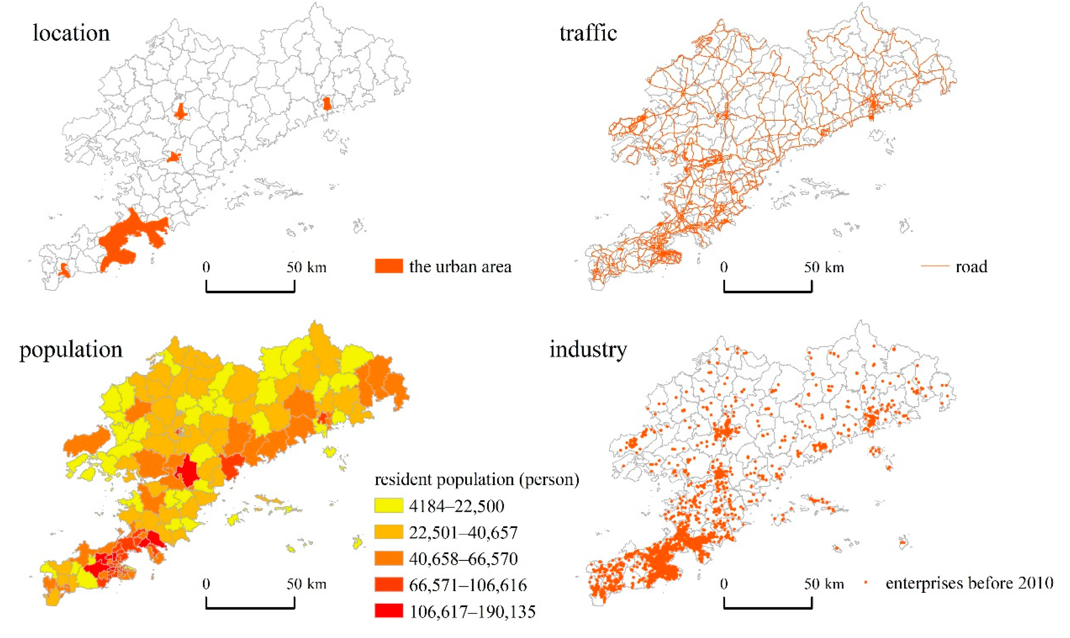
2.1. Study Area

Dalian City is located at the southernmost tip of northeast China, in the temperate continental monsoon climate zone in eastern Asia, close to the Yellow Sea and the Bohai Sea, with a total area of about 12,574 square kilometers. Dalian is one of the five cities under separate social and economic development plans in China, and is an important port, industry, trade, and tourism city in China. In 2020, Dalian’s GDP was about 700 billion yuan, and its permanent population is about 7.45 million. As of 31 December 2020, Dalian has a jurisdiction of over 7 municipal districts, 1 county, and 2 county-level cities. The city has 150 township-level administrative units, including 102 sub-districts, 33 towns, 14 townships, and overseas Chinese fruit tree farms (Figure 1).

2.2. Indicator System and Data Sources

2.2.1. Dependent Variable Index Selection and Quantification

Considering the difficulty of obtaining data at the township levels, we selected the annual number of newly registered enterprises as the dependent variable to characterize the effectiveness of administrative division adjustments. Although an increase in the number of registered enterprise entities cannot cover the entire effect of the adjustments, it can represent their core focus to promote regional economic development and employment while reflecting the basic achieved results. Data deposited in the Qichacha Registered Enterprise Database were screened and downloaded according to three conditions: the registered location was Dalian City, the registered capital exceeded 10 million yuan, and the number of insured was greater than 0. The raw data for newly registered enterprises in each township-level administrative units in Dalian City were obtained for each year from 2010 to 2020. To reflect differences in scale among enterprises, the scale weighting (Formula (1)) and extreme-value normalization processing (Formula (2)) were used to calculate Std _ Y i t and the annual number of new “standard enterprises” in the townships and sub-districts.
Y i t = j [ ln ( y i t j 1000 ) + 1 ]
Std Y i t = Y i t Min ( Y i t ) Max ( Y i t )
In Formula (1), y i t j represents the amount of registered capital of the j enterprise in town (sub-district) i. In Formula (2), Min ( Y i t ) and Max ( Y i t ) ,   ( Y i t ) respectively represent the minimum and maximum number of newly registered important enterprise entities in a town (sub-district) within the year t.

2.2.2. Selection and Quantification of Independent Variable Indicators

Administrative division adjustment was used as the core indicator of the evaluation system. This study initially provided two assumptions, that is, the adjustment of administrative divisions is beneficial to the economic development of townships and towns and promotes the growth of newly registered enterprises. Further, it is assumed that the adjustment of administrative divisions has a time lag, and the effect will be received from the next year [24]. At the same time, it ignores the differences in attributes such as economic strength and administrative power of different subordinate districts, cities and counties. Based on the above assumptions, the adjustment of the administrative divisions of township-level administrative units in Dalian can be divided into 5 types. Affiliation change ( X i t a _ 1 ) refers to the transfer of townships and sub-districts from one county to other counties in a certain year. Removal of one township to another ( X i t a _ 2 ) refers to changing the administrative system from a township with more agricultural activities and weaker economic strength to a township with a large population, a mostly non-agricultural population, and a certain industrial area. Townships to sub-districts ( X i t a _ 3 ) refers to changing the management area of the township government, which has greater authority in economic and social management, to the management area of the sub-district office that only exercises management rights on behalf of the higher-level government. This usually means faster urban development and improved administrative efficiency. Consolidation of sub-districts ( X i t a _ 4 ) refers to the act of splitting or merging sub-districts. Newly established sub-districts ( X i t a _ 5 ) refers to the establishment of a grassroots management organization called the sub-district office to manage a certain area. Figure 2 shows the adjustment process of the administrative divisions of townships and sub-districts in Dalian from 2010 to 2020.
The Boolean function was used to quantify the effects of adjusting various types of administrative divisions. The townships and sub-districts involved in affiliation changes, the removal of one township to another, townships to sub-districts, and the consolidation of sub-districts are assigned a value of 1 from the year following the year of the change. Newly established sub-districts involved in the split are assigned a value of 1, and other cases are assigned a value of 0. The index data for an affiliation change ( X i t a _ 1 ), removing one township to another ( X i t a _ 2 ), adjusting townships to sub-districts ( X i t a _ 3 ), consolidating sub-districts ( X i t a _ 4 ), and establishing new sub-districts ( X i t a _ 5 ) were weighted, summed, and further standardized. The adjustment index ( X i t a ) of each township and sub-district administrative division were determined.
Considering that other factors may affect the agglomeration of enterprises (whether the region is covered by governmental benefits or whether the supply of labor elements in the region is sufficient), all of these conditions will have a certain impact on the processes and results of enterprise agglomeration. As the influence of other potential factors cannot be eliminated, this study incorporates the adjustment in townships administrative divisions as the core independent variable, and adds policy, location, traffic, population, and industry factors as reference factors. We focused on exploring the effects of township adjustments and sub-district administrative divisions on regional enterprise agglomeration and economic development under the combined action of various factors.

2.3. Data Sources

The data acquired in this study included basic geospatial data and socioeconomic statistics for Dalian City. Among the basic geospatial data, the administrative division adjustment data related to this study were mostly incorporated from the website of the National Administrative Division Information Inquiry Platform of the Ministry of Civil Affairs of the People’s Republic of China (http://xzqh.mca.gov.cn/map, accessed on 1 March 2022), the website of the administrative division code of the Ministry of Civil Affairs of the People’s Republic of China (https://www.mca.gov.cn/article/sj/xzqh/, accessed on 1 March 2022), the website of the State Council of the People's Republic of China (http://www.gov.cn/, accessed on 1 March 2022), China Administrative Division website (http://www.xzqh.org/html/, accessed on 1 March 2022), the Dalian City Municipal People’s Government website (https://www.dl.gov.cn/, accessed on 1 March 2022), and the “Brief Book of Administrative Divisions of the People’s Republic of China” over the years. The vectorized data, such as road traffic data, were downloaded from the OSM website (https://www.openstreetmap.org, accessed on 5 March 2022), and the Geospatial Data Cloud website (https://www.gscloud.cn/, accessed on 5 March 2022). Among the social and economic statistical data, policy information, data on the resident population in townships and sub-districts, and data on registered enterprises were recollected and collated from the Dalian City Municipal People’s Government website (https://www.dl.gov.cn/, accessed on 9 March 2022), the Dalian City Statistical Yearbook (2011–2021), the 6th Dalian City Population Census Statistical Communiqué, and the Qichacha website (https://www.qcc.com/, accessed on 7 March 2022). The indicator–evaluation system and data sources used in this study are detailed in Table 1. Figure 3 shows the basic data of location factors, traffic factors, population-based factors, and industry-based factors.

2.4. Research Methods

2.4.1. Ordinary Least Square (OLS) Method

The OLS method can establish a linear relationship between a dependent variable and an independent variable and is therefore a commonly used relationship model. Mathematically, the OLS model is expressed as follows:
Y i = β 0 + i β i X i + ε 0
In the formula, Y i is the explained variable, β 0 is the intercept term, β i is the regression coefficient of the independent variable X i , and ε 0 is the error term.
In this study, the OLS model was used to determine the linear relationships between the variables to be explained and various explanatory variables. Subsequently, the model was utilized to judge the overall impact of factors, such as administrative division adjustments on regional enterprise agglomeration and economic development. However, since the OLS model is a global model, its regression parameters were solely utilized to estimate averages and could not capture the spatiotemporal differences of regression coefficients [57]. Therefore, to explore the temporal and spatial differences of the impact of administrative division adjustments, we utilized the OLS model in combination with the GTWR model.

2.4.2. GTWR Model

The GTWR model is an extension of the OLS model. Compared with the latter, the GTRW model takes into account the spatial heterogeneity of the regression coefficients that change with the geographical differences of the samples [58] and factors in the temporal evolution of the characteristics of the regression coefficients. The mathematical model is as follows:
Y i = β 0 ( u i , v i , t i ) + k β k ( u i ,   v i ,   t i ) X i k + ε i
In the formula, Y i is the explained variable, n is the number of samples, k is the number of independent variables of sample i, ( u i ,   v i ,   t i ) represent the spatiotemporal coordinates of sample point i, β 0 ( u i ,   v i ,   t i ) represent the space-time intercept term for i, X i k represents the kth independent variable value of sample i, and β k ( u i ,   v i ,   t i ) represent the regression coefficient of the kth independent variable of sample i. The regression coefficient β i of sample point i was calculated using the locally weighted least squares method (Equation (5)).
β ^ i = ( X T W i X ) 1 X T W i Y
where W i is an n-order diagonal matrix, and w i j S T in the matrix is the space–time weight function that decays with increasing space–time distances. In this study, we followed the processing method of Huang et al. (2010) [58] to solve the space–time distance and weight matrix using the following formulas:
d i j S T = λ [ ( u i u j ) 2 + ( v i v j ) 2 ] + μ ( t i t j ) 2
w i j S T =   exp { d i j S T ( h S T ) 2 }
where d i j S T is the space–time distance between sample point i and sample point j, and λ and μ are space and time distance factors, respectively, which indicate the balance between space distance and time distance. To reduce the unknown parameters in the model, λ = 1 was usually selected. The space–time bandwidth h S T was utilized to adjust the relationship between the weight and distance. We selected the minimum cross-validation method to determine the solution.

3. Results

3.1. Regression Model

Based on the index evaluation system constructed above, the OLS model was generated with the aid of the least-squares analysis tool provided in the GeoDa software, and the following relationship was obtained:
Std Y i t   = 0.0108 0.0420 X i t a + 0.0134 X i t b 0.0231 X i t c + 0.0483 X i t d + 0.0134 X i t e + 0.9264 X i t f
The model validity parameters are shown in Table 2.
Overall, adjusting the administrative divisions of townships and sub-districts in Dalian City from 2010 to 2020 displayed a weak negative effect on regional enterprise agglomeration and economic development, whereas positive effects were observed to varying degrees in terms of the industrial foundation and traffic. The effect on demographics was not significant.
As shown in Table 2, the regression coefficient of the administrative division adjustment was −0.042, indicating that the township division adjustment carried out in Dalian City in recent years did not effectively promote regional economic development, but in fact impeded it to a certain extent. This raises new questions for optimizing city planning for future administrative division adjustments. Among other factors, the regression coefficient of the basic factor of industrial development was highest at 0.9264, reflecting its decisive role in enterprise agglomeration. Compared with the industry, the regression coefficient of transportation was smaller (only 0.0483), but it still indicates the importance of convenient transportation conditions for enterprise agglomeration and economic development. The regression coefficients of the remaining factors were all small, which shows that policy, population, and location were not core influencing factors of enterprise agglomeration and economic development. It is noteworthy that due to limitations resulting from the difficulty in obtaining data during the study period, this study solely introduces the “robust strength indicator” of the industrial development foundation from the perspective of enterprise agglomeration and promoting regional economic development. From this evaluation, we conclude that the effects of adjusting townships and sub-district-administrative divisions were relatively weak, although these results do not completely negate the overall impact of the adjustment of administrative divisions on regional development.

3.2. Time Series

Based on the OLS model, the regression coefficient of each influencing factor was analyzed, and the annual influence coefficients of the administrative division adjustment ( X i t a ), policy ( X i t b ), location and transportation ( X i t c ), population ( X i t d ), and industry ( X i t e ) in the township on regional enterprise agglomeration and economic development from 2010 to 2020 were calculated. After performing these calculations, we draw a graph showing the change in adjustment factor trends for the township and sub-district administrative divisions on regional enterprise agglomeration and economic development from 2010 to 2020 (Figure 4).
The effect of adjusting the township and sub-district administrative divisions in regional economic development indicated a gradual weakening trend; that is, the positive effect in 2010–2011 gradually turned into a negative effect (Figure 4). Although few fluctuations occurred since then, the overall impact remained negative, and the degree gradually increased over time, raising new questions for the future adjustments of administrative divisions. Our findings indicated that, with time, the effect of township and sub-district administrative divisions on regional enterprise agglomeration and economic development gradually weakened and disappeared. In addition, the disturbance effects brought about by adjusting administrative divisions have become increasingly prominent, exposing the practical problem that administrative division adjustment in the city in recent years was effective in the short term, but insufficient in the long term.

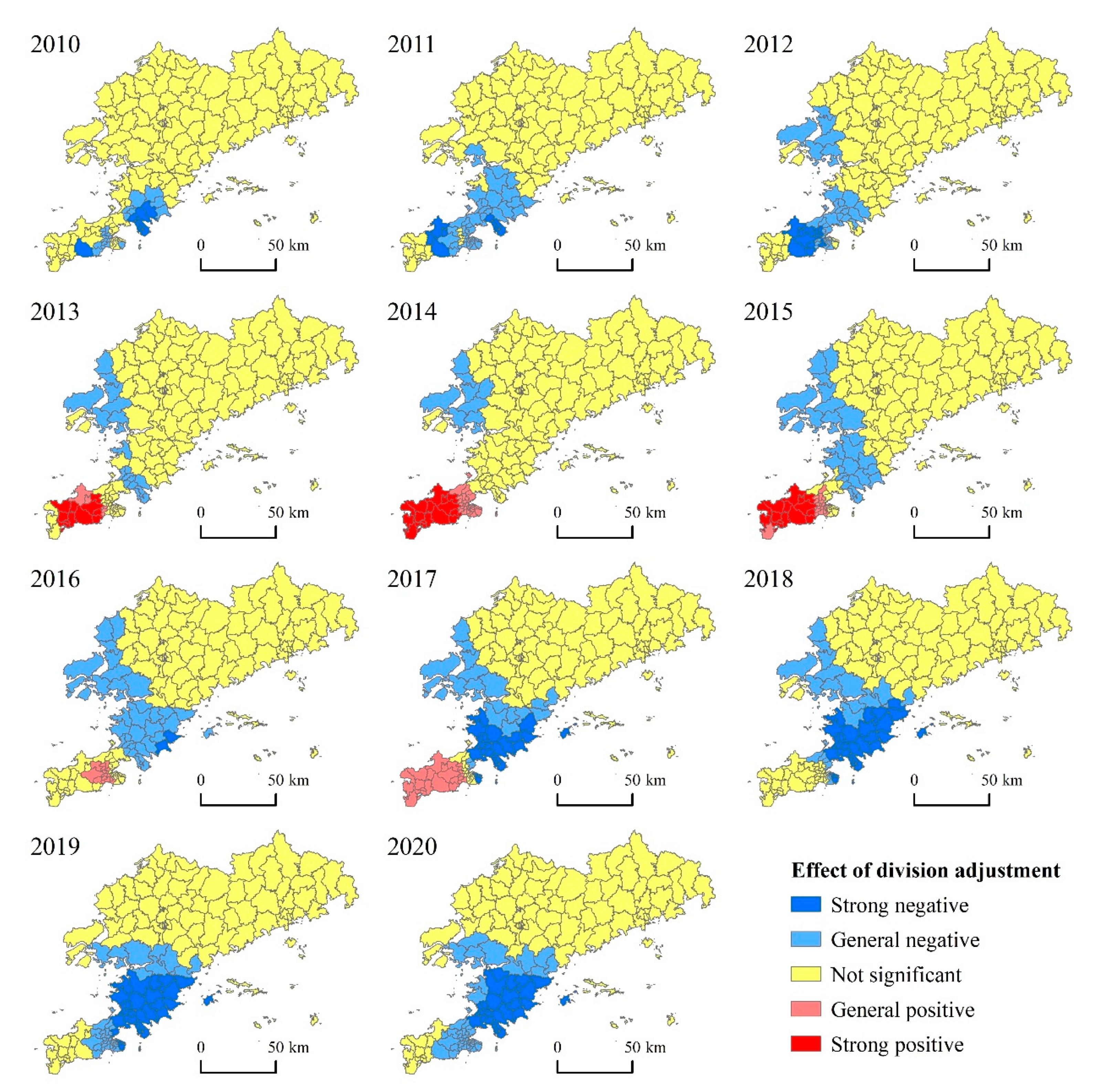
3.3. Spatial Evolution of Administrative Divisions

Our GTWR analysis revealed the influence coefficients of the administrative division adjustments for each township and sub-district from 2010 to 2020, and a corresponding spatial-evolution map was drawn (Figure 5).
The effect of adjusting the administrative divisions of townships in Dalian City during the study period indicated obvious spatial evolution characteristics (Figure 5). A positively impacted area briefly appeared in the southern urban area of Dalian City. However, the negatively impacted areas were steadily concentrated in Jinzhou District and nearby areas located in the central part of Dalian City. The range of the influenced area gradually spread to the south over time.
From the perspective of spatial distribution, the positively influenced areas (including those showing a very strong or relatively strong positive influence) appeared briefly in the southern urban area of Dalian City, namely in the Lvshunkou, Ganjingzi, and Shahekou Districts. These data indicate that administrative division adjustments in the abovementioned regions demonstrated a certain positive effect on regional enterprise agglomeration and economic development. It is not worthy that these regions experienced fewer administrative division adjustments during the study period, which suggests that relatively stable administrative divisions were beneficial for regional economic development to a certain extent. The areas with no obvious impact were stably distributed in the peripheral counties and urban areas in the north of Dalian City, including Zhuanghe City, the northern part of Wafangdian City, the northern part of Pulandian District, and Changhai County, indicating that the administrative division adjustments had a weak effect on economic development in the abovementioned areas. The negatively affected areas (including those showing a very strong or relatively strong negative influence) were concentrated in Jinzhou District, Pulandian District, and Wafangdian City, which are located in the northern part of the main urban area of Dalian City. These areas are not only at the forefront of the urbanization process in Dalian City, but are also located in an area with frequent administrative division adjustments. Regarding the regression results, the administrative division adjustments in these regions did not promote, but rather, implied, a negative effect on regional enterprise agglomeration and economic development, which also confirmed the importance of the stability of administrative divisions. From the perspective of spatial evolution, the positively affected areas experienced a rapid evolution in terms of emergence, spread, shrinkage, and disappearance during the study period, while the negatively affected areas were relatively stable and showed a trend of development spreading to the south.

4. Discussion

In the process of rapid urbanization, the timely adjustment of administrative divisions is necessary, but this adjustment cannot fundamentally solve the problem of regional economic integration [41]. The adjustment of administrative divisions is related to the long-term development of the city and the prosperity and stability of society. The scientific demonstration of the adjustment of administrative divisions should be strengthened. The objectives and principles of adjustment, the extent and scope of adjustment, and the mode and operation mechanism of adjustment need to be carefully considered. The situation should be reviewed, the advantages and disadvantages should be weighed, and multiple parties should be considered. As a means of optimizing urban spatial organization, administrative division adjustments should take into account the economic development of townships, population agglomeration, transportation, history and culture, land use, ecological protection, and other objectives [59,60]. In addition, the adjustment of township administrative divisions has standardized their establishment and adjustment and has strengthened the disclosure and timely release of statistical information.
Administrative division adjustment faces a dilemma; that is, on one hand, if the development performance cannot be achieved as soon as possible, it will be difficult for the public to agree with the rationality of the division adjustment. On the other hand, eagerness to achieve success in the short term can easily lead to development deviation, and it is difficult to ensure the sustainability of regional strategic development [61]. The urban economic growth premised on administrative means does not have long-term effects. Moreover, the short-term effect of township administrative division adjustments may be related to the subjective initiative of the cadres and the masses. Attention should be paid to preventing risks and costs arising from the adjustment of administrative divisions and to the connection of relevant policies and the diversion and transfer of officials.
In the process of urbanization in China, various functional areas, such as industrial parks, development zones, and new urban areas, have brought a series of challenges to the urban governance of administrative divisions, causing new problems of unbalanced and insufficient development [51]. Through several rounds of decentralization, the Dalian City Municipal Government has given a number of municipal-level administrative powers to Jinpu New District, Dalian City High-Tech Industrial Park, and other parks. This caused a disturbance and had a certain degree of impact on the adjustment effect of administrative divisions. This makes it difficult for the Dalian City metropolitan area to achieve complete integration and restricts the modernization of Dalian City’s municipal governance capacity. Dalian City must thoroughly straighten out the relationship between administrative and functional areas to truly realize a unified governance system for the metropolitan area.
In summary, the effect of implementing administrative division adjustments varied with time and location. Therefore, in future administrative division efforts, it will be important to uphold the principle of respecting history and adjusting measures to local conditions. We should also strengthen the scientific argumentation for the adjustment and decision-making processes, further improve the governance capacity, and build a modern national governance system.

5. Conclusions

Using the GTWR model, we constructed an index system suitable for evaluating the effectiveness of administrative division adjustments and explored their impact on the urban, rural, and spatiotemporal evolution characteristics in townships and sub-districts in Dalian City from 2010 to 2020. The technical method was based on GIS (Geographic Information System), is innovative to a certain extent, and has value for optimizing future administrative division adjustments in Dalian City.
(1).
According to the regression results of the OLS model from 2010 to 2020, the administrative division adjustments of townships and sub-districts in Dalian City had a weak negative effect on regional economic development, while positive effects were observed to varying degrees for the industrial foundation and transportation. Policy, location, and population did not significantly impact enterprise agglomeration or economic development.
(2).
During the study period, the effect of adjusting the administrative divisions of the townships and sub-districts in Dalian City on regional economic development turned from positive to negative over time, and the negative effect gradually increased. This finding exposes the real problem: that the adjustment of the administrative divisions of townships and sub-districts conducted in Dalian City in recent years achieved short-term effects, but insufficient long-term effects.
(3).
According to the GTWR results, the 2010–2020 adjustments of township and sub-district administrative divisions positively affected regional enterprise agglomeration and economic development, but only over a relatively short period of time and within a relatively small geographical scope. However, the more extensive negative impact indicates that maintaining the relative stability of administrative divisions is more beneficial for promoting the economic development of Dalian City.
Limited by data availability at the township level, we encountered great difficulties in obtaining sufficient data and sources. Only the number of newly registered enterprises could be utilized to represent the scale of enterprise agglomeration and the level of economic development in townships and sub-districts. If multi-perspective and high-precision experimental data can be obtained in the future, the depth and breadth of research on this topic can be further improved.

Author Contributions

Conceptualization, Z.Z. and L.W. (Lingen Wang); methodology, Z.Z. and L.W. (Lingen Wang); software, Z.Z.; validation, Y.L. and L.W. (Li Wang); formal analysis, L.W. (Li Wang) and W.L.; investigation, L.W. (Li Wang); resources, W.L. and L.W. (Li Wang); data curation, Y.L.; writing—original draft preparation, Y.L.; writing—review and editing, Z.Z.; visualization, Y.L. and W.L.; supervision, Z.Z.; project administration, Z.Z.; funding acquisition, Z.Z. All authors have read and agreed to the published version of the manuscript.

Funding

The research was funded by the Humanities and Social Sciences Research Project of Liaoning Provincial Department of Education, grant number LJKQR2021046; Youth Innovation Promotion Association of Chinese Academy of Sciences.

Institutional Review Board Statement

Not applicable.

Informed Consent Statement

Not applicable.

Data Availability Statement

Not applicable.

Conflicts of Interest

The authors declare no conflict of interest.

References

  1. Wang, K.Y.; Chen, T.; Liu, Y. New discussion and reflection on “Administrative division itself can be seen as a resource”. Geogr. Res. 2019, 38, 195–206. [Google Scholar]
  2. Liu, J.D.; Jin, R.C.; Zhou, K.Y. Chinese Political Geography; Science Press: Beijing, China, 1999. [Google Scholar]
  3. King, P. Hardwiring weak ties: Interorganizational computer-mediated communication, occupational communities, and organizational change. Organ. Sci. 1995, 6, 479–486. [Google Scholar]
  4. Williams, O.P.; Press, C. Democracy in Urban America: Readings on Government and Politics; Rand McNally: Chicago, IL, USA, 1961. [Google Scholar]
  5. Feiock, R.C. Metropolitan governance and institutional collective action. Urban Aff. Rev. 2009, 44, 356–377. [Google Scholar] [CrossRef]
  6. Wheeler, S.M. The new regionalism: Key characteristics of an emerging movement. J. Am. Plan. Assoc. 2002, 68, 266–267. [Google Scholar] [CrossRef]
  7. Flanagan, R.M. Metropolitan government and governance: Theoretical perspectives, empirical analysis, and the future by G. Ross Stephens; Nelson Wikstrom. Political Sci. Q. 2000, 115, 164–166. [Google Scholar] [CrossRef]
  8. Higgins, D. The processes of reorganizing local government in Canada. Can. J. Political Sci. 1986, 19, 219–242. [Google Scholar] [CrossRef]
  9. Boria, J.; Castells, M. Local and global: Management of cities in the information age. Berkeley Plan. J. 2000, 65, 232–233. [Google Scholar]
  10. Wei, Y.H.; Dennis, Y. Decentralization, marketization, and globalization: The triple processes underlying regional development in China. Asian Geogr. 2001, 20, 7–23. [Google Scholar] [CrossRef]
  11. Yang, J.; Guo, A.; Li, Y.; Zhang, Y.; Li, X. Simulation of landscape spatial layout evolution in rural-urban fringe areas: A case study of Ganjingzi District. GIScience Remote Sens. 2019, 56, 388–405. [Google Scholar] [CrossRef]
  12. He, F.; Yang, J.; Zhang, Y.Q.; Sun, D.; Wang, L.; Xiao, X.; Xia, J. Offshore Island Connection Line: A new perspective of coastal urban development boundary simulation and multi-scenario prediction. GIScience Remote Sens. 2022, 59, 801–821. [Google Scholar] [CrossRef]
  13. Yang, J.; Yang, R.X.; Chen, M.H.; Su, C.H.J.; Zhi, Y.; Xi, J. Effects of rural revitalization on rural tourism. J. Hosp. Tour. Manag. 2021, 47, 35–45. [Google Scholar] [CrossRef]
  14. He, B.J.; Zhao, D.X.; Zhu, J.; Darko, A.; Gou, Z.H. Promoting and implementing urban sustainability in China: An integration of sustainable initiatives at different urban scales. Habitat Int. 2018, 82, 83–93. [Google Scholar] [CrossRef]
  15. Yu, H.S.; Yang, J.; Sun, D.Q.; Li, T.; Liu, Y. Spatial responses of ecosystem service value during the development of urban agglomerations. Land 2022, 11, 165. [Google Scholar] [CrossRef]
  16. Luo, X.L.; Yin, J.; Tian, D. Administrative boundary re-organization in Nanjing metropolitan region. Geogr. Res. 2010, 29, 1746–1756. [Google Scholar]
  17. Wang, K.Y.; Chen, T. Geographical prospects of spatial governance through a review on administrative divisions. Acta Geogr. Sin. 2018, 73, 688–700. [Google Scholar]
  18. Zhu, J.H.; Chen, T.; Wang, K.Y.; Wei, Q. Spatial pattern evolution and driving force analysis of administrative division in China since the reform and opening-up. Geogr. Res. 2015, 34, 247–258. [Google Scholar]
  19. Fan, J.C. A preliminary study on the stage and effect of the adjustment of the division of administrative areas of Zhejiang province in China since 1979. Econ. Geogr. 2004, 24, 449–453. [Google Scholar]
  20. Wang, K.Y.; Chen, T. Reflections on the adjustment of administrative divisions in large cities—taking the adjustment of administrative divisions in Guangzhou in recent years as an example. Urban Probl. 2006, 25, 70–75. [Google Scholar]
  21. Wang, D.G.; Sha, M.Y.; Zhu, M. Urbanization effect and action mechanism of township administrative division adjustment: A case study of typical townships adjusted to three types of divisions in Henan province. China Anc. City 2020, 34, 26–33. [Google Scholar]
  22. Yin, J.; Luo, X.L. From turning county into district to district restructuring: A new trend in county-level administrative division adjustment in China. City Plan. Rev. 2013, 37, 9–15. [Google Scholar]
  23. Xiao, Y.C. Research on the Adjustment of the Township Administrative Division under the Urban-Rural Integration Background—Taking Suxian District of Hunan Province as an Example; Xiangtan University: Xiangtan, China, 2014. [Google Scholar]
  24. Li, H.; Xu, X.X. Impact analysis of turning counties (cities) into districts to the urban economic growth in China. Acta Geogr. Sin. 2015, 70, 1202–1214. [Google Scholar]
  25. Zhuang, R.L.; Li, G.Q.; Liang, L.W.; Kena, M. Turning county into district and regional economic growth: Policy evaluation based on difference-in-difference method. Geogr. Res. 2020, 39, 1386–1400. [Google Scholar]
  26. Zhao, B.; Wang, K.Y.; Zhao, Y.C. Characteristics, effects, and influencing factors of the relocation of administrative centers at or above the county level in China. Prog. Geogr. 2022, 41, 185–198. [Google Scholar] [CrossRef]
  27. Wang, X.B.; Nie, H.F. Administrative Division Adjustment and Economic Growth. J. Manag. World 2010, 26, 42–53. [Google Scholar]
  28. Wang, F.L.; Zhang, C.Y. Impacts of administrative division adjustment on housing price in urban China. Geogr. Res. 2017, 36, 913–925. [Google Scholar]
  29. Lu, S.F.; Wu, Y.P.; Xie, X. The benefit of historical reputation: Evidence from the city-renaming reforms in China. China Econ. Q. 2018, 17, 1055–1078. [Google Scholar]
  30. Jin, Z.K.; Xu, W. The administrative regionalization adjustment and the development of service industry—A comparative study of Suzhou and Changzhou based on experimental method. Econ. Geogr. 2015, 35, 63–69. [Google Scholar]
  31. Liu, Y.G.; Jin, J. Effect of city administrative division adjustment on urbanization: A case study of Zhongshan city. Prog. Geogr. 2014, 33, 1047–1057. [Google Scholar]
  32. Zhao, B.; Wang, K.Y.; Wang, F.Y.; Liu, H. The characteristics and changing trend of administrative boundary above county level in China. Geogr. Res. 2021, 40, 2494–2507. [Google Scholar]
  33. Lv, G.J. Research on the Adjustment of Township Administrative Divisions Based on the Development of Agglomeration Economy: Taking Jinyun County, Zhejiang Province as an Example; Zhejiang University of Technology: Hangzhou, China, 2011. [Google Scholar]
  34. Zhao, B.; Zhuang, R.L.; Wang, S.C. The optimization study of the administrative area of Jiangsu province based on the spatial field energy. Econ. Geogr. 2016, 36, 8–17. [Google Scholar]
  35. Yang, Y. Research on the Effect Evaluation of Administrative Division Adjustment Based on GTWR; Liaoning Normal University: Dalian, China, 2021. [Google Scholar]
  36. Chen, Z. On the regional economic effects about adjustment of administrative regions at prefecture level—a case study of Sichuan province. Econ. Geogr. 2006, 26, 418–421. [Google Scholar]
  37. Wang, X.B.; Xie, X.P. Regional market’s administrative integration and economic growth. South China J. Econ. 2012, 3, 23–36. [Google Scholar]
  38. Chen, G.; Li, X. The reexamination of the administrative division adjustment and the economic development of Chongqing: An analysis based on labor productivity. China Econ. Stud. 2017, 59, 40–51. [Google Scholar]
  39. Hopkins, L.D. Urban Development: The Logic of Making Plans; Island Press: Chicago, IL, USA, 2001. [Google Scholar]
  40. Wagenaar, F.P. Excises, postal services, oaths of office and property taxes: How small administrative adjustments led to large changes in intergovernmental relations. Adm. Theory Prax. 2004, 26, 545–565. [Google Scholar] [CrossRef]
  41. Wei, H.; Wei, Q.Q.; Cao, T.Y.; Zhao, J. Types, problems and changes for readjustment of administrative divisions in the process of urbanization. Hum. Geogr. 2009, 24, 55–58. [Google Scholar]
  42. Zhang, J.X.; Fan, C.L.; Shen, J.F. On administrative division adjustment and urbanization promotion. Urban Plan. Forum 2002, 46, 25–28. [Google Scholar]
  43. Xie, D.X. Fast urbanized time administrative regionalization adjustment research. Mod. Urban Res. 2009, 24, 82–87. [Google Scholar]
  44. Liu, J.D. Perspective of the “administrative region economy” phenomenon in China’s transitional period—an introduction of human-economic geography with Chinese characteristics. Econ. Geogr. 2006, 26, 897–901. [Google Scholar]
  45. Tang, W.; Wang, Y. Administrative boundary adjustment and urbanization of population: Evidence from city-county merger in China. Econ. Res. J. 2015, 50, 72–85. [Google Scholar]
  46. Zhao, J.J. How administrative division promotes regional collaborative development? A case study of the Beijing-Tianjin-Hebei region. Comp. Econ. Soc. Syst. 2016, 32, 1–10. [Google Scholar]
  47. Chen, Y.F.; Wang, K.Y. Influence and mechanism of “turning counties (cities) into districts” on urban public service allocation and spatial layout. Econ. Geogr. 2019, 39, 76–86. [Google Scholar]
  48. Li, K.Y. Research on the urban spatial expansion under administrative district adjustment—A case study of Panyu district, Guangzhou. Econ. Geogr. 2010, 30, 22–26. [Google Scholar]
  49. Shang, Z.Y.; Lu, X.X.; Zhang, X.L.; Wu, Q. The impacts of administrative district adjustment on the evolution of urban spatial structure: A case of Huai’an in Jiangsu province. Econ. Geogr. 2015, 35, 61–67. [Google Scholar]
  50. Su, J.Z.; Wei, Q.Q.; Guo, H.L. The mechanism and adjustment of urban sprawl of Guangzhou. Acta Geogr. Sin. 2005, 60, 626–636. [Google Scholar]
  51. Zhuang, L.; Ye, C.; Ma, W.; Zhao, B.; Hu, S. Production of space and developmental logic of new urban districts in China. Acta Geogr. Sin. 2019, 74, 1548–1562. [Google Scholar]
  52. Ding, X.J. Research on Driving Factors of Dalian Metropolitan Industrial Agglomeration Development; Liaoning Normal University: Dalian, China, 2022. [Google Scholar]
  53. Du, P.; Yan, P.P. Evolution of spatial pattern and influencing factors of manufacturing industry in Dalian city. Resour. Dev. Mark. 2020, 36, 52–56. [Google Scholar]
  54. Zhang, H.; Du, P.; Liu, W.B. Analysis on the spatial evolution pattern and influencing factors of manufacturing enterprises in Shenyang city. Resour. Dev. Mark. 2020, 36, 1100–1108. [Google Scholar]
  55. Yu, T.T.; Song, Y.X.; Hao, F.L.; Rong, A. Space Pattern Evolution of Population Distribution and the Driving Factors in Northeast China. Sci. Geogr. Sin. 2017, 37, 709–717. [Google Scholar]
  56. Liu, H.C.; Fan, J.; Zhou, D.J.; Zhang, H. The evolution of spatial distribution and its influencing factors of high-energy intensive industry in China since 2000. Econ. Geogr. 2019, 39, 110–118. [Google Scholar]
  57. Arnio, A.N.; Baumer, E.P. Demography, foreclosure, and crime: Assessing spatial heterogeneity in contemporary models of neighborhood crime rates. Demogr. Res. 2012, 26, 449–486. [Google Scholar] [CrossRef] [Green Version]
  58. Huang, B.; Wu, B.; Barry, M. Geographically and temporally weighted regression for modeling spatio-temporal variation in house prices. Int. J. Geogr. Inf. Sci. 2010, 24, 383–401. [Google Scholar] [CrossRef]
  59. Yang, Y.; Dong, W.; Liu, Y. Administrative adjustment of Xinjiang in multiple perspectives. Acta Geogr. Sin. 2013, 68, 1367–1379. [Google Scholar]
  60. Gu, C.L.; Wang, Y.; Shao, Y.; Gu, J. Research on administrative divisions based on functional areas analysis: A case of Shaoxing metropolitan area. Acta Geogr. Sin. 2015, 70, 1187–1201. [Google Scholar]
  61. Lin, T.; Shen, L. At the entrance to a new pattern: The national strategy and administrative division reform. Comp. Econ. Soc. Syst. 2015, 31, 20–31. [Google Scholar]
Figure 1. Overview of the study area.
Land 11 01126 g001
Figure 2. Adjustment of administrative divisions of townships in Dalian from 2010 to 2020.
Land 11 01126 g002
Figure 3. Reference factors rely on basic data.
Land 11 01126 g003
Figure 4. Changing trend in the annual influence coefficients of the administrative division adjustment.
Land 11 01126 g004
Figure 5. Administrative divisions affected regional differences.
Land 11 01126 g005
Table 1. Index system and data source.
VariableIndexData Sources
dependent variableThe number of newly registered important enterprise entities in the year ( Std _ Y i t )Qichacha website
independent variableaffiliation change   ( X i t a _ 1 )Sort out and quantify according to the adjustment process of administrative divisions
removal of one township to another   ( X i t a _ 2 )
townships to sub-districts   ( X i t a _ 3 )
consolidation of sub-districts   ( X i t a _ 4 )
newly established sub-districts   ( X i t a _ 5 )
policy   ( X i t b )Sort out and quantify according to government documents ①
location   ( X i t c )Calculate the distance between the township (sub-district) and the urban area through ArcGIS ②
traffic   ( X i t d )Calculate the density of road networks in town by ArcGIS ③
population   ( X i t e )6th population census ④
industry   ( X i t f )Qichacha website ⑤
Note: ① The government establishes various development zones and functional parks and other urban new areas, and promotes urban space development and corporate space agglomeration through regional development policies such as finance, taxation, and land [51]. Combined with the actual situation of Dalian, three policy factors in the national economic and technological development zone, national high-tech industrial park, and national new area are considered. The township managed by the new urban district is assigned a value of 1, and other cases are set to 0; if the township is simultaneously affected by multiple urban new districts, it is assigned a total value. ② Basically, the central urban area has a radiating and driving effect on industrial development, and the industrial spatial layout will be affected by the distance from the city center [52]. In this paper, the role of the main urban area of Dalian is assigned a value of 1, and the built-up areas of Lushunkou, Pulandian, Wafangdian, and Zhuanghe are assigned a value of 0.5. Moreover, according to the principle of the “exponential decay of distance”, the influence of location factors is assigned to townships in different locations. ③ For a region, the more convenient the traffic conditions, the more competitively advantageous it is, meaning that it has a competitive advantage in reducing logistics costs. In addition, it is also conducive to closing economic and technological ties between enterprises and increases the chance of successful enterprise site selection [53]. This study adopts road network density as a proxy indicator of traffic factors, and ignores the differences in road network density changes during the study period. In view of the special situation of inconvenient transportation on the island, the traffic factor in the island town incorporates the lowest value of the road network density in all townships. ④ A large population means not only a rich labor supply, but also a huge market size [54]. The number of permanent residents in the data of the sixth census in 2010 was utilized as a proxy indicator of population factors, and differences in population changes during the study period were ignored. Referring to the method proposed by Yu et al. (2017) [55], for units whose administrative divisions were inconsistent with those in 2010, the population of each study unit was re-analyzed according to the scope of administrative divisions in 2020. The specific method is as follows: First, convert the vector data into raster data with a density of 1 km × 1 km. Then, according to the 2011–2020 administrative region boundaries, the raster data are summed to give the corrected value of the population data of each research unit in that year. Finally, link it with the administrative division file to obtain the resident population data for each study unit and each year. ⑤ Industrial development is dependent on its own development path, and the historical pattern of the industry affects the current spatial distribution of enterprises [56]. Under normal circumstances, before making a location decision, an enterprise will examine the industrial development foundation of the target area. Select the stock of key enterprises in each township as a proxy index of industrial basic factors. Enterprises should be established before 2010, operating or existing, with a registered capital of not less than 10 million RMB, and the number of insured persons cannot be zero. For the 6591 key enterprises screened, the number of standard enterprises in each township and sub-district is calculated by referring to Formulas (1) and (2).
Table 2. OLS regression model validity parameters.
VariableCoefficientStd. Errort-StatisticProbability
Constant0.01080.00382.83760.0046
X i t a −0.04200.0110−3.81560.0001
X i t b (Policy)0.01340.00612.19010.0287
X i t c (Location)−0.02310.0061−3.78020.0002
X i t d (Traffic)0.04830.01014.78100.0000
X i t e (Population)0.01340.01301.03530.3007
X i t f (Industry)0.92640.018350.53370.0000
Note: R-squared: 0.7472; Adjusted R-squared: 0.7463; F-statistic: 809.4350; Prob(F-statistic): 0.0000.
Publisher’s Note: MDPI stays neutral with regard to jurisdictional claims in published maps and institutional affiliations.

