

Eco-Cultural Development of a Restored Lake Environment: The Case Study of Lake Karla (Thessaly, Greece)

1
Department of Environment, Ionian University, M. Minotou-Giannopoulou Str. Panagoula, GR29100 Zakynthos, Greece
2
Department of Environment, University of Thessaly, Gaiopolis Campus, Ring Road of Larissa-Trikala, GR41500 Larissa, Greece
*
Author to whom correspondence should be addressed.
Land 2023, 12(6), 1227; https://0-doi-org.brum.beds.ac.uk/10.3390/land12061227
Submission received: 13 May 2023
/
Revised: 11 June 2023
/
Accepted: 12 June 2023
/
Published: 13 June 2023
(This article belongs to the Special Issue Land Use Futures for a Sustainable Anthropocene)
Abstract
:Lake Karla is the first reconstructed lake in the EU, supporting agriculture, biodiversity and cultural activities and being part of the Natura 2000 protected area network. In order to investigate opportunities for the sustainable development of the wider lake area, this study aims to identify and assess current ecosystem services in the catchment basin of lake Karla with focus on cultural ecosystem services and in particular on eco-cultural tourism routes and trails. Based on recent literature and field surveys the main results of the study include mapping of ecosystem types and a first overview of potential ecosystem services. Additionally, mapping, assessment and proposal of selected eco-cultural routes alongside with estimation on their carrying capacity is also presented. Finally, discussion on future steps and policy recommendations is provided, towards the integrated, sustainable management of the protected area.
1. Introduction
Lake wetlands are very important but also highly vulnerable ecosystems, since despite covering a small area worldwide, they harbour high levels of biodiversity and contribute disproportionately to ecosystem services [1]. They provide a great variety of direct and indirect ecosystem services, such as provisioning services (e.g., freshwater provision, fisheries), regulating services (e.g., water purification, flood regulation, climatic regulation), maintenance services (e.g., habitat for wildlife), and cultural services (e.g., recreation, research opportunities, birdwatching) (see e.g., [2]). However, during the Anthropocene many lakes around the world have been facing serious challenges, such as water contamination, ecosystem degradation and destruction, due to irrational water utilization and a lack of effective management [3]. Moreover, in the past centuries, instead of attaching importance on wetlands, humans regarded wetlands as a harbor of mosquitoes, carriers of disease, and sources of death resulting to reclaim wetlands in large areas and make full potential use (via land use change) of the wetlands [4]. Almost half of natural wetland habitats were lost between 1970 and 2013 as a result of the human activities, such as dam building or drainage, as indicated in the State of the Environment and Development in the Mediterranean (SoED) [5].
It has been estimated that most of all Mediterranean wetlands have been lost [6]. Alterations of wetland functions resulted in: (a) groundwater level decrease, (b) sea-water intrusion into groundwater aquifers, (c) shortage of irrigation water, (d) frequent flooding of lowlands, (e) salinity and alkalinity problems in soils, (f) gross pollution of ditches and water resources from industrial effluents and agrochemicals, (g) discharge of polluted water into sea, (h) loss of wetland habitats, and (i) decreased biodiversity [7]. For these reasons, nowadays, scientists and managers are struggling to manage the highly degraded lake systems to cope with escalating anthropogenic pressures, examining also the interaction of lakes and social systems for efficient restoration of lakes [4]. It is indicative that the about one-third of the wetland sites have been artificially reconstructed [8].
In Greece, from the early years of the 20th century, many wetlands, i.e., marshland, lagoons and (mainly coastal) lakes, have been partially and fully drained intending to eliminate malaria, to increase agricultural land and for flood protection [9]. Lake Karla, located in eastern Thessaly (Greece), constitutes a unique example at European scale of a natural shallow lake ecosystem that was dried in 1960s and is currently restored [10]. The new artificial reservoir is located in the same place of the old natural lake and is part of the Natura 2000 network included in the Site of Community Importance (SCI) (Natura 2000 code: GR1420004) and in, the Special Protected Area (SPA) (Natura 2000 code: GR1430007) site for birds, being a vital aquatic system of Greece [11]. Lake Karla is hydrologically linked with the Pinios River, directly feeding it, as well as with its drainage basin and the corresponding effluents from the neighboring heavily cultivated agricultural areas, and therefore, receiving fertilizers and agricultural effluents [12]. A thorough analysis of Lake Karla is included in many research and scientific works (e.g., Papadimitriou et al. [11], Panagopoulos and Dimitriou [13], Oikonomou et al. [14]), while a historical overview of the events for the drainage of Lake Karla is included in Giallis and Laspidou [15].
Moreover, and based on resident’s responses in a questionnaire survey, lake Karla protected area is considered as having a high potential for socioeconomic benefits, based on sustainable development of alternative forms of tourism and recreation opportunities, that will provide a new type of income to local and economy [16]. The importance of recreation/ecotourism potential for local societies, has been confirmed and highlighted also with another, more recent (2017) study conducted by Karanikola et al. [17]. Additionally, the work by Vasiliadis et al. [18] highlight the need for alternative (non mass) tourism development in the Region of Thessaly, that is based on all other attributes of the local environment, than the sun, sea and sand tourism approach, aiming to diversification.
Within this framework, the present study, conducted under the first authors PhD research work and study, aims to: (a) assess current ecosystem services in the catchment basin of lake Karla with focus on cultural ecosystem services and in particular on eco-cultural tourism routes and trails, (b) provide pilot trails routes of particular interest and assess their carrying capacity for visitors and (c) support the local and regional goals for integrated development with evident-based outcomes.
2. Materials and Methods
2.1. Study Area
The study area is delineated by the catchment basin of lake Karla, Thessaly, Greece. It consists of the largest part of the Thessaly plain, the major agricultural area in Greece, as well as of natural areas mainly on the eastern part of lake Karla. Within the catchment basin five Natura 2000 network sites are present: one Site of Community Importance (SCI), i.e., “KARLA–MAVROVOUNI–KEFALOVRYSO VELESTINOU–NEOCHORI” (GR1420004), and four Special Protection Areas (SPA), i.e., “OROS MAVROVOUNI” (GR1420006), “PERIOCHI THESSALIKOU KAMPOU” (GR1420011), “PERIOCHI TAMIEFTIRON PROIN LIMNIS KARLAS” (GR1430007) and “OROS PILIO” (GR1430008). In Figure 1 the study area is presented providing information on major cities (i.e., Larissa and Volos) as well as Natura 2000 network sites limits.
2.2. Ecosystem Type Mapping
Ecosystem type mapping was based on available land use–land cover maps [19] combined with habitat type mapping data available for the Natura 2000 site GR1420004 [20]. The mapping typology follows Kokkoris et al. [21] and Kokkoris et al. [22] and provides MAES level 3 ecosystem type mapping for the lake Karla catchment basin. Photointerpretation was also used to improve mapping detail, using orthophotos and satellite imagery, as provided online by the National Cadaster [23], and Google Earth [24]. All GIS-related procedures for the thematic mapping, and representation were conducted using the QGIS platform [25].
2.3. Ecosystem Services Mapping
Identification and mapping of potential ecosystem services provided by the study areas’ ecosystem types, follow [21,26], that provide habitat/ecosystem type correspondence with the main ecosystem services categories. Ecosystem services are classified using the proposed typology of the Common International Classification of Ecosystem Services (CICES) [27] at the section level (i.e., Provisioning, Regulating and maintenance, and Cultural).
2.4. Eco-Cultural Trails Identification, Assessment and Mapping
In order to propose and map pilot trail routes with ecological and cultural value (including historical places, traditional agricultural activities, environmental education) we conducted field surveys by walking throughout the different trails present in the area to identify their value, and register them in a predefined printed table under the following criteria: (a) cultural importance, (b) ecological value, (c) opportunities for education and (d) accessibility for different uses, i.e., hiking, cycling and horse riding. Each criterion was rated for its importance using a Likert scale, i.e., 0: Not important, 1: Very low, 2: Low, 3: Medium, 4: High, 5: Very high. Rating was made by the authors expert judgment, considering the findings for eco-tourism in the area presented by Kogouli [28] and traditional trail descriptions by Trakala et al. [29].
2.5. Visitors Carrying Capacity Assessment
To assess the visitors carrying capacity of the proposed eco-cultural trails and in particular for the activities of hiking, biking and horse riding, we followed the concept provided by Cifuentes [30] and as adapted by Ceballos-Lascuráin [31], using standards provided by Serraos [32] as presented in the work of Palloglou [33] and in the carrying capacity study of LIFE AMYBEAR Project [34] (Table 1). The Carrying capacity was calculated using the formula:
A × U/a × Rf
A = available area for public use (trail distance)
U/a = Area or length required per user
Rf = Rotation factor (number of visits/day). Outdoor recreation is allowed only during daylight; the mean annual daylight in the area (city of Larissa) is ca. seven hours per day [35]. However, since most of the area is protected under the Natura 2000 network, we selected for any activity Rf = 1 (considering also that some activities may take place simultaneously). To identify transport capacity (in order to avoid bottlenecks), we set the time (min) per kilometer needed for each activity, as follows:
- (a)
- For hiking: 20 min/km
- (b)
- For cycling: 3 min/km
- (c)
- For horse riding (trot): 7.5 min/km
3. Results
3.1. Ecosystem Type Mapping
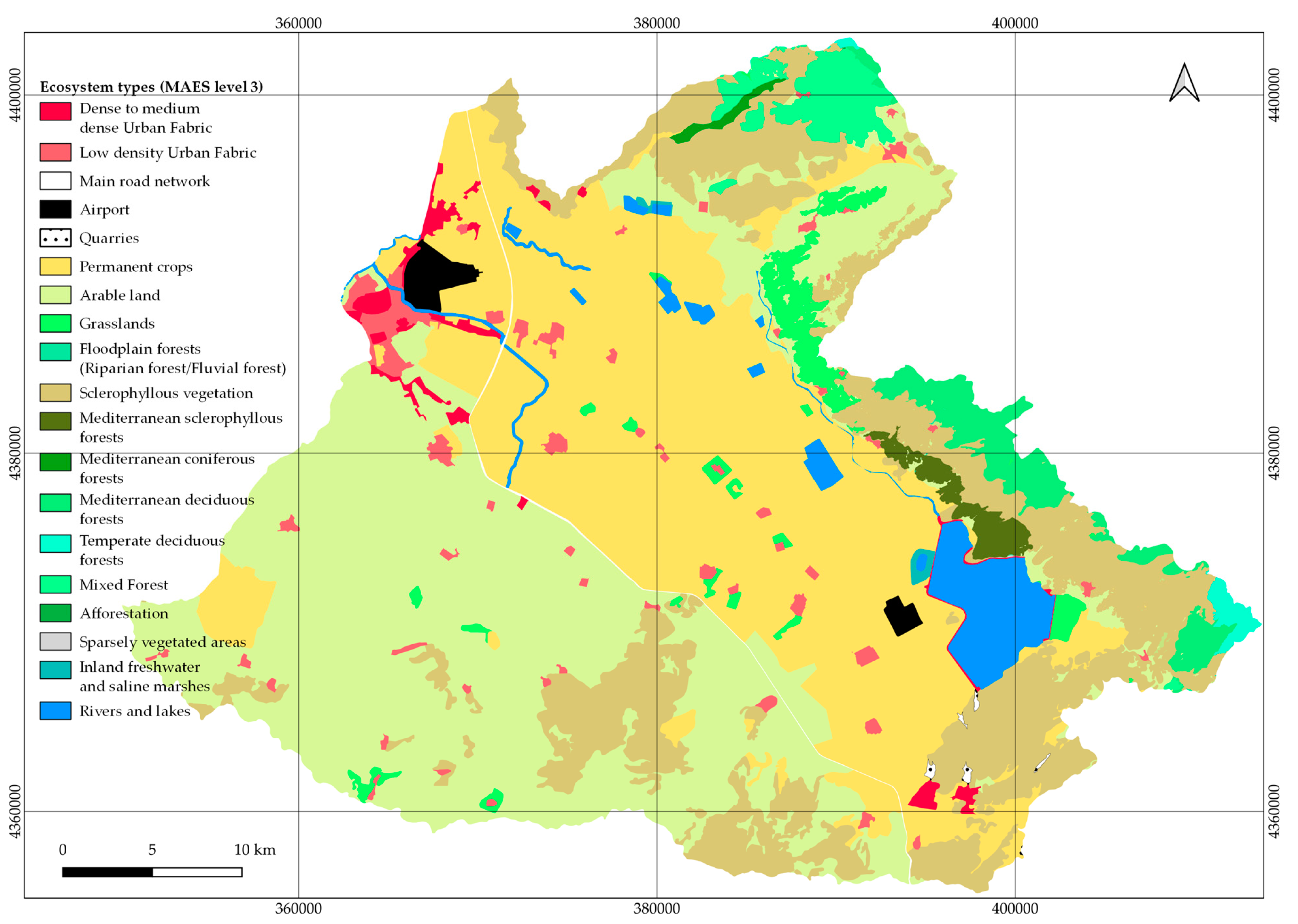
Areas for cultivation and agricultural activity cover more than the half of the study area. More precisely, areas with permanent crops are occupying 32.77% and arable land covers 33.89%; sclerophyllous vegetation is the part of natural vegetation with the largest area cover, contributing with 18.10% of the total area; all other ecosystem types contribute with cover below 3% (Table 2). In Figure 2, the ecosystem type map (MAES level 3) of the study area is presented.
3.2. Ecosystem Services Mapping
The preliminary analysis of the potential supply of ecosystem services in the study area revealed the importance of provisioning services, corresponding to agricultural ecosystem types that prevail in the area, including lake Karla as a water reservoir. Regarding regulating and maintenance ecosystem services, Lake Karla and natural ecosystems, mainly located in the eastern part, range from medium to very high values. Highest values for cultural services are identified mainly in the north- and south- eastern part of the area. A thematic representation of the area’s ecosystem services potential is presented in Figure 3.
3.3. Eco-Cultural Trails Mapping
Field surveys and trail crossings provided a set of ten proposed routes of eco-cultural importance (see Table 3 and Figure 4). For each particular route results on their (a) cultural importance, (b) ecological value, (c) opportunities for education, and (d) accessibility for different uses, i.e., hiking, cycling and horse riding, have been provided and as presented in Table 2. Regarding the total value of each route (total rating), route 8, i.e., Armenio-Achillio-Kalamaki-Elafos-Sklithro-Dasos Polidendriou (former Royal estate), received the highest score (20), followed by routes 6 and 2 (i.e, Kanalia-Trail around lake Karla and Kalamaki-Elafos-Panagia Kampana, respectively). In Table 3 the detailed scoring and total value for each route is presented and Figure 4 provides a thematic map of the proposed eco-cultural routes. It is evident that most routes are located in the eastern, southeastern part of the area, having lake Karla and surrounding wetlands as a reference locality. However, a significant part of the routes crosses natural, semi-natural and agricultural areas, documenting the proposed routes’ ecological and cultural character and importance, that is also represented and highlighted by the rating scores of the respective categories (i.e., cultural importance and ecological value, in Table 3).
3.4. Visitors Carrying Capacity Assessment
The results of the carrying capacity assessment reveal the potential of the proposed eco-cultural routes to support different outdoor recreation uses, i.e., hiking, cycling and horse riding. The shortest route, i.e., Kanalia-Kerasia can support up to 275 hikers, 687 cyclists and 172 horse riders, on daily basis. Additionally, the longest route (i.e., Kanalia-Trail around lake Karla) can support up to 1216 hikers, 3040 cyclists, and 760 horse riders, on a daily basis. All other routes can support intermediate number of users/visitors. In Table 4, the carrying capacity for each route and for each type of activity is presented. The detailed calculations are provided in Table S1 of the Supplementary Material.
However, and in order to avoid “bottlenecks”, e.g., presence of more visitors in the route than the number suggested by the carrying capacity, we should also take into account the time needed for each activity (i.e., hiking, cycling and horse riding). An example of the most common activity, which is hiking, is presented as follows: the time needed to hike 1 km is set to 20 min and the maximum number of visitors is 40 hikers per kilometer. This implies that if more than 40 visitors are allowed to enter the route, within a 20 min period, the carrying capacity will be exceeded, despite the fact that this number is lower than the routes transport capacity. A conservative suggestion is to allow 20 hikers, per 20 min to enter each route, and by this keep the number of individuals per kilometer, significantly lower that the carrying capacity, supporting not only the use of ecological and cultural resources, as well as the satisfaction of visitors (i.e., hiking in a non-crowded route).
4. Discussion
The restored area of Lake Karla (the first-reconstructed lake in Europe) and its surroundings is rendered as a hot spot for biodiversity, historical and cultural importance, providing a best-practice example for wetland restoration and considered as of high importance by the European Union [10,11]. However, despite the fact that the lake and surrounding areas are considered well studied in terms of water resources, water quality and biodiversity (e.g., [10,11,12,36,37,38]) and are under a high-quality environmental protection regime i.e., part of the Natura 2000 network and under the jurisdiction of the Management Unit of Protected Areas of Thessaly [39], its cultural attributes are under-explored in the scientific literature. The results of this study provide a first attempt to spatially identify and assess the ecosystem types present in the area, alongside management and development preferences towards drafting and highlighting priorities for the development of eco- and cultural-tourism at local scale.
4.1. Ecosystems and Ecosystem Services
Based on the ecosystem type mapping at MAES level 3, the prevailing ecosystems are agriculture oriented, traditionally supporting local and regional economy. Following national typologies, it is highlighted that the area is of high importance regarding regulating and maintenance, as well as cultural ecosystem services. The results of this study contribute as a baseline information to the national efforts for the MAES implementation in Greece [21,40], at the local scale; however, field surveys are recommended to streamline spatial extent and validation of ecosystem types and ecosystem services at fine scale, e.g., by using the MAES_GR field survey platform [41] during Management Unit’s visits in the area. Additionally, already available for this purpose participatory mapping and assessment platforms and tools such as the ppGIS-WebGIS [42], developed for the national (Greek) LIFE IP 4 Natura project, should be promoted and used by the wider audience to enrich the relevant geospatial database for the protected area.
4.2. Raising Awareness
One of the most important issues that local stakeholders, decision, and policy makers should consider in order to support eco-cultural tourism is to promote environmental and in particular protected area awareness among locals, using participatory approaches. It is crucial to have informed and aware citizens involved in the decision making processes, in order to adequately select and/or prioritise needs and measures to be applied regarding the sustainable development of the area and in particular on the advantages of eco-cultural tourism. A recent study on the awareness of the Natura 2000 network [43] highlights that is important for policy makers to understand that biodiversity conservation benefits are well beyond a particular area, especially when they are compared to the costs incurred by a smaller group of local stakeholders. Therefore, it is crucial to identify who represents the general public. Given that public participation constitutes a voluntary activity, there is a chance that participants belong or not to the category of citizens who have been identified as being aware.
4.3. Carrynig Capacity Asessment and Limitations of the Study
The carrying capacity assessment revealed the fact that there is an inert strategic advantage for the development of environment-friendly, year-round tourism in the area. However, the calculations on carrying capacity are referring and are limited to the physical carrying capacity, providing a general idea of the maximum number of visitors that can physically fit in each of the proposed routes/trails for the different uses (i.e., hiking, cycling and horse riding), taking into account conservative standards, due to the protection status of the area. Future, applied assessments should include the calculation of the real carrying capacity that integrates correction factors (e.g., for rainfall, solar radiation) and of the effective carrying capacity, that includes limitations based on available infrastructure, management plan, staff etc. [30,31]. Moreover, an updated, detailed assessment on social, economic and regional planning strategies is needed, to identify current baseline conditions (e.g., following previous work conducted by Mastrogianni et al. [16], twenty years ago). By this, the proposed eco-cultural development will be set under a pragmatic framework, that may suggest modifications and improvements, e.g., selection of fewer routes and/or combination of routes, inclusion of more activities or restrictions (e.g., for horse riding near habitats important for conservation in the EU or near habitats of priority importance [44]). Additionally, and in order to capture the actual conditions on which an eco-cultural, sustainable tourism product will be developed, a visitors preferences assessment, based on a face to face or online questionnaire survey is crucial. This proposed study will aim to identify: (a) demand for specific activities, (b) demand for specific services (including accommodation, guided tours, connected trips or other activities), (c) reporting of complains, suggestions and highlights of the area, (d) willingness to pay for different types of activities. In parallel, a similar survey on local residents and stakeholders will point out the expectation of the eco-cultural development of the area and the most important, participate in the process of drafting detailed and tailor-made services that will satisfy visitors, as well as generate sustainable income to local communities.
4.4. Management Implications
The results of the present study provide the baseline information to tackle and generate public discussion for sustainable, integrated tourism development in the area, as requested by national, regional and local objectives for a coupled tourism and nature-culture amelioration [45], where, among other suggestions, old trails and routes upgrade are suggested and eco-tourism activities for the Lake Karla are highlighted.
The proposed eco-cultural routes are selected and designed to support a year-round competitive advantage in the lake area. This is delineated by the suggestion of activities that involve human-nature and human-culture interactions, throughout the routes that remain constant (e.g., historical sites and monuments) or differentiate within the year (in different seasons, e.g., landscape colors, flowering plants, invertebrates, birds). For instance, during autumn, visitors can closely observe agricultural works that prepare the fields for the sowing of winter grains (e.g., wheat, barley and legumes); in autumn and winter visitors can observe the migratory avifauna of the area; in spring and summer visitor can observe uniform areas for cotton, corn and tomato production. Until now, none of these aspects of activities has been integrated into an organised management plant as a tourism product or as field laboratory for research activities, throughout the year.
Additionally, it is suggested to follow the management recommendations provided from the case-study assessment for Lake Stymfalia [46], where different climate and management scenarios have been investigated and cultural (recreational) services have been valued in monetary terms. By this, the management of the area will comply with national and EU standards, provided by national initiatives (e.g., the LIFE IP 4 NATURA project [47]), the EU Biodiversity Strategy [48] and the EU Green Deal [49]. The recently constituted Natural Environment & Climate Change Agency (NECCA) can add value on the already important work of the former Management Body [50] and play the needed, crucial role for an integrated support of Lake Karla protected area’s needs in coordination and synergies with other regional, national and international Natura 2000 sites (e.g., via regional, national or international funding mechanisms, knowledge transfer, co-piloting projects) to maximise effectiveness in management and resources distribution. This study also provides input to the current NECCA national scale initiative to create a network of trails & footpaths in Natura 2000 network sites [51]. However, the key parameter to develop a successful initiative is to allocate who does what, when and where. The under development Special Environmental Studies for the area, will provide measures and actions, as well as zonation for permitted activities and identify the public bodies that will be responsible for future actions. For, now the local Management Unit in cooperation with the municipalities and the region of Thessaly, should take the initiative to leverage resources for setting the baseline conditions for this type of development. Ongoing relevant funding mechanisms (e.g., from NECCA / Recovery and Resilience Facility [52]) provide direct support for actions related to paths and routes in protected areas that should be utilized by the beneficiaries.
5. Conclusions
The catchment area of Lake Karla is a mosaic of different ecosystem types, land uses and socioeconomic demands. Despite its prominent agricultural character provides also significant opportunities for recreational activities to promote year-round tourism in order to support the areas sustainable development. Eco-cultural routes and trails can provide the competitive advantage for the restored Lake Karla and its surrounding areas, exploiting added value from agricultural, cultural and natural landscapes. The results on carrying capacity should be treated with caution, since they only provide a starting point for visitors management and an indicative, baseline information for the potential of the area for selected activities. A detailed, fine-scale assessment of the potential and demand of ecosystem services will also provide valuable guidance for future planning and should be combined with a joint-assessment of current and needed infrastructure, visitors’ control measures and socio-economic demands. Designing routes and other strategic infrastructure for outdoor recreation should include raising awareness among citizens and decision makers in order to properly procced into participatory decision making for spatial planning and tourism development in the area, under the sustainable development framework and the EU Green Deal.
Supplementary Materials
The following supporting information can be downloaded at: https://0-www-mdpi-com.brum.beds.ac.uk/article/10.3390/land12061227/s1, Table S1: Carrying capacity calculation for each route/trail.
Author Contributions
Conceptualization, G.T. and A.M.; methodology, G.T.; validation, G.T. and A.T.; formal analysis, G.T.; investigation, G.T.; resources, G.T. and A.T.; data curation, G.T.; writing—original draft preparation, G.T.; writing—review and editing, G.T., A.M. and A.T.; visualization, G.T.; supervision, A.M. All authors have read and agreed to the published version of the manuscript.
Funding
This research received no external funding.
Data Availability Statement
Not applicable.
Conflicts of Interest
The authors declare no conflict of interest.
References
- Heino, J.; Alahuhta, J.; Bini, L.M.; Cai, Y.; Heiskanen, A.-S.; Hellsten, S.; Kortelainen, P.; Kotamäki, N.; Tolonen, K.T.; Vihervaara, P.; et al. Lakes in the era of global change: Moving beyond single-lake thinking in maintaining biodiversity and ecosystem services. Biol. Rev. 2020, 96, 89–106. [Google Scholar] [CrossRef] [PubMed]
- Xu, X.; Jiang, B.; Tan, Y.; Costanza, R.; Yang, G. Lake-wetland ecosystem services modeling and valuation: Progress, gaps and future directions. Ecosyst. Serv. 2018, 33, 19–28. [Google Scholar] [CrossRef]
- Zhong, S.; Geng, Y.; Qian, Y.; Chen, W.; Pan, H. Analyzing ecosystem services of freshwater lakes and their driving forces: The case of Erhai Lake, China. Environ. Sci. Pollut. Res. 2019, 26, 10219–10229. [Google Scholar] [CrossRef] [PubMed]
- Zhang, K.; Dong, X.; Yang, X.; Kattel, G.; Zhao, Y.; Wang, R. Ecological shift and resilience in China’s lake systems during the last two centuries. Glob. Planet. Change 2018, 165, 147–159. [Google Scholar] [CrossRef]
- PlanBleu. State of the Environment and Development in the Mediterranean; UNEP-MAP Plan Bleu: Athens, Greece, 2009. [Google Scholar]
- Hollis, G.E. Wetlands and river restoration in Europe and the Mediterranean. In Bases Ecológicas para la Restauración de Humedales en la Cuenca Mediterranea; Montes, C., Oliver, G., Molina, F., Cobos, J., Eds.; Junta de Andalucía, Consejeria de Medio Ambiente: Sevilla, Spain, 1995. [Google Scholar]
- Zalidis, G.C.; Gerakis, A. Evaluating sustainability of watershed resources management through wetland functional analysis. Environ. Manag. 1999, 24, 193–207. [Google Scholar] [CrossRef]
- Xu, T.; Weng, B.; Yan, D.; Wang, K.; Li, X.; Bi, W.; Li, M.; Cheng, X.; Liu, Y. Wetlands of International Importance: Status, Threats, and Future Protection. Int. J. Environ. Res. Public Health 2019, 16, 1818. [Google Scholar] [CrossRef] [Green Version]
- Gerakis, P.A. Conservation and management of Greek wetlands. In Proceedings of the Conservation and Management of Greek Wetlands, Thessaloniki, Greece, 17–21 April 1989; IUCN: Gland, Switzerland, 1992; p. 493. [Google Scholar]
- Chamoglou, M.; Papadimitriou, T.; Kagalou, I. Key-Descriptors for the Functioning of a Mediterranean Reservoir: The Case of the New Lake Karla-Greece. Environ. Process. 2014, 1, 127–135. [Google Scholar] [CrossRef] [Green Version]
- Papadimitriou, T.; Katsiapi, M.; Kormas, K.A.; Moustaka-Gouni, M.; Kagalou, I. Artificially-born “killer” lake: Phytoplankton based water quality and microcystin affected fish in a reconstructed lake. Sci. Total Environ. 2013, 452–453, 116–124. [Google Scholar] [CrossRef]
- Sidiropoulos, P.; Papadimitriou, T.; Stabouli, Z.; Loukas, A.; Mylopoulos, N.; Kagalou, I. Past, present and future concepts for conservation of the re-constructed Lake Karla (Thessaly-Greece). Fresenius’ Environ. Bull. 2012, 22, 3027–3034. [Google Scholar]
- Panagopoulos, Y.; Dimitriou, E. A Large-Scale Nature-Based Solution in Agriculture for Sustainable Water Management: The Lake Karla Case. Sustainability 2020, 12, 6761. [Google Scholar] [CrossRef]
- Oikonomou, A.; Katsiapi, M.; Karayanni, H.; Moustaka-Gouni, M.; Kormas, K.A.; Karla, L. The cientificWorldJOURNAL Research Article Plankton Microorganisms Coinciding with Two Consecutive Mass Fish Kills in a Newly Reconstructed Lake. Sci. World J. 2012, 2012, 14. [Google Scholar] [CrossRef] [PubMed] [Green Version]
- Gialis, S.; Laspidou, C.S. Lake Karla and the contradictory character of Greek Environmental Policies: A brief historical overview. In Proceedings of the IWA Regional Symposium on Water, Wastewater and Environment: Traditions and Culture, Patras, Greece, 22–24 March 2014; pp. 22–24. [Google Scholar]
- Mastrogianni, E.; Kotsiri, Z.; Xatsioannou, M.; Kagkalou, I.; Matsiori, S. Socioeconomic benefits of lake Carla protected area. In Proceedings of the 10th Hellenic Symposium of Oceanography and Fisheries, Heraklion, Greece, 6–9 September 2010; HCMR Hellenic Centre for Marine Research: Athens, Greece, 2012; p. 9. [Google Scholar]
- Karanikola, P.; Tampakis, S.; Zafeiriou, E.; Akrivouli, K. Local people attitudes towards wetland management. The case of Lake Karla in Greece. J. Environ. Prot. Ecol. 2017, 18, 1268–1276. [Google Scholar]
- Vasiliadis, L.; Trivellas, P.; Belias, D.; Meleas, J.; Kyriakou, D.; Koustelios, A. Cultural Tourism Revisited: The Case of Thessaly. In Tourism and Culture in the Age of Innovation; Katsoni, V., Stratigea, A., Eds.; Springer: Athens, Greece, 2015; p. 627. ISBN 978-3-319-27528-4. [Google Scholar]
- European Union. Copernicus Land Monitoring Service; European Environment Agency (EEA): Copenhagen, Denmark, 2018. [Google Scholar]
- Development of Large Scale (1:5000) Spatial Data Infrastructure for Terrestrial Areas Protected under the «Νatura 2000» Network at a National Scale 2016; Hellenic Ministry of Environment and Energy: Athens, Greece, 2016.
- Kokkoris, I.P.; Mallinis, G.; Bekri, E.S.; Vlami, V.; Zogaris, S.; Chrysafis, I.; Mitsopoulos, I.; Dimopoulos, P. National set of MAES indicators in Greece: Ecosystem services and management implications. Forests 2020, 11, 595. [Google Scholar] [CrossRef]
- Verde, N.; Kokkoris, I.P.; Georgiadis, C.; Kaimaris, D.; Dimopoulos, P.; Mitsopoulos, I.; Mallinis, G. National scale land cover classification for ecosystem services mapping and assessment, using multitemporal copernicus EO data and google earth engine. Remote Sens. 2020, 12, 3303. [Google Scholar] [CrossRef]
- National Cadastre. Available online: https://www.ktimatologio.gr/el (accessed on 25 January 2023).
- Google Earth. Available online: https://earth.google.com/web/ (accessed on 25 January 2023).
- QGIS Geographic Information System. 2021. Available online: QGIS.org (accessed on 20 October 2022).
- Kokkoris, I.P.; Drakou, E.G.; Maes, J.; Dimopoulos, P. Ecosystem services supply in protected mountains of Greece: Setting the baseline for conservation management. Int. J. Biodivers. Sci. Ecosyst. Serv. Manag. 2018, 14, 45–59. [Google Scholar] [CrossRef] [Green Version]
- Haines-Young, R.; Potschin, M. CICES Towards a Common Classification of Ecosystem Services. Available online: https://cices.eu/ (accessed on 12 April 2020).
- Kogouli, A. Highlighting Cultural Heritage through the Natural and Anthropogenic Environment of Lake Karla; University of Thessaly: Volos, Greece, 2020. [Google Scholar]
- Trakala, G. The Promotion of the Natural/Cultural Heritage and Environmental Education and Citizens Awareness, as a Challenge for the Protection and Sustainable Development. The case of Lake Karla—Mavrovouniou; Ionian University: Zakynthos, Greece, 2023. [Google Scholar]
- Cifuentes, M. Determinación de Capacidad de Carga Turística Enáreas Protegidas; WWF/Bib; Orton IICA/CATIE: Turrialba, Costa Rica, 1992; ISBN 9977-57-129-5. [Google Scholar]
- Ceballos-Lascurain, H. Tourism, Ecotourism, and Protected Areas: The State of Nature-Based Tourism around the World and Guidelines for Its Development; World Conservation Union (IUCN): Gland, Switzerland, 1996; ISBN 2831706483. [Google Scholar]
- Serraos, K. Educational Material of the Course “Approaches on Planning in Greece”; National Technical University of Athens, School of Architecture: Athens, Greece, 2013. [Google Scholar]
- Palloglou, A. Investigating the Tourism Carrying Capacity of the Milos Island through the Development and Implementation of an Appropriate System of Indicators; Aristotle University of Thessaloniki: Thessaloniki, Greece, 2018. [Google Scholar]
- Lever. Carrying Capacity Assessment Study of the Wider Area of the Brown Bear Reserve of Nymfeo and of Municipality of Amyntaio; Lever: Thessaloniki, Greece, 2021. [Google Scholar]
- Meteology.gr. Available online: https://www.meteology.gr/statistika-iliofaneias-gia-tin-ellada/ (accessed on 8 February 2023).
- Jouni, S. Current Trophic Status of Lake Karla, Greece, and Proposals for Remediation; University of Edinburgh: Edinburgh, UK, 2011. [Google Scholar]
- Sidiropoulos, P.; Chamoglou, M.; Kagalou, I. Combining conflicting, economic, and environmental pressures: Evaluation of the restored Lake Karla (Thessaly-Greece). Ecohydrol. Hydrobiol. 2017, 17, 177–189. [Google Scholar] [CrossRef]
- Mellios, N.; Kofinas, D.; Laspidou, C.; Papadimitriou, T. Mathematical Modeling of Trophic State and Nutrient Flows of Lake Karla using the PCLake Model. Environ. Process. 2015, 2, 85–100. [Google Scholar] [CrossRef] [Green Version]
- Management Unit of Protected Areas of Thessaly. Available online: https://necca.gov.gr/en/mdpp/management-unit-of-western-thessaly-protected-areas/ (accessed on 25 April 2023).
- Dimopoulos, P.; Drakou, E.G.; Kokkoris, I.P.; Katsanevakis, S.; Kallimanis, A.; Tsiafouli, M.; Bormpoudakis, D.; Kormas, K.; Arends, J. The need for the implementation of an Ecosystem Services assessment in Greece: Drafting the national agenda. One Ecosyst. 2017, 2, e13714. [Google Scholar] [CrossRef]
- Kokkoris, I.P.; Kokkinos, V.; Michos, E.; Kalogeropoulos, R.; Charalambides, M.; Kounelis, A.; Iliadou, E.; Damianidis, C.K.; Mallinis, G.; Bouras, C.; et al. MAES_GR: A Web-Based, Spatially Enabled Field Survey Platform for the MAES Implementation in Greece. Land 2021, 10, 381. [Google Scholar] [CrossRef]
- Roustanis, T.; Chalkidou, E.; Tselepis, S.; Kokkoris, I.P.; Dimopoulos, P.; Kavvadia, A.; Mitsopoulos, I.; Mallinis, G. Technical Report on the PPGIS-webGIS Development. In LIFE-IP 4 NATURA: Integrated Actions for the Conservation and Management of NATURA 2000 Sites, Species, Habitats and Ecosystems in Greece (LIFE16 IPE/GR/000002); Deliverable of Action C.4; Aristotle University of Thessaloniki: Thessaloniki, Greece, 2021. [Google Scholar]
- Kokkoris, I.P.; Skuras, D.; Maniatis, Y.; Dimopoulos, P. Natura 2000 public awareness in EU: A prerequisite for successful conservation policy. Land Use Policy 2023, 125, 106482. [Google Scholar] [CrossRef]
- European Commission; DG-ENV. European Commission. Interpretation Manual of European Union Habitats; European Commission: Brussels, Belgium, 2007. [Google Scholar]
- INSETE. Greek Tourism 2030; INSETE: Athens, Greece, 2021. [Google Scholar]
- Kokkoris, I.P.; Bekri, E.S.; Skuras, D.; Vlami, V.; Zogaris, S.; Maroulis, G.; Dimopoulos, D.; Dimopoulos, P. Integrating MAES implementation into protected area management under climate change: A fine-scale application in Greece. Sci. Total Environ. 2019, 695, 133530. [Google Scholar] [CrossRef] [PubMed]
- LIFE IP 4Natura—Integrated Actions for the Conservation and Management of Natura 2000 Sites, Species, Habitats and Ecosystems in Greece (LIFE16 IPE/GR/000002). Available online: https://edozoume.gr/ (accessed on 2 February 2023).
- European Commission. EU Biodiversity Strategy for 2030. Bringing Nature Back into Our Lives; European Commission: Brussels, Belgium, 2020. [Google Scholar]
- European Commission. “The European Green Deal”. Communication from the Commission to the European Parliament, the European Council, the Council, the European Economic and Social Committee and the Committee of the Regions; European Commission: Brussels, Belgium, 2019. [Google Scholar]
- Management Body of Karla—Mavrovouni—Kefalovriso—Velestino—Delta Pineiou. Available online: http://www.fdkarlas.gr/Default.aspx (accessed on 10 April 2023).
- Creation of a Network of Trails & Footpaths in Natura 2000 Network Sites. Available online: https://necca.gov.gr/en/erga/protected-areas/creation-of-a-network-of-trails-footpaths-in-natura-2000-network-sites/ (accessed on 1 June 2023).
- NECCA Ministry of the Environment: Greece acquires a National Path Network. Available online: https://necca.gov.gr/nea-anakoinoseis-deltia-typou/ypourgeio-perivallontos-i-ellada-apokta-ethniko-diktyo-monopation/ (accessed on 1 June 2023).
Figure 1.
Study area: the catchment basin of lake Karla, Thessaly, Greece. With blue outline the catchment basin of lake Karla is depicted. Natura 2000 protected area network sites in the area, i.e., Sites of Community Importance (SCI) and Special Protection Areas (SPA) are also presented. Baseline map source: Google Earth.

Figure 2.
Ecosystem type map (MAES level 3) of lake Karla.

Figure 3.
Potential supply of ecosystem services in the study area (a) Provisioning services; (b) Regulating and maintenance services; (c) Cultural services.
Figure 3.
Potential supply of ecosystem services in the study area (a) Provisioning services; (b) Regulating and maintenance services; (c) Cultural services.

Figure 4.
Thematic map of the proposed eco-cultural routes is presented. Route numbers follow Table 2. Baseline map source: Google Earth.
Figure 4.
Thematic map of the proposed eco-cultural routes is presented. Route numbers follow Table 2. Baseline map source: Google Earth.


Table 1.
Table of standard coefficients for visitors carrying capacity assessment for trails/routes in natural areas [32,33,34], including the selected rotation factor (Rf) for (a) hiking, (b) cycling and (c) horse riding.
| Categories | Standards (U/a) | Rotation Factor (Rf) |
|---|---|---|
| Trails in nature (hiking) (a) | 40 users/Km | 1 |
| Cycling (b) | 100 users/Km | 1 |
| Horse riding (c) | 25–80 users/Km | 1 |
Table 2.
Participation of MAES level 3 ecosystem types in the catchment basin of lake Karla.
| Ecosystem Types (MAES Level 3) | Area (ha) | % Total |
|---|---|---|
| Dense to medium dense Urban Fabric | 2110.11 | 1.27% |
| Low density Urban Fabric | 3690.17 | 2.22% |
| Airport | 1258.56 | 0.76% |
| Main road network | 715.44 | 0.43% |
| Quarries | 193.85 | 0.12% |
| Permanent crops | 54,511.07 | 32.77% |
| Arable land | 56,372.51 | 33.89% |
| Abandoned cultivations | 88.26 | 0.05% |
| Grasslands | 3128.15 | 1.88% |
| Sclerophyllous vegetation | 30,115.53 | 18.10% |
| Mediterranean sclerophyllous forests | 1325.87 | 0.80% |
| Mediterranean coniferous forests | 376.34 | 0.23% |
| Mediterranean deciduous forests | 3867.89 | 2.33% |
| Temperate deciduous forests | 538.39 | 0.32% |
| Mixed Forest | 2870.90 | 1.73% |
| Floodplain forests (Riparian forest/Fluvial forest) | 36.72 | 0.02% |
| Afforestation | 3.16 | 0.00% |
| Sparsely vegetated areas | 6.10 | 0.00% |
| Inland freshwater and saline marshes | 213.25 | 0.13% |
| Rivers and lakes | 4924.43 | 2.96% |
| Total | 166,346.68 | 100.00% |
Table 3.
Proposed eco-cultural routes followed by expert judgment rating, under the criteria of: (a) cultural importance, (b) ecological value, (c) opportunities for education, and (d) accessibility for different uses, i.e., hiking, cycling and horse riding.
Table 3.
Proposed eco-cultural routes followed by expert judgment rating, under the criteria of: (a) cultural importance, (b) ecological value, (c) opportunities for education, and (d) accessibility for different uses, i.e., hiking, cycling and horse riding.
| Route Number | Route Description | Cultural Importance (a) | Ecological Value (b) | Opportunities for Education (c) | Accessibility for Different Uses, i.e., Hiking, Cycling and Horse Riding (d) | Total Rating |
|---|---|---|---|---|---|---|
| 1 | Farmer Monument Kileler-Achillio-Kalamaki-Paleoskala | 5 | 3 | 4 | 4 | 16 |
| 2 | Kalamaki-Elafos-Panagia Kampana | 5 | 4 | 5 | 5 | 19 |
| 3 | Elafos-Sklithro-Rakopotamos | 3 | 5 | 5 | 5 | 18 |
| 4 | Sklithro-Keramidi-Kanalia | 3 | 4 | 4 | 5 | 16 |
| 5 | Kanalia-Kerasia | 3 | 5 | 5 | 4 | 17 |
| 6 | Kanalia-Trail around lake Karla | 5 | 5 | 5 | 4 | 19 |
| 7 | Lake Karla-Stefanovikio-Panagia Armeniou-Panagia PetrasSotiriou | 4 | 3 | 3 | 3 | 13 |
| 8 | Armenio-Achillio-Kalamaki-Elafos-Sklithro-DasosPolidendriou (former Royal estate) | 5 | 5 | 5 | 5 | 20 |
| 9 | Kileler greenhouses-Farmer Monument-VIOLAR-Achillio-Kalamaki reservoirs | 4 | 3 | 4 | 3 | 14 |
| 10 | Achillio-Kalamaki-Paleoskala-Lake Karla observatory-Ancient Oak forest park | 3 | 5 | 5 | 5 | 18 |
Rating scale: 0: Not important, 1: Very low, 2: Low, 3: Medium, 4: High, 5: Very high.
Table 4.
Visitors carrying capacity for three different uses of the proposed eco-cultural trails.
| Route Number | Route Description | Length (Km) | Hiking (Visitors per Day) | Cycling (Visitors per Day) | Horse Riding (Visitors per Day) |
|---|---|---|---|---|---|
| 1 | Farmer Monument Kileler—Achillio-Kalamaki-Paleoskala | 14.2 | 569 | 1423 | 356 |
| 2 | Kalamaki-Elafos-Panagia Kampana | 7.5 | 298 | 746 | 187 |
| 3 | Elafos-Sklithro-Rakopotamos | 11.7 | 467 | 1167 | 292 |
| 4 | Sklithro-Keramidi-Kanalia | 19.3 | 774 | 1934 | 483 |
| 5 | Kanalia-Kerasia | 6.9 | 275 | 687 | 172 |
| 6 | Kanalia-Trail around lake Karla | 30.4 | 1216 | 3040 | 760 |
| 7 | Lake Karla-Stefanovikio-Panagia Armeniou-Panagia PetrasSotiriou | 16.0 | 641 | 1603 | 401 |
| 8 | Armenio-Achillio-Kalamaki-Elafos-Sklithro-DasosPolidendriou (former Royal estate) | 29.9 | 1197 | 2992 | 748 |
| 9 | Kileler greenhouses-Farmer Monument-VIOLAR-Achillio-Kalamaki reservoirs | 8.1 | 325 | 811 | 203 |
| 10 | Achillio-Kalamaki-Paleoskala-Lake Karla observatory-Ancient Oak forest park | 28.8 | 1153 | 2882 | 721 |
Disclaimer/Publisher’s Note: The statements, opinions and data contained in all publications are solely those of the individual author(s) and contributor(s) and not of MDPI and/or the editor(s). MDPI and/or the editor(s) disclaim responsibility for any injury to people or property resulting from any ideas, methods, instructions or products referred to in the content. |
© 2023 by the authors. Licensee MDPI, Basel, Switzerland. This article is an open access article distributed under the terms and conditions of the Creative Commons Attribution (CC BY) license (https://creativecommons.org/licenses/by/4.0/).
Share and Cite
MDPI and ACS Style
Trakala, G.; Tsiroukis, A.; Martinis, A. Eco-Cultural Development of a Restored Lake Environment: The Case Study of Lake Karla (Thessaly, Greece). Land 2023, 12, 1227. https://0-doi-org.brum.beds.ac.uk/10.3390/land12061227
AMA Style
Trakala G, Tsiroukis A, Martinis A. Eco-Cultural Development of a Restored Lake Environment: The Case Study of Lake Karla (Thessaly, Greece). Land. 2023; 12(6):1227. https://0-doi-org.brum.beds.ac.uk/10.3390/land12061227
Chicago/Turabian StyleTrakala, Georgia, Achilleas Tsiroukis, and Aristotelis Martinis. 2023. "Eco-Cultural Development of a Restored Lake Environment: The Case Study of Lake Karla (Thessaly, Greece)" Land 12, no. 6: 1227. https://0-doi-org.brum.beds.ac.uk/10.3390/land12061227
Note that from the first issue of 2016, this journal uses article numbers instead of page numbers. See further details here.