Article

The Wetlands of Northeastern Algeria (Guelma and Souk Ahras): Stakes for the Conservation of Regional Biodiversity

by
Chayma Hammana
1,
Jaime F. Pereña-Ortiz
2,*,
Amel Meddad-Hamza
1,
Tarek Hamel
1 and
Ángel Enrique Salvo-Tierra
2
1
Laboratory of Environmental Biomonitoring, Department of Biology, Faculty of Sciences, Badji Mokhtar Annaba University, B.P. 12, Annaba 23000, Algeria
2
Department of Botany and Plant Physiology, Faculty of Sciences, University of Málaga, Boulevard Louis Pasteur 31, 29010 Málaga, Spain
*
Author to whom correspondence should be addressed.
Submission received: 8 December 2023 / Revised: 3 February 2024 / Accepted: 6 February 2024 / Published: 8 February 2024

Abstract

:
This in-depth floristic study, conducted from 2019 to 2023 in nine temporary wetlands in the Guelma and Souk Ahras provinces, northeastern Algeria, aims to highlight the natural heritage of the region by analyzing the floristic composition in relation to environmental conditions. To achieve this goal, comprehensive inventories were conducted, revealing the presence of 317 species belonging to 64 botanical families and distributed across 204 genera. The plant diversity at each site was assessed using various biological indices, with a particular focus on the Taxonomic Distinctiveness Index (TDI) to determine the influence of environmental factors such as fires, altitude, overgrazing and agropastoral activities on biodiversity. The results highlighted the dominance of therophytes (43.22%) and the prevalence of the Mediterranean assemblage (66.25%). Moreover, 8.83% of the species were endemic, 1.89% were protected by Algerian legislation and 1.26% were listed on the IUCN Red List. The study identified Priority Conservation Zones (PCA) where the preservation of ponds, particularly MTG, TRC, BTH, and GZE, is crucial. Additionally, floristic and ecological boundaries between ponds were identified, highlighting marked biological similarities between certain pairs and notable isolations, particularly evident in the case of BTH with a significantly high TDI. These results underscore the critical importance of the studied region, emphasizing the need to integrate its floristic biodiversity into conservation efforts to enhance overall ecological integrity.

1. Introduction

Mediterranean wetlands, identified as biodiversity “hotspots” [1] in the regional context, play a crucial role in hosting an exceptional diversity of plant and animal species, often endemic and rare. This positions them among the most diversified ecosystems on the planet [2,3,4,5,6,7]. However, despite their undeniable ecological importance, these wetlands face a growing threat, resulting in a 50% decrease in their area since 1900 [8,9,10].
Additionally, Algeria, home to a total of 2375 wetlands, of which 2056 are natural and 319 artificial, plays a key role in the conservation of these ecosystems. Fifty of these sites are listed on the international Ramsar priority list [11,12], mainly located in the north-eastern-western part of the country, delimited by three biogeographical sectors, K3 (Numidia subsector), C1 (Constantina sector), and H2 (Constantina highlands subsector) [13].
Furthermore, the environmental changes faced by these wetlands in Algeria are exacerbated by the impact of climate change, intensified by specific geomorphological and edaphological conditions that increase their vulnerability to anthropogenic pressures [14,15,16,17]. Small temporary shallow-water ponds are exposed to pressures from drought and intensive grazing, unfavorable conditions for maintaining a rich and varied biodiversity.
As a result, excessive grazing, in addition to hindering the regeneration of local plants, exacerbates the stress on plant species already weakened by drought. This combination of factors highlights the fragility of these valuable ecosystems and underscores the urgent need for sustainable conservation and management strategies to preserve their structural and functional integrity [18,19,20].
Although in-depth research has been conducted on ecosystems in these territories, such as in the forests and coastal areas of Numidia [21,22,23,24] or Fetzara lake [16], little attention has been given to temporary wetland ecosystems [19,25]. The recent discovery of new species in northeastern Algeria, uncommon on a Mediterranean scale [26,27,28,29,30], motivates this study focused on the temporary wetlands of the Souk Ahras and Guelma regions.
The main objectives of this work are to identify the environmental variables governing floristic distribution, assess the current ecological status, and discuss conservation programs for previous development and sustainable exploitation. Specifically, the effect of environmental variables on taxonomic distinction in wetlands will be a key focus of our study, allowing a deep understanding of the complexity of these ecosystems in the face of environmental pressures.

2. Materials and Methods
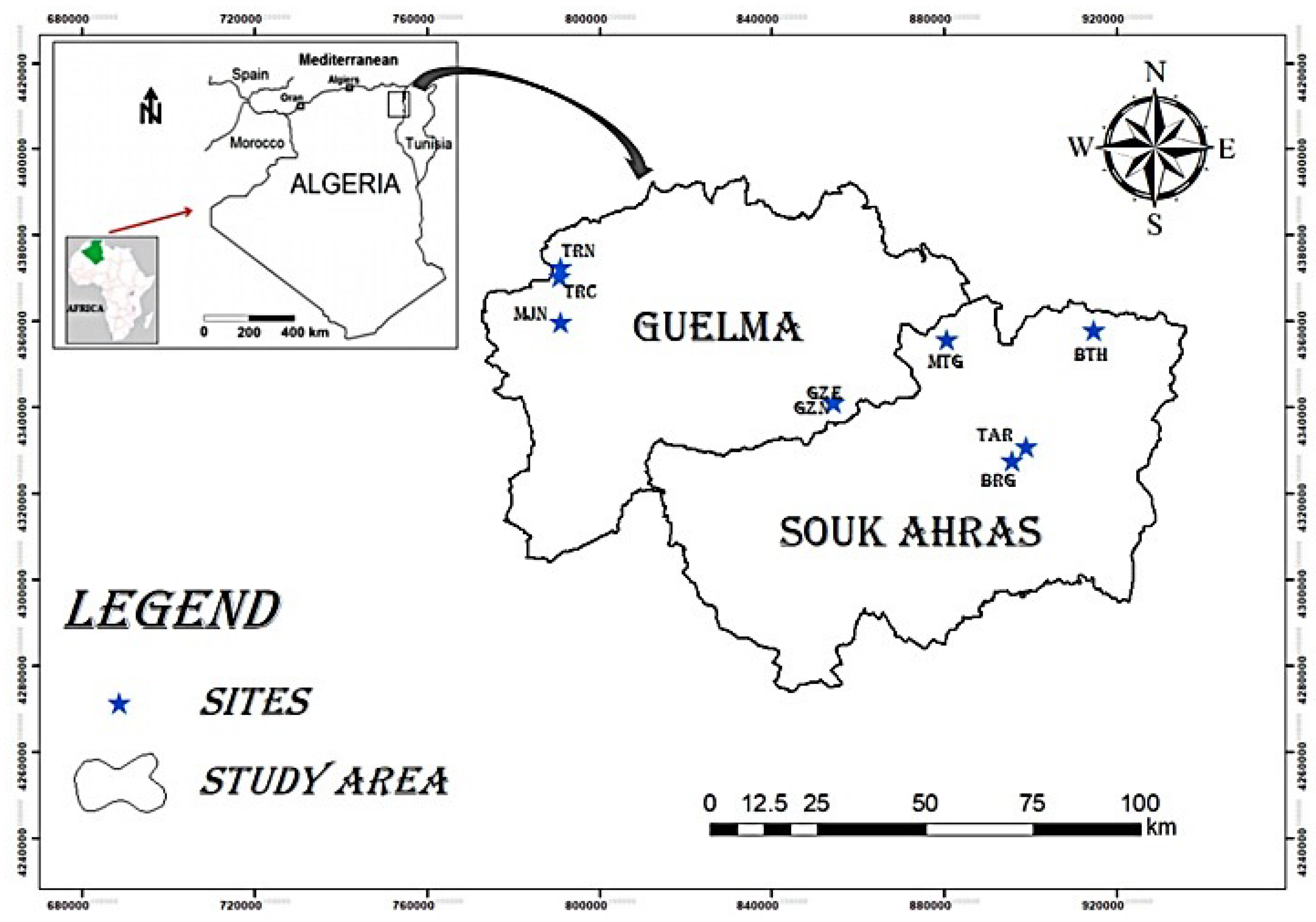
2.1. Study Area

The study area is located in northeastern Algeria (Figure 1), amidst the semi-arid zone to the south of Souk Ahras, the humid and sub-humid area to the north of Souk Ahras, and the sub-humid bioclimatic zone of Guelma [31].
It covers an area of almost 8047 km2 and features rugged terrain, with an average altitude ranging from 650 m in the south to 1000 m in the north (Table 1). Its location is indicated by a median position between the north, the highlands and the south of the country [32]. According to estimates by Kafi et al. (2015) [33], this region has approximately 199,240 ha of forest cover, primarily composed of Quercus suber L., Q. canariensis Willd., Pinus halepensis Mill. and P. pinaster Aiton [30,34], contributing to its remarkable richness. The meteorological stations of Guelma and Souk Ahras have provided annual climate readings for the period (2019–2023) with precipitation ranging between 420 and 425 mm for the GZE, GZN, TRC, TRN, and MJN wetlands and 698 and 700 mm for MTG, BTH, TAR and BRG. The average minimum temperature is around 11.5 °C, and the maximum is 26 °C.

2.2. Methodology

2.2.1. Soil Analysis

In each water pond, four soil samples were collected from different points in the form of pits measuring 30–60 cm × 50–80 cm and with a depth of 60 cm, according to the topography in each case. These four samples were combined to obtain a single representative sample per pound. They were all air-dried at room temperature for three weeks following the NF ISO 11464 methodology [35]. Subsequently, after manually separating fine soil from coarse components, they were sieved using a 2 mm round sieve.
In each sample, seven physicochemical parameters were measured: moisture using the gravimetric method by Reynolds (1970), organic matter of the moisture through incineration at 480 °C for 4 h in a muffle furnace, porosity using both apparent (DA) and real (DR) densities [36], organic carbon using the Anne de Dabin method (1965), total limestone using the volumetric method [37], electrical conductivity using a HANNA HI2315-01 conductometer and hydrogen potential using a pH meter HANNA HI22091-01, on the basis of the following definitions in Table 2:

2.2.2. Water Analysis

For the water sampling, clean 1.5-litre plastic bottles were used. One sample was collected from each water pond at 2–3 m from the shore and at a depth of 30–80 cm. To prevent gas exchange with the atmosphere, the bottles were filled underwater before screwing on the caps. For the physicochemical analysis, the samples were promptly dispatched to the laboratory. Nine physical and chemical parameters were analyzed in each sample, as Table 3 mentions:

2.2.3. Measurement of Other Environmental Variables

Concurrent with the ecological variables measured in soil and water, measurements are taken of the physiographic characteristics of the nine study ponds. These include the seasonality of their waters, the perimeter and surface area of each, their respective altitudes, slope and so on (Table 4).
On the other hand, measures are taken concerning extrinsic variables, understood as anthropogenic in origin, that is, those that can directly affect the structure, floristic composition, and functionality of the various wetlands. These are about the pressures from livestock farming, agriculture and forest fires. The values obtained for each variable are of a qualitative nature, representing characteristics rather than numerical values. All obtained values were adjusted to a numerical scale based on qualitative ranges according to different attributes (Table 4). The values assigned to each feature will be subsequently used for additional testing.

2.2.4. Floristic Study

The flora was systematically studied over two hydrological cycles (2019 and 2023), through samplings conducted twice a year (February–March and April–June) in the nine wetlands under study.
The sampling method employed involved quadrants [52], which entailed marking 9 m2 areas at the four cardinal points (North, South, East, and West). For wetlands with a surface area greater than 100 m2, three replicates were conducted for each cardinal point, following a systematic sampling method. This resulted in a total study area of 108 m2 (9 m2 × 3 replicates × 4 points) for each wetland. Conversely, for smaller water ponds (equal to or less than 100 m2), a single 9 m2 replicate was carried out for each cardinal point, amounting to a total area of 36 m2 per body of water.
For the identification of taxa, floras of Battandier (1888–1890) [53], Battandier and Trabut (1895) [54], Maire (1952–1987) [55], Quézel & Santa (1962–1963) [13], Pignatti (1982) [56], and Blanca et al. (2009) [57] were used. The African flora synonymic index (Dobignard & Chatelain, 2010–2013) [58] and the African Plant Database (APD, 2023) [59] were used to update nomenclature.
The rarity and threatened species were characterized using the Quézel & Santa (1962–1963) [13] flora categories, the global vulnerability criteria defined by the International Union for the Conservation of Nature in 1997 (Walter & Gillett, 1998) [60], the latest available red list (IUCN, 2023) [61] and our field observations.
The red list serves to emphasize the taxa most at risk of extinction and delineates priorities for policies aimed at safeguarding and conserving plant biodiversity. Additionally, we considered species with heritage significance protected by Decree No. 03–12/12–28, as well as non-cultivated plant species protected in Algeria (JORA, 2012) [62]. Biological types (sensu Raunkiaer, 1934) [63] for various taxa determined were based on information from Pignatti (1982) [56], Blanca et al. (2009) [57].
For chorological characterization, the Vascular Flora of Eastern Andalusia (Blanca et al., 2009) [57] was used.
For the endemics, the flora of Italia (Pignatti, 1982) [56], the synonymic index of Dobignard & Chatelain (2010–2013) [58] and the African Plant Database (APD, 2023) [59] were used.

2.2.5. Statistical Analysis

For the statistical analysis, Excel 2019, PAST 4.12 [64] and SPSS (Version 28.0) [65] were employed. Initially, the database containing raw data collected in the field for each measured variable was organized into Excel spreadsheets categorized by numerical or abbreviated letter codes (for taxa), some of which denote values within intervals. Subsequently, a normalization process was conducted to reduce the size of each sample and reformat the data to fit the requirements of the systems used.
As primary measures to highlight the ecological status of temporary ponds, the Shannon Diversity Index (H) and Taxonomic Distinctiveness Index (TDI) were obtained. While both reflect heterogeneity in communities, the former does so based on the number of species present and their relative abundance, i.e., based on biodiversity and the latter can also be an indicator of alterations in these communities. Therefore, it has been used to assess pressures and impacts that specific disturbances generate in terrestrial ecosystems [66].
The Taxonomic Distinctiveness Index (TDI) is a univariate metric more sensitive to changes within a population than to species diversity and appears to be less influenced by sample size, making it potentially more responsive than diversity indices themselves [66]. The traditional method to calculate this TDI is through the Delta+ index [67], but in this case, the adaptation made by Pereña et al. (2023) [68] for plant communities was used as it simplifies the calculation.
Next, a correlation analysis was conducted using the Pearson correlation coefficient to explore the relationships between these two indices and the biological and ecological variables analyzed earlier. The results are presented in tables and graphs to identify the most influential parameters affecting the ecological status of each location.
Analysis using Generalized Linear Models (GLM) was considered to correlate environmental variables with floristic diversity. However, this possibility was ruled out due to issues of non-identifiability or indeterminacy. This is because, with a number of independent variables greater than the number of observations, the estimation of GLM parameters does not have a unique solution. Consequently, there are multiple (infinite) solutions that can correctly fit the data. Such is the case that in an ordinary least squares (OLS) fit, infinite solutions can achieve an error of 0, resulting in an R2 of 1.
There was consideration of using a second type of GLM, constructing a model independently for each pair of dependent and independent variables. This approach provides the marginal effect of each independent variable on the dependent variable, without considering the impact of other dependent variables not included in that specific model. Consequently, this approach was also discarded.
Also, using the floristic data collected, the value of Priority Conservation Area (PCA) was determined, in this case referring to endemic taxa (PCA_END). To do this, the PCA value was first obtained for each site using the method proposed by Vane-Wright et al. (1991) [69]. Initially, the wetland with the highest number of species was selected for processing. These species were removed from the initial table (basic data matrix-BDM-). This process was repeated successively until all the wetlands under study were completed, including in each case the species that had not been previously considered. The values obtained in each treatment refer to the total number of identified species in the study area. Subsequently, the % of endemic taxa in each pond is obtained from the BDM. Finally, the resulting PCA values are multiplied by the % of endemic taxa, thus obtaining the value of PCA_END for each of the temporary wetlands.
Finally, to analyze the eco-floristic boundaries between ponds, understood in terms of barriers to species flow, a Matrix of Similarity Indices was developed. The statistical algorithm employed was that of Bray and Curtis, used to quantify the dissimilarity in composition between two distinct sites, based on counts within each site.
The results obtained allow us to evaluate, based on their greater or lesser similarity, the strength of the borders for the flow of flora.

3. Results

3.1. Hydro-Edaphic Characteristics

In this section, an analysis of the physicochemical properties in both soil and water samples is provided, offering insights into the findings. Table 5 and Table 6 serve as supplementary tools, complementing the information presented in the text.
These analyses reveal that the texture and structure of the soil exhibit significant porosity, with moisture and carbon contents ranging from low to moderate levels. The pH levels range between 6.3 and 7.66, indicating that the soil ranges from slightly acidic to alkaline, except in MJN, which shows a non-calcareous substrate. The total limestone percentage is considered high across all sites. Electrical conductivity varies between 0.1 mS/cm and 2.6 mS/cm. The soil and water values suggest that MTG, BTH, GZE, GZN, and TRN range from non-salinized to slightly salinized, while TAR, BRG and MJN range from moderately to highly salinized.

3.2. Other Environmental Variables Measurement

The results obtained from the analysis of physiographic characteristics are presented in Table 7, where one can observe how numerical values have been assigned to the qualitative variables based on the ranges allocated to each of them. These values will be subsequently used for the calculation of taxonomic distinctiveness.
It is notable that most of the wetlands have stagnant water, even though they are of a temporary nature, which, along with altitude (mostly between 800–1000 m above sea level), are determining factors for the floristic composition and structure, also reflected in the percentage of coverage (Wspr).
Regarding extrinsic variables, a significant level of grazing activity is observed, predominantly at levels 4 and 5, contrasting with the situation concerning agricultural activity. As for forest fires, they are practically absent in all the temporary wetlands.

3.3. Floristic Diversity

The floristic inventories conducted in the nine sampled wetlands revealed the presence of a total of 317 taxa, distributed across 204 genera belonging to 64 different botanical families (Table S1). Dominant families include Asteraceae with 50 taxa (15.77%), Fabaceae with 36 taxa (11.36%) and Poaceae with 27 taxa (8.52%). These three families collectively contribute significantly, constituting 35.65% of the total count (113 taxa), comprising over one-third of the identified flora. Apiaceae, Lamiaceae, and Caryophyllaceae are also notably well represented. Among the 64 identified families, 26 consist of a single species. A predominance of dicotyledonous angiosperms, which constitute the most significant systematic group with 249 taxa belonging to 46 families and 152 genera followed by monocotyledons comprise 65 taxa distributed across 15 families and 59 genera. Pteridophytes include 3 taxa from the Dennstaedtiaceae, Equisetaceae, and Isoetaceae families.
El-Matlegue, Guelta Zarga Effesus, and the Taoura ponds stand out as the richest areas in unusual floristic elements, each boasting over 100 species. In contrast, Taya Ranuncule distinguishes itself as the least abundant, with only 41 species.
Regarding dominant biological types, therophytes lead with 137 taxa (43.22%). Hemicryptophytes are well represented with 91 taxa (28.71%), followed by geophytes, phanerophytes, hydrophytes, and chamaephytes with 36 (11.36%), 24 (7.57%), 13 (4.42%), and 13 (4.10%) respectively. Only 4 species (1.26%) of helophytes are present, indicating very low representation.
This floristic composition encompasses transgressive species from various environments:
  • Forestry species, such as Quercus suber L., Erica arborea L., Cytisus villosus Pourr., Crataegus monogyna Jacq., Myrtus communis L., Pistacia lentiscus L. and Olea europaea L.
  • Lawn species, including both temporary-pond species (Cyperus rotundus L. subsp. rotundus, Silene laeta (Aiton) Godr., Isoetes histrix Durieu ex Bory, Typha domingensis Pers., Potentilla reptans L. and Illecebrum verticillatum L.) and therophitic pelouse species (Catapodium rigidum (L.) C.E. Hubb., Cerastium glomeratum Thuill., Ranunculus muricatus L., Medicago murex Willd., Trifolium arvense L., Plantago lanceolata L., Stellaria media (L.) Vill. and Geranium dissectum L.).
  • Hydrophytes species, such as Lemna minor L., Ranunculus aquatilis L. and Callitriche obtusangula Le Gall.
  • Hygrophytic species, such as Nasturtium officinale R. Br., Lythrum junceum Banks & Sol., Schoenus nigricans L., Juncus bufonius L., Cotula coronopifolia L., Mentha aquatica L. and Mentha pulegium L.

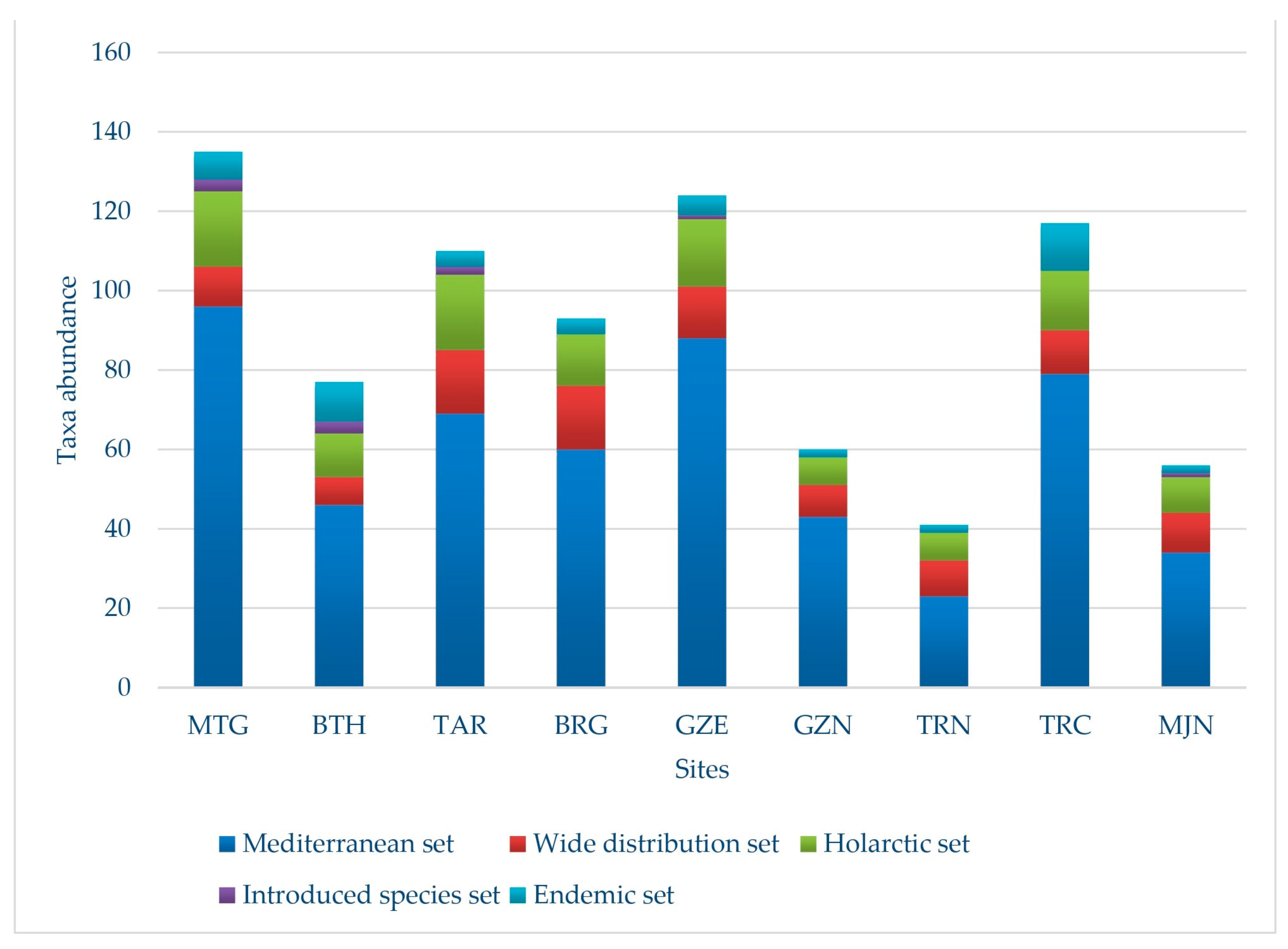
3.4. Biogeographic Distribution

The 317 identified taxa can be grouped into 5 sets according to their biogeography (Table 8; Figure 2). Different species can be found in more than one pond:
  • The Mediterranean set: the most numerous group with 210 taxa (66.25%), of which 165 correspond to strictly Mediterranean elements, 34 to euri-Mediterranean connecting elements, and 11 to Mediterranean-Atlantic connecting elements. In this group, the richest families are best represented, such as Fabaceae and Poaceae, with 26 and 15 taxa respectively, compared to the 31 taxa of the Asteraceae family.
  • The widespread distribution set: Within this classification, there are 31 taxa, constituting 9.78% of the studied flora. Among them, 12 are cosmopolitan taxa and 19 are subcosmopolitan taxa.
  • The Holarctic set: these species represent 12.93% (41 taxa) of the total flora. The paleotemperate element, with 24 taxa, is followed by the Holarctic element with 8 taxa; 6 taxa are Eurasian, and finally, 3 taxa originate from the tropics.
  • The introduced species set: 2.21% belong to this group, totaling 7 species, of which 5 are listed as introduced species, one as naturalized and another as cultivated.
  • The endemic species set: 28 regional endemic taxa are found in the study ponds, accounting for 8.83% of the total. With 11 species, i.e., 42.3% of the region’s endemic flora, Algerian-Tunisian endemic taxa are the most abundant. The families Apaiceae, Asteraceae, and Lamiaceae have the best representation with 4 taxa each, followed by Hyacinthaceae with 3 endemic species. Nine families are identified with a single endemic taxon.

3.5. Shannon Index and Its Relation to Ecological Variables

Taking the floristic data obtained from field inventories (Table S1), the Shannon Index is calculated to determine the diversity in each of the 9 studied wetlands. The test results are displayed in Table 9, where MTG exhibits the highest Shannon diversity index, followed by GZE and TRC. The lowest values correspond to GZN and TRN.
With these results, Pearson correlations have been conducted with the values of the different variables calculated in soil and water to determine if there is a relationship between floral richness and these ecological characteristics. The results are shown in Table 10 and Table 11.
The Table 10 shows how, in the case of soil-related variables, porosity has the greatest effect on floristic diversity, followed by total carbon, moisture, and organic matter, all directly linked to plant nutrition. This is unlike pH, which, in this scenario, due to its homogeneity across all ponds, does not exert any influence on wetlands flora.
In the case of water, Table 11 reveals that resistivity is the factor with the greatest influence on floral diversity, understood as an indicator of its good quality, followed by pH and ORP. On the other hand, turbidity stands in opposition, as it has the least influence on taxa, considering that most of them have a terrestrial nature.

3.6. Botanical Heritage

The rare flora in the studied area comprises 16 taxa, four of which have varying statuses on the International Union for the Conservation of Nature (IUCN) Red List [61]: Serapias lingua L. subsp. stenopetala (Maire & T. Stephenson) Maire & Weiller is classified as Critically Endangered, whereas Juncus heterophyllus L. M. Dufour, Scrophularia tenuipes Coss. & Durieu ex Coss. and Solenopsis bicolor (Batt.) Greuter & Burdet are near threatened species. There are 28 endemics or subendemics in the nine ponds that were sampled and especially those indigenous to Tunisia with 11 taxa (Algerian-Tunisian endemic) or to Morocco with 7 taxa (Algerian-Tunisian-Moroccan endemic). Not all rare species have the same heritage value, some are both endemic and rare, such as Bunium crassifolium (Batt.) Batt., Helosciadium crassipes W.D.J. Koch, Phlomis bovei de Noé and Scrophularia tenuipes Coss. & Durieu ex Coss.). Highlighting the relationship between rarity and endemism is crucial. In the broadest sense, nearly half of all endemic taxa are rare. Seven endemic taxa are identified as widely dispersed in the national territory, e.g., Cyclamen africanum Boiss. & Reut., Drimia numidica (Jord. & Fourr.) J.C. Manning & Goldblatt, Oenanthe virgata Poir. and Origanum vulgare L. subsp. glandulosum (Desf.) Ietsw. Additionally, six species are protected by algerian law: Bunium crassifolium (Batt.) Batt., Cardamine parviflora L., Cyclamen africanum Boiss. & Reut., Illecebrum verticillatum L., Phlomis bovei de Noé and Scrophularia tenuipes Coss. & Durieu ex Coss.

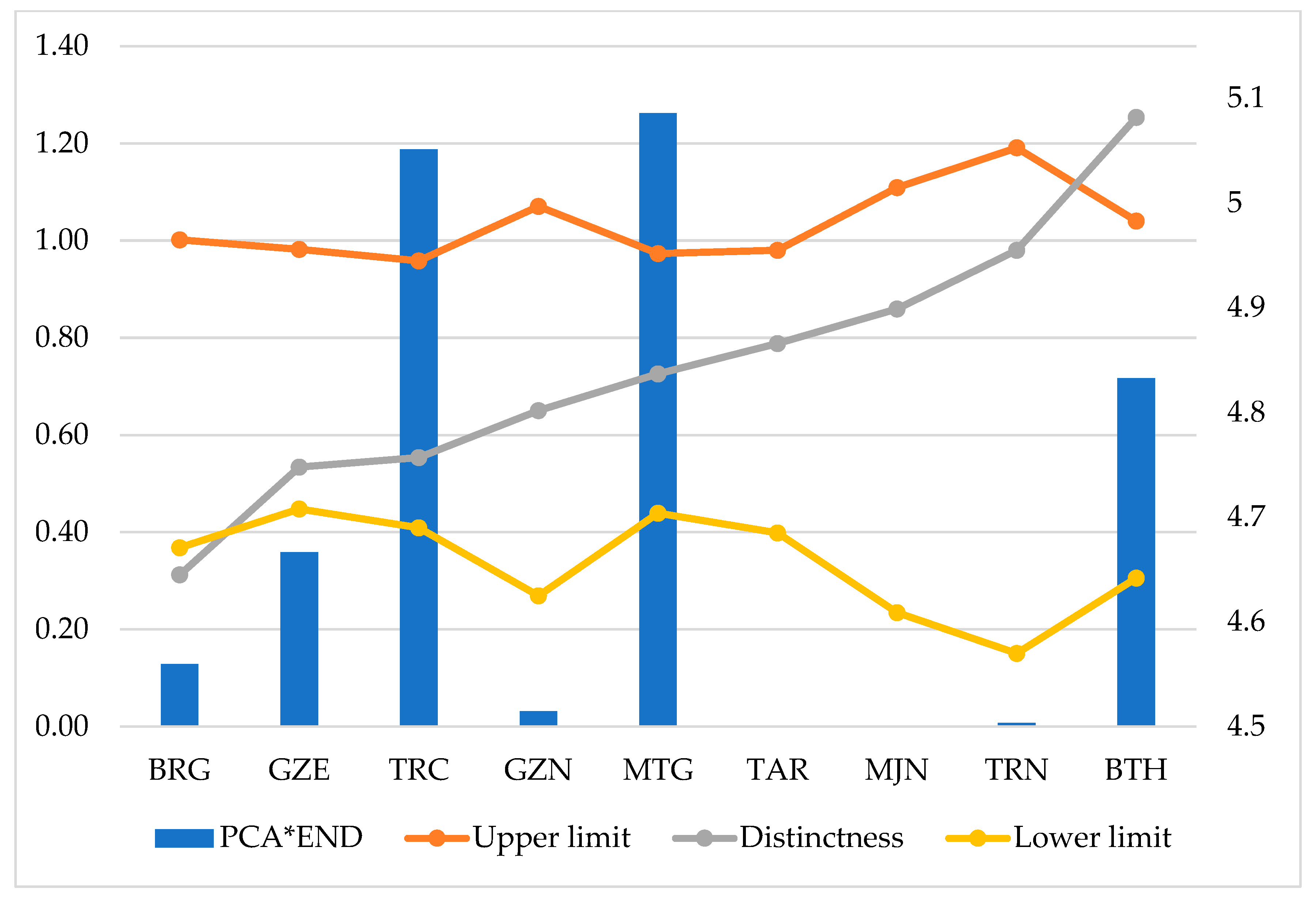
3.7. Taxonomic Distinctness (TD)

From the floristic data (Table S1), the Distinctiveness Index is calculated for each wetland, presented as the mean value within a range defined by the maximum and minimum values. The outcomes are detailed in Table 12 and Figure 3.
When comparing the results from Table 7 and Table 10, it becomes apparent that the areas showing higher values in the Shannon Diversity Index (MTG, GZE, TRC, and TAR) may not necessarily exhibit the highest Taxonomic Distinctiveness (BTH and TRN). This underscores the importance of calculating both indices. In fact, BTH demonstrates the highest TD index, thereby rendering it of particular interest for conservation purposes. Subsequently, the remaining sites exhibit less pronounced differences until reaching BRG, which demonstrates the lowest TD value, although it maintains a moderate value in the Shannon Index. In both cases, the average values fall outside the range established by the maximum and minimum TD values, potentially attributable to extrinsic disturbances (primarily of anthropogenic origin) that alter the floristic composition in one way or another.
The results obtained from the Taxonomic Distinctiveness calculation are correlated with the variables in Table 7 to determine the level of influence on the TD (Table 13).
The results highlight the negative influence of certain variables, such as forest fires, agriculture, or grazing, on DT.
These correlations indicate that agriculture and forest fires are the environmental variables with the highest coefficients, significantly shaping the distinctive character of the ponds and contributing negatively to the diversity and heterogeneity of the area. In the case of forest fires, although the obtained values are not entirely significant, they exhibit low occurrence and intensity, very homogeneous in the study area, resulting, to some extent, in an increase in their distinctive character. A similar situation occurs with agriculture, as in all cases, this activity is either non-existent or very low, except for TRC and MJN, where agricultural intensity values are moderate. The rest of the variables do not show significant results regarding the diversity and heterogeneity of the area. Section 4 will analyze the negative effects of overgrazing on species richness and abundance.

3.8. Priority Conservation Areas Based on Endemism (PCA_END)

The results obtained from the PCA calculation, the percentage of endemic taxa, and their multiplication are displayed in Figure 3, illustrating the final PCA_END value.
The TD range values and the priority conservation areas depending on endemism revealed that MTG, TRC, BTH and GZE respectively represent the prioritization conservation zones for natural heritage (Figure 4).

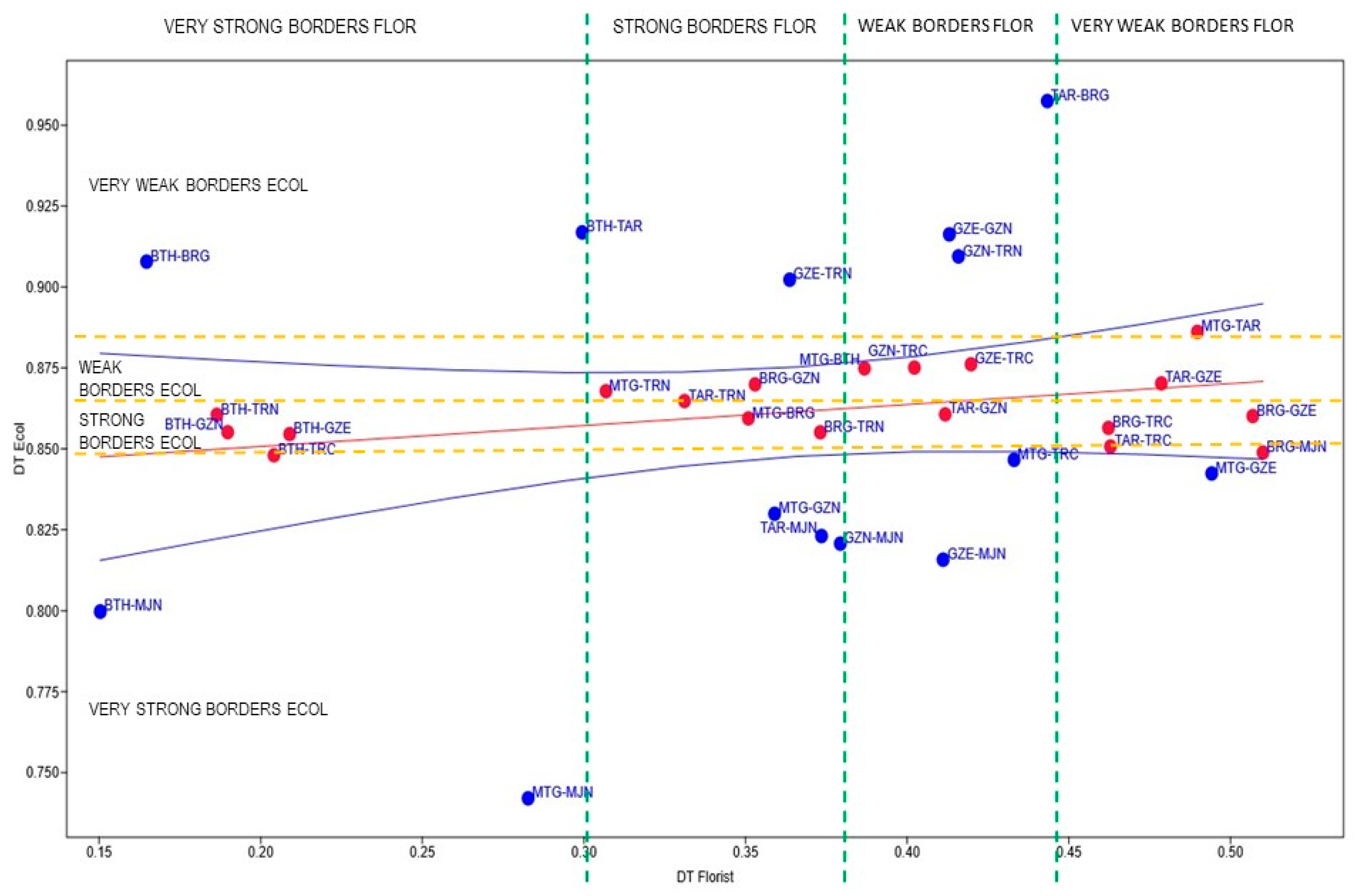
3.9. Estimation of Ecofloristic Boundaries

The results obtained from the similarity analyses among the different ponds, considering the ecological and floristic variables, are presented in Table 14 as a Matrix of Similarity Indices.
In Figure 5, pairs of sites are depicted according to the similarity values obtained. The first quartile represents very strong boundaries (0–0.25), the second quartile strong boundaries (0.25–0.5), the third quartile weak boundaries (0.5–0.75), and the fourth quartile very strong boundaries (0.75–1). The values were fitted to a regression line to subsequently identify (in red) those pairs of sites that conformed to a 95% confidence level.
Finally, 10 different situations were detected based on the strength/weakness of the eco-floristic boundaries (Table 15). The interesting information that was extracted is that out of the 4 sites marked as PCA_END, there could be a strong or very strong eco-floristic barrier in the case of BTH with another 4 sites, leading to a certain isolation and, consequently, more peculiar flora. In the case of MTG, TRC and GZE, weaker barriers or, at least, somewhat less strong ones could be identified with most of the remaining areas, allowing for the flow of species between them.

4. Discussion

4.1. Influence of Hydropedological Variables on Floristic Diversity

The results of the hydropedological analyses indicate the influence of various parameters on the floristic diversity in the 9 studied ponds, particularly the physiographic factors. Due to the calcareous substrate of geological formations rich in carbonates, which acts as a buffer for water [70], the pH values of the ponds ranged from neutral to slightly alkaline. These values fall within the same range as most Algerian wetlands [71]. Plants equipped with chlorophyll undergo photosynthesis by absorbing carbon dioxide from water and releasing oxygen, thereby causing an increase in pH. In stagnant water bodies rich in chlorophyll-bearing plants, this substantial pH elevation predominantly occurs during the day when photosynthesis is active. At night, in the absence of photosynthesis and with the release of CO2 by organisms, the pH returns to lower levels. Thus, pH variations in these aquatic environments are closely tied to the photosynthesis process. [72]. It is worth noting that pH favors the presence of certain species, such as Quercus suber, an endemic species in the Mediterranean-Atlantic region of the Mediterranean basin [73], in temporary ponds where values tend to be slightly acidic (6.3–6.72) [74]. However, soil does not pose a limiting factor, as compensatory mechanisms exist, such as the water table and the high atmospheric humidity characteristic of the Numidia region [75]. This variable has been identified as discriminant for vegetation in Mediterranean temporary wetlands [76,77,78].
Carbon dioxide, owing to its water solubility, constitutes a minor fraction of the atmosphere, exhibiting low concentrations in waters lacking organic constituents. Bicarbonate commonly assumes dominance, influenced by the intermediary pH and the interaction with substrates characterized by limited rock and mineral content. Within the context of photosynthetic processes, plants assimilate CO2, integrating carbon into organic matrices and progressively modifying the ambient CO2 concentration, as elucidated in the presented findings. This metabolic progression actively contributes to CO2 sequestration, resulting in the accumulation of organic matter at the sedimentary layers of aquatic ecosystems. Despite the favorable implications of this carbon sequestration, diminutive water bodies concurrently release carbon in the form of greenhouse gases, particularly methane (CH4), thereby attenuating the positive repercussions of carbon accrual. The magnitude of methane production is contingent upon the specific attributes inherent to the scrutinized ponds or lakes [79], as observed in the provided results.
Well-aerated soils have a high concentration of oxygen, which decreases from 100 mL/L in flooded soils and in microenvironments close to roots and plants. It’s important to note that pedofauna processes constantly alter this concentration [80]. However, generally, the concentration of dissolved oxygen in these ponds is slightly low due to turbidity induced by livestock activities. The uneven distribution of organic matter in soil samples, a crucial parameter, influences its physicochemical processes and the excessive proliferation or decrease of microorganisms is one of the causes of its degradation [40], varying according to the intensity of grazing [78].
The porosity and organic matter content in these ponds are moderate, which promotes the formation of well-structured and moist soils [40]. This creates a conducive environment for plant development by ensuring the adequate availability of water and nutrients [80,81,82]. However, it is crucial to note that this correlation can be influenced by plant types and environmental conditions [83].
Permanent saline ponds experience variations in water levels influenced by precipitation patterns (e.g., MJN). Inhabited by taxa resilient to water stress and capable of tolerating high salinity, these ponds present a physiologically dry environment due to the substantial presence of salts in the soil solution, resulting in lowered water potential and significantly reduced water availability for plants [84]. This salinity contributes to the degradation of soil structure and texture, directly impacting plant growth and productivity. It induces osmotic stress, nutrient imbalance, and toxicity, primarily attributable to elevated concentrations of Na+ and Cl [85].
The soil parameters measured play a crucial role in preserving the ecological health of Mediterranean wetland ecosystems. The soil’s diversity, characterized by texture, morphology and physico-chemical properties, influences water retention and ecosystem stability. These soils are essential actors in the genesis and evolution of ecosystems, serving as vectors for vital nutrients. Their spatiotemporal dynamics, shaped by topography, parent rock, seasonal moisture variations and vegetation, escape the direct influence of the Mediterranean climate. To sustain the stability and ecological health of these habitats, sustainable management requires a thorough understanding of these parameters, considering anthropogenic pressures and frequent wildfires [86].

4.2. Floristic and Phytogeographical Diversity

The floristic richness of these ponds, totaling 317 taxa, surpasses the diversity recorded in studies by Allem et al. (2017) [19] in temporary ponds in Annaba, those conducted by Fetnaci et al. (2019) [16] in Fetzara Lake, Ali Tatar et al. (2023) [87] in peat ponds of small Kabylia and Ferchichi et al. (2014) [15] in the Mogods region (northern Tunisia). This species richness is attributed to the diversity of habitats across the 9 water ponds, comprising stagnant and flowing water ponds under humid, sub-humid, and semi-arid climates, ranging in altitude from 500 m above sea level to 1100 m above sea level [30].
Regarding biological types, the therophytes, comprising 136 taxa, are the dominant ones in the studied ponds. The prevalence of annual species reflects the communities’ adaptation to seasonal variations [88,89], favoring short-cycle species that invest more in sexual reproduction than in vegetative development [14]. Hemicryptophytes, associated with moist environments rich in organic matter, are well-represented with 90 taxa [90,91]. This diversity can also be explained by the significance of soil microflora [16].
The analysis of the main chorological types confirms that these ponds belong to the Mediterranean floristic community, in accordance with Quézel’s observations (2002) [92] for all Northern African countries. The predominance of the Mediterranean element (66.25%) is particularly similar to that of Algerian [16,19,77] and Tunisian [4,15] ponds.
Most of the identified endemic species belong to the hotspot known as Kabylias-Numidia-Kroumiria [1], and their count is comparable to that observed in the endemic vegetation of the Edough Peninsula (northeast Algeria) [24] and Souk Ahras (northeast-west Algeria) [30], surpassing the count observed in the wetlands of the Algerian northeast coast [16,19,87].

4.3. Conservation of Plant Heritage

The vegetation in the studied ponds is characteristic of temporary Mediterranean oligotrophic ponds. It consists of herbaceous communities with decreasing development from the humid bioclimatic stage to the semi-arid stage, transitioning from the humid Mediterranean formation to a less diversified sclerophyllous formation [30,72,76,93]. The results indicate that temporary water ponds are structured into three concentric belts based on a hydrological gradient linked to the topography (slope). The sediment grain size and immersion duration are influenced by this gradient, decreasing from the periphery towards the center. This organization promotes the coexistence of a diverse set of species, as observed in Tunisia [15], Morocco [14,76] and Sardinia [94]. This transition is pivotal in comprehending the subsequent regressions in wetland biodiversity and the emergence of xerophilic and/or pollution-indicating species, such as Cotula coronopifolia L., Erigeron bonariensis L., E. canadensis L., Lemna minor L., Oxalis pes-caprae L., Xanthium strumarium L. and Typha domingensis Pers., as well as Arctotheca calendula (L.) Levyns. that have appeared in the El Kala National Park in northeastern Algeria in response to climate modifications [95]. Species adapted to humidity have been replaced by drought-resistant species, with local conditions unable to compensate for summer water deficits, especially in mesophilic environments. Repeated droughts have surpassed a critical threshold, rendering even reputedly resilient species vulnerable, threatening flowering, pollinators and the entire food chain of wetlands [96]. Hydrophytic taxa, present in clay-sandy environments and sensitive to floods, play a key role in the vegetative development of wetlands, responding to flood-related stresses [97]. This correlation underscores the direct impact of climate change on ecosystem composition, contributing to a redistribution of species and a significant transformation of wetland characteristics, with major implications for agriculture and biodiversity [16,25].
Out of the total identified flora, there are 16 rare taxa, which represents 5.05%, and among these, there is a 21% of endemism. The presence of these heritage taxa is explained by the dynamics and functional characteristics of these humid environments [98].
In this case, the configuration of the flora appears to be influenced by various environmental parameters that impact spatial heterogeneity, conditioning the emergence of different environments (mosaics) [99]. Agriculture significantly influences floral diversity and distinctiveness (p > 0.7), aided by vegetation cover and forest fires (0.5 < p < 0.6). In contrast, overgrazing negatively affects Taxonomic Distinctiveness (TD) (p ~ 0.1). Although the annual fire risk in these areas, especially in MTG and BTH, is relatively moderate compared to other regions in Algeria [100], the transformation of the environment into almost permanent reservoirs used for fire defense or irrigation poses an unusual threat that jeopardizes this heritage, exacerbated by uncontrolled tourist development [99]. Additionally, this analysis considers this factor as the second most influential, after Agriculture, in Taxonomic Distinctiveness, preserving better-adapted species and promoting a more diverse and, therefore, resilient ecosystem [101].
It is well known that the altitude, ranging from 500 m to 1100 m, and the slope, generally moderate to steep, except in cases of TAR and BRG, affect the thermal structure of eastern Algeria [102], influencing wetland richness through temperature and photoperiodic flowering [103]. The disturbance of each of these factors influences the establishment and distribution of certain taxa [104].
Grazing favors certain competitive and opportunistic native species with a hydrophilic nature, which are unappealing to the livestock [105]. However, it drives deforestation in forest ecosystems, especially in the vicinity of wetlands [18,106].
The effects of uncontrolled grazing, observed in MTG, BTH, TAR, BRG, GZN, GZE, TRN, and MJN, manifest in the intense input of nitrogen, promoting the arrival of nitrophilic species, trampling, and the substitution of oligotrophic hydrophilic species by stress-resistant species, mostly annuals and opportunists, in temporary habitats [15,107,108,109]. Therefore, the presence of livestock can compromise the biotope through physicochemical mechanisms, altering water quality (increasing eutrophication through manure), sediments (reducing organic matter content), and vegetation cover (resulting in biomass loss due to defoliation, deposition of solid and liquid excrements, and trampling) [110].
The estimation of the eco-floristic boundaries of these ponds considers them to be “interpretation subunits” or segments of territory of physicochemical, biological, and heritage interest. These interpretation subunits are grouped in a particular manner with a confidence level of 95%, implying selective affinities among the ecosystem elements, grouping them into territorial as well as semiotic units. The four ponds in which PCA_END values are higher display a certain level of species overlap with many others, except for BTH, which exhibits strong and very strong boundaries with many of them, making it of particular interest for conservation efforts. These bordering endemics of BTH correspond less to areas of specialized hyperendemism than to extensive biogeographical zones where endemic species are locally not uncommon and may even be abundant [1].
Our study highlights the widely overlooked floristic diversity of temporary ponds in northeastern Algeria, considering the biogeographic context and various environmental factors influencing location diversity. Future research should explore additional physicochemical parameters influencing the eco-floristic boundaries of identified ponds, thereby providing valuable insights into the underlying mechanisms of biodiversity. Special attention should be given to the conservation implications associated with the identified strong boundaries, evaluating their potential impact on broader strategies for preserving temporary ponds in the region. The absence of the regular monitoring and management of human practices poses a significant threat, potentially leading to structural disruptions and the destruction of these ecosystems in the short or medium term. To address this, conservation measures tailored to the natural heritage of priority areas like MTG, TRC, BTH and GZE are essential for a high-altitude water body, with a forestry or pre-forestry vocation [111]. A systematic assessment of the ecology of these habitats is crucial for effective conservation planning. The dataset reflects the still wild and fragile state of the studied area, necessitating the implementation of socio-economic initiatives to sustain it. Given the deep ecological significance and intrinsic vulnerability of biotic communities in the region, the alarming situation and rapid decline of wetland ecosystems in northeastern Algeria, as demonstrated by this study, urgently demand the implementation of appropriate conservation measures and the informed management of anthropogenic activities [16,19,21]. Over the past two decades, it could have been feasible to facilitate the implementation of such preservation strategies, notably by designating numerous habitats as Key Biodiversity Areas (KBAs) for plants in the Mediterranean region [112] or incorporating them into the scope of Ramsar sites [98]. Additionally, considering the conservation of these areas against climate change and human pressures is crucial, further emphasizing the need for proactive measures to ensure their long-term preservation.

5. Conclusions

Amidst the pressing challenges of climate change, an in-depth study of the ecology of temporary ponds in northeastern Algeria highlights exceptional floristic biodiversity, encompassing 317 species distributed across 204 genera and 64 botanical families. However, this diversity, including endemic and protected species, is under threat from factors such as overgrazing, agropastoral activities and pollution linked to human pressure, elements that could impact floral composition in the short and medium term.
It is demonstrated how the Taxonomic Distinctiveness (TD) and Priority Conservation Areas based on Endemism (PCA_END) Indices, may be employed as powerful tools for identifying conservation-important zones based on their plant components.
The analysis of eco-floristic boundaries and the selection of priority conservation areas underscore the critical need to pay special attention to the MTG, TRC, BTH and GZE zones. Furthermore, factors such as fires, pH and precipitation have been identified as having a positive impact on biodiversity, offering crucial avenues for preserving this exceptional natural heritage and enhancing environmental health.
Therefore, it is imperative to implement targeted conservation measures and actively raise awareness among public authorities about the crucial importance of protecting these fragile ecosystems.

Supplementary Materials

The following supporting information can be downloaded at: https://0-www-mdpi-com.brum.beds.ac.uk/article/10.3390/land13020210/s1, Table S1: Checklist of taxa from the nine studied wetlands.

Author Contributions

C.H.: Contributed to the field trip, and the database collection and interpretation, and the writing of the manuscript; J.F.P.-O.: Data analysis, graphical display, and the revision of the manuscript; A.M.-H.: Methodology, writing review and editing; T.H.: Floristic identification, methodology and revision of the manuscript; Á.E.S.-T.: Data analysis, graphical display and revision of the manuscript. All authors have read and agreed to the published version of the manuscript.

Funding

This research received no external funding.

Data Availability Statement

The original contributions presented in the study are included in the article, further inquiries can be directed to the corresponding author.

Conflicts of Interest

The authors declare no conflict of interest.

References

  1. Véla, E.; Benhouhou, S. Évaluation d’un nouveau point chaud de biodiversité végétale dans le Bassin méditerranéen (Afrique du Nord). Comptes Rendus Biol. 2007, 330, 589–605. [Google Scholar] [CrossRef] [PubMed]
  2. Samraoui, B.; de Bélair, G. The Guerbes-Senhadja wetlands. Part I: An overview. Ecologie 1997, 28, 233–250. [Google Scholar]
  3. Médail, F.; Michaud, H.; Molina, J.; Paradis, G.; Loisel, R. Conservation de la flore et de la végétation des mares temporaires dulçaquicoles et oligotrophes de France méditerranéenne. Ecol. Mediterr. 1998, 24, 119–134. [Google Scholar] [CrossRef]
  4. Ghrabi-Gammar, Z.; Daoud-Bouattour, A.; Ferchichi, H.; Gammar, A.M.; Muller, S.D.; Rhazi, L.; Limam-Ben Saad, S. Flore vasculaire rare, endémique et menacée des zones humides de Tunisie. Rev. DÉcologie Terre Vie 2009, 64, 19–40. [Google Scholar] [CrossRef]
  5. Rouissi, M.; Boix, D.; Muller, S.D.; Gascon, S.; Ruhi, A.; Sala, J.; Bouattour, A.; Ben Haj Jilani, I.; Ghrabi-Gammar, Z.; Ben Saad-Limam, S.; et al. Spatio-temporal variability of faunal and floral assemblages in Mediterranean temporary wetlands. Comptes Rendus Biol. 2014, 337, 695–708. [Google Scholar] [CrossRef] [PubMed]
  6. Zouaidia, H.; de Bélair, G.; Samraoui, B. Biodiversité et écologie des mares temporaires de la Numidie orientale; Nord-est Algérien: Cas du complexe des mares Gauthier. Agrobiologia 2021, 11, 2457–2469. [Google Scholar]
  7. Rifai, N.; Khattabi, A.; Moukrim, S.; Arahou, M.; Rhazi, L. Évaluation de la dynamique de l’occupation du sol dans la zone humide RAMSAR de Tahaddart (Nord-Ouest du Maroc). Rev. DÉcologie Terre Vie 2018, 73, 142–152. [Google Scholar] [CrossRef]
  8. Chillasse, L.; Dakki, M. Potentialités et statuts de conservation des zones humides du Moyen-Atlas (Maroc), avec référence aux influences de la sécheresse. Sécheresse 2004, 15, 337–345. [Google Scholar]
  9. Perennou, C.; Beltrame, C.; Guelmami, A.; Tomàs Vives, P.; Caessteker, P. Existing areas and past changes of wetland extent in the Mediterranean region: An overview. Ecol. Mediterr. 2012, 38, 53–66. [Google Scholar] [CrossRef]
  10. Davidson, N.C. How much wetland has the world lost? Long-term and recent trends in global wetland area. Mar. Freshw. Res. 2014, 65, 934–941. [Google Scholar]
  11. Chedad, A.; Bendjoudi, D.; Guezoul, O. Biodiversité de l’avifaune aquatique d’une zone humide artificielle à Kef Doukhane (Ghardaia, Sahara Algérien). Bull. Société. Zool. Fr. 2020, 145, 383–400. [Google Scholar]
  12. Benzina, I.; Si Bachir, A.; Perennou, C. Waterbird diversity at the Sebkhet of Aures wetlands complex, North East Algeria. Ornithol. Beob. 2022, 119, 318–329. [Google Scholar]
  13. Quézel, P.; Santa, S. Nouvelle Flore de L’algérie et des Régions Désertiques Méridionales, 2nd ed.; CNRS: Paris, France, 1962–1963; pp. 1–1170. [Google Scholar]
  14. Rhazi, L.; Rhazi, M.; Grillas, P.; Khyari, D.E. Richness and structure of plant communities in temporary pools from western Morocco: Influence of human activities. Hydrobiologia 2006, 570, 197–203. [Google Scholar] [CrossRef]
  15. Ferchichi Ben Jamaa, H.; Serge, D.; Muller, S.D.; Ghrabi-Gammar, Z.; Rhazi, L.; Soulié-Märsche, I.; Gammar, A.M.; Ouali, M.; Ben Saad-Limam, S.; Daoud-Bouattour, A. Influence du pâturage sur la structure, la composition et la dynamique de la végétation de mares temporaires méditerranéennes (Tunisie septentrionale). Rev. DÉcologie Terre Vie 2014, 69, 196–213. [Google Scholar] [CrossRef]
  16. Fetnaci, I.; Beddiar, A.; Hamel, T. Le lac Fetzara (Nord-Est algérien): Biodiversité floristique et menaces potentielles. Flora Mediterr. 2019, 29, 227–245. [Google Scholar]
  17. Carabal, N.; Segura, M.; Puche, E.; Rojo, C.; Rodrigo, M.A. How the diversity of constructed wetlands improves the plankton communities discharged into a protected Mediterranean wetland. Hydrobiologia 2023, 851, 243–259. [Google Scholar] [CrossRef]
  18. Sissaoui, A.; Baba, R.; Chabi, D. Climate Change and Wetlands in Algeria: Vulnerability and Conservation issues (the case of Beni-Bélaïd wetland-Jijel). J. New Sci. CSIEA 2017, 11, 2678–2683. [Google Scholar]
  19. Allem, M.; Hamel, T.; Tahraoui, C.; Boulemtafes, A. Diversité floristique des mares temporaires de la région d’Annaba (Nord-Est Algérien). Int. J. Environ. Stud. 2017, 75, 405–424. [Google Scholar] [CrossRef]
  20. Boukeng, J.E.D. Dynamique et Services des Écosystèmes Agroforestiers Autour D’une Aire Protégée du Cameroun. Ph.D. Thesis, Laval Québec University, Québec City, QC, Canada, 2021. [Google Scholar]
  21. Belouahem-Abed, D.; Belouahem, F.; Benslama, M.; de Bélair, G.; Muller, S.D. Les aulnaies de Numidie (NE algérien): Biodiversité floristique, vulnérabilité et conservation. Comptes Rendus Biol. 2011, 334, 61–73. [Google Scholar] [CrossRef] [PubMed]
  22. Boulemtafes, A. Contribution à L’étude de la Végétation Littorale Numidienne: Phytoécologie et Conservation. Ph.D. Thesis, Badji-Mokhtar Annaba University, Annaba, Algeria, 2020. [Google Scholar]
  23. Hamel, T.; Hidalgo Triana, N.; Meddad-Hamza, A.; Boulemtafes, A.; Souilah, N.; de Bélair, G.; Salvo Tierra, A.E. Analysis of taxonomic distinctness and priority conservation areas as a basis for heritage enhancement of floristic diversity: The case of the ‘hotspot’ of the islands of Numidia (North-eastern Algeria). Mediterr. Bot. 2022, 43, 1–24. [Google Scholar] [CrossRef]
  24. Hamel, T.; Seridi, R.; de Bélair, G.; Slimani, A.; Babali, B. Flore vasculaire rare et endémique de la péninsule de l’Edough (Nord-Est algerien). Rev. Sci. Technol. Synth. 2013, 26, 65–74. [Google Scholar]
  25. de Bélair, G.; Véla, E.; Boussouak, R. Inventaire des orchidées de la Numidie (NE Algérie) sur vingt années. J. Eur. Orch. 2005, 37, 291–401. [Google Scholar]
  26. Hamel, T.; Boulemtafes, A. Découverte d’une endémique tyrrhénienne Soleirolia soleirolii (Urticaceae) en Algérie (Afrique du Nord). Flora Mediterr. 2017, 27, 185–193. [Google Scholar]
  27. Boulemtafes, A.; Hamel, T.; de Bélair, G.; Véla, E. Nouvelles données sur la distribution et l’écologie de seize taxons végétaux du littoral de la péninsule de l’Edough (Nord–Est algérien). Bull. Soc. Linn. Provence 2018, 69, 1–18. [Google Scholar]
  28. Hamel, T.; de Bélair, G.; Slimani, A.; Telailia, L.B.; Telailia, S. Nouvelle station de Pteris vittata L. (Pteridaceae) en Numidie (Algérie orientale). Acta Bot. Malacit. 2020, 45, 127–129. [Google Scholar] [CrossRef]
  29. Saci, A.; Boussaada, Z.; Hamel, T.; de Bélair, G. Première observation d’une endémique tyrrhénienne (Leucojum aestivum subsp. pulchellum, Amaryllidaceae) sur le continent africain (Algérie). Flora Mediterr. 2021, 31, 123–128. [Google Scholar]
  30. Touati, L.; Hamel, T.; Meddad-Hamza, A.; de Bélair, G. Analysis of rare and endemic flora in northeastern Algeria: The case of the wilaya of Souk Ahras. Bull. Société R. Sci. Liège. 2021, 90, 213–240. [Google Scholar] [CrossRef]
  31. Seltzer, P.; Auberty, E. Le Climat de L’algérie, 1st ed.; The Institute of Meteorology and Global Physics of Algeria: Algies, Algeria, 1946. [Google Scholar]
  32. Tlidjane, A.; Menaa, M.; Rebbah, A.C.; Telailia, S.; Seddik, S.; Chefrour, A.; Maazi, M.C. La richesse et la distribution des Amphibiens dans la région de Souk Ahras (Nord-Est de l’Algérie). Bull. Soc. Zool. 2019, 144, 179–201. [Google Scholar]
  33. Kafi, F.; Hanane, S.; Bensouilah, T.; Zeraoula, A.; Brahmia, H.; Houhamdi, M. Les facteurs déterminant la réussite de la reproduction des tourterelles des bois (Streptopelia turtur) dans un milieu agricole Nord-Africain. Rev. DÉcologie Terre Vie 2015, 70, 271–279. [Google Scholar] [CrossRef]
  34. Boukehili, K.; Boutabia, L.; Telailia, S.; Menaa, M.; Tlidjane, A.; Maazi, M.C.; Chefrour, A.; Saheb, M.; Véla, E. Les orchidées de la wilaya de souk-ahras (nord-est algérien): Inventaire, écologie, répartition et enjeux de conservation. Rev. DÉcologie Terre Vie 2018, 73, 167–179. [Google Scholar] [CrossRef]
  35. Jeannot, R.; Lemière, B.; Chiron, S.; Augustin, F.; Darmendrail, D. Guide Méthodologique Pour L’analyse des Sols Pollués, 1st ed.; BRGM: Orléans, France, 2000; p. 41. [Google Scholar]
  36. Robinson, D.A.; Thomas, A.; Reinsch, S.; Lebron, I.; Feeney, C.J.; Maskell, L.C.; Wood, C.M.; Seaton, F.M.; Emmett, B.A.; Cosby, B.J. Analytical modelling of soil porosity and bulk density across the soil organic matter and land-use continuum. Sci. Rep. 2022, 12, 7085. [Google Scholar] [CrossRef] [PubMed]
  37. Allison, L.E.; Moodie, C.D. Carbonate. Methods of Soil Analysis: Part 2 Chemical and Microbiological Properties. Am. Soc. Agron. 1983, 9, 595–624. [Google Scholar]
  38. Liu, Y.; Kumar, M.; Katul, G.G.; Feng, X.; Konings, A.G. Plant hydraulics accentuates the effect of atmospheric moisture stress on transpiration. Nat. Clim. Chang. 2020, 10, 691–695. [Google Scholar] [CrossRef]
  39. Lv, J.; Huang, Z.; Luo, L.; Zhang, S.; Wang, Y. Advances in Molecular and Microscale Characterization of Soil Organic Matter: Current Limitations and Future Prospects. Environ. Sci. Technol. 2022, 56, 12793–12810. [Google Scholar] [CrossRef] [PubMed]
  40. Gobat, J.M.; Aragno, M.; Matthey, W. Le sol Vivant: Bases de Pédologie—Biologie des Sols, 3rd ed.; Polytechnic and University Presses Romande: Romande, Italy, 2010; pp. 59–362. [Google Scholar]
  41. Teghidet, H. Etude de la Cristallisation Contrôlée de la Calcite par Voie Électrochimique. Effet des Ions Étrangers au Système Calcocarbonique sur la Nucléation-Croissance de la Calcite. Ph.D. Thesis, Pierre et Marie Curie-Paris VI University, Paris, France, 2012. [Google Scholar]
  42. Pousset, J. Engrais Verts et Fertilité des Sols, 2nd ed.; French Agricultural Group: Paris, France, 2002; pp. 53–57. [Google Scholar]
  43. Ismayilov, A.I.; Mamedov, A.I.; Fujimaki, H.; Tsunekawa, A.; Levy, G.J. Soil salinity type effects on the relationship between the electrical conductivity and salt content for 1:5 soil-to-water extract. Sustainability 2021, 13, 3395. [Google Scholar] [CrossRef]
  44. Hartemink, A.E.; Barrow, N.J. Soil pH-nutrient relationships: The diagram. Plant Soil 2023, 486, 209–215. [Google Scholar] [CrossRef]
  45. Baaloudj, A.; Ouarab, S.; Kerfouf, A.; Bouriach, M.; Hussein, A.A.; Hammana, C.; Djeneba, H.D. Use of macro invertebrates to assess the quality of Seybouse River (North-East of Algeria). Ukr. J. Ecol. 2020, 10, 60–66. [Google Scholar]
  46. Gal, F.; Ghestem, J.P. Détermination du Potentiel D’oxydoréduction dans les Eaux Proposition de Document Normative; Aquaref: Paris France, 2019; pp. 9–11. [Google Scholar]
  47. Shrestha, A.K.; Basnet, N. The Correlation and Regression Analysis of Physicochemical Parameters of River Water for the Evaluation of Percentage Contribution to Electrical Conductivity. J. Chem. 2018, 2018, 8369613. [Google Scholar] [CrossRef]
  48. Derwich, E.; Benaabidate, L.; Zian, A.; Sadki, O.; Belghity, D. Caractérisation physico-chimique des eaux de la nappe alluviale du haut Sebou en aval de sa confluence avec oued Fès. Lahryss J. 2010, 8, 101–112. [Google Scholar]
  49. Aminot, A.; Kérouel, R. Hydrologie des Écosystèmes Marins: Paramètres et Analyses; Ifremer: Brest, France, 2004; pp. 44–303. [Google Scholar]
  50. Al-hadithi, M. Application of water quality index to assess suitability of groundwater quality for drinking purposes in Ratmao–Pathri Rao watershed, Haridwar District, India. Am. J. Sci. Ind. Res. 2012, 3, 395–402. [Google Scholar] [CrossRef]
  51. Gaid, K. Traitement de L’eau poTable 1: Qualité des Eaux et Clarification, 1st ed.; ISTE Edition Ltd.: London, UK, 2022; pp. 12–178. [Google Scholar]
  52. Frontier, S. Stratégies D’échantillonnage en Écologie; Masson: Paris, France, 1983; pp. 50–494. [Google Scholar]
  53. Battandier, J.A. Flore de L’algérie: Dicotylédones; Typographie Adolphe Jourdan: Paris, France, 1888–1890; pp. 1–866. [Google Scholar]
  54. Battandier, J.A.; Trabut, L. Flore D’algérie, Contenant la Description de Toutes les Plantes Signalées Jusqu’à ce Jour Comme Spontanées en Algérie et Catalogue des Plantes du Maroc: Monocotylédones; Typographie Adolphe Jourdan: Paris, France, 1895; pp. 1–256. [Google Scholar]
  55. Maire, R. Flore de l’Afrique du Nord (Maroc, Algérie, Tunisie, Tripolitaine, Cyrénaïque et Sahara), 18th ed.; Paul Lechevalier: Paris, France, 1952–1987; pp. 1–307. [Google Scholar]
  56. Pignatti, S. Flora d’Italia, 3rd ed.; Edagricole: Bologna, Italy, 1982; pp. 1–1329. [Google Scholar]
  57. Blanca, G.; Cabezudo, B.; Cueto, M.; Lopez, C.F.; Torres, C.M. Flora Vasculair de Andalucía Oriental, 1st–4th ed.; Consejeria de Medio Ambiente. Junta de Andalucia: Seville, Spain, 2009; pp. 23–1848. [Google Scholar]
  58. Dobignard, A.; Chatelain, C. Index Synonymique de la Flore d’Afrique du Nord, 1st–5th ed.; Conservatory and Botanical Gardens of Geneve: Geneve, Switzerland, 2010–2013; pp. 8–2236. [Google Scholar]
  59. APD: African Plants Database; Conservatoire et Jardin botaniques de la Ville de Genève: Geneve, Switzerland; South African National Biodiversity Institute: Pretoria, South Africa, 2023; Available online: https://africanplantdatabase.ch/ (accessed on 25 November 2023).
  60. Walter, K.S.; Gillett, H.J. 1997 IUCN Red List of Threatened Plants. The IUCN Species Survival Commission: Gland, Switzerland; Cambridge, UK, 1998; pp. 10–862. [Google Scholar]
  61. IUCN. IUCN Red List of Threatened Plants; Version 2022-2; IUCN: Gland, Switzerland, 2023; Available online: https://www.iucnredlist.org/ (accessed on 25 November 2023).
  62. ORA, J. Décret exécutif du 18 janvier, complétant la liste des espèces végétales non cultivées et protégées. J. Off. République Algérienne 2012, 51, 1–44. [Google Scholar]
  63. Raunkiaer, C. The Life Forms of Plants and Statistical Plant Geography; Oxford University Press: London, UK, 1934; pp. 1–632. [Google Scholar]
  64. Øyvind, H.; David, A.T.H.; Paul, D.R. Past: Paleontological Statistics Software Package for Education and Data Analysis. Palaeontol. Electron. 2001, 4, 1–9. [Google Scholar]
  65. IBM Corp. IBM SPSS Statistics for Windows; Version 28.0; IBM Corp.: Armonk, NY, USA, 2021. [Google Scholar]
  66. Pérez Hernández, C.X. Distintividad taxonómica: Evaluación de la diversidad en la estructura taxonómica en los ensambles. In La Biodiversidad en un Mundo Cambiante: Fundamentos Teóricos y Metodológicos Para su Estudio; Moreno, C.E., Ed.; Universidad Autónoma del Estado de Hidalgo/Libermex: Ciudad de México, Mexico, 2019; pp. 285–306. [Google Scholar]
  67. Clarke, K.R.; Warwick, R.M. A taxonomic distinctness index and its statistical properties. J. Appl. Ecol. 1998, 35, 523–531. [Google Scholar] [CrossRef]
  68. Pereña-Ortiz, J.F.; Salvo-Tierra, Á.E.; Sánchez-Mata, D. Application of Phytosociological Information in the Evaluation of the Management of Protected Areas. Plants 2023, 12, 406. [Google Scholar] [CrossRef]
  69. Vane-Wright, R.I.; Humphries, C.J.; Williams, P.H. What to protect? Systematics and the agony of choice. Biol. Conserv. 1991, 55, 235–254. [Google Scholar] [CrossRef]
  70. Marre, A. Le Tell Oriental Algérien de Collo à la Frontière Tunisienne, Étude Géomorphologique; University Publications Office UPO: Algiers, Algeria, 1992; pp. 1–177. [Google Scholar]
  71. Aibeche, C.; Sidhoum, W.; Djabeur, A.; Kaid-Harche, M. Effet des caractéristiques physico-chimiques sur la charge microbienne de l’eau des zones humides du nord-ouest algérien: Cas du lac Télamine et de Dayet Oum Ghellaz, Oran. Alger. Alger. J. Environ. Sci. Technol. 2020, 6, 1647–1657. [Google Scholar]
  72. Hade, A. Nos Lacs, les Connaître Pour Mieux les Protéger, 1st ed.; Fides: Montreal, QC, Canada, 2003; pp. 210–221. [Google Scholar]
  73. Quezel, P. La région méditerranéenne française et ses essences forestières, signification écologique dans le contexte circum-méditerranéen. Forêt Méditerranéenne 1979, 1, 7–18. [Google Scholar]
  74. Laala, A.; Alatou, D.; Adimi, A. Predicting potential habitat suitability of Quercus suber L. in Algeria under climate change scenarios. Afr. J. Ecol. 2021, 59, 976–987. [Google Scholar] [CrossRef]
  75. Bennadja, S.; de Bélair, G.; Tlili Ait Kaki, Y. La subéraie de la Numidie orientale: Une source de biodiversité. Quad. Bot. Amb. Appl. 2013, 24, 49–53. [Google Scholar]
  76. Rhazi, L.; Grillas, P.; Mounirou Touré, A.; Tan Ham, L. Impact of land use and activities on water, sediment and vegetation of temporary pools in Morocco. Comptes Rendus Académie Sci. Life Sci.—Ser. III—Sci. Vie 2001, 324, 165–177. [Google Scholar]
  77. Jamaa, H.F.B.; Muller, S.D.; Daoud-Bouattour, A.; Ghrabi-Gammar, Z.; Rhazi, L.; Soulié-Märsche, I.; Ouali, M.; Saad-Limam, S.B. Structures de végétation et conservation des zones humides temporaires méditerranéennes: La région des Mogods (Tunisie septentrionale). Comptes Rendus Biol. 2010, 333, 265–279. [Google Scholar] [CrossRef]
  78. Bouahim, S.; Rhazi, L.; Amami, B.; Waterkeyn, A.; Rhazi, M.; Saber, E.R.; Zouahri, A.; Van Den Broeck, M.; Muller, S.D.; Brendonck, L.; et al. Unravelling the impact of anthropogenic pressure on plant communities in Mediterranean temporary ponds. Mar. Freshw. Res. 2014, 65, 918–929. [Google Scholar] [CrossRef]
  79. Oertli, B.; Frossard, P.A. Mares et Étangs: Ecologie, Gestion, Aménagement et Valorisation, 1st ed.; Polytechnic and University Presses of Romandy: Romandy, Italy, 2013; pp. 49–72. [Google Scholar]
  80. Calvet, R. Le Sol: Propriétés et Fonctions—Constitution et Structure, Phénomènes aux Interfaces, 1st ed.; France Agricole-Dunod: Paris, France, 2003; pp. 40–250. [Google Scholar]
  81. Tahiri, A.; Destain, J.; Druart, P.; Thonart, P. Propriétés physico-chimiques et biologiques des substances humiques en relation avec le développement végétal. Biotechnol. Agron. Soc. Environ. 2014, 18, 436–445. [Google Scholar]
  82. Montaigne, W.; Debon, H.; Domenach, A.M.; Roggy, J.C. Gestion durable de la fertilité des sols par l’utilisation de matières organiques: Retours d’expérience en Guyane française. Innov. Agron. 2018, 64, 71–82. [Google Scholar]
  83. Freschet, G.T.; Violle, C.; Roumet, C.; Garnier, E. Interactions Entre le sol et la Végétation: Structure des Communautés de Plantes et Fonctionnement du sol. Les Sols au Cœur de la Zone Critique: Écologie; Lemanceau, P., Blouin, M., Eds.; ISTE: London, UK, 2018; pp. 83–104. [Google Scholar]
  84. Adi, N.; Amrani, S.; Hirche, A.; Boughani, A.; Nedjraoui, D. Diversité biologique et phytogéographique pour des niveaux différents de salinité dans la région du Chott-Ech-Chergui (sud-ouest de l’Algérie). Rev. DÉcologie Terre Vie 2016, 4, 342–355. [Google Scholar] [CrossRef]
  85. Hosseini-Nasr, F.; Etesami, H.; Alikhani, H.A. Silicon Improves Plant Growth-Promoting Effect of Nodule Non-Rhizobial Bacterium on Nitrogen Concentration of Alfalfa Under Salinity Stress. J. Soil Sci. Plant Nutr. 2023, 23, 496–513. [Google Scholar] [CrossRef]
  86. Benslama, M. Les Sols du Complexe Humide de l’Algérie Nord Orientale (Formation, Organisation et Evolution). Ph.D. Thesis, National Agronomic Institute of El Harrach-Algiers, Alger, Algeria, 2007. [Google Scholar]
  87. Ali Tatar, B.; Touati, L.; Hamel, T.; Mechentel, E.; Badouna, B.; Benslama, M. Phytoécologie, dynamique et reconstitution pollinique de deux mares tourbeuses (Aoural et Ain Salhat) de la petite Kabylie orientale: Cas du bassin versant d’Oued Zhor (Nord-Est algérien). Flora Mediterr. 2023, 33, 193–213. [Google Scholar]
  88. Williams, D.D. The Biology of Temporary Waters; Oxford University Press: London, UK, 2005. [Google Scholar]
  89. Megharbi, A.; Abdoun, F.; Belgherbi, B. Diversité floristique en relation avec les gradients abiotiques dans la zone humide de la Macta (Ouest d’Algérie). Rev. DÉcologie Terre Vie 2016, 71, 142–155. [Google Scholar] [CrossRef]
  90. Belouahem-Abed, D.; Belouahem, F.; de Bélair, G. Biodiversité floristique et vulnérabilité des aulnaies glutineuses de la Numidie algérienne (NE Algérien). Eur. J. Sci. Res. 2009, 32, 329–361. [Google Scholar]
  91. Djebbouri, M.; Terras, M. Floristic diversity with particular reference to endemic, rare or endangered flora in forest formations of Saïda (Algeria). Int. J. Environ. Stud. 2019, 76, 990–1003. [Google Scholar] [CrossRef]
  92. Quézel, P. Réflexions sur L’évolution de la Flore et de la Végétation au Maghreb Méditerranéen; Ibis Press: Paris, France, 2000. [Google Scholar]
  93. Bonnet, B.; Aulong, S.; Goyet, S.; Lutz, M.; Mathevet, R. Gestion Intégrée des Zones Humides Méditerranéennes: Conservation des Zones Humides; Tour de Vallet: Arles, France, 2005. [Google Scholar]
  94. Bagella, S.; Caria, M.C.; Filigheddu, R.S.; Farris, E.E. Phytosociological analysis in Sardinian Mediterranean temporary wet habitats. Fitosocio 2009, 46, 11–26. [Google Scholar]
  95. Hamel, T.; Azzouz, Z.; Bellili, A.M.; Boutabia, L.; Telailia, S. L’arctothèque souci (Arctotheca calendula): Une nouvelle espèce exotique pour la flore algérienne. Flora Mediterr. 2020, 30, 137–142. [Google Scholar]
  96. Vennetier, M. Forêts et changement climatique. Le constat en région méditerranéenne. Sci. Eaux Territ. 2020, 3, 18–25. [Google Scholar] [CrossRef]
  97. Zouaidia, H.; de Bélair, G.; Benslama, M.; Souile-Maesch, I.; Muller, S.D. Intérêt des Characeae comme bio indicateur de la qualité des eaux: Le cas des zones humides de Numidie (Nord-Est algérien). Rev. DÉcologie Terre Vie 2015, 70, 121–133. [Google Scholar] [CrossRef]
  98. Grillas, P.; Gauthier, P.; Yavercovski, N.; Perennou, C. Les Mares Temporaires Méditerranéennes, Enjeux de Conservation, Fonctionnement et Gestion, 1st ed.; Tour du Valat: Arles, France, 2004; pp. 1–120. [Google Scholar]
  99. Zedam, A.; Khoudour, D.; Mimeche, F.A. RAMSAR wetland’s endemic flora. inventory and conservation of Chott El Hodna’s plants (Northeastern Algeria). Pak. J. Bot. 2022, 54, 1025–1032. [Google Scholar] [CrossRef] [PubMed]
  100. Meddour-Sahar, O.; Bouisset, C. Les grands incendies de forêt en Algérie: Problèmes humains et politiques publiques dans la gestion des risques. Méditerranée 2013, 121, 33–40. [Google Scholar] [CrossRef]
  101. Francisco, L.; Paul, Z. The effect of forest fire on vegetation. In Fire Effects on Soils and Restoration Strategies; Science Publishers: Enfield, NH, USA, 2009; pp. 321–322. [Google Scholar]
  102. Laala, A.; Alatou, D. Interpolation spatiale des températures mensuelles en Algérie orientale. La Météorologie 2017, 98, 45–51. [Google Scholar] [CrossRef]
  103. Ricklefs, R.E.; Relyea, R. Écologie: L’économie de la Nature, 1st ed.; De Boeck Supérieur: Louvain-la-Neuve, Belgium, 2019; pp. 190–195. [Google Scholar]
  104. Rhazi, L.; Grillas, P.; Rhazi, M.; Aznar, J.C. Ten-year dynamics of vegetation in a Mediterranean temporary pool in western Morocco. Hydrobiologia 2010, 634, 185–194. [Google Scholar] [CrossRef]
  105. Chauvel, B.; Darmency, H.; Munier-Jolain, N.; Rodriguez, A. Gestion Durable de la Flore Adventice des Cultures; Quae: Versailles, France, 2018; pp. 188–193. [Google Scholar]
  106. Médail, F.; Diadema, K. Biodiversité végétale méditerranéenne et anthropisation: Approches macro et micro-régionales. Ann. Géographie 2006, 651, 618–640. [Google Scholar] [CrossRef]
  107. Grillas, P.; Roché, J. Végétation des Marais Temporaires: Ecologie et Gestion: Conservation des Zones Humides Méditerranéennes, 8th ed.; MedWet, Tour du Valat: Arles, France, 1997; pp. 1–86. [Google Scholar]
  108. Bouahim, S.; Rhazi, L.; Amami, B.; Sahib, N.; Rhazi, M.; Waterkeyn, A.; Zouahri, A.; Mesleard, F.; Muller, S.D.; Grillas, P. Impact of grazing on the species richness of plant communities in Mediterranean temporary pools (western Morocco). Comptes Rendus Biol. 2010, 333, 670–679. [Google Scholar] [CrossRef]
  109. Hamel, T.; Boulemtafes, A.; Bellili, A.M. L’impact de surpâturage sur les subéraies de la péninsule de l’Edough (Nord-Est algérien). Geo-Eco-Trop 2019, 43, 119–128. [Google Scholar]
  110. Lefebvre, T.; Gallet, C. Impacts des grands herbivores sur la végétation des prairies et conséquences sur la décomposition de la litière. INRA Prod. Anim. 2018, 30, 455–464. [Google Scholar] [CrossRef]
  111. Touati, L. Potentiel de la Flore rare et Endémique dans le Nord-Est Algérien: Cas de la Wilaya de Souk Ahras. Utilisation de Champignons Mycorhiziens sur Opuntia maxima. Ph.D. Thesis, Badji-Mokhtar Annaba University, Annaba, Algeria, 2021. [Google Scholar]
  112. Benhouhou, S.; Yahi, N.; Véla, E. Algeria (chapter 3” Key Biodiversity Areas (KBAs) for plants in the Mediterranean region”). In Conserving Wild Plants in the South and East Mediterranean Region, 3rd ed.; IUCN & IUCN Centre for Mediterranean Cooperation: Gland, Switzerland, 2018; pp. 53–60. [Google Scholar]
Figure 1. Geographical location of the study area and sites.
Land 13 00210 g001
Figure 2. Taxa abundance per chorological group at each site. MTG: El-Matlegue; BTH: El-Batha; TAR: Taoura; BRG: Burgas Lake; GZE: Guelta Zarga Effesus; GZN: Guelta Zarga Nigricans; TRN: Taya Ranuncule; TRC: Taya Rockery; MJN: Madjen Belahriti.
Land 13 00210 g002
Figure 3. PCA_END values. MTG: El-Matlegue; BTH: El-Batha; TAR: Taoura; BRG: Burgas Lake; GZE: Guelta Zarga Effesus; GZN: Guelta Zarga Nigricans; TRN: Taya Ranuncule; TRC: Taya Rockery; MJN: Madjen Belahriti.
Land 13 00210 g003
Figure 4. The potential distribution of the values of the PCA, END and TD ranges.
Land 13 00210 g004
Figure 5. Identification of ecofloristic border types for each pair of temporary wetlands.
Land 13 00210 g005
Table 1. Geographical characteristics of the study area and sites.
CodeSiteGPS CoordinatesBiogeographical Sector [13]Altitude (m)Surface Area (m2)
MTGEl-Matlegue36°23′34″ N; 7°53′42″ EK394776
BTHEl-Batha36°25′24″ N; 8°14′39″ EK38353543
TARTaoura36°09′13″ N; 7°59′28″ EH28556352
BRGBurgas Lake36°09′10″ N; 7°58′59″ EH28352162
GZEGuelta Zarga Effesus36°17′35″ N; 7°38′42″ EC1725955
GZNGuelta Zarga Nigricans36°17′34″ N; 7°38′37″ EC17431500
TRNTaya Ranuncule36°30′55″ N; 7°05′37″ EC1940386
TRCTaya Rockery36°30′32″ N; 7°05′32″ EC11082180
MJNMadjen Belahriti36°26′09″ N; 7°05′12″ EC15015155
K3 (Numidia subsector), C1 (Constantina sector) and H2 (Constantina Highlands sub-sector).
Table 2. Physico-chemical soil parameters definitions.
Soil ParametersAbbreviationUnitDefinition
MoistureH%The amount of water in the soil that plants need for development, often correlated with air humidity. Lower soil moisture is usually associated with dry winds [38].
Organic matterOM%We can also name it organic carbon (OC). The mixture of animal and/or plant remains in various stages of decomposition defines soil organic matter (SOM), and its percentage of organic carbon directly affects its physicochemical qualities [39].
PorosityP%Depending on the soil’s moisture levels, air or water fills most of its spaces. Together, they represent porosity, a characteristic quantifying the volume of soil gaps in proportion to the total volume [40].
Total limestoneTL%Limestone, primarily constituted of calcium carbonate crystallizing in the form of rhombohedral-symmetric calcite [41], provides the calcium that enables the soil to hold nutrient reserves [42].
Electrical conductivityECmS/cmDetermined by the concentration of ions and all soluble salts present [43].
Hydrogen potentialpH Affects the availability of most nutrients. It shows the soil’s acidity through the concentration of H+ ions [44].
Table 3. Physico-chemical water parameter definitions.
Water ParametersAbbreviationUnitDefinition
Hydrogen potential pH Affected by various natural factors, such as rock type, soil structure, and human activity [45].
Oxidation-reduction potentialORPMvReflected in the redox potential of water, which establishes the ability of a chemical species to gain or lose electrons. It helps to improve the understanding of aquatic chemistry and to estimate the equilibrium behavior of chemical species [46].
Dissolved oxygenDOmg/LMeasures the naturally dispersed oxygen in water. Its values should be above 4 mg/L to ensure a healthy aquatic environment and support the activity of microorganisms [47].
Electrical conductivity ECµS/cmMeasures the ease with which water can transport an electric current, therefore; it is a crucial factor in stagnant water dynamics. It increases with the concentration of ionized minerals [48]
Resistivity ρMΩ·cmA measure in which electric charges in particles within a medium move under the influence of a potential difference, so is, sometimes, preferred to a conductivity value in low-conductivity measurements, such as ultrapure water [49].
Total dissolved solids TDSmg/LNaturally occurring pollutants that affect the color, total alkalinity and water conductivity in aquatic ecosystems which could be harmful with higher values [50].
Salinity SPSURepresents the weight and content of dissolved salts in the water and is the ideal indicator of freshwater and saltwater mixtures, all of them using a professional multiparameter device, the HANNA HI9829
TemperatureT°CAffected by various natural factors, such as rock type, soil structure and human activity [45].
Turbidity TNTUAccording to Gaid (2022) [51], it is linked to the concentration of suspended solids. It is a characteristic that fluctuates depending on colloidal substances (clays, rock fragments, bacteria, etc.) or humic acids (plant degradation). Significant water turbidity reduces transparency, subsequently decreasing the amount of solar energy that can enter the water and be utilized for photosynthesis by aquatic life. It was measured using an AQUA LYTIC AL450T-IR turbidimeter.
Table 4. Environmental characteristics measured.
CharacteristicAbbreviationScale and Ranks
Temporality and faciesTmp and facsst = temporary stagnation (1), sp = permanent stagnation (2), cp = permanent current (3), ct = temporary current (4).
Perimeter (m)Per (m)1 = <100, 2 = 100–200, 3 = 201–300, 4 = 301–500, 5 = >500
Surface area (m2)Sur (m2)1 = <300, 2 = 300–700, 3 = 701–1500, 4 = 1501–2000, 5 = >2000
Altitude (m)Alti (m)1 = <300, 2 = 300–600, 3 = 601–800, 4 = 801–1000, 5 = >1000
SlopeSlo1: none, 2: <15%, 3:15–30%, 4: >30%
Depth (cm) Dep (cm)1 = < 25, 2 = 25–50, 3 = 51–75, 4 = 76–100, 5 = >100
ExposureExpo1 = North, 2 = South, 3 = West, 4 = North-east, 5 = North-west, 6 = South-east
Woody and herbaceous species cover rateWspr1 = <5%, 2 = 5–10%, 3 = 10–25%, 4 = 25–50%, 5 = 50–100%
Grazing, fire and agricultural activityGra, Fire and Agr1 = absent, 2 = minimal activity, 3 = slight activity, 4 = medium activity, 5 = very significant activity
Table 5. Physico-chemical soil parameters.
SiteH (%)OM (%)P (%)TC (%)TL (%)EC (mS/cm)pH
MTG2.23410.17524.690.73822.0750.16.3
BTH2.88113.28423.580.92422.1180.16.72
TAR4.78613.90824.913.56724.7830.87.53
BRG4.9113.33426.273.44424.551.157.48
GZE4.3148.42326.367.74924.950.47.51
GZN6.137.22328.830.61524.7750.37.66
TRN3.818.20929.61.10720.8750.16.54
TRC4.55616.43928.235.41221.2750.36.75
MJN7.56810.51628.113.32102.67.35
H (%): Moisture; OM (%): Organic matter; P (%): Porosity; TC (%): Total carbon; TL (%): Total limestone; EC (mS/cm): Electrical conductivity.
Table 6. Physico-chemical water parameters.
SitepHORP (mV)DO (mg/L)EC (µS/cm)ρ (MΩ·cm)TDS (mg/L)S (PSU)T (°C)T (NTU)
MTG7.17210.31.581240.0081620.0620.0111.6
BTH7.22481.441470.0041710.1114.1910.27
TAR7.58308.41.55529.670.002264.330.2622.9719.26
BRG7.79157.52.09490.50.0022450.2423.0364.2
GZE7.71110.54.5413250.00086620.6715.762.38
GZN7.74118.64.729880.0014940.4915.28146
TRN7.686.64.284180.00242090.214.865.07
TRC7.43108.64.772150.00471080.112.3868.1
MJN10.1830.34.5641970.000220992.2517.815.31
ORP (mV): Oxidizing or reducing qualities of an aquatic environment; DO (mg/L): Dissolved oxygen; EC (µS/cm): Electrical conductivity; ρ (MΩ·cm): Resistivity; TDS (mg/L): Total dissolved solids; S (PSU): Salinity; T (°C): Temperature; T (NTU): Turbidity.
Table 7. Quantitative values of other environmental variables.
SiteTemp and FacsPer Sur Alti SlopDpthExpWsprGrazAgrFir
MTG11142315313
BTH23541144522
TAR33542325512
BRG24542425522
GZE12333164312
GZN12331364422
TRN11244353412
TRC31154354342
MJN23522534542
Temporality and facies: Temp & facs; Perimetre: Per; Surface area: Sur; Altitude: Alti; Slope: Slop; Depth: Dpth; Geographical Exposure: Exp; Woody and herbaceous species cover rate: Wspr; Grazing, Fires & Agricultural activity: Graz, Fir & Agra. MTG: El-Matlegue; BTH: El-Batha; TAR: Taoura; BRG: Burgas Lake; GZE: Guelta Zarga Effesus; GZN: Guelta Zarga Nigricans; TRN: Taya Ranuncule; TRC: Taya Rockery; MJN: Madjen Belahriti.
Table 8. Taxa abundance per chorological group at each site.
Chorological TypesMTGBTHTARBRGGZEGZNTRNTRCMJN
Mediterranean964669608843237934
Widespread distribution107161613891110
Holarctic191119131777159
Introduced species332010001
Endemic71044522122
Table 9. Shannon Index.
SiteMTGGZETRCTARBRGBTHGZNMJNTRN
Shannon_H (S = ACE)38.6535.8234.5332.227.7823.5919.0918.0213.96
Table 10. Correlations between the Shannon Index and Physico-chemical soil parameters.
H (%)OM (%)P (%)C (%)CL (%)CE (mS/cm)pH
Correl Shannon_H−0.457940.40123−0.553930.491780.16373−0.27482−0.10743
Table 11. Correlations between the Shannon Index and Physico-chemical water parameters.
PHORP (mV)OD (mg/L)CE (µS/cm)ρ (MΩ·m)TDS (mg/L)S (PSU)T (°C)T (NTU)
Correl Shannon_H−0.440110.43611−0.33878−0.376570.52755−0.37636−0.379260.25246−0.14978
Table 12. Taxonomic Distinctness Index values (including upper and lower limits).
BRGGZETRCGZNMTGTARMJNTRNBTH
Upper limit4.9654.9564.9454.9974.9524.9555.0155.0534.983
Distinctness4.6454.7484.7574.8024.8374.8664.8994.9555.082
Lower limit4.6714.7084.694.6254.7044.6854.6094.574.642
Table 13. Correlations between TD index and environmental variables. [Fir: Fires, Slop: Slope, Exp: Geographical Exposure, Alt: Altitude, Agra: Agricultural activity, per: Perimeter, Temp & facs: Temporality and facies, Sur: Surface, Wspr: Woody and herbaceous species cover rate, Dpth: Depth, Graz: Grazing].
FirExpAltiAgraPerTemp & FacsSurWsprSlopDpthGraz
Correl DT index−0.58220.4278−0.4310−0.74740.00450.23150.0839−0.51080.35050.4927−0.1144
value0.09990.25060.24670.02060.99070.54890.830.15990.35510.17780.7694
Table 14. Ecological and Floristic Variables-Based Similarity Index Matrix.
FloristMTGBTHTARBRGGZEGZNTRNTRCMJN
MTG10.386792450.489795920.350877190.494208490.358974360.306818180.433070870.28272251
BTH0.3867924510.299465240.164705880.208955220.189781020.186440680.204081630.15037594
TAR0.489795920.2994652410.443349750.478632480.411764710.331125830.46288210.37349398
BRG0.350877190.164705880.4433497510.506912440.352941180.373134330.462264150.51006711
GZE0.494208490.208955220.478632480.5069124410.413043480.363636360.419753090.41111111
GZN0.358974360.189781020.411764710.352941180.4130434810.415841580.402234640.37931034
TRN0.306818180.186440680.331125830.373134330.363636360.4158415810.40.43298969
TRC0.433070870.204081630.46288210.462264150.419753090.402234640.410.4
MJN0.282722510.150375940.373493980.510067110.411111110.379310340.432989690.41
EcologMTGBTHTARBRGGZEGZNTRNTRCMJN
MTG10.874856490.886172890.859396610.842373890.829909350.867836520.84660440.74205644
BTH0.8748564910.916903370.907880130.854562940.855136730.860545150.8480.79972772
TAR0.886172890.9169033710.957513960.870234490.860664470.864779870.850721670.8230553
BRG0.859396610.907880130.9575139610.860136350.86993160.855110290.856459330.84884628
GZE0.842373890.854562940.870234490.8601363510.916299560.90229480.876135430.81573479
GZN0.829909350.855136730.860664470.86993160.9162995610.909480680.875114780.82068933
TRN0.867836520.860545150.864779870.855110290.90229480.9094806810.912215950.78929205
TRC0.84660440.8480.850721670.856459330.876135430.875114780.9122159510.78720497
MJN0.742056440.799727720.82305530.848846280.815734790.820689330.789292050.787204971
Table 15. Scenarios based on the Strength/Weakness of Ecofloristic Borders.
VSBFSBFWBFVWBF
VWBE MTG-TAR
WBE MTG-TRN/BRG-GZNMTG-BTH/GZN-TRC/GZE TRCTAR-GZE
SBEBTH-TRN/BTH-GZN/BTH-GZETAR-TRN/MTG-BRG/BRG-TRNTAR-GZNBRG-TRC/BRG-GZE
VSBEBTH-TRC TAR-TRC/BRG-MJN
Disclaimer/Publisher’s Note: The statements, opinions and data contained in all publications are solely those of the individual author(s) and contributor(s) and not of MDPI and/or the editor(s). MDPI and/or the editor(s) disclaim responsibility for any injury to people or property resulting from any ideas, methods, instructions or products referred to in the content.

