Article

Sustainable Agroforestry Landscape Management: Changing the Game

by
Meine van Noordwijk
1,2,3,*,
Erika Speelman
4,
Gert Jan Hofstede
5,6,
Ai Farida
7,
Ali Yansyah Abdurrahim
8,9,
Andrew Miccolis
10,11,
Arief Lukman Hakim
3,11,12,
Charles Nduhiu Wamucii
13,
Elisabeth Lagneaux
1,14,
Federico Andreotti
4,15,
George Kimbowa
16,17,
Gildas Geraud Comlan Assogba
1,
Lisa Best
4,18,
Lisa Tanika
11,
Margaret Githinji
5,
Paulina Rosero
5,
Rika Ratna Sari
1,3,
Usha Satnarain
19,
Soeryo Adiwibowo
9,
Arend Ligtenberg
4,
Catherine Muthuri
20,
Marielos Peña-Claros
11,
Edi Purwanto
21,
Pieter van Oel
16,
Danaë Rozendaal
1,22,
Didik Suprayogo
3 and
Adriaan J. Teuling
13
add Show full author list remove Hide full author list
1
Plant Production Systems, Wageningen University and Research, 6700 AK Wageningen, The Netherlands
2
World Agroforestry (ICRAF), Bogor 16155, Indonesia
3
Agroforestry Research Group, Faculty of Agriculture, Brawijaya University, Jl. Veteran no 1, Malang 65145, Indonesia
4
Laboratory of Geo-Information Science and Remote Sensing, Environmental Sciences, Wageningen University & Research, 6708 PB Wageningen, The Netherlands
5
Information Technology Group, Social Sciences, Wageningen University & Research, 6706 KN Wageningen, The Netherlands
6
Centre for Applied Risk Management (UARM), North-West University, Potchefstroom 2520, South Africa
7
Applied Climatology, IPB University, Bogor 16680, Indonesia
8
Research Centre for Population, Indonesian Institute of Sciences (LIPI), Jakarta 12190, Indonesia
9
Rural Sociology, IPB University, Bogor 16680, Indonesia
10
World Agroforestry (ICRAF), 66095-903 Belém/PA, Brazil
11
Forest Ecology and Forest Management Group, Wageningen University & Research, 6708 PB Wageningen, The Netherlands
12
Faculty of Science and Technology, Universitas Islam Raden Rahmat, Malang 65163, Indonesia
13
Hydrology and Quantitative Water Management Group, Wageningen University & Research, 6700 AA Wageningen, The Netherlands
14
iES Landau, Institute for Environmental Sciences, University of Koblenz-Landau, 76829 Landau, Germany
15
CIRAD, UPR GREEN, F-34398 Montpellier, France
16
Water Resources Management, Wageningen University & Research, 6700AA Wageningen, The Netherlands
17
Faculty of Engineering, Busitema University, 236 Tororo, Uganda
18
Tropenbos Suriname, University Campus (CELOS Building), Paramaribo, Suriname
19
Environmental Policy, Department of Social Sciences, Wageningen University & Research, 6706 KN Wageningen, The Netherlands
20
World Agroforestry (ICRAF), 00100 Nairobi, Kenya
21
Tropenbos Indonesia, Bogor 16163, Indonesia
22
Centre for Crop Systems Analysis, Wageningen University & Research, 6700 AK Wageningen, The Netherlands
*
Author to whom correspondence should be addressed.
Submission received: 28 June 2020 / Revised: 21 July 2020 / Accepted: 22 July 2020 / Published: 24 July 2020
(This article belongs to the Special Issue Agroforestry-Based Ecosystem Services)

Abstract

:
Location-specific forms of agroforestry management can reduce problems in the forest–water–people nexus, by balancing upstream and downstream interests, but social and ecological finetuning is needed. New ways of achieving shared understanding of the underlying ecological and social-ecological relations is needed to adapt and contextualize generic solutions. Addressing these challenges between thirteen cases of tropical agroforestry scenario development across three continents requires exploration of generic aspects of issues, knowledge and participative approaches. Participative projects with local stakeholders increasingly use ‘serious gaming’. Although helpful, serious games so far (1) appear to be ad hoc, case dependent, with poorly defined extrapolation domains, (2) require heavy research investment, (3) have untested cultural limitations and (4) lack clarity on where and how they can be used in policy making. We classify the main forest–water–people nexus issues and the types of land-use solutions that shape local discourses and that are to be brought to life in the games. Four ‘prototype’ games will be further used to test hypotheses about the four problems identified constraining game use. The resulting generic forest–water–people games will be the outcome of the project “Scenario evaluation for sustainable agroforestry management through forest-water-people games” (SESAM), for which this article provides a preview.

1. Introduction

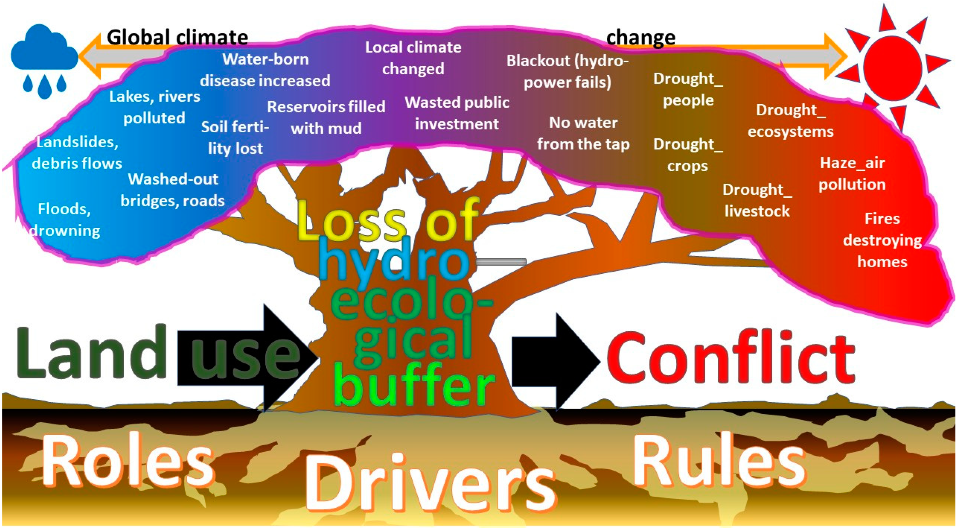
1.1. Agroforestry and the Forest–Water–People Nexus

Current understanding of the term agroforestry links plot, landscape and policy aspects of the ways farmers interact with trees [1]. We present early results and planned next steps of a new interdisciplinary research program on scenario evaluation for sustainable agroforestry management, focusses on the (agro) forest–water–people nexus and exploring how serious games can help bridge the science–policy divide, as adequate supplies of clean water are a key development challenge while the roles of trees and forest in modifying ecohydrology are context specific and often contested. A top-down policy perspective needs to be reconciled with a bottom-up farmer understanding, while social, cultural aspects may be as important as ecological, technical ones. To unpack the context dependence of past research results, a comprehensive diagnosis has to be the basis for any comparative study. We restrict ourselves here to a pan-tropical perspective.
The 2030 agenda for Sustainable Development, adopted by all United Nations member states in 2015, provides a shared blueprint for peace and prosperity for people and the planet, now and into the future [2]. As desirable as this sounds, there was a long way to go to achieve these goals even before the emergence of the SARS-CoV-2 virus showed the fragility [3] of the increasingly globalized and interdependent world. As part of the Sustainable Development agenda, land use, often a mix of forests, agroforestry, agriculture and built-up areas, has to meet many and partly conflicting needs, including the provision of food, energy, water as well as environmental protection from floods, droughts and biological extinctions. The interconnected global social-ecological system needs to be understood as a dynamic feedback system before ‘leverage points’ [4] can be used wisely to shift development to more sustainable trajectories understanding the forces working in opposite directions. By understanding the landscape as a social-ecological system [5], the ecological pattern of ‘land cover’, its hydrological consequences and the social overlay of ‘land use’ and ‘water use’ can be analyzed as part of multiple feedback loops [6].
The nexus of forest–water–people interactions is central to the landscape as social-ecological system; it is not restricted to institutional forest definitions, but relates to actual tree cover of different quantity, quality, age and spatial pattern [7]. Many authors have noted that current drivers and pressures lead to partial-interest decisions, suboptimal and often contested consequences, including disturbances of hydrological cycle and flow regimes [8,9]. Diagnosing the issue, from plot-level soil effects to continental hydro-climates [10], is a relevant first step, but unless it contributes to decisions and actions that correct the system, it remains an academic exercise. Socially, the ecological impacts can increase conflict, aggravating land mismanagement (Figure 1). Rather than trying to redress the symptoms one by one, a more incisive analysis is needed of the social-ecological system as a whole. Change will require a concurrence of local, national and international decisions translated into actions, and as such will be helped by a shared understanding of issues, commitments to achievable goals and action at appropriate temporal (immediate improvement plus long-term results) and spatial scales.
Regional planning for resilient landscape forest-water management that can adapt to change and that can incorporate a diversity of knowledge has been shown to be more effective when collective approaches for problem-solving are employed [11]. However, while active stakeholder participation has become a main approach in problem solving and solution exploration [12,13,14,15], methods are less commonly used for supporting stakeholders to explore and evaluate alternative scenarios and facilitate (social) learning [16].

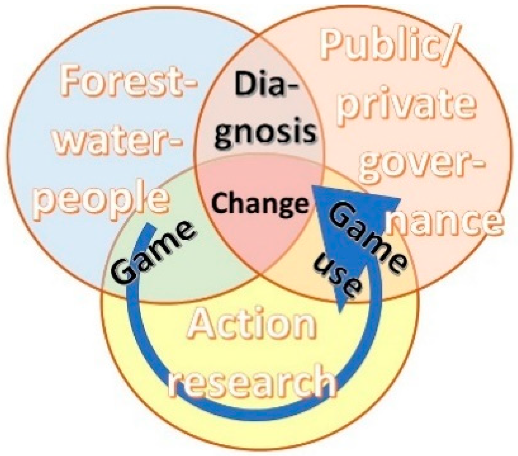
1.2. Use of Serious Games: Issues Arising

An innovative participatory approach to learn about, discuss and explore the complexity of the various dimensions of complex contested landscapes to facilitate social learning among stakeholders can be best described by the keyword ‘serious gaming’ [17]. Serious games are emerging as a valid possible intervention tool [18,19,20]. In multi-stakeholder settings, games function as (social) learning tools and boundary objects to discuss local voices and concerns. A game-based approach can stimulate participants, in a safe space, to explore system behavior through scenario evaluation and to support negotiations in local contexts. Shared experience and jointly acquired knowledge in scenario evaluation games may help in the emergence of coalitions for change in the real world. In this context, playing games has shown to provide information that can support better-informed decision making [21,22].
While the use of serious games has become increasingly popular in research and development projects, there still are relevant methodological questions that remain unanswered [23]. The development and use of these games appear to suffer from a number of drawbacks that will be addressed in this paper:
(1).
Games are commonly ad hoc, case dependent with poorly defined extrapolation domains for responsible use, and therefore less relevant of applicable in other contexts;
(2).
Games often require heavy research investment from intervention experts to be constructed in ways that are relevant for important local discussions;
(3).
Games have untested cultural limitations in where and how they can be used [24];
(4).
Game users lack clarity on where and how games relate to policy making in local and/or global issue cycles, negotiations and reforms of governance instruments.
Here, we review these four identified drawbacks of serious gaming as background to the Scenario Evaluation for Sustainable Agro-forestry Management (SESAM) program (2019–2025), which includes 15 PhD research projects, geared at credible, salient and legitimate action research (Figure 2). The overall SESAM program and the individual PhD projects within it are designed to (1) be systematic in their coverage of the pantropical forest–water–people nexus in its main manifestations and issues, using generic forest and tree cover transitions as continuum description rather than forest–agriculture dichotomies; (2) use well-established hydrological, ecological, social and economic concepts to complement local empirical knowledge; (3) be cognizant of the main dimensions in which cultural contexts of inter-human and human–nature relations vary to guide responsible game use; and (4) be explicitly adapted (or adaptable) to different stages of local and global issue (policy) cycles [25], where issues become part of a political agenda, get debated and (partly) resolved (often sowing seeds for the next issue to emerge).
These four targets are highly ambitious when taken one by one but tackling them jointly may prove to tap into synergies. In this early stage of confronting reality and our ambitions, we will describe (A) Steps to make games less ‘ad hoc’ by a selection of existing frameworks that can be used in a systemic understanding of forest–water–people nexus issues, human decision making in cultural contexts, and constructing games, (B) Link generic understanding of pantropical variation in forest–water–people configurations to the current set of landscapes/sub-watersheds that form the primary contexts and a list of emerging issues for more efficient linking of scientific, local and policy-oriented knowledge, (C) Place the set of landscapes in the known geography of cultural variation as background for exploring cultural limitations in game re-use, (D) Present a set of game prototypes that can match stages of issue cycles in policy making in local to global issue cycles, negotiation support and reforms of governance instruments.

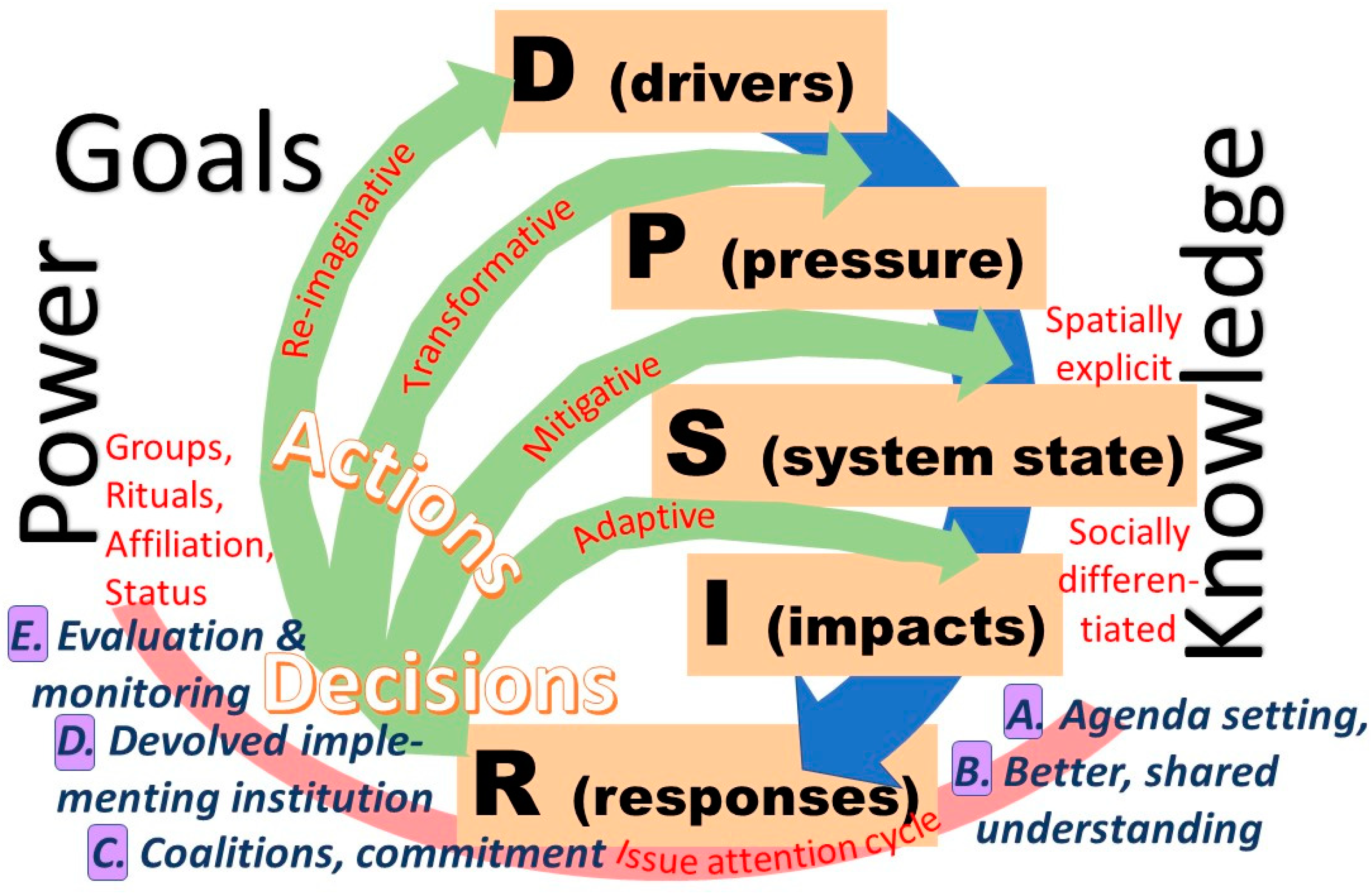
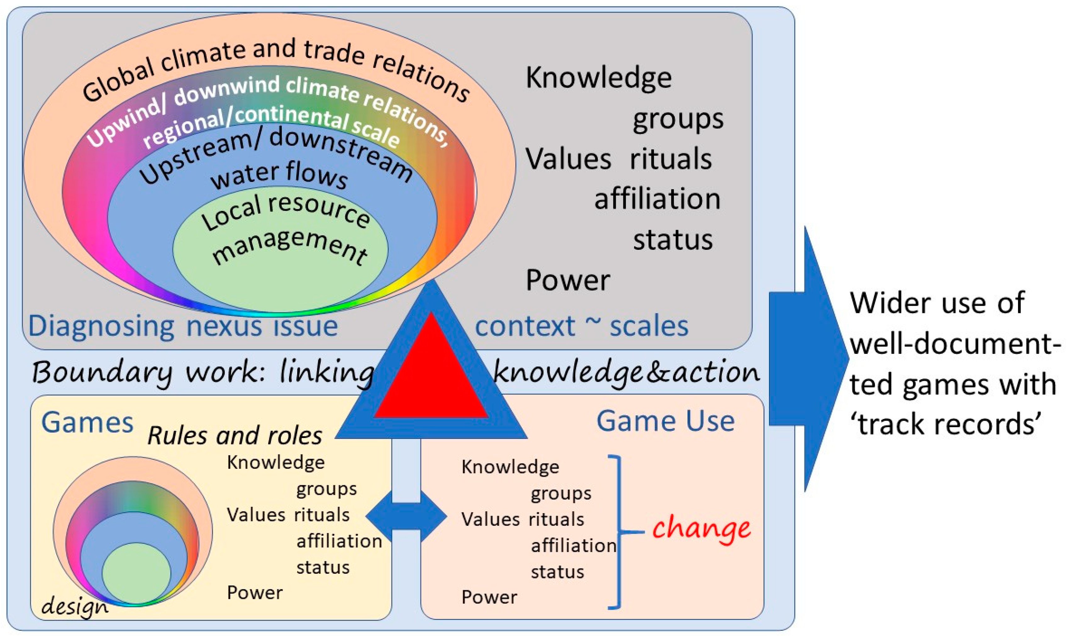
2. Frameworks for Understanding Social-Ecological System Change

A central issue in todays’ Sustainability Science is how knowledge, power and values interact in decision making and how long-term impacts and planetary responsibility can be woven into existing institutions. While there are hard trade-offs that lead to difficult choices in prioritizing one goal over another, existing space for multifunctionality is missed due to incomplete understanding of positive and negative consequences of land and water management decisions, oversimplified ideas of a forest vs. agriculture dichotomy (missing out on intermediate land uses with trees), ‘free and prior informed consent’ and inadequate stakeholder involvement. Therefore, ‘game-changing’ ways to involving diverse types of knowledge, plural values, multiple voices and heterogeneous stakes are needed. Science has always contributed to ‘environmental issue cycles’, but current concepts of “Boundary work’ across the science–policy interface include roles in agenda setting, understanding patterns and processes, exploring options and scenarios, commitment to principles and implementation decisions in a complex reality of issues and concerns. Boundary work aims for salient, credible and legitimate information and understanding [26], avoiding being ‘normative’ in presenting insights and results. Three research traditions and their tools may need to be combined for effective boundary work (Figure 3):
  • The environmental science tradition of analyzing Drivers, Pressures, System states, Impacts and Responses (DPSIR) as multi-scale phenomena that can be studied one by one, but need to be understood jointly [27,28,29].
  • The natural resource governance ‘issue cycle’ concept [30,31] in five boundary work steps that clarify the R of DPSIR: (a) Agenda setting, (b) Better and widely shared understanding of what is at stake, (c) Commitment to principles, (d) Details of operation, devolved to (newly created or existing) formal institutions that handle implementation and associated budgets, and (e) Efforts to monitor and evaluate effects (‘outcomes’); it thus relates to the ‘Responses’ part of DPSIR, and
  • The social side of human decision making based on Groups, Rituals, Affiliation, Status, Power (GRASP) [32], as will be further discussed in Section 5.
With the ‘system state’ (S) of land cover/use as starting point, one can analyze the ‘pressures’ (P) that the landscape actors respond to (e.g., food production, income generation, health, water and energy requirements, protection from disasters), or look at underlying drivers (D) that lead to the pressures (e.g., demographic trends, international markets, national policies). One can also focus on the impacts (I) that the system state has on social and ecological well-being, or on the responses (R) that are triggered. These responses can lead to a change in the S→I relationship, the often spatially explicit P→S relationship, the often-generic D→P relationships, or challenge the drivers themselves. Such decisions can be labelled as adaptive, mitigative, transformative and re-imaginative, requiring increasingly drastic change in the existing social-ecological system (deeper roots of the problem tree in Figure 1). While the ‘adaptive’ decisions can be taken individually or in small groups, the others depend on collective action (especially the mitigative ones) and policy-level institutional change.
Basic questions in any landscape approach [33] are the ‘Who?’, ‘What?’ and ’Where?’ of current land use, in a temporal perspective (‘When?’), as a start for exploring ‘Why?’ questions of drivers and pressures. Impacts (‘So what?’) are the entry point to ‘Who cares?’ stakeholder analysis, and opportunities to close the loop if those who care can directly change the who/what/where of land use, or at more fundamental level the why of drivers and pressures. These questions lead to a further elaboration of the DPSIR framework defining the breadth of the type of drivers and pressures that we may need to understand on the human side of the eco-hydrological-social system that deals with the forest–water–people nexus issues. (Figure 4).
The System-state variables (at the heart of DPSIR) deal with ecosystem structure and function on the (hydro-) ecological side, and with identity, (collective) culture, and economic indicators on the social side (Figure 4, center of the diagram). On the Impacts side, the most relevant indicators can be grouped as livelihoods and local ES, Markets and global ES. Among the pressures, migration (rather than birth rates), rights and know-how, relate to underlying drivers that include legal frameworks, demography and knowledge systems. Responses can include land and water use plans (linked to rights within a legal framework), trade reform and climate action, emphasizing relations between the local system and global change. Part of the latter are attempts to make incentive structures at the land-user level more aligned with ‘downstream’ impacts, via Payments for Ecosystem Services (PES) [34]. The recent PRIME (Productivity, Rights, complementary Investments, Market access and Ecosystem services) framework of the World Bank that has helped conceptualize forests’ contribution to poverty reduction and guide intervention design [35] is compatible with the middle hexagon in Figure 4. Further conceptual framing will be presented after the portfolio of landscapes are briefly introduced.

3. Representativeness and Diagnostic DPSIR Analysis of the SESAM Landscape Portfolio

Brief descriptions of the 13 landscapes in which SESAM will diagnose issues, develop games and test their relevance for local decision making are provided in Appendix A. In this section, we will consider the degree to which the portfolio can be expected to include major variation in pantropical manifestation of forest–water–people nexus issues and apply a DPSIR analysis to identify the major issues at stake.
A pantropical typology of forest–people interactions [36] has proposed six recognizable stages of a ‘forest transition’, starting with landscapes with >80% of core forest and human population densities below 1 to over 1000 km−2. All forest transition stages can be found in any of five ecoclimatic zones, that link to a forest water analysis, and are based on the ratio of rainfall (precipitation, P) and potential evapotranspiration (Epot). This typology separates drylands and semi-arid zones (P/Epot < 0.5; 35% of tropical area, 20% of people) from a dry–sub-humid zone (0.5 < P/Epot < 0.65; 10% of area, 11% of people). On the wetter side, we can distinguish (relatively) high ‘water towers’ with P/Epot > 0.65 and generating streamflow to lower, drier parts of the same watershed (11% of area; 15% of people), a lowland (non-water tower) humid forest zone (0.65 < P/Epot < 0.9; 19% of area, 22% of people) and a per-humid lowland forest zone (P/Epot > 0.9) with 25% of pantropical land area and 32% of its human population. Human life in the drier zones depends on rivers (or groundwater flows) that originate in wetter areas, especially in the ‘water tower’ configuration where the wetter part is higher in the landscape. All eco-climatic zones can contain all stages of the forest transition, although in the drier parts of the tropics climate and human agency are not easily disentangled as causes of low tree cover vegetation. Forest transitions are defined by a phase of declining cover of (natural) forest, an inflection point and a phase of increasing forest cover (secondary forest in landscapes with rural land abandonment and urbanization, and, more commonly, planted forests). The pantropical classification at sub-watershed level [35] forms a basis for judging pantropical representativeness of our SESAM landscapes. Summary statistics of the various SESAM landscapes (Table 1) show that the landscapes include all five ecoclimatic zones (dryland/semiarid; dry-sub-humid; water tower; humid per-humid lowland) and all six forest transition stages. On further analysis, the forest–water–people nexus issues in each of the landscapes involve plot-level aspects that relate to lack or presence of trees, hillslope and watershed hydrological relations (and associated water rights), and policies for agriculture, forestry, land-use rights (Table 2). These three issues match the three current agroforestry paradigms at plot/farm, landscape and policy scales, within a common definition of agroforestry as the interaction of agriculture and trees, including the agricultural use of trees [37].

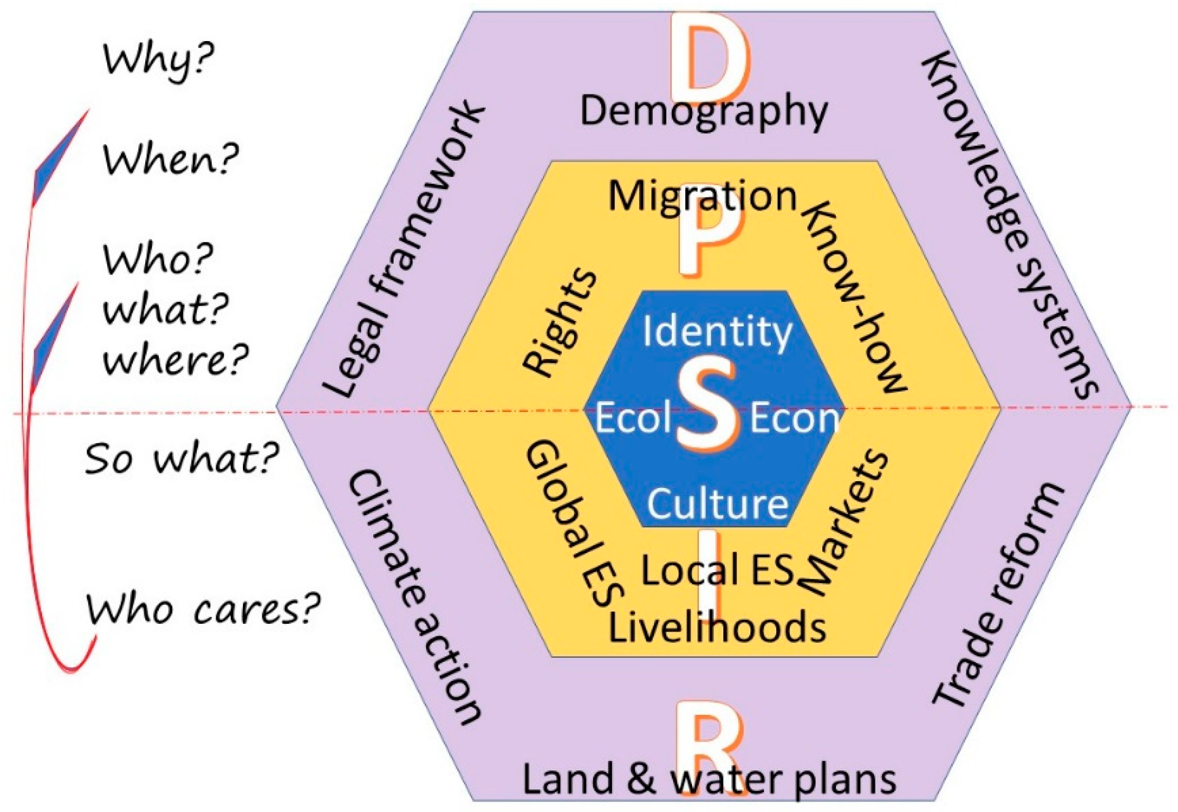
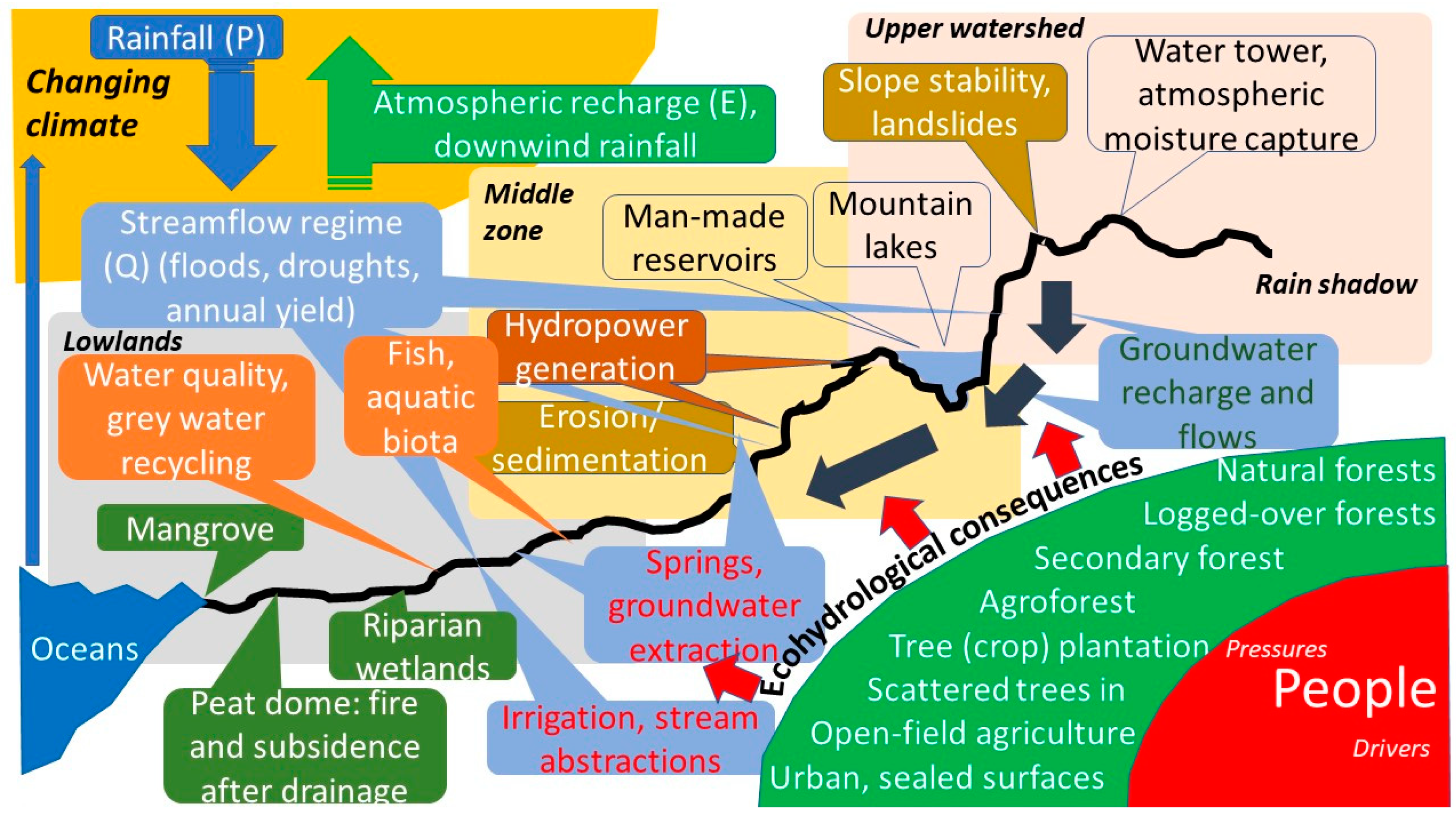
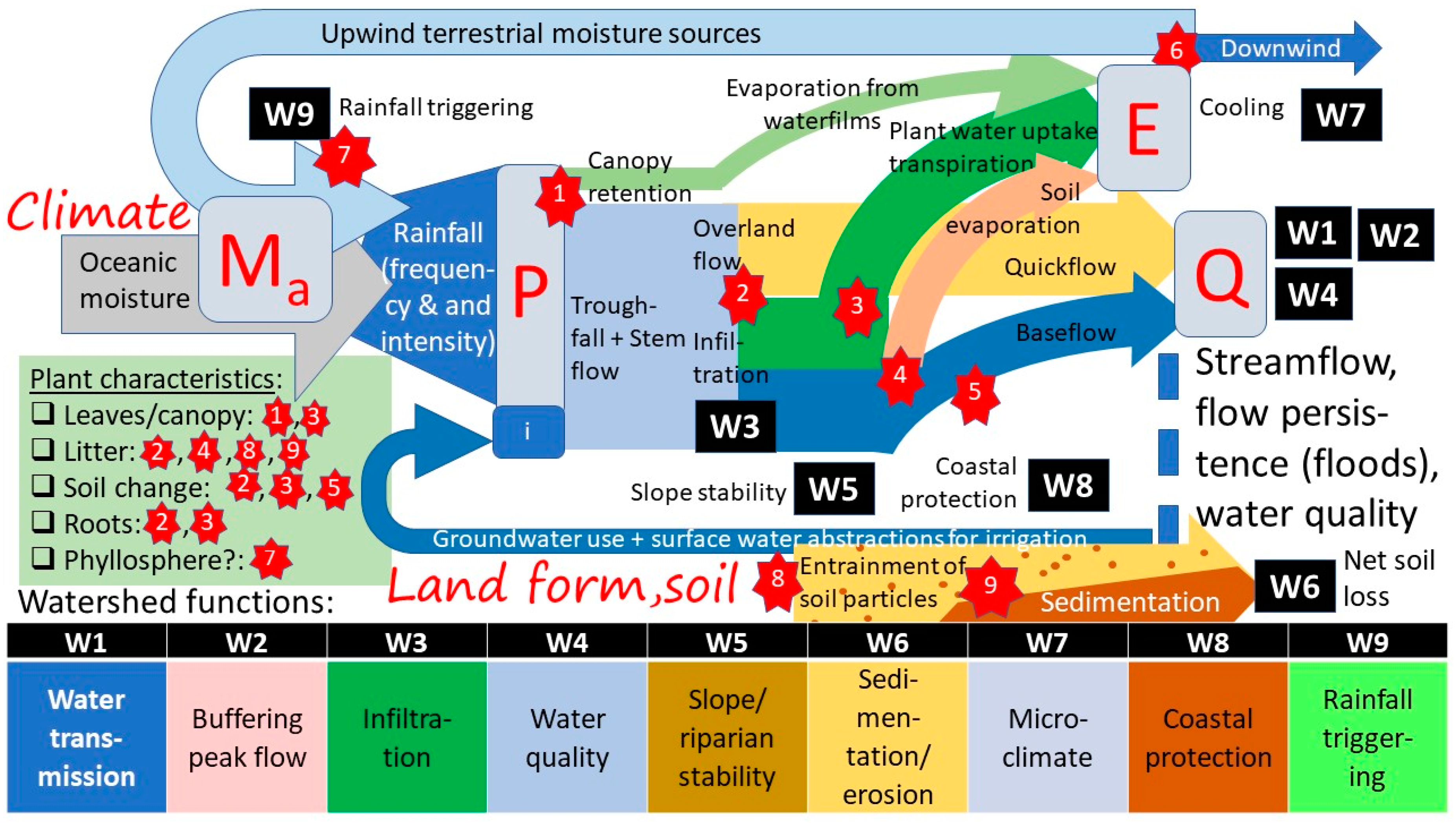
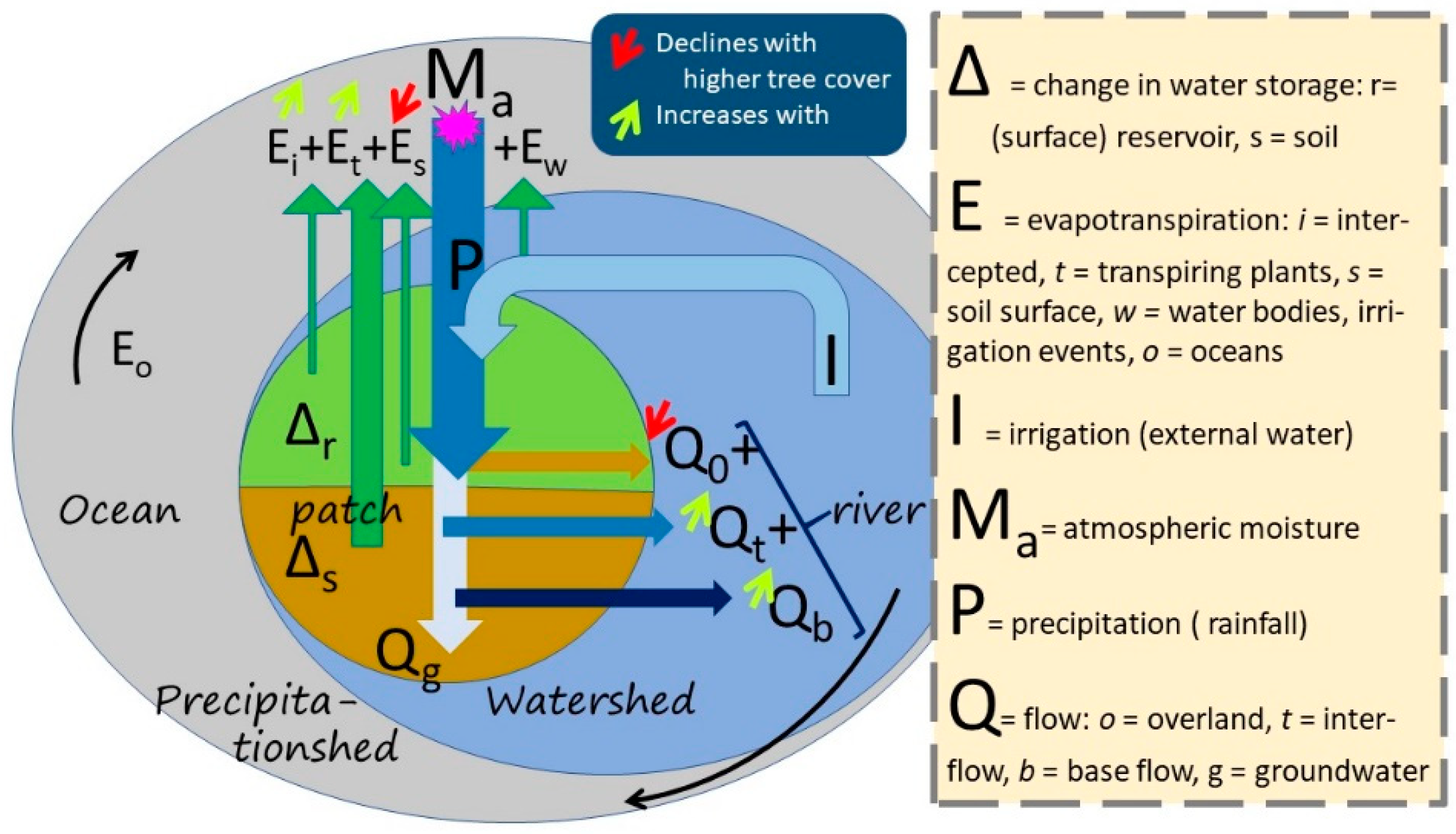
4. Unpacking the Forest–Water–People Nexus

A large number of ‘issues’ in the case studies relate to water and need to be understood in their landscape context (Figure 5). They all relate to the way water flows from mountains ultimately back to oceans, unless it follows the atmospheric ‘short cycle’ downwind route back to rainfall over land. Along the streamflow pathway, water changes in quality (sediment load, pollution), quantity (annual water yield to reservoirs or lakes), and flow regime (regularity of flow, flood risks), affecting settlements, agriculture, fisheries and human health. A major theme is the upstream versus downstream (with the ‘water tower’ configuration of freshwater sources for lowlands specifically challenging), complemented by upwind versus downwind for rainfall recycling, and specific features such as riparian wetlands and forests, peat swamp forests and mangroves protecting the coastal zone, while supporting marine fisheries. The scientific debate on the mechanisms and patterns of ‘biological rainfall infrastructure’ is undecided [6,38]. While the ‘biotic pump’ theory suggests forests cause the flow of moist air towards them, observations of windspeeds show that rainforests are associated with relatively low wind speeds that imply the ‘short cycle’ can remain relatively local, with transport distances during the mean atmospheric residence time of 8 days of hundreds rather than thousands of kilometers [39].
Where issues relate to forests and/or trees outside the forest, the cascade of processes that start with rainfall, are followed by canopy interception, infiltration into the soil or overland flow and contribution to local water storage and/or direct response of streams and rivers (Figure 6). Ecosystem structure interacts with hydro-ecological processes, jointly shaping a set of ‘ecosystem services’ that relate to benefits humans derive from well-functioning systems. A typology of nine such ‘watershed functions’ are indicated in Figure 6 and described in Table 3. These functions (or ‘services’) can be used to analyze site-specific differences between land cover types, relating the actions of roots in soil to landscape-level streamflow [40].
The principal concept in all of ecohydrology is that of the water balance, where input (precipitation P or snowmelt in cooler parts of the world) is related to two main pathways out of the system: back to the atmosphere via evapotranspiration (E) and streamflow Q (surface or groundwater flows) and to changes in the ‘buffer’ of water held inside the system (Figure 7). At timescales of a year or more this buffering can be ignored (except for interannual climate variability), but at the timescale of a rainstorm it is key to reduce downstream flooding risk [41,42].
We can now relate a typology of ‘watershed functions’ (W1W9) to an understanding of ecosystem structure and function, across the various landscapes (Table 3). Decisions on adding landscapes to the SESAM portfolio were made with this representation in mind. Probably the most contested in this list is W9, the influence of vegetation on rainfall regimes at landscape and continental scales [38,43,44,45,46]. Three of the Latin America landscapes are at the start of the Amazon rainfall recycling system, one is at the receiving end, and one in the much drier Andes range that depends on left-over atmospheric moisture. The two East African water towers are part of the complex hydro-climatic system, influencing rainfall further North (including to some extent that in the Burkina Faso landscape, along with water coming in from the Atlantic Ocean).
Beyond the ‘provisioning’ and ‘regulating’ services captured in W1…W9, there also are ‘cultural’ services based on ’relational values’ between Humans and Nature. The two interact when visits by domestic (or international) tourists to the mangroves of Nickerie district in Suriname or the mountain resorts in East Java increase pressure on freshwater resources. At the global scale the ‘Ecosystem Service’ (ES) language is currently embedded as ‘instrumental values’ in a wider ‘relational values’ paradigm on ‘Nature’s Contributions to People’ (NCP) [49]. The way cultural relations with a landscape and its forest and water aspects is expressed varies with history and religion. The springs in the upper Brantas still are sacred places, where mountain spirits are brought offerings to secure the gift of fresh water continues. On densely populated Java, the wayang tradition re-tells stories of the past. All stories start with the gunungan or mountain symbol (Figure 8), a tree of life connecting forest animals and creatures to people’s homes and lives. The flip-side, shown occasionally for dramatic effect, shows demons and fire: social conflict and mismanaging human–nature relations destroys human livelihoods. Throughout human history, perspectives on spirits, deities, personified nature or a single Almighty have been described in metaphors of words that also describe human–human relations in terms of (A) family, such as ancestors, (grand-) parents (Mother Nature), siblings, offspring, partners, in-laws), (B) neighbors, friends, business partners, (C) adversaries, competitors, armed attackers and defenders, (D) servants or (E) educators. A subset of these relations (the providing mother of NCPs and ES servants) can be interpreted as ‘instrumental’, directly supporting human goals and objectives, but even those imply that there will have to be a two-way (rather than unidirectional) relationship to maintain or support what is relevant to people because it cannot be taken for granted [50].
Across the various landscapes we can now understand that debates about increasing/decreasing forest cover and/or tree cover in agroforestry or other land uses, can have both instrumental and wider relational aspects. Technical solutions to local issues may increase problems if they do not lead to shared understanding and negotiated trade-offs. Such effects will have to be represented in applicable games at a reasonable level of detail and accuracy, and in their cultural context.
The immediate issues of public concern to which landscape management contributes (or can help solve) are very diverse among the SESAM portfolio, even though they all relate to the same water balance. Upstream on the Suriname river, increasing deforestation (gold mining) and forest degradation (logging) in the Guiana Shield will need to be managed in a better way. Increasing food security, and water security during the long dry season, depends on maintaining and restoring the flow buffering aspect of the river, along with sustained biodiversity as a basis for other forest ecosystem services beneficiaries depend on for subsistence and income. In Madre de Dios (Peru) focus is on reduced water shortages for agriculture and household use (including fruit production) in the dry season, but also on fire prevention during the dry season. In Pará State, water recycling is reduced by deforestation and land degradation and water quality undermined by chemical inputs used on large-scale monocrop plantations, pointing to the need for restorative and climate-smart agroecological practices including agroforestry. In the Ketapang peatlands (Indonesia), reducing public health impacts of haze episodes due to peat-swamp forest fire may align with an interest in reducing agricultural damage due to flooding during the rainy season by restoring the water storage capacity of peat domes and reducing the speed of drainage. Restoring the mangrove forest in Suriname will protect the coastal zone from saltwater intrusion and floods, while the mangrove ecosystem provides services to coastal fisheries, beyond its direct products.
Water resources management in water towers of Kenya and Uganda involves better crop selection, caution in increasing middle-zone tree densities and attention to water distribution for downstream users. It also involves reducing landslides, minimizing population displacement and deaths, loss of fertile land and famine. Reducing flooding in the downstream area during the rainy season can go hand in hand with reducing drought (severe dry Spells).
In the densely populated Brantas river basin in Indonesia, the targets are water security and water quality for domestic use and tourism, and irrigation water for dry-season paddy rice production (three or even four crops per year). Similarly, around Lake Singkarak there’s a need for increasing water availability for irrigation and hydropower during the dry season, but also a need for maintaining the local endemic fish habitat due to maintained water quality. In the Rejoso Watershed, beyond these points, reducing water use in lowland rice paddies may be needed to secure groundwater for a nearby metropole. Before using these insights, however, the cultural context needs to be considered as it may call for different ways of constructing games, despite hydro-ecological similarity.

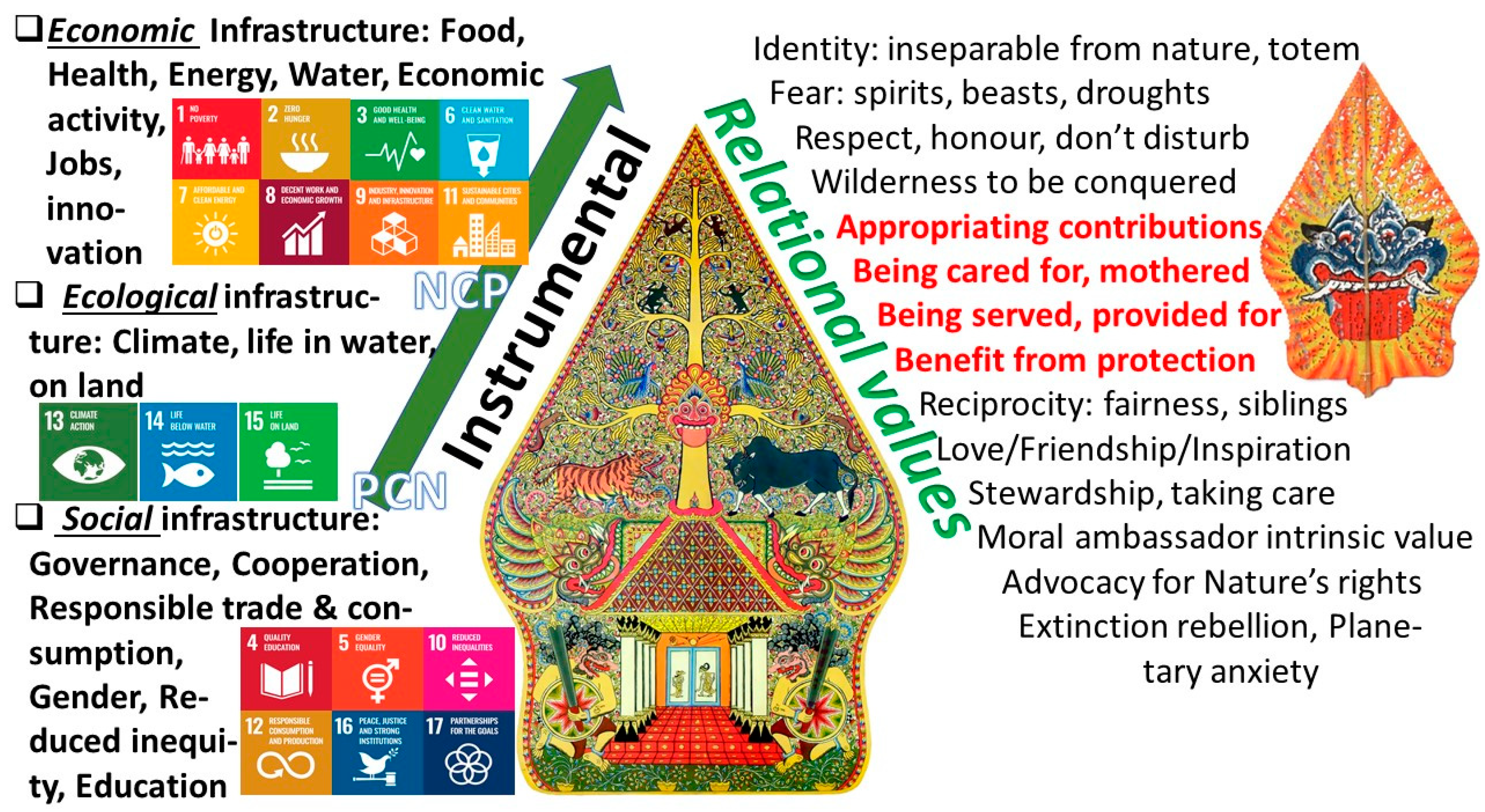
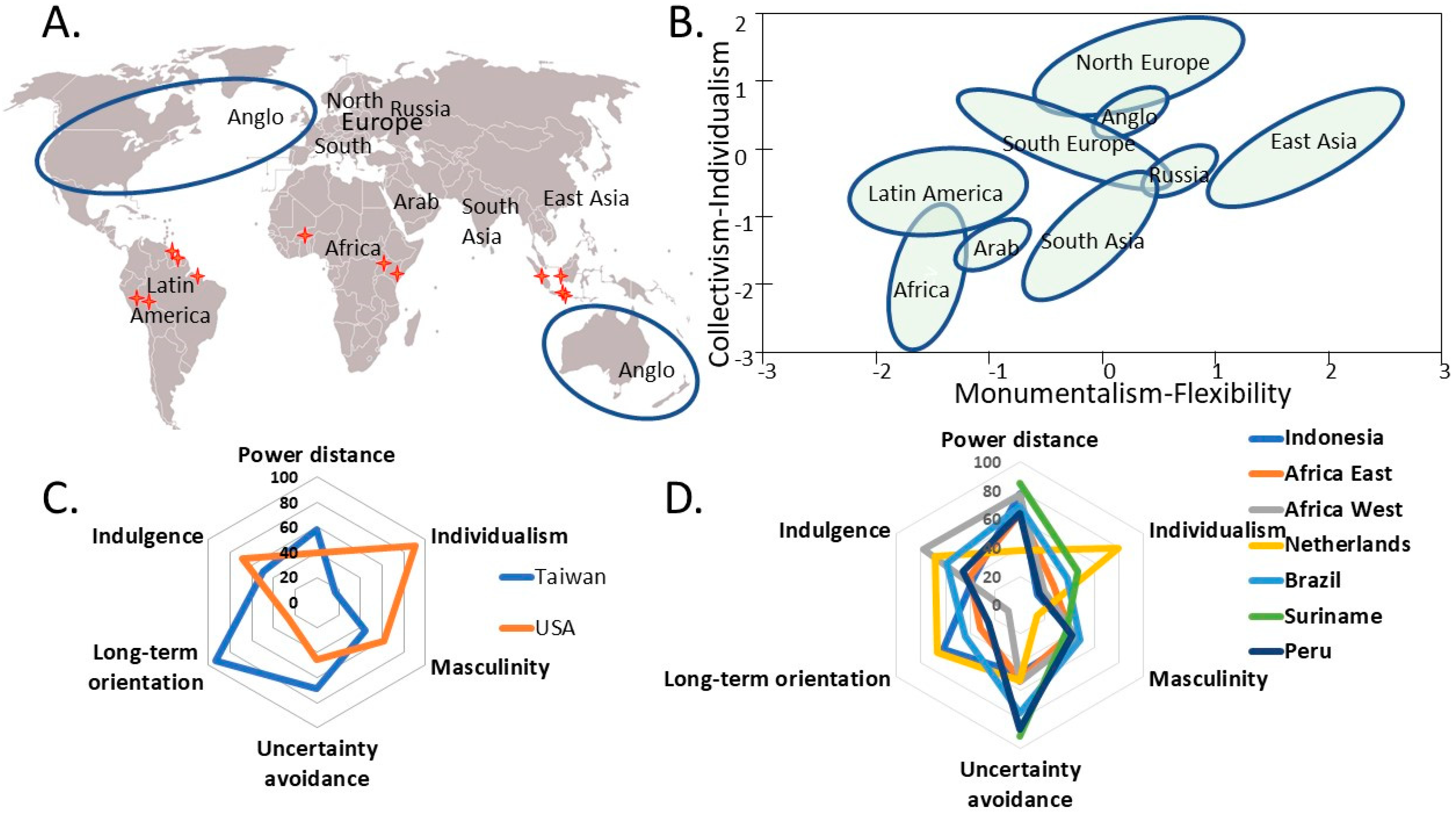
5. Cultural Diversity in Response to Forest–Water–People Nexus Issues

The response options chosen in any society and any point in time are under the influence of culture, as a layer between generic human nature and individual personality. Research on geographic variation in culture at any point in time (Figure 9A) and cultural change as part of economic development can be reconciled in identifying at least two (but up to six) main axes of variation [51]. In the simplest portrayal (Figure 9B) a collectivism–individualism axis aligns with distance to the equator, and a monumentalism-flexibility axis on which Latin America and East Asia are the bookends.
People follow any of four directions in addressing any (new) issue, with preferences depending on culture [54]: hierarchy (clarity on power in decision making), unleashing private initiative (aiming for efficiency and public benefits via an ‘invisible hand’), (perceived) fairness of social outcomes and (public) transparency (accountability, anticorruption). Forestry issues follow this general pattern around the globe. The high degrees of private (agro)forest ownership in Scandinavian countries reflect a low sense of hierarchy and belief in private initiative as opposed to a history of centralized control in much of the (formerly colonized) tropics. Recent responses to the COVID-19 pandemic may confirm basic cultural patterns of relying on central authority versus citizen responsibility, and in orientation on long-term goals versus immediate gratification.
A simulation game of an agroforestry landscape is a model of a socio-ecological system, clarifying components, actors, interactions, roles and rules. A run of such a game puts that system into action. Some of the components will have been designed, while others are implicitly embodied in the participants, making the game dependent on the players. This mixed composition is crucial for how the game unfolds. In doing so, we may need to refer to the six culture dimensions identified in [52,55], although the axes are only partially independent of each other in a statistical sense.
As an illustration of the way this matters in how a single game can be interpreted differently, consider some intercultural experiences with the game ‘So Long Sucker’ [56]. This board game allowed four players to form coalitions, rapidly eliminating one another until one remained. It had been designed in the USA to show how an incentive structure can lead to selfish behavior. When a class of Taiwanese came for a visit and groups from this class played the game, they managed to turn the dynamics around, using exactly the same rules to create a sustained group of participants that played for hours until the facilitator intervened. The reason for this is that the Taiwanese used different unwritten rules, implicit in their culture, than the US students were using, or the US designers of the game had anticipated. This story reminds us that one game may not fit all cultures [57]. Let us look at these cultural differences, since they may hold a message for SESAM. The USA and Taiwan have cultures that are widely apart (Figure 9C) on the six dimensions of culture [52].
For the US players, of individualistic and short-term-oriented mindset, the spirit of the game was “each one for himself and the devil take the hindmost”. There was no moral penalty on kicking out your fellow players. For the Taiwanese partners, excluding someone from the game would be morally wrong and also imply a destroyed future of the game. This made the difference in behaviors of both types of players rational from their perspective. For SESAM we need to distinguish the inherent properties of a game from the multiple ways it can be used (re-interpreted) in various contexts.
A further example of the way games can be understood in different ways depending on cultural context emerged when researchers adopted a game originally developed for university students in Sudan to understand land degradation due to interaction of grazing pressure and erratic rainfall to farmers in N. Ghana [58]. The game centers on cattle, grass and watering points, but missed out on an important consideration of managing grazing pressure in Ghana: Guinea fowl like short grass, and especially female farmers found that the lack of these animals in the game missed opportunities for their land management ideas to emerge. The game became a ‘boundary object’ for debating gender balance in the local context, as much as discussing climate change adaptation.

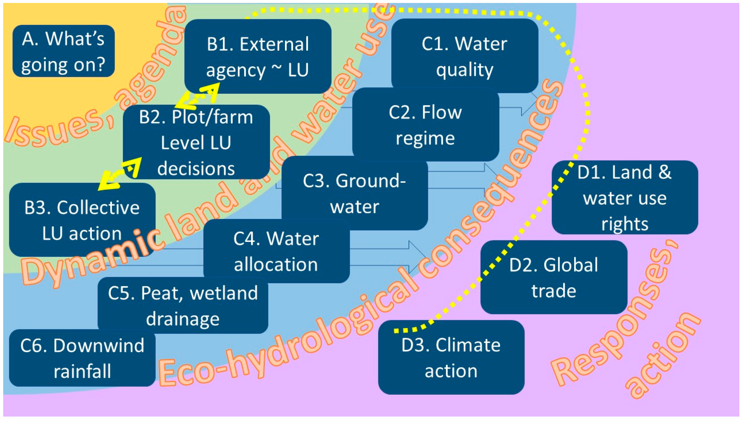
6. Action Orientation: Game Typology and Prototypes

The game development process is conventionally divided in four major steps: Step 1—Baseline study of the local landscape and context, diagnosing key issues, Step 2—Game development, Step 3—Game implementation, Step 4—Game impact assessment. In each of the SESAM landscapes, research will be strongly embedded in participatory action research and executed in close collaboration with (key)stakeholders. SESAM will facilitate and guide research in the four steps by providing a toolbox of relevant methods for each of the research steps. The toolbox will be filled with a collection of existing tools and methods as well as potentially newly developed methods. Inspiration will be taken from relevant well-established gaming communities, namely companion modelling network [59] and the International Simulation and Gaming Association [60].
In step 1, a thorough understanding of the complexity and context of the studied landscape will be developed by identifying and exploring the current social-ecological system. Proposed methods for this include stakeholder assessment [61], (P)ARDI [62], and fuzzy cognitive mapping [63]. Through these methods a conceptual understanding of the system will be developed. In addition, the Q methodology is recommended to identify the current perceptions of various stakeholder groups. In Step 2, the game will be developed based on the conceptual understanding of the systems developed in Step 1. Key actors, elements, of the system and their interactions will be represented in the game to allow for relevant dynamics and patterns to be reproduced. From the initial stakeholder assessment, stakeholders will be selected to be actively involved in the development and implementation of the game. Step 3 will be part of an initial learning loop with Step 2 in the target area, although it is common to pre-test games on other target audiences (e.g., students...). If games are re-used beyond their initial place of origin, Step 3 can follow directly from Step 1. Step 4, the impact of using serious games on (social) learning and stakeholder opinions will be assessed through qualitative, and semi-quantitative analysis. Some of the existing innovative methods, e.g., Q-method, to distinguish between concurrent discourses and ways of explaining observed phenomena [64,65] are currently being explored in the context of game impact (before vs. after) assessment. Existing natural resource management frameworks [29] are also relevant in this context as a way to assess stakeholder understanding, perception, and willingness to act and adopt improved management options.
Reflecting on the types of games that we may need to develop and test, we may need at least four types of games (Figure 10): A. games that share the discovery process of a diagnostic stage (Table 4), B. games that focus on land-use decisions (Table 5), C. games that add hydrological consequences (with their human impacts) to land-use decisions (Table 6), and D. games that also include responses, where stakeholders outside the landscape try to influence land-use decisions (Table 7).

7. Discussion: the Four Challenges to Use of Serious Games

Returning to the four issues restricting use of ‘serious games’ in the context of forest–water–people nexus issues, we need to take stock of how the SESAM program, in our current preview, will address the critique that games (1) are ad hoc with poorly defined extrapolation domains; (2) require heavy research investment from intervention experts; (3) have untested cultural limitations in where and how they can be used; and (4) lack clarity on where and how they can be used in policy making in local or global issue cycles. In doing so, we will need to return to the perspective of Figure 2, articulating it further in Figure 11. The figure shows (A) real-world social-ecological systems and their forest–water–people issues, (B) games as simplified representations of such systems, focused on specific aspects, and (C) use of these games in real-world contexts (potentially beyond where they were initially constructed). The match can be viewed from an ecological, a social or policy-oriented perspective.
SESAM intends to address the four game validity issues raised in the introduction as follows:

7.1. Providing a Scaffold for Scenario Evaluation Games in the Forest–Water–People Nexus

In order to address the current rather ad hoc nature of serious gaming studies in agroforestry, SESAM aims to develop a scaffold for scenario evaluation games in the forest–water–people nexus that could form an example in other fields in which games have been increasingly used. We will build up a library of games, describing games based on scope, content, format, track record (experiences) and identify games (e.g., as subtitle) by generic issue-in-context (e.g., tropical mountain lake). By creating this overview of games, starting from the games developed within SESAM, but not limited to the set of SESAM games, the program aims to be able to draw grounded conclusions on the interplay at the core of the forest–water–people nexus and the relevance and contribution of a serious gaming approach in this context. Through a cross-case study comparative analysis, we aim to identify how different interpretations of forest–water interaction influences the understanding, awareness and action related to landscape change and management at different levels of governance in different locations on a pantropical forest transition curve.
SESAM will perform a comparative analysis of all games developed and their impact on actor learning in different contexts. This will provide insights into larger methodological gaming-related questions contributing to the wider application of serious games as a generic approach for decision making under high levels of complexity and uncertainty. SESAM will match case-by-case games with other landscapes with (a) similar issue, (b) similar ecosystem and social characteristics, (c) same country or region, while starting from a ‘User demand’ point of view (‘what is the question?’ rather than ‘supply’ ‘we want to disseminate our research results’). The portfolio of games developed within the SESAM program should enable a more in depth understanding of (1) The relative value of different type of games, e.g., simple vs. complex, or fully defined vs. open, (2) game comfort zones linked to cultural context, age, gender and other social stratifiers, and, (3) learning effects (through before–after comparison) of game session participants who enter with different levels of knowledge. Classifying games and assessing the relative learning impact of gaming participants experienced will allow comparing learning from different game sessions with different games in distinct systems and contexts around the world. Based on this, recommendations will be developed to facilitate a wider use of well-documented games with track records.

7.2. Optimizing Research Investment in Game Development

Games currently rely on long-term, expensive prior research involvement. Optimizing research investment is key to support the broader use of serious games in participatory social-ecological systems research on the forest–water–people nexus and development of agroforested landscapes. SESAM will contribute towards optimizing research investments by (i) streamlining the serious gaming process from start to finish, and (ii) exploring options for the re-using games.
In order to streamline the serious gaming process, SESAM will develop guidelines for the development, implementation and analysis of games. These guidelines will consist of a standardized step-wise approach based on a number of complementary methods (see Section 6). By developing these SESAM guidelines and implementing them in our SESAM case studies, we aim to offer a streamlined game development process as well as to facilitate communication about games and between research teams in the serious gaming community. By doing so, SESAM aims to provide a scaffold to build upon existing knowledge and experience in the field of serious gaming in scenario evaluation and allow for research teams to connect and share experiences.
In addition, SESAM will address the question of transposability of games by exploring the use of games in contexts and settings beyond the original case study they have been developed in and assessing the impact of co-designed vs. off-the-shelf games. Some authors have already been successfully developing and exploring the implementation of games beyond their place or origin [66,67]. The development of such games that allow for more generic applications, requires the concepts used to be ‘valid’ and ‘robust’ in a wider range of circumstances, without claiming high accuracy in any specific location. Within SESAM we will cross-test games between case study areas within the comprehensive coverage of the forest–water–people nexus among the sites. SESAM will develop means of communication to assist in finding existing games and finding out whether they could be of use in a specific (new) situation. In addition, SESAM will describe how ‘long-term’ adaptability goals can be reconciled with ‘short-term’ match with data (e.g., by shifting from data-driven heuristics to first-principles models underlying the game).
SESAM will also develop Agent-Based Models (ABM) in parallel and interacting with game development, as this provides valuable insights in the adequacy of current process-level understanding of the social-ecological systems represented in the game [68,69].

7.3. Culture-Sensitive Gaming

Scenario games are artefacts that embody certain perceptions and values, but also allow various usages, e.g., through selection of player groups, setting of incentives, or usage of group discussions surrounding game rounds. The larger cultural setting influences these issues [52]. In SESAM we will have to create games that involve the future of agroforestry and the sustained livelihood of people. Based on existing national-level data on culture [51], there is a considerable ‘band-width’ for each of the six culture dimensions across the SESAM countries (Figure 9D), especially if the Netherlands is included as well. Within countries, there will undoubtedly be further variation, for example between the mountain and lowland forest people of Peru, the upriver and coastal zone people in Surinam and the islands (Sumatra, Kalimantan, Java) of Indonesia, within the SESAM portfolio.
The knowledge that unwritten rules of culture play a role implies that SESAM participants will be playing similar games across sites and looking for potential differences in game dynamics even if the pre-designed rules and incentives are identical. At design time, cultural differences between the designers and the intended users can cause blind spots [52]. We will be careful to design games that are meaningful and acceptable to participants. The local knowledge of our PhD candidates, as well as intensive contacts with stakeholders, should guarantee this. Dimensions of culture that we expect to be important for game design and dynamics are individualism and power distance—mentioned in one breath because they tend to be strongly correlated with tropical countries typically more hierarchical and collectivist than Western ones; and long-term orientation, which varies across countries in both the Tropics and the West. In conclusion, while a game is just an artefact and has no cultural awareness, its design and its usage can be done in culture-aware ways. SESAM intends to do this and document the results.

7.4. Game Relevance in the Policy Domain

One of the most confounding elements of policy issues is that there is a can of worms (and other parts of belowground biodiversity) of actors and interests, and nobody has an overview. This is precisely where games are strong: they provide a shared system boundary and show how actions of stakeholders impact the overall behavior of the system. In doing so, they also allow emotional responses to events, as well as joint (collective) action. In terms of system patterns, games allow to experience patterns such as the Tragedy of the Commons, or a Fix that Fails.
A review of 43 serious games and gamified applications related to water [70], covering a diversity of serious games, noted the still unsettled terminology in the research area of gamification and serious gaming and discussed how existing games could benefit early steps of decision making by problem structuring, stakeholder analysis, defining objectives, and exploring alternatives. Behavioral games on common pool resources may be used to facilitate self-governance [71], with groundwater a particularly challenging common pool resource to govern due to its low visibility, resulting in resource depletion in many areas. Serious games can promote values that transcend self-interest (transcendental values), based on the contributions of social psychology, but to do so, their design should incorporate the many value conflicts that are faced in real life water management and promote learning by having players reflect on the reasoning behind value priorities across water management situations [72,73].
This implies that potentially, not only playing games but also designing or adapting them can be very valuable for stakeholders in a policy-setting context [74]. A scenario game of one of the types in Figure 10 can be contextualized for and by local stakeholders; this exercise will generate relevant discussion and important learning. Being inclusive in which actors to select, as well as having support from important local persons, is essential [75]. Games also fit in a movement towards more plural and participatory approaches to ‘valuation’ of natural capital and ecosystem services [76].
All SESAM games will build on the boundary work tradition of taking the three ‘ways of knowing’ (local ecological knowledge, public/policy knowledge and science-based knowledge) as potentially complementing each other [32,77], with scope for new solutions to emerge at interfaces.
How can game use trigger policy change? From the five steps mentioned in Figure 3, it is relatively easy to see how games (including those of type 1) can be used for ‘Agenda setting’ and raising awareness of issues. Games are also a good vehicle for the ‘Better understanding’ part, as they offer insights not only into what happens, but how actor decisions contribute to outcomes of the game.
Hypothesis 1. 
The impact of serious games on ‘agenda setting’ and ‘better understanding’ parts of issue cycles is reflected in increased consensus about what is important to do and what changes can be expected to result from actions.
However, more is needed to nudge decisions locally and/or globally into desirable transformative and re-imaginative (game-changing) directions: commitment to aspirational goals.
Hypothesis 2. 
Embedding serious games in a stakeholder negotiation process, can contribute to commitment to aspirational goals for addressing underlying causes (‘drivers’), while addressing immediate symptoms.
Real progress depends, beyond ambitious policy language, on action [6]. Most ‘serious games’, however, will have limited precision and use an oversimplified problem description. Scenario analysis at ‘implementation’ level will often require more detailed spatial analysis of tradeoffs.
Hypothesis 3. 
Games are not a safe basis for operational decisions due to their limited specificity and (spatial) precision.
We expect that the SESAM studies will provide further evidence to judge the contexts in which ‘boundary work’ in the forest–water–people nexus can be supported through serious games to support game-changing transformations at ‘driver’ level.

8. Conclusions

Four challenges have been raised to the use of serious games in addressing issues such as those in the forest–water–people nexus: games so far (1) appear to be ad hoc, case dependent, with poorly defined extrapolation domains, (2) require heavy research investment, (3) have untested cultural limitations and (4) lack clarity on where and how they can be used in policy making. Reviewing the literature and considering a set of case study landscapes, we conclude that these challenges can be addressed at the design, testing and communication stages of games to be shared in a wider community.
The SESAM program of networked PhD research programs will be geared at credible, salient and legitimate action research designing, testing and using ‘serious games’, that are meant to (1) be systematic in their coverage of the pantropical forest–water–people nexus in its main manifestations and issues, using generic forest and tree cover transitions as continuum description rather than forest–agriculture dichotomies, supporting easy ‘localization’ of games to match local contexts, (2) use ‘basic hydrological, ecological, social and economic concepts, (3) be cognizant of the main dimensions in which cultural contexts of inter-human and human–nature relations vary to guide responsible game use, and (4) be explicitly adapted (or adaptable) to different stages of local and global issue cycles. The 13 landscapes provide a wide diversity of forest–water–people nexus aspects, as they range from low (<1 km−2) to very high (>1000 km−2) human population densities, high (>90%) to low (<5%) forest cover, five ecoclimatic zones (from drylands, sub-humid, via ‘water tower’ to humid and per-humid), and have focal issues that range from concerns over groundwater and streamflow depletion, flood-and-drought flow regimes, erosion and water quality to atmospheric moisture recycling, all (supposedly) influenced by quantity, quality and spatial pattern of tree cover (‘agroforestry’). Game prototypes are described for (1) a diagnostic phase where multiple explanations for identified local issues are explored, (2) a deeper understanding of individual and collective land-use decisions, (3) explicit consequences for a range of ecohydrological landscape functions of such decisions and (4) societal feedback to land users based on landscape-level consequences, through land and water use rights (‘planning’), global trade and climate action. Games are expected (hypothesized) to help in agenda setting phases, in achieving a common understanding of what is at stake and in political commitment to solutions—but will need more specific information to guide decisions on actual solutions. These hypotheses will be tested in the coming years.

Author Contributions

Conceptualization, M.v.N., E.S. and G.J.H.; Writing—original draft, M.v.N., E.S., G.J.H., A.F., A.Y.A., A.M., A.L.H., C.N.W., E.L., F.A., G.K., G.G.C.A., L.B., L.T., M.G., P.R., R.R.S. and U.S.; Writing—review and editing, S.A., A.L., P.v.O., C.M., M.P.-C., E.P., D.R., D.S. and A.J.T. All authors have read and agreed to the published version of the manuscript.

Funding

This research was funded by Wageningen University as one its INREF programs, with further support from twelve participating institutions.

Acknowledgments

The authors acknowledge assistance by Toha Zulkarnain for interpreting Forest Transition stages of the sites.

Conflicts of Interest

The authors declare no conflict of interest.

Appendix A. Brief Descriptions of the SESAM Landscapes

Appendix A.1. Upstream Remote Forests of the Suriname River Basin

Suriname, a country on the Guiana Shield in Latin America, is rich in rainforests and freshwater resources [78,79]. Its average annual rainfall in the area of 2700 mm [80] is an important source of evaporation that precipitates further inland in South America [41]. The Upper Suriname River Basin (USRB) is still mostly covered by primary and secondary forests [81]. The USRB is since several centuries inhabited by the Saamaka afro-descendent groups who, now around 20,000 people [82], live in 62 villages along the river. The Saamaka do not have legal land tenure rights, permanent electricity or running water, but live off ecosystem services provided by the forest (e.g., food, water, medicines, materials for housing and boats) [77]. The main income sources are rain-fed shifting cultivation and non-timber forest products, especially for the women. However, nature-based tourism has also become important. Some villages have community forest concessions, exploited by third parties. Competing interests and the community’s increasing participation in market economies lead to land-use conflicts and sustainability challenges. There is a clear need for better coordination and improved capacities to manage the USRB in a sustainable way, benefitting rights and stakeholders. Government decentralization was only partly successful as district governments have limited capacity and budget, and coordination between stakeholders remains poor. There have been recent improvements in forestry policies, but enforcement is a challenge. Forest, water and people in the USRB are inextricably linked, yet knowledge and understanding are lacking about these interactions and how different land uses affect them. Sustainably managing forests for their vital role in watersheds, precipitation sheds [83] and global climate is crucial, especially for vulnerable communities such as the Saamaka. Our study aims to improve shared understanding on the multi-scale effects of land-use changes on the forest–water–people nexus and apply gaming as a tool to enhance coordinated management of the landscape.

Appendix A.2. Upstream Forests of the Amazon in Madre de Dios, Peru

The Madre de Dios region, in the western part of the Amazon basin, is located in the south-eastern part of Peru and shares borders both with Brazil and Bolivia. The region is almost entirely covered (95%) by forest [84] and its mean annual precipitation is 2200 mm [85]. The region’s name originates from the Madre de Dios river that forms part of the vast Amazon River watershed [86]. The population of about 150,000 inhabitants is growing at a 2.6% yearly rate, partly due to immigration [87]. This migration originates mainly in the highlands and is driven by the economic perspectives offered to rural workers in the sectors of (illegal) gold mining and informal agriculture. Both these sectors have benefited of the recent pavement of the Inter-oceanic Highway, along which all recent deforestation hotspots are located [88]. In order to provide economic alternatives to mining, the regional government has started investing more resources in the agricultural sector. This strategy is mainly focused on cash crops, i.e., cacao (native to the Amazon) with a cultivated surface that has risen about 100% between 2010 and 2017 [87]. This agricultural intensification is likely to affect most smallholder farmers in the region and the high agrobiodiversity that is traditionally managed on their land. While small-scale farming remains little studied in the region, there is a growing need for transdisciplinary research that, by giving a voice to the farmers, allows them to become part of the conversation about land use. This case-study aims to provide a better understanding of smallholder farmer’s decision-making processes and how it is influenced by their systemic perception, i.e., the forest–water–people nexus. In the longer run, this will provide NGOs and the regional government with tools to better adapt their development programs to the local farmer’s needs and visions [89].

Appendix A.3. Mangrove Coasts of Suriname

The majority of the population of Suriname resides in the coastal area where also 90% of the economic activities is concentrated. The 370-km-long coastline harboring the largest and pristine mangrove forest of the Guianan Ecoregion serves the entire nation with its numerous ecosystem services. The Districts Nickerie and Paramaribo represent rural and urban parts of this coastal zone. The Suriname climate is tropical humid, with an average air humidity in the coastal area of 80-90% and a north-eastern (land inward) wind direction. Poor mangrove forest management and its ultimate destruction threaten the livelihoods of coastal communities, but also removes flood protection for the whole coastal zone. The root cause of the problem is lack of awareness about the mangrove ecosystem, its services and the effects of stakeholder activities on mangrove ecosystem services. Mangrove management can be achieved with the current legislation; however, the legislation is very much fragmented and sectoral in its orientation. In 2019, a national mangrove strategy has been developed for the ministry of Spatial Planning, Land and Forest Management. This study will apply serious games to increase awareness as well as to stimulate an effective decision-making process among stakeholders.

Appendix A.4. Amazonian Agroforestry Mosaics in Para State, Brazil

Pará State, which comprises a large portion of the Eastern Amazon basin in Brazil, has the highest level of deforestation of any subnational area in the tropical world [90] and is deemed a critical hotspot to contain the Amazon dieback [91] (breakdown of rainfall recycling). It thus has become a priority landscape for corporations to promote deforestation-free supply chains [92]. Nestled along the Acará river in the mesoregion of Northeastern Pará, the municipality of Tomé-Açu, has a population density of 10 km−2 and an area of roughly 5000 km2. It is currently dominated by oil palm, pastures and perennial crops, particularly cocoa, cupuaçu (Theobroma grandiflorum), black pepper, and açaí (Euterpe oleracea), a native palm, as well as slash and burn agriculture for cassava production, a mainstay of local livelihoods, and other annual crops [93]. Tomé Açu has seen 56% of its original forest cleared, mostly dating back to the 1970s and 1980s, whereas some neighboring municipalities still face high deforestation rates to this day. Since 2010, the municipality has been a hotspot of oil palm expansion against a backdrop of logging and extensive grazing juxtaposed by clusters of agroforestry innovation. Plummeting prices and fusarium disease that ravaged monocrop black pepper plantations in the 1960s and 1970s led Japanese settlers [94] to diversify their production systems to reduce such risks, developing what became known as the Tomé Açu Agroforestry Systems (SAFTAS) supported by a fruit-processing cooperative (CAMTA) [95]. These commercially oriented systems have become a key example widely followed by family farmers in Tomé Açu and far beyond in the Brazilian Amazon. This case study aims to shed light on the factors underlying agroecological intensification and agroforestry transition pathways in the Tomé Açu landscape, focusing on the constraints and levers for scaling agroforestry, with and without oil palm, and trade-offs between different agroforestry systems and other land-use options.

Appendix A.5. Tropical Peatland Restoration in Indonesia

Tropical peatlands form where drainage is limited, and organic matter decomposition cannot keep up with its production—often in lowland interfluvial locations. In the Ketapang Peatland in the coastal zone of West Kalimantan, (Indonesia) two Peatland Hydrological Unit (PHU): PHU Tolak river—Pawan river (948 km2) and PHU Pawan river—Pesaguan river (1048 km2) were selected to explore options for hydrological restoration. Human population density in these areas is low by Indonesian standards (20 people km−2 in 2017) and is dominated by people of Malay background, along with migrants from Java and Bali. Average annual rainfall is 3168 mm [96], but the June—October period is relatively dry in most years and, especially in El Niño years serious droughts develop. The area is dominated by logged-over peatland forest and oil palm plantations, with some rubber plantations and paddy rice fields. Expansion of plantations and agricultural areas has led to massive canal construction [97]. Besides their functions for log transport and human access, these canals also drain water from the peatlands so that oil-palm, rubber and crops can grow. As a result, however, the peatland becomes drier during the dry season and more vulnerable to forest fires, with haze directly affecting human health and well-being. Drainage can also cause saline seawater intrusion into the coastal zone. Peatland restoration aims to restore the hydrological function in the peatland area by increasing and stabilizing the groundwater levels in the peat dome, especially in the dry season, to reduce fire risk. Understanding the relationship between the environment and people is the key to build commitment among all stakeholders, so they can engage and cooperate to address the environmental issues. The objective of this study is to develop communication tools that can use to increase the level of understanding and to facilitate the communication process among stakeholders.

Appendix A.6. A Tropical Mountain Lake: Singkarak in Sumatra, Indonesia

Lake Singkarak is one of the highland lakes in the Bukit Barisan mountain range that runs the length of Sumatra. Inflow to the lake derives from an area of 1135 km2 through a number of streams and rivers, some with smaller natural lakes that provide some buffering. The watershed is home to 440,000 people with intensive horticulture in the upstream areas and extensive paddy cultivation before inflow to the lake. Located across two districts (Solok and Tanah Datar) the lake provides opportunities for fishing (an endemic fish, overfished due to high demand), year-round water supply for surrounding villages and tourism. The outflow of the lake provides irrigation water for downstream farmers and hydropower for West Sumatra Province. With annual rainfall ranging from 1700–3200 mm there is enough water for the hydropower plant in average years, but in years with long dry seasons there is a shortfall, as dropping the water level in the lake disturbs local livelihoods. The W side of the lake is dominated by forest, mixed gardens (agroforests) and agricultural fields, but the E Side is drier and dependent on the natural outflow from the lake that was disturbed by the construction in the 1990′s of the Singkarak Hydro Electric Power Plant [98]. There have been a number of reforestation project implemented in the area to increase amount of forest cover [99] and the local village surrounding the lake tried to protect the water quality and endemic fish by setting up their village regulation. Understanding the water allocation management (between water flows in the original riverbed flowing East), supporting traditional rice farmers, and the use for hydropower and irrigation schemes west of the mountain range [96]. The objective of this study to have a tool to support and enhance social learning and action by actors involved in multi-level decision-making processes around the nexus, and to explore how participatory decision-making on water and (agro)forest landscape management can be improved as part of climate change adaptation.

Appendix A.7. Water Tower for Adjacent Drylands: Mount Elgon, Uganda

Overlapping the international boundary between Uganda and Kenya, Mount Elgon is the 7th highest mountain in Africa rising to 4320 m a.s.l. It is approximately 100 km North-east of Lake Victoria. The mean annual rainfall is 1600 mm [100]. Forests in the Mt. Elgon ecosystem have become restricted to the protected upper slopes (23% forest cover in 2016). With 1000 people km−2 and a 3.4% annual increase the mid-slope is a densely populated agricultural landscape [101]. The region is a highly productive agricultural zone, growing arabica coffee and horticultural crops. The watershed contributes to Lake Victoria (and thus to its outflow, the Nile river), and lake Turkana) [102]. However, the ecosystem functionality and integrity has been compromised and impacted by climate change. The population increase has directly raised demand and competition for natural resources including land and water [103,104]. Due to land inheritance, land fragmentation is common and is expected to worsen with population increment mounting pressures on resources [105,106]. Besides, the declining land productivity has led to reduction in food produce thus deficit in food supplies to the continuously fast-growing human population. The resultant food gap has sparked encroachment into the national park and on riparian zones of riverbanks, swamps and steep slopes leading to soil erosion, siltation and flooding. There is overgrazing, destruction of forest for urban extension and high levels of conflict between the park authorities and locals. Landscape actors with divergent values/interests include resource users, local government, national conservation agencies, international donors and NGOs, local politicians, etc. To strengthen local natural resource governance, participatory scenario evaluation games for supporting and enhancing joint planning and social learning by actors involved in multi-level decision-making processes around the forest–water–people nexus will be developed and implemented.

Appendix A.8. Water Tower for Adjacent Drylands: the Ewaso Ng’iro River NW of Mount Kenya

Mount Kenya is located on the equator and rises to 5199 m a.s.l, 180 km north of Nairobi. The mountain has different zones of influence. The eastern climatic gradient is relatively humid (windward) and the western climatic gradient (leeward) stretches from humid (upstream) to semi-arid areas in the downstream. The mountain contributes about 50% of the entire flow of the Tana River, the largest river basin in Kenya providing water supply to 50% of the Kenyan population and 70% of the country’s hydroelectric power. Both rainfed and irrigated agriculture are major economic activities in the upstream. Further downstream many others rely on the river flows for irrigation, energy generation, pastoralism and hotels/tourism. Problems are related to over-abstraction of water [107], farm encroachment to fragile lands and deforestation [108]. Over-abstraction of river water in upper reaches and unwillingness to be held accountable through metering has been a major threat to meeting downstream flows. Different water management institutions exist, but activities are uncoordinated, leading to gaps in water resources management. The national government reacts by closing down water intakes in desperate attempts to resolve downstream water crises. Such orders affect schools, hospitals and thousands of households in the downstream. The local politicians strongly oppose the national government and defend the community water projects (most of them are unmetered). Consequently, an endless cycle of water crises characterizes the Mt. Kenya region [109]. Climate change and land-use changes continue to exert pressure on limited water resources. There is a need for increased knowledge and understanding among stakeholders for sustainable solutions. This study will explore the influence of climate change and land-use changes on downstream hydrology and apply serious games to explore decision making processes among stakeholders. This will provide a better understanding and knowledge for sustainable development.

Appendix A.9. Mountain Farming in the Andes, Peru

The Peruvian region of Puno is located in the south-eastern Peru on the shore of Lake Titicaca close to the border with Bolivia. The region is poorly covered (0.1%) by forest [84] and the mean annual rainfall averages 700 mm [110]. The watershed of Lake Titicaca extends for 8490 km2. The highlands—over 3000 m high—region of Lake Titicaca supports a population density of 5.1 km−2 [87]. In the region of Puno of the Altiplano, in Peru, farmers with their knowledge and practices are growing the highest quinoa diversity hotspot in the world [111]. The potential of quinoa was promoted by the United Nations during the International Year of Quinoa (IYQ) in 2013 [112]. However, IYQ-2013 did not cover aspects of the worldwide spread of and commercial interests in quinoa, and the unbalanced competition between producers from the Andes and producers from North America and Europe [113]. Collective governance instruments as collective trademark (CT) are used to defend property rights on trading products and to recognize their anteriority and origin. Co-developing an Andean quinoa CT rise our research objective: explore the process of co-constructing a CT for recognize and promote quinoa in the global market. The region of Puno in Peru (the highest quinoa diversity hotspot in the world) is selected as case study. Participatory games and agent-based models will be developed and explored to assess the gap between local and regional farmers, and higher level including Andean quinoa farmers for developing an Andean CT for quinoa. The proposed research will explore the role CT can play to preserve the Andean generic hotspot of quinoa as well as to provide a potentially relevant governance tool for other neglected crops that suddenly get global consumer attention.

Appendix A.10. Farming Drylands on the Mossi Plateau, Burkina Faso

The Mossi Plateau in the central part of Burkina-Faso in West-Africa spans the Sudano–Sahelian climate gradient, with unimodal rainfall from June to September, with an annual average ranging from 400-700 mm [114]. Two villages (Yilou and Tansin) represent this gradient, with sandy clay loam soils, low in soil organic carbon (0.2 and 0.4, respectively) [115]. Agriculture in this area is challenged by low and unstable biomass production, limiting farmers’ resilience. Water, nutrients, biomass, labor, information and money move in the landscape, while many studies focused on biomass production at farm scale only considering single households [116,117,118], without their interactions. Biomass management through farmers’ decisions on biomass allocation [119], include use of crop residues as livestock feed [120], indirectly influencing manure availability for crop production. At village scale, biomass production is determined by farmers’ organization, the spatial and temporal interactions amongst farmers, and between farmers and their biophysical environment (soil fertility), as farmers can organize themselves in “labor-groups” to till each other’s fields and thus be able to cultivate more land. As rainfall tends to vary spatially, risk management depends on the collective use of space. A spatio-temporal modelling approach [121,122] needs to take the various spatial and social interactions into account. We aim to achieve this by co-designing tailored and realistic biomass management and organization options to improve farmers’ production and livelihoods through participatory modelling.

Appendix A.11. Upland Agroforestry Mosaics in Kali Konto, East Java, Indonesia

The Kali Konto sub-watershed in East Java contributes to the Brantas river, and covers an area of approximately 240 km2 with elevation ranging from 600-2800 m a.s.l. The Kali Konto river is approximately 40 km long and empties into Selorejo reservoir. The average daily temperature is 20–22 °C with a mean annual rainfall ranging from 2995–4422 mm [123]. Forest area has significantly decreased in the last two decades (from 30.5% of forest cover in 1990 to 20.4% in 2005), following the increased demand for timber, firewood, fodder and other agriculture (and dairy) products [124,125]. On the other hand, annual crops area increased by 26%. In the last three decades, the population increased by approximately 20% from 1990 adding more pressure to the system [126]. Intensive agricultural farming with minimum tree cover in hill slope leads to the increase of soil surface exposure, which is followed by higher soil erosion and sedimentation (top ‘fertile’ soil washed away) to the river [127] and impacts on crop production [128]. The polluted reservoir brings negative consequences for both the state water management corporation that is responsible for managing water quality and quantity in the region and downstream ‘water’ beneficiary (HIPAM–drinking water user association) [129]. Efforts have been made by PJT to encourage soil conservation practices. However, it has not yet accommodated farmers’ choice on the type of land management in the program. It is essential to understand farmers’ preferences and decision making along with the direct consequences for livelihoods and environmental impact. It benefits on exploring environmentally friendly management options based on their preference and increase the awareness on the importance of achieving sustainable watershed conservation through collaborative action among stakeholders.

Appendix A.12. Water Tower for a Metropole: Rejoso, East Java, Indonesia

The Rejoso watershed stretches from the Mount Bromo volcano crater (summit at 2329 m a.s.l.) to the Pasuruan coastal area (0 m a.s.l.) covering an area of 62,773 ha. Land in the watershed is used in a variety of ways: a national park (conservation forests), protected forests (natural jungle forests), monoculture production forests, agroforestry (production forest + agricultural + livestock), irrigated lowland agriculture and built-up areas. The watershed covers 14 sub-districts in Pasuruan Regency and three sub-districts in Pasuruan City with a total population in 2018 of 838,313 people [130,131], with 100,497 people living in the upstream part, 271,908 in the middle zone and 465,728 in the downstream area. Most of the population, except residents of Pasuruan City, depend for their livelihoods on their agricultural and agroforestry systems, supported by the ecosystem services provided by land and water resources, including ecotourism [132,133,134]. They worked collaboratively (but there are conflicts as well) with multi-stakeholder institutions in charge of managing natural resources. Since 2003, for example, residents in all parts who are members of the forest village community (LMDH) collaborate with Perhutani (a state-owned forestry company) in ‘the Community Joint Forest Management Program (PHBM). They are allowed to plant (intercropping) various agricultural commodities (horticulture, food crops, and fruit trees) and fodder in between the stands of production forest trees. They also get wages and/or profit-sharing after contributing to maintaining the main trees (teak, pine, mahogany, eucalyptus) which are managed together with Perhutani. There are at least 114 village communities that use the Perhutani area of 11,713 ha [135]. Before the PHBM was implemented, conflicts often occurred between communities and Perhutani. In the upstream part, communities collaborate with national park managers (Ministry of Environment and Forestry (MoEF)), natural resource conservation offices (MoEF), and tourism agencies authorities. Another collaboration is ‘the Rejoso-Kita Program’ which implements an integrated watershed management model. Hydrological analysis suggests that the tree cover required for ‘infiltration friendly’ land uses depends on the altitudinal zone [136]. The program involved various stakeholders: communities, NGOs, private sectors, and multi-level governments [137,138,139]. Although, there have been collaborations, conflicts have also been reported, including communities and the private sector (mining industry in the middle and water industry in the downstream). The study to be carried out at this location aims to design participatory collective action games to strengthen sustainability community–private–government collaboration in agroforestry management.

Appendix A.13. Rehabilitating a Water Tower Under Pressure: Brantas, East Java, Indonesia

The Upper Brantas sub watershed is the source area of the Brantas river that starts from the southwestern mountainous slope of active volcanoes of the Arjuna-Anjasmara mountain complex (a protected forest area). Originating at the Sumberbrantas spring, the river flows southward through the cities of Batu and Malang, before bending to the West and then North to the Provincial capital Surabaya. Total area of the sub watershed is 180 km2. Annual rainfall ranges from 875 to 3000 mm [140]. Its forest fraction is 23.8%. The Upper Brantas sub-watershed population size in 2018 was 207,490, with a density 1092 km−2 and an annual population growth of 0.95 per year [141]. Forest encroachment was a serious environmental problem in the 1998–2000 era. Conflicts over state forest land became visible in 1998 during the political reformation, when many local farmers occupied state forest land [142]. In this period power was decentralized to provincial and district levels. This period meant the end of timber forest management. Over 2003–2007, the settlement area increased by 9%, plantation and farms increased by 7%, and the forest area decreased by 6%. The watershed response can be observed through the increasing of run-off coefficient from 0.59 to 0.67 [143] and an increase in peak discharge (at the outflow of the sub-watershed) from 96.8 m3 s−1 in 2003 to 189.2 m3 s−1 in 2007 [144]. Meanwhile the springs were affected (data to be further collected) and groundwater recharge was probably reduced. Policy level response to the forest encroachment was a number of new programs. In 2001 the state forest agency introduced a co-management program, specially focused on forest resource management. In 2007 the co-management concept became relabeled as community-based forest management. The objective of the case study is to develop games and simulations of land-use change of recharge area management for sustainable groundwater supply and demand. There are many volcanic slope watersheds in Indonesia similar to the upper Brantas sub-watershed.

References

  1. van Noordwijk, M.; Coe, R.; Sinclair, F.L. Agroforestry paradigms. In Sustainable Development through Trees on Farms: Agroforestry in its Fifth Decade; van Noordwijk, M., Ed.; World Agroforestry (ICRAF): Bogor, Indonesia, 2019; pp. 1–12. Available online: http://www.worldagroforestry.org/trees-on-farms (accessed on 20 July 2020).
  2. Sustainable Developent Goals. Available online: https://sustainabledevelopment.un.org/sdgs (accessed on 21 June 2020).
  3. Taleb, N.N.; Douady, R. Mathematical definition, mapping, and detection of (anti) fragility. Quant. Financ. 2013, 13, 1677–1689. [Google Scholar] [CrossRef] [Green Version]
  4. Meadows, D. Leverage Points: Places to Intervene in a System. 1999. Available online: http://donellameadows.org/archives/leverage-points-places-to-intervene-in-a-system/ (accessed on 21 June 2020).
  5. Minang, P.A.; van Noordwijk, M.; Freeman, O.E.; Mbow, C.; de Leeuw, J.; Catacutan, D. (Eds.) Climate-Smart Landscapes: Multifunctionality in Practice; World Agroforestry Centre (ICRAF): Nairobi, Kenya, 2015; p. 405. [Google Scholar]
  6. Climate-Smart Landscapes: Multifunctionality in Practice. Available online: http://www.worldagroforestry.org/publication/climate-smart-landscapes-multifunctionality-practice (accessed on 20 July 2020).
  7. van Noordwijk, M.; Lusiana, B.; Villamor, G.B.; Purnomo, H.; Dewi, S. Feedback loops added to four conceptual models linking land change with driving forces and actors. Ecol. Soc. 2011, 16. Available online: http://www.ecologyandsociety.org/vol16/iss1/resp1/ (accessed on 20 July 2020). [CrossRef]
  8. van Noordwijk, M. Prophets, Profits, Prove It: Social Forestry under Pressure. One Earth 2020, 2, 394–397. [Google Scholar] [CrossRef]
  9. Creed, I.F.; van Noordwijk, M. Forest and Water on a Changing Planet: Vulnerability, Adaptation and Governance Opportunities: A Global Assessment Report (No. 38); International Union of Forest Research Organizations (IUFRO): Vienna, Austria, 2018; p. 188. Available online: https://www.iufro.org/fileadmin/material/publications/iufro-series/ws38/ws38.pdf (accessed on 20 July 2020).
  10. Creed, I.F.; Jones, J.A.; Archer, E.; Claassen, M.; Ellison, D.; McNulty, S.G.; van Noordwijk, M.; Vira, B.; Wei, X.; Bishop, K.; et al. Managing Forests for both Downstream and Downwind Water. Front. For. Glob. Chang. 2019. [Google Scholar] [CrossRef] [Green Version]
  11. Nobre, C.A. Land-use and climate change risks in the Amazon and the need of a novel sustainable development paradigm. Proc. Natl. Acad. Sci. USA 2016, 113, 10759–10768. [Google Scholar] [CrossRef] [PubMed] [Green Version]
  12. Page, S.E. The Difference: How the Power of Diversity Creates Better Groups, Firms, Schools, and Societies (New Edition); Princeton University Press: Princeton, NJ, USA, 2008; p. 448. [Google Scholar]
  13. Walker, B. Resilience management in social-ecological systems: A working hypothesis for a participatory approach. Conserv. Ecol. 2002, 6, 14. Available online: http://www.consecol.org/vol6/iss1/art14 (accessed on 20 July 2020). [CrossRef]
  14. Reed, M.S. Stakeholder participation for environmental management: A literature review. Biol. Conserv. 2008, 141, 2417–2431. [Google Scholar] [CrossRef]
  15. Scholz, G. An Analytical Framework of Social Learning Facilitated by Participatory Methods. Syst. Prac. Action Res. 2013, 27, 575–591. [Google Scholar] [CrossRef]
  16. Angelstam, P.; Andersson, K.; Annerstedt, M.; Axelsson, R.; Elbakidze, M.; Garrido, P.; Grahn, P.; Jönsson, K.I.; Pedersen, S.; Schlyter, P.; et al. Solving problems in social–ecological systems: Definition, practice and barriers of transdisciplinary research. Ambio 2013, 42, 254–265. [Google Scholar] [CrossRef] [Green Version]
  17. Tschakert, P. Anticipatory Learning for Climate Change Adaptation and Resilience. Ecol. Soc. 2010, 15, 11. Available online: http://www.ecologyandsociety.org/vol15/iss2/art11 (accessed on 20 July 2020). [CrossRef]
  18. Rodela, R.; Ligtenberg, A.; Bosma, R. Conceptualizing Serious Games as a learning-Based Intervention in the Context of Natural Resources and Environmental Governance. Water 2019, 11, 245. [Google Scholar] [CrossRef] [Green Version]
  19. García-Barrios, L.E.; Speelman, E.N.; Pim, M. An educational simulation tool for negotiating sustainable natural resource management strategies among stakeholders with conflicting interests. Ecol. Model. 2008, 210, 115–126. [Google Scholar] [CrossRef]
  20. Villamor, G.B.; van Noordwijk, M. Social role-play games vs individual perceptions of conservation and PES agreements for maintaining rubber agroforests in Jambi (Sumatra), Indonesia. Ecol. Soc. 2011, 16, 27. [Google Scholar] [CrossRef]
  21. Speelman, E.N.; García-Barrios, L.E.; Groot, J.C.J.; Tittonell, P. Gaming for smallholder participation in the design of more sustainable agricultural landscapes. Agric. Syst. 2014, 126, 62–75. [Google Scholar] [CrossRef]
  22. Speelman, E.N.; van Noordwijk, M.; Garcia, C. Gaming to better manage complex natural resource landscapes. In Co-investment in Ecosystem Services: Global Lessons from Payment and Incentive Schemes; Namirembe, S., Leimona, B., van Noordwijk, M., Minang, P., Eds.; World Agroforestry Centre (ICRAF): Nairobi, Kenya, 2017; pp. 480–489. [Google Scholar]
  23. García-Barrios, L.; Cruz-Morales, J.; Vandermeer, J.; Perfecto, I. The Azteca Chess experience: Learning how to share concepts of ecological complexity with small coffee farmers. Ecol. Soc. 2017, 22. [Google Scholar] [CrossRef] [Green Version]
  24. Mayer, I.; Bekebrede, G.; Harteveld, C.; Warmelink, H.; Zhou, Q.; Van Ruijven, T.; Lo, J.; Kortmann, R.; Wenzler, I. The research and evaluation of serious games: Toward a comprehensive methodology. Br. J. Educ. Technol. 2014, 45, 502–527. [Google Scholar] [CrossRef]
  25. Hofstede, G.J. One game does not fit all cultures. In Organizing and Leaning through Gaming and Simulation, Proceedings of ISAGA, Nijmegen, The Netherlands, 9–13 July 2007; Mayer, I., Mastik, H., Eds.; Eburon Uitgeverij BV: Nijmegen, The Netherlands, 2007; pp. 103–110. [Google Scholar]
  26. Jann, W.; Wegrich, K. Theories of the policy cycle. In Handbook of Public Policy Analysis: Theory, Politics, and Methods; CRC Press: Boca Raton, FL, USA, 2007; Volume 125, pp. 43–62. [Google Scholar]
  27. Clark, W.C.; Tomich, T.P.; van Noordwijk, M.; Guston, D.; Catacutan, D.; Dickson, N.M.; McNie, E. Boundary work for sustainable development: Natural resource management at the Consultative Group on International Agricultural Research (CGIAR). Proc. Natl. Acad. Sci. USA 2016, 113, 4615–4622. [Google Scholar] [CrossRef] [Green Version]
  28. Kristensen, P. The DPSIR framework. In Workshop on a Comprehensive/Detailed Assessment of the Vulnerability of Water Resources to Environmental Change in Africa Using River Basin Approach; UNEP Headquarters: Nairobi, Kenya, 2004; p. 10. Available online: http://enviro.lclark.edu:8002/rid%3D1145949501662_742777852_522/DPSIR%20 Overview.pdf (accessed on 20 July 2020).
  29. Svarstad, H.; Petersen, L.K.; Rothman, D.; Siepel, H.; Wätzold, F. Discursive biases of the environmental research framework DPSIR. Land Use Policy 2008, 25, 116–125. [Google Scholar] [CrossRef]
  30. Diaz, S.; Settele, J.; Brondízio, E.; Ngo, H.; Guèze, M.; Agard, J.; Arneth, A.; Balvanera, P.; Brauman, K.; Butchart, S.; et al. Summary for Policymakers of the Global Assessment Report on Biodiversity and Ecosystem Services of the Intergovernmental Science-Policy Platform on Biodiversity and Ecosystem Services; IPBES: Bonn, Germany, 2020; p. 56. [Google Scholar]
  31. van Noordwijk, M. Integrated natural resource management as pathway to poverty reduction: Innovating practices, institutions and policies. Agric. Syst. 2019, 172, 60–71. [Google Scholar] [CrossRef]
  32. Mithöfer, D.; van Noordwijk, M.; Leimona, B.; Cerutti, P.O. Certify and shift blame, or resolve issues? Environmentally and socially responsible global trade and production of timber and tree crops. Int. J. Biodivers. Sci. Ecosyst. Serv. Manag. 2017, 13, 72–85. [Google Scholar] [CrossRef] [Green Version]
  33. Hofstede, G.J. GRASP agents: Social first, intelligent later. Ai Soc. 2019, 34, 535–543. [Google Scholar] [CrossRef] [Green Version]
  34. van Noordwijk, M.; Dewi, S.; Leimona, B.; Lusiana, B.; Wulandari, D. Negotiation-Support Toolkit for Learning Landscapes; World Agroforestry Centre: Bogor, Indonesia, 2013; p. 285. Available online: http://www.worldagroforestry.org/publication/negotiation-support-toolkit-learning-landscapes (accessed on 20 July 2020).
  35. van Noordwijk, M.; Leimona, B.; Jindal, R.; Villamor, G.B.; Vardhan, M.; Namirembe, S.; Catacutan, D.; Kerr, J.; Minang, P.A.; Tomich, T.P. Payments for Environmental Services: Evolution towards efficient and fair incentives for multifunctional landscapes. Annu. Rev. Environ. Resour. 2012, 37, 389–420. [Google Scholar] [CrossRef]
  36. Shyamsundar, P.; Ahlroth, S.; Kristjanson, P.; Onder, S. Supporting pathways to prosperity in forest landscapes–A PRIME framework. World Dev. 2020, 125, 104622. [Google Scholar] [CrossRef]
  37. Dewi, S.; van Noordwijk, M.; Zulkarnain, M.T.; Dwiputra, A.; Hyman, G.; Prabhu, R.; Gitz, V.; Nasi, R. Tropical forest-transition landscapes: A portfolio for studying people, tree crops and agro-ecological change in context. Int. J. Biodivers. Sci. Ecosyst. Serv. Manag. 2017, 13, 312–329. [Google Scholar] [CrossRef]
  38. van Noordwijk, M.; Bruijnzeel, S.; Ellison, D.; Sheil, D.; Morris, C.E.; Sands, D.; Gutierrez, V.; Cohen, J.; Sullivan, C.A.; Verbist, B.; et al. Ecological rainfall infrastructure: Investment in trees for sustainable development. In ASB Policy Brief 47; World Agroforestry Centre: Nairobi, Kenya, 2015; p. 6. Available online: http://www.asb.cgiar.org/Publications%202015/PBs/ASB_PB47.p (accessed on 20 July 2020).
  39. Ellison, D.; Morris, C.E.; Locatelli, B.; Sheil, D.; Cohen, J.; Murdiyarso, D.; Gutierrez, V.; van Noordwijk, M.; Creed, I.F.; Pokorny, J.; et al. Trees, forests and water: Cool insights for a hot world. Glob. Environ. Chang. 2017, 43, 51–61. [Google Scholar] [CrossRef]
  40. van Noordwijk, M.; Creed, I.F.; Jones, J.A.; Wei, X.; Gush, M.; Blanco, J.A.; Sullivan, C.A.; Bishop, K.; Murdiyarso, D.; Xu, J.; et al. Climate-forest-water-people relations: Seven system delineations. In Forest and Water on a Changing Planet: Vulnerability, Adaptation and Governance Opportunities: A Global Assessment Report (No. 38); International Union of Forest Research Organizations (IUFRO): Vienna, Austria, 2018; pp. 27–58. [Google Scholar]
  41. van Noordwijk, M.; Tanika, L.; Lusiana, B. Flood risk reduction and flow buffering as ecosystem services: I. Theory on a flow persistence indicator. Hydrol. Earth Syst. Sci. 2017, 21, 2321–2340. [Google Scholar] [CrossRef] [Green Version]
  42. van Noordwijk, M.; Tanika, L.; Lusiana, B. Flood risk reduction and flow buffering as ecosystem services II. Land use and rainfall intensity effects in Southeast Asia. Hydrol. Earth Syst. Sci. 2017, 21, 2341–2352. [Google Scholar] [CrossRef] [Green Version]
  43. van der Ent, R.J.; Savenije, H.H.G.; Schaefli, B.; Steele-Dunne, S.C. Origin and fate of atmospheric moisture over continents. Water Resour. Res. 2010, 46, W09525. [Google Scholar] [CrossRef] [Green Version]
  44. Ellison, D.; Wang-Erlandsson, L.; van der Ent, R.; van Noordwijk, M. Upwind forests: Managing moisture recycling for nature-based resilience. Unasylva 2019, 251, 14–26. [Google Scholar]
  45. Teuling, A.J.; Taylor, C.M.; Meirink, J.F.; Melsen, L.A.; Miralles, D.G.; Van Heerwaarden, C.C.; Vautard, R.; Stegehuis, A.I.; Nabuurs, G.J.; de Arellano, J.V.G. Observational evidence for cloud cover enhancement over western European forests. Nat. Commun. 2017, 8, 14065. [Google Scholar] [CrossRef] [Green Version]
  46. Tuinenburg, O.A.; Staal, A. Tracking the global flows of atmospheric moisture and associated uncertainties. Hydrol. Earth Syst. Sci. 2020, 24, 2419–2435. Available online: https://www.hydrol-earth-syst-sci.net/24/2419/2020/ (accessed on 17 July 2020). [CrossRef]
  47. van Noordwijk, M.; Bargues-Tobella, A.; Muthuri, C.W.; Gebrekirstos, A.; Maimbo, M.; Leimona, B.; Bayala, J.; Ma, X.; Lasco, R.; Xu, J.; et al. Agroforestry as part of nature-based water management. In Sustainable Development through Trees on Farms: Agroforestry in its Fifth Decade; van Noordwijk, M., Ed.; World Agroforestry (ICRAF): Bogor, Indonesia, 2019; pp. 261–287. [Google Scholar]
  48. Guswa, A.J.; Tetzlaff, D.; Selker, J.S.; Carlyle-Moses, D.E.; Boyer, E.W.; Bruen, M.; Cayuela, C.; Creed, I.F.; van de Giesen, N.; Grasso, D.; et al. Advancing ecohydrology in the 21st century: A convergence of opportunities. Ecohydrology 2020, e2208. [Google Scholar] [CrossRef] [Green Version]
  49. Kadykalo, A.N.; López-Rodriguez, M.D.; Ainscough, J.; Droste, N.; Ryu, H.; Ávila-Flores, G.; Le Clec’h, S. Disentangling ‘ecosystem services’ and ‘nature’s contributions to people’. Ecosyst. People 2019, 15, 269–287. [Google Scholar] [CrossRef] [Green Version]
  50. van Noordwijk, M. Did Mother Nature consent in the human ‘appropriation’ of ‘gifts’ so sweet, or would a #MeToo hashtag get flooded if she could tweet? Sci. E-Lett. 2019, 359, 270. [Google Scholar]
  51. Beugelsdijk, S.; Welzel, C. Dimensions and dynamics of national culture: Synthesizing Hofstede with Inglehart. J. Cross-Cult. Psychol. 2018, 49, 1469–1505. [Google Scholar] [CrossRef] [PubMed]
  52. Minkov, M. A revision of Hofstede’s model of national culture: Old evidence and new data from 56 countries. Cross Cult. Strateg. Manag. 2018, 25, 231–256. [Google Scholar] [CrossRef] [Green Version]
  53. Dimension Data Matrix. Available online: https://geerthofstede.com/research-and-vsm/dimension-data-matrix/ (accessed on 20 July 2020).
  54. Hofstede, G.; Hofstede, G.J.; Minkov, M. Cultures and Organizations: Software of the Mind, 3rd ed.; McGraw-Hill: New York, NY, USA, 2010; p. 561. [Google Scholar]
  55. Hofstede, G.J. Culture’s causes: The next challenge (Distinguished scholar essay). Cross Cult. Manag. 2015, 22, 545–569. [Google Scholar] [CrossRef]
  56. Hofstede, G.J.; Murff, E.J. Repurposing an Old Game for an International World. Simul. Gaming 2012, 43, 34–50. [Google Scholar] [CrossRef] [Green Version]
  57. Hofstede, G.J.; de Caluwé, L.; Peters, V. Why Simulation Games Work-In Search of the Active Substance: A Synthesis. Simul. Gaming 2010, 41, 824–843. [Google Scholar] [CrossRef]
  58. Villamor, G.B.; Badmos, B.K. Grazing game: A learning tool for adaptive management in response to climate variability in semiarid areas of Ghana. Ecol. Soc. 2016, 21. [Google Scholar] [CrossRef] [Green Version]
  59. Barreteau, O. Our companion modelling approach. J. Artif. Soc. Soc. Simul. 2003, 6, 1. Available online: http://jasss.soc.surrey.ac.uk/6/2/1.html (accessed on 20 July 2020).
  60. International Simulation and Gaming Association. Available online: https://www.isaga.com/ (accessed on 20 July 2020).
  61. Reed, M.S.; Graves, A.; Dandy, N.; Posthumus, H.; Hubacek, K.; Morris, J.; Prell, C.; Quinn, C.H.; Stringer, L.C. Who’s in and why? A typology of stakeholder analysis methods for natural resource management. J. Environ. Manag. 2009, 90, 1933–1949. [Google Scholar] [CrossRef] [PubMed]
  62. Etienne, M.; Du Toit, D.R.; Pollard, S. ARDI: A co-construction method for participatory modeling in natural resources management. Ecol. Soc. 2011, 16. Available online: http://www.ecologyandsociety.org/vol16/iss1/art44/ (accessed on 20 July 2020). [CrossRef] [Green Version]
  63. Vanwindekens, F.M.; Baret, P.V.; Stilmant, D. A new approach for comparing and categorizing farmers’ systems of practice based on cognitive mapping and graph theory indicators. Ecol. Model. 2014, 274, 1–11. [Google Scholar] [CrossRef]
  64. Langston, J.; McIntyre, R.; Falconer, K.; Sunderland, T.; Van Noordwijk, M.; Boedhihartono, A.K. Discourses mapped by Q-method show governance constraints motivate landscape approaches in Indonesia. PLoS ONE 2019, 14, e0211221. [Google Scholar] [CrossRef] [PubMed]
  65. Amaruzaman, S.; Leimona, B.; van Noordwijk, M.; Lusiana, B. Discourses on the performance gap of agriculture in a green economy: A Q-methodology study in Indonesia. Int. J. Biodivers. Sci. Ecosyst. Serv. Manag. 2017, 13, 233–247. [Google Scholar] [CrossRef]
  66. Page, C.L.; Dray, A.; Perez, P.; Garcia, C. Exploring how knowledge and communication influence natural resources management with ReHab. Simul. Gaming 2016, 47, 257–284. [Google Scholar] [CrossRef]
  67. Andreotti, F.; Speelman, E.N.; Van den Meersche, K.; Allinne, C. Combining participatory games and backcasting to support collective scenario evaluation: An action research approach for sustainable agroforestry landscape management. Sustain. Sci. 2020. [Google Scholar] [CrossRef]
  68. Ligtenberg, A.; van Lammeren, R.J.A.; Bregt, A.K.; Beulens, A.J.M. Validation of an agent-based model for spatial planning: A role-playing approach. Comput. Environ. Urban Syst. 2010, 34, 424–434. [Google Scholar] [CrossRef]
  69. Van Oel, P.R.; Mulatu, D.W.; Odongo, V.O.; Willy, D.K.; Van der Veen, A. Using data on social influence and collective action for parameterizing a geographically-explicit agent-based model for the diffusion of soil conservation efforts. Environ. Model. Assess. 2019, 24, 1–19. [Google Scholar] [CrossRef] [Green Version]
  70. Aubert, A.H.; Bauer, R.; Lienert, J. A review of water-related serious games to specify use in environmental Multi-Criteria Decision Analysis. Environ. Model. Softw. 2018, 105, 64–78. [Google Scholar] [CrossRef]
  71. Meinzen-Dick, R.; Janssen, M.A.; Kandikuppa, S.; Chaturvedi, R.; Rao, K.; Theis, S. Playing games to save water: Collective action games for groundwater management in Andhra Pradesh, India. World Dev. 2018, 107, 40–53. [Google Scholar] [CrossRef]
  72. Marini, D.; Medema, W.; Adamowski, J.; Veissière, S.P.; Mayer, I.; Wals, A.E. Socio-psychological perspectives on the potential for serious games to promote transcendental values in IWRM decision-making. Water 2018, 10, 1097. [Google Scholar] [CrossRef] [Green Version]
  73. Buyinza, J.; Nuberg, I.K.; Muthuri, C.W.; Denton, M.D. Psychological Factors Influencing Farmers’ Intention to Adopt Agroforestry: A Structural Equation Modeling Approach. J. Sustain. For. 2020. [Google Scholar] [CrossRef]
  74. Guyot, P.; Honiden, S. Agent-based participatory simulations: Merging multi-agent systems and role-playing games. J. Artif. Soc. Soc. Simul. 2006, 9, 8. Available online: http://jasss.soc.surrey.ac.uk/9/4/8.html (accessed on 20 July 2020).
  75. Speelman, E.N.; Rodela, R.; Doddema, M.; Ligtenberg, A. Serious gaming as a tool to facilitate inclusive business; a review of untapped potential. Curr. Opin. Environ. Sustain. 2019, 41, 31–37. [Google Scholar] [CrossRef]
  76. Zafra-Calvo, N.; Balvanera, P.; Pascual, U.; Merçon, J.; Martin-Lopez, B.; van Noordwijk, M.; Heita Mwampamba, T.; Lele, S.; Ifejika Speranza, C.; Arias-Arévalok, P.; et al. Plural valuation of nature for equity and sustainability: Insights from the Global South. Glob. Environ. Chang. 2020, 63, 102115. [Google Scholar] [CrossRef]
  77. Leimona, B.; Lusiana, B.; van Noordwijk, M.; Mulyoutami, E.; Ekadinata, A.; Amaruzaman, S. Boundary work: Knowledge co-production for negotiating payment for watershed services in Indonesia. Ecosyst. Serv. 2015, 15, 45–62. [Google Scholar] [CrossRef] [Green Version]
  78. Ouboter, P.E. (Ed.) The Fresh Water Ecosystems of Suriname; Kluwer Academic Publishers: Dordrecht, The Netherlands, 1993; p. 315. [Google Scholar]
  79. Misiedjan, D.J.E. Towards a Sustainable Human Right to Water: Supporting Vulnerable People and Protecting Water Resources with Suriname as a Case Study. Ph.D. Thesis, Utrecht University, Utrecht, The Netherlands, 2017; p. 220. [Google Scholar]
  80. Nurmohamed, R.; Naipal, S.; Becker, C. Changes and variation in the discharge regime of the Upper Suriname River Basin and its relationship with the tropical Pacific and Atlantic SST anomalies. Hydrol. Process. 2008, 22, 1650–1659. [Google Scholar] [CrossRef]
  81. Ramirez, S.O.I.; Verweij, P.; Best, L.; van Kanten, R.; Rambaldi, G.; Zagt, R. P3DM as a socially engaging and user-useful approach in ecosystem service assessment among marginalized communities. Appl. Geogr. 2017, 83, 63–77. [Google Scholar] [CrossRef] [Green Version]
  82. Census Statistics: Population by Resort; Statistics Bureau Suriname: Paramaribo, Suriname, 2012.
  83. Keys, P.W.; van der Ent, R.J.; Gordon, L.J.; Hoff, H.; Nikoli, R.; Savenije, H.H.G. Analyzing precipitationsheds to understand the vulnerability of rainfall dependent regions. Biogeosciences 2012, 9, 733–746. [Google Scholar] [CrossRef] [Green Version]
  84. Global Forest Watch. Dashboard by Country and Region. Available online: https://www.globalforestwatch.org/dashboards/country/PER (accessed on 20 July 2020).
  85. Climate-data, Puerto Maldonado Climate. Available online: https://en.climate-data.org/south-america/peru/madre-de-dios/puerto-maldonado-27856/ (accessed on 20 July 2020).
  86. Madre de Dios Web Portal, Ríos y Quebradas. Available online: https://madrededios.com.pe/rios-y-quebradas.html (accessed on 20 June 2020).
  87. Madre de Dios, Compendio Estadistico; Instituto Nacional de Estadística e Informática (INEI): Puerto Maldonado, Peru, 2018.
  88. Finer, M.; Mamani, N.; García, R.; Novoa, S. MAAP: 78: Deforestation Hotspots in the Peruvian Amazon. 2017. Available online: http://maaproject.org/2018/hotspots-peru2017/ (accessed on 20 July 2020).
  89. Rojas, R. Vulnerabilidad al cambio climático en el sector agropecuario de la región Madre de Dios; Proyecto Especial Madre de Dios; Consorcio Madre de Dios: La Molina, Peru, 2014. [Google Scholar]
  90. Stickler, C.; Duchelle, A.E.; Nepstad, D.; Ardila, J.P. Subnational jurisdictional approaches. In Transforming REDD; CIFOR: Bogor, Indonesia, 2018; pp. 145–159. [Google Scholar]
  91. Lovejoy, T.E.; Nobre, C. Amazon tipping point. Sci. Adv. 2018, 4, eaat2340. [Google Scholar] [CrossRef] [PubMed] [Green Version]
  92. Tropical Forest Alliance (TFA). Available online: https://www.tropicalforestalliance.org/ (accessed on 20 July 2020).
  93. Censo Demográfico; Instituto Brasileiro de Geografia e Estatística (IBGE): Brasilia, Brasil, 2010.
  94. Smith, N.J.; Falesi, I.C.; Alvim, P.D.T.; Serrão, E.A.S. Agroforestry trajectories among smallholders in the Brazilian Amazon: Innovation and resiliency in pioneer and older settled areas. Ecol. Econ. 1996, 18, 15–27. [Google Scholar] [CrossRef]
  95. Saes, M.S.M.; Silva, V.L.; Nunes, R.; Gomes, T.M. Partnerships, learning, and adaptation: A cooperative founded by Japanese immigrants in the Amazon rainforest. Int. J. Bus. Soc. Sci. 2014, 5, 131–141. [Google Scholar]
  96. Salafsky, N. Drought in the rain forest: Effects of the 1991 El Niño-Southern Oscillation event on a rural economy in West Kalimantan, Indonesia. Clim. Chang. 1994, 27, 373–396. [Google Scholar] [CrossRef]
  97. Carlson, K.M.; Curran, L.M.; Ratnasari, D.; Pittman, A.M.; Soares-Filho, B.S.; Asner, G.P.; Trigg, S.N.; Gaveau, D.A.; Lawrence, D.; Rodrigues, H.O. Committed carbon emissions, deforestation, and community land conversion from oil palm plantation expansion in West Kalimantan, Indonesia. Proc. Natl. Acad. Sci. USA 2012, 109, 7559–7564. [Google Scholar] [CrossRef] [PubMed] [Green Version]
  98. Farida, A.; Jeanes, K.; Kurniasari, D.; Widayati, A.; Ekadinata, A.; Hadi, D.P.; Joshi, L.; Suyamto, D.; van Noordwijk, M. Rapid Hydrological Appraisal (RHA) of Singkarak Lake in the Context of Rewarding Upland Poor for Environmental Services (RUPES); World Agroforestry Centre: Bogor, Indonesia, 2005; p. 119. [Google Scholar]
  99. Burgers, P.; Farida, A. Community management for agro-reforestation under a voluntary carbon market scheme in West Sumatra. In Co-Investment in Ecosystem Services: Global Lessons from Payment and Incentive Schemes; Namirembe, S., Leimona, B., van Noordwijk, M., Minang, P., Eds.; World Agroforestry Centre (ICRAF): Nairobi, Kenya, 2017; Available online: http://www.worldagroforestry.org/sites/default/files/chapters/Ch29%20Collective%20action_ebookB-DONE2.pdf (accessed on 20 July 2020).
  100. Musau, J.; Sang, J.; Gathenya, J.; Luedeling, E. Hydrological responses to climate change in Mt. Elgon watersheds. J. Hydrol. Reg. Stud. 2015, 3, 233–246. [Google Scholar] [CrossRef] [Green Version]
  101. Shames, S.; Heiner, K.; Kapukha, M.; Kiguli, L.; Masiga, M.; Kalunda, P.N.; Ssempala, A.; Recha, J.; Wekesa, A. Building local institutional capacity to implement agricultural carbon projects: Participatory action research with Vi Agroforestry in Kenya and ECOTRUST in Uganda. Agric. Food Secur. 2016, 5, 13. [Google Scholar] [CrossRef] [Green Version]
  102. Muhweezi, A.B.; Sikoyo, G.M.; Chemonges, M. Introducing a Transboundary Ecosystem Management Approach in the Mount Elgon Region. Mt. Res. Dev. 2007, 27, 215–219. [Google Scholar] [CrossRef]
  103. Mugagga, F. The Effect of Land Use on Carbon Stocks and Implications for Climate Variability on the Slopes of Mount Elgon, Eastern Uganda. Int. J. Reg. Dev. 2015, 2, 58–75. [Google Scholar] [CrossRef]
  104. Nsubuga, F.N.W.; Namutebi, E.N.; Nsubuga-Ssenfuma, M. Water Resources of Uganda: An Assessment and Review. J. Water Resour. Prot. 2014, 6, 1297–1315. [Google Scholar] [CrossRef] [Green Version]
  105. Mugagga, F.; Buyinza, M. Land tenure and soil conservation practices on the slopes of Mt Elgon National Park, Eastern Uganda. J. Geogr. Reg. Plan. 2013, 6, 255–262. [Google Scholar] [CrossRef]
  106. Sassen, M. Conservation in a Crowded Place: Forest and people on Mount Elgon Uganda. Ph.D. Thesis, Wageningen University, Wageningen, The Netherlands, 2014. Available online: https://edepot.wur.nl/293853 (accessed on 20 July 2020).
  107. Mutiga, J.K.; Mavengano, S.T.; Zhongbo, S.; Woldai, T.; Becht, R. Water allocation as a planning tool to minimise water use conflicts in the Upper Ewaso Ng’iro North Basin, Kenya. Water Resour. Manag. 2010, 24, 3939–3959. [Google Scholar] [CrossRef] [Green Version]
  108. Ngigi, S.N.; Savenije, H.H.; Gichuki, F.N. Land use changes and hydrological impacts related to up-scaling of rainwater harvesting and management in upper Ewaso Ng’iro river basin, Kenya. Land Use Policy 2007, 24, 129–140. [Google Scholar] [CrossRef]
  109. Chepyegon, C.; Kamiya, D. Challenges faced by the Kenya water sector management in improving water supply coverage. J. Water Resour. Prot. 2018, 10, 85–105. [Google Scholar] [CrossRef] [Green Version]
  110. Climate-Data, Puno Climate. Available online: https://en.climate-data.org/search/?q=puno (accessed on 20 July 2020).
  111. Fagandini, R.F. Distribution des parents sauvages du quinoa cultivé en lien avec les pratiques et usages des communautés andines dans la région de Puno au Pérou. Ph.D. Thesis, AgroParisTec, Paris, France, 2019. [Google Scholar]
  112. International Year of Quinoa 2013. Available online: http://www.fao.org/quinoa-2013/iyq/en/?no_mobile=1 (accessed on 25 June 2020).
  113. Winkel, T.; Álvarez-Flores, R.; Bertero, D.; Cruz, P.; Castillo, C.D.; Joffre, R.; Parada, S.P.; Tonacca, L.S. Calling for a reappraisal of the impact of quinoa expansion on agricultural sustainability in the Andean highlands. Idesia 2014, 32, 95–100. [Google Scholar] [CrossRef] [Green Version]
  114. Diarisso, T.; Corbeels, M.; Andrieu, N.; Djamen, P.; Douzet, J.-M.; Tittonell, P. Soil variability and crop yield gaps in two village landscapes of Burkina Faso. Nutr. Cycl. Agroecosyst. 2016, 105, 199–216. [Google Scholar] [CrossRef]
  115. Hengl, T.; de Jesus, J.M.; Heuvelink, G.B.; Gonzalez, M.R.; Kilibarda, M.; Blagotić, A.; Shangguan, W.; Wright, M.N.; Geng, X.; Bauer-Marschallinger, B. SoilGrids250m: Global gridded soil information based on machine learning. PLoS ONE 2017, 12, e0169748. [Google Scholar] [CrossRef] [Green Version]
  116. Chikowo, R.; Zingore, S.; Snapp, S.; Johnston, A. Farm typologies, soil fertility variability and nutrient management in smallholder farming in Sub-Saharan Africa. Nutr. Cycl. Agroecosyst. 2014, 100, 1–18. [Google Scholar] [CrossRef]
  117. Tittonell, P.; van Wijk, M.T.; Herrero, M.; Rufino, M.C.; de Ridder, N.; Giller, K.E. Beyond resource constraints–Exploring the biophysical feasibility of options for the intensification of smallholder crop-livestock systems in Vihiga district, Kenya. Agric. Syst. 2009, 101, 1–19. [Google Scholar] [CrossRef]
  118. van Wijk, M.T.; Tittonell, P.; Rufino, M.C.; Herrero, M.; Pacini, C.; de Ridder, N.; Giller, K.E. Identifying key entry-points for strategic management of smallholder farming systems in sub-Saharan Africa using the dynamic farm-scale simulation model NUANCES-FARMSIM. Agric. Syst. 2009, 102, 89–101. [Google Scholar] [CrossRef]
  119. Grillot, M.; Guerrin, F.; Gaudou, B.; Masse, D.; Vayssières, J. Multi-level analysis of nutrient cycling within agro-sylvo-pastoral landscapes in West Africa using an agent-based model. Environ. Model. Softw. 2018, 107, 267–280. [Google Scholar] [CrossRef] [Green Version]
  120. Rufino, M.C.; Dury, J.; Tittonell, P.; van Wijk, M.T.; Herrero, M.; Zingore, S.; Mapfumo, P.; Giller, K.E. Competing use of organic resources, village-level interactions between farm types and climate variability in a communal area of NE Zimbabwe. Agric. Syst. 2011, 104, 175–190. [Google Scholar] [CrossRef]
  121. Andrieu, N.; Vayssières, J.; Corbeels, M.; Blanchard, M.; Vall, E.; Tittonell, P. From farm scale synergies to village scale trade-offs: Cereal crop residues use in an agro-pastoral system of the Sudanian zone of Burkina Faso. Agric. Syst. 2015, 134, 84–96. [Google Scholar] [CrossRef]
  122. Baudron, F.; Delmotte, S.; Corbeels, M.; Herrera, J.M.; Tittonell, P. Multi-scale trade-off analysis of cereal residue use for livestock feeding vs. soil mulching in the Mid-Zambezi Valley, Zimbabwe. Agric. Syst. 2015, 134, 97–106. [Google Scholar] [CrossRef]
  123. Meteorological, Climatological, and Geophysical Agency of Karangploso. Rainfall Data of Karangploso Station Year 2013–2017; BMKG Karangploso: Malang, East Java, Indonesia, 2018. [Google Scholar]
  124. Kurniawan, S.; Prayogo, C.; Widianto, M.; Zulkarnain, M.T.; Lestari, N.D.; Aini, F.K.; Hairiah, K. Estimasi Karbon Tersimpan di Lahan-lahan Pertanian di DAS Konto, Jawa Timur: RACSA (Rapid Carbon Stock Appraisal). Working Paper no.120; World Agroforestry Centre: Bogor, Indonesia, 2010; p. 59. [Google Scholar]
  125. Lusiana, B.; van Noordwijk, M.; Cadisch, G. Land sparing or sharing? Exploring livestock fodder options in combination with land use zoning and consequences for livelihoods and net carbon stocks using the FALLOW model. Agric. Ecosyst. Environ. 2012, 159, 145–160. [Google Scholar] [CrossRef]
  126. BPS (Central Bureau of Statistics). Malang Regency in Figures 2018; BPS-Statistic of Malang Regency: Malang, East Java, Indonesia, 2018.
  127. Andriyanto, C.; Sudarto, S.; Suprayogo, D. Estimation of soil erosion for a sustainable land use planning: RUSLE model validation by remote sensing data utilization in the Kalikonto watershed. J. Degrad. Min. Lands Manag. 2015, 3, 459–468. [Google Scholar] [CrossRef]
  128. Jackson, L.; Bawa, K.; Pascual, U.; Perrings, C. Agro-Biodiversity–A New Science Agenda for Biodiversity in Support of Sustainable Agroecosystems; Diversitas: Paris, France, 2005; p. 40. Available online: http://www.diversitasinternational.org/ cross_agriculture.html (accessed on 20 July 2020).
  129. Rijsdijk, A.; Bruijnzeel, L.S.; Sutoto, C.K. Runoff and sediment yield from rural roads, trails and settlements in the upper Konto catchment, East Java, Indonesia. Geomorphology 2007, 87, 28–37. [Google Scholar] [CrossRef]
  130. Pasuruan Regency in Figures; BPS-Statistics of Pasuruan Regency: Pasuruan, Indonesia, 2019.
  131. Pasuruan City in Figures; BPS-Statistics of Pasuruan City: Pasuruan, Indonesia, 2019.
  132. Ross, H.; Adhuri, D.S.; Abdurrahim, A.Y.; Phelan, A. Opportunities in community-government cooperation to maintain marine ecosystem services in the Asia-Pacific and Oceania. Ecosyst. Serv. 2019, 38, 100969. [Google Scholar] [CrossRef]
  133. Charles, A.; Loucks, L.; Berkes, F.; Armitage, D. Community science: A typology and its implications for governance of social-ecological systems. Environ. Sci. Policy 2020, 106, 77–86. [Google Scholar] [CrossRef]
  134. van Noordwijk, M.; Tomich, T.P.; Verbist, B. Negotiation support models for integrated natural resource management in tropical forest margins. Conserv. Ecol. 2001, 5, 21. Available online: http://www.consecol.org/vol5/iss2/art21 (accessed on 17 July 2020). [CrossRef]
  135. Perhutani. KPH Pasuruan; Jakarta, Indonesia. Available online: https://perhutani.co.id/tentang-kami/struktur-organisasi-perum-perhutani/divisi-regional/jatim/kph-pasuruan/ (accessed on 20 July 2020).
  136. Suprayogo, D.; van Noordwijk, M.; Widianto; Hairiah, K.; Meilasari, N.; Rabbani, A.L.; Ishaq, R.M. Infiltration-Friendly Land Uses for Climate Resilience on Volcanic Slopes in the Rejoso Watershed, East Java, Indonesia. Land 2020, 9, 240. [Google Scholar] [CrossRef]
  137. Amaruzaman, S.; Khasanah, N.; Tanika, L.; Dwiyanti, E.; Lusiana, B.; Leimona, B. Landscape Characteristics of Rejoso Watershed: Land Cover Dynamics, Farming Systems, and Community Strategies; World Agroforestry Centre (ICRAF) Southeast Asia Regional Program: Bogor, Indonesia, 2018. [Google Scholar]
  138. Leimona, B.; Khasanah, N.; Lusiana, B.; Amaruzaman, S.; Tanika, L.; Hairiah, K.; Suprayogo, D.; Pambudi, S.; Negoro, F.S. A Business Case: Co-Investing for Ecosystem Service provIsions and Local Livelihoods in Rejoso Watershed; World Agroforestry Centre (ICRAF) Southeast Asia Regional Program: Bogor, Indonesia, 2018. [Google Scholar]
  139. Tanika, L.; Khasanah, N.; Leimona, B. Simulasi Dampak Perubahan Tutupan Lahan Terhadap Neraca Air di DAS dan Sub-DAS Rejoso Menggunakan Model GenRiver; World Agroforestry Centre (ICRAF) Southeast Asia Regional Program: Bogor, Indonesia, 2018. [Google Scholar]
  140. Mahzum, M.M. Analisis Ketersediaan Sumber Daya Air dan Upaya Konservasi SUb DAS Brantas Hulu Wilayah Kota Batu; Civil Engineering and Planning Facultry, Institut Tehnologi Sepuluh November: Magister, Surabaya, 2015; p. 187. [Google Scholar]
  141. Batu Municipality in Figures; BPS_Statistical Bureau: Jakarta, Indonesia, 2020; p. 151.
  142. Maryudi, A.; Citraningtyas, E.R.; Purwanto, R.H.; Sadono, R.; Suryanto, P.; Riyanto, S.; Siswoko, B.D. The emerging power of peasant farmers in the tenurial conflicts over the uses of state forestland in Central Java, Indonesia. For. Policy Econ. 2016, 67, 70–75. [Google Scholar] [CrossRef]
  143. Witjaksono, A.; Surjono, S.; Suharyanto, A.; Muhammad, B. Spatial analysis of land use in Bumiaji subdistrict, Batu city, East Java, Indonesia. Int. J. GEOMATE 2018, 15, 139–144. [Google Scholar] [CrossRef]
  144. Nurrizqi, E.; Suyono, S. Pengaruh Perubahan Penggunaan Lahan Terhadap Perubahan Debit Puncak Banjir Di Sub DAS Brantas Hulu. Jurnal Bumi Indonesia 2012, 1, 363. [Google Scholar]
Figure 1. Problem tree of symptoms of disturbed hydrology (ranging from ‘too wet’ to ‘too dry’) and its underlying causes internal to the landscape, and external (including climate change).
Land 09 00243 g001
Figure 2. The three spheres in which SESAM will operate to ensure credible (based on current understanding), salient (actionable in terms of public and/or private governance) and legitimate (aligned with stakeholder interests) games, used appropriately.
Land 09 00243 g002
Figure 3. Drivers, pressures, system state, impacts and responses (also known as DPSIR) of landscape level change, with a decision cycle (AE) closing various feedback loops interacting with knowledge, power and human sociality and its GRASP determinants.
Land 09 00243 g003
Figure 4. State variables and processes relevant for change in eco-hydrological-social systems in the forest–water–people nexus grouped in a DPSIR (drivers, pressures, system state, impacts, responses) framework.
Land 09 00243 g004
Figure 5. A first synthesis of eco-hydrological relations across the various landscapes in Table 2.
Land 09 00243 g005
Figure 6. Ecosystem structure (landform, soil, plant characteristics), processes (19), and ‘watershed functions‘ (W1W9) based on water balance: P = precipitation, Q = stream flow, E = evapotranspiration, Ma = atmospheric moisture, i = irrigation.
Land 09 00243 g006
Figure 7. Basic elements of a water balance at patch, watershed and precipitationshed scale levels, that can form a biophysical basis for forest–water–people nexus games, with expected changes in terms with increasing/decreasing forest cover.
Land 09 00243 g007
Figure 8. Instrumental as part of relational values of nature from a human perspective as exemplified in the Javanese gunungan representation with its idyllic harmony and fearful disaster side, and the UN Sustainable Development Goals; NCP = Nature’s contributions to people, PCN = People’s contributions to nature.
Land 09 00243 g008
Figure 9. Geography of cultural dimensions: (A) Global map with red signs indicating landscapes where SESAM is active; (B) Two main axes of cultural variation and the relative position of countries (based on national surveys) and country groupings [52]; (C) Comparison of six Hofstede dimensions for two contexts in which the ‘so long sucker’ game was played; (D) Hofstede dimensions for the countries (or where such data are lacking regions) involved in SESAM [53].
Land 09 00243 g009
Figure 10. Initial game typology based on scope (A for agenda setting, B for better understanding land-use decisions, C for consequences of land-use decisions for water flows, D. for driver level responses by stakeholders external to the landscape considered in B).
Land 09 00243 g010
Figure 11. Real-world forest–water–people nexus issues across scale levels, games that reflect these, and game use that can modify the trajectory of real-world issues, where the same game can be used in different settings, in different ways, yielding a track record that can be documented.
Land 09 00243 g011
Table 1. Basic properties of SESAM landscapes; W = water-shed, R = Region, C = coastal zone.
ContextLocationCoordinatesHydro-ClimateMean Annual Rainfall, mmHuman Population Density, km−2Forest Cover, %Forest Transi-tion StageScale:Area of Focus, km2
Core forests, upriver1. Suriname upriver3–4°N,
54–56° W
Per-humid2700<1>701W, R7860
2. Madre de Dios, Peru12°36’ S, 69°11’ WPer-humid22211.3951W85300
Mangrove coast3A. Nickerie, Suriname5°51’N, 55°12’WPer-humid18006.4901C, District5353
3B. Paramaribo, Suriname5°56’N, 57°01’WPer-humid22101297193C, District182
Agroforestry mosaic4. Tomé Açu, Pará, Brazil2°25’S, 48°09′WPer-humid237110372Municipality5145
Coastal peatland5. Ketapang, Indonesia1°27′–2°0′S, 110°4′–110°8 EPer-humid316920342Peatland Hydrolo-gical Units948 and 1048
Mountain lakes6. Singkarak, Indonesia0°30′–°45′N 100°20′–100°43′E;Water-tower1700–3200338163W1135
Watertower/Semi-arid gradient7. Mount Elgon, Uganda01°07′ 06″ N, 34°31′ 30″ EWater-tower1600355 (up),606 (md),870 (lw)25 (up), 63(md) 36(lw)4W4200
8. Ewaso Ng’iro, Mt Kenya0°15′S–1°00′N, 36° 30′– 37°45′ EWater-tower600 (lw), 1600 (up)150 (up), 12 (lw)184 or 6W15,200
Mountain farms9. Andes, Peru15°50′S, 70°01′WDry-sub humid7005.10.15W8490
Dryland farming10. Mossi plateau, Burkina Faso12°45′– 13° 06′N, 0°.99–1°33′WSemi-arid400–700148105 or 6Village territory
Agroforestry mosaic11. Kali Konto, Indonesia7°45′–7°57′S, 112°19′–112°29′EWater tower2995–4422453206Sub-watershed240
Water towers under pressure12. Rejoso, Indonesia7°32′–7°57′S, 112°34′–113°06′EWater tower2776414 (up), 693 (md), 1925 (lw)116W628
13. Upper Brantas, Indonesia7°44′–8° 26′S, 112°17′–112°57′EWater tower875–30001042246Sub-watershed180
Table 2. Drivers, pressures/system state and impacts across the SESAM landscapes, based on descriptions in Appendix A.
LocationDrivers of Land-use ChangePressure/System State: Plot-Level Land UsePressure/System State: Landscapes, WatershedsPressure/System State: Policy InteractionsImpacts on Forest–Water–People Nexus
1. Suriname upriverPressures: Shifting cultivation, logging, road infrastructure, encroaching gold mining.
Drivers: income generation, weak law enforcement.
Agriculture in the landscape is basically all shifting cultivation. Traditionally within the plot there are more crops and only a few trees (usually palm-fruit trees). A multifunctional landscape with agriculture, forestry, nature-based tourism
Good water quality, availability of drinking water and maintaining water levels in the streams and rivers for agriculture.
Forestry is the better regulated sector than agriculture sector
No sector-coordinated policy. Low capacity in district government institutions.
High vulnerability of rain-fed agriculture and water security, forest degradation due to logging and shifting cultivation, increasing deforestation in the Guiana Shield.
2. Madre de Dios, PeruIllegal gold mining and informal agricultural expansion along the recently paved Inter-Oceanic Highway.Diverse agroforestry systems are expected to increase hydraulic redistribution, soil macroporosity and in general to represent a sustainable alternative to gold mining.Degraded or deforested areas, when dedicated to farming, can be agro(re-)forested to increase the tree cover
at landscape level while improving socioecological resilience.
Regional governments are supporting market-oriented low-diversity agroforestry systems as an alternative to the illegal gold mining and slash-and-burn farming.
Land-use planning does not take the impact on watershed functions into account, and vulnerability to droughts (fires).
Increase in drought and flooding episodes, drought-related fires, mercury contamination of rivers resulting from gold-mining activities.
3. Mangrove coast, SurinameDrivers: Population growth (urbanization), income generation (for different actors such as fishermen, tour operators),
poor law enforcement.
The mangrove forest along the coast prevent erosion and its ecosystems also serves as a potential water source for the nearby agriculture land mainly used for rice cultivation. Unsustainable use of the mangrove ecosystem services and the removal of mangrove trees for various purposes (building infra-structure, housing, etc.) resulting in saltwater intrusion, reducing water quality land inwards.There is poorly integrated coordination among the different stakeholders (direct and indirect users) to foster mangrove conservation.Mangrove forest degradation affecting coastal resilience.
Excessive and unsustainable use of mangrove ecosystem service
4. Tomé Açu, Pará, BrazilPoor environmental governance and enforcement, migration, rural poverty. Logging, extensive grazing, slash and burn farming (cassava and annual crops), monocrop oil palm.Oil palm drives contamination of waterways through chemical fertilizer/pesticide use and mill effluents. Fire, low-yielding extensive grazing and land degradation influence water flow regimes.Lack of coordination between various levels of government (municipal, state and federal) and lack of landscape-level land-use planning. Oil palm drives contamination of waterways through chemical fertilizer/pesticide use and mill effluents. Different land-use types have different implications on water flows at the plot and landscape scale.
5. Ketapang, IndonesiaIncrease in number of migrant communities and expansion of plantations in peat-swamp forest that led to massive canal construction.Maintain soil infiltration for water level in the agricultural area in the peatland.
Control drainage (smart ‘canal blocking’) for more constant water levels.
Converting the burnt areas surrounding protected forests into agro-forestry system will restore the functions as well as improving local peoples’ livelihood. Saltwater intrusion in coastal zone when peat domes are drained.Managing the land-use planning in peatland area based on peat depth and characteristics: Areas with peat depth > 3 m have protected forest status; with peat depth < 3 m plantation or agroforestry systems are allowed; with peat depth < 0.5 m and sapric peat (open-field) agriculture is allowed.Haze episodes from the forest fire of the degraded peatland ecosystem, as an impact of decreasing groundwater level during dry season.
6. Singkarak, IndonesiaHighly intensified agriculture, population increment, urbanization.Soil erosion occurs in the agricultural land (highly intensive horticulture) which is located in the upstream and hillslope area. Land-use change into highly intensive agri-culture and residential in upper basin impact on water quantity and quality of the lake.There is no single integrated authority for watershed and lake management. Water resource, forest and land-use change impact on the lake (water quantity, quality and biodiversity), impact of climate variability (dry years) on river basin.
7. Mount Elgon, UgandaHigh population, High poverty levels (low income generating activities), Land fragmentation (land tenure system),
Favorable Climate,
Urban extension, food gap, Conflicting policies.
Due to the topography of the region, soil erosion is common;
Planting shade trees in existing coffee fields/systems controls soil erosion and boosts coffee production hence enhancing and sustaining crop yield and food security.
Fragmented forests due to population growth and increased agricultural activities;
Subsistence farmers cultivating wooded areas and practicing agroforestry (with other crops and coffee);
The degraded soil/land needs to be rehabilitated in order to promote ecosystem services of the mountainous forests (East Africa’s water tower).
Empowering the local agroforestry communities and cooperatives to plant more trees; Supporting payments to local communities to avoid deforestation and restore forest inside the park; Joint environment policy Implementation—as community motivation to encroach into park forest is dependent on policy, commodity prices, law enforcement and political interests; Enforcement of forest/environment bylaws, and resource use agreements.LULC changes—High deforestation levels (urban area extension and agricultural land expansion); Upstream–downstream conflicts (decreasing rivers base flow); Human encroachment (national park, riparian zones of riverbanks and swamps); Riverbank degradation and Land degradation (soil erosion and declining soil fertility); Seasonal downstream floods and landslides
8. Ewaso Ng’iro, Mt KenyaIncreasing irrigation water demands, increasing human population, changing weather patterns (erratic rainfall, prolonged droughts), poor governance, political interference.Sustainable Land Management practices that reduces soil erosion and increase water infiltration.
The area under water-demanding crops affects irrigation de-mands. Increasing rainwater harvesting and storage at plot level would reduce water demands.
Land cover/use changes at watershed level affects water retention/water yields
Climate change and variability (P, PET) affects distribution of water resources
Excessive abstraction of river water upstream affects river flows downstream.
Watershed planning and governance needs to be improved by capacity building community level structures such as Water Resources Users Association (WRUA) in Kenya. Irrigation water management efficiency is constrained by lack of knowledge, understanding and technology access for farmers.Uncontrolled abstraction of water, human encroachment (e.g., farming in riverbank protected/riparian areas, limited downstream flows (dry riverbeds);
Poor enforcement of policies (metering, riparian corridors), local politics versus national government interests, climate change/variability
9. Andes, PeruAgricultural boom: quinoa production for export supported by cooperatives and NGOs.Highland agroecological zone with good soil organic matter. Depending on the on exposure, soils and drainage, agricultural activity remains in the high altitude.A multifunctional landscape with agroecological practices quinoa with their crop wild relatives and diverse activities as silvo-pastoral systems.This landscape is recognized from the United Nations Organization as Globally Important Agricultural Heritage Systems (GIAHS) valorizing the ancestral systems of cultivation of quinoa.Increased drought, soil fertility loss, loss of cultivated diversity—the export market only includes few quinoa varieties.
10. Mossi plateau, Burkina FasoDemography, climate variability and land degradationOnset of rainy season, soil quality, infiltration, crop water use, yield formation.Overland flow capture, Village level transfers of biomass, (fodder), farmer groups.Land and water use rights, local institutions for collective action, grazing management.Low and unstable biomass production.
11. Kali Konto, IndonesiaAgricultural and dairy products demand (market), poor land management, and population increment.Intensive agricultural farming with minimum tree cover in hillslope increase soil surface exposure, increase on livestock.Land-use change from forested area to open field (including grassland for fodder), reservoir siltation due to high sedimentation which affect water quality and quantity.There is lack of integrated coordination among stake holder (government, farmers, and water beneficiary) for achieving sustainable watershed conservation effort.Increase on horticultural area, soil fertility lost, landslide (debris flows), reservoir filled with muds.
12. Rejoso, IndonesiaPopulation growth (all), changes in forest and agricultural crop commodity prices (all), deforestation for horticulture (upland), rock and sand mining (midland), groundwater exploitation (lowland)Upper zone erosive Andisols used for intensive vegetable production with low tree cover. Local communities are not allowed to use forest resources or use forest areas for farming and raising livestock; Community only carries out agricultural activities outside the state forest area.Local communities are involved in planting trees allowed to farm among tree stands (intercropping) in production forests with the rules of cooperation for the results. Negative impacts of forest conversion to agri-culture; increasing tourism, stone mining, uncontrolled water use for paddy riceThe implementation of recent Community Based Forest Management Programs
Collaboration between stakeholders
A PES (Payment for Ecosystem Services) scheme began to be implemented
Land conversion and commodity change without planning, reduced flowing springs, drought in the dry season, flooded and landslides in the rainy season, an explosion of agricultural pests almost every year, overexploiting downstream use of bore wells and potential conflicts, environmental damage due to central rock mining and potential conflicts.
13. Upper Brantas, IndonesiaPopulation growth (0.95%/year), urbanization; upland vegetable markets, tourism industry.Upland vegetable area, degraded state-owned forest soil erosion and sedimentation, intensive use of fertilizer and chemical pesticides.Gradient land-use change from grand forest protected area, production forest, upland vegetable, settlement and tourism are. Deficit water balance in dry season triggering water conflict.There is no coordination and comprehend Policy of Land and (Ground) Water Resource.Land-use change, ground water and deep well extraction, water user conflict, flood, water supply and demand.
Table 3. Reference (V, major, or v, relevant) to nine ‘watershed issues’ across the various landscapes [47,48].
LocationsWatershed Functions
W1W2W3W4W5W6W7W8W9
Water Trans-
mission
Buffering Peak FlowInfiltra-
tion
Water QualitySlope/
Riparian Stability
Sedi-
men-
tation/
Erosion
Micro-
Climate
Coastal Protec-tionRainfall Trigger-
ing
Upper Suri- name River v V vV v
Madre de Dios, Peruv VV V V
Mangrove coast, Suriname V VV
Para, Brazil v V vV v
Ketapang, peatlandvVVV Vv
Singkarak LakevV VVv
Mount
Elgon
V VVV
Mount KenyavVV vV
Peruvian Andesv V v
Mossi plateau VV V
Kali Konto vVV vV
Rejoso WatershedvVVVVv
Upper Brantas VVVVV
Table 4. Prototype of ‘What’s going on’ agenda-setting game (journalist/detective quest), with targeted/expected endpoints as hypothesis for further corroboration; type A in Figure 10.
Starting PointDynamicTargeted/Expected End Point
An issue of public concern that involves water and people, and in which forests and trees may play a role.One or more journalist/detective teams are formed and have opportunity to interact with stakeholders.The various pieces of the puzzle come together and start to give an ’emergent’ perspective on what’s going on.
Multiple stakeholders of the issue have diverse interpretations of what is at stake, how it works, what are (alternative) facts.Stakeholder groups have their own interpretation, e.g., deforestation, climate change, technical failures, water grabs, of underlying causes of the issue and possible solutions.A first ‘agenda setting’ conclusion may well be that the issue is indeed an important one, that it is ‘wicked’ (no easy way out), requiring deeper analysis.
There is no consensus on ‘what’s going on’, tensions may be rising, conflicts emerging.If the journalists/detectives interact appropriately with a stakeholder group, they may get ‘a piece of the puzzle’.Depending on how the process is managed, an overarching ‘framing’ of the issue may emerge that is shared by all.
Table 5. Prototype of a who? what? where? land and water use game, with targeted/expected endpoints as hypothesis for further corroboration; type B in Figure 10
Starting PointDynamicTargeted/Expected End Point
A locally recognizable functional terminology of land uses along the forest transition curve.Land users (farmers, communities) make choices with direct consequences for their livelihoods, leading to an emerging ‘land-use mosaic’.Patterns of change in land (and water) use mosaic that are made visible along with the multiple ‘causes’ that were at play.
A spatial representation of topography, soils and water flows as interaction ‘arena’.B1: Focus on plot- and farm-level decisions, including trees and tree diversity.Reported experience of players in various roles, (partially) achieving their goals.
Characterization of local livelihoods, on-farm and off-farm, leading to ‘land use’.B2: Focus on external agency, pulling and pushing local land-use decisions according to various agendas.Clarity, within the game, on what are ‘externalities’ for the various actors and how this contributes to an overall result.
Identification of external agents, influences and pressures that shape land-use decisions.B3: Focus on collective action in land and/or water use and the decision making that can enhance synergy.Depending on physical landscape context, a better understanding of its role in shaping land use.
Table 6. Prototype of a so what? who cares? game with eco-hydrological consequences, with targeted/expected endpoints as hypothesis for further corroboration; type C in Figure 10.
Starting PointDynamicTargeted/Expected End Point
A climate plus topography description of abiotic context.C1: Focus on water quality (‘pollution’), consequences for health, sedimentation.As follow-up to games A and B, clarify the consequences for a wider range of ‘stakeholders.
Pre-human vegetation interacting with abiotic context.C2: Focus on water quantity and flow regime: water yield, floods, droughts.C1–C5: Identify downstream people influenced by decisions made upstream: ‘who cares?’
Human land use modifying vegetation, soils, drainage pat-terns (as shaped in games B).C3: Focus on (blue) water availability and its allocation to (appropriation by) competing users.C6: Identify downwind people influenced by decisions made upwind: ‘who cares?’
Awareness (based on game A) of the ‘down-stream’ issues land-use change can influence.C4: Focus on groundwater recharge and availability through springs and wells.Identify vulnerability to climate change (trend, increased variability).
A technical water balance model that may stay in the background, but provides ‘ballpark’ rules for the game.C5: Focus on wetland and peat drainage and its consequences for subsidence and/or fire risk.Identify the contributors to ‘buffering’ that reduce impacts of external variability.
Climate variability and climate change scenarios that provide challenges to existing land use.C6: Focus on atmospheric moisture recycling, downwind effects on rainfall.Reflect on the ‘wicked’ nature of the underlying issue (game A).
Table 7. Prototype of a ‘closing-the-loop’ game, with targeted/expected endpoints as hypothesis for further corroboration; type D in Figure 10.
Starting PointDynamicTargeted/Expected End Point
Current land (and water) use is a direct cause of problems downstream/downwind.D1: Land-use planning and water use rights negotiations modify future land-use change and incentives (incl. PES?).Unexpected winners and losers of various ‘feedback loops’, deepening the sense of ‘wicked’ problems.
Current land use is a resultant of local + external forces that expect to benefit from their choices, but don’t take ‘externalities’ into account.D2: Global trade as driver of land-use change becomes aware of its social and ecological ‘footprint’ and starts to take responsibility, e.g., by standards and ‘certification’.Deeper understanding of ‘common but differentiated responsibility’ in resolving issues at landscape, national and/or global scale.
Those affected by ‘externalities can take action, depending on power relations, political and cultural context.D3: Global climate action expands from its current carbon focus to concerns over water cycles and downwind effects of tree cover change.Need to balance ‘efficiency’ and ‘fairness’ in interacting with social-ecological systems in a given cultural context.

