Abandonment and Recultivation of Agricultural Lands in Slovakia—Patterns and Determinants from the Past to the Future

 , , , ,
Abstract
:1. Introduction
- (1)
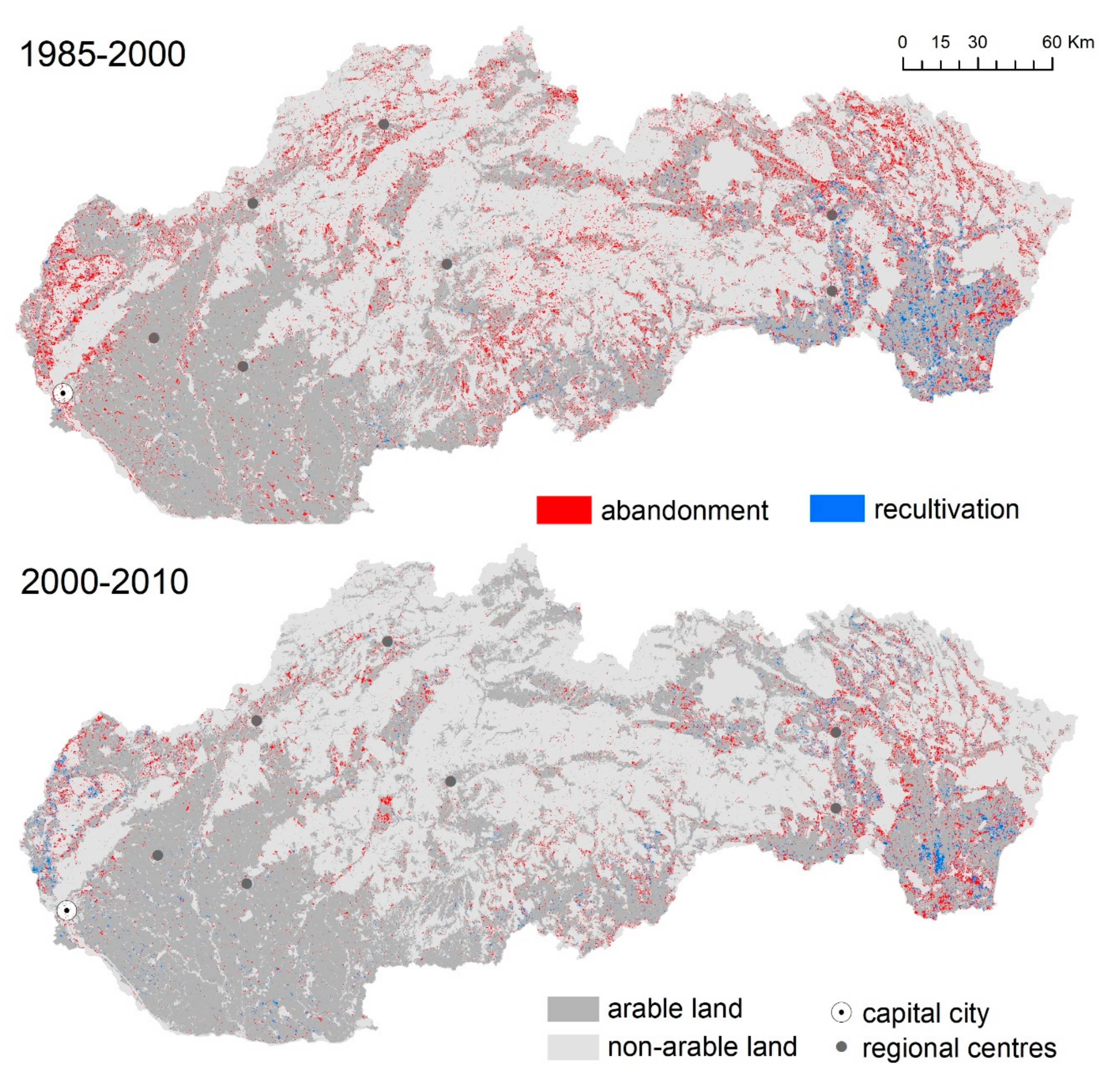
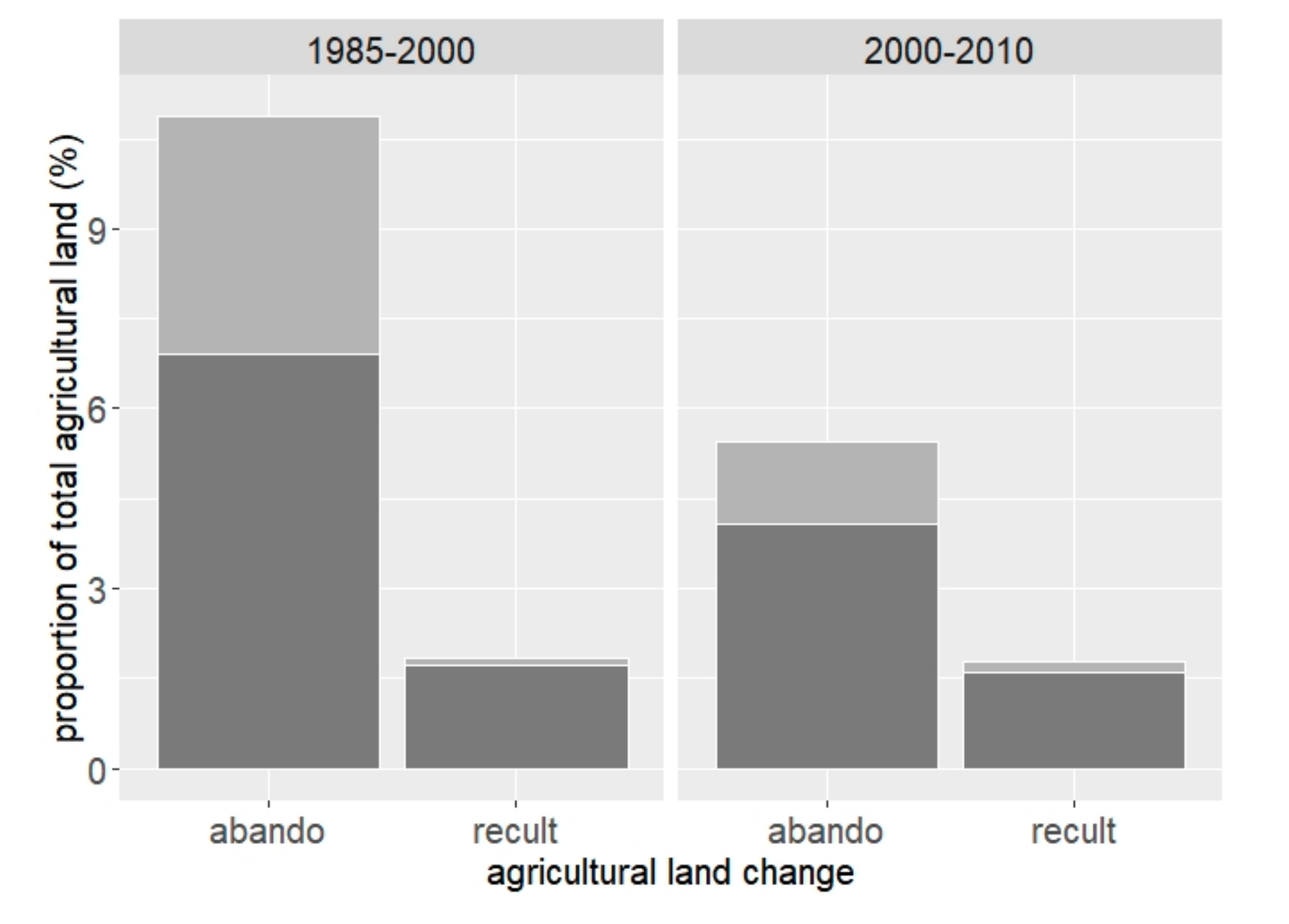
- describe the patterns of agricultural land use change in Slovakia using Landsat-based maps for 1985–2000 (transition period) and 2000–2010 (EU-accession);
- (2)
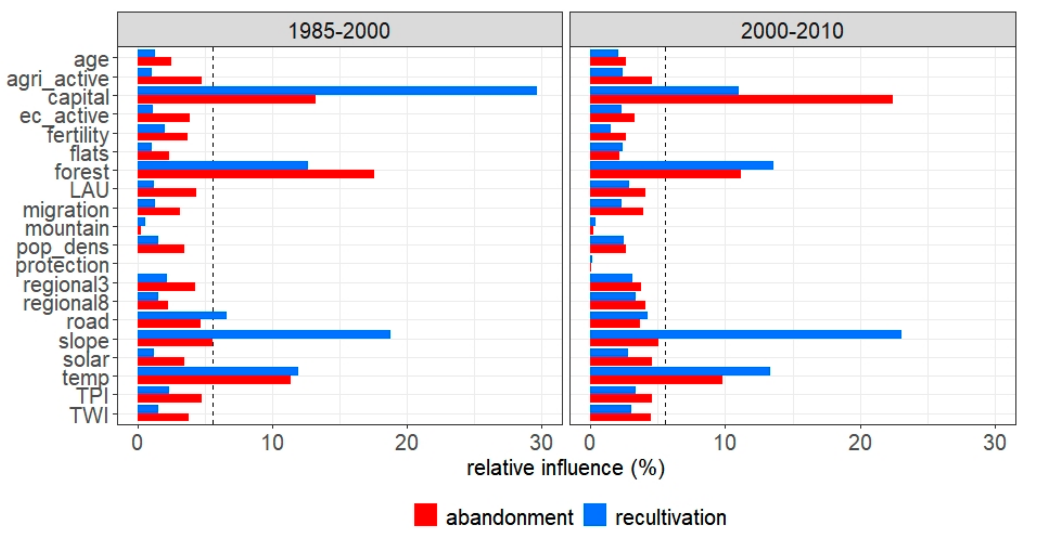
- quantify the influence of determinants on abandonment and recultivation of agricultural land for both periods;
- (3)
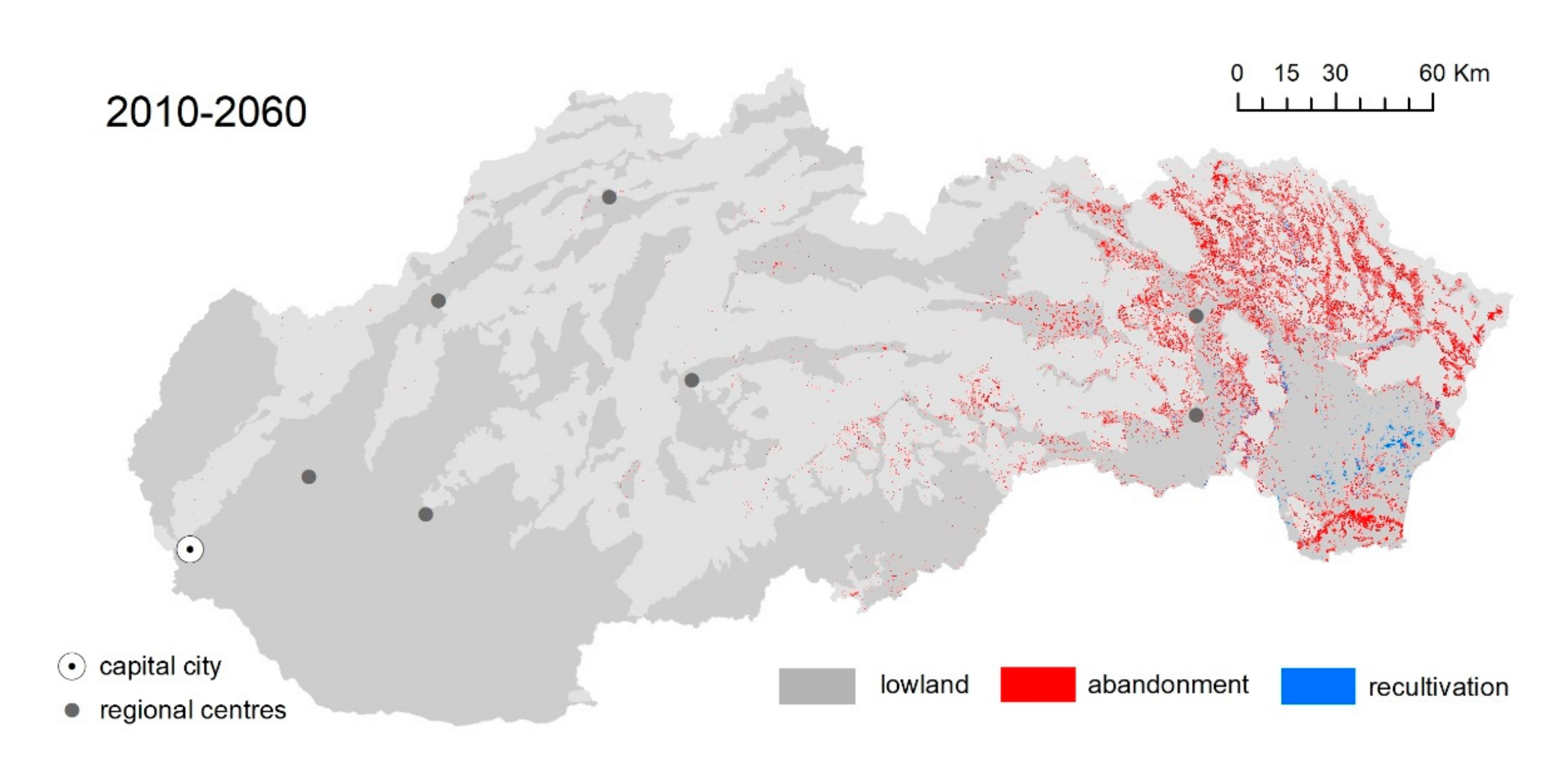
- assess agricultural land use change until 2060 based on a land change scenario.
2. Data and Methods
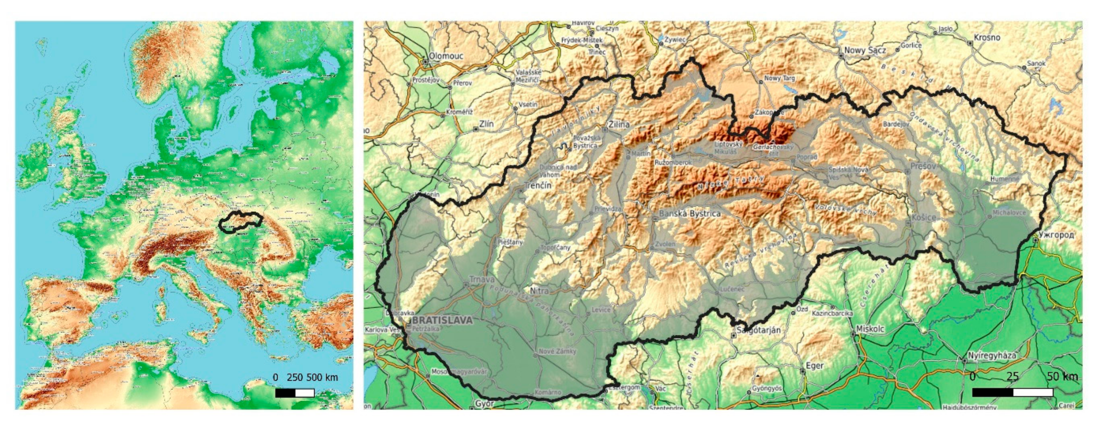
2.1. Study Area
2.2. Mapping Land Use Change
2.3. Determinants of Agricultural Land Use Change
2.4. Boosted Regression Trees
2.5. Parameterization of Boosted Regression Trees
2.6. Modeling Future Land Use Change
3. Results
3.1. Past Agricultural Land Use Change
3.2. Scenario of Future Agricultural Land Use Change
4. Discussion
4.1. Determinants of Agricultural Land Use Change
4.2. Agricultural Land Use Change Scenario
4.3. Accuracy of Land Change Assessment
4.4. Limitations of Our Models
4.5. Implications of Agricultural Land Change
5. Conclusions
Supplementary Materials
Author Contributions
Funding
Acknowledgments
Conflicts of Interest
References
- Foley, J.A.; DeFries, R.; Asner, G.P.; Barford, C.; Bonan, G.; Carpenter, S.R.; Chapin, F.S.; Coe, M.T.; Daily, G.C.; Gibbs, H.K.; et al. Global consequences of land use. Science 2005, 309, 570–574. [Google Scholar] [CrossRef] [PubMed] [Green Version]
- Lambin, E.F.; Geist, H.J.; Lepers, E. Dynamics ofland-use andland-coverchange intropicalregions. Annu. Rev. Environ. Resour. 2003, 28, 205–241. [Google Scholar] [CrossRef] [Green Version]
- Cramer, V.A.; Hobbs, R.; Standish, R. What’s new about old fields? Land abandonment and ecosystem assembly. Trends Ecol. Evol. 2008, 23, 104–112. [Google Scholar] [CrossRef] [PubMed]
- Bragina, E.; Radeloff, V.; Baumann, M.; Wendland, K.; Kuemmerle, T.; Pidgeon, A.M. Effectiveness of protected areas in the Western Caucasus before and after the transition to post-socialism. Biol. Conserv. 2015, 184, 456–464. [Google Scholar] [CrossRef]
- Macdonald, D.; Crabtree, J.; Wiesinger, G.; Dax, T.; Stamou, N.; Fleury, P.; Lazpita, J.G.; Gibon, A. Agricultural abandonment in mountain areas of Europe: Environmental consequences and policy response. J. Environ. Manag. 2000, 59, 47–69. [Google Scholar] [CrossRef]
- Estel, S.; Kuemmerle, T.; Alcantara, C.; Levers, C.; Prishchepov, A.V.; Hostert, P. Mapping farmland abandonment and recultivation across Europe using MODIS NDVI time series. Remote. Sens. Environ. 2015, 163, 312–325. [Google Scholar] [CrossRef]
- Kuemmerle, T.; Levers, C.; Erb, K.; Estel, S.; Jepsen, M.R.; Müller, D.; Plutzar, C.; Stürck, J.; Verkerk, P.J.; Verburg, P.H.; et al. Hotspots of land use change in Europe. Environ. Res. Lett. 2016, 11, 64020. [Google Scholar] [CrossRef]
- Lesiv, M.; Schepaschenko, D.; Moltchanova, E.; Bun, R.; Dürauer, M.; Prishchepov, A.V.; Schierhorn, F.; Estel, S.; Kuemmerle, T.; Alcántara, C.; et al. Spatial distribution of arable and abandoned land across former Soviet Union countries. Sci. Data 2018, 5, 180056. [Google Scholar] [CrossRef]
- Rozelle, S.; Swinnen, J.F.M. Success and failure of reform: Insights from the transition of agriculture. J. Econ. Lit. 2004, 42, 404–456. [Google Scholar] [CrossRef] [Green Version]
- Lerman, Z.; Csaki, C.; Feder, G. Land policies and Evolving Farm. Structures in Transition Countries. The World Bank: Washington, DC, USA, 2002. [Google Scholar]
- Prokopová, M.; Cudlín, O.; Včeláková, R.; Lengyel, S.; Salvati, L.; Cudlín, P. Latent drivers of landscape transformation in Eastern Europe: Past, present and future. Sustainability 2018, 10, 2918. [Google Scholar] [CrossRef] [Green Version]
- Skokanová, H.; Falťan, V.; Havlíček, M. Driving forces of main landscape change processes from past 200 years in Central Europe—Differences between old democratic and post-socialist countries. Ekológia 2016, 35, 50–65. [Google Scholar] [CrossRef] [Green Version]
- Kuemmerle, T.; Hostert, P.; Radeloff, V.C.; Van Der Linden, S.; Perzanowski, K.; Kruhlov, I. Cross-border comparison of post-socialist farmland abandonment in the Carpathians. Ecosystems 2008, 11, 614–628. [Google Scholar] [CrossRef]
- Prishchepov, A.V.; Müller, D.; Baumann, M.; Kuemmerle, T.; Alcantara, C.; Radeloff, V.C. Underlying drivers and spatial determinants of post-soviet agricultural land abandonment in temperate Eastern Europe. In Land-Cover and Land-Use Changes in Eastern Europe after the Collapse of the Soviet Union in 1991; Springer International Publishing: Cham, Switzerland, 2016; pp. 91–117. [Google Scholar]
- Alix-Garcia, J.; Munteanu, C.; Zhao, N.; Potapov, P.V.; Prishchepov, A.V.; Radeloff, V.C.; Krylov, A.; Bragina, E. Drivers of forest cover change in Eastern Europe and European Russia, 1985–2012. Land Use Policy 2016, 59, 284–297. [Google Scholar] [CrossRef]
- Ustaoglu, E.; Collier, M.J. Farmland abandonment in Europe: An overview of drivers, consequences, and assessment of the sustainability implications. Environ. Rev. 2018, 26, 396–416. [Google Scholar] [CrossRef]
- Alix-Garcia, J.; Kuemmerle, T.; Radeloff, V.C. Prices, land tenure institutions, and geography: A matching analysis of farmland abandonment in post-socialist Eastern Europe. Land Econ. 2012, 88, 425–443. [Google Scholar] [CrossRef]
- Ioffe, G.; Nefedova, T. Marginal farmland in European Russia. Eurasian Geogr. Econ. 2004, 45, 45–59. [Google Scholar] [CrossRef]
- Müller, D.; Leitão, P.J.; Sikor, T. Comparing the determinants of cropland abandonment in Albania and Romania using boosted regression trees. Agric. Syst. 2013, 117, 66–77. [Google Scholar] [CrossRef]
- Prishchepov, A.V.; Müller, D.; Dubinin, M.; Baumann, M.; Radeloff, V.C. Determinants of agricultural land abandonment in post-Soviet European Russia. Land Use Policy 2013, 30, 873–884. [Google Scholar] [CrossRef] [Green Version]
- Pazur, R.; Lieskovský, J.; Feranec, J.; Otahel, J. Spatial determinants of abandonment of large-scale arable lands and managed grasslands in Slovakia during the periods of post-socialist transition and European Union accession. Appl. Geogr. 2014, 54, 118–128. [Google Scholar] [CrossRef]
- Meyfroidt, P. Approaches and terminology for causal analysis in land systems science. J. Land Use Sci. 2015, 11, 501–522. [Google Scholar] [CrossRef]
- Bezák, P.; Mitchley, J. Drivers of change in mountain farming in Slovakia: From socialist collectivisation to the Common Agricultural Policy. Reg. Environ. Chang. 2014, 14, 1343–1356. [Google Scholar] [CrossRef]
- Némethová, J.; Dubcová, A.; Kramáreková, H. The Impacts of the European Union’s Common Agricultural Policy on Agriculture in Slovakia/Dopady společné zemědělské politiky Evropské unie na zemědělství Slovenska. Morav. Geogr. Rep. 2014, 22, 51–64. [Google Scholar] [CrossRef] [Green Version]
- Kolecka, N.; Kozak, J.; Kaim, D.; Dobosz, M.; Ostafin, K.; Ostapowicz, K.; Wężyk, P.; Price, B. Understanding farmland abandonment in the Polish Carpathians. Appl. Geogr. 2017, 88, 62–72. [Google Scholar] [CrossRef]
- Halada, L.; David, S.; Hreško, J.; Klimantová, A.; Bača, A.; Rusňák, T.; Buraľ, M.; Vadel, Ľ. Changes in grassland management and plant diversity in a marginal region of the Carpathian Mts in 1999–2015. Sci. Total. Environ. 2017, 609, 896–905. [Google Scholar] [CrossRef] [PubMed]
- Griffiths, P.; Müller, D.; Kuemmerle, T.; Hostert, P. Agricultural land change in the Carpathian ecoregion after the breakdown of socialism and expansion of the European Union. Environ. Res. Lett. 2013, 8, 045024. [Google Scholar] [CrossRef]
- Renwick, A.; Jansson, T.; Verburg, P.H.; Revoredo-Giha, C.; Britz, W.; Gocht, A.; McCracken, D. Policy reform and agricultural land abandonment in the EU. Land Use Policy 2013, 30, 446–457. [Google Scholar] [CrossRef]
- Kanianska, R.; Kizeková, M.; Nováček, J.; Zeman, M. Land-use and land-cover changes in rural areas during different political systems: A case study of Slovakia from 1782 to 2006. Land Use Policy 2014, 36, 554–566. [Google Scholar] [CrossRef]
- Midriak, R.; Zaušková, Ľ. Pustnutie pôdy a pustnutie krajiny Slovenska. Geogr. Cassoviensis 2011, 5, 79–83. [Google Scholar]
- Lieskovský, J.; Bezák, P.; Špulerová, J.; Lieskovský, T.; Koleda, P.; Dobrovodská, M.; Bürgi, M.; Gimmi, U. The abandonment of traditional agricultural landscape in Slovakia—Analysis of extent and driving forces. J. Rural. Stud. 2015, 37, 75–84. [Google Scholar] [CrossRef]
- Slamová, M.; Belčáková, I. The role of small farm activities for the sustainable management of agricultural landscapes: Case studies from Europe. Sustainability 2019, 11, 5966. [Google Scholar] [CrossRef] [Green Version]
- Šebo, D.; Kopecká, M. Abandonment of agricultural landscape after 1989: A case study from the Považie Region, Slovakia. Geogr. Cas. 2014, 66, 323–339. [Google Scholar]
- Špulerová, J.; Dobrovodská, M.; Štefunková, D.; Bača, A.; Lieskovský, J. Biodiversity of traditional agricultural landscapes in Slovakia and their threats. In Biocultural Landscapes: Diversity, Functions and Values; Hong, S.K., Bogaert, J., Min, Q., Eds.; Springer: Dordrecht, The Netherlands, 2014; ISBN 978-94-017-8941-7. [Google Scholar]
- Dobrovodská, M.; Kanka, R.; David, S.; Kollár, J.; Špulerová, J.; Štefunková, D.; Mojses, M.; Petrovič, F.; Krištín, A.; Stašiov, S.; et al. Assessment of the biocultural value of traditional agricultural landscape on a plot-by-plot level: Case studies from Slovakia. Biodivers. Conserv. 2019, 28, 2615–2645. [Google Scholar] [CrossRef]
- Bezák, P.; Dobrovodská, M. Role of rural identity in traditional agricultural landscape maintenance: The story of a post-communist country. Agroecol. Sustain. Food Syst. 2018, 43, 3–20. [Google Scholar] [CrossRef]
- NAFC. Ex Post Evaluation of the SAPARD Programme in the SR. Final Report of the Ex-Post Evaluation of the SAPARD Programme in Slovakia 2000–2006; The Reasearch Institute of Agricultural and Food Economics: Bratislava, Slovakia, 2009. [Google Scholar]
- Feranec, J.; Šúri, M.; Ot’Ahel’, J.; Cebecauer, T.; Kolář, J.; Soukup, T.; Zdeňková, D.; Waszmuth, J.; Vâjdea, V.; Vîjdea, A.M.; et al. Inventory of major landscape changes in the Czech Republic, Hungary, Romania and Slovak Republic 1970s–1990s. Int. J. Appl. Earth Obs. Geoinf. 2000, 2, 129–139. [Google Scholar] [CrossRef]
- Habel, J.C.; Dengler, J.; Janišová, M.; Török, P.; Wellstein, C.; Wiezik, M. European grassland ecosystems: Threatened hotspots of biodiversity. Biodivers. Conserv. 2013, 22, 2131–2138. [Google Scholar] [CrossRef] [Green Version]
- Olah, B.; Boltižiar, M.; Petrovič, F. Land use changes’ relation to georelief and distance in the East Carpathians Biosphere Reserve. Ekol. Bratislava 2006, 25, 68–81. [Google Scholar]
- Olàh, B.; Boltiziar, M. Land use changes within the Slovak biosphere reserves’ zones. Ekológia 2009, 28, 127–142. [Google Scholar] [CrossRef] [Green Version]
- Müller, D.; Munroe, D.K. Changing rural landscapes in Albania: Cropland abandonment and forest clearing in the postsocialist transition. Ann. Assoc. Am. Geogr. 2008, 98, 855–876. [Google Scholar] [CrossRef]
- Baumann, M.; Kuemmerle, T.; Elbakidze, M.; Özdoğan, M.; Radeloff, V.C.; Keuler, N.S.; Prishchepov, A.V.; Kruhlov, I.; Hostert, P. Patterns and drivers of post-socialist farmland abandonment in Western Ukraine. Land Use Policy 2011, 28, 552–562. [Google Scholar] [CrossRef]
- Dara, A.; Baumann, M.; Kuemmerle, T.; Pflugmacher, D.; Rabe, A.; Griffiths, P.; Hölzel, N.; Kamp, J.; Freitag, M.; Hostert, P. Mapping the timing of cropland abandonment and recultivation in northern Kazakhstan using annual Landsat time series. Remote Sens. Environ. 2018, 213, 49–60. [Google Scholar] [CrossRef]
- Krämer, R.; Prishchepov, A.V.; Müller, D.; Kuemmerle, T.; Radeloff, V.C.; Dara, A.; Terekhov, A.; Frühauf, M. Long-term agricultural land-cover change and potential for cropland expansion in the former Virgin Lands area of Kazakhstan. Environ. Res. Lett. 2015, 10, 054012. [Google Scholar] [CrossRef]
- De Beurs, K.M.; Henebry, G.M. Land surface phenology, climatic variation, and institutional change: Analyzing agricultural land cover change in Kazakhstan. Remote Sens. Environ. 2004, 89, 497–509. [Google Scholar] [CrossRef]
- Kuemmerle, T.; Kozak, J.; Radeloff, V.C.; Hostert, P. Differences in forest disturbance among land ownership types in Poland during and after socialism. J. Land Use Sci. 2009, 4, 73–83. [Google Scholar] [CrossRef]
- Meyfroidt, P.; Schierhorn, F.; Prishchepov, A.V.; Müller, D.; Kuemmerle, T. Drivers, constraints and trade-offs associated with recultivating abandoned cropland in Russia, Ukraine and Kazakhstan. Glob. Environ. Chang. 2016, 37, 1–15. [Google Scholar] [CrossRef]
- Yin, H.; Prishchepov, A.V.; Kuemmerle, T.; Bleyhl, B.; Buchner, J.; Radeloff, V.C. Mapping agricultural land abandonment from spatial and temporal segmentation of Landsat time series. Remote Sens. Environ. 2018, 210, 12–24. [Google Scholar] [CrossRef]
- Prishchepov, A.V.; Radeloff, V.C.; Dubinin, M.; Alcantara, C. The effect of Landsat ETM/ETM+ image acquisition dates on the detection of agricultural land abandonment in Eastern Europe. Remote Sens. Environ. 2012, 126, 195–209. [Google Scholar] [CrossRef]
- Alcamo, J. Scenarios as Tools for International Environmental Assessments. Centre for Environmental Systems Research, University of Kassel: Kassel, Germany, 2001; ISBN 9291674028. [Google Scholar]
- Prishchepov, A.V.; Ponkina, E.; Sun, Z.; Müller, D. Revealing the determinants of wheat yields in the Siberian breadbasket of Russia with Bayesian networks. Land Use Policy 2019, 80, 21–31. [Google Scholar] [CrossRef] [Green Version]
- Statistical Office of the Slovak Republic. Annual Report of Statistical Office of the SR; Statistical Office of the Slovak Republic: Bratislava, Slovakia, 2018. [Google Scholar]
- Oťaheľ, J. Prírodna Štruktúra Krajiny. Institute of Geography: Bratislava, Slovakia, 2010; Volume 1. [Google Scholar]
- Jepsen, M.R.; Kuemmerle, T.; Müller, D.; Erb, K.; Verburg, P.H.; Haberl, H.; Vesterager, J.P.; Andrič, M.; Antrop, M.; Austrheim, G.; et al. Transitions in European land-management regimes between 1800 and 2010. Land Use Policy 2015, 49, 53–64. [Google Scholar] [CrossRef]
- Lieskovský, J.; Kenderessy, P.; Špulerová, J.; Lieskovský, T.; Koleda, P.; Kienast, F.; Gimmi, U. Factors affecting the persistence of traditional agricultural landscapes in Slovakia during the collectivization of agriculture. Landsc. Ecol. 2014, 29, 867–877. [Google Scholar] [CrossRef] [Green Version]
- Jamborová, M.; Masár, I. Vývojové tendencie zamestnanosti vagrárnom sektore a v potravinárskej výrobe v poslednej dekáde (2005–2014) na Slovensku. Econ. Agric. 2015, 15, 109–123. [Google Scholar]
- Pazúr, R.; Bolliger, J. Land changes in Slovakia: Past processes and future directions. Appl. Geogr. 2017, 85, 163–175. [Google Scholar] [CrossRef]
- Lieskovský, J.; Kanka, R.; Bezák, P.; Štefunková, D.; Petrovič, F.; Dobrovodská, M. Driving forces behind vineyard abandonment in Slovakia following the move to a market-oriented economy. Land Use Policy 2013, 32, 356–365. [Google Scholar] [CrossRef]
- Jansen, L.J.; Veldkamp, A. Evaluation of the variation in semantic contents of class sets on modelling dynamics of land-use changes. Int. J. Geogr. Inf. Sci. 2012, 26, 717–746. [Google Scholar] [CrossRef]
- Plieninger, T.; Draux, H.; Fagerholm, N.; Bieling, C.; Bürgi, M.; Kizos, A.; Kuemmerle, T.; Primdahl, J.; Verburg, P.H. The driving forces of landscape change in Europe: A systematic review of the evidence. Land Use Policy 2016, 57, 204–214. [Google Scholar] [CrossRef] [Green Version]
- Van Vliet, J.; De Groot, H.L.; Rietveld, P.; Verburg, P.H. Manifestations and underlying drivers of agricultural land use change in Europe. Landsc. Urban Plan. 2015, 133, 24–36. [Google Scholar] [CrossRef]
- Verburg, P.H.; Van Eck, J.R.; De Nijs, T.C.M.; Dijst, M.J.; Schot, P. Determinants of land-use change patterns in the Netherlands. Environ. Plan. B Plan. Des. 2004, 31, 125–150. [Google Scholar] [CrossRef] [Green Version]
- GCI. Topographic Database for the Geographic Information System (ZBGIS); Geodetic and Cartographic Institute Bratislava, Slovakia. Available online: https://www.geoportal.sk/en/archiv/ (accessed on 6 September 2020).
- ESRI. ArcGIS Desktop: Release 10.3 Environmental Systems Research Institute; ESRI: Redlands, CA, USA, 2016. [Google Scholar]
- Jenness, J.; Brost, B.; Beier, P. Land Facet Corridor Designer: Extension for ArcGIS; Jenness Enterprises: Flagstaff, AZ, USA, 2003. [Google Scholar]
- Kopecký, M.; Čížková, Š. Using topographic wetness index in vegetation ecology: Does the algorithm matter? Appl. Veg. Sci. 2010, 13, 450–459. [Google Scholar] [CrossRef]
- Džatko, M. Hodnotenie Produkčného Potenciálu Poľnohospodárskych Pôd a Pôdno-Ekologických Regiónov Slovenska; Výskumný Ústav Pôdoznalectva a Ochrany Pôdy: Bratislava, Slovakia, 2002; ISBN 8085361949. [Google Scholar]
- Karger, D.N.; Conrad, O.; Böhner, J.; Kawohl, T.; Kreft, H.; Soria-Auza, R.W.; Zimmermann, N.E.; Linder, H.P.; Kessler, M. CHELSA Climatologies at High Resolution for the Earth’s Land Surface Areas (Version 1.1). World Data Cent. Clim. 2016. [Google Scholar] [CrossRef]
- EEA Natura 2000 Database and GIS. Available online: https://ec.europa.eu/environment/nature/natura2000/db_gis/index_en.htm (accessed on 2 September 2019).
- Lieskovský, J.; Lieskovský, T.; Piscová, V. Physical accessibility and its role in landscape development—Three historical analyses from South Slovakia. Landsc. Res. 2017, 42, 498–507. [Google Scholar] [CrossRef]
- Soule, R.G.; Goldman, R.F. Terrain coefficients for energy cost prediction. J. Appl. Physiol. 1972, 32, 706–708. [Google Scholar] [CrossRef]
- Mezníková, L. Analýza Nejkratších cest na Mapách pro Orientační běh; Czech Technical University in Prague: Prague, Czech Republic, 2011. [Google Scholar]
- Irwin, E.G.; Geoghegan, J. Theory, data, methods: Developing spatially explicit economic models of land use change. Agric. Ecosyst. Environ. 2001, 85, 7–24. [Google Scholar] [CrossRef] [Green Version]
- Müller, D.; Kuemmerle, T.; Rusu, M.; Griffiths, P. Lost in transition: Determinants of post-socialist cropland abandonment in Romania. J. Land Use Sci. 2009, 4, 109–129. [Google Scholar] [CrossRef]
- Gellrich, M.; Baur, P.; Koch, B.; Zimmermann, N.E. Agricultural land abandonment and natural forest re-growth in the Swiss mountains: A spatially explicit economic analysis. Agric. Ecosyst. Environ. 2007, 118, 93–108. [Google Scholar] [CrossRef]
- Corbelle, E.; Crecente, R.; Santé, I. Multi-scale assessment and spatial modelling of agricultural land abandonment in a European peripheral region: Galicia (Spain), 1956–2004. Land Use Policy 2012, 29, 493–501. [Google Scholar] [CrossRef]
- Smaliychuk, A.; Müller, D.; Prishchepov, A.V.; Levers, C.; Kruhlov, I.; Kuemmerle, T. Recultivation of abandoned agricultural lands in Ukraine: Patterns and drivers. Glob. Environ. Chang. 2016, 38, 70–81. [Google Scholar] [CrossRef]
- Levers, C.; Schneider, M.; Prishchepov, A.V.; Estel, S.; Kuemmerle, T. Spatial variation in determinants of agricultural land abandonment in Europe. Sci. Total. Environ. 2018, 644, 95–111. [Google Scholar] [CrossRef]
- Atkinson, P.M.; Massari, R. Autologistic modelling of susceptibility to landsliding in the Central Apennines, Italy. Geomorphology 2011, 130, 55–64. [Google Scholar] [CrossRef]
- Levers, C.; Verkerk, P.J.; Müller, D.; Verburg, P.H.; Butsic, V.; Leitão, P.J.; Lindner, M.; Kuemmerle, T. Drivers of forest harvesting intensity patterns in Europe. For. Ecol. Manag. 2014, 315, 160–172. [Google Scholar] [CrossRef]
- Friedman, J.; Hastie, T.; Tibshirani, R. Additive logistic regression: A statistical view of boosting (with discussion and a rejoinder by the authors). Ann. Stat. 2000, 28, 337–407. [Google Scholar] [CrossRef]
- Elith, J.; Leathwick, J.R.; Hastie, T. A working guide to boosted regression trees. J. Anim. Ecol. 2008, 77, 802–813. [Google Scholar] [CrossRef]
- Hastie, T.; Tibshirani, R.; Friedman, J. The Elements of Statistical Learning; Springer Series in Statistics; Springer: New York, NY, USA, 2009; ISBN 978-0-387-84857-0. [Google Scholar]
- James, G.; Witten, D.; Hastie, T.; Tibshirani, R. An Introduction to Statistical Learning—With Applications in R; Springer: New York, NY, USA, 2013; ISBN 9781461471370. [Google Scholar]
- Hijmans, R.J.; Elith, J. Species distribution modeling with R. 2013, pp. 1–79. Available online: http://citeseerx.ist.psu.edu/viewdoc/download?doi=10.1.1.190.9177&rep=rep1&type=pdf (accessed on 2 September 2020).
- Pontius, R.G.; Parmentier, B. Recommendations for using the relative operating characteristic (ROC). Landsc. Ecol. 2014, 29, 367–382. [Google Scholar] [CrossRef]
- IPCC. Climate Change 2014: Synthesis Report. Contribution of Working Groups I, II and III to the Fifth Assessment Report of the Intergovernmental Panel on Climate Change; Pachauri, R.K., Meyer, L.A., Eds.; IPPC: Geneva, Switzerland, 2014; p. 151. [Google Scholar]
- VÚPOP. Soil Units Nomenclature According to the ‘Morphogenetic Soil Classification System of Slovakia’; Soil Science and Conservation Research Institute: Bratislava, Slovakia, 2000. [Google Scholar]
- Verburg, P.H.; Overmars, K.P. Combining top-down and bottom-up dynamics in land use modeling: Exploring the future of abandoned farmlands in Europe with the Dyna-CLUE model. Landsc. Ecol. 2009, 24, 1167–1181. [Google Scholar] [CrossRef]
- Lasanta, T.; Arnáez, J.; Pascual, N.; Ruiz-Flaño, P.; Errea, M.; Lana-Renault, N.; Ruiz, P. Space–time process and drivers of land abandonment in Europe. Catena 2017, 149, 810–823. [Google Scholar] [CrossRef]
- Shaw, B.J.; Van Vliet, J.; Verburg, P.H. The peri-urbanization of Europe: A systematic review of a multifaceted process. Landsc. Urban. Plan. 2020, 196, 103733. [Google Scholar] [CrossRef]
- Pazúr, R.; Feranec, J.; Štych, P.; Kopecká, M.; Holman, L. Changes of urbanised landscape identified and assessed by the Urban Atlas data: Case study of Prague and Bratislava. Land Use Policy 2017, 61, 135–146. [Google Scholar] [CrossRef]
- Grădinaru, S.R.; Iojă, C.I.; Onose, D.A.; Gavrilidis, A.A.; Pătru-Stupariu, I.; Kienast, F.; Hersperger, A.M. Land abandonment as a precursor of built-up development at the sprawling periphery of former socialist cities. Ecol. Indic. 2015, 57, 305–313. [Google Scholar] [CrossRef]
- Hatna, E.; Bakker, M.M. Abandonment and expansion of arable land in Europe. Ecosystems 2011, 14, 720–731. [Google Scholar] [CrossRef] [Green Version]
- Lieskovský, J.; Bürgi, M. Persistence in cultural landscapes: A pan-European analysis. Reg. Environ. Chang. 2017, 18, 175–187. [Google Scholar] [CrossRef]
- Tasser, E.; Walde, J.; Tappeiner, U.; Teutsch, A.; Noggler, W. Land-use changes and natural reforestation in the Eastern Central Alps. Agric. Ecosyst. Environ. 2007, 118, 115–129. [Google Scholar] [CrossRef]
- Bolliger, J.; Schmatz, D.; Psomas, A.; Pazúr, R.; Ostapowicz, K. Reconstructing forest-cover change in the Swiss Alps between 1880 and 2010 using ensemble modelling. Reg. Environ. Chang. 2017, 17, 2265–2277. [Google Scholar] [CrossRef]
- Druga, M.; Falťan, V. Influences of environmental drivers on land cover structure and its long-term changes: A case study of the villages of Malachov and Podkonice in Slovakia/Vliv environmentálních podmínek na strukturu krajinného pokryvu a její dlouhodobé změny: Případová Studie Obcí Malachov a Podkonice na Slovensku. Morav. Geogr. Rep. 2014, 22, 29–41. [Google Scholar] [CrossRef] [Green Version]
- Masný, M.; Weis, K.; Boltižiar, M. Agricultural abandonment in chosen terrain attributes context—Case study from the poľana unesco biosphere reserve (Central Slovakia). Ekológia 2017, 36, 339–351. [Google Scholar] [CrossRef] [Green Version]
- Meiyappan, P.; Dalton, M.; O’Neill, B.C.; Jain, A.K. Spatial modeling of agricultural land use change at global scale. Ecol. Model. 2014, 291, 152–174. [Google Scholar] [CrossRef] [Green Version]
- Van Asselen, S.; Verburg, P.H. Land cover change or land-use intensification: Simulating land system change with a global-scale land change model. Glob. Chang. Biol. 2013, 19, 3648–3667. [Google Scholar] [CrossRef] [PubMed]
- Verburg, P.H.; Ellis, E.C.; Letourneau, A. A global assessment of market accessibility and market influence for global environmental change studies. Environ. Res. Lett. 2011, 6, 034019. [Google Scholar] [CrossRef]
- Masný, M.; Zaušková, L. The abandonment of agricultural land: A case study of strelníky, (The pol’ana biosphere reserve—Slovakia). Carpathian J. Earth Environ. Sci. 2014, 9, 17–24. [Google Scholar]
- Bakker, M.; Hatna, E.; Kuhlman, T.; Mücher, S. Changing environmental characteristics of European cropland. Agric. Syst. 2011, 104, 522–532. [Google Scholar] [CrossRef]
- Blacksell, M. Agriculture and landscape in the 21st century Europe: The post-communist transition. Eur. Countrys 2010, 2, 13–24. [Google Scholar] [CrossRef]
- Müller, D.; Kuemmerle, T. Causes of cropland abandonment during the post-socialist transition in Southern Romania. Clim. Interact. 2009, 221–230. [Google Scholar] [CrossRef]
- Levers, C.; Müller, D.; Erb, K.; Haberl, H.; Jepsen, M.R.; Metzger, M.J.; Meyfroidt, P.; Plieninger, T.; Plutzar, C.; Stürck, J.; et al. Archetypical patterns and trajectories of land systems in Europe. Reg. Environ. Chang. 2015, 18, 715–732. [Google Scholar] [CrossRef]
- Munteanu, C.; Radeloff, V.; Griffiths, P.; Halada, L.; Kaim, D.; Knorn, J.; Kozak, J.; Kuemmerle, T.; Lieskovský, J.; Müller, D.; et al. Land change in the Carpathian region before and after major institutional changes. In Land-Cover and Land-Use Changes in Eastern Europe after the Collapse of the Soviet Union in 1991; Gutman, G., Radeloff, V., Eds.; Springer International Publishing: Cham, Switzerland, 2017; pp. 57–90. ISBN 978-3-319-42638-9. [Google Scholar]
- Meyfroidt, P.; Lambin, E.F.; Erb, K.-H.; Hertel, B.T.W. Globalization of land use: Distant drivers of land change and geographic displacement of land use. Curr. Opin. Environ. Sustain. 2013, 5, 438–444. [Google Scholar] [CrossRef]
- Swinnen, J.; Burkitbayeva, S.; Schierhorn, F.; Prishchepov, A.V.; Müller, D. Production potential in the “bread baskets” of Eastern Europe and Central Asia. Glob. Food Secur. 2017, 14, 38–53. [Google Scholar] [CrossRef]
- Müller, D.; Sun, Z.; Vongvisouk, T.; Pflugmacher, D.; Xu, J.; Mertz, O. Regime shifts limit the predictability of land-system change. Glob. Environ. Chang. 2014, 28, 75–83. [Google Scholar] [CrossRef]
- Van Vuuren, D.P.; Edmonds, J.; Kainuma, M.; Riahi, K.; Thomson, A.; Hibbard, K.; Hurtt, G.C.; Kram, T.; Krey, V.; Lamarque, J.F.; et al. The representative concentration pathways: An overview. Clim. Chang. 2011, 109, 5–31. [Google Scholar] [CrossRef]
- Bičík, I.; Kabrda, J. Land use changes in Czech border regions (1845–2000). Acta Univ. Carolinae Geogr. 2007, 42, 23–52. [Google Scholar]
- Alcantara, C.; Kuemmerle, T.; Prishchepov, A.V.; Radeloff, V.C. Mapping abandoned agriculture with multi-temporal MODIS satellite data. Remote Sens. Environ. 2012, 124, 334–347. [Google Scholar] [CrossRef]
- Kuemmerle, T.; Hostert, P.; St-Louis, V.; Radeloff, V.C. Using image texture to map farmland field size: A case study in Eastern Europe. J. Land Use Sci. 2009, 4, 85–107. [Google Scholar] [CrossRef]
- Plieninger, T.; Van Der Horst, D.; Schleyer, C.; Bieling, C. Sustaining ecosystem services in cultural landscapes. Ecol. Soc. 2014, 19. [Google Scholar] [CrossRef]
- Stürck, J.; Levers, C.; Van Der Zanden, E.H.; Schulp, C.J.; Verkerk, P.J.; Kuemmerle, T.; Helming, J.; Lotze-Campen, H.; Tabeau, A.; Popp, A.; et al. Simulating and delineating future land change trajectories across Europe. Reg. Environ. Chang. 2015, 18, 733–749. [Google Scholar] [CrossRef] [Green Version]
- Hinojosa, L.; Napoléone, C.; Moulery, M.; Lambin, E.F. The “mountain effect” in the abandonment of grasslands: Insights from the French Southern Alps. Agric. Ecosyst. Environ. 2016, 221, 115–124. [Google Scholar] [CrossRef]
- Pe’er, G.; Lakner, S.; Passoni, G.; Azam, C.; Berger, J.; Hartmann, L.; Schüler, S.; Müller, R.; von Meyer-Höfer, M.; Zinngrebe, Y. Is the CAP Fit for Purpose? An Evidence-Based, Rapid Fitness-Check Assessment—Preliminary Summary of Key Outcomes; Stichting BirdLife Europe and the European Environmental Bureau: Leipzig, Germany, 2017. [Google Scholar]
- Špulerová, J.; Drábová, M.; Lieskovský, J. Traditional agricultural landscape and their management in less favoured areas in Slovakia. Ekológia 2016, 35, 1–12. [Google Scholar] [CrossRef] [Green Version]


| Variables | Abbreviation | Characteristics | Data Source |
|---|---|---|---|
| Biophysical | |||
| elevation * | elevation | DEM | [64] |
| slope | slope | DEM | [64] |
| sun radiation | solar | solar radiation model (kWh) [65] | [64] |
| topographic position index | TPI | [66] | [64] |
| topographic wetness index | TWI | [66] | [64] |
| relief subgroup | lowland | areas that belongs to the flatland or mountain relief | [54] |
| soil fertility | fertility | function of grain size distribution and soil type | [89] |
| protected sites | protection | all natural protected areas except large-area national parks | [64] |
| Climatic | |||
| temperature | temp | monthly means of temperature in 1985–2000 and 2000–2010 | [90] |
| rainfall * | rainfall | monthly means of rainfall in 1985–2000 and 2000–2010 | [90] |
| Accessibility &Isolation | |||
| distance to forested area | forest | cost-distance using DEM | [64], own calculations |
| distance to capital city | capital | cost-distance in minutes using the friction coefficients for different LU classes and DEM | [64], own calculations |
| distance to important cities | regional3 | cost-distance in minutes using the friction coefficients for different LU classes and DEM | [64], own calculations |
| distance to regional centers | regional8 | cost-distance in minutes using the friction coefficients for different LU classes and DEM | [64], own calculations |
| distance to LAU 1 (NUTS 4) centers | LAU | cost-distance in minutes using the friction coefficients for different LU classes and DEM | [64], own calculations |
| distance to communes * | settlement | cost-distance in minutes using the friction coefficients for different LU classes and DEM | [64], own calculations |
| distance to roads | road | cost-distance using DEM | [64], own calculations |
| Demographic | |||
| population density | pop_dens | population/km2 periods (1985–2000, 2000–2010) | [53] |
| age index | age | population over 65 y./population under 15y.* 100 (1985–2000, 2000–2010) | [53] |
| migration | migration | total migration/population (1985–2000, 2000–2010) | [53] |
| economic activity | ec_active | proportion of economic active people (1985–2000, 2000–2010) | [53] |
| agriculture activity | agri_active | proportion of people working in agriculture (1985–2000, 2000–2010) | [53] |
| flats | flats | flats/apartments build in previous decade/hectares (1985–2000, 2000–2010) | [53] |
© 2020 by the authors. Licensee MDPI, Basel, Switzerland. This article is an open access article distributed under the terms and conditions of the Creative Commons Attribution (CC BY) license (http://creativecommons.org/licenses/by/4.0/).
Share and Cite
Pazúr, R.; Lieskovský, J.; Bürgi, M.; Müller, D.; Lieskovský, T.; Zhang, Z.; Prishchepov, A.V. Abandonment and Recultivation of Agricultural Lands in Slovakia—Patterns and Determinants from the Past to the Future. Land 2020, 9, 316. https://0-doi-org.brum.beds.ac.uk/10.3390/land9090316
Pazúr R, Lieskovský J, Bürgi M, Müller D, Lieskovský T, Zhang Z, Prishchepov AV. Abandonment and Recultivation of Agricultural Lands in Slovakia—Patterns and Determinants from the Past to the Future. Land. 2020; 9(9):316. https://0-doi-org.brum.beds.ac.uk/10.3390/land9090316
Chicago/Turabian StylePazúr, Robert, Juraj Lieskovský, Matthias Bürgi, Daniel Müller, Tibor Lieskovský, Zhen Zhang, and Alexander V. Prishchepov. 2020. "Abandonment and Recultivation of Agricultural Lands in Slovakia—Patterns and Determinants from the Past to the Future" Land 9, no. 9: 316. https://0-doi-org.brum.beds.ac.uk/10.3390/land9090316