
Plio–Quaternary Structural Evolution of the Outer Sector of the Marche Apennines South of the Conero Promontory, Italy

 , and
, and 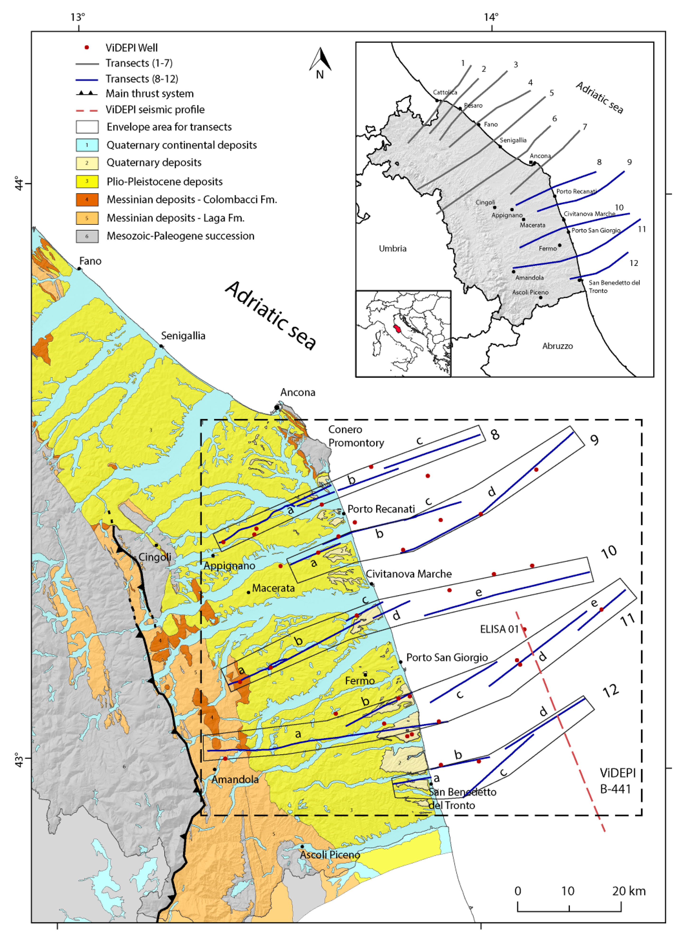
Abstract
:1. Introduction
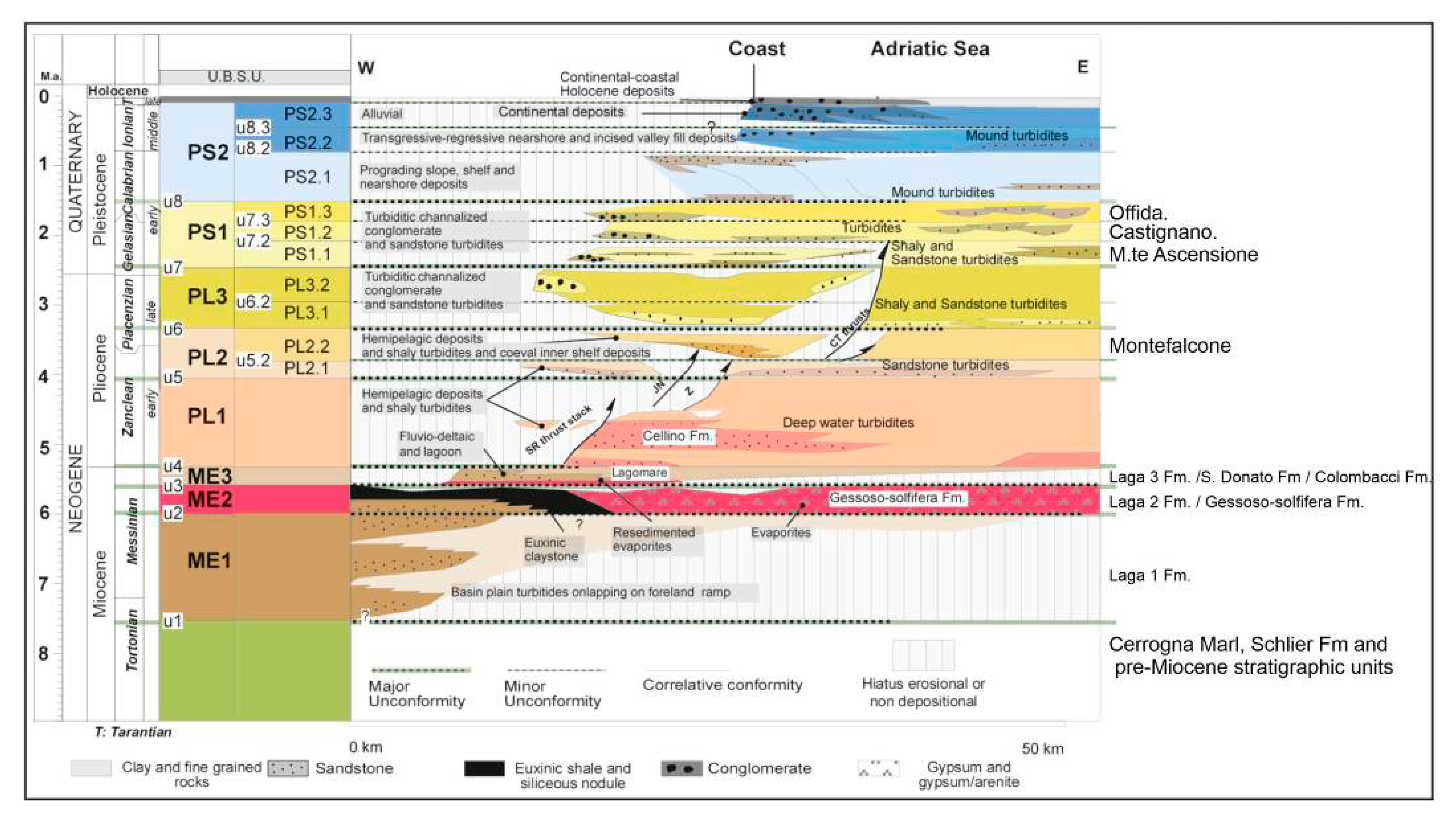
2. Geological Setting
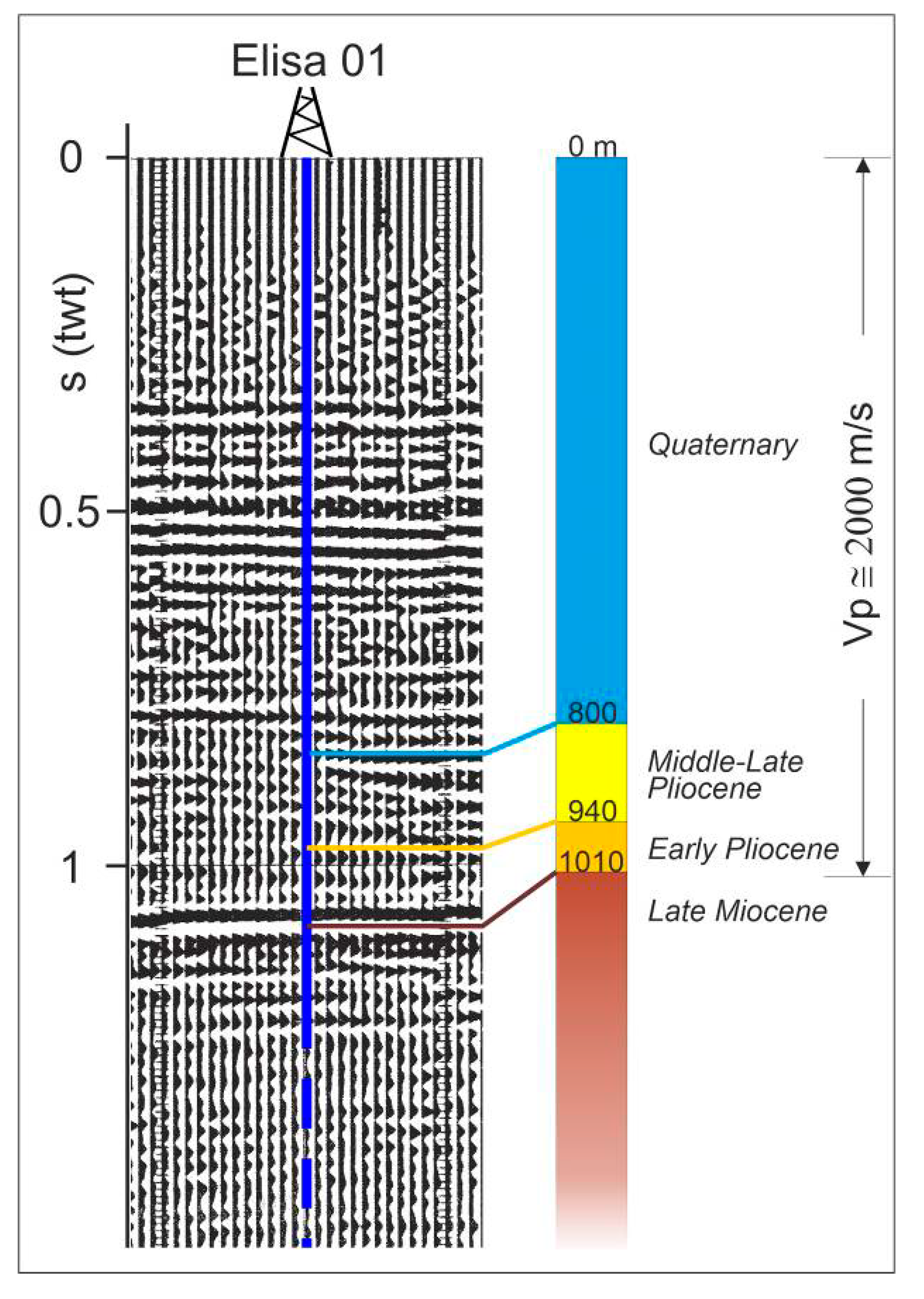
3. Dataset and Working Methods
- Top of the Messinian/Pre-Pliocene;
- Near the top of the Early Pliocene;
- Near the base of the Quaternary;
- Unconformities.
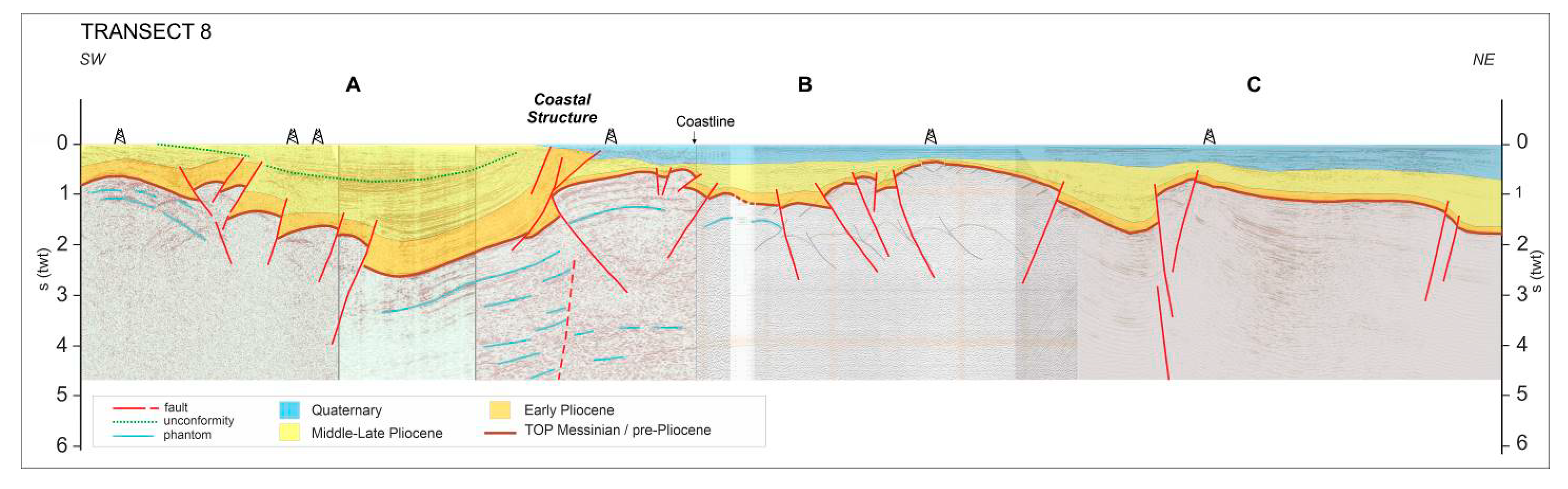
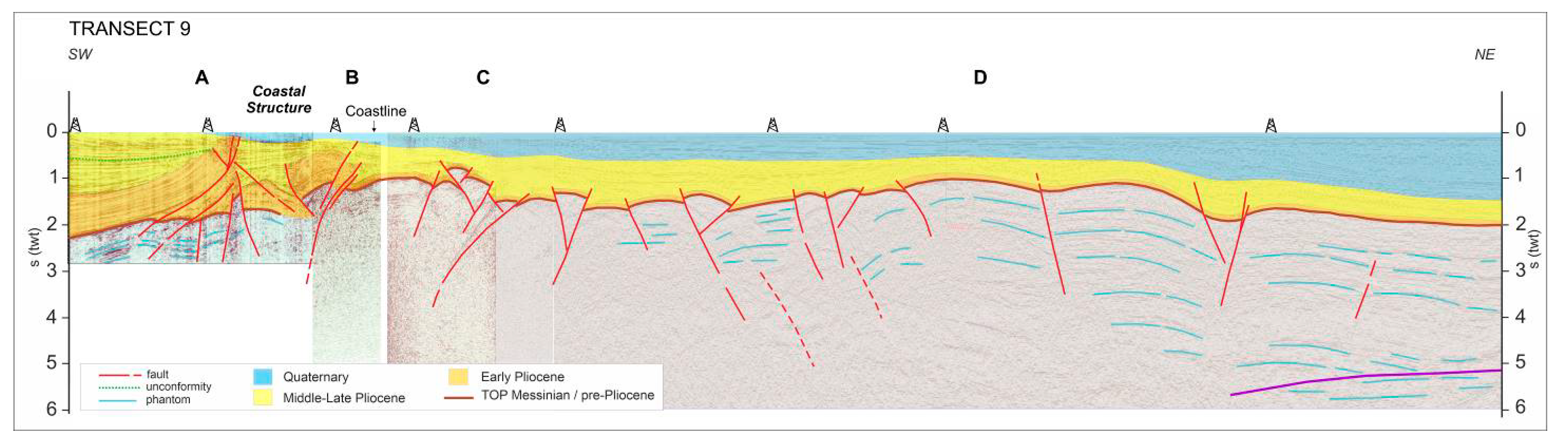
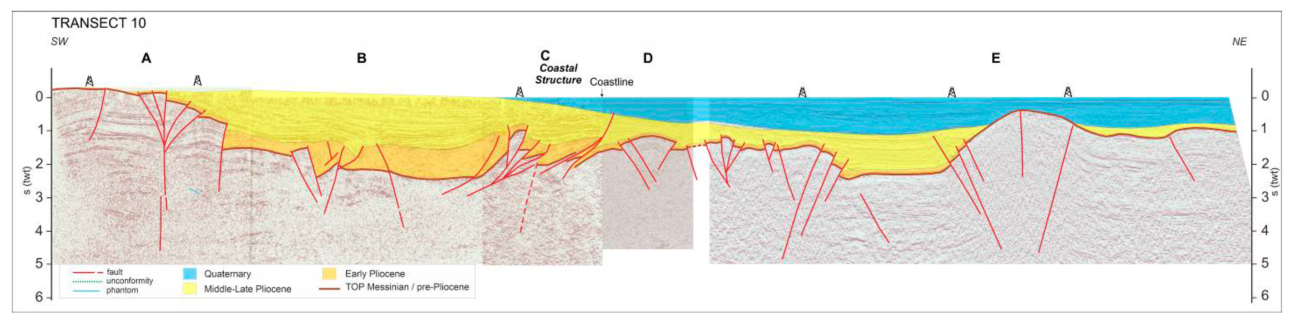
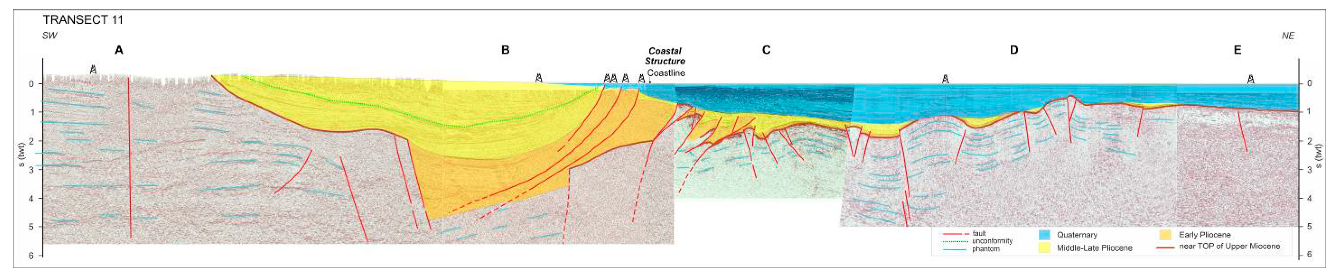
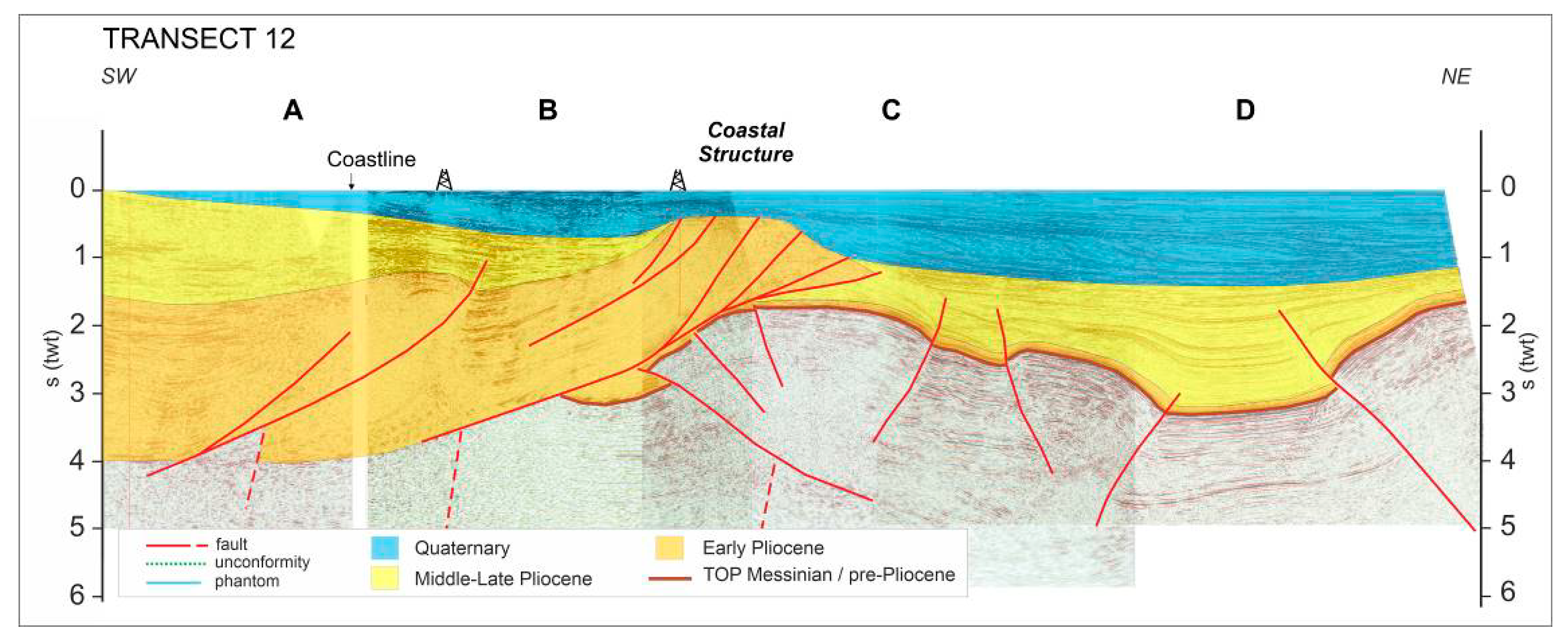
4. Results by Wells and Seismic Profiles Interpretation
4.1. Transects
4.2. Characteristics and Distribution of the Plio–Quaternary Deformation
4.2.1. Early Pliocene
4.2.2. Middle-Late Pliocene-Quaternary
5. Discussion
6. Conclusions
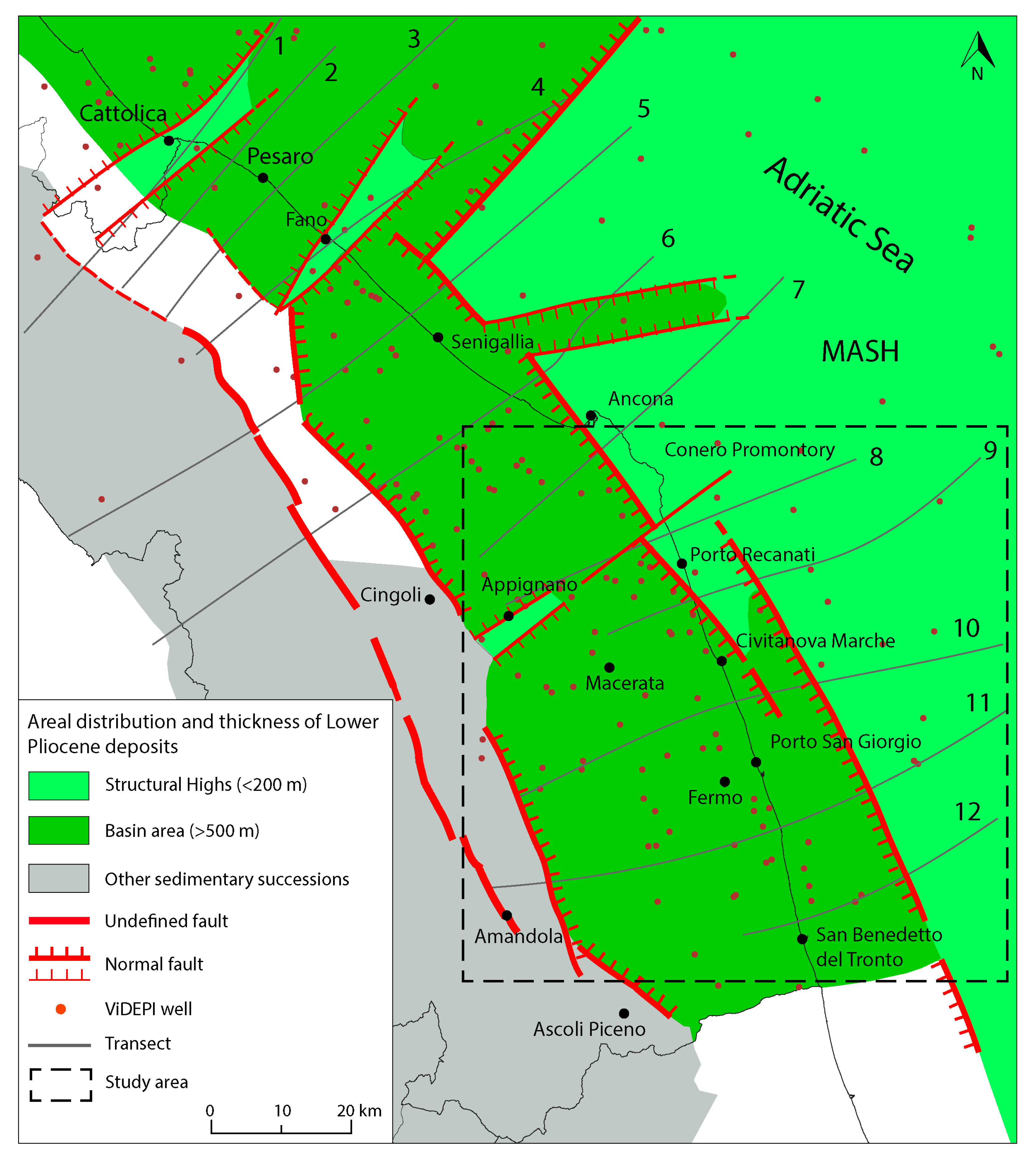
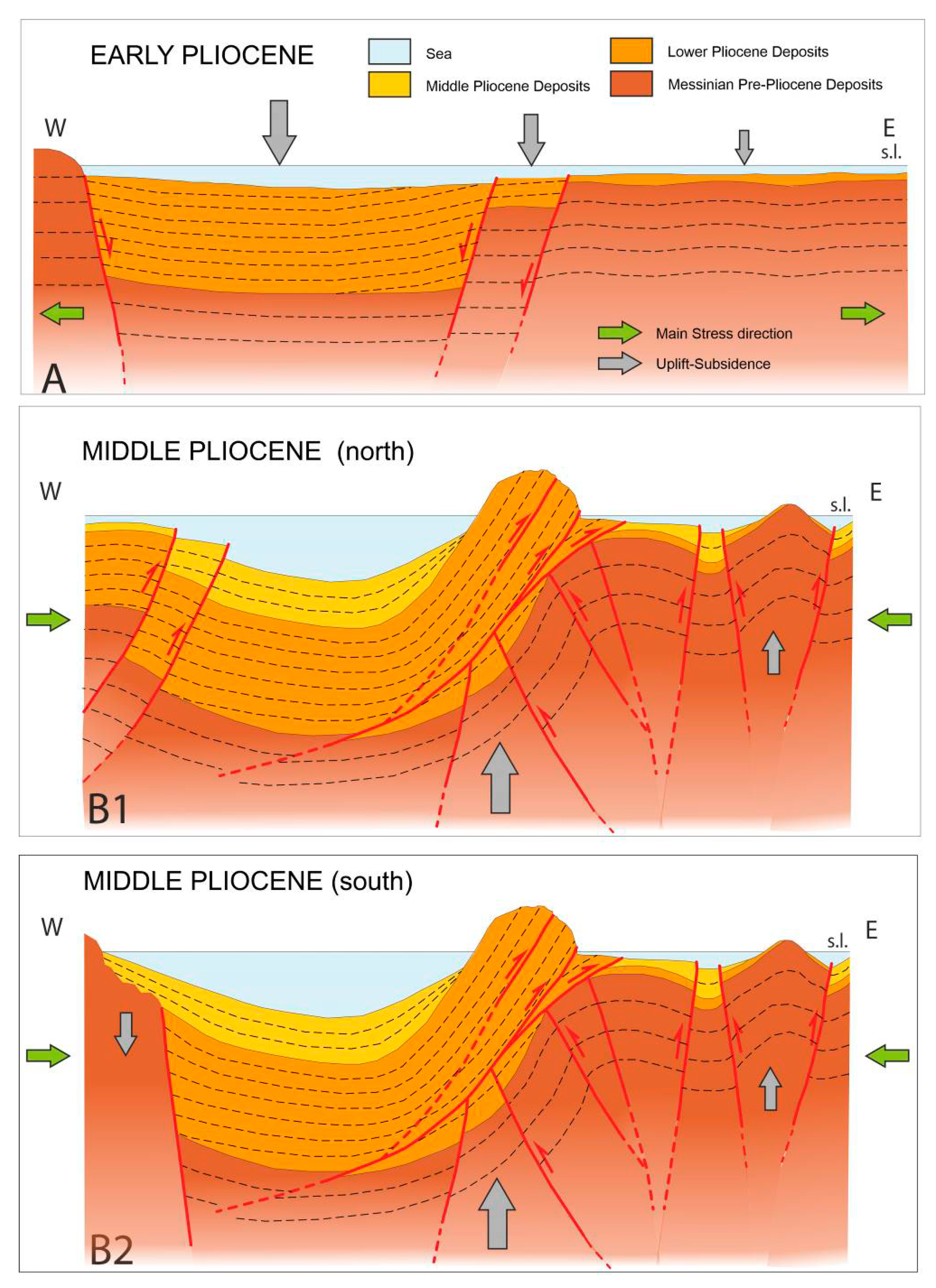
- During the Early Pliocene, the area was affected by extensional or transtensive tectonics, resulting in the formation of a strongly subsident basin and a more stable structural high. More than 3000 m of sediment accumulated in the basin zone, while the structural high (MASH) hosts less than 200 m of Lower Pliocene deposits.
- The basins and structural highs are separated by an approximately NNW–SSE normal and transtensive fault system located close to the current coastline. Other normal faults with an NNW–SSE trend developed in the current onshore area and border the basin to the W. The structural high is instead located in the current offshore area.
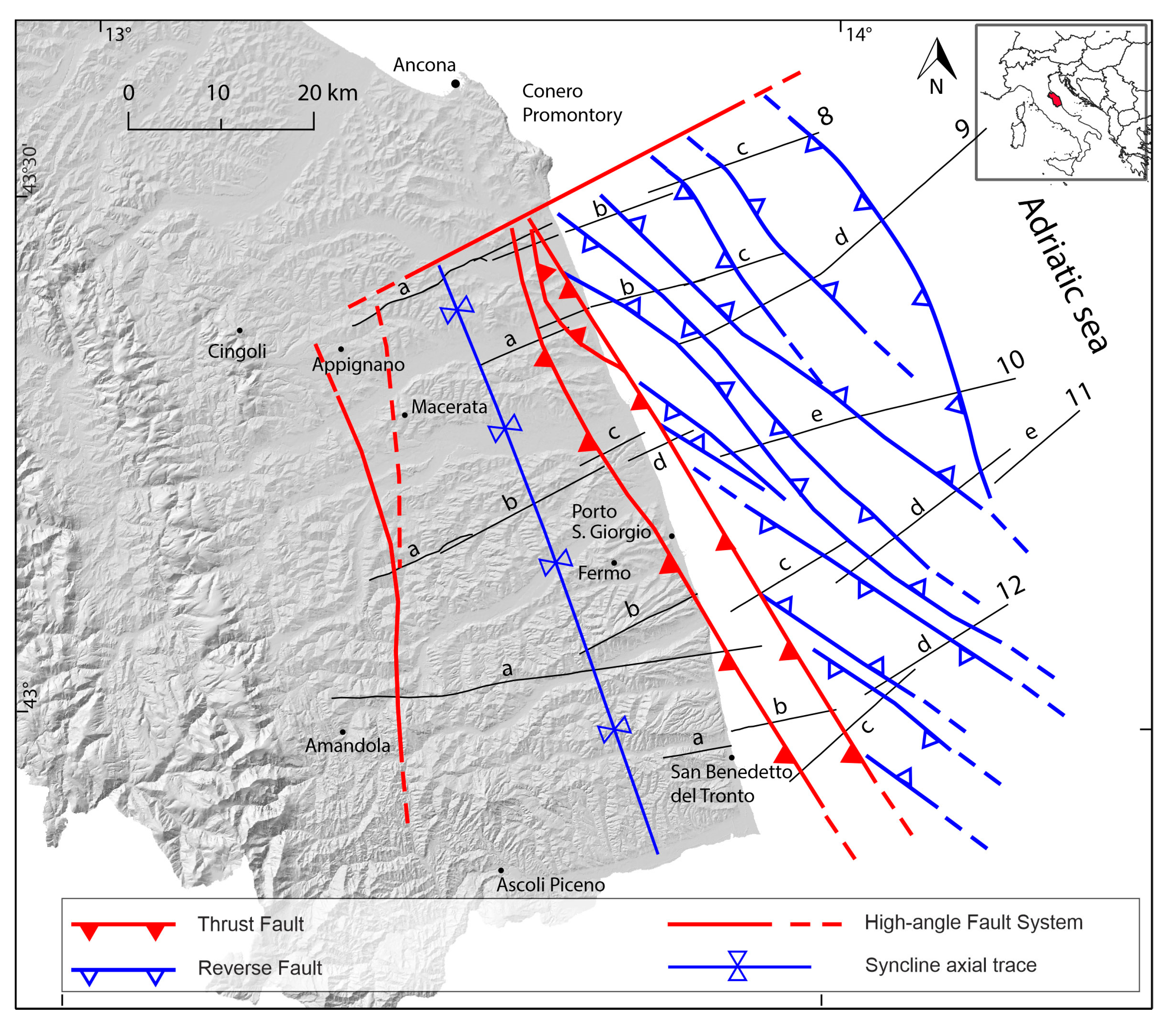
- Starting from the Middle Pliocene, the entire area underwent compression, with the P axis oriented about NNE–SSW leading the formation, from W to E, of the NNW-SSE dextral strike-slip Amandola structure, the NNW–SSE dextral transpressive Coastal Structure, and an NW–SE-striking system of gentle flower structures (offshore).
- The Coastal Structure is the most complex and important structure in the study area. It consists of an E-vergent thrust system at surface and high-angle E and W-vergent faults at depth. Shallow thrusts mainly affected the Pliocene deposits and, locally, the Quaternary ones. The mainly Messinian underlying deposits were marginally involved in deformation. Deeper faults affect Mio-Pliocene and older deposits. As a result, in the shallower part of the Coastal Structure, pre-existing normal faults were inverted or crosscut and incorporated into the ongoing thrusts, while at depth, they were not deformed.
- The trends of the Coastal Structure and the flower structures within the offshore are slightly divergent despite being contemporaneous because the former was strongly influenced by inherited structures.
- The compressive phase was finished during the Late Pliocene in the syncline, as well as along the flower structures. The Coastal Structure was still active during the Quaternary. This is also testified by recently recorded seismic activity.
- A complex transverse structure with a general ENE–WSW trend (at least partially active and seismogenic) traces the boundary between the outer areas north and south of the Conero promontory, where the styles, geometries and times of deformation of the Plio–Quaternary structures are significatively different.
Supplementary Materials
Author Contributions
Funding
Institutional Review Board Statement
Informed Consent Statement
Acknowledgments
Conflicts of Interest
References
- Boccaletti, M.; Calamita, F.; Deiana, G.; Gelati, R.; Massari, F.; Moratti, G.; Ricci-Lucchi, F. Migrating Foredeep-Thrust Belt Systems in the Northern Apennines and Southern Alps Palaeogeogr. Palaeoclimatol. Palaeoecol. 1990, 77, 3–14. [Google Scholar] [CrossRef]
- Ghielmi, M.; Minervini, M.; Nini, C. Sedimentary and Tectonic Evolution in the Eastern Po-Plain and Northern Adriatic Sea Area from Messinian. Rend. Fis. Acc. Lincei. 2010, 21, 131–166. [Google Scholar] [CrossRef]
- Turrini, C.; Toscani, G.; Lacombe, O.; Roure, F. Influence of Structural Inheritance on Foreland-Foredeep System Evolution: An Example from the Po Valley Region (Northern Italy). Mar. Pet. Geol. 2016, 77, 376–398. [Google Scholar] [CrossRef]
- Odlum, M.L.; Stockli, D.; Capaldi, T.N.; Thomson, K.D.; Clarck, J.; Puigdefàbregas, C.; Fildani, A. Tectonic and Sediment Provenance Evolution of the South Eastern Pyrenean Foreland Basins During Rift Margin Inversion and Orogenic Uplift. Tectonophysics 2019, 765, 226–248. [Google Scholar] [CrossRef]
- Bally, A.W.; Burbi, L.; Cooper, C.; Ghelardoni, R. Balanced Sections and Seismic Reflecion Profiles across the Central Apennines. Mem. Della Soc. Geol. Ital. 1986, 35, 257–310. [Google Scholar]
- Calamita, F.; Deiana, G. Evoluzione Strutturale Neogenico-Quaternaria Dell’appennino Umbro-Marchigiano. Stud. Geol. Camerti Vol. Spec. “La Geol. delle Marche” 1986, 91–98. [Google Scholar] [CrossRef]
- Centamore, E.; Pambianchi, G.; Minetti, A. Ambiente Fisico Delle Marche: Geologia Geomorfologia Idrogeologia Regione Marche, Giunta Regionale; Firenze: S.E.L.C.A.: Florence, Italy, 1991. [Google Scholar]
- Pierantoni, P.P.; Deiana, G.; Romano, A.; Paltrinieri, W.; Borraccini, F.; Mazzoli, S. Geometrie strutturali lungo la thrust zone del fronte montuoso umbro-marchigiano-sabino. Bollettino della Società geologica italiana. Bollettino della Società geologica italiana 2005, 124, 395–411. [Google Scholar]
- Amadori, C.; Toscani, G.; Di Giulio, A.; Maesano, F.E.; D’Ambrogi, C.; Ghielmi, M.; Fantoni, R. From Cylindrical to Non-Cylindrical Foreland Basin: Pliocene–Pleistocene Evolution of the Po Plain–Northern Adriatic Basin (Italy). Basin. Res. 2019, 31, 991–1015. [Google Scholar] [CrossRef] [Green Version]
- Cantalamessa, G.; Centamore, E.; Cristallini, C.; Invernizzi, C.; Matteucci, R.; Micarelli, A.; Piccini, M.; Pontoni, F.; Potetti, M. Nuovi Dati Sulla Geologia Dell’area di Porto San Giorgio (Ascoli P iceno, Marche). Geol. Rom. 1987, 26, 359–369. [Google Scholar]
- Ori, G.G.; Serafini, G.; Ricci Lucchi, F.; Casnedi, R.; Colalongo, M.L.; Mosna, S. The Plio-Pleistocene Adriatic Foredeep (Marche and Abruzzo, Italy): An Integrated Approach to Surface and Subsurface Geology. In Proceedings of the 3rd E.A.P.G. Conference, Adriatic Foredeep, Florence, Italy, 26–30 May 1991; pp. 1–86. [Google Scholar]
- Invernizzi, C. Relazioni tra Costruzione Della Catena e Migrazione Dell’avanfossa Nell’area Marchigiana Esterna: Alcune Osservazioni. Stud. Geol. Camerti 1992, 12, 71–78. [Google Scholar] [CrossRef]
- Ghielmi, M.; Minervini, M.; Nini, C.; Rogledi, S.; Rossi, M. Late Miocene-Middle Pleistocene Sequences in the Po Plain Northern Adriatic Sea (Italy): The stratigraphic Record of Modification Phases Affecting a Complex Foreland Basin. Mar. Pet. Geol. 2013, 42, 50–81. [Google Scholar] [CrossRef]
- Barchi, M.R.; Alvarez, W.; Shimabukuro, D.H. The Umbria-Marche Apennines as a Double Orogen: Observations and Hypotheses. Ital. J. Geosci. 2012, 131, 258–271. [Google Scholar] [CrossRef]
- De Donatis, M.; Invernizzi, C.; Landuzzi, A.; Mazzoli, S.; Potetti, M. CROP03: Structure of the Montecalvo in Foglia-Adriatic Sea Segment. Mem. della Soc. Geol. Ital. 1998, 52, 617–630. [Google Scholar]
- Mazzoli, S.; Pierantoni, P.P.; Borraccini, F.; Paltrinieri, W.; Deiana, G. Geometry, Segmentation Pattern and Displacement Variations Along a Major Apennine Thrust Zone, Central Italy. J. Struct. Geol. 2005, 27, 1940–1953. [Google Scholar] [CrossRef]
- Scisciani, V.; Calamita, F.; Tavarnelli, E.; Rusciadelli, G.; Ori, G.G.; Paltrinieri, W. Foreland-Dipping Normal Faults in the Inner Edges of Syn-Orogenic Basins: A Case from the Central Apennines, Italy. Tectonophysics 2001, 330, 211–224. [Google Scholar] [CrossRef]
- Scisciani, V.; Tavarnelli, E.; Calamita, F. The Interaction of Extensional and Contractional Deformations in the Outer Zones of the Central Apennines, Italy. J. Struct. Geol. 2002, 24, 1647–1658. [Google Scholar] [CrossRef]
- Scisciani, V.; Montefalcone, R. Coexistence of Thin- and Thick-Skinned Tectonics: An Example from the Central Apennines Italy. Spec. Pap. -Geol. Soc. Am. 2005, 2414, 33–54. [Google Scholar] [CrossRef]
- Mancinelli, P.; Scisciani, V. Seismic Velocity-Depth Relation in a Siliciclastic Turbiditic Foreland Basin: A Case Study from the Central Adriatic Sea. Mar. Pet. Geol. 2020, 120, 104554. [Google Scholar] [CrossRef]
- Tavarnelli, E.; Scisciani, V.; Patruno, S.; Calamita, F.; Pace, P.; Iacopini, D. The Role of Structural Inheritance in the Evolution of Fold-and-Thrust Belts: Insights from the Umbria-Marche Apennines, Italy. GSA Spec. Pap. 2019, 542. [Google Scholar] [CrossRef]
- Conti, P.; Cornamusini, G.; Carmignani, L. An Outline of the Geology of the Northern Apennines (Italy), with Geological Map at 1:250,000 Scale Ital. J. Geosci. 2020, 139, 149–194. [Google Scholar] [CrossRef]
- Pierantoni, P.P.; Deiana, G.; Galdenzi, S. Stratigraphic and Structural Features of the Sibillini Mountains (Umbria- Marche Apennines, Italy). Ital. J. Geosci. 2013, 132, 497–520. [Google Scholar] [CrossRef]
- Pierantoni, P.P.; Chicco, J.; Costa, M.; Invernizzi, C. Plio-Quaternary Transpressive Tectonics: A Key Factor in the Structural Evolution of the Outer Apennine–Adriatic System, Italy. J. Geol. Soc. Lond. 2019, 176, 1273–1283. [Google Scholar] [CrossRef]
- Chicco, J.M.; Pierantoni, P.P.; Costa, M.; Invernizzi, C. Plio-Quaternary Tectonics and Possible Implications for Geothermal Fluids in the Marche Region (Italy). Tectonophysics 2019, 755, 21–34. [Google Scholar] [CrossRef]
- Scisciani, V.; Agostini, S.; Calamita, F.; Paolo, P.; Cilli, A.; Giori, I.; Paltrinieri, W. Positive Inversion Tectonics in Foreland Fold- and-Thrust Belts: A Reappraisal of the Umbria-Marche Northern Apennines (Central Italy) by Integrating Geological and Geophysical Data. Tectoniphysics 2014, 637, 218–337. [Google Scholar] [CrossRef]
- Bigi, S.; Calamita, F.; Cello, G.; Centamore, E.; Deiana, G.; Paltrinieri, W.; Pierantoni, P.P.; Ridolfi, M. Tectonics and Sedimentation Within a Messinian Foredeep in the Central Apennines, Italy. J. Pet. Geol. 1999, 22, 5–18. [Google Scholar] [CrossRef]
- Artoni, A. The Pliocene-Pleistocene Stratigraphic and Tectonic Evolution of the Central Sector of the Western Periadriatic Basin of Italy. Mar. Pet. Geol. 2013, 42, 82–106. [Google Scholar] [CrossRef]
- Milli, S.; Moscatelli, M.; Stanzione, O.; Falcini, F. Sedimentology and Physical Stratigraphy of the Messinian Turbidite Deposits of the Laga Basin (Central Apennines, Italy). Boll. della Soc. Geol. Ital. 2007, 126, 255–281. [Google Scholar]
- Bigi, S.; Milli, S.; Corrado, S.; Casero, P.; Aldega, L.; Botti, F.; Moscatelli, M.; Stanzione, O.; Falcini, F.; Marini, M.; et al. Stratigraphy, Structural Setting and Burial History of the Messinian Laga Basin in the Context of Apennine Foreland Basin System. J. Mediterr. Earth Sci. 2009, 1, 61–84. [Google Scholar] [CrossRef]
- Bigi, S.; Casero, P.; Ciotoli, G. Seismic Interpretation of the Laga Basin; Constraints on the Structural Setting and Kinematics of the Central Apennines. J. Geol. Soc. Lond.. 2011, 168, 179–189. [Google Scholar] [CrossRef]
- Ghielmi, M.; Serafini, G.; Artoni, A.; di Celma, C.; Pitts, A. From Messinian to Pleistocene: Tectonic Evolution and Stratigraphic Architecture of the Central Adriatic Foredeep (Abruzzo and Marche, Central Italy). In Proceedings of the 34th IAS International Meeting of Sedimentology, Rome, Italy, 10–13 September 2019. [Google Scholar]
- Carminati, E.; Doglioni, C. Alps vs. Apennines: The paradigm of a Tectonically Asymmetric Earth. Earth-Sci. Rev. 2012, 112, 67–96. [Google Scholar] [CrossRef]
- Cuffaro, M.; Riguzzi, F.; Scrocca, D.; Antonioli, F.; Carminati, E.; Livani, M.; Doglioni, C. On the Geodynamics of the Northern Adriatic Plate Rend. Lincei 2010, 21, 253–279. [Google Scholar] [CrossRef]
- Deiana, G.; Pialli, G. The Structural Provinces of the Umbria-Marchean Apennines. Mem. Soc. Geol. It 1994, 48, 473–484. [Google Scholar]
- Dewey, J.F.; Helman, M.L.; Knott, S.D.M.L.; Turco, E.; Hutton, D.H.W. Kinematics of the Western Mediterranean. Geol. Soc. London Spec. Publ. 1989, 45, 265–283. [Google Scholar] [CrossRef]
- Schettino, A.; Turco, E. Plate Kinematics of the Western Mediterranean Region During the Oligocene and Early Miocene. Geophys. J. Int. 2006, 166, 1398–1423. [Google Scholar] [CrossRef] [Green Version]
- Turco, E.; Macchiavelli, C.; Mazzoli, S.; Schettino, A.; Pierantoni, P.P. Kinematic Evolution of Alpine Corsica in the Framework of Mediterranean Mountain Belts. Tectonophysics 2012, 579, 193–206. [Google Scholar] [CrossRef]
- Pierantoni, P.P.; Penza, G.; Macchiavelli, C.; Schettino, A.; Turco, E. Kinematics of the Tyrrhenian-Apennine System and Implications for the Origin of the Campanian Magmatism. In Vesuvius, Campi Flegrei, and Campanian Volcanism; De Vivo, B., Belkin, H., Rolandi, G., Eds.; Elsevier: Amsterdam, The Netherlands, 2020. [Google Scholar] [CrossRef]
- Calamita, F.; Scisciani, V.; Montefalcone, R.; Paltrinieri, W.; Pizzi, A. L’ereditarietà del Paleomargine Dell’adria Nella Geometria Del Sistema Orogenico Centro-Appenninico: L’area Abruzzese Esterna. Mem. Soc. Geol. Ital. 2002, 55, 355–368. [Google Scholar]
- Tavarnelli, E.; Butler, R.W.H.; Decandia, F.A.; Calamita, F.; Grasso, M.; Alvarez, W.; Renda, P. Implications of Fault Reactivation and Structural Inheritance in the Cenozoic Evolution of Italy. Spec. Vol. Ital. Geol. Soc. IGC 32 Florence-2004 2004, 209–222. [Google Scholar]
- Centamore, E.; Rossi, D. Neogene-Quaternary Tectonics and Sedimentation in the Central Apennines. Boll. della Soc. Geol. Ital. 2009, 128, 73–88. [Google Scholar]
- Scisciani, V. Styles of Positive Inversion Tectonics in the Central Apennines and in the Adriatic Foreland: Implications for the Evolution of the Apennine Chain (Italy). J. Struct. Geol. 2009, 31, 1276–1294. [Google Scholar] [CrossRef]
- Scisciani, V.; Patruno, S.; Tavarnelli, E.; Calamita, F.; Pace, P.; Iacopini, D. Multi-Phase Reactivations and Inversions of Paleozoic-Mesozoic Extensional Basins During the Wilson Cycle: Case Studies from the North Sea (UK) and Northern Apennines (Italy). Geol. Soc. Lond., Spec. Publ. 2019, 470, 205–243. [Google Scholar] [CrossRef]
- Bonini, L.; Basili, R.; Burrato, P.; Cannelli, V.; Fracassi, U.; Maesano, F.E.; Melini, D.; Tarabussi, G.; Tiberti, M.M.; Vannoli, P.; et al. Testing Different Tectonic Models for the Source of the Mw 6.5, 30 October 2016, Norcia Earthquake (Central Italy): A Youthful Normal Fault, or Negative Inversion of an Old Thrust? Tectonics 2019, 38, 990–1017. [Google Scholar] [CrossRef] [Green Version]
- Mazzoli, S.; Deiana, G.; Galdenzi, S.; Cello, G. Miocene Fault-Controlled Sedimentation and Thrust Propagation in the Previously Faulted External Zones of the Umbria-Marche Apennines. Stephan Mueller Spec. Publ. Ser. 2002, 1, 195–209. [Google Scholar] [CrossRef]
- Calamita, F.; Coltorti, M.; Piccinini, D.; Pierantoni, P.P.; Pizzi, A.; Ripepe, M.; Scisciani, V.; Turco, E. Quaternary Faults and Seismicity in the Umbro-Marchean Apennines (Central Italy): Evidence from the 1997 Colfiorito Earthquake. J. Geodyn. 2000, 29, 245–264. [Google Scholar] [CrossRef]
- Cello, G.; Deiana, G.; Ferelli, L.; Marchegiani, L.; Maschio, L.; Mazzoli, S.; Michetti, A.; Serva, L.; Tondi, E.; Vittori, T. Geological Constraints for Earthquake Faulting Studies in the Colfiorito Area (Central Italy). J. Seismol. 2000, 4, 357–364. [Google Scholar] [CrossRef]
- Tondi, E.; Jablonská, D.; Volatili, T.; Michele, M.; Mazzoli, S.; Pierantoni, P.P. The Campotosto Linkage Fault Zone Between the 2009 and 2016 Seismic Sequences of Central Italy: Implications for Seismic Hazard Analysis. GSA Bull. 2020, 1–16. [Google Scholar] [CrossRef]
- Carruba, S.; Casnedi, R.; Perotti, C.R.; Tornaghi, M.; Bolis, G. Tectonic and Sedimentary Evolution of the Lower Pliocene Periadriatic Foredeep in Central Italy. Int. J. Earth Sci. 2006, 95, 665–683. [Google Scholar] [CrossRef]
- Lucchi, F.R. The Oligocene to Recent Foreland Basins of the Northern Apennines. Spec. Publs. Ass. Sediment. 1986, 8, 105–139. [Google Scholar] [CrossRef]
- Cantalamessa, G.; Cantemore, E.; Chiocchini, U.; Colalongo, M.L.; Micarelli, A.; Nanni, T.; Pasini, G.; Potetti, M.; Ricci Lucchi, F.; Cristallini, C.; et al. Il Plio-Pleistocene Marchigiano-Abruzzese. Available online: http://193.204.8.201:8080/jspui/bitstream/1336/199/1/Vol.%20Geologia%20Marche%20Capitolo%205.pdf (accessed on 30 March 2021).
- Marini, M.; Milli, S.; Ravnås, R.; Moscatelli, M. A Comparative Study of Confined vs. Semi-Confined Turbidite Lobes from the Lower Messinian Laga Basin (Central Apennines, Italy): Implications for Assessment of Reservoir Architecture. Mar. Pet. Geol. 2015, 63, 142–165. [Google Scholar] [CrossRef]
- Artoni, A. Messinian Events Within the Tectono-Stratigraphic Evolution of the Southern Laga Basin (Central Apennines, Italy). Boll. della Soc. Geol. Ital. 2003, 122, 447–465. [Google Scholar]
- De Alteriis, G. Different Foreland Basins in Italy: Examples from the Central and Southern Adriatic Sea. Tectonophysics 1986, 252, 349–373. [Google Scholar] [CrossRef]
- Cantalamessa, G.; Centamore, E.; Micarelli, A.; Potetti, M. Il Miocene nelle Marche. Available online: http://193.204.8.201:8080/jspui/bitstream/1336/196/1/Vol.%20Geologia%20Marche%20Capitolo%203.pdf (accessed on 30 March 2021).
- Di Celma, C. Sedimentology, Architecture, and Depositional Evolution of a Coarse-Grained Submarine Canyon fill from the Gelasian (Early Pleistocene) of the Peri-Adriatic Basin, Offida, Central Italy. Sediment. Geol. 2011, 238, 233–253. [Google Scholar] [CrossRef]
- Di Celma, C.; Cantalamessa, G.; Didaskalou, P. Stratigraphic Organization and Predictability of Mixed Coarse-Grained and Fine-Grained Successions in an Upper Slope Pleistocene Turbidite System of the Peri-Adriatic Basin. Sedimentology 2013, 60, 763–799. [Google Scholar] [CrossRef]
- Roveri, M.; Manzi, V.; Ricci Lucchi, F.; Rogledi, S. Sedimentary and Tectonic Evolution of the Vena del Gesso Basin (Northern Apennines, Italy): Implications for the Onset of the Messinian Salinity Crisis. Bull. Geol. Soc. Am. 2003, 115, 387–405. [Google Scholar] [CrossRef]
- Bigi, S.; Conti, A.; Casero, P.; Ruggiero, L.; Recanati, R.; Lipparini, L. Geological Model of the Central Periadriatic Basin (Apennines, Italy). Mar. Pet. Geol. 2013, 42, 107–121. [Google Scholar] [CrossRef]
- Porreca, M.; Minelli, G.; Ercoli, M.; Brobia, A.; Mancinelli, P.; Cruciani, F.; Giorgetti, C.; Carboni, F.; Mirabella, F.; Cavinato, G.; et al. Seismic Reflection Profiles and Subsurface Geology of the Area Interested by the 2016–2017 Earthquake Sequence (Central Italy). Tectonics 2018, 37, 1116–1137. [Google Scholar] [CrossRef]
- Centamore, E.; Cantalamessa, G.; Micarelli, A. Stratigrafia e Analisi di Facies dei Depositi del Miocene e del Pliocene Inferiore Dell’avanfossa Marchigiano-Abruzzese e Delle Zone Limitrofe. Stud. Geol. Camerti 1991, 11, 125–131. [Google Scholar]
- Pace, P.; Scisciani, V.; Calamita, F.; Butler, R.W.H.; Iacopini, D.; Esestisme, P.; Hodgson, N. Inversion Structures in a Foreland Domain: Seismic Examples from the Italian Adriatic Sea. Interpretation 2015, 3, 161–176. [Google Scholar] [CrossRef]
- Williams, G.D.; Powell, C.M.; Cooper, M. Geometry and Kinematics of Inversion Tectonics. Geol. Soc. Lond. Spec. Publ. 1989, 44, 3–15. [Google Scholar] [CrossRef]
- Bolis, G.; Carruba, S.; Casnedi, R.; Perotti, C.R.; Ravaglia, A.; Tornaghi, M.; Tavarnelli, E.; Calamita, F.; Paltrinieri, W. Compressional Tectonics Overprinting Extensional Structures in the Abruzzo Periadriatic Foredeep (Central Italy) during Pliocene Times. Ital. J. Geosci. 2003, 122, 251–266. [Google Scholar]
- Costa, M. The Buried, Apenninic Arcs of the Po Plain and Northern Adriatic Sea (Italy): A New Model. Italian Journal of Geosciences. 2003, 122, 3–23. [Google Scholar]
- Mazzoli, S.; Santini, S.; Macchiavelli, C.; Ascione, A. Active tectonics of the outer northern Apennines Adriatic vs. Po Plain seismicity and stress fields. J. Geodyn. 2015, 84, 62–76. [Google Scholar] [CrossRef]
- Mazzoli, S.; Macchiavelli, C.; Ascione, A. The 2013 Marche Offshore Earthquakes: New Insights into the Active Tectonic Setting of the Outer Northern Apennines. J. Geol. Soc. Lond. 2014, 171, 457–460. [Google Scholar] [CrossRef] [Green Version]
- Mantovani, E.; Viti, M.; Babbucci, D.; Tamburelli, C.; Cenni, N. Possible Location of the Next Major Earthquakes in the Northern Apennines: Present Key Role of the Romagna-Marche-Umbria Wedge. Int. J. Geosci. 2017, 8, 1301–1314. [Google Scholar] [CrossRef] [Green Version]
- Mantovani, E.; Viti, M.; Babbucci, D.; Tamburelli, C.; Cenni, N. Geodynamics of the Central-Western Mediterranean Region: Plausible and Non-Plausible Driving Forces. Mar. Pet. Geol. 2020, 113, 104121. [Google Scholar] [CrossRef]
- Riguzzi, F.; Tertulliani, A.; Gasparini, C. Study of the Seismic Sequence of Porto San Giorgio (Marche)-3 July 1987. Nuovo Cim. C. 1989, 12, 453–466. [Google Scholar] [CrossRef]
- Battimelli, E.; Adinolfi, G.M.; Amoroso, O.; Capuano, P. Un Nuovo Studio Della Sequenza Sismica del 1987 di Porto San Giorgio. In Proceedings of the 37th National Conference GNGTS, Bologna, Italy 19–21 November 2018; pp. 13–15. [Google Scholar]
- Pierantoni, P.P.; Centamore, E.; Costa, M. Geological and Seismological data Review of the 2009 L’Aquila Seismic Sequence (Central Apennines, Italy): Deep Seated Seismogenic Structures and Seismic Hazard. Ital. J. Eng. Geol. Environ. 2017, 17, 5–40. [Google Scholar]


Publisher’s Note: MDPI stays neutral with regard to jurisdictional claims in published maps and institutional affiliations. |
© 2021 by the authors. Licensee MDPI, Basel, Switzerland. This article is an open access article distributed under the terms and conditions of the Creative Commons Attribution (CC BY) license (https://creativecommons.org/licenses/by/4.0/).
Share and Cite
Costa, M.; Chicco, J.; Invernizzi, C.; Teloni, S.; Pierantoni, P.P. Plio–Quaternary Structural Evolution of the Outer Sector of the Marche Apennines South of the Conero Promontory, Italy. Geosciences 2021, 11, 184. https://0-doi-org.brum.beds.ac.uk/10.3390/geosciences11050184
Costa M, Chicco J, Invernizzi C, Teloni S, Pierantoni PP. Plio–Quaternary Structural Evolution of the Outer Sector of the Marche Apennines South of the Conero Promontory, Italy. Geosciences. 2021; 11(5):184. https://0-doi-org.brum.beds.ac.uk/10.3390/geosciences11050184
Chicago/Turabian StyleCosta, Mario, Jessica Chicco, Chiara Invernizzi, Simone Teloni, and Pietro Paolo Pierantoni. 2021. "Plio–Quaternary Structural Evolution of the Outer Sector of the Marche Apennines South of the Conero Promontory, Italy" Geosciences 11, no. 5: 184. https://0-doi-org.brum.beds.ac.uk/10.3390/geosciences11050184