
SyPEAH: The WebAPP System for Protection and Education to Archaeological Heritage in the Parco Archeologico del Colosseo

Parco Archeologico del Colosseo, Piazza S.ta Maria Nova 53, 00186 Roma, Italy
Geosciences 2021, 11(6), 246; https://0-doi-org.brum.beds.ac.uk/10.3390/geosciences11060246
Submission received: 22 April 2021
/
Revised: 31 May 2021
/
Accepted: 1 June 2021
/
Published: 5 June 2021
(This article belongs to the Special Issue Remote Sensing, Geophysics and Geosciences for Cultural Heritage and Geoarchaeology)
Abstract
:Archaeological sites are affected by changes due to a natural deterioration process over time. If not prevented, this may compromise the functionality of the cultural property, and in turn become pathological and result in degradation. Monitoring through innovative technologies paves the way towards an effective planned maintenance activity and therefore preventive conservation. The monitoring project of the Parco Archeologico del Colosseo was inspired by the desire to build a system of protection and conservation at the service of sustainable exploitation. Established by Ministerial Decree 12 January 2017 in art. 3, the park is an independent cultural site of the Ministry of Culture. It includes the central area of Rome—the Roman Forum, the Palatine, the Colosseum and the Domus Aurea—and has an extension of about 77 hectares, of which about 32 are buildings. With these objectives, the Parco Archeologico del Colosseo has launched a static and dynamic monitoring project consisting of six fundamental levels of activities. The project involves the creation of a multi-parameter system of permanent control of the entire archaeological area, with the associated indicators of the level of risk, for which it is necessary the combined use of innovative technologies.
1. Introduction
WebGIS platforms are widely used in archaeology for different purposes (e.g., study, documentation, and education; for example, see SITAR, https://www.archeositarproject.it/ and TESS, http://tess.beniculturali.unipd.it/web/home/ accessed on: 4 June 2021). However, the new frontiers of digital archaeology are moving towards “managerial and instrumental” development in the search for shared methods for planned conservation. As highlighted in the last international conference, Sustainable conservation of UNESCO and other heritages sites through proactive geosciences (Luxor-Aswan, Egypt, 10–12 September 2019, in press), despite recent efforts and progress supported by the development of IT and ICT, aimed at the protection of cultural heritage worldwide, in the last decades many cultural heritage sites of exceptional value have suffered damage, sometimes irreversible, due to natural processes, including climate change, or human-induced, with rapid or slow onset. This is why it is crucial to anticipate, plan for and reduce the risk of heritage asset loss in order to more effectively protect cultural heritage and thus strengthen its resilience. From this awareness comes the urgent need to rethink management and conservation plans for archaeological sites in order to innovate not only from a technological point of view but also in management practices.
In line with the objectives of the UN 2030 Agenda for Sustainable Development (September 2015), in particular point 11.4 “Initiatives to strengthen the protection and safeguarding of cultural and natural heritage” [1], new ways therefore are tested to reduce the gap between the conservation approach aimed at safeguarding and the sustainable development models of the territories, placing archaeological sites in analogy with the more general theme of landscape. In the face of soil erosion, climate change and global warming effects, sustainable management is only possible if the productive potential of natural terrestrial and human capital is preserved. This is why it is necessary to reinforce the concept of land protection and cultural heritage, which is particularly complex with regard to archaeological assets due to their characteristics of interaction with the environmental matrices water, air, and soil.
With the aim of a comparison on the effects of climate change and to capitalize as much as possible on existing experiences, in 2019 the international study conference “Monitoring and maintenance of archaeological areas” [2] was organized in Rome, at Curia Iulia. The conference showed the intense commitment of institutions active in the experimentation of new conservation methodologies for reducing vulnerability and increasing resilience of cultural heritage, with particular reference to archaeological heritage. This conference happened in the same year as the already mentioned international conference Sustainable conservation of UNESCO and other heritages sites through proactive geosciences. The comparison on a planetary scale showed that the problem of heritage conservation and the effects of climate change are global (Figure 1). One example is the case of Sana’a, a city in Yemen, a UNESCO site since 1986, where torrential rains in July-August 2020 dissolved some houses built of mud dating back to the 11th century AD [3].
On the basis of these reflections, an attempt was made in the Parco archeologico del Colosseo, Rome, Italy (hereinafter Parco), to develop a management system capable of grasping and simplifying the complexity of incorporating the stratification of conservation issues and the needs of today’s society, addressing and mitigating the effects of climate change, but also capable of becoming a tool of knowledge in a process of participatory democratisation of culture.
The System for Protection and Education to Archaeological Heritage, namely SyPEAH, is a responsive WebAPP system based on open-source software. It was developed in the framework of the project of monitoring and maintenance of the Parco as a preliminary tool for an effective activity of programmed conservation of cultural heritage with particular regard to the archaeological structures. With the aim of identifying a method for assessing the risk of loss of each heritage asset, methodologies have been studied and developed to meet the needs of preventive conservation, which are currently being tested. Based on ICT, such as remote sensing, and aiming at inter/transdisciplinarity for a better management of the cultural and natural heritage, SyPEAH follows the footsteps of computer applications that have been developed for years in the field of digital archaeology [5], with some new elements.
Furthermore, SyPEAH considers the very nature of archaeological heritage. Such heritage cannot be classified within unambiguous parameters due to its own peculiarities, which involve different materials, construction techniques, historical events, restorations, and environmental context. The condition that makes each monument unique, that makes it a ruin, according to Cesare Brandi’s definition [6], is precisely the condition of conservation. This very nature has not so far made it possible to identify a solution or a general protocol that can be applied in a systematic way to counteract degradation or instability, which, urged on by the effects of climate change, become risk factors and increase vulnerability. In addition to the obvious consequences of catastrophic events, which have an immediate outcome, the question arises as to the interactive dynamics that can be triggered on monuments in a state of ruin, how they may evolve and with what coefficient of acceleration.
Even the simple variation of meteorological statistical indices has an influence on the management of an archaeological area, since it is able to trigger, as the most recent data show, significant changes in the evolutionary dynamics of weeds outside their distribution range and with a tendency to create mono-specificities which endanger the survival of the native species. In practice, for example in the Roman area, it has become apparent that the management parameters which were effective in controlling weeds in the last twenty years are now inadequate. While temperature was once considered the only factor to be controlled in order to influence germination, nowadays rainfall or atmospheric humidity and the persistence of high temperatures must also be considered.
If, therefore, on the one hand conservation has to deal with issues induced by calamitous phenomena such as those that led to the 2015 MiBACT directive on “Procedures for the management of activities to secure and safeguard the cultural heritage in the event of emergencies arising from natural disasters” [7], although natural disaster is understood as “any event arising from exogenous actions (rain, snow, temperature changes, wind, temperature excursions, floods, landslides) or endogenous actions (earthquake, volcanic eruptions) that induce extraordinary effects, in terms of extension or magnitude of the damage”, on the other hand it must now also develop shared strategies for the mitigation of the effects of climate change in the management plans of the cultural heritage, as highlighted in the Directorate Decree of the MATTM of 2015 on the “National strategy for adaptation to climate change” [8,9]. This document already identifies the main actions to be taken against this problem, such as: dissemination of knowledge, continuous monitoring, routine maintenance, assessment of priorities in relation to the state of conservation of artefacts, assessment of priorities in response to climate change, collection of data to support decision-making at national and regional level, and understanding the environmental, economic and social context of cultural heritage. Actions include continuous monitoring and planned conservation interventions in line with the provisions of the Code of Cultural Heritage and Landscape (Legislative Decree 42/2004), which defines preventive protection in article 29.4 as “the set of activities designed to limit risk situations related to the cultural heritage in its context”. With the same objectives in mind, in the 1990s the Institute for Conservation and Restoration (IsCR) launched the Risk Map. The principle underlying the standard, which links the property to the context from which the risks originate, is that preventive interventions are less impactful as they limit the need for physical action on the property or at least reduce its extent. Therefore, it is a matter of bringing the activities aimed at conservation to a management approach, in which planned maintenance applied to archaeological structures does not mean “repetitive and replacement practices” such as those implemented in the industrial and construction sectors from which the phrase is borrowed [10]. In fact, the same article 29, paragraph 1, clarifies that “conservation is achieved through a coherent, coordinated and programmed activity of study, prevention, maintenance and restoration”. Therefore, planned maintenance in this context means the conservation procedures implemented cyclically in relation to the onset of the phenomena of degradation or instability that require them, i.e., “the art of preventive restoration, as protection, remotion of dangers, assurance of favourable conditions” based on the investigation “carried out on the state of consistency of the matter and then on the environmental conditions, as they allow, make precarious, or directly threaten, the conservation” [6]. Conservation understood in this way can be understood as being closely linked to monitoring. Given that multifactorality, as already highlighted, determines the main difficulty for the implementation of planned maintenance, the possible solution lies in the identification of a procedure that allows the application of sustainable management, capable of intervening on archaeological assets by preventing emergency situations, ensuring an early warning system through mitigation strategies, as well as establishing an operational protocol to decrease vulnerability or mitigate the risk of loss, while respecting the uniqueness inherent in archaeological monuments. This objective has been pursued with SyPEAH, also taking into account the effects of climate change.
The following sections describe the architecture of SyPEAH, the data that have been used for the diagnosis of conservation issues in the Parco and the main results that have been achieved and can inform future implementation in similar archaeological contexts.
2. Materials and Methods
SyPEAH, not open to the public, covers the entire extent of the Parco. The site, established by Ministerial Decree 12 January 2017 in art.3, is an autonomous place of culture of the Ministry of Culture. It includes the central area of Rome, with the Roman Forum, the Palatine, the Colosseum and the Domus Aurea and has an extension of about 77 hectares, of which about 32 are buildings. After assessing the specific management needs of the archaeological area, and bearing in mind that the main objective is to provide effective support for planned maintenance, understood, as mentioned above, as a set of preventive restoration activities, the software architecture was structured on different levels, i.e., database, operating logic (algorithms for application logic and maintenance) and Decision Support System (DSS) based on Machine Learning (ML) algorithms.
Based on the awareness that the conservation objectives cannot longer be met by traditional GIS systems used in archaeology, which do not address monitoring and management at the same time as using satellite data, SyPEAH was developed. Based on monitoring, it aims to create a predictive model of the risk of loss of the archaeological asset and preventive conservation through planned maintenance, implemented using interferometric techniques of observation from space. By means of specially developed algorithms, the system is aimed at elaborating a qualitative and quantitative assessment of the vulnerability of the archaeological asset and thus to conduct a verification of the risk of loss of the asset itself. The aim is to intervene on the archaeological asset before the phenomenon can negatively affect it. In particular, through the implementation of a DSS, realized in one of the technologies currently considered effective and working in the scientific literature of the sector based on neural networks and ML techniques, the system is able to manage the information present on the platform, namely: satellite data, images, IoT data, scheduling data, etc. The structure of this data is engineered to have a very specific pattern that is directly linked to the ML process under development and that will support the decision-making phase of the management of maintenance activities, including the generation and correlation of schedules of the necessary interventions, so as to ensure sustainable management of the archaeological area and ensure the protection in its many aspects.
The SyPEAH multi-parameter monitoring system is therefore based on six fundamental levels or activities (Figure 2):
- −
- Indexing of historical monument data;
- −
- Processing of satellite data in order to monitor any changes in land cover;
- −
- Georeferencing of geological data;
- −
- Centralisation of in situ instrumental monitoring, including the application of experimental sensors;
- −
- Autopsy monitoring, among which weed monitoring is fundamental; also thanks to the use of specific apps that make use of Augmented Reality (AR), which, as explained below, can help to recognise structures or even weeds without being specialists;
- −
- Implementation of data in HBIM (Heritage/Historical Building Information Modeling) for the management of any information flow related to monuments in a state of ruin, including construction sites.
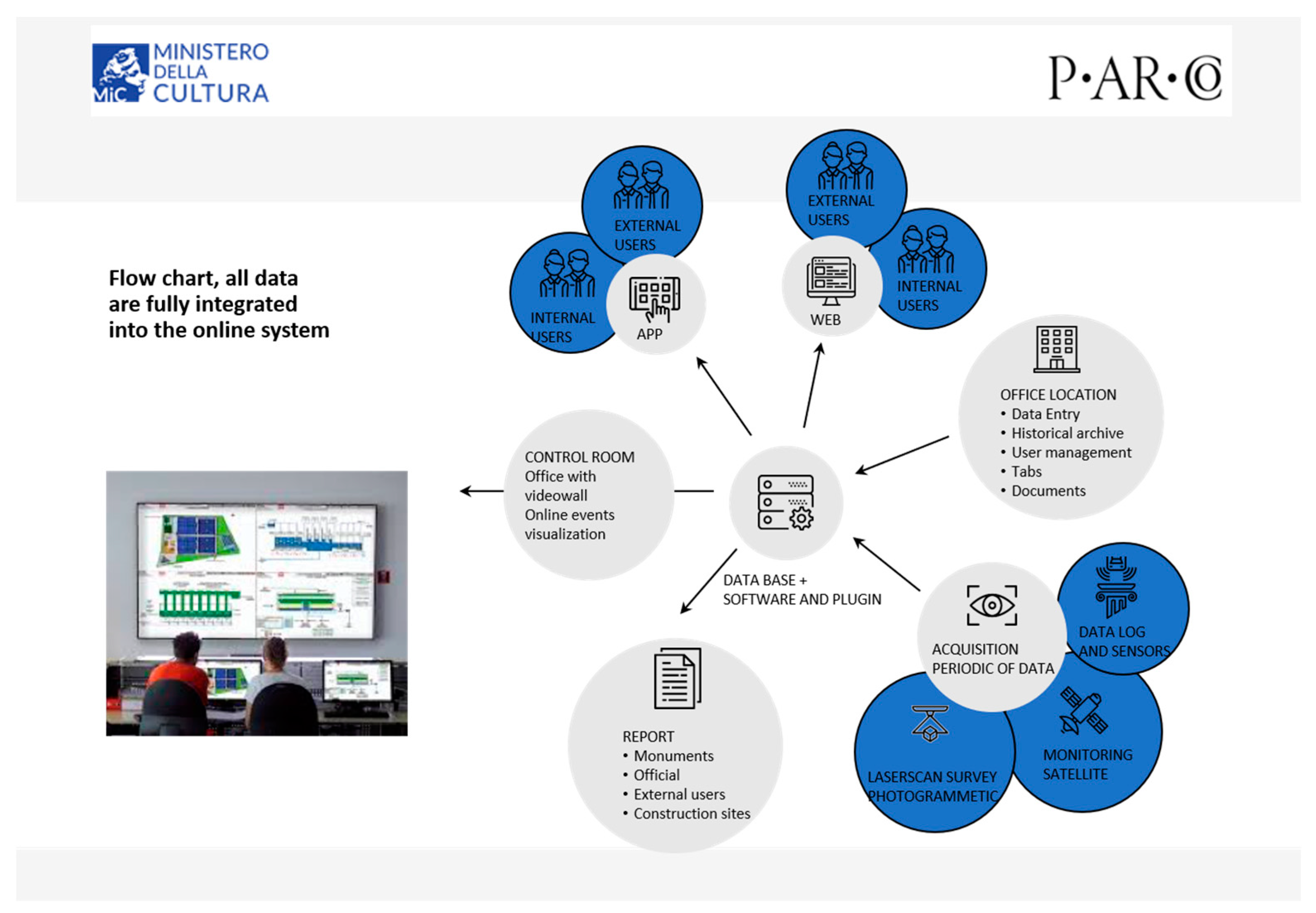
The WebAPP platform is equipped with software capable of integrating terrestrial and satellite measurement systems with analysis methods for the simultaneous processing of different data and ICT, AI, IoT and Earth observation technologies aimed at the safeguarding and structural safety of the cultural heritage. In this way, it constitutes an intuitive and easy-to-use archaeological heritage management tool that reports to the monitoring laboratory established in the archaeological park and equipped with a computer centre specifically designed and dedicated for this purpose (Figure 3).
It should be noted that SyPEAH, fully implemented in every part described below and online, is currently in the testing phase. As far as the DSS is concerned, it is in the design phase, which also depends on the data produced by the system whose population will be implemented after the conclusion of the testing.
2.1. Database
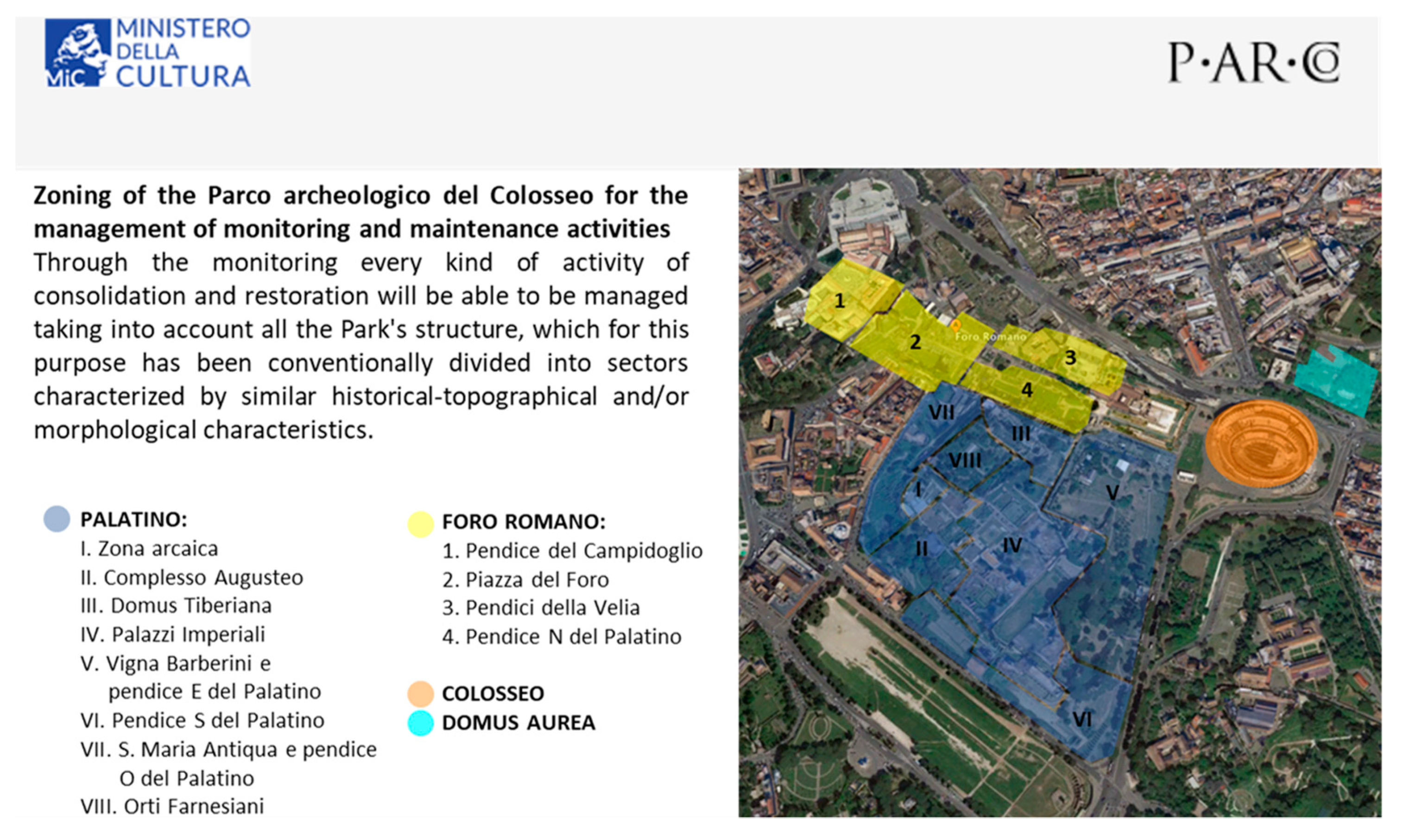
The area covered by the system was subdivided into sectors (Figure 4) and each single monument was coded, according to an alphabetical method that would allow further numerical subdivisions, in order to facilitate its identification and the interrelation of information.
Sheets were then drawn up to provide the essential and fundamental information for the intended purpose. This was undoubtedly one of the longest gestation phases due to the need to create a simple, intuitive and therefore easy-to-use working tool that would also meet the primary objective. Taking into account the ICCD’s standard schedules, but also the structure of the sheets attached to the MiBACT 2015 Directive mentioned above [7], the items considered fundamental for knowledge of the monument for preventive maintenance were identified, i.e., what it is really important to know about a structure in a state of ruin in order to be able to conserve it and therefore also what information is important for understanding the level of risk of loss of the asset itself. While the objective pursued was clear from the outset and the use of ITC, AI, IoT and Earth observation technologies immediately appeared to be a necessary and very valid tool, it was more complex to define the model to be applied to determine prevention actions and to define vulnerability in relation to risk factors and interactions with the effects of climate change.
Once the necessary data and useful information, as well as general information, had been identified, the system was divided into historical-archaeological sheets, preceded by a brief description of an administrative nature, identifying the monument: object; geographical-administrative location; cadastral location; georeferencing; legal status and constraints; and compilation. These files contain general information on the chronology of the monument, any different construction phases, any ancient or modern restorations carried out on the monument, spoliations and reuses, and past and/or current research activities. At present, the filing of historical information on the monuments is underway, based on archival research, the main objective of which is to identify all the events that are useful for reconstructing the history of the monument, taking into account diagnostic and archaeological investigations, restoration work carried out over time, etc.
These files, which relate to the monument as a whole, are linked to the files of the individual components and the expeditious files.
They are linked to the scheduling models drawn up for each monument, which represent:
- −
- the structural data: this identifies the general technical information of the monument, the characteristics of the soil and subsoil and the specifications of the structural elements; the structure is broken down into macro-structural elements in line with the UNI 8290 standard; each sub-item identifies a macro-element whose typological definition, position on the plan, description of the used materials and construction techniques and main dimensions are indicated, so as to determine the maximum size of the same; other information concerns the inspectability of the structural element, its exposure to atmospheric agents; all the information is functional to specify the actions and loads acting and, where possible, following detailed sampling and investigations, the mechanical characteristics of the element; once these specifications have been defined, finally, the possible collapse mechanisms are identified;
- −
- the state of preservation: identify the state of preservation, the static instabilities and the state of chemical-physical degradation so as to be able to give an overall picture of the state of preservation;
- −
- the geological characteristics of the site: the geological nature of the terrain on which the archaeological monuments rest may influence their evolution in terms of subsidence and structural damage; for example, in the case of lithoid rocks, fracturing and its entity may condition the evolution of what is on the surface, as well as any cavities in the subsoil, unlined or with damage to the lining;
- −
- the weed vegetation: they accompany the relevant thematic map.
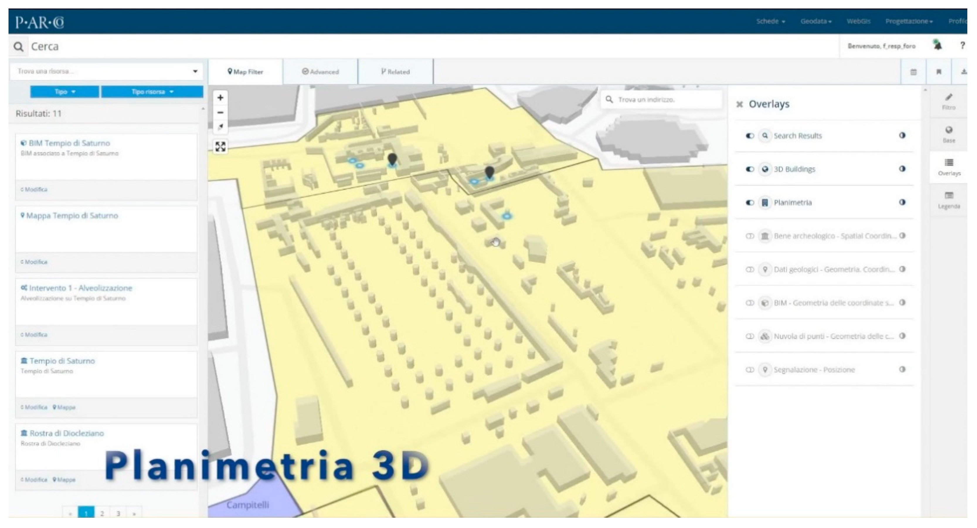
In addition to these, there is a construction site information sheet showing the work in progress, which allows for controlled management of the maintenance work. Each piece of information is interrelated and interfaced with basic cartography consisting of an archaeological map that can also be viewed in 3D for more intuitive management of the information (Figure 5).
With regard to the reference cartography, a multilayer organisation has been devised to relate the data collected on different thematic maps. One of the most important of these is the geological map of the archaeological area, which is currently being completed, accompanied by summaries of the geological investigations and prospecting that have been carried out to date and which brings together all the information relating to this aspect, including that deriving from geognostic investigations, cores and soundings carried out in the past.
In addition, a vegetation map is at an advanced stage of preparation, with a list of weed species, which are essential for evaluating the Index of Species Hazard in relation to Materials (IP/M) on which the vegetation occurs, one of the new elements of the monitoring project, which is a further parameter, in addition to the well-known Index of Species Hazard (IP) [11], for evaluating the degree of negative interaction between plant species and the materials to be protected, such as tuff, brick, concrete, marble, etc. The IP/M is given by the sum of the numerical indices that determine the IP value + the M value: this makes it possible to identify a degree of dangerousness of the weed species in relation to the different materials associated with other aspects, including sunlight, humidity, etc. and to establish intervention times based on the resistance of the different materials to the degrading action of the vegetation, as well as the most suitable method for eliminating the weeds without any collateral damage to the asset. Especially because of the resulting biological control activities, but also because of the maintenance of historical greenery, which is very important in a context such as an archaeological area, the project deemed it necessary to “revise” the danger index of weeds in relation to archaeological monuments, the IP/M.
As far as surveys obtained by means of 3D Terrestrial Laser Scanner (TLS) methodology are concerned, each overall point cloud of the surveyed object, georeferenced and connected to the Parco’s Official Topographic Reference Network, may be integrated with different instruments (GNSS satellite survey systems and Total Stations). The data coming from GNSS satellite survey systems and Total Stations or similar and 3D Laser Scanner—TLS shall converge in a single software environment for the determination of a complex and dynamically manageable georeferenced database. The point clouds will be published in the system with consultation, measurement and annotation functions. As far as photographic documentation is concerned, files containing EXIF (unmodified) and IPTC data (title and file name, description, keywords) as well as GPS coordinates shall be managed. The documentation from the ground will be combined with data from orthophotos of the area and drone scanning surveys in order to systematically verify the condition of the monuments from above using very high resolution images and to monitor the conservation and restoration work in progress and to complete the 3D surveys of the monuments. Photogrammetry and laser scanning can be integrated for general reconstruction and for the most complex architectural details.
These constitute the different layers on which the Permanent Scatterers (PS) can be superimposed (Figure 6). PS are pointwise measurement points corresponding to objects on the ground (i.e., buildings, archaeological ruins, columns, scattered architectural elements [12]) that are extracted from interferometric processing of long time series of Syntethic Aperture Radar (SAR) images collected from space and provide information on deformation processes over time. As such, the PS layer is essential to investigating the structural stability of the archaeological monuments of the Parco and warning about potential conservation issues. The technique has been successfully tested over Rome in past years [13] and is increasingly used in UNESCO sites [14]. PS included in SyPEAH were produced from the European Space Agency (ESA)’s high-resolution Sentinel-1 constellation and very high-resolution Italian Space Agency (ASI)’s COSMO-SkyMed satellites [15,16].
The study of Sentinel-1 satellite data is part of the national plan for a “multi-system monitoring system for the national archaeological and monumental heritage”, of which the Parco is the leader. The plan, which is of common strategic interest with the State Archaeological Parks, stems from the Copernicus project, a satellite Earth observation programme launched in 1998 by the European Commission and a pool of space agencies. It is currently in the design phase.
The observation of the health of the planet at a large scale specifically allows for the monitoring of soil movements, pollutants in the atmosphere, changes in climate and associated meteorological phenomena, which, if appropriately integrated with the information collected in situ, are able to contribute to the definition of the vulnerability of sites and the analysis of the risks to which cultural heritage, and in particular archaeological heritage, is exposed. The use of Earth observation techniques, in particular through COSMO-SkyMed satellites, applied to cultural heritage has now a consolidated tradition and a wide literature [16,17]. The main advantage of applying satellite analysis is the possibility of interpreting ground deformation data by reprocessing them on a monthly basis. This technique was also used in other archaeological sites, such as Pompeii; there, the catalogue of past instability phenomena was used to test how much and how the satellite interferometric monitoring technique is able to identify possible pre-collapse deformation trends for predictive purposes, useful for the identification of alert thresholds. Initial results have shown the potential of this satellite technique, especially with regard to monitoring the stability of the roofs present in the archaeological area and the effectiveness of the shoring of the wall structures [18].
2.2. Sensors
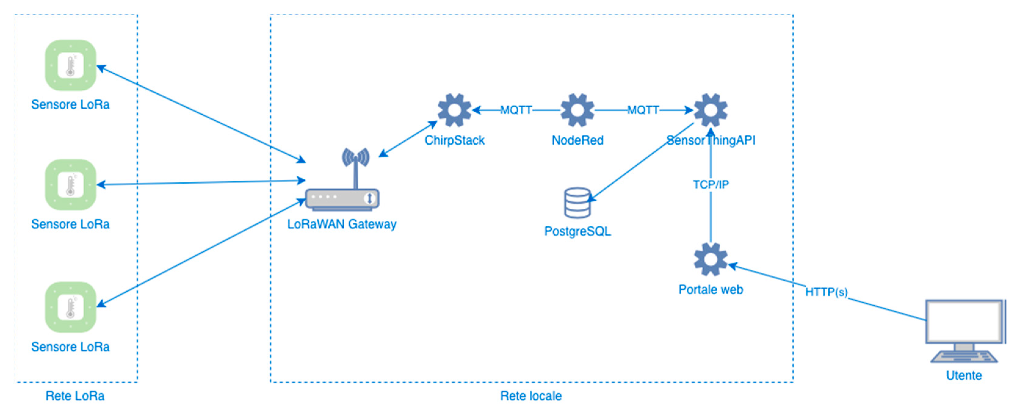
The architecture of the system of data collection from sensors (Figure 7) is composed of instruments able to transmit measurements through an ad hoc LoRaWAN network with LoRaWAN gateways able to interact with the software systems on one side and with the sensors on the other, generating notifications on the messages sent by the latter.
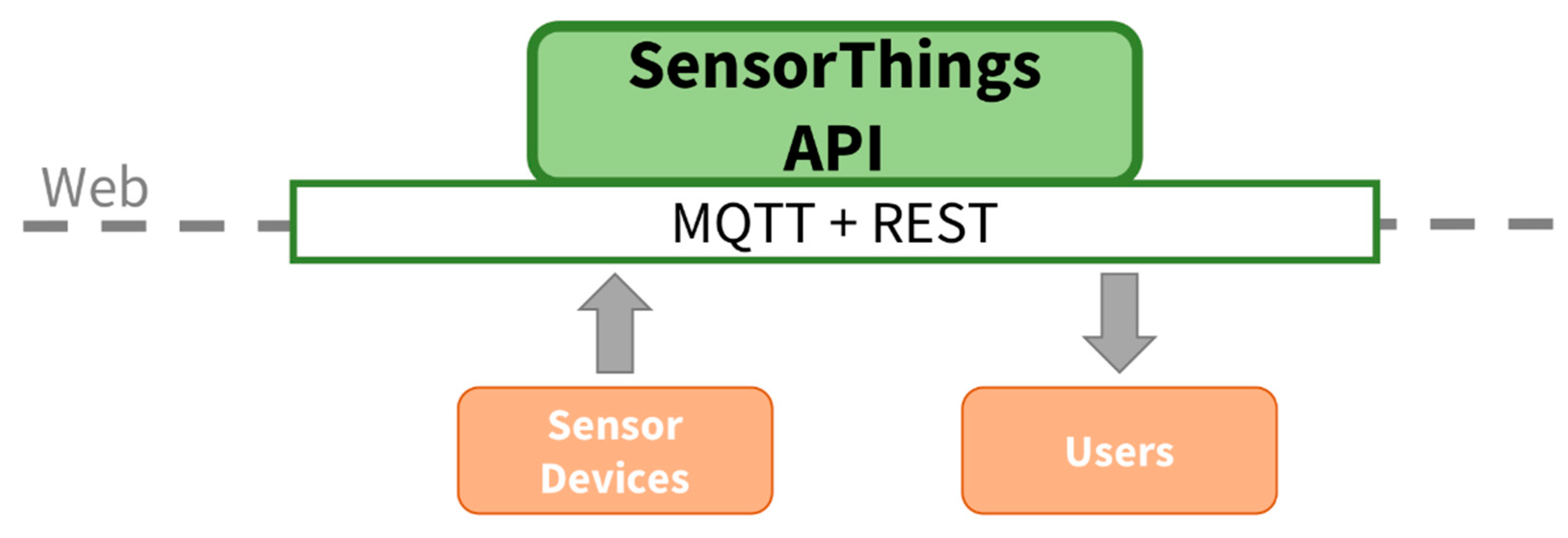
This is managed using open source software: ChirpStack, able to interact with the LoRaWAN gateway within the LoRa network; NodeRed, able to properly manage the sensor messages, converting them into the open format of the OGC (Open Geospatial Consortium) Sensor Things API (Application Programming Interface) standard; SensorThingsAPI (STA), able to store and distribute to the client the measurements generated by the sensors; PostgreSQL, database management system able to store the measurements of the sensors managed by STA; and the web portal interacts via http with STA to display the sensor measurements in a graphical interface via browser. The STA protocol is an open OGC standard for interconnecting devices, data and IoT applications over the web. It provides an MQTT (Message Queuing Telemetry Transport) extension for publish/subscribe models. NodeRed contains many types of pre-installed nodes for parsing text, executing commands, sending and receiving http/UDP/TCP/MQTT (http/Used Data Protocol/Transmission Control Protocol/MQTT) requests, accommodating and cancelling messages, processing CSV files, HTML, JSON and XML messages. Relational and non-relational databases can of course be integrated and used. These protocols are open, expandable and based on the IP communication protocol. Using STA and NodeRed software, the system is configured to interact with any sensor network and to be used with the 5G protocol (Figure 8).
3. Results
3.1. PS-Based Structural Assessment
Previous literature [19] has demonstrated the level of accuracy that InSAR can provide, especially on Z (elevation) of archaeological structure. The demonstration in Tapete et al. (2015) was with 8-m C-band SAR data and relied on ground-truth and independent measurement validation in Rome. Therefore, even higher accuracy can be achieved with X-band higher resolution (3-m), as proved by the abundant literature on the topic e.g., [20].
At the Parco, after a brief experience in the central archaeological area of Rome in 2009–2011 [12], a new satellite survey campaign has been carried out [21,22], with the advantage of using archives of radar images that allow the deduction of, in an exhaustive way, the temporal evolution of deformation processes over more than twenty years. The outcome of this campaign, which led to the acquisition of many PS, is still being studied (Figure 6). The satellite data processed in total returned:
2010–2018 period: 226,417 PS ascending analysis; 2011–2018 period: 273,461 PS descending analysis; 2010–2018 period: 9536 PS East West and vertical analysis; 2016–2019 period: 366,640 PS ascending analysis; 2016–2019 period: 299. 593 DPs descending; period 2016–2019: 25,512 DPs East West and vertical analysis; period 2010–2019: 10,868 DPs ascending analysis; period 2011–2019: 11,239 DPs descending analysis; and period 2010–2019: 1213 DPs East West and vertical analysis.
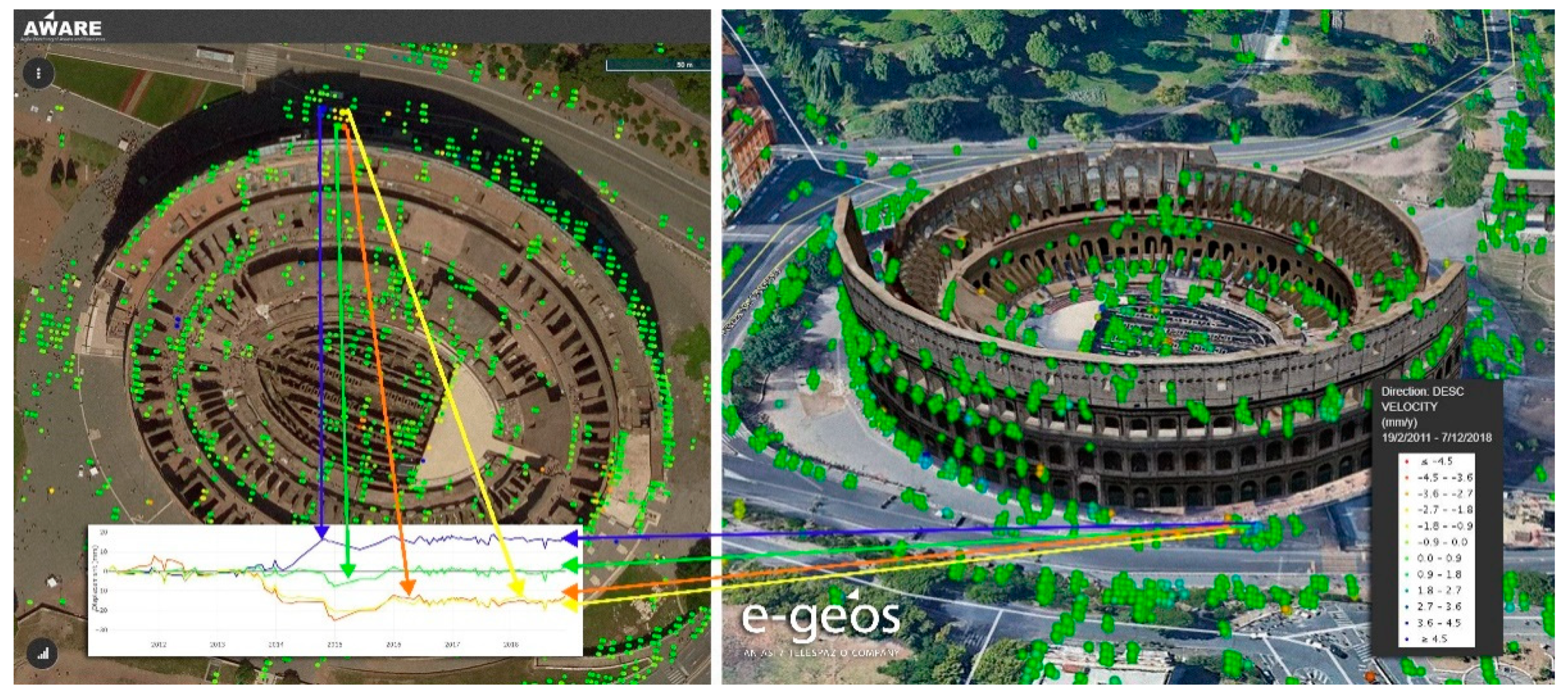
Despite the well-established application of this technique on cultural heritage, the full scope of satellite data for monument conservation and maintenance activities in this context is not yet defined. For this reason, in order to evaluate the role of satellite data within the WebAPP system and to identify a protocol for their use (whether they are the result of monitoring or historical analysis) on archaeological assets in the context of conservation and protection, an experiment was launched with the precise aim of verifying, through the use of diagnostic instrumentation, any anomalies highlighted by PS and understanding their causes and effects: the Flavian Amphitheatre was chosen as the research area, whose geometric and material characteristics make it particularly suitable for monitoring with InSAR technologies, especially through high-resolution images such as those acquired by the X-band sensors of the COSMO-SkyMed constellation (Figure 9).
The outcome of the experimentation was the development of a system for the ground validation of the satellite data, but also the type of instrumentation most suitable for this purpose, so as to be able to define a protocol that can be replicated, at least in some aspects, on a larger scale, facilitating the subsequent activities planned within the monitoring project. Given the complexity of the monument, the scope of the experiment was limited to the south side. The PS examined in this area show a general absence of displacement for the structure. About 95% of the measurement points show displacement values that cannot be detected with the analysis technique used. A very limited number of points, in isolated portions of the monument, show non-negligible displacement values that were the subject of specific observations and comparison, where possible, with other available monitoring data. These anomalies are mainly characterised by single measurement points. The absence of real clusters in motion suggests the possibility that the signal may be ascribable to extremely localised phenomena, also conditioned by the physical characteristics of the targets and by the non-structural elements present in the scenario under investigation (e.g., metal elements, balustrades, protective nets, elements of construction sites, etc.). In the time series, there do not seem to be any long-term deformation trends, which would represent the most easily detectable clues by the technique, but rather sudden displacement variations in concentrated time intervals. The elaborated project therefore deploys an instrumental network to monitor the parameters considered most significant and able to validate the satellite data, distributed on three levels, at progressively higher altitudes, not necessarily representing the architectural subdivision of the monument. The system is bipartite, being composed of two main elements: structural monitoring and environmental monitoring. The most complex part of the project was the identification of the parameters to be monitored, which can be summarised as follows:
- −
- vertical movements of the structure (e.g., subsidence), inferred from topographic levelling at the bases of the wall elements;
- −
- variations in the level of the water table, measured by means of a piezometer to be installed in one of the holes already made in the underground area;
- −
- variations in the opening of the cracks, thanks to joint gauges to be installed in sectors identified through inspection activities;
- −
- variations in the inclination of the walls, through the installation of biaxial clinometers in the walls, especially in the most potentially vulnerable sectors;
- −
- vibrations, detected through triaxial accelerometers;
- −
- weather and climate parameters (temperature, precipitation, wind), by means of thermometers, anemometers and a rain gauge.
According to the model developed, the monitoring data (output) archived at the remote control centre will be transferred to the WebAPP system through the usual transfer protocols (FTP), according to standard non-proprietary and in any case compatible formats (e.g., .json, .csv, .xml, etc.) so that they can be viewed and interrelated with the other information already present. In the same way, all the diagnostic instruments that will be installed in the future in the entire archaeological area will be managed by the system.
3.2. Sensors Census
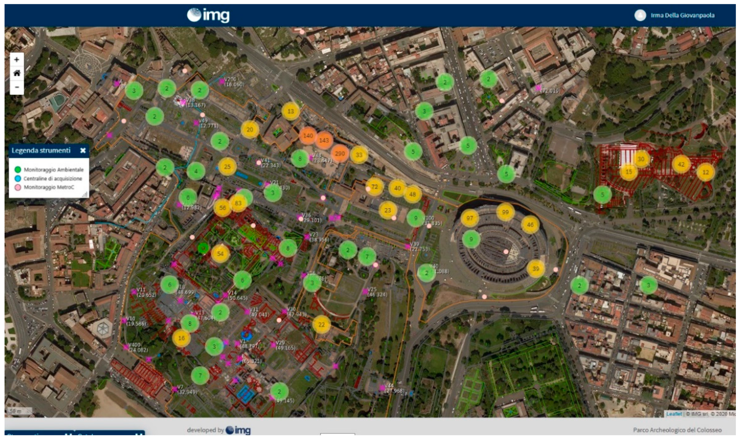
A census of all the measuring instruments present in the area was carried out prior to the design of the diagnostic instrumentation to be installed, which is currently underway. The outcome of this census was the elaboration of monographic data sheets for each individual device (from the most ‘ancient’ rods to the most modern electrical sensors), indicating their nature, function and position, which can be found in a responsive plan of the archaeological area (Figure 10).
This is a very useful working tool that also makes it possible to grasp the protection “intentions” implemented in the past and of which memory has often been lost (in fact, sometimes the devices are no longer active), thus making it possible to have a quick overview of the most critical issues encountered in the management of the monuments present in the archaeological area over the last 60 years or so.
3.3. App: Shipping Schedules, Notifications and Alerts
A fundamental phase for the functioning of SyPEAH is the systemisation of all the information collected on the state of conservation of the monuments, also by means of the inspection activity in support of the filing and survey carried out as part of the monitoring activity, in addition to the documentation already deposited in the various offices, which will make it possible to reach the “zero” level from which to begin the full operation of the system. The daily inspection activity, carried out by specially trained operators, will generate reports in the IT platform that will be shared among the various responsible actors.
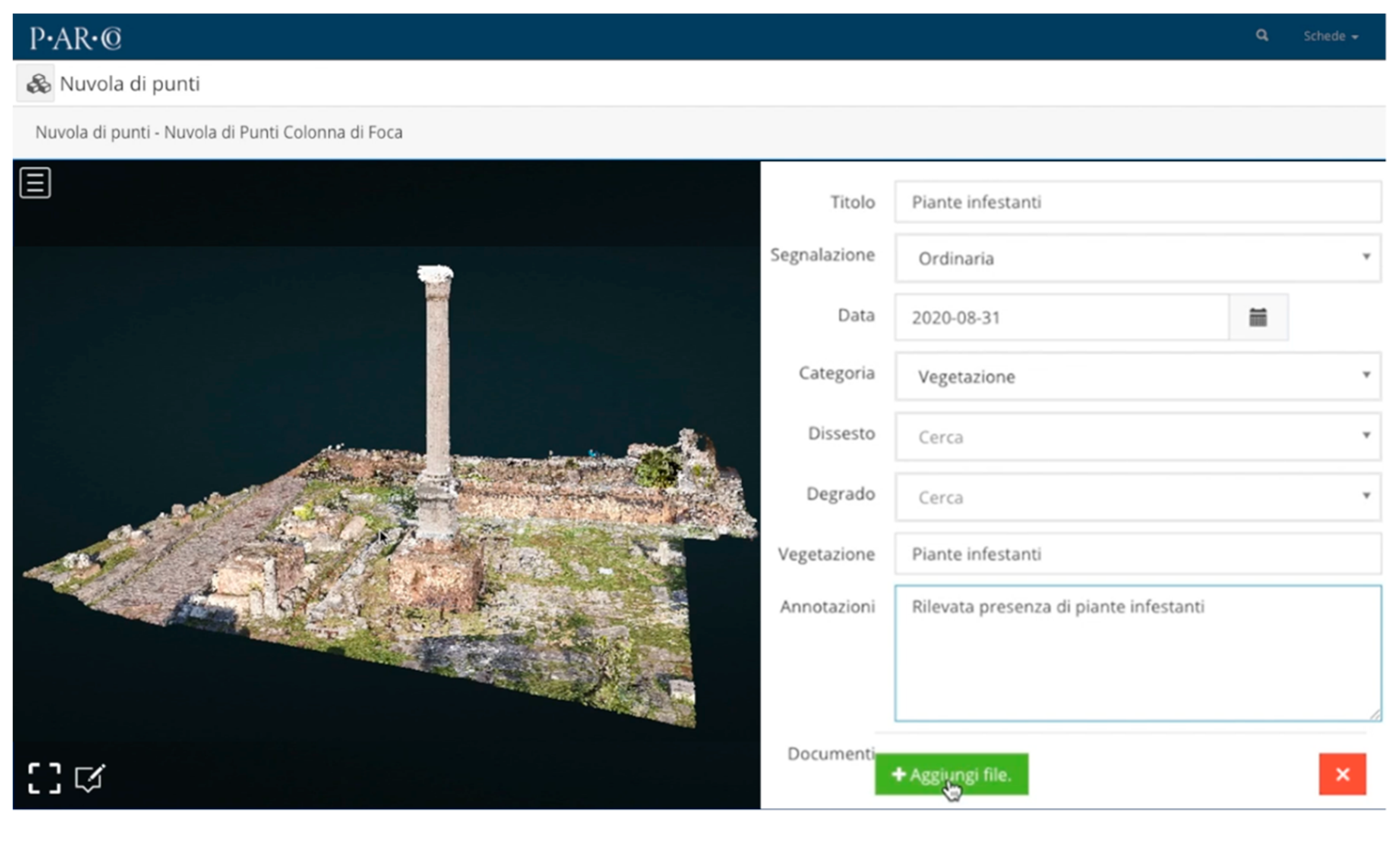
It should be pointed out that in some archaeological sites systems for monitoring and planned maintenance have already been in place for some time. In these cases the management of information, linked to the characteristics of the archaeological assets, has been structured according to types (lintels, floors, frescos, mosaics, etc.) and objects [23,24]. This method has undoubtedly given excellent results, but it cannot be applied everywhere. In the case of the Parco it is not possible to trace the assets to repetitive building or decorative typologies, due to the heterogeneity of the structures, as well as to other factors such as the different historical events that have conditioned the state of preservation with phases of reuse in post-antique times. For this reason, it was deemed necessary to develop an experiment that would allow the identification of protocols of activities in the field for both monitoring and maintenance based on the method rather than on the type of monument. It is also based on the method that a very simple and intuitive expeditious monitoring form was developed, manageable from a smartphone or tablet through an app. GIS-BIM-IoT navigation in the system is facilitated thanks to a 3D model derived from modern video game consoles. Any operator in the field will be able to enter the geo-referenced data of the area concerned. In the platform the visualization of the monument, thanks to the GUI graphic interface, can be two-dimensionally linked to the georeferenced cartography or integrated with the point cloud of the archaeological area obtained by laser scanner, in order to have a three-dimensional image on which to place any factors of degradation highlighted. The first step is to locate the operator and confirm the position. A dedicated interface will allow the position to be managed manually as well. The second step is to fill in the cards with the information from the autopsy monitoring. To correlate the event information, the user can analyse the 3D model in detail with all its functions, attach any documentation and enter a note. The third step is that, once the report is complete, the data can be checked before being sent to the system; a further pop-up confirms the correct procedure. Once a report has been created, here understood as an interactive process, the system will automatically deliver it to the user responsible for validation. The user responsible for validation is responsible for transforming the report into a notification, guaranteeing this status to those events that are actually negative. As already mentioned, the Sectors of the Park and the individual Monuments were first identified. Each monument has been assigned a code that, together with the sector number, univocally identifies the asset. Then the competences of the single users and the different user levels were identified. Actions and responsibilities correspond to the different user levels. Each user level can correspond to one or more actions, and one or more responsibilities. For this purpose, an “architecture” of responsibilities was created for each user level in relation to functional and area competences.
Thanks to AR, which is particularly useful for the recognition of weed species, the identification procedure and the compilation of the shipping forms can also be achieved through the camera of the maintenance devices (tablets). Dedicated training courses will enable all the Parco’s staff, including the security and reception staff, to take an active part in safeguarding and protecting its monuments: with the provided tablet they will be able to send the system the dispatch forms on any situations of deterioration (Figure 11).
The system is also able to manage a further level of reporting, represented by the alert reserved for objectively dangerous or serious phenomena, which follows a similar path but with its own automatic mechanisms, so that it does not require the validation of the competent official but arrives directly on the desk of the responsible official (see below).
3.4. Archaeological Heritage Register and HBIM
For a correct assessment of the vulnerability and risk of the monument, it is fundamental to know the effects and identify the causes of degradation, a function that cannot be fulfilled only by the expedition cards. As already mentioned, fundamental components of the database are all the information that constitutes the technical register of the monument, i.e., the detailed knowledge of the monumental archaeological heritage. The technical register contains the exact consistency of the physical characteristics (dimensions, materials, etc.), technical characteristics (typology, masonry equipment, etc.), mechanical characteristics, where relevant, and conservation characteristics (degradation, disruption, deformation phenomena, etc.). This information is translated through the tool of infographic modelling known as HBIM [25,26,27].
To this end, with the aim of making the models produced comparable and interrogable, as well as standardizing the procedures inherent in the knowledge process, SyPEAH has been configured to manage the data using a dynamic HBIM model, for the use of which the HBIM Process Guidelines containing the information necessary for the definition and management of the Digital Work are currently being prepared. The main objective of the Guidelines is to standardise the results of the data related to the archaeological heritage, through the use of identifiable, repeatable and state-of-the-art methodologies that guarantee a high degree of precision together with a speed of execution, as well as procedures identified in specific regulatory provisions. The aim of this activity is to systematise the set of graphic, photographic and documentary information that fully describes the current state of knowledge of the asset. In this way, SyPEAH is provided with BIM infographic models which replicate the consistencies in the actual state, and which allow the organisation and management of all the information collected there (digital twin). It should be noted that BIM applied to cultural heritage, HBIM, is still in an experimental phase, above all due to the difficulty, highlighted several times, of parameterising and managing morphologically complex forms, such as archaeological heritage, characterised by typological and constructive variety. In fact, in a digital model, surfaces and volumes are referred to quantifiable and qualifiable values and characteristics; for this reason, the management and representation of metre-morphological data in HBIM must be converted into descriptive models of the form, to which qualitative characteristics can be attributed that relate to the mechanical-functional characteristics of the asset [28,29,30,31]. A detailed description of each monument will then be provided, both from a technical point of view, such as the materials used and the construction techniques, the roofing and so on, and from the point of view of degradation and structural, static and dynamic instability. Degradation must also be detected and documented through a mapping of the state of conservation, drawn on a straightened photo of the object (e.g., a wall or floor) in open vector graphic format (svg) and on a scanner survey. This operational phase, coinciding with the reconnaissance activity carried out by the non-dispatchable inspection teams, constitutes the necessary basis for the definition of prevention and maintenance strategies. Unlike the expeditious in situ monitoring activities, the inspection activities and the drafting of the documentation aimed at establishing the technical register will be carried out jointly by teams made up of the following professional figures, including those from outside the Administration: archaeologist, architect, engineer, restorer, surveyor, and photographer specialising in filming Cultural Heritage. The inspection activities are associated with the definition of the “degradation module”: the aim is to identify the conditions of degradation and risk based mainly on careful visual investigations that, through an assessment of pathologies and the various phenomena of degradation, ensure the identification of risks and priorities. From a procedural point of view, autopsy observation is the fundamental prerequisite for the definition of a prediagnosis of the technical elements and, subsequently, for the design and validation of the diagnosis.
The information collected shall be filed and organised in the Information System, according to the criteria indicated in the relevant management and operational instructions. The whole cognitive process is thus aimed at acquiring the necessary information for the development of a temporal and financial planning of the maintenance operations that the Parco shall provide for the future management of the asset. In fact, on the basis of the information recorded it will be possible to highlight the characteristics of the object and identify its criticality, urgency and priorities. To this end, four main categories of criticality have been identified:
- −
- structural criticality, related to structural deficiencies, mechanical properties of masonry and seismic and hydrogeological risk.
- −
- material criticality, relating to surface alteration phenomena.
- −
- technological criticality, anomalies or failures found in significant technical elements, not least the effectiveness of previous interventions.
- −
- criticality of use: vulnerability is ascertained in relation to inappropriate use of the asset.
These criticalities can make the asset vulnerable, i.e., exposed to damage or degradation due to an external agent linked to environmental or anthropogenic hazard conditions.
For the identification and classification of the state of conservation of natural and artificial stone materials (the vocabulary relating to the ‘type’ of degradation) reference is made to the UNI 11182/2006 Standards (replacing NOR.MA.L. Recommendations 1/80 and 1/88), which provide a description of the terms useful for indicating the various forms of surface alteration and the organisms visible macroscopically. With regard to the structural problems and deterioration caused by weed vegetation, special sheets with specific legends have been drawn up.
These criticalities can make the asset vulnerable, i.e., exposed to being damaged or degraded by an external agent related to environmental or anthropogenic hazard conditions. Vulnerability represents an intrinsic characteristic of the exposed element; it is directly dependent on its degradation or state conditions and relates the action to the damage it may cause.
3.5. SyPEAH Predictive Alerting
The development of a system of qualitative and quantitative assessment of the ruined monument and of a procedure to establish a priority ranking of the interventions to be carried out is crucial for the verification of the risk of loss of the asset.
This is an aspect that has been addressed several times, especially after the 2006 earthquake, particularly for historical-artistic heritage. Even the fundamental Guidelines for the evaluation and reduction of seismic risk of cultural heritage—alignment with the new Technical Standards for Construction, which fully implement the document approved by the Superior Council of LL PP in the General Assembly of 23 July 2010, have as their subject the architectural heritage of historical-artistic value in relation to seismic action. Nothing of the kind concerns monuments in a state of ruin, which, as already pointed out, due to their intrinsic and extrinsic characteristics escape the possibility of being classified according to structural typologies and defined parameters referable to mathematical models. Moreover, the above-mentioned guidelines concern the identification and verification of seismic safety levels, while what is considered essential for archaeological assets for management purposes is the assessment of the risk of loss of the asset or the verification of vulnerability, not necessarily related to seismic risk.
It is precisely this aspect in particular, i.e., the management aspect, that differentiates SyPEAH from the aforementioned Risk Map created by IsCR, a project for the census of the state of conservation of the Italian cultural heritage which, with SIT Maris, has developed a vulnerability assessment system consisting of algorithms elaborated on the basis of individual and territorial risk models that take into account natural, climatological, atmospheric pollution and anthropic phenomena as variables of the relative structural, environmental and anthropic hazard indices [32,33,34,35,36].
Therefore, while the SIT Maris project surveys the state of conservation of cultural assets, not only archaeological, attempting to interrelate the causes with the effects, SyPEAH seeks to propose a management model for archaeological structures which is fast, agile and immediate, relating the effects caused by risk factors to the actions taken to safeguard the assets themselves: the management system which derives from this constitutes the truly innovative element of the entire logical architecture of the WebAPP.
In essence, in order to achieve the predictive evaluation mentioned above, SyPEAH operates through the construction of a system based on algorithms that develop the interrelation between satellite data, geological data, data from ground-based diagnostic instruments, and objective data regarding the consistency of the archaeological heritage, such as instability, degradation, and infesting vegetation (Figure 12). This process generates, when necessary, a predictive alert, which is followed by maintenance work according to the most appropriate methods.
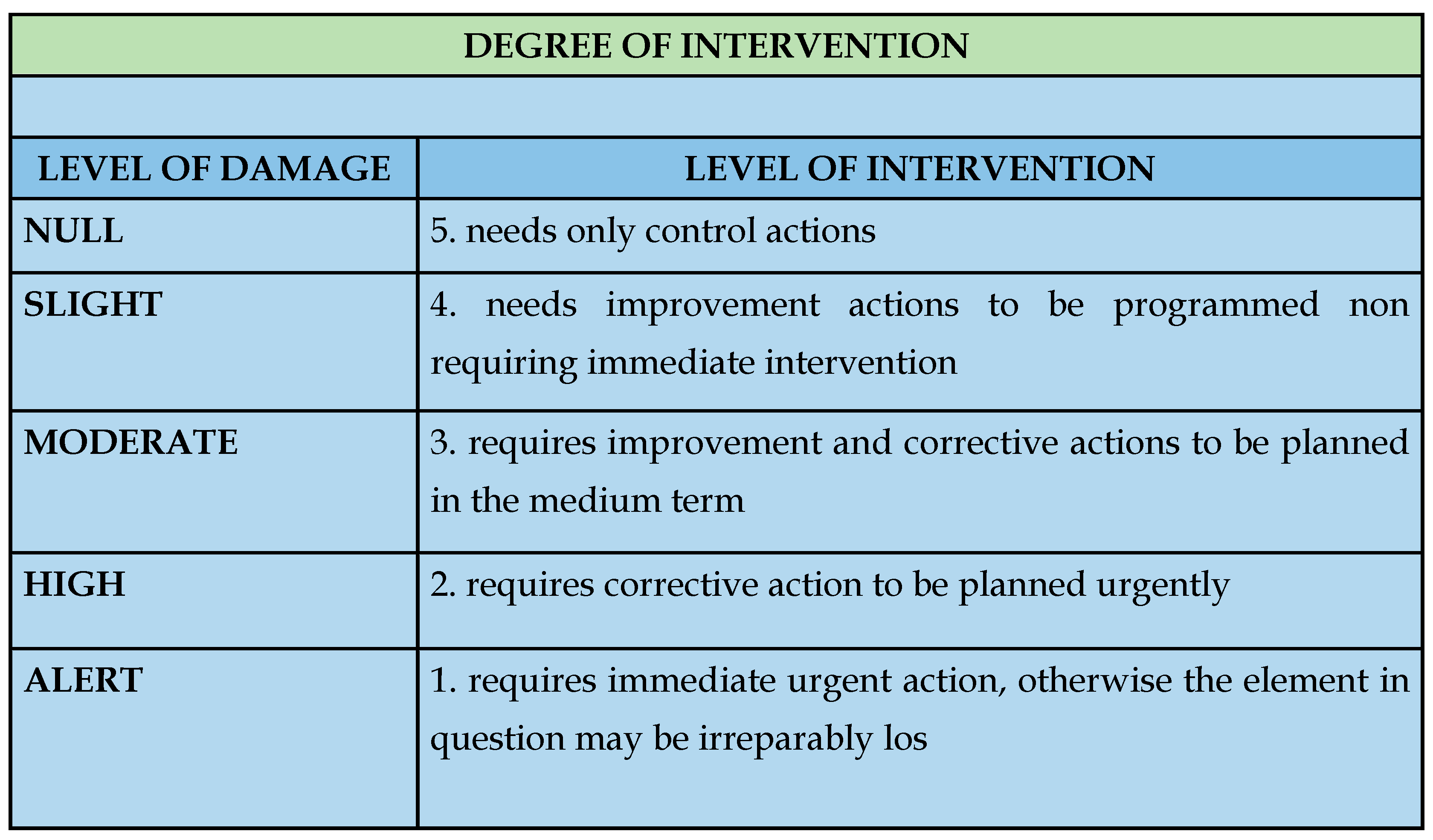
Once a class of damage has been identified with reference to structural instability, degradation, the connection between soil deformation and displacement measurements indicated by satellite data, data from diagnostic instruments interrelated with geological data, and the effects of weed vegetation according to IP/M, the relationship between the severity given by the aforementioned class of damage and the importance of the event recorded in the system given by the aspects involved is able to elaborate an automatic alert that induces immediate intervention (Figure 13).
4. Discussion: Planned Maintenance and Preventive Restoration
The study of the effects of deterioration, damage or infesting vegetation on the archaeological structures in connection with the causes is functional for the removal of the factors that determine them and for the implementation of a programmed maintenance plan or preventive restoration interventions. In other words, through the identification of the elements on which to intervene and the activities to be carried out, on the basis of a precise knowledge of the assets present in the area examined, through the systemisation of the previous and current documentation and thanks to the information derived from the monitoring system, having identified the procedure to be followed and learned from SyPEAH through the use of the IA, the plan of maintenance and preventive restoration activities is drawn up.
In general, the routine maintenance plan provides for a schedule of checks to be carried out at set intervals. To this end, with the wealth of information that make up the technical registry of archaeological assets, the definition of criticality levels, the identification of a system of vulnerability assessment and predictive alert through a special algorithm, it was planned to “teach” the system to process “autonomously” the actions to be taken to schedule maintenance. In short, it is intended to apply to the system the techniques of Machine Learning, based on the use of artificial neural networks to multiple layers (hidden layers) to process information and a supervised learning model based on regression [37,38,39,40,41]. It should be noted that given the learning time, based on data still being developed and implemented to populate the system, this phase is still being developed and tested. In order not to make the training phase too onerous and complex, it was decided to work with a limited number of weights, i.e., parameters to be learned. The starting point is the interconnection between the state of conservation, criticality, restoration/action/intervention, maintenance, timetable, works/costs. For each type of criticality/deterioration one or more actions or restoration and/or consolidation interventions have been identified; each of these corresponds to a maintenance plan with the relative annual time schedule. Each action/restoration intervention corresponds to one or more items of work with the relative costs from the price list (Figure 14).
This is another of SyPEAH’s innovative elements, such as the predictive alert, the development of which is the result not only of an in-depth study but also of a long discussion with the working group. The aim, therefore, is not only to develop maintenance activities, but also to make administrative action easier and faster. For this reason, another function linked to the activities is calendar management with the sending of notifications before and after the intervention to follow and document the action in all its levels. The user identified with the competent profile will receive a notification in due time with a reminder of the action to be performed. The calendar collects all ordinary and extraordinary maintenance actions, managing all the information and documentation produced. This makes it possible not only to archive the technical documentation produced for each intervention, but also to monitor the activity of the company or companies appointed, which will be able to send daily or even weekly reports on the work carried out. Access to the calendar function also allows the temporal display of scheduled interventions and the urgency of the intervention. In order to update the information in real time as it becomes available, in the site sheet, in addition to displaying the essential information on the monument or area analysed, accompanied by photos, plans, 3D reliefs and other documentation, the user enabled for this purpose can compile a brief description of the work carried out and enter any data for examining the anomalies found.
5. Conclusions
The app developed for the reporting and notification system, easy and intuitive, usable also by non-experts thanks to the use of AR, could have developments also for the enhancement activity, which responds to the need for knowledge and history that underlies cultural tourism. In addition to having an operational management system, in this way it would be possible to transform the ruins that emerge from the ground as fragments of history into signs that can be understood even by non-experts in the field. From this point of view, enhancement would be the goal of the research process guaranteed by protection [42].
The study and analyses carried out for the monitoring and maintenance project have therefore led to the development of what can be considered one of the most innovative elements of SyPEAH, namely the development of a methodology, which will allow a new approach to the archaeological heritage, operational-managerial but also cultural, with the systemisation of information and its dissemination and accessibility. Through a holistic, integrated, trans-sectoral and trans-disciplinary approach, which considers economic, social, cultural and environmental systems for sustainable management, SyPEAH reveals opportunities for innovation in which ITC plays a key role in promoting inclusion, leading to safeguarding and protection activities, in order to guarantee conservation for future generations and benefits also in the field of education and knowledge dissemination, with the overcoming of the digital divide and thus also of the inequality in the possibilities of access to telematic services and means of communication, with the creation of public services for the enhancement of high quality cultural heritage.
Following the path traced by SyPEAH, which goes from protection to the democratisation of culture through its dissemination and accessibility, the system of actions aimed at increasing the resilience of cultural heritage becomes a fundamental means of communication and therefore of transmission.
Funding
SyPEAH and the related laboratory, designed by the Author of this paper, have been funded by the Parco, where they are being implemented (Pgt. 333-18-2.1.2.021-Del. n. 15 dated 11/09/2018- RUP, Designer and DEC Dr Irma Della Giovampaola).
Data Availability Statement
Data for SyPEAH can be found at the Parco’s monitoring lab, for which the Author is responsible.
Acknowledgments
The Author would like to sincerely thank the Park Director Alfonsina Russo, who believed in the project. She would also like to thank Architect Alessandra Petretto, with whom she has constantly discussed many issues and whose proactive support has been fundamental in every phase of the development of the system; in addition she would like to thank Engineers Valerio Rughetti and Fabio Maschietti for technical support on computer aspects and for the preparation of the laboratory; finally her colleague Landscape Arch. Gabriella Strano who oversaw the reworking of the IP, allowing the development of the IP/M and the geologist Carlo Rosa for the elaboration of the geological map of the Parco. Thanks are also due to the Italian Space Agency (ASI), in particular Alessandro Coletta and Maria Virelli, who followed the project with regard to the satellite aspects.
Conflicts of Interest
The author declares no conflict of interest.
References
- 21252030 Agenda for Sustainable Development web.pdf (un.org). Available online: https://sustainabledevelopment.un.org/content/documents/21252030%20Agenda%20for%20Sustainable%Development%20web.pdf (accessed on 4 June 2021).
- Russo, A.; Della Giovampaola, I. (Eds.) Monitoraggio e manutenzione delle aree archeologiche. In Proceedings of the Cambiamenti Climatici, Dissesto Idrogeologico, Degrado Chimico-Ambientale, Atti del Convegno Internazionale di Studi, Roma, Italy, 20–21 March 2019. (Bibliotheca Archaeologica 65). [Google Scholar]
- Bertolin, C. Preservation of Cultural Heritage and Resources Threatened by Climate Change. Geosciences 2019, 9, 250. Available online: https://0-www-mdpi-com.brum.beds.ac.uk/2076-3263/9/6/250 (accessed on 4 June 2021). [CrossRef] [Green Version]
- Special Report IPCC 2018. Global Warming of 1.5 °C. An IPCC Special Report on the Impacts of Global Warming of 1.5 °C above Pre-Industrial Levels and Related Global Greenhouse Gas Emission Pathways, in the Context of Strengthening the Global Response to the Threat of Climate Change, Sustainable Development, and Efforts to Eradicate Poverty. In Press. In part. Fig. 3.3. Available online: https://www.ipcc.ch/sr15 (accessed on 4 June 2021).
- Moscati, P. Informatica archeologica e archeologia digitale: Le risposte dalla rete. Archeol. e Calc. 2019, 30, 21–38. [Google Scholar]
- Brandi, C. The Theory of Restoration; (Teoria del restauro, (PBE 53) Torino 1963), in part; Istituto Centrale per il Resta: Firenze, Italy, 2005; pp. 31, 56–57. [Google Scholar]
- Procedure per la Gestione Delle Attività di Messa in Sicurezza e Salvaguardia del Patrimonio Culturale in Caso di Emergenze Derivanti da Calamità Naturali. Available online: https://storico.beniculturali.it/mibac/multimedia/MiBAC/documents/1437986288170_DIRETTIVA_23Aprile2015.pdf (accessed on 4 June 2021).
- Strategia Nazionale di Adattamento ai Cambiamenti Climatici. Available online: https://pdc.miniambiente.it/sites/default/files/allegati/strategia_nazionale_adattamenti_climatici.pdf (accessed on 4 June 2021).
- Garzia, G. Rischi da Calamità Naturali e Tutela Preventiva dei Beni Culturali. Pausania. 2017. Available online: https://www.pausania.it/giuseppe-garzia-rischi-da-calamita-naturali-e-tutela-preventiva-dei-beni-culturali/ (accessed on 4 June 2021).
- Della Torre, S. Restauro e progetto per l’archeologia. In Restaurando Pompei. Riflessioni a Margine del Grande Progetto; Osanna, M., Picone, R., Eds.; L’Erma di Bretschneider: Rome, Italy, 2018; pp. 41–45. [Google Scholar]
- Signorini, M.A. L’Indice di Pericolosità: Un contributo del botanico al controllo della vegetazione infestante nelle aree monumentali. Inf. Bot. 1996, 28, 7–14. [Google Scholar]
- Tapete, D.; Fanti, R.; Cecchi, R.; Petrangeli, P.; Casagli, N. Satellite radar interferometry for monitoring and early-stage warning of structural instability in archaeological sites. J. Geophys. Eng. 2012, 9, S10–S25. [Google Scholar] [CrossRef]
- Cigna, F.; Lasaponara, R.; Masini, N.; Milillo, P.; Tapete, D. Persistent Scatterer Interferometry Processing of COSMO-SkyMed StripMap HIMAGE Time Series to Depict Deformation of the Historic Centre of Rome, Italy. Remote Sens. 2014, 6, 12593–12618. [Google Scholar] [CrossRef] [Green Version]
- Tapete, D.; Cigna, F. InSAR data for geohazard assessment in UNESCO World Heritage sites: State-of-the-art and perspectives in the Copernicus era. Int. J. Appl. Earth Obs. Geoinf. 2017, 63, 24–32. [Google Scholar] [CrossRef]
- Virelli, M. ASI COSMO-SkyMed: Mission Overview and Data Exploitation. IEEE Geosci. Remote Sens. Mag. 2014, 2, 64–66. [Google Scholar] [CrossRef]
- Tapete, D.; Cigna, F. COSMO-SkyMed SAR for Detection and Monitoring of Archaeological and Cultural Heritage Sites. Remote. Sens. 2019, 11, 1326. [Google Scholar] [CrossRef] [Green Version]
- Virelli, M.; Coletta, A.; Tapete, D.; Cigna, F. Cosmo SkyMed: Uno Strumento Satellitare per il Monitoraggio dei Beni Culturali. In Monitoraggio e Manutenzione Delle Aree Archeologiche. Cambiamenti Climatici, Dissesto Idrogeologico, Degrado Chimico-Ambientale, Proceedings of the atti del Convegno Internazionale di Studi, Roma, Italy, 20–21 March 2019; Russo, A., Della Giovampaola, I., Eds.; (Bibliotheca Archaeologica 65); L’Erma di Bretschneider: Rome, Italy, 2020; pp. 103–112. [Google Scholar]
- Iadanza, C.; Leoni, G.; Spizzichino, D.; Trigila, A.; Margottini, C. Processi di instabilità e analisi di dati satellitari nel Parco archeologico di Pompei. In Monitoraggio e Manutenzione delle Aree Archeologiche. Cambiamenti Climatici, Dissesto Idrogeologico, Degrado Chimico-Ambientale, Proceedings of the Atti del Convegno Internazionale di Studi, Roma, Italy, 20–21 March 2019; Russo, A., Della Giovampaola, I., Eds.; (Bibliotheca Archaeologica 65); L’Erma di Bretschneider: Rome, Italy, 2020; pp. 159–164. [Google Scholar]
- Tapete, D.; Morelli, S.; Fanti, R.; Casagli, N. Localising deformation along the elevation of linear structures: An experiment with space-borne InSAR and RTK GPS on the Roman Aqueducts in Rome, Italy. Appl. Geogr. 2015, 58, 65–83. [Google Scholar] [CrossRef] [Green Version]
- Crosetto, M.; Monserrat, O.; Cuevas-Gonzales, M.; Devanthéry, N.; Luzi, G.; Crippa, B. Measuring thermal expansion using X-band persistent scatterer interferometry. ISPRS J. Photogramm. Remote Sens. 2015, 100, 84–91. [Google Scholar] [CrossRef] [Green Version]
- Russo, A.; Della Giovampaola, I. Il monitoraggio e la manutenzione delle aree archeologiche: Il piano per il futuro del Parco archeologico del Colosseo. In Monitoraggio e Manutenzione delle Aree Archeologiche. Cambiamenti Climatici, Dissesto Idrogeologico, Degrado Chimico-Ambientale, Proceedings of the Atti del Convegno Internazionale di Studi, Roma, Italy, 20–21 March 2019; Russo, A., Della Giovampaola, I., Eds.; (Bibliotheca Archaeologica 65); L’Erma di Bretschneider: Rome, Italy, 2020; pp. 13–31. [Google Scholar]
- Russo, A.; Della Giovampaola, I.; Leoni, G.; Spizzichino, D.; Coletta, A.; Virelli, M. The project of Parco archeologico del Colosseo and the Italian archaeological parks network: From satellite monitoring to conservation and preventive maintenance policies. In Proceedings of the Sustainable Conservation of UNESCO and Other Heritages Sites trough Proactive Geosciences, Luxor-Aswan, Egypt, 10–12 December 2019. in press. [Google Scholar]
- D’Andrea, A.; Laino, A.; Pesaresi, P.; Sirano, F. La scienza delle cose semplici. Esperienze di manutenzione ad Ercolano. In Monitoraggio e Manutenzione delle Aree Archeologiche. Cambiamenti Climatici, Dissesto Idrogeologico, Degrado Chimico-Ambientale, Proceedings of the Atti del Convegno Internazionale di Studi, Roma, Italy, 20–21 March 2019; Russo, A., Della Giovampaola, I., Eds.; (Bibliotheca Archaeologica 65); L’Erma di Bretschneider: Rome, Italy, 2020; pp. 51–59. [Google Scholar]
- Osanna, M.; Rinaldi, E. Il sistema programmato di prevenzione e manutenzione di Pompei: Dalla sperimentazione al metodo. In Monitoraggio e Manutenzione delle Aree Archeologiche. Cambiamenti Climatici, Dissesto Idrogeologico, Degrado Chimico-Ambientale, Proceedings of the Atti del Convegno Internazionale di Studi, Roma, Italy, 20–21 March 2019; Russo, A., Della Giovampaola, I., Eds.; (Bibliotheca Archaeologica 65); L’Erma di Bretschneider: Rome, Italy, 2020; pp. 35–43. [Google Scholar]
- Eastman, C.; Teicholz, P.; Sacks, R.; Liston, K. BIM Handbook: A Guide to Building Information Modeling for Owners, Managers, Designers, Engineers and Contractors; Wiley: Hoboken, NJ, USA, 2018. [Google Scholar]
- Daniotti, B.; Gianinetto, M.; Della Torre, S. (Eds.) Digital Transformation of the Design, Construction and Management Processes of the Built Environment; Springer: Cham, Switzerland, 2020. [Google Scholar]
- Tanga, S.; Sheldena, D.R.; Eastman, C.M.; Pishdad-Bozorgib, P.; Gao, X. A review of building information modeling (BIM) and the internet of things (IoT) devices integration: Present status and future trends. Autom. Constr. 2019, 101, 127–139. [Google Scholar] [CrossRef]
- Achille, C.; Lombardini, N.; Valentini, M. Aree archeologiche e BIM: Prove di compatibilità. Documentazione e protezione delle aree archeologiche. In ICT per il Miglioramento Conservativo, PPC 2014; Della Torre, S., Ed.; Nardini: Florence, Italy, 2014; pp. 113–123. [Google Scholar]
- Arrighetti, A.; Pancani, G.; Gentili, M. La pieve di Santa Maria a Bujano. In Casentino. Rilievo, Lettura Archeologica e H-BIM delle Architetture. Archeologia dell’Architettura XIV; Under the sign of Giglio: Florence, Italy, 2019; pp. 157–176. [Google Scholar]
- Della Torre, S.; Pili, A. Built Heritage Information. Modelling/Management. Research Perspectives. In Digital Transformation of the Design, Construction and Management Processes of the Built Environment; Daniotti, B., Gianinetto, M., Della Torre, S., Eds.; Springer: Cham, Switzerland, 2020; pp. 231–242. [Google Scholar]
- Brumana, R.; Oreni, D.; Barazzetti, L.; Cuca, B.; Previtali, M.; Banfi, F. Survey and Scan to BIM Model for Knowledge of Built Heritage and the Management of Conservation Activities. In Digital Transformation of the Design, Construction and Management Processes of the Built Environment; Daniotti, B., Gianinetto, M., Della Torre, S., Eds.; Springer: Cham, Switzerland, 2020; pp. 391–400. [Google Scholar]
- Carta del Rischio. Available online: http://www.lorenzomucchi.info/DOCS/LETT/INFCULT/La%20carta%20del%20rischio.pdf (accessed on 4 June 2021).
- Cacace, C. Il SIT—Sistema Informativo Territoriale della Carta del Rischio. In Quarto Seminario Internazionale di Studi Sulle Mura Poligonali; atti del convegno; Attenni, L., Baldassarre, D., Eds.; Palazzo Gentili: Rome, Italy, 2012; pp. 361–368. [Google Scholar]
- Cacace, C.; Giovagnoli, A.; Gaddi, R. Gli impatti dei cambiamenti climatici e dell’inquinamento atmosferico sui beni culturali di Ancona. Boll. ICR 2014, 28, 47–67. [Google Scholar]
- Acierno, M.; Cacace, C.; Giovanoli, A. La Carta del Rischio: Un approccio possibile alla manutenzione programmata. Il caso di Ancona. In Materiali e Strutture. Problemi di Conservazione Prima e Dopo il Restauro; N.S. III; Edizioni Quasar: Rome, Italy, 2014; Volume 5–6, pp. 81–106. [Google Scholar]
- Cacace, C. La Carta del Rischio per il patrimonio culturale. In Il Futuro dei Centri Storici. Digitalizzazione e Strategia Conservativa; (Percorsi. Città e architetture nel tempo); Fiorani, D., Ed.; Edizioni Quasar: Rome, Italy, 2019; pp. 65–74. [Google Scholar]
- McCulloch, W.; Pitts, W. A logical calculus of the ideas immanent in nervous activity. Bull. Math. Biophys. 1943, 52, 115–133. [Google Scholar] [CrossRef]
- Rumelhart, D.E.; Hinton, G.E.; Williams, R.J. Learning Internal Representations by Error Propagation; California University San Diego La Jolla Institute for Cognitive Science: San Diego, CA, USA, 1985. [Google Scholar]
- Kingma, D.P.; Ba, J.A. A method for stochastic optimization. arXiv 2014, arXiv:1412.6980. [Google Scholar]
- Lecun, Y.; Bengio, Y.; Hinton, G. Deep learning. Nature 2015, 521, 436–444. [Google Scholar] [CrossRef] [PubMed]
- Vaswan, N.; Shazeer, N.; Parmar, N.; Uszkoreit, J.; Jones, L.; Gomez, A.G.; Kaiser, L.; Polosukhin, I. Attention is all you need. arXiv 2017, arXiv:1706.03762. [Google Scholar]
- Manacorda, D. Il Sito Archeologico fra Ricerca e Valorizzazione; (Le Bussole 279); Carocci: Rome, Italy, 2007; p. 93. [Google Scholar]
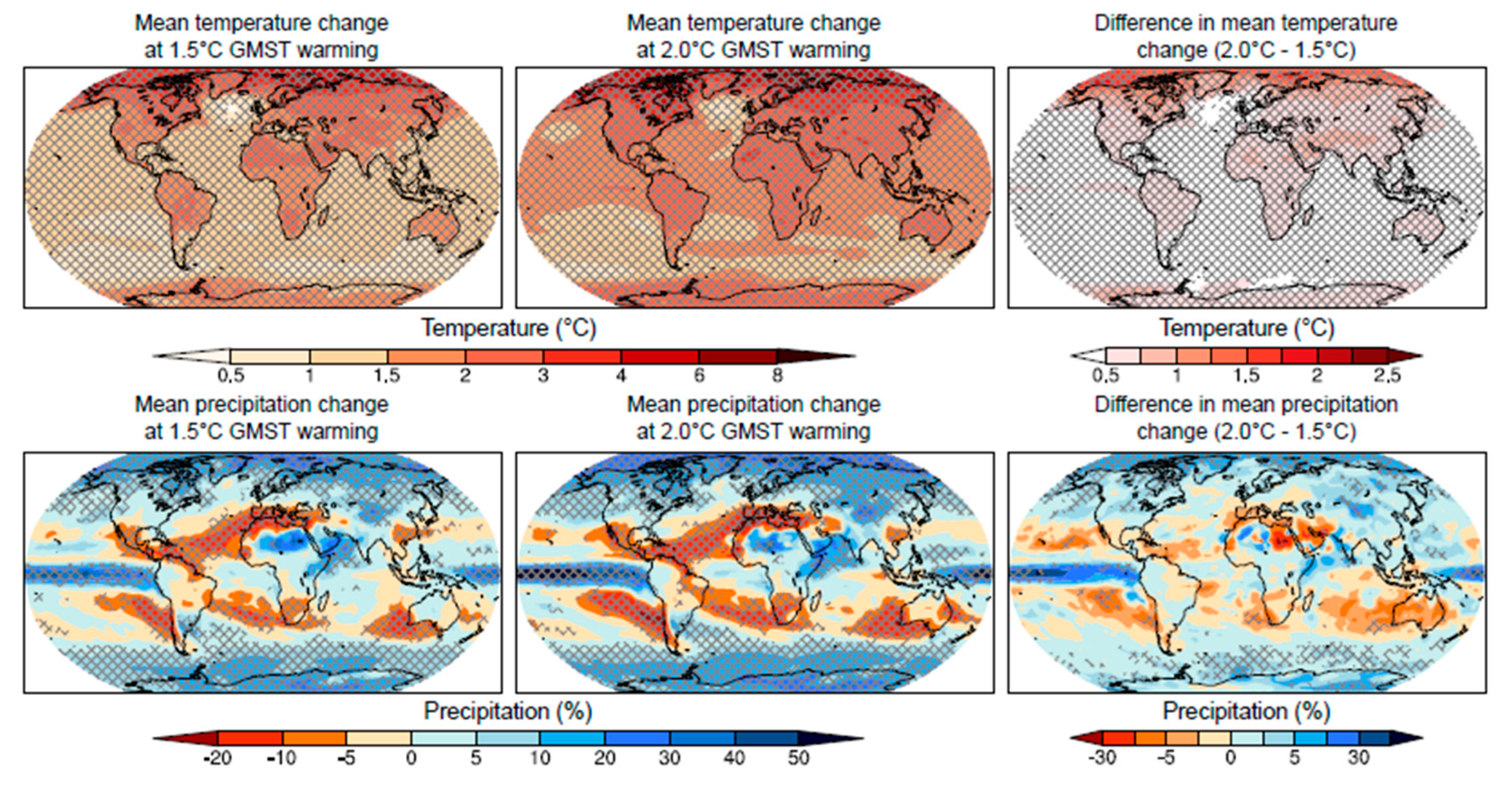
Figure 1.
The figure, taken from the latest report “Global Warming of 1.5°” of the Intergovernmental Panel on Climate Change (2019) [4], unfortunately confirms the evolution of and increase in the effects produced by climate change, affecting our planet as a result of global warming, and a greater intensification of extreme events.

Figure 2.
SyPEAH, technologies employed and expected developments.

Figure 3.
SyPEAH, monitoring lab: flow diagram in the WebAPP system.

Figure 4.
Zoning of the archaeological area for the management of monitoring and maintenance activities. Through monitoring, every kind of consolidation and restoration activity can be managed considering the whole Parco structure, which for this purpose has been conventionally divided into sectors characterized by similar historical-topographical and/or morphological features (figure produced with the kind collaboration by A. Petretto).

Figure 5.
SyPEAH, 3D plan.

Figure 6.
SyPEAH, satellite map.

Figure 7.
SyPEAH, open IP protocol.

Figure 8.
SyPEAH, STA protocol.

Figure 9.
The historical satellite analysis of the Flavian Amphitheatre (e-geos).

Figure 10.
Census of measurement devices (IMG): mapping of areas with environmental monitoring systems (about 1000 in total).
Figure 10.
Census of measurement devices (IMG): mapping of areas with environmental monitoring systems (about 1000 in total).

Figure 11.
SyPEAH, signaling dashboard: the compilation of the report form is facilitated by the visualization of the monument also in 3D.
Figure 11.
SyPEAH, signaling dashboard: the compilation of the report form is facilitated by the visualization of the monument also in 3D.

Figure 12.
Schematic representation of the interrelationships involved in generating the SyPEAH predictive alert.
Figure 12.
Schematic representation of the interrelationships involved in generating the SyPEAH predictive alert.

Figure 13.
Table illustrating the level of damage identified in SyPEAH for each aspect monitored, i.e., instability, degradation, soil deformation, geology, diagnostic instrumentation, satellite data, and weed vegetation in relation to materials (figure produced with the kind collaboration by A. Petretto).

Figure 14.
SyPEAH, diagram of the neural network.

Publisher’s Note: MDPI stays neutral with regard to jurisdictional claims in published maps and institutional affiliations. |
© 2021 by the author. Licensee MDPI, Basel, Switzerland. This article is an open access article distributed under the terms and conditions of the Creative Commons Attribution (CC BY) license (https://creativecommons.org/licenses/by/4.0/).
Share and Cite
MDPI and ACS Style
Giovampaola, I.D. SyPEAH: The WebAPP System for Protection and Education to Archaeological Heritage in the Parco Archeologico del Colosseo. Geosciences 2021, 11, 246. https://0-doi-org.brum.beds.ac.uk/10.3390/geosciences11060246
AMA Style
Giovampaola ID. SyPEAH: The WebAPP System for Protection and Education to Archaeological Heritage in the Parco Archeologico del Colosseo. Geosciences. 2021; 11(6):246. https://0-doi-org.brum.beds.ac.uk/10.3390/geosciences11060246
Chicago/Turabian StyleGiovampaola, Irma Della. 2021. "SyPEAH: The WebAPP System for Protection and Education to Archaeological Heritage in the Parco Archeologico del Colosseo" Geosciences 11, no. 6: 246. https://0-doi-org.brum.beds.ac.uk/10.3390/geosciences11060246
Note that from the first issue of 2016, this journal uses article numbers instead of page numbers. See further details here.