
Distribution of Holocene Marine Mud and Its Relation to Damage from the 1923 Earthquake Disaster in the Tokyo Metropolitan Area, Japan

 , , ,
, , ,  and
and 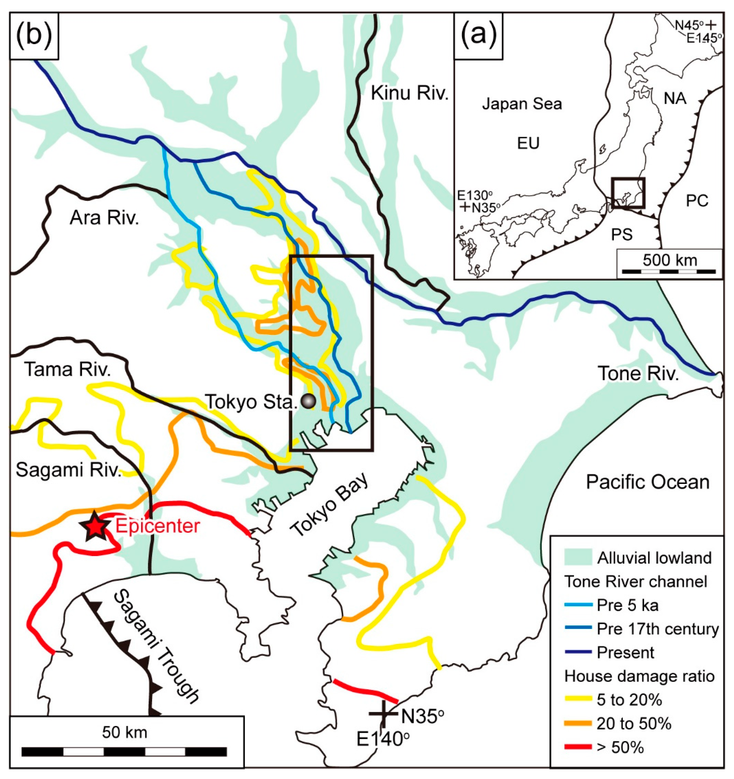
Abstract
:1. Introduction
2. Study Area
3. Materials and Methods
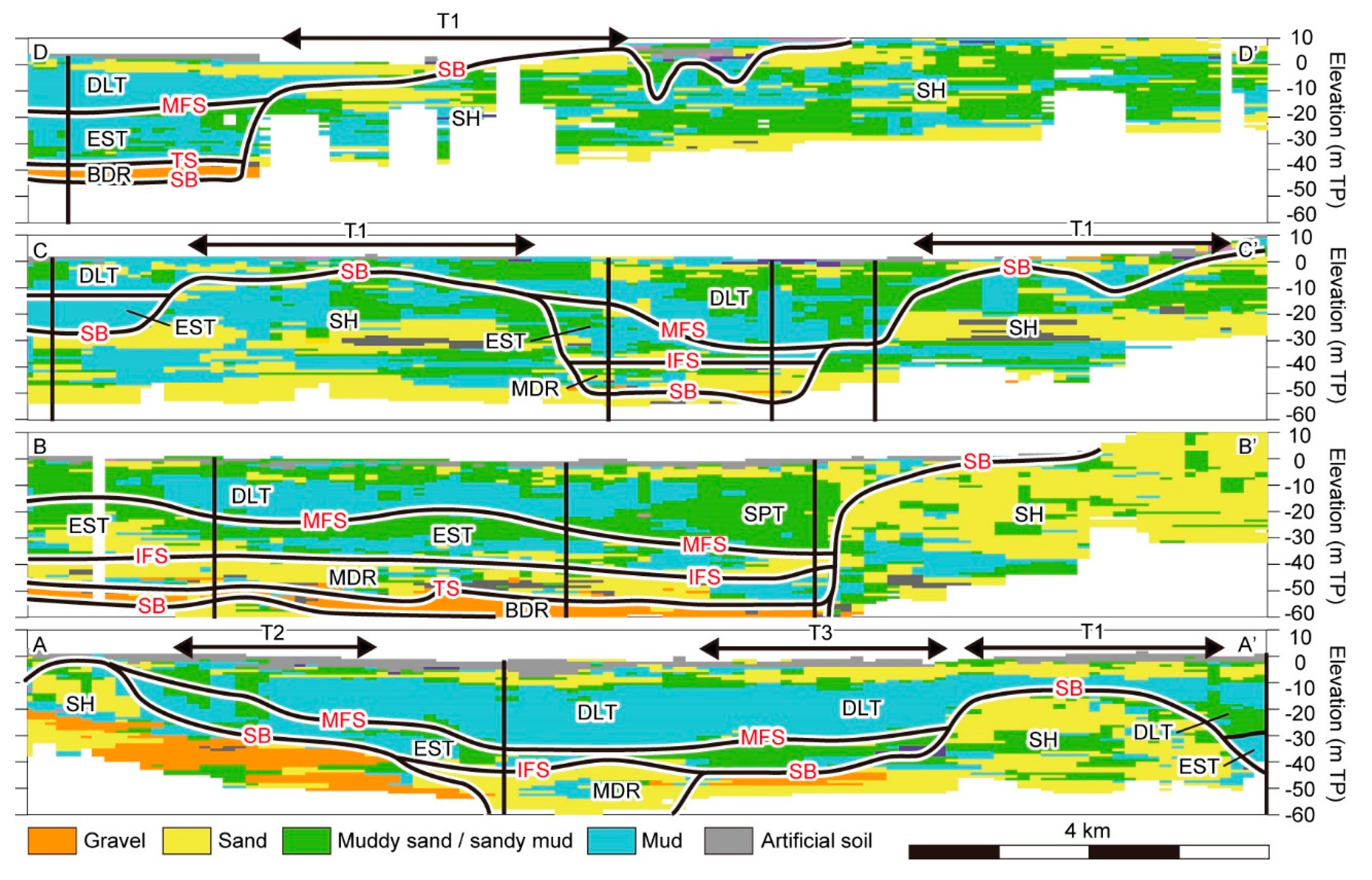
4. Geological Cross-Sections
4.1. Section AA′
4.2. Section BB′
4.3. Section CC′
4.4. Section DD′
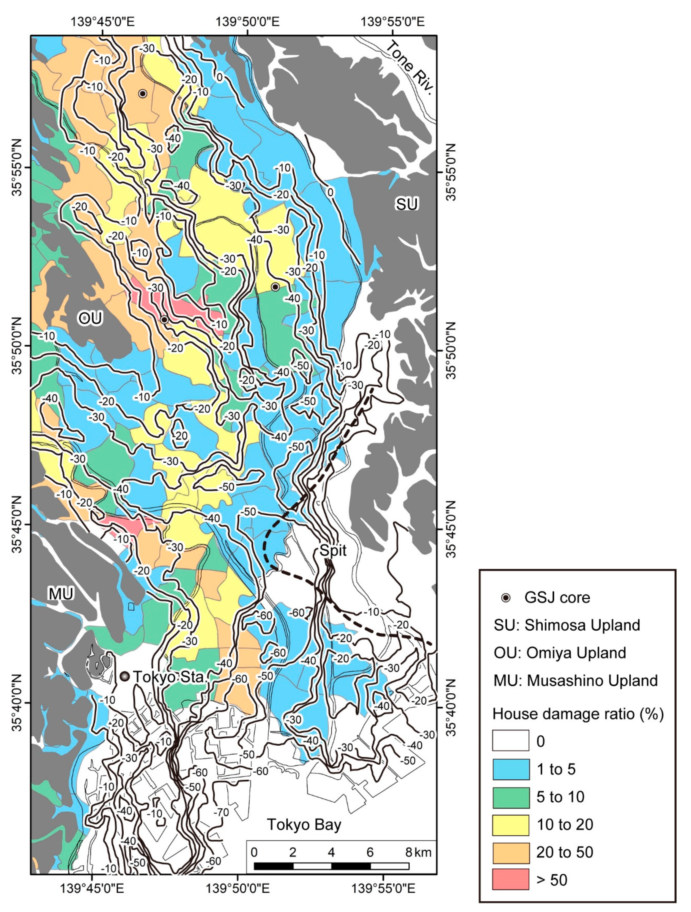
5. Incised Valleys, Buried Terraces, and Soft Mud
6. Relation between the Thicknesses of the Post-LGM Incised-Valley Fills and N1 Mud and Earthquake Damage
7. Conclusions
Author Contributions
Funding
Institutional Review Board Statement
Informed Consent Statement
Data Availability Statement
Acknowledgments
Conflicts of Interest
References
- Wikipedia. Tokyo. Available online: https://en.wikipedia.org/wiki/Tokyo (accessed on 6 May 2021).
- Hirata, N. Tokyo Metropolitan Earthquake; Iwanami Shoten: Tokyo, Japan, 2016; p. 191. [Google Scholar]
- Shishikura, M. History of the paleo-earthquakes along the Sagami Trough, central Japan: Review of coastal paleoseismological studies in the Kanto region. Episodes 2014, 37, 246–257. [Google Scholar] [CrossRef] [Green Version]
- Komori, J.; Shishikura, M.; Ando, R.; Yokoyama, Y.; Miyairi, Y. History of the great Kanto earthquakes inferred from the ages of Holocene marine terraces revealed by a comprehensive drilling survey. Earth Planet. Sci. Lett. 2017, 471, 74–84. [Google Scholar] [CrossRef]
- Matsuzawa, T. Report on distribution of earthquake damage based on wooden buildings. In Report of the Imperial Earthquake Investigation Committee, No. 100 (A); Iwanami Shoten: Tokyo, Japan, 1925; pp. 163–260. [Google Scholar]
- Building Department, Reconstruction Bureau. Report on Geological Investigation in Tokyo and Yokohama; Building Department, Reconstruction Bureau: Tokyo, Japan, 1929; 144p.
- Miyabe, N. On the vertical earth movements in Kwanto districts. Bull. Earthq. Res. Inst. Univ. Tokyo 1931, 9, 1–21. [Google Scholar] [CrossRef]
- Wikipedia. 1923 Great Kanto Earthquake. Available online: https://en.wikipedia.org/wiki/1923_Great_Kanto_earthquake (accessed on 10 June 2021).
- Kawazumi, H. On the earthquake-stricken areas and their underground formation in Tokyo, appendix-underground formation of Osaka observed through boring tests. J. Archit. Build. Sci. 1951, 66, 8–15. [Google Scholar]
- Ohsaki, Y. Earthquake damage of wooden buildings and depth of alluvial deposits. Trans. Archit. Inst. Jpn. 1962, 72, 29–32. [Google Scholar] [CrossRef]
- Kaizuka, S.; Matsuda, I. Active Tectonics and Geomorphic Division of the Tokyo Metropolitan Area and Damage Ratio due to the Kanto Earthquake of 1923. 1:200,000; Naigai Chizu: Tokyo, Japan, 1982. [Google Scholar]
- Kanai, K. On the Damage to Building by the Kawanto Earthquake. In Publications for the 50th Anniversary of the Great Kanto Earthquake, 1923; Earthquake Research Institute, the University of Tokyo: Tokyo, Japan, 1973; pp. 51–55. [Google Scholar]
- Ohsaki, Y. Earthquake and Architecture; Iwanami Shoten: Tokyo, Japan, 1983; 105p. [Google Scholar]
- Ogawa, Y.; Nakayama, T. Review of Experiential Relation between Building Damage Ratio and Thickness of Alluvial Deposits during the 1923 Kanto Earthquake; Annual Report of Civil Engineering Support and Training Center, Tokyo Metropolitan Government: Tokyo, Japan, 2009; pp. 33–42.
- Kuritsuka, K.; Ogawa, Y. Estimation of Predominant Periods in Tokyo Lowland on the Bases of Compensated Seismograph during the 1923 Kanto Earthquake; Annual Report of Civil Engineering Support and Training Center, Tokyo Metropolitan Government: Tokyo, Japan, 2014; pp. 15–20.
- Sekiguchi, H.; Yoshida, K.; Kimura, K.; Hanashima, Y. Ground motion response of the subsurface structure of the Nakagawa lowland. Misc. Map Ser. Geol. Surv. Jpn. 2014, 40, 136–177. [Google Scholar]
- Guidoboni, E.; Mariotti, D.; Giammarinaro, M.S.; Rovelli, A. Identification of amplified damage zones in Palermo, Sicily (Italy), during the earthquakes of the last three centuries. Bull. Seismol. Soc. Am. 2003, 93, 1649–1669. [Google Scholar] [CrossRef]
- Maresca, R.; Nardone, L.; Gizzi, F.T.; Potenza, M.R. Ambient noise HVSR measurements in the Avellino historical centre and surrounding area (southern Italy). Correlation with surface geology and damage caused by the 1980 Irpinia-Basilicata earthquake. Measurement 2018, 130, 211–222. [Google Scholar] [CrossRef]
- Ishihara, Y.; Miyazaki, Y.; Eto, C.; Fukuoka, S.; Kimura, K. Shallow subsurface three-dimensional geological model using borehole logs in Tokyo Bay area, central Japan. J. Geol. Soc. Jpn. 2013, 119, 554–566. [Google Scholar] [CrossRef] [Green Version]
- Tanabe, S.; Nakanishi, T.; Ishihara, Y.; Nakashima, R. Millennial-scale stratigraphy of a tide-dominated incised valley during the last 14 kyr: Spatial and quantitative reconstruction in the Tokyo Lowland, central Japan. Sedimentology 2015, 62, 1837–1872. [Google Scholar] [CrossRef]
- Tanabe, S.; Nakanishi, T.; Kimura, K.; Hachinohe, S.; Nakayama, T. Basal topography of the Alluvium under the northern area of the Tokyo Lowland and Nakagawa Lowland, central Japan. Bull. Geol. Surv. Jpn. 2008, 59, 497–508. [Google Scholar] [CrossRef] [Green Version]
- Tanabe, S.; Ishihara, Y. Incised-valley topography formed into the Last Glacial Maximum beneath the southern area of the Tokyo Lowland, central Japan. Bull. Geol. Surv. Jpn. 2020, 71, 201–213. [Google Scholar] [CrossRef]
- Stafleu, J.; Maljers, D.; Busschers, F.S.; Schokker, J.; Gunnink, J.L.; Dambrink, R.M. Chapter 11: Models created as 3-D cellular voxel arrays. In Applied Multidimensional Geological Modeling; Turner, A.K., Kessler, H., Van der Meulen, M.J., Eds.; Wiley-Blackwell: Hoboken, NJ, USA, 2021; pp. 247–271. [Google Scholar]
- Okuno, J.; Nakada, M.; Ishii, M.; Miura, H. Vertical tectonic crustal movements along the Japanese coastlines inferred from late Quaternary and recent relative sea-level changes. Quat. Sci. Rev. 2014, 91, 42–61. [Google Scholar] [CrossRef]
- Nakazawa, T.; Endo, H. Geology of the Omiya District; Quadrangle Series, 1:50,000; Geological Survey of Japan: Tsukuba, Japan, 2002; 41p. [Google Scholar]
- Ishihara, T.; Sugai, T. Eustatic and regional tectonic controls on late Pleistocene paleovalley morphology in the central Kanto Plain, Japan. Quat. Int. 2017, 456, 69–84. [Google Scholar] [CrossRef]
- Okuma, T. Influences of the river modification and the eruption of the Asama volcano at the beginning of the early modern period. Urban Kubota 1981, 19, 18–31. [Google Scholar]
- Milliman, J.D.; Farnsworth, K.L. River Discharge to the Coastal Ocean: A Global Synthesis; Cambridge University Press: Cambridge, UK, 2011; 384p. [Google Scholar]
- Chujo, J. On the Paleo-Tokyo River: Prospected by the sonic prospecting. Earth Sci. 1962, 59, 30–39. [Google Scholar]
- Kaizuka, S.; Naruse, Y.; Matsuda, I. Recent formations and their topography in and around Tokyo Bay, central Japan. Quat. Res. 1977, 8, 32–50. [Google Scholar] [CrossRef]
- Endo, K.; Kosugi, M.; Hishida, R. Holocene and latest Pleistocene deposits and their basal topography in the Kanto Plain, central Japan. Proc. Inst. Nat. Sci. Nihon Univ. 1988, 23, 37–48. [Google Scholar]
- van Wagoner, J.C.; Posamentier, H.W.; Mitchum, R.M.; Vail, P.R.; Sarg, J.F.; Louit, T.S.; Hardenbol, J. An overview of the fundamentals of sequence stratigraphy and key definitions. SEPM Spec. Publ. 1988, 42, 39–45. [Google Scholar]
- Zaitlin, B.A.; Dalrymple, R.W.; Boyd, R. The stratigraphic organization of incised-valley systems: Origin and sedimentary sequences. SEPM Spec. Publ. 1994, 51, 45–60. [Google Scholar]
- Tanabe, S. Stepwise accelerations in the rate of sea-level rise in the area north of Tokyo Bay during the Early Holocene. Quat. Sci. Rev. 2020, 248, 106575. [Google Scholar] [CrossRef]
- Geological Research Group of the Central Kanto Plain. Subsurface Geology in the Central Kanto Plain; The Association of the Geological Collaboration in Japan: Tokyo, Japan, 1994; 180p. [Google Scholar]
- Ishihara, T.; Sugai, T.; Hachinohe, S. Fluvial response to sea-level changes since the latest Pleistocene in the near-coastal lowland, central Kanto Plain, Japan. Geomorphology 2012, 147–148, 49–60. [Google Scholar] [CrossRef]
- Ministry of Land, Infrastructure, Transport and Tourism. A Guidebook for Submission of Electric Formatted Report on Geology and Soil Investigation. Available online: http://www.cals-ed.go.jp/mg/wp-content/uploads/boring71.pdf (accessed on 27 August 2019).
- Editorial Committee of “Story of N-value”. Story of N-Value; Riko Tosho: Tokyo, Japan, 1998; 188p. [Google Scholar]
- Tanabe, S.; Ishihara, Y. Formation of undulating topography and gravel beds at the bases of incised valleys: Last Glacial Maximum examples beneath the lowlands facing Tokyo Bay. Prog. Earth Planet Sci. 2021, 8, 20. [Google Scholar] [CrossRef]
- Matsuda, I. Distribution of the recent deposits and buried landforms in the Kanto Lowland, central Japan. Geogr. Rep. Tokyo Metrop. Univ. 1974, 9, 1–36. [Google Scholar]
- Machida, H.; Arai, F. Atlas of Tephra in and around Japan; University of Tokyo Press: Tokyo, Japan, 2003; 336p. [Google Scholar]
- Bureau of Port and Harbor, Tokyo Metropolitan Government. Subsurface Geological Map of Tokyo Port, New Edition; Bureau of Port and Harbor, Tokyo Metropolitan Government: Tokyo, Japan, 2001; 89p.
- Port of Tokyo Geological Research Group. Stratigraphy of the Port of Tokyo, Japan. Monogr. Assoc. Geol. Collab. Jpn. 2000, 47, 10–22. [Google Scholar]
- Tanabe, S.; Ishihara, T.; Komatsubara, T. Undulating topography at the base of the Alluvium: Preliminary interpretation on the formation. Bull. Geol. Surv. Jpn. 2014, 65, 45–55. [Google Scholar] [CrossRef] [Green Version]
- Siddall, M.; Rohling, E.J.; Almogi-Labin, A.; Hemleben, C.; Meischner, D.; Schmelzer, I.; Smeed, D.A. Sea-level fluctuations during the last glacial cycle. Nature 2003, 423, 853–858. [Google Scholar] [CrossRef]
- Smith, V.C.; Staff, R.A.; Blockley, S.P.E.; Bronk Ramsey, C.; Nakagawa, T.; Mark, D.F.; Takemura, K.; Danhara, T.; Suigetsu 2006 Project Members. Identification and correlation of visible tephras in the Lake Suigetsu SG06 sedimentary archive, Japan: Chronostratigraphic markers for synchronising of east Asian/west Pacific palaeoclimatic records across the last 150 ka. Quat. Sci. Rev. 2013, 67, 121–137. [Google Scholar] [CrossRef]
- Yokoyama, Y.; Esat, T.M.; Thompson, W.G.; Thomas, A.L.; Webster, J.M.; Miyairi, Y.; Sawada, C.; Aze, T.; Matsuzaki, H.; Okuno, J.; et al. Rapid glaciation and a two-step sea level plunge into the Last Glacial Maximum. Nature 2018, 559, 603–607. [Google Scholar] [CrossRef] [PubMed]
- Ishiwa, T.; Yokoyama, Y.; Okuno, J.; Obrochta, S.; Uehara, K.; Ikehara, M.; Miyairi, Y. A sea-level plateau preceding the Marine Isotope Stage 2 minima revealed by Australian sediments. Sci. Rep. 2019, 9, 6449. [Google Scholar] [CrossRef]


Publisher’s Note: MDPI stays neutral with regard to jurisdictional claims in published maps and institutional affiliations. |
© 2021 by the authors. Licensee MDPI, Basel, Switzerland. This article is an open access article distributed under the terms and conditions of the Creative Commons Attribution (CC BY) license (https://creativecommons.org/licenses/by/4.0/).
Share and Cite
Tanabe, S.; Ishihara, Y.; Nakanishi, T.; Stafleu, J.; Busschers, F.S. Distribution of Holocene Marine Mud and Its Relation to Damage from the 1923 Earthquake Disaster in the Tokyo Metropolitan Area, Japan. Geosciences 2021, 11, 272. https://0-doi-org.brum.beds.ac.uk/10.3390/geosciences11070272
Tanabe S, Ishihara Y, Nakanishi T, Stafleu J, Busschers FS. Distribution of Holocene Marine Mud and Its Relation to Damage from the 1923 Earthquake Disaster in the Tokyo Metropolitan Area, Japan. Geosciences. 2021; 11(7):272. https://0-doi-org.brum.beds.ac.uk/10.3390/geosciences11070272
Chicago/Turabian StyleTanabe, Susumu, Yoshiro Ishihara, Toshimichi Nakanishi, Jan Stafleu, and Freek S. Busschers. 2021. "Distribution of Holocene Marine Mud and Its Relation to Damage from the 1923 Earthquake Disaster in the Tokyo Metropolitan Area, Japan" Geosciences 11, no. 7: 272. https://0-doi-org.brum.beds.ac.uk/10.3390/geosciences11070272