

The Open Landslide Project (OLP), a New Inventory of Shallow Landslides for Susceptibility Models: The Autumn 2019 Extreme Rainfall Event in the Langhe-Monferrato Region (Northwestern Italy)

Abstract
:1. Introduction
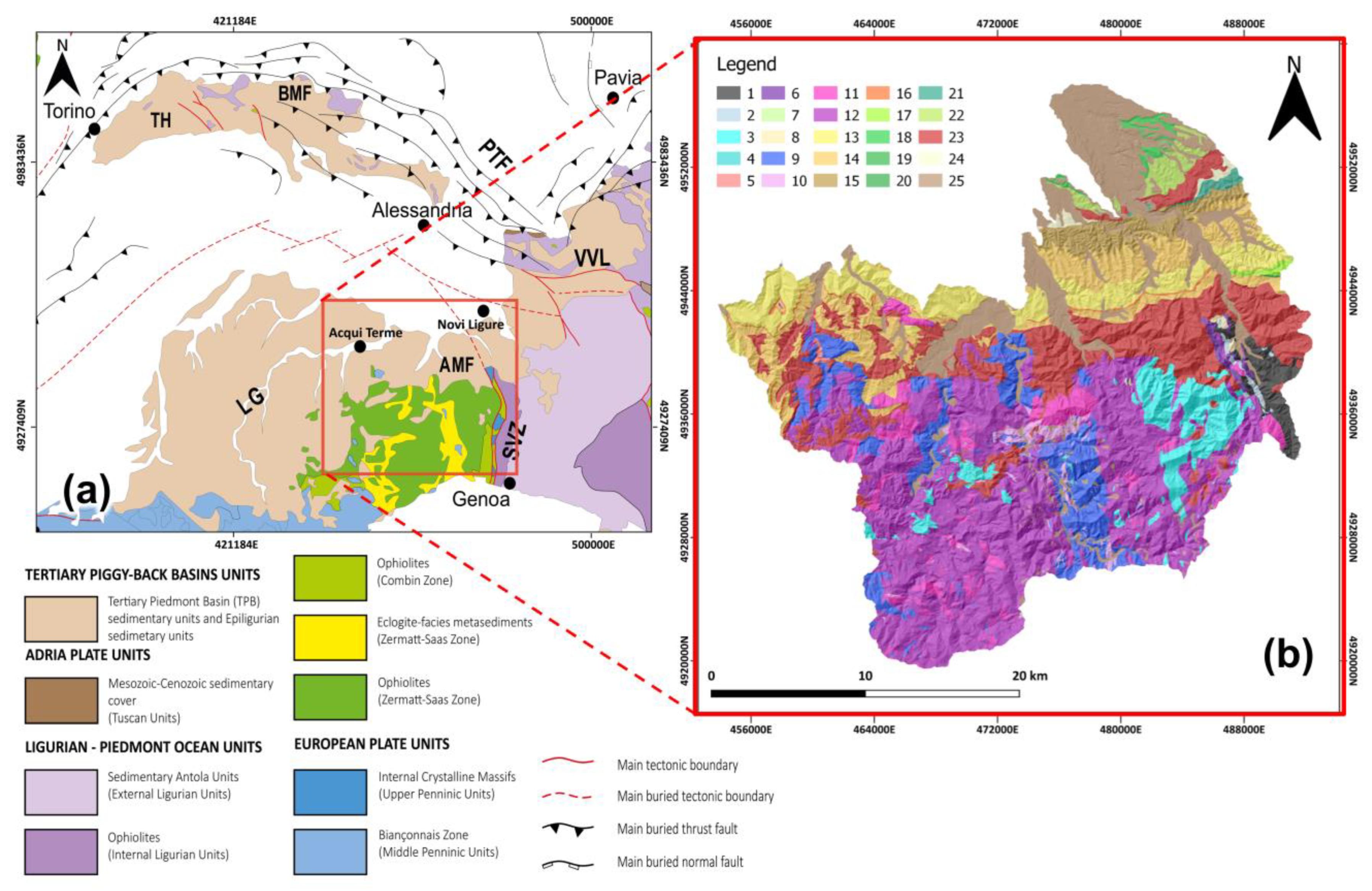
2. Study Area
2.1. Geomorphological and Geological Setting
2.2. Pluviometric Setting and Rainfall 2019 Events
2.3. Rainfall-Induced Landslides
3. Materials and Methods
3.1. Rainfall Dataset
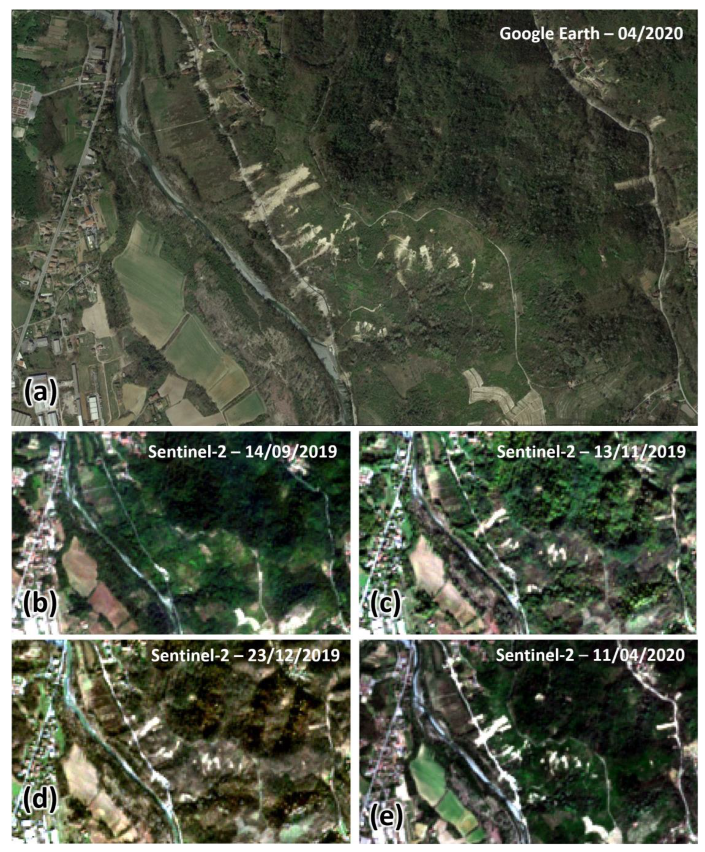
3.2. Landslide Inventory
- They were triggered by a single accumulation of seasonal precipitation during the October–November period.
- They displayed clearly identifiable crowns, flanks, and main scarps and/or main bodies through satellite imagery.
- They were in an initial state of activation.
- They exhibited velocity rates ranging from m/min to m/s, classified as “rapid” and “very rapid” movements [50].
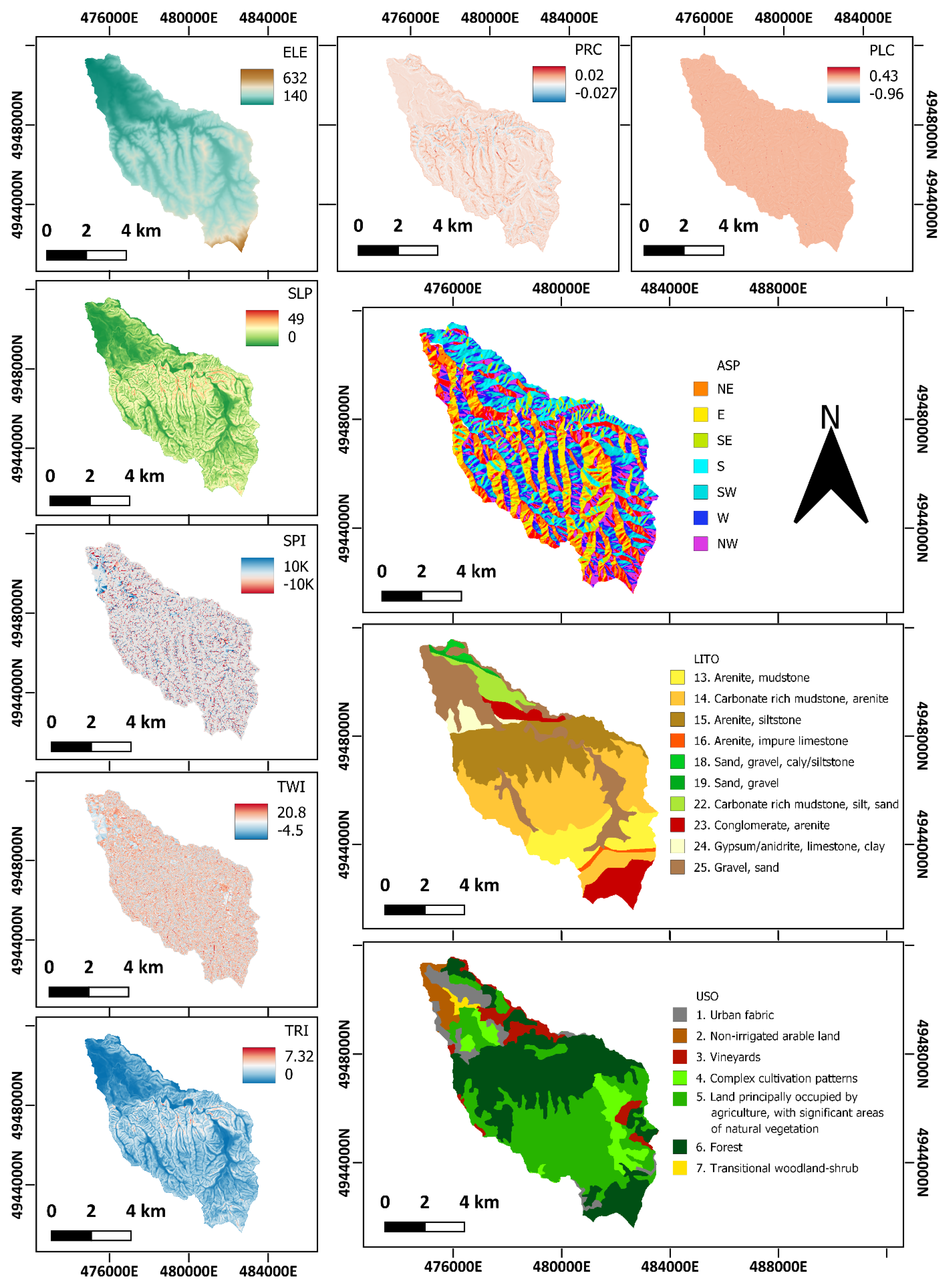
3.3. Landslide Susceptibility Model
4. Results
4.1. Rainfall Analysis Results
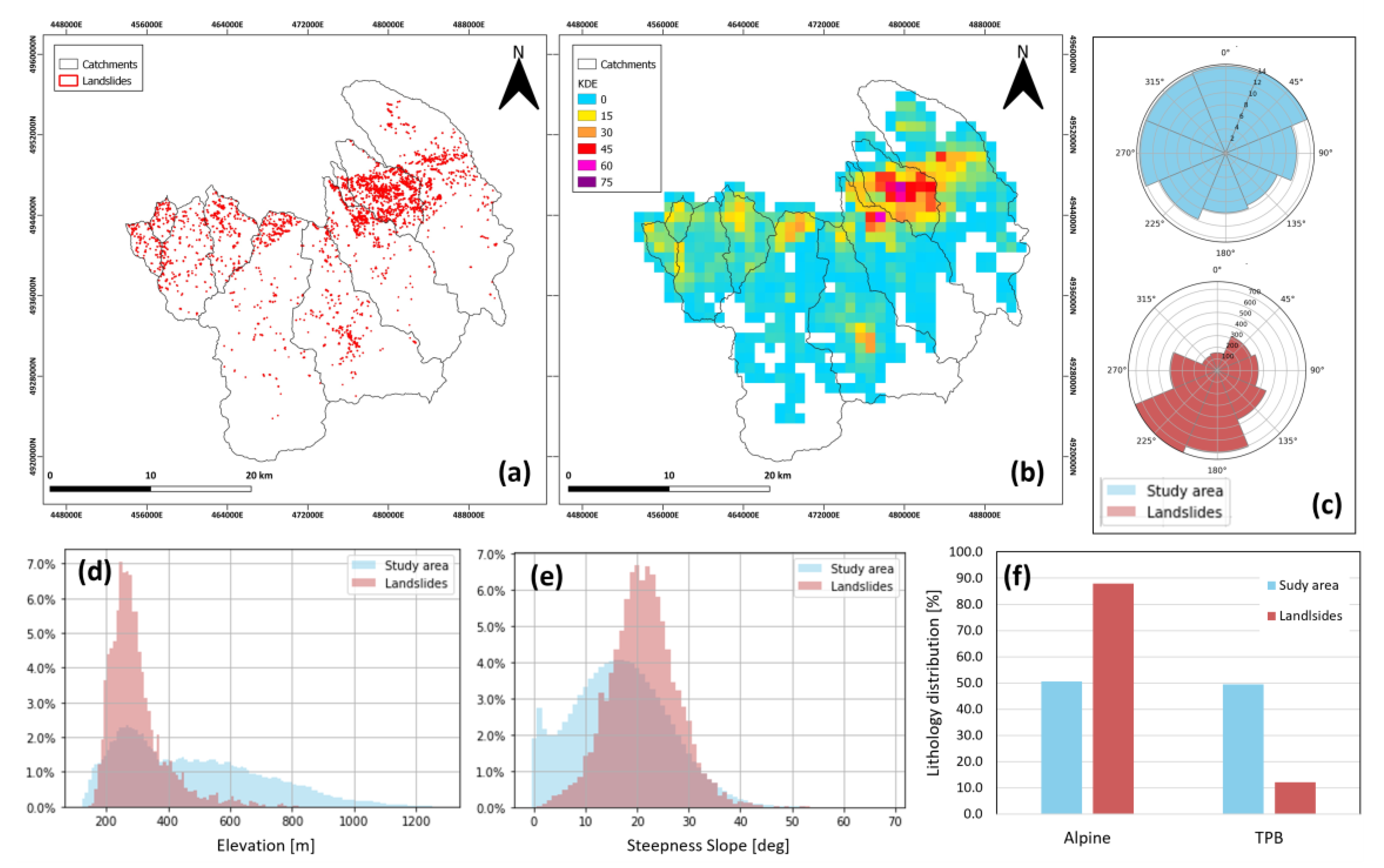
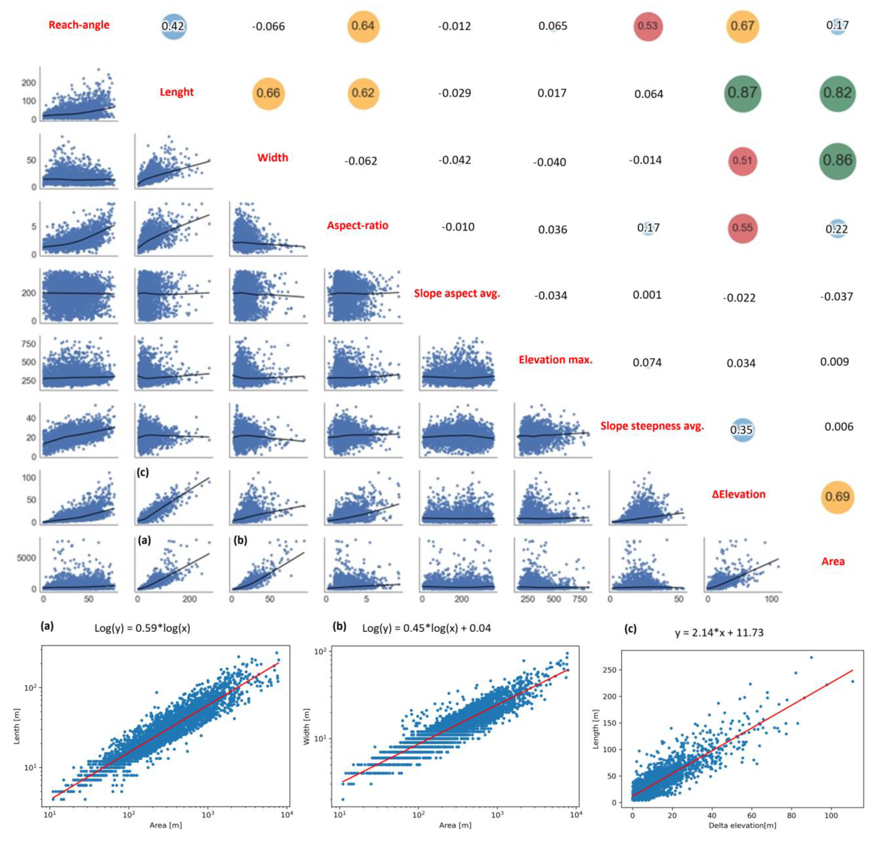
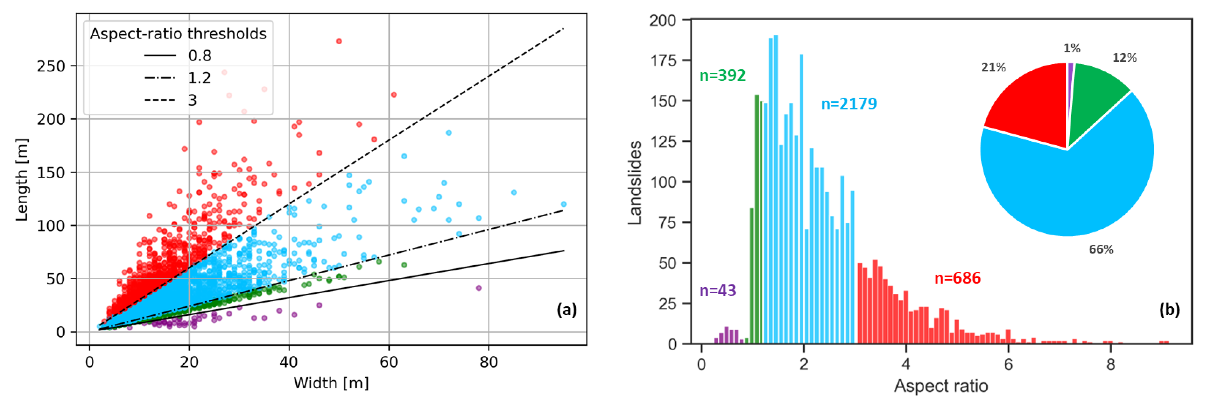
4.2. Landslide Inventory
4.3. Landslide Susceptibility Model
5. Discussion
6. Conclusions
Author Contributions
Funding
Conflicts of Interest
Appendix A


References
- Peel, M.C.; Finlayson, B.L.; McMahon, T.A. Updated World Map of the Köppen-Geiger Climate Classification. Hydrol. Earth Syst. Sci. 2007, 11, 1633–1644. [Google Scholar] [CrossRef]
- Galli, M.; Ardizzone, F.; Cardinali, M.; Guzzetti, F.; Reichenbach, P. Comparing Landslide Inventory Maps. Geomorphology 2008, 94, 268–289. [Google Scholar] [CrossRef]
- Gullà, G.; Conforti, M.; Borrelli, L. A Refinement Analysis of the Shallow Landslides Susceptibility at Regional Scale Supported by GIS-Aided Geo-Database. Geomat. Nat. Hazards Risk 2021, 12, 2500–2543. [Google Scholar] [CrossRef]
- Arpa Piemonte—Evento 22, 25 Novembre 2019. Available online: http://www.arpa.piemonte.it/pubblicazioni-2/relazioni-tecniche/analisi-eventi/ (accessed on 18 July 2023).
- Arpa Piemonte—Evento 19, 24 Ottobre 2019. Available online: http://www.arpa.piemonte.it/pubblicazioni-2/relazioni-tecniche/analisi-eventi/eventi2019/ (accessed on 18 July 2023).
- Lombardo, L.; Cama, M.; Conoscenti, C.; Märker, M.; Rotigliano, E. Binary Logistic Regression versus Stochastic Gradient Boosted Decision Trees in Assessing Landslide Susceptibility for Multiple-Occurring Landslide Events: Application to the 2009 Storm Event in Messina (Sicily, Southern Italy). Nat. Hazards 2015, 79, 1621–1648. [Google Scholar] [CrossRef]
- Felicísimo, Á.M.; Cuartero, A.; Remondo, J.; Quirós, E. Mapping Landslide Susceptibility with Logistic Regression, Multiple Adaptive Regression Splines, Classification and Regression Trees, and Maximum Entropy Methods: A Comparative Study. Landslides 2013, 10, 175–189. [Google Scholar] [CrossRef]
- Martinello, C.; Cappadonia, C.; Rotigliano, E. Investigating the Effects of Cell Size in Statistical Landslide Susceptibility Modelling for Different Landslide Typologies: A Test in Central–Northern Sicily. Appl. Sci. 2023, 13, 1145. [Google Scholar] [CrossRef]
- Harp, E.L.; Keefer, D.K.; Sato, H.P.; Yagi, H. Landslide Inventories: The Essential Part of Seismic Landslide Hazard Analyses. Eng. Geol. 2011, 122, 9–21. [Google Scholar] [CrossRef]
- Taylor, F.E.; Malamud, B.D.; Witt, A.; Guzzetti, F. Landslide Shape, Ellipticity and Length-to-Width Ratios: What Shape Is a Landslide? Earth Surf. Process. Landforms 2018, 43, 3164–3189. [Google Scholar] [CrossRef]
- Sahrane, R.; Bounab, A.; El Kharim, Y. Investigating the Effects of Landslides Inventory Completeness on Susceptibility Mapping and Frequency-Area Distributions: Case of Taounate Province, Northern Morocco. CATENA 2023, 220, 106737. [Google Scholar] [CrossRef]
- Samodra, G.; Ngadisih, N.; Malawani, M.N.; Mardiatno, D.; Cahyadi, A.; Nugroho, F.S. Frequency–Magnitude of Landslides Affected by the 27–29 November 2017 Tropical Cyclone Cempaka in Pacitan, East Java. J. Mt. Sci. 2020, 17, 773–786. [Google Scholar] [CrossRef]
- Schlögel, R.; Malet, J.-P.; Reichenbach, P.; Remaître, A.; Doubre, C. Analysis of a Landslide Multi-Date Inventory in a Complex Mountain Landscape: The Ubaye Valley Case Study. Nat. Hazards Earth Syst. Sci. 2015, 15, 2369–2389. [Google Scholar] [CrossRef]
- Hurst, M.D.; Ellis, M.A.; Royse, K.R.; Lee, K.A.; Freeborough, K. Controls on the Magnitude-Frequency Scaling of an Inventory of Secular Landslides. Earth Surf. Dynam. 2013, 1, 67–78. [Google Scholar] [CrossRef]
- Regmi, N.R.; Giardino, J.R.; Vitek, J.D. Characteristics of Landslides in Western Colorado, USA. Landslides 2014, 11, 589–603. [Google Scholar] [CrossRef]
- Qiu, H.; Hu, S.; Yang, D.; He, Y.; Pei, Y.; Kamp, U. Comparing Landslide Size Probability Distribution at the Landscape Scale (Loess Plateau and the Qinba Mountains, Central China) Using Double Pareto and Inverse Gamma. Bull. Eng. Geol Environ. 2021, 80, 1035–1046. [Google Scholar] [CrossRef]
- Bhuyan, K.; Tanyaş, H.; Nava, L.; Puliero, S.; Meena, S.R.; Floris, M.; Van Westen, C.; Catani, F. Generating Multi-Temporal Landslide Inventories through a General Deep Transfer Learning Strategy Using HR EO Data. Sci. Rep. 2023, 13, 162. [Google Scholar] [CrossRef] [PubMed]
- Maki Mateso, J.-C.; Bielders, C.L.; Monsieurs, E.; Depicker, A.; Smets, B.; Tambala, T.; Bagalwa Mateso, L.; Dewitte, O. Characteristics and Causes of Natural and Human-Induced Landslides in a Tropical Mountainous Region: The Rift Flank West of Lake Kivu (Democratic Republic of the Congo). Nat. Hazards Earth Syst. Sci. 2023, 23, 643–666. [Google Scholar] [CrossRef]
- Tanyaş, H.; Görüm, T.; Kirschbaum, D.; Lombardo, L. Could Road Constructions Be More Hazardous than an Earthquake in Terms of Mass Movement? Nat. Hazards 2022, 112, 639–663. [Google Scholar] [CrossRef]
- Lombardo, L.; Mai, P.M. Presenting Logistic Regression-Based Landslide Susceptibility Results. Eng. Geol. 2018, 244, 14–24. [Google Scholar] [CrossRef]
- Capponi, G.; Crispini, L. Note Illustrative del Foglio 213 e 230 «Genova» Della Carta Geologica D’Italia Alla Scala 1:50.000.; APAT—Servizio Geologico d’Italia: Firenze, Italy, 2008. [Google Scholar]
- Luino, F. Sequence of Instability Processes Triggered by Heavy Rainfall in the Northern Italy. Geomorphology 2005, 66, 13–39. [Google Scholar] [CrossRef]
- Ghibaudo, G.; Clari, P.; Perello, M. Litostratigrafia, Sedimentologia Ed Evoluzione Tettonico-Sedimentaria Dei Depositi Miocenici Del Margine Sud-Orientale Del Bacino Terziario Ligure-Piemontese (Valli Borbera, Scrivia e Lemme). Boll. Della Soc. Geol. Ital. 1985, 104, 349–397. [Google Scholar]
- Piana, F.; Fioraso, G.; Irace, A.; Mosca, P.; d’Atri, A.; Barale, L.; Falletti, P.; Monegato, G.; Morelli, M.; Tallone, S.; et al. Geology of Piemonte Region (NW Italy, Alps–Apennines Interference Zone). J. Maps 2017, 13, 395–405. [Google Scholar] [CrossRef]
- Federico, L.; Crispini, L.; Vigo, A.; Capponi, G. Unravelling Polyphase Brittle Tectonics through Multi-Software Fault-Slip Analysis: The Case of the Voltri Unit, Western Alps (Italy). J. Struct. Geol. 2014, 68, 175–193. [Google Scholar] [CrossRef]
- Molli, G.; Crispini, L.; Malusà, M.G.; Mosca, P.; Piana, F.; Federico, L. Geology of the Western Alps-Northern Apennine Junction Area: A Regional Review. J. Virtual Explor. 2010, 36, 9. [Google Scholar] [CrossRef]
- Ford, M.; Duchêne, S.; Gasquet, D.; Vanderhaeghe, O. Two-Phase Orogenic Convergence in the External and Internal SW Alps. J. Geol. Soc. 2006, 163, 815–826. [Google Scholar] [CrossRef]
- Castellarin, A. Alps-Apennines and Po Plain-Frontal Apennines Relations. In Anatomy of an Orogen: The Apennines and Adjacent Mediterranean Basins; Vai, G.B., Martini, I.P., Eds.; Springer: Dordrecht, The Netherlands, 2001; pp. 177–195. ISBN 978-90-481-4020-6. [Google Scholar]
- Bigi, G.; Castellarin, A.; Coli, M.; Dal Piaz, G.V.; Sortori, R.; Scandone, P.; Vai, G.B. Structural Model of Italy, Sheets 1-2: CNR, Progetto Fin. Geodinamica; SELCA: Firenze, Italy, 1990. [Google Scholar]
- Balestro, G.; Festa, A.; Dilek, Y.; Tartarotti, P. Pre-Alpine Extensional Tectonics of a Peridotitelocalized Oceanic Core Complex in the Late Jurassic, High-Pressure Monviso Ophiolite (Western Alps). Episodes 2015, 38, 266–282. [Google Scholar] [CrossRef]
- Mosca, P.; Polino, R.; Rogledi, S.; Rossi, M. New Data for the Kinematic Interpretation of the Alps–Apennines Junction (Northwestern Italy). Int. J. Earth Sci. 2010, 99, 833–849. [Google Scholar] [CrossRef]
- Rossi, M.; Mosca, P.; Polino, R.; Rogledi, S.; Biffi, U. New Outcrop and Subsurface Data in the Tertiary Piedmont Basin (NW-Italy): Unconformity-Bounded Stratigraphic Units and Their Relationships with Basin-Modification Phases. Riv. Ital. Paleontol. Stratigr. 2009, 115, 305–335. [Google Scholar]
- Gelati, R.; Gnaccolini, M. Synsedimentary Tectonics and Sedimentation in the Tertiary Piedmont Basin, Northwestern Italy. Riv. Ital. Paleontol. Stratigr. 1998, 104, 193–214. [Google Scholar]
- d’Atri, A.; Irace, A.; Piana, F.; Tallone, S.; Varrone, D.; Bellino, L.; Fioraso, G.; Cadoppi, P.; Fusetti, E.; Morelli, M.; et al. Note Illustrative Della Carta Geologica d’Italia Alla Scala 1:50,000, Foglio 194, Acqui Terme; ISPRA, Istituto Superiore per La Protezione e La Ricerca Ambientale: Roma, Italy, 2014. [Google Scholar]
- Baronetti, A.; Acquaotta, F.; Fratianni, S. Rainfall Variability from a Dense Rain Gauge Network in North-Western Italy. Clim. Res. 2018, 75, 201–213. [Google Scholar] [CrossRef]
- Arpa Dati Meteoidrografici. Available online: https://www.arpa.piemonte.it/dati-ambientali/dati-meteoidrografici-giornalieri-richiesta-automatica (accessed on 18 July 2023).
- Arpa Liguria Dati Meteoidrografici. Available online: https://omirl.regione.liguria.it/#/map (accessed on 18 July 2023).
- Sistema Piemonte RAM. Available online: http://www.sistemapiemonte.it/fedwcodagt/centralineDB.jsp (accessed on 18 July 2023).
- Acquaotta, F.; Fratianni, S.; Venema, V. Assessment of Parallel Precipitation Measurements Networks in Piedmont, Italy. Int. J. Climatol. 2016, 36, 3963–3974. [Google Scholar] [CrossRef]
- Hattermann, F.F.; Wattenbach, M.; Krysanova, V.; Wechsung, F. Runoff Simulations on the Macroscale with the Ecohydrological Model SWIM in the Elbe Catchment-Validation and Uncertainty Analysis. Hydrol. Process. 2005, 19, 693–714. [Google Scholar] [CrossRef]
- Buytaert, W.; Celleri, R.; Willems, P.; Bièvre, B.D.; Wyseure, G. Spatial and Temporal Rainfall Variability in Mountainous Areas: A Case Study from the South Ecuadorian Andes. J. Hydrol. 2006, 329, 413–421. [Google Scholar] [CrossRef]
- Berezowski, T.; Szcześniak, M.; Kardel, I.; Michałowski, R.; Okruszko, T.; Mezghani, A.; Piniewski, M. CPLFD-GDPT5: High-Resolution Gridded Daily Precipitation and Temperature Data Set for Two Largest Polish River Basins. Earth Syst. Sci. Data 2016, 8, 127–139. [Google Scholar] [CrossRef]
- Brinckmann, S.; Krähenmann, S.; Bissolli, P. High-Resolution Daily Gridded Data Sets of Air Temperature and Wind Speed for Europe. Earth Syst. Sci. Data 2016, 8, 491–516. [Google Scholar] [CrossRef]
- Frazier, A.G.; Giambelluca, T.W. Spatial Trend Analysis of Hawaiian Rainfall from 1920 to 2012. Int. J. Climatol. 2017, 37, 2522–2531. [Google Scholar] [CrossRef]
- Lucas, M.P.; Longman, R.J.; Giambelluca, T.W.; Frazier, A.G.; Mclean, J.; Cleveland, S.B.; Huang, Y.-F.; Lee, J. Optimizing Automated Kriging to Improve Spatial Interpolation of Monthly Rainfall over Complex Terrain. J. Hydrometeorol. 2022, 23, 561–572. [Google Scholar] [CrossRef]
- Pereira, G.W.; Valente, D.S.M.; Queiroz, D.M.D.; Coelho, A.L.D.F.; Costa, M.M.; Grift, T. Smart-Map: An Open-Source QGIS Plugin for Digital Mapping Using Machine Learning Techniques and Ordinary Kriging. Agronomy 2022, 12, 1350. [Google Scholar] [CrossRef]
- Isaaks, E.H.; Srivastava, R.M. An Introduction to Applied Geostatistics; Oxford University Press: New York, NY, USA, 1989; ISBN 0-19-505012-6. [Google Scholar]
- Shuttle Radar Topography Mission. Available online: https://www2.jpl.nasa.gov/srtm/ (accessed on 18 July 2023).
- Sentinel-2 Mission. Available online: https://sentinel.esa.int/web/sentinel/missions/sentinel-2 (accessed on 18 July 2023).
- Cruden, D.M.; Varnes, D.J. Landslide Types and Processes; Transportation Research Board; U.S. National Academy of Sciences: Washington, DC, USA, 1996; pp. 36–75. [Google Scholar]
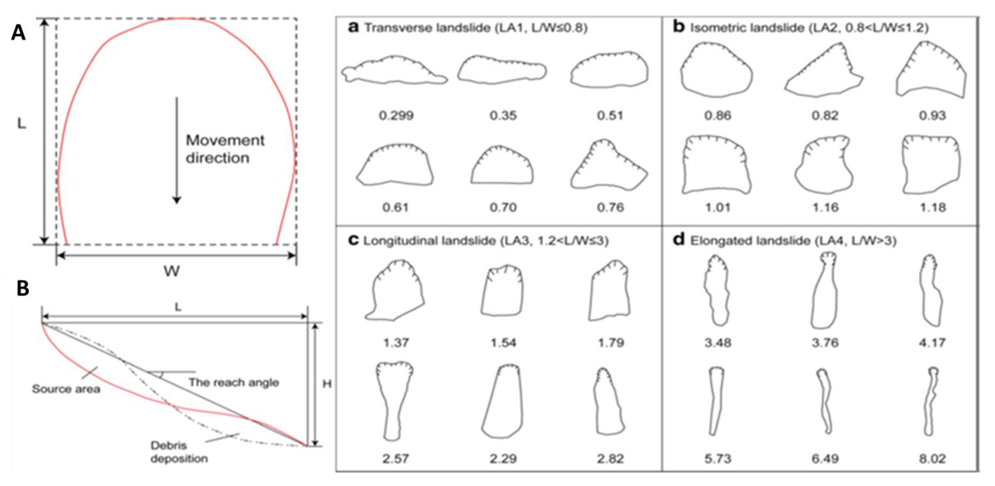
- Li, L.; Lan, H.; Strom, A.; Macciotta, R. Landslide Length, Width, and Aspect Ratio: Path-Dependent Measurement and a Revisit of Nomenclature. Landslides 2022, 19, 3009–3029. [Google Scholar] [CrossRef]
- IAEG Commission on Landslides. Suggested Nomenclature for Landslides. Bull. Int. Assoc. Eng. Geol. 1990, 41, 13–16. [Google Scholar] [CrossRef]
- Tian, Y.; Xu, C.; Chen, J.; Zhou, Q.; Shen, L. Geometrical Characteristics of Earthquake-Induced Landslides and Correlations with Control Factors: A Case Study of the 2013 Minxian, Gansu, China, Mw 5.9 Event. Landslides 2017, 14, 1915–1927. [Google Scholar] [CrossRef]
- Stark, C.P.; Hovius, N. The Characterization of Landslide Size Distribution. Geophys. Res. Lett. 2001, 28, 1091–1094. [Google Scholar] [CrossRef]
- Tebbens, S.F. Landslide Scaling: A Review. Earth Space Sci. 2020, 7, e2019EA000662. [Google Scholar] [CrossRef]
- Van Den Eeckhaut, M.; Reichenbach, P.; Guzzetti, F.; Rossi, M.; Poesen, J. Combined Landslide Inventory and Susceptibility Assessment Based on Different Mapping Units: An Example from the Flemish Ardennes, Belgium. Nat. Hazards Earth Syst. Sci. 2009, 9, 507–521. [Google Scholar] [CrossRef]
- Erener, A.; Düzgün, H.S.B. Landslide Susceptibility Assessment: What Are the Effects of Mapping Unit and Mapping Method? Environ. Earth Sci. 2012, 66, 859–877. [Google Scholar] [CrossRef]
- Rotigliano, E.; Cappadonia, C.; Conoscenti, C.; Costanzo, D.; Agnesi, V. Slope Units-Based Flow Susceptibility Model: Using Validation Tests to Select Controlling Factors. Nat. Hazards 2012, 61, 143–153. [Google Scholar] [CrossRef]
- Ba, Q.; Chen, Y.; Deng, S.; Yang, J.; Li, H. A Comparison of Slope Units and Grid Cells as Mapping Units for Landslide Susceptibility Assessment. Earth Sci. Inform. 2018, 11, 373–388. [Google Scholar] [CrossRef]
- Bornaetxea, T.; Rossi, M.; Marchesini, I.; Alvioli, M. Effective Surveyed Area and Its Role in Statistical Landslide Susceptibility Assessments. Nat. Hazards Earth Syst. Sci. 2018, 18, 2455–2469. [Google Scholar] [CrossRef]
- Domènech, G.; Alvioli, M.; Corominas, J. Preparing First-Time Slope Failures Hazard Maps: From Pixel-Based to Slope Unit-Based. Landslides 2020, 17, 249–265. [Google Scholar] [CrossRef]
- Martinello, C.; Cappadonia, C.; Conoscenti, C.; Agnesi, V.; Rotigliano, E. Optimal Slope Units Partitioning in Landslide Susceptibility Mapping. J. Maps 2021, 17, 152–162. [Google Scholar] [CrossRef]
- Carrara, A.; Cardinali, M.; Guzzetti, F.; Reichenbach, P. Gis Technology in Mapping Landslide Hazard. In Geographical Information Systems in Assessing Natural Hazards; Carrara, A., Guzzetti, F., Eds.; Advances in Natural and Technological Hazards Research; Springer: Dordrecht, The Netherlands, 1995; Volume 5, pp. 135–175. ISBN 978-90-481-4561-4. [Google Scholar]
- Guzzetti, F.; Reichenbach, P.; Cardinali, M.; Galli, M.; Ardizzone, F. Probabilistic Landslide Hazard Assessment at the Basin Scale. Geomorphology 2005, 72, 272–299. [Google Scholar] [CrossRef]
- Costanzo, D.; Rotigliano, E.; Irigaray, C.; Jiménez-Perálvarez, J.D.; Chacón, J. Factors Selection in Landslide Susceptibility Modelling on Large Scale Following the Gis Matrix Method: Application to the River Beiro Basin (Spain). Nat. Hazards Earth Syst. Sci. 2012, 12, 327–340. [Google Scholar] [CrossRef]
- Amato, G.; Eisank, C.; Castro-Camilo, D.; Lombardo, L. Accounting for Covariate Distributions in Slope-Unit-Based Landslide Susceptibility Models. A Case Study in the Alpine Environment. Eng. Geol. 2019, 260, 105237. [Google Scholar] [CrossRef]
- Tarquini, S.; Vinci, S.; Favalli, M.; Doumaz, F.; Fornaciai, A.; Nannipieri, L. Release of a 10-m-Resolution DEM for the Italian Territory: Comparison with Global-Coverage DEMs and Anaglyph-Mode Exploration via the Web. Comput. Geosci. 2012, 38, 168–170. [Google Scholar] [CrossRef]
- Conrad, O.; Bechtel, B.; Bock, M.; Dietrich, H.; Fischer, E.; Gerlitz, L.; Wehberg, J.; Wichmann, V.; Böhner, J. System for Automated Geoscientific Analyses (SAGA) v. 2.1.4. Geosci. Model Dev. 2015, 8, 1991–2007. [Google Scholar] [CrossRef]
- Lombardo, L.; Cama, M.; Maerker, M.; Rotigliano, E. A Test of Transferability for Landslides Susceptibility Models under Extreme Climatic Events: Application to the Messina 2009 Disaster. Nat. Hazards 2014, 74, 1951–1989. [Google Scholar] [CrossRef]
- Esposito, C.; Mastrantoni, G.; Marmoni, G.M.; Antonielli, B.; Caprari, P.; Pica, A.; Schilirò, L.; Mazzanti, P.; Bozzano, F. From Theory to Practice: Optimisation of Available Information for Landslide Hazard Assessment in Rome Relying on Official, Fragmented Data Sources. Landslides 2023, 20, 2055–2073. [Google Scholar] [CrossRef]
- Naimi, B. R-GIS. Available online: https://r-gis.net/ (accessed on 18 July 2023).
- Zuur, A.F.; Ieno, E.N.; Walker, N.J.; Saveliev, A.A.; Smith, G.M. GLM and GAM for Absence–Presence and Proportional Data. In Mixed Effects Models and Extensions in Ecology with R; Statistics for Biology and Health; Springer New York: New York, NY, USA, 2009; pp. 245–259. ISBN 978-0-387-87457-9. [Google Scholar]
- Conoscenti, C.; Ciaccio, M.; Caraballo-Arias, N.A.; Gómez-Gutiérrez, Á.; Rotigliano, E.; Agnesi, V. Assessment of Susceptibility to Earth-Flow Landslide Using Logistic Regression and Multivariate Adaptive Regression Splines: A Case of the Belice River Basin (Western Sicily, Italy). Geomorphology 2015, 242, 49–64. [Google Scholar] [CrossRef]
- Trigila, A.; Iadanza, C.; Esposito, C.; Scarascia-Mugnozza, G. Comparison of Logistic Regression and Random Forests Techniques for Shallow Landslide Susceptibility Assessment in Giampilieri (NE Sicily, Italy). Geomorphology 2015, 249, 119–136. [Google Scholar] [CrossRef]
- Reichenbach, P.; Rossi, M.; Malamud, B.D.; Mihir, M.; Guzzetti, F. A Review of Statistically-Based Landslide Susceptibility Models. Earth-Sci. Rev. 2018, 180, 60–91. [Google Scholar] [CrossRef]
- Hosmer, D.; Lemeshow, S. Stepwise Logistic Regression. Applied Logistic Regression. In Chapter 4, Model-building Strategies and Methods for Logistic Regression; John Wiley & Sons: Hoboken, NJ, USA, 2013; pp. 116–121. [Google Scholar]
- Hartmann, K.; Krois, J.; Rudolph, A. Statistics and Geodata Analysis Using R (SOGA-R); Department of Earth Sciences, Freie Universitaet Berlin. Available online: https://www.geo.fu-berlin.de/en/v/soga-r/index.html (accessed on 18 July 2023).
- R Core Team. Available online: http://www.r-project.org/index.html (accessed on 18 July 2023).
- Youden, W.J. Index for Rating Diagnostic Tests. Cancer 1950, 3, 32–35. [Google Scholar] [CrossRef]


| N | Imagery Criterion | Strategies Adopted |
|---|---|---|
| 1 | The imagery must be continuous in space and time in the entire area to span the landslides’ distribution triggered by the same event. | GEP and S2 satellite images covering all the area for the period considered in this research. |
| 2 | The imagery must have a resolution that allows identification of individual landslides as small as a few meters across. | In the area considered for this research, GEP provided very high-pixel resolution imagery. |
| 3 | The imagery must have stereo coverage or be able to be draped over a digital elevation model to obtain a stereo-like perspective view. | GEP 2.5D viewer provides a stereo-like perspective view. |
| 4 | The imagery must be as cloud-free and shadow-free as possible. | GEP images are elaborated to be cloud free. As for the S2 image, it is possible to select the maximum cloud-coverage |
| 5 | The imagery must be acquired as soon as possible after the triggering event to capture the initial features of the landslides and the terrain or infrastructure that they affect. | The GEP images available: pre-events and postevents. The S2 images available (according to the 4th criterion) were pre-events, between the events, and post-events. |
| N | Mapping Criterion | Strategies Adopted |
|---|---|---|
| 1 | The landslides must be defined as polygons in a GIS system, either as a single polygon representing the entire landslide or as two or more polygons that define the landslide source and the landslide deposit. | Single polygon and derivatives. |
| 2 | The landslide polygons must be plotted on a topographic map or GIS layer that is registered to a topographic map or geo-registered image. | QGIS Geodatabase. |
| 3 | The entire population of the event’s triggered landslides exceeding the minimum resolution of the imagery must be mapped. | Frequency–Area analysis. |
| Parameter | Elevation [m] | Slope Steepness [°] | Slope Aspect [°] | Area [m2] |
|---|---|---|---|---|
| min | 148 | 1.95 | 3 | 11 |
| max | 825 | 53.48 | 360 | 7875 |
| std | 90 | 6.48 | 80 | 690 |
| median | 281 | 21.56 | 207 | 280 |
Disclaimer/Publisher’s Note: The statements, opinions and data contained in all publications are solely those of the individual author(s) and contributor(s) and not of MDPI and/or the editor(s). MDPI and/or the editor(s) disclaim responsibility for any injury to people or property resulting from any ideas, methods, instructions or products referred to in the content. |
© 2023 by the authors. Licensee MDPI, Basel, Switzerland. This article is an open access article distributed under the terms and conditions of the Creative Commons Attribution (CC BY) license (https://creativecommons.org/licenses/by/4.0/).
Share and Cite
Licata, M.; Buleo Tebar, V.; Seitone, F.; Fubelli, G. The Open Landslide Project (OLP), a New Inventory of Shallow Landslides for Susceptibility Models: The Autumn 2019 Extreme Rainfall Event in the Langhe-Monferrato Region (Northwestern Italy). Geosciences 2023, 13, 289. https://0-doi-org.brum.beds.ac.uk/10.3390/geosciences13100289
Licata M, Buleo Tebar V, Seitone F, Fubelli G. The Open Landslide Project (OLP), a New Inventory of Shallow Landslides for Susceptibility Models: The Autumn 2019 Extreme Rainfall Event in the Langhe-Monferrato Region (Northwestern Italy). Geosciences. 2023; 13(10):289. https://0-doi-org.brum.beds.ac.uk/10.3390/geosciences13100289
Chicago/Turabian StyleLicata, Michele, Victor Buleo Tebar, Francesco Seitone, and Giandomenico Fubelli. 2023. "The Open Landslide Project (OLP), a New Inventory of Shallow Landslides for Susceptibility Models: The Autumn 2019 Extreme Rainfall Event in the Langhe-Monferrato Region (Northwestern Italy)" Geosciences 13, no. 10: 289. https://0-doi-org.brum.beds.ac.uk/10.3390/geosciences13100289