Review

Development of a Preliminary-Risk-Based Flood Management Approach to Address the Spatiotemporal Distribution of Risk under the Kaldor–Hicks Compensation Principle

by
Muhammad Atiq Ur Rehman Tariq
1,2,*,
Rashid Farooq
3,4 and
Nick van de Giesen
5,*
1
College of Engineering & Science, Victoria University, Melbourne, VIC 8001, Australia
2
Institute for Sustainable Industries & Livable Cities, Victoria University, P.O. Box 14428, Melbourne, VIC 8001, Australia
3
Department of Civil Engineering, International Islamic University, Islamabad 44000, Pakistan
4
Department of Civil Engineering, Lakehead University, Thunder Bay, ON P7B 5E1, Canada
5
Water Resources Management Section, Faculty of Civil Engineering and Geosciences, Delft University of Technology, 2600 GA Delft, The Netherlands
*
Authors to whom correspondence should be addressed.
Submission received: 8 November 2020 / Revised: 7 December 2020 / Accepted: 14 December 2020 / Published: 17 December 2020

Abstract

:
All over the world, probability-based flood protection designs are the ones most commonly used. Different return-period design floods are standard criteria for designing structural measures. Recently, risk-based flood management has received a significant appraisal, but the fixed return period is still the de facto standard for flood management designs due to the absence of a robust framework for risk-based flood management. The objective of this paper is to discuss the economics and criteria of project appraisal, as well as to recommend the most suitable approach for a risk-based project feasibility evaluation. When it comes to flood management, decision-makers, who are generally politicians, have to prioritize the allocation of resources to different civic welfare projects. This research provides a connection between engineering, economics, and management. Taking account of socioeconomic and environmental constraints, several measures can be employed in a floodplain. The Kaldor–Hicks compensation principle provides the basis for a risk-based feasibility analysis. Floods should be managed in a way that reduces the damage from minimum investments to ensure maximum output from floodplain land use. Specifically, marginal losses due to flood damage and the expense of flood management must be minimized. This point of minimum expenses is known as the “optimum risk point” or “optimal state”. This optimal state can be estimated using a risk-based assessment. Internal rate of return, net present value, and benefit–cost ratio are indicators that describe the feasibility of a project. However, considering expected annual damage is strongly recommended for flood management to ensure a simultaneous envisage of the performance of land-use practices and flood measures. Flood management ratios can be used to describe the current ratio of expected annual damage to the expected annual damage at the optimal risk point. Further development of the approach may replace probability-based standards at the national level.

1. Introduction

Some research studies support the notion that the severity and frequency of floods have increased in recent years [1]. Flood situations are likely to worsen due to climate change, land subsidence, urbanization, and population growth. Floods will become more frequent, prevalent, and serious in the future due to demography, lifestyle, and climate trends [2]. Greater flood damage demands an effective decision-making system for flood management and makes a revision of existing strategies a priority. Apollonio, C. et al. [3] emphasized a detailed economic analysis of flood events before the decision-makers deploy flood mitigation options.
As to flooding, it is not a new issue, and neither are the solutions being proposed. However, with the ever-increasing awareness of environmental concerns, living standards, and evolved technical expertise, the expectations of having a more efficient flood management approach is natural and justifiable. As a result, several flood management options, theories, approaches, measures, plans, and strategies are emerging. Some examples are flood protection, evacuation, environmentally friendly solutions, renaturalization of rivers, foolproof structural measures, nonstructural measures, soft measures, hard measures, room for the river, flood fighting, the resilient approach, sustainable flood management, the integrated approach, risk-based flood management, living with floods, nature-based solutions, economical solutions, spatial planning modifications, flood risk zoning, coping with floods, floodplain restoration, the no-adverse-impact approach, catchment management, community cooperation, compensation, dikes, floodwalls, warning systems, encroachment control, flood insurance, floodproofing, flow diversion, groundwater recharge, public awareness, relief efforts, river improvement, storage and retention, and sustainable drainage systems.
Flood management practices have evolved on the basis of the severity of floods and the socioeconomic aspects of a region. A single solution cannot be extended to all flood situations because the situations are not the same everywhere [4]. Climate variability, land use, and land cover are among the significant parameters affecting the regime of flooding [5]. Solutions have to be determined by the socioeconomic aspects of a country and flood behavior [6]. However, probability-based flood design prevails worldwide. For example, the 1/100-year flood is the de facto flood risk management norm in the US [7,8,9]. The 1/100-year flood is considered the base-flood for all structural and nonstructural designs. The UK’s typical design tolerance for urban areas is 1% and 0.5% probability of floods [10,11]. The Netherlands protects its population by 53 dike rings with a design probability of 1/1250 for river floods and up to 1/10,000 probability for the coasts of South Holland [12,13]. Flood safety standards along the coast are based on a 100-year flood return period in Germany and Austria [14]. Flood protection safety standards along the main courses of rivers differ greatly and range from 1/30 years to 1/1000 years along the upper Rhine [15]. In France, only one return period is calculated for flood hazards [16]. A 100-year flood is a widely accepted design standard for flood protection measures in many parts of the world [17].
Risk-based assessment methods were introduced during the 1990s in the field of flood management, and they provide a clear focus on flood impacts and the reduction of all possible flood-related risks [18]. However, three decades on, the probability-based flood protection design has become predominant due to the absence of rigid and well-modeled risk-based flood management design criteria. Other than the differences in development approaches and design criteria, the associated regulations and guidelines are not uniform for risk-based flood management throughout the world.

1.1. Research Questions

Decision-makers face the following questions when choosing their flood options and deciding on the extent to which resources will be deployed for flood management while bearing in mind other civic welfare priorities:
  • How many types of resources need to be deployed for flood management while there are also other priorities of civic welfare public works?
  • How can the best value of resources be obtained in a floodplain, including the cost of land-use practices and flood management measures?
The research presented in this manuscript addresses the fundamental questions facing decision-makers when choosing flood management measures. The article lays out a provisional risk-based approach based on the Kaldor–Hicks compensation principle to address the economic justifications of risk-based flood management.

1.2. Limitations and Scope

The research presented covers the development of a provisional basis for choosing appropriate flood management measures and the limits of financial resources for risk-based flood management options. The implementation strategies, technical designs, cost–benefit analyses, and discussions on possible flood management options are beyond the scope of this research. Floods take several forms: pluvial, fluvial, urban, flash, tidal, and dam breaks. However, for this research, only fluvial floods are considered for the development of a decision support system for flood management.

1.3. Flood Management Plans

Governments incur considerable expenditure in connection with plans for flood management. The intensity of flooding problems and resource availability govern the extent of resource allocation for flood projects. Flood management projects or plans are the practical steps of a flood management strategy consisting of one or more measures planned according to the nature of flood issues. Plans are transformed into projects using resources, while a combination of measures may be implemented throughout a strategy’s lifetime [19,20]. The following examples demonstrate different strategies:
  • Flood control/flood mitigation tends to limit flood distribution through structural measures.
  • The adjustment or modification of human activities to minimize flood losses is obtained by adaptation.
  • Flood management based on resilience is an approach that emphasizes structural floodplain operations to ensure that after a flood occurs, the system can recover.
  • Integrated flood management ensures that flood management is appropriately linked to other river functions and floodplain operations. There is multidisciplinary knowledge involved.
  • Sustainable flood management ensures that measures that will not cause serious complications in the future are chosen. A fair valuation of social, economic, and environmental assets is required for this approach.
  • The no adverse impact strategy considers plans that do not shift or increase flood hazards to neighboring floodplains or areas.
  • Floodplain restoration assumes that a natural floodplain has better flood-handling capacities.
The modern flood management concepts above have been evaluated over time. A brief history of different flood management eras will shed light on the development of the different concepts over time.

1.4. Four Generations of Flood Management

The first human response to floods or any natural hazard was to adapt. Human lifestyle and activities were adjusted to ensure minimum interference to waterways [6]. This indigenous era of flood adaptations started in the 19th century and included growing flood-resistant crops, relocating dwellings, and early embankments.
Growing urbanization and greater economic exposure in floodplains heralded the second generation of flood management, which was mainly characterized by structural measures to control and defend against floods. Flood control remained the dominant approach for the late 19th century and most of the 20th century. Initially, flood protection measures were designed to ensure that structures or measures must follow a minimum standard; this design approach was known as the element-design approach. For example, flood protection structures were designed in light of historical flood experiences [21,22]. Despite involving analyses of previous floods, they were not optimized in terms of a cost-to-benefit ratio. This approach is still taken in situations where high accuracy is not required [23]. However, the realization dawned that structures should be designed where there is a known probability of occurrence. As a result, probability-based safety standards were developed and implemented by prioritizing safety in the field of hazard and disaster management while controlling the return period of the flood [18]. A probability-based standard can be applied only when the risk falls below an arbitrary level, and these methods lack the ability to combat severe floods [4].
Although second-generation flood control was primarily an engineering approach, it produced more societal confidence in flood management. Nevertheless, there was a range of drawbacks, including growing exposure in a floodplain, detrimental environmental effects, and catastrophes once the flow exceeds the design flood. Initially, nonstructural measures were introduced to support the structural measures, but later on, the nonstructural possibilities were also presented as an alternative to conventional engineering solutions in the third generation of flood management. The main focus was on reducing the susceptibility to flooding or the exposure in the floodplain. Floodproofing, early warning systems, evacuation plans, public awareness, and flood zoning were introduced.
Substantial analyses of the strengths and failures of nonstructural approaches and the recurrence of severe and extremely devastating floods have culminated in a variety of strategies (rather than a single strategy) based on a more holistic approach (fourth generation) to address floods and the root causes of flooding [24]. The approach emphasizes the inclusion of all possible measures and adaptations at the catchment, river, and floodplain levels. Flood insurance and resilience capacities are recognized as flood management options. The involvement of multiple options at different stages of flood generation and flooding need criteria that would be capable of expressing the efficiencies of spending and the benefits thus obtained. Probability-based design standards failed to support the holistic approach. Risk-based assessment gained popularity due to its ability to assess and design measures under diverse situations and options. Risk-based criteria are also helpful when choosing the appropriate flood management strategy [25].

2. Risk Redistribution under the Kaldor–Hicks Compensation Principle

Holistic flood management involves a large-scale redistribution of flood risk over spatial and temporal frames. A risk-based assessment can evaluate and compare the outcomes, but the redistribution of risks involves different benefits and different losses. The Brownfield redevelopment principle is an example that combines different economic parameters under the concept of “enhancing public benefit” [26]. It is also true that the aim of all the standards developed so far is to evaluate the proportion of the costs and benefits of measures [27].
Losses/gains to small business setups involve small-scale studies, whereas such gains/losses might not be that important at a regional level due to redistributions of gains and losses to other small business setups. In this case, a business setup loses its production and another setup may have gains in its production to meet the market requirements. Thus, the loss to an individual is transferred in the shape of gains to another while having no impact at the regional level. The gains and losses of individual households, industries, or businesses are analyzed under “financial analysis”, whereas the macroeconomic effects at the regional level are covered under “economic analysis” [28]. Economic analysis is carried out to assess the feasibility of a flood management scheme. The Kaldor–Hicks compensation principle justifies redistribution and provides a criterion for combining the redistributed losses and benefits. The Kaldor–Hicks compensation principle states, “A redistribution of risk is efficient if it enables the gainers to compensate the losers, whether or not they do so” [29]. Flood management measures require significant resources, and sometimes, these measures just shift the flood spatially instead of suppressing the flooding. In such situations, just focusing on the loss reductions at a particular area of floodplain proves quite illusive. Kaldor proposed the principle of potential compensations in 1939. The main opposition that Kaldor faced about the principle was of an ethical nature, where marginal costs were ignored and the same weightage was given to all individuals. Hicks supported the proposed approach to aggregate welfare analysis proposed by Kaldor, which had benefits [30]. The Kaldor–Hicks compensation principle emphasizes the holistic consideration of all impacts. The principle of compensation provides for a rule that benefits (gains in human well-being) should exceed the cost (losses in human well-being) of projects or plans to be approved [29].
Structural measures are changing the pattern of floods. Such a shift of flow pattern brings a redistribution of risk within the floodplain. Normally, such a shift of flow results in the redistribution of flood risk from densely populated and intensively industrialized areas to rural areas characterized by sparse population and agricultural activities. Such redistributions are best handled by the Kaldor–Hicks compensation principle, which ignores the marginal costs and benefits at the regional level. The overall reduction in risk needs to be evaluated in totality. However, this shift in flooding does not protect against extreme and catastrophic events, which can be covered by insurance to support floodplain activities with lower costs [31].

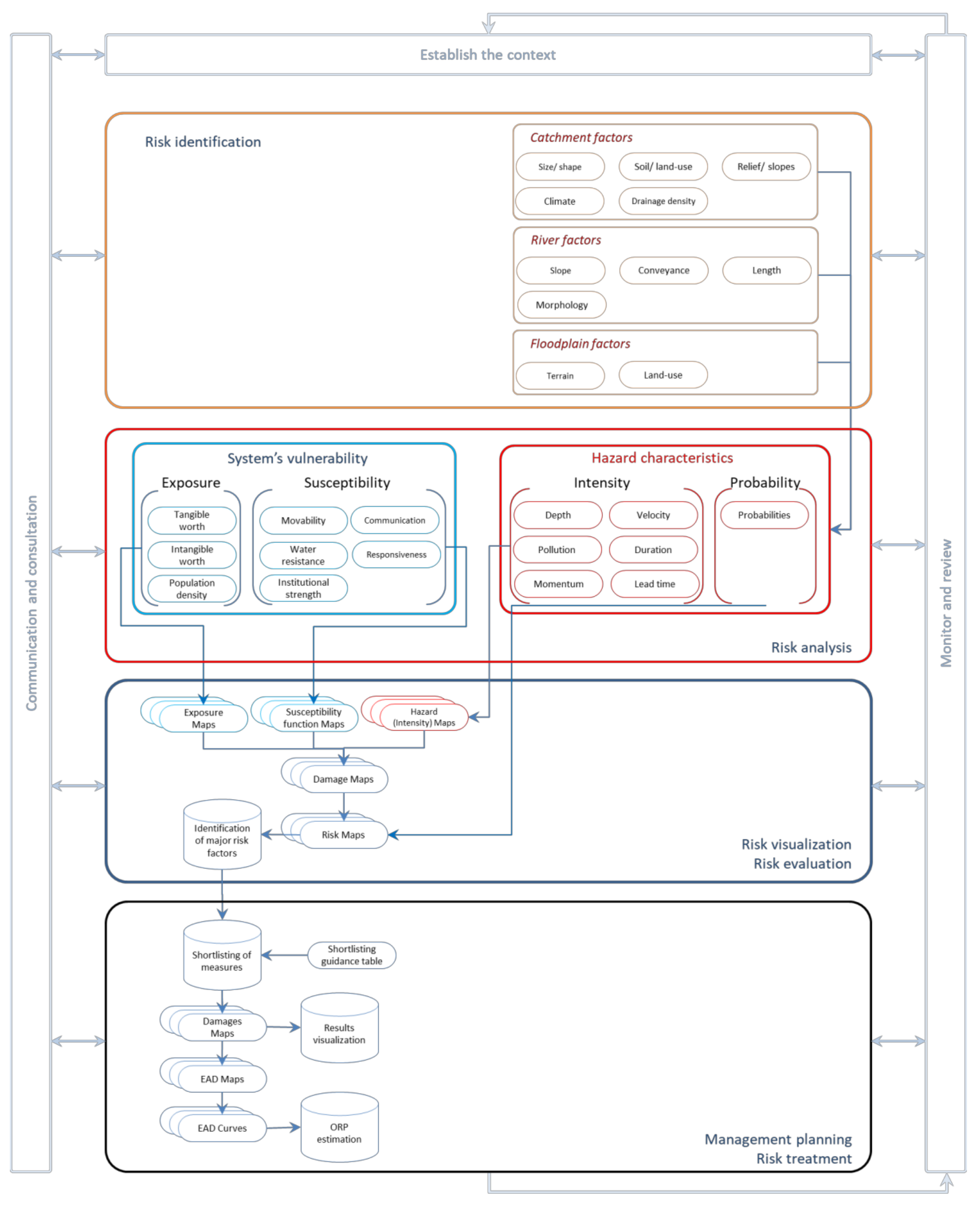
2.1. Risk-Based Flood Management

Management and coordination of measures/actions that are used to reduce flood problems can be considered to be flood management [32]. An effective flood strategy reduces risk by reducing hazards (by reducing the probability and/or intensity of flooding) or vulnerability (by reducing the susceptibility and/or exposure). The measures are selected and designed to achieve the desired results within the economic, social, and environmental limitations. Evaluation criteria need to be clear, transparent, and object-oriented and include social appraisal and economic and environmental evaluation due to nonstructural and structural technical requirements. The reliability of evaluation depends on the correct assessment of the inputs, such as flood frequency, the vulnerability of the exposed asset, and other risk factors [3].
“Flood management” refers to the overall process involved in mitigating the extent of flooding and the resulting damage by flooding [18], whereas “risk-based flood management” is the combination of all actions that aim to meliorate overall activities in a floodplain [33]. Risk-based management is geared towards evaluating the projects for reducing, but not necessarily eliminating, the flood risk [34]. In practical terms, the chance of flooding can never be eliminated. However, the consequences of flooding can be mitigated by appropriate behaviors and actions [2]. The basic principle of flood risk management should be “adjusting from both ends to achieve moderation” [35]. Vulnerability and/or hazard parameters can be adjusted to improve the floodplain functions. The flood management options available can be defined as those that reduce the challenge and those that enhance the individuals’ and society’s ability to cope with the flood. Typically, a mixture of methods would be the most effective management technique.
The most important task regarding flood management is to select the most effective and suitable measure from direct (flood abatement, flood control, and flood alleviation) and indirect measures (involving structural and nonstructural measures) [17,36]. A risk-based assessment enables policy-makers to focus on the outcomes and, thus, results in a set of the most suitable flood management measures. Risk-based flood management provides a rationale to spend resources on flood management options [3]. Resources can be spent in proportion to the risk involved, whereas the risk arises due to the combined environmental, social, and economic impacts of flooding. Hence, risk-based flood management facilitates the effective selection of different options. The research conducted by Pezzoli A., et al. [37] discussed the meteorological, hydraulic, and statistical fields of knowledge. In another similar attempt, a multivariate statistical model was set up to represent a typical probability distribution of measured river or sea level data at multiple locations by R. Lamb et al. [38] for the development of a risk-based assessment methodology for the UK. A proposed stepwise framework to evaluate the efficiencies of the flood management scheme is presented in Figure 1. The proposed framework is fitted into the recommended context of ISO Guide 31000 [39] to ensure the standardization of the approach.

2.2. Classifying Suitable Measures

A detailed risk assessment of all possible flood management measures is not economically feasible. Using available data, a competent professional with knowledge of the flood management domain can discard certain flood management options without analyzing each of them in depth [40]. Similarly, there are certain measures that are preferable under certain prevailing conditions [41]. For example, floodproofing of individual areas within the floodplain has proved economically more feasible than flood protection by constructing dikes under conditions where the floodplain is not densely populated [36]. A few measures are highly counterproductive in certain situations. One example is constructing a dike in mountainous areas, where flood levels fluctuate more rapidly and the chances of dike failure are high. In this case, the dike prevents the floodwaters from receding once the flood peak has passed. Which flood measures are selected depends on the available resources, technical limitations, and the effectiveness of an individual measure. The following are common examples of flood management measures, with a brief description:
  • Reservoirs reduce the flood peaks holding the surplus flows.
  • Rain harvesting also works in the same way as reservoirs but on a smaller scale. The stored water is used mainly for domestic purposes.
  • Dikes, levees, floodwalls, and other barriers suppress the flood hazard from reaching settlements, thus avoiding the risk.
  • Channel improvements facilitate the convenience of flow within a channel and reduce the stage against a high discharge by widening, deepening, smoothing, or removing curves from a channel.
  • A diversion (or bypass) of the flow capacity of a channel is increased by diverting a part of the flow to follow a different flow path and rejoining the main stream at a downstream point, where appropriate.
  • Insurance and relief are approaches to make the system more robust by increasing the recovery speed and extent of recovery. These options also play an indirect role in controlling exposure and susceptibility within a floodplain.
  • Flood warnings, rescue, and pre-emptive evacuation are capacity-building measures within the floodplain that enhances the capacity of settlements to react against floods by moving out or removing the assets from a floodplain in time.
  • Public awareness is a multidimensional tool that helps us to react against floods in many ways because of the flexibility and effectiveness of allowing settlements to understand flood issues, management options, and response options.
  • Flood zoning, encroachment control, and implementing building codes are effective tools to control the vulnerability of floodplains in an effective way.
The selection of a suitable measure is carried out by considering the appraisal requirements and the contribution of the measures in achieving the appraisal objectives. Different flood management options should be evaluated one by one by approximation. Developing options correctly can save time and resources. The following steps are recommended to develop the most suitable combination for appraisal needs.
  • Identification of a wide range of options by considering the topographical, environmental, social, cost-effective constraints.
  • Screening out of impractical and infeasible options.
  • Shortlisting of options that will most probably achieve the best use of resources.
  • Development of a wide range of options by combining different measures.
Table 1 provides a rule of thumb guideline example to shortlist the measures under the predominant conditions of the floodplain. The data are compiled based on an extensive literature review and field experts’ opinions. This guidance is tentative and based on a range of typical benefits, including reduced costs and additional socioenvironmental benefits.

3. Comparison of Mutually Exclusive Alternatives

The ultimate purpose of risk analysis is to enable decision-makers to select the best available option and envisage risk reduction after a proposed project is implemented [17,25]. There are several financial techniques to support the appraisal process (e.g., cost–benefit analysis, multicriteria analysis) [6].

3.1. Opportunity Cost

Resources at the national level are limited and have different uses. The use of resources for one purpose or project implies the foregone benefit from another purpose or project that could be achieved by using the same resources. Since the objective is to maximize returns, the alternative project that is relevant here is one with the maximum output or benefit. The opportunity cost of using resources in any project is, therefore, equal to the maximum value of output that could have been produced elsewhere with the same resources. For example, the opportunity cost of money invested by a farmer is the annual interest that the money would have received if the farmer had lent it to someone or deposited it in a bank. Similarly, the cost of producing a single unit of hydroelectricity is the cost of producing a single unit of thermal energy.
More importantly, this concept can be used to determine the value of unpriced assets. Thus, the opportunity cost of preserving the land for a national park can be estimated by deriving the income from other land uses that had to be abandoned or forfeited for the sake of conservation. This technique is also used to evaluate the benefits of preservation that are not valued on their own.

3.2. Feasibility Analysis

Damage can be divided into tangible and intangible damage. Intangibles are the losses that cannot be expressed in monetary terms with conventional approaches. Multicriteria analysis (MCA) is a common tool to assess intangible losses [42]. However, for a risk-based design, all possible damage due to floods are converted into tangible losses and evaluated through a cost–benefit analysis (CBA) to achieve maximum efficiency of the flood management approach.

3.2.1. Cost–Benefit Analysis

Most of the projects need to be financially attractive to be sanctioned for financing. CBA is performed to determine the adequacy of a project to assess its ability to meet the objectives. The analysis is helpful for designing the best combinations of flood measures [43,44,45]. While comparing the costs and benefits of a project, the costs for flood management has two components: the capital costs of measures and their maintenance cost. The costs also include the reduction in productivity within the floodplain, which might have been there in the absence of flooding or flood management measures as these costs are invested in before the flood occurs. Therefore, discount rates must be considered by assuming the service life cycle of the measure (see Section 3.4).
Benefits can be defined as the damage that is avoided due to flood management measures. This way, the benefits include a reduction in losses due to a flood management project [43]. Risk-based flood management demands that all costs and all benefits must be accounted for. The costs and benefits must be converted into monetary terms to perform a CBA.

3.2.2. Valuation of Intangible Assets

As mentioned above, the costs, as well as the benefits, consist of tangibles and intangible components. CBA becomes difficult if these intangible costs and benefits are not converted into tangibles [46]. Some advanced and systematic approaches are required to handle the intangibles. Alternatively, CBA can be expanded using a nested multicriteria framework to consider intangible factors along with tangible factors [47]. MCA covers multiple aspects of gains and losses and handles these separately. Sometimes, weights are assigned to different criteria to determine the results of the MCA, but these are always highly controversial and questionable. MCA provides an elaborated and detailed picture of the problem [47] but, at the same time, lacks the ability to facilitate policy-makers choosing between the options as an apple-to-apple comparison is not carried out with this approach. CBA is, therefore, recommended to allow decision-makers to make a “like for like” comparison. Zeleńáková and Zvijáková [41] introduced a qualitative approach to cover multiple parameters in a risk assessment.
When costs and benefits are compared against different projects, a comparative risk assessment (CRA) is obtained. CRA is used to identify the most effective flood management scheme in the context of appropriate flood management options. As a governing principle, the lowest risk is the most desirable [44]. Therefore, utmost efforts should be made to ensure that the maximum possible number of alternative projects or policies are analyzed under CRA [29]. CRA is used to obtain the “optimal risk point” (ORP; discussed under Section 4.2) for the design of “master flood action plans” and the most appropriate land use planning in the floodplains (see Figure 2). It is important to note that CRA for an individual project is not possible. Consequently, isolated evaluation of projects without considering the optimum risk status of the overall strategy could be misleading.

3.3. Economic Efficiency Indicators

The outcomes of a CBA are communicated using economic efficiency indicators; these economics efficiency indicators are broadly divided into two classes. The first group of indicators expresses the ratio between inputs and outputs, while the other class of indicators considers the difference in costs and benefits. A few of the most common indicators are described in the following sections.

3.3.1. Benefit–Cost Ratio (BC Ratio)

The benefit–cost ratio can be considered as the most common indicator that compares the investments and the benefits. The decision-making process can have high confidence in this indicator due to its ability to provide the gain in terms of investment percentage [48]. An example of the popularity of this indicator is that the flood defense programs in the United Kingdom must have a BC ratio of more than 8 to receive public funding [25].

3.3.2. Internal Rate of Return (IRR)

Another important term used to evaluate the feasibility of a project is the “internal rate of return” (IRR). IRR evaluates the project through its life of cash flows. If net present value (NPV) is equal to zero, IRR is equal to the discount rate. IRR is the discount rate at which the cost of the project leads to the benefit of the project [8,49]. The World Bank uses IRR as a qualifying indicator for financing projects [50].

3.3.3. Economic Rent (ER)

An increase in land-use efficiency due to reduced flooding is a benefit of flood management. Economic rent (ER) considers the efficiency of land uses in a floodplain. ER is defined as the net annual revenue associated with a resource that can be land use for a floodplain [51,52]. ER is an indicator that combines the effectiveness of alternatives to achieve the economic objectives of floodplain management.
The average annual net return, discounted to its present value, can be considered the ER of land use in a floodplain. If “Rn” is the annual net return of a unit of land area in year “n”, assuming a constant discount rate “r”, then the “ER” in time “t” will be the average discounted annual net return. This relationship can be expressed using the following formula:
E R = n = 0 n = t R n t 1 + r n
It is also possible to define the net annual return per unit of land as the difference of annual gross returns to total costs (excluding land rent), which represents economic efficiency [51]. In the case of a floodplain, the annual cost of the measure, including capital and maintenance costs, and the expected residual damage reduce the ER; these are called combined deductions. Therefore, ORP can also be defined as a state of flood management when the risk of ER reduction is minimal.
“Location benefits” (Rloc) and “intensifying benefits” (Rint) are the two parts of ER (please refer to Equation (2)). Rloc is connected with the availability of land for intensive economic uses, e.g., shifting from agriculture to industrial land use [53], whereas, Rint is the value of increasing land use such as changing from lower- to higher-value crop cultivation or, alternatively, producing higher-yield crops or intensifying agricultural economic activities [53].
Δ R n = Δ R l o c + Δ R i n t
The negative impacts of floods are reduced with improved flood management, which results in an increase in both components by higher flows of investments. Although several factors depend on an increase in location benefits and intensification benefits, the availability of investments is the most important factor by itself. Investment project planning in the floodplain is subject to a precise evaluation of ER.

3.4. Discounting Procedure

Although floods cause damage to life and infrastructure, in order to reduce this damage, flood measures also require substantial investment. Investments in flood measures are ideally low and paid in advance, while the cost of flood damage is high and, with some probability, may occur in the future [54]. By reducing losses every year, flood measures provide advantages throughout their service life. Flood measures need capital investment at the start and some maintenance costs annually. Such capital investments, if deposited in a bank, could produce some annual return (equal to the compound interest or discount rate “i”). Therefore, it is not possible to consider future returns from flood measures equal to those obtained at the present time. These two sets of unevenly distributed advantages and costs are handled by the concept of present value (PV).
PV is a basic concept of economics that accounts for the time value of money as opposed to the future value concept. The Kaldor–Hicks compensation principle is a criterion that helps in this analysis by measuring the NPV over the expected life of the project [55]. In all analyses that compare investments and results, the discount rate is considered. Typically, the discount rate used is set by the federal government and is much higher in developing nations than in developed nations. It is possible to find the present value “PV” of investment “P” with “i” interest rate over time “t” (in years) using Equation (3).
P V =   P 1 + i t
The costs and benefits are spread over different timestamps. Therefore, the rent on investments cannot be ignored. It is logical to compare the difference in investments and benefits in terms of present values. The BC ratio and net benefits (NBs) of a project can be calculated using the following formulae (refer to the formulas in Equations (4) and (5)) after the PV of benefits and costs have been estimated [29]:
B C   r a t i o =   P V b P V c
N B =   P V b P V c
If the net benefits are positive, then the project is cost-efficient, and the BC ratio is greater than 1. Kaldor and Hicks had a simple criterion, NPV > 0, for determining whether a project is economically feasible over time [55]. The necessary condition for the adoption of a project is that discounted benefits “PVb” should exceed discounted costs “PVc” (see Equation (6)) or NPV should be greater than zero [8,56] (see Equation (7)).
P V b > P V c
N P V >   0
As mentioned above, a project is economically feasible if the benefits are more than the costs, but the priority of projects is required in case of limited resource availability. This prioritization of projects may help in phase-wise execution of the projects or may help in selecting which projects to reject based on a cutline criterion. Nevertheless, the priority ranking of projects is always based on BC ratios. Additionally, the projects exhibiting the highest net benefits could be the preferred projects when reasonable resources become available or the availability of resources is not restrained [43].

4. Decision Support System

The aim of flood management can be to maximize net benefits within floodplains, rather than aiming solely at minimizing flood damage.

4.1. Expected Annual Damage (EAD)

Risk-based assessment methods assist decision-makers in envisaging the spatial and temporal risk distributions of floodplains. A probabilistic event [57] is flood damage, and flood intensity varies greatly over the floodplain. To date, the spatial distribution of risks and the benefits of flood mitigation measures have seldom been taken into account [58]. The average level of damage that could be expected annually due to the probabilistic nature of floods and flood losses is the expected annual damage (EAD). De Risi et al. [59] used an approach to evaluate the feasibility of life cycle cost (LCC) and return on investment (ROI) analysis strategies and found that by reducing expected annual damage, the projects produced net welfare gains. Damage curves and maps of EAD distribution provide an extensive illustration of the distribution of risk. Pellicani, R. et al. [60] used risk curves on a basin and subbasin basis to represent the temporal variability of flood risk for decision making. To discover the lateral trends in risk along the river, EAD can also be calculated across the flow. Therefore, decisions based on EAD have benefits over conventional approaches. EAD provides the risk estimate and shows how far from achieving the optimal risk point (“ORP”) the current flood management practice is.
In the 1990s, to develop a hydroeconomic model for EAD estimation [57], the US Army Corps of Engineers used the relationships between damage, frequency, discharge, and stage. If flow conditions and societal vulnerability remain unchanged, these correlations function well. Structural measures substantially alter the flow regime and flood behavior. Once the flow regime is changed, relationships previously developed are no longer applicable. Therefore, a hydroeconomic model cannot be used under such conditions. In order to handle such changes appropriately, detailed analysis using GIS data and a 2D hydrodynamic model is required. Based on the actual conditions of the floodplain, the method supports EAD calculation. In addition to their potential benefits and proposed uses, the concepts of EAD, damage curve, and EAD distribution map have been introduced (see Equations (8) and (9)).
E A D = i = 0 i = D i × Δ P i
D i = D P i 1 + D P i 2
It is important to note that the term “expected” is used instead of “average”. The reason is that the damages or losses are probabilistic in nature and are calculated using the exceedance of probability fittings to estimate the hazard and the resulting damage [61].

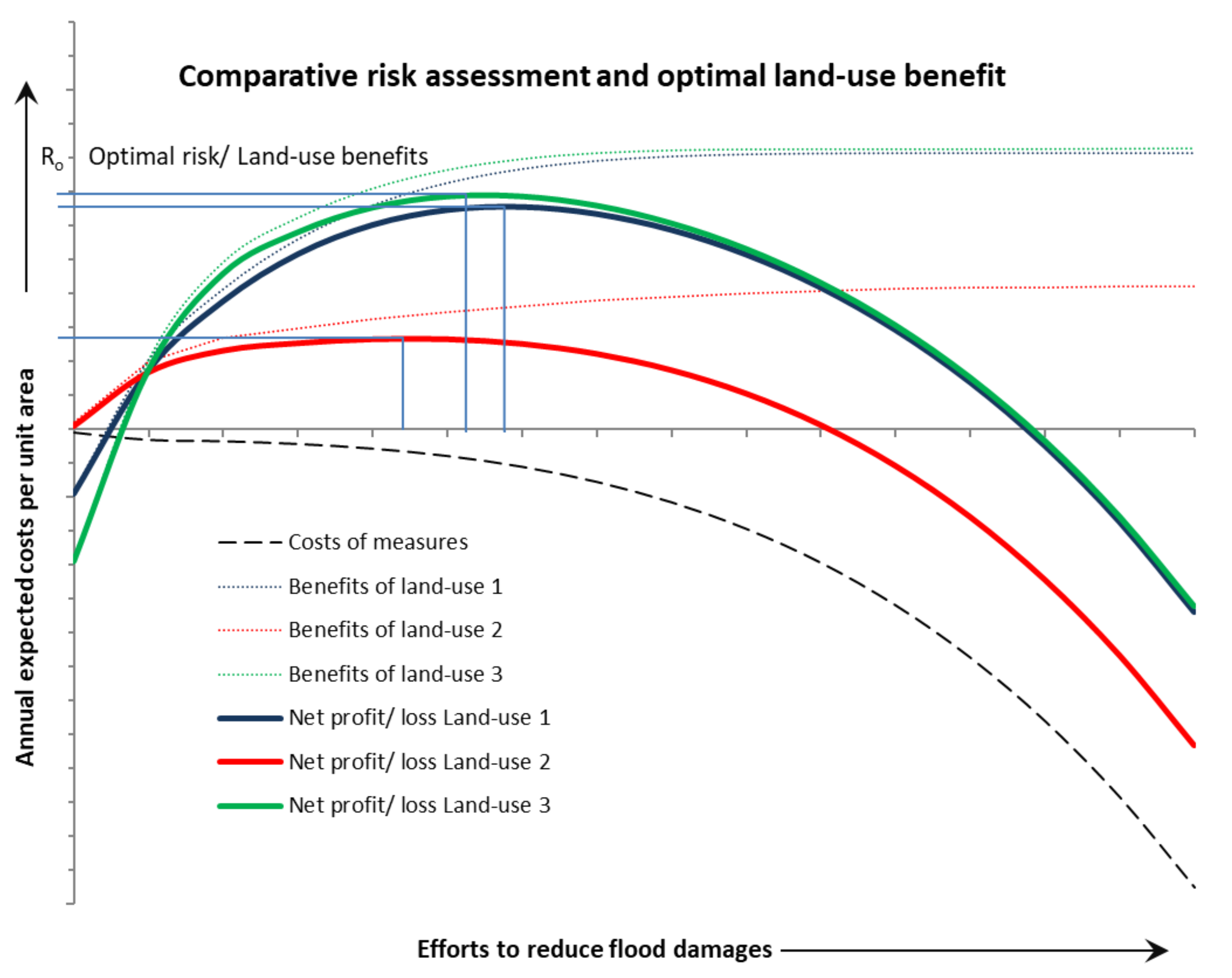
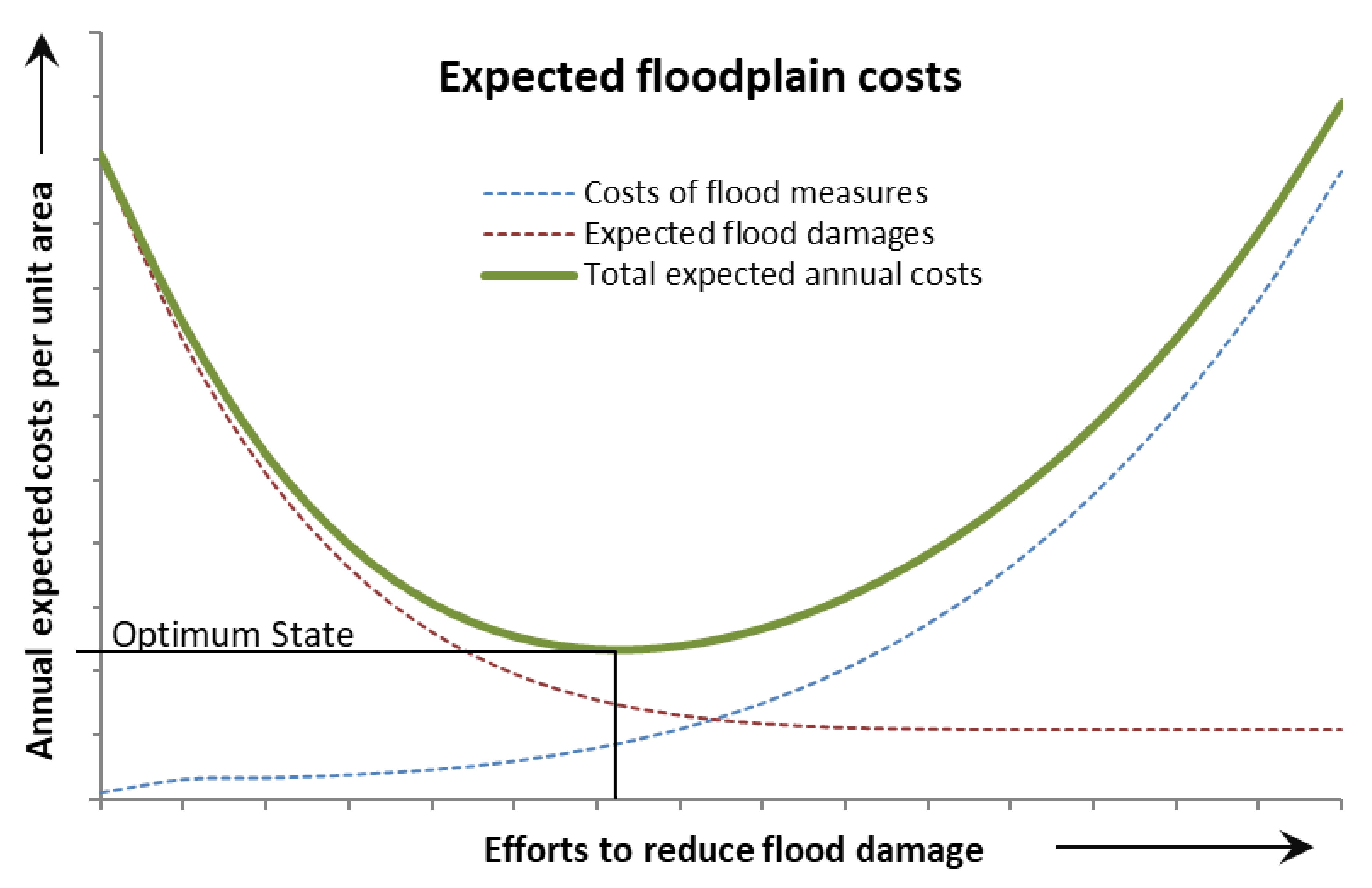
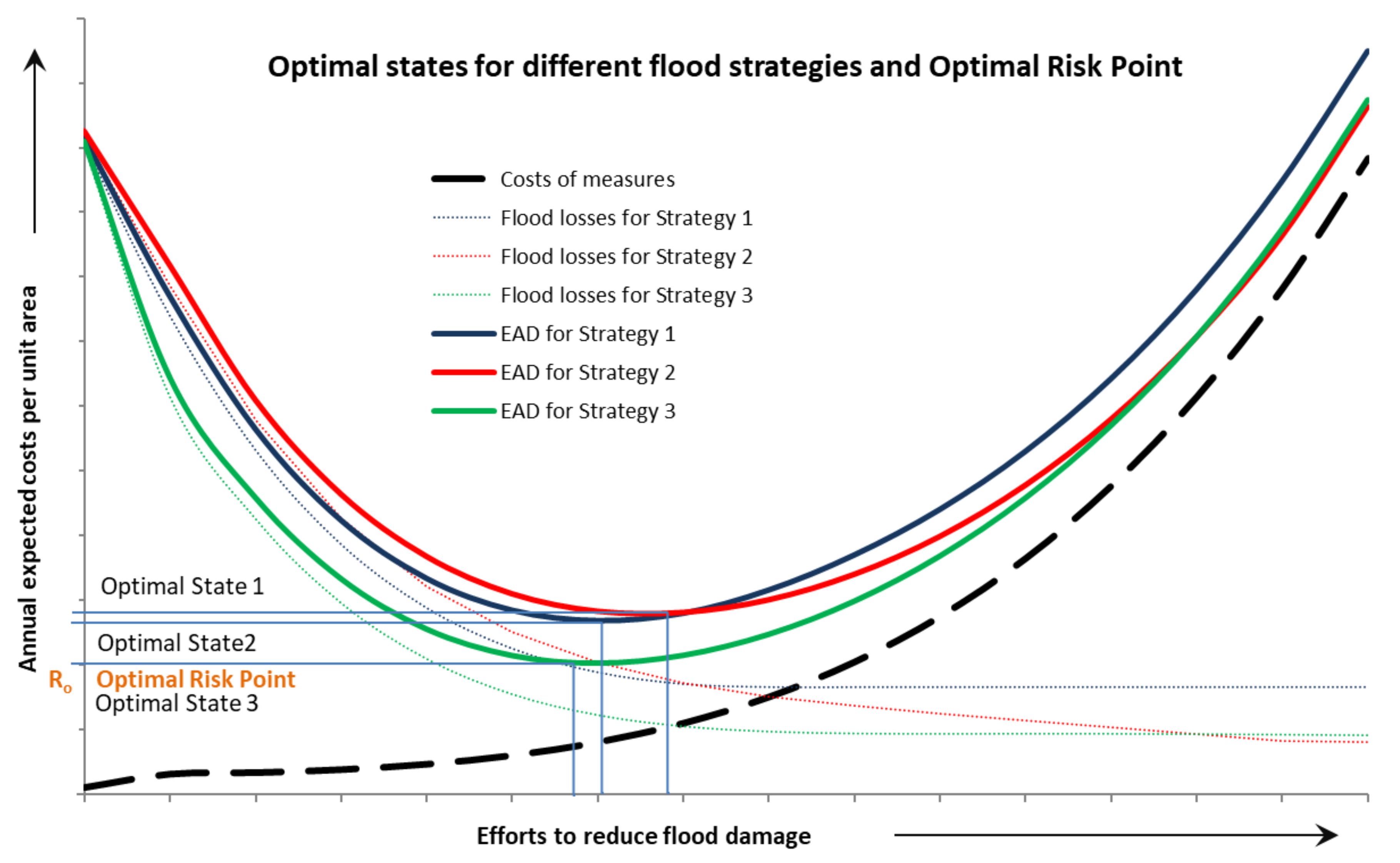
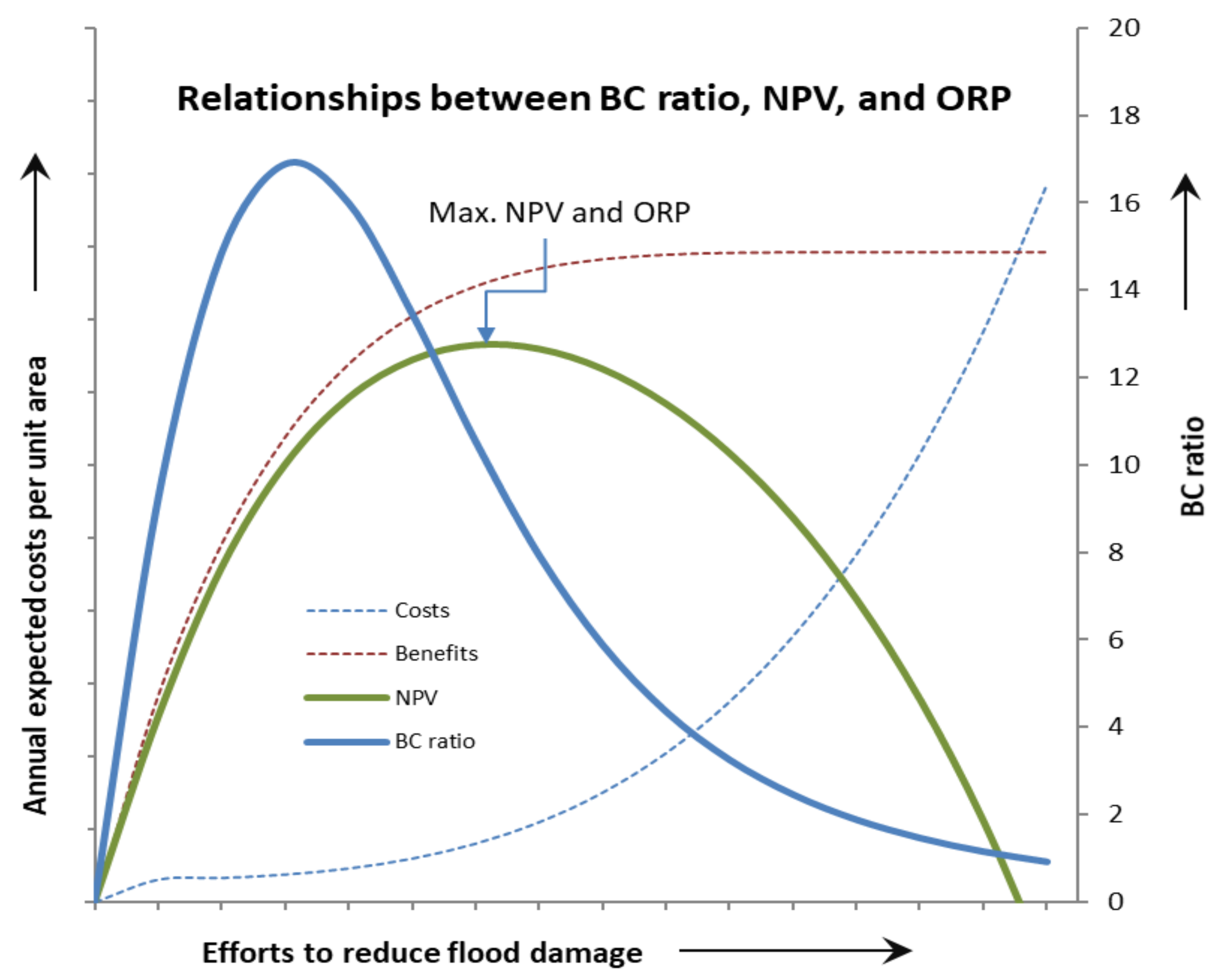
4.2. Optimum State and Optimal Risk Point

Flood management must have the ultimate purpose of reducing risk. In such situations, risk cannot be entirely nullified. Flood measures reduce flood losses, but, at the same time, these measures incur high capital and maintenance costs for operational maintenance. This means that the risk cannot be reduced beyond a certain threshold in a floodplain. At this threshold, the combined annual expected losses due to flood damage and the cost of measures are reduced to a minimum.
Measures taken in a floodplain generally have high BC ratios in the initial stages. For measures taken after that, the BC ratio decreases and may reach 1 or even lower for subsequent measures. The stage in which marginal measurement costs and marginal benefits are equal reflects the “optimum state” (see Figure 3) [62,63].
Various flood management schemes may show different optimum states. Under all favorable combinations of flood measures, the optimum state with the lowest risk (expected costs) is known as the “optimal risk point” (ORP). As to how different strategies (consisting of appropriate measures) are compared, the ORP concept is explained in Figure 4. It also compares the feasibility of the land-use practices proposed and supports the idea that only when ORP is achieved in a floodplain can maximum land-use benefits be obtained.

4.3. Options under Constrained Resources

The benefit of a probability-based approach is that it is possible to establish uniform standards nationwide. So far, risk-based approaches have failed to provide standards that could be practiced across a nation uniformly. In terms of risk-based standards, the ORP concept allows flood management to be described. The present or proposed flood management status can be described in a floodplain as a ratio or percentage of ORP. The “flood management ratio” (FM ratio) reflects the ratio of present EAD and EAD at ORP. Theoretically, the FM ratio for any flood management is justified at 1 or 100% except where a shortage of resources are the main constraint and stepwise phases are planned to achieve ORP.
The use of common economic efficiency factors, as described in the above sections, may not bring up the most efficient flood management plans. As mentioned in Section 3.3, economic indicators can be classified into two distinct groups. Some indicators compare the ratios of input–output and others compare the differences in input–output. The input–output ratio is represented most effectively by the BC ratio. The difference in cost–benefit, ER, IRR, NPV, and EAD are based on the difference in input–output (or sometimes, the rate of difference). These indicators (apart from EAD) are intended to assess the benefits of an investment. These can also be used for performance assessment of investments made on flood measures. Nevertheless, the use of these indicators for flood management planning is not recommended. These indicators could be misleading and may derail the planning techniques from achieving ORP. The maximum possible ER of an available resource in a floodplain can only be attained at ORP (see Figure 5). The most efficient line of action should be determined or established upon using the proposed ORP standards. However, priorities can be assigned to individual measures within the master plan for situations where there are budget constraints, with the help of common indicators (normally the BC ratio) that are appropriate to the situation and the constraints.
Flood-related damage and measure-related costs and benefits can be represented using EAD (see Section 4.1). The calculation of EAD involves multiple cycles of analysis, including hydrodynamic and economic modeling. Different scenarios of flood management options on proposed land use may come up with different EADs, giving multiple optimal points against different measures or combinations of measures. Multiple iterations of analyses are required to be carried out in a floodplain under several scenarios to optimize flood management. The economic efficiencies of proposed measures can be reassessed at the planning stage to allocate priorities to individual projects in the context of situational constraints and preferences. The outcomes of risk analysis can be expressed using the BC ratio, NPV, ER, IRR, and EAD to facilitate policy-makers who are finalizing flood management arrangements.

5. Conclusions and Recommendations

Flood management practices have evolved. Risk-based flood management is now generally recognized around the world. Nevertheless, design procedures and criteria follow the probability-based design of flood management schemes. An estimate of risk reduction of a proposed flood management project can be made using risk analysis to help decision-makers select the most viable option. The Kaldor–Hicks compensation principle acts as the ruling principle for floodplain management systems. It establishes the governing rule that benefits should exceed the cost before policies and projects are sanctioned. The research also recommends that objective flood management should be the “welfare of society” by assigning the same weightage to all individuals.
For risk-based flood management, CBA is recommended to determine the efficiency of a project and define the best composition of a project. Costs can be estimated for the service life using discounting procedures, and the benefits can be equated to the damage avoided. The benefits of a project are, therefore, equal to the difference in damage due to the project. Intangible losses must be included in the analysis. In the analysis, social and environmental assets are as important as economic assets in order to obtain reliable outcomes. However, the conversion of an intangible component into scalar monetary value remains controversial. The exclusion of intangibles is, however, a worse option. Developing intangible-to-tangible value criteria at the national level can reduce disagreements. Such criteria could be used for all types of projects at the national level as well.
CRA is an effective option to single out the most effective flood management option by analyzing the risks of alternative projects or policies while considering that the lowest risk is the most appropriate solution. CRA is a useful tool to determine ORP for any master plan consisting of flood management measures and land use in a floodplain.
Normally, the results of a CBA can be represented using economic efficiency indicators, and these indicators are used to find the most adequate measure. The BC ratio is used to express, with confidence, the proportion of what has been spent and achieved during the decision appraisal, while IRR is used to determine the return of the project throughout its service life. IRR, NPV, and BC ratio are common indicators to express the feasibility or priority of projects within a master plan. However, for flood management, EAD is strongly recommended to envisage the performance of land-use practices and flood measures simultaneously.
It can be concluded that the efficiency of floodplain land use is at its maximum at ORP under the prevailing flood management techniques and their costs. Therefore, determining the ORP could be the start point for flood management planning. Once the ORP is determined, the short-term planning measures should consist of only those projects that match the long-term strategy of achieving ORP. Nevertheless, common established indicators can be used to assign the priorities to shortlisted projects using the BC ratio (recommended). However, extensive modeling efforts and analyses are required to determine the ORP. It is difficult to achieve the ORP immediately with limited resources. In that case, the flood FM ratio can be used to describe the extent of flood management in a standardized way for stepwise planning to obtain the ORP on a national level. The FM ratio guides us in identifying the present divergence from achieving the ORP within a floodplain.
It is also important to mention here that, once established, the ORP must be re-evaluated periodically. The research presented here is among the initial attempts to develop a formal risk-based flood management standard that can be established on a nationwide basis. Several potential modifications and improvements to the presented methodology are possible. Further research, case studies, and discussions are required before the proposed approach is established and recognized as a standard approach at a national level. The authors expect that further development of the approach may replace probability-based standards.

Author Contributions

Conceptualization, M.A.U.R.T. and N.v.d.G.; Data curation, M.A.U.R.T.; Formal analysis, M.A.U.R.T. and R.F.; Investigation, M.A.U.R.T. and R.F.; Methodology, M.A.U.R.T. and R.F.; Software, M.A.U.R.T. and R.F.; Supervision, M.A.U.R.T. and N.v.d.G.; Validation, M.A.U.R.T.; Visualization, M.A.U.R.T. and R.F.; Writing—Original draft, M.A.U.R.T. and R.F.; Writing—Review & editing, M.A.U.R.T. All authors have read and agreed to the published version of the manuscript.

Funding

This research received no external funding.

Conflicts of Interest

The authors declare no conflict of interest.

References

  1. Aronica, G.T.; Candela, A.; Fabio, P.; Santoro, M. Estimation of flood inundation probabilities using global hazard indexes based on hydrodynamic variables. Phys. Chem. Earth Parts A B C 2012, 119–129. Available online: http://0-www-sciencedirect-com.brum.beds.ac.uk/science/article/pii/S1474706511000568 (accessed on 15 October 2020). [CrossRef]
  2. Borrows, P.; De Bruin, D. The management of riverine flood risk. Irrig. Drain. 2006, 55, S151–S157. [Google Scholar] [CrossRef]
  3. Apollonio, C.; Bruno, M.F.; Iemmolo, G.; Molfetta, M.G.; Pellicani, R. Flood Risk Evaluation in Ungauged Coastal Areas: The Case Study of Ippocampo (Southern Italy). Water 2020, 12, 1466. [Google Scholar] [CrossRef]
  4. APFM. Risk Sharing in Flood Management: A Tool for Integrated Flood Management; Associated Programme on Flood Management: Geneva, Switzerland, 2009. [Google Scholar]
  5. Blöschl, G.; Ardoin-Bardin, S.; Bonell, M.; Dorninger, M.; Goodrich, D.; Gutknecht, D.; Matamoros, D.; Merz, B.; Shand, P.; Szolgay, J. At what scales do climate variability and land cover change impact on flooding and low flows? Hydrol. Process. 2007, 21, 1241–1247. [Google Scholar] [CrossRef]
  6. Green, C.H.; Parker, D.J.; Tunstall, S.M.; Berga, L. Assessment of Flood Control and Management Options; World Commission on Dams: Cape Town, South Africa, 2000. [Google Scholar]
  7. FEMA. Flood Insurance Manual; FEMA: Washington, DC, USA, 2008. [Google Scholar]
  8. Tudose, N.C.; Ungurean, C.; Davidescu, Ș.; Clinciu, I.; Marin, M.; Nita, M.D.; Adorjani, A.; Davidescu, A. Torrential flood risk assessment and environmentally friendly solutions for small catchments located in the Romania Natura 2000 sites Ciucas, Postavaru and Piatra Mare. Sci. Total Environ. 2020, 698, 134271. [Google Scholar] [CrossRef] [PubMed]
  9. Qiang, Y. Flood exposure of critical infrastructures in the United States. Int. J. Disaster Risk Reduct. 2019, 39, 101240. [Google Scholar] [CrossRef]
  10. Agency, E. Understanding Flood Risk Using Our Flood Map; Identifying and Understanding Flood Risk in England & Wales; Environment Agency: Bristol, UK, 2006. Available online: www.environment-agency.gov.uk/floodmap (accessed on 11 October 2020).
  11. Prime, T.; Brown, J.M.; Plater, A.J. Flood inundation uncertainty: The case of a 0.5% annual probability flood event. Environ. Sci. Policy 2016, 59, 1–9. [Google Scholar] [CrossRef] [Green Version]
  12. Merz, B.; Thieken, A.H.; Gocht, M. Flood risk mapping at the local scale: Concepts and challenges. In Flood Risk Management in Europe; Begum, S., Ed.; Springer: Berlin/Heidelberg, Germany, 2007; pp. 231–251. [Google Scholar]
  13. Jonkman, S.N.; Voortman, H.G.; Klerk, W.J.; Van Vuren, S. Developments in the management of flood defences and hydraulic infrastructure in the Netherlands. Struct. Infrastruct. Eng. 2018, 14, 895–910. [Google Scholar] [CrossRef] [Green Version]
  14. Nordbeck, R.; Steurer, R.; Löschner, L. The future orientation of Austria’s flood policies: From flood control to anticipatory flood risk management. J. Environ. Plan. Manag. 2019, 62, 1864–1885. [Google Scholar] [CrossRef]
  15. Linde, A.H.T.; Bubeck, P.; Dekkers, J.E.C.; De Moel, H.; Aerts, J.C.J.H. Future flood risk estimates along the river Rhine. Nat. Hazards Earth Syst. Sci. 2011, 11, 459–473. [Google Scholar] [CrossRef] [Green Version]
  16. De Moel, H.; Van Alphen, J.; Aerts, J.C.J.H. Flood maps in Europe—Methods, availability and use. Nat. Hazards Earth Syst. Sci. 2009, 9, 289–301. [Google Scholar] [CrossRef] [Green Version]
  17. Tariq, M.A.U.R.; Hoes, O.; Ashraf, M.T. Risk-Based Design of Dike Elevation Employing Alternative Enumeration. J. Water Resour. Plan. Manag. 2014, 140, 05014002. [Google Scholar] [CrossRef]
  18. Van Duivendijk, J. Assessment of Flood Control and Management Options; World Commission on Dams: Cape Town, South Africa, 1999. [Google Scholar]
  19. Halcrow; Euroconsult; NDC. Capacity Building for Integrated River Management and Subprojects Implementation Design Criteria and Methodology: Package B; Federal Flood Commission: Islamabad, Pakistan, 2001. [Google Scholar]
  20. Halcrow. River Dove Strategy Scoping Report; Environment Agency: Bristol, UK, 2004. [Google Scholar]
  21. Andjelkovic, I. Guidelines on Non-Structural Measures in Urban Flood Management; UNESCO, International Hydrological Programme: Paris, France, 2001. [Google Scholar]
  22. ASFPM. Reducing Flood Losses: Is the 1% Chance (100-Year) Flood Standard Sufficient? Report of the 2004 Assembly of the Gilbert F. White National Flood Policy Forum; National Academies Keck Center: Washington, DC, USA, 2004. [Google Scholar]
  23. Nathwani, J.S.; Lind, N.C.; Pandey, M.D. Affordable Safety by Choice: The Life Quality Method; Institute for Risk Research: Waterloo, ON, Canada, 1997. [Google Scholar]
  24. Rusman, B.; Istijono, B.; Ophyandri, T.; Junaidi, A. Social, Economic and Environmental Perspectives of Flood Assessment on Delta Lowland. Int. J. Civ. Eng. Technol. 2017, 8, 966–978. [Google Scholar]
  25. Hino, M.; Hall, J.W. Real Options Analysis of Adaptation to Changing Flood Risk: Structural and Nonstructural Measures. ASCE ASME J. Risk Uncertain. Eng. Syst. Part A Civ. Eng. 2017, 3, 04017005. [Google Scholar] [CrossRef]
  26. Song, Y.; Kirkwood, N.; Maksimović, Č.; Zheng, X.; O’Connor, D.; Jin, Y.; Hou, D. Nature based solutions for contaminated land remediation and brownfield redevelopment in cities: A review. Sci. Total Environ. 2019, 663, 568–579. [Google Scholar] [CrossRef] [PubMed]
  27. Hoes, O.; Schuurmans, W. Flood standards or risk analyses for polder management in the Netherlands. Irrig. Drain. 2006, 55, S113–S119. [Google Scholar] [CrossRef]
  28. Door, K.; de Bruijn, M.; van Beek, E. Resilience and Flood Risk Management: A Systems Approach Applied to Lowland Rivers; Technische Universiteit Delft: Delft, The Netherlands, 2005. [Google Scholar]
  29. Pearce, D.; Atkinson, G.; Mourato, S. Cost-Benefit Analysis and the Environment: Recent Developments; Organisation for Economic Co-Operation and Development: Paris, France, 2006. [Google Scholar]
  30. Martin, S. The Potential Compensation Principle and Constant Marginal Utility of Income. Jpn. Econ. Rev. 2019, 70, 383–393. [Google Scholar] [CrossRef]
  31. Erdlenbruch, K.; Thoyer, S.; Grelot, F.; Kast, R.; Enjolras, G. Risk-sharing policies in the context of the French Flood Prevention Action Programmes. J. Environ. Manag. 2009, 91, 363–369. [Google Scholar] [CrossRef] [Green Version]
  32. Riquet, M.D.; Paudyal, D.G.; Dolcemascolo, M.G.; Abo, M.F.J. Integrated Flood Risk Management in Asia 2; The Asian Disaster Reduction Center (ADRC): Bangkok, Thailand, 2005. [Google Scholar]
  33. Tariq, M.A.U.R.; van de Giesen, N.; Hoes, O. Development of expected annual damage curves and maps as a basic tool for the risk-based designing of structural and non-structural measures. In Floods in 3D: Processes, PatternsPredictions, Proceedings of the EGU Leonardo Conference, Bratislava, Slovakia, 23–25 November; Szolgay, J., Danáčová, M., Hlavčová, K., Kohnová, S., Pišteková, V., Eds.; Slovak University of Technology in Bratislava: Bratislava, Slovakia, 2011. [Google Scholar]
  34. Pilon, P.J.; Davis, D.A.; Halliday, R.A.; Paulson, R. Guidelines for Reducing Flood Losses; Inter-Agency Secretariat of the International Strategy for Disaster Reduction (UN/ISDR): Geneva, Switzerland, 2003. [Google Scholar]
  35. Cheng, X. Recent progress in flood management in China. Irrig. Drain. 2006, 55, S75–S82. [Google Scholar] [CrossRef]
  36. Abbas, A.; Amjath-Babu, T.S.; Kächele, H.; Usman, M.; Iqbal, M.A.; Arshad, M.; Shahid, M.A.; Müller, K. Sustainable survival under climatic extremes: Linking flood risk mitigation and coping with flood damages in rural Pakistan. Environ. Sci. Pollut. Res. 2018, 25, 32491–32505. [Google Scholar] [CrossRef]
  37. Pezzoli, A.; Cartacho, D.L.; Arasaki, E.; Alfredini, P.; Sakai, R.D.O. Extreme Events Assessment Methodology Coupling Rainfall and Tidal Levels in the Coastal Flood Plain of the Sao Paulo North Coast (Brazil) for Engineering Projects Purposes. J. Clim. Weather Forecast. 2013, 1. [Google Scholar] [CrossRef] [Green Version]
  38. Lamb, R.; Keef, C.; Tawn, J.; Laeger, S.; Meadowcroft, I.; Surendran, S.; Dunning, P.; Batstone, C. A new method to assess the risk of local and widespread flooding on rivers and coasts. J. Flood Risk Manag. 2010, 3, 323–336. [Google Scholar] [CrossRef]
  39. Purdy, G. ISO 31000:2009-Setting a New Standard for Risk Management. Risk Anal. 2010, 30, 881–886. [Google Scholar] [CrossRef] [PubMed]
  40. Ahmad, S.; Simonovic, S.P. Integration of heuristic knowledge with analytical tools for the selection of flood damage reduction measures. Can. J. Civ. Eng. 2001, 28, 208–221. [Google Scholar] [CrossRef]
  41. Zeleňáková, M.; Zvijáková, L. Environmental impact assessment of structural flood mitigation measures: A case study in Šiba, Slovakia. Environ. Earth Sci. 2016, 75. [Google Scholar] [CrossRef]
  42. Dassanayake, D.R.; Burzel, A.; Oumeraci, H. Coastal Flood Risk: The Importance of Intangible Losses and Their Integration. Coast. Eng. Proc. 2012, 1. [Google Scholar] [CrossRef] [Green Version]
  43. Medina, D. Benefit-Cost Analysis of Flood Protection Measures; Metropolitan Water Reclamation District of Greater Chicago: Chicago, IL, USA, 2006. [Google Scholar]
  44. Azmeri, A.; Yunita, H.; Safrida, S.; Satria, I.; Jemi, F.Z. Physical vulnerability to flood inundation: As the mitigation strategies design. J. Water Land Dev. 2020, 46, 20–28. [Google Scholar] [CrossRef]
  45. Pesaro, G.; Mendoza, M.; Minucci, G.; Menoni, S. Cost-benefit analysis for non-structural flood risk mitigation measures: Insights and lessons learnt from a real case study. In Safety and Reliability—Safe Societies in a Changing World; Haugen, S., Barros, A., van Gulijk, C., Kongsvik, T., Vinnem, J.E., Eds.; CRC Press: Boca Raton, FL, USA, 2018; Chapter 14; pp. 109–118. [Google Scholar] [CrossRef]
  46. Kron, W. Flood Risk = Hazard X Exposure X Vulnerability. In Proceedings of the 2nd International Symposium on Flood Defence, Beijing, China, 10–13 September 2002; pp. 82–97. [Google Scholar]
  47. Tung, Y.-K. Risk-based design of flood defense systems. In Proceedings of the 2nd International Symposium on Flood Defence, Beijing, China, 10–13 September 2002. [Google Scholar]
  48. Messner, F.; Penning-Rowsell, E.; Green, C.; Meyer, V.; Tunstall, S.; van der Veen, A. Evaluating Flood Damages: Guidance and Recommendations on Principles and Methods; FLOODsite Consortium: Wallingford, UK, 2007. [Google Scholar]
  49. Yi, C.-S.; Lee, J.-H.; Shim, M.-P. GIS-based distributed technique for assessing economic loss from flood damage: Pre-feasibility study for the Anyang Stream Basin in Korea. Nat. Hazards 2010, 55, 251–272. [Google Scholar] [CrossRef]
  50. Tan, J.-P.; Anderson, J.R.; Belli, P.; Barnum, H.N.; Dixon, J.A. Economic Analysis of Investment Operations; THE WORLD BANK: Washington, DC, USA, 2001; Volume 8. [Google Scholar] [CrossRef]
  51. Weisz, R.N.; Day, J.C. A regional planning approach to the floodplain management problem. Ann. Reg. Sci. 1975, 9, 80–92. [Google Scholar] [CrossRef] [Green Version]
  52. Wandji, Y.D.F.; Bhattacharyya, S.C. Evaluation of economic rent from hydroelectric power developments: Evidence from Cameroon. J. Energy Dev. 2017, 42, 239–270. [Google Scholar]
  53. USACE. Engineering and Design: Risk-Based Analysis for Flood Damage Reduction Studies; U.S. Army Corps of Engineers: Washington, DC, USA, 1996. [Google Scholar]
  54. Bakkensen, L.A.; Ma, L. Sorting over flood risk and implications for policy reform. J. Environ. Econ. Manag. 2020, 104, 102362. [Google Scholar] [CrossRef]
  55. Heydt, G.T. The Probabilistic Evaluation of Net Present Value of Electric Power Distribution Systems Based on the Kaldor–Hicks Compensation Principle. IEEE Trans. Power Syst. 2017, 33, 4488–4495. [Google Scholar] [CrossRef]
  56. Feng, J.; Tang, W.; Liu, T.; Wang, N.; Tian, Y.; Shi, J.; Zhao, M. A novel method to evaluate the well pattern infilling potential for water-flooding reservoirs. In Proceedings of the International Field Exploration and Development Conference, Xi’an, China, 18–20 September 2018; Springer Series in Geomechanics and Geoengineering; Lin, J., Ed.; Springer: Singapore, 2020; pp. 643–650. [Google Scholar] [CrossRef]
  57. Yoe, C. Framework for Estimating National Economic Development Benefits and Other Beneficial Effects of Flood Warning and Preparedness Systems; U.S. Army Corps of Engineers: Washington, DC, USA, 1994; Available online: https://apps.dtic.mil/dtic/tr/fulltext/u2/a281145.pdf (accessed on 15 October 2020).
  58. Meyer, V.; Haase, D.; Scheuer, S. A multicriteria flood risk assessment and mapping approach. In Flood Risk Management: Research and Practice; Samuels, P., Huntington, S., Allsop, W., Harrop, J., Eds.; Taylor & Francis Group: London, UK, 2009. [Google Scholar]
  59. De Risi, R.; De Paola, F.; Turpie, J.K.; Kroeger, T. Life Cycle Cost and Return on Investment as complementary decision variables for urban flood risk management in developing countries. Int. J. Disaster Risk Reduct. 2018, 28, 88–106. [Google Scholar] [CrossRef]
  60. Pellicani, R.; Parisi, A.; Iemmolo, G.; Apollonio, C. Economic Risk Evaluation in Urban Flooding and Instability-Prone Areas: The Case Study of San Giovanni Rotondo (Southern Italy). Geosciences 2018, 8, 112. [Google Scholar] [CrossRef] [Green Version]
  61. USACE. Engineering and Design—Hydrologic Frequency Analysis; U.S. Army Corps of Engineers: Washington, DC, USA, 1993. [Google Scholar]
  62. Park, C. Natural Hazards; Lancaster University: Lancaster, UK, 1999. [Google Scholar]
  63. Jonkman, S.N.; Kok, M.; Van Ledden, M.; Vrijling, J. Risk-based design of flood defence systems: A preliminary analysis of the optimal protection level for the New Orleans metropolitan area. J. Flood Risk Manag. 2009, 2, 170–181. [Google Scholar] [CrossRef]
Figure 1. The proposed basic framework for risk-based flood management fitted into the context of ISO Guide 31000 [39].
Applsci 10 09045 g001
Figure 2. The graph representing the comparative risk analysis of different strategies and the identification of optimal risk for different land-use schemes in a floodplain, along with the net profit of typical land uses.
Applsci 10 09045 g002
Figure 3. Graphs representing the increasing costs of flood measures and reduction in flood damages, along with the variation in total costs within the floodplain, which is minimum at the optimum state (OS).
Applsci 10 09045 g003
Figure 4. An illustration of three examples of land use and the establishment of the optimal risk point (ORP) in a floodplain using comparative risk analysis of different strategies.
Applsci 10 09045 g004
Figure 5. Illustration of flood management costs, benefits, benefit–cost ratio (BC ratio), net present value (NPV), and ORP concepts and their relative variations as efforts to reduce flood damage increase.
Applsci 10 09045 g005
Table 1. A practical example of flood management options and priorities for different characteristics of the floodplain.
ParameterCharacteristicsSuitable Measures
TerrainHillyRain harvesting
Reforestation
Storage and retention
Encroachment control
Land use adaptation
FlatGroundwater recharging
Dikes, Floodwalls
Type of floodFlashRain harvesting
Reforestation
Soil conservation
Storage and retention
Encroachment control
Land use adaptation
FluvialStorage and retention
Dikes, Floodwalls
Evacuation
Population densityDenseDikes, Floodwalls
Flow diversion
River conveyance
Encroachment control
Building codes
SparseEncroachment control
Building codes
Rescue
Evacuation
Floodproofing
Flood insurance
CapitalsHighEncroachment control
Flood insurance
LowLand use adaptation
ResponsivenessResponsiveEncroachment control
Building codes
Rescue
Evacuation
Land use adaptation
Floodproofing
Public awareness
Flood insurance
ReluctantRescue
Publisher’s Note: MDPI stays neutral with regard to jurisdictional claims in published maps and institutional affiliations.

