
BIM and GIS Applications in Bridge Projects: A Critical Review
by

Jiangang Wei
1,2, 
Gang Chen
1,
Jizhuo Huang
1,
Li Xu
1,
Yan Yang
1,
Jun Wang
3,* and
Abdul-Manan Sadick
3 1
College of Civil Engineering, Fuzhou University, Fuzhou 350116, China
2
College of Civil Engineering, Fujian University of Technology, Fuzhou 350116, China
3
School of Architecture and Built Environment, Deakin University, Geelong 3220, Australia
*
Author to whom correspondence should be addressed.
Appl. Sci. 2021, 11(13), 6207; https://0-doi-org.brum.beds.ac.uk/10.3390/app11136207
Submission received: 5 May 2021
/
Revised: 28 June 2021
/
Accepted: 28 June 2021
/
Published: 5 July 2021
(This article belongs to the Special Issue BIM Implementation to Meet the Changing Demands of the Construction Industry)
Abstract
:In recent years, interest in BIM and GIS applications in civil engineering has been growing. For bridge engineering, BIM/GIS applications such as simulation, visualization, and secondary development have been used to assist practitioners in managing bridge construction and decision-making, including selection of bridge location maintenance decisions. In situ 3D modelling of existing bridges with detailed images from UAV camera has allowed engineers to conduct remote condition assessments of bridges and decide on required maintenance actions. Several studies have investigated the applications of BIM/GIS technology on bridge projects. However, there has been limited focus on reviewing the outcomes of these studies to identify the limitations of BIM and GIS applications on bridge projects. Therefore, the aim of this study was to review the research on BIM/GIS technology applications in bridge projects over the last decade. Using a systematic review process, a total of 90 publications that met the inclusion criteria were reviewed in this study. The review identified the state-of-the-art methods of BIM and GIS applications, respectively, at the planning and design, construction, and operation and maintenance phases of bridge projects. However, the findings point to segregated application of BIM and GIS at all phases of bridge projects. The findings of this study will contribute to guiding practitioners in selecting appropriate BIM and GIS technologies for different aspects of bridge projects.
1. Introduction
Building Information Modelling (BIM) and Geographical Information System (GIS) are two interdisciplinary scientific fields that involve the application of computers to integrate and visualize diverse project data and provide an objective source of project information to assist managers in making project decisions. At present, BIM/GIS technology is used in several fields, including architecture, civil engineering and facilities management. This paper mainly discusses the research and application of BIM/GIS technology for bridge projects.
BIM has the potential to improve the efficiency and effectiveness of the design of mega-complex bridge projects [1]. A design guideline of 3D information models was suggested [2]. Three-dimensional bridge models enable digital mock-ups and design enhancements [3]. A modern, technologically-advanced design may be compatible with feasible solutions [4] to help governments, urban planners and other stakeholders in making bridge project-related decisions [5,6]. The use of BIM may facilitate otherwise complex projects [7] to shorten the construction time and reduce cost by minimizing trial and error [8]. The application of 4D Bridge Information Modelling (BrIM) in the construction phase benefits the project team in material delivery planning, project monitoring and control, construction schedule improvement, documentation and coordination [9]. BIM implementation may lead to 5–9% cost savings during construction through reduced change orders and rework [7] that would enhance cost-effectiveness and sustainability outcomes [10,11]. Additionally, significant benefits such as enhanced structural health monitoring may be realized through a future BIM-enabled operation and maintenance of such an infrastructure [7,12]. GIS implementation contributed to reducing the cost and increasing the accuracy and timeliness of the project and program development of major transportation infrastructure programs [13,14]. Integrating BIM and GIS may improve the efficiency of infrastructure operation management by providing a useful platform [15] that furnishes engineers and other decision-makers with detailed information about specific issues [16]. System information requirements would need to be defined by stakeholders and a unified format adopted to facilitate data exchange [17]. Semantic integration of cross-domain data is trusted to be highly automated [18] and the generated BrIM based on industry foundation classes (IFC) can be queried semantically [19]. IFC are used to exchange information; the implementation of asset management properties can facilitate a transition from document-based software to a combination of visual representation alongside the information that accompany every asset to form a basis for integration with GIS standards such as CityGML, and investigated to determine the level of information transferred between the BIM and GIS standards [20]. Managers explore more features of a bridge information model [21] at the asset management phase to aid efficient and informed decision making [22]. Information modeling is more than just a new technology—it is a new way of working [23] which has the power to totally transform the bridge industry.
Over the last decade, the application of BIM/GIS technology in the planning and design, construction, operation and maintenance as well as information exchange on bridge projects has increased significantly. The potential benefits of applying either BIM, GIS or both technologies on bridge projects cannot be overemphasized. However, the literature is limited regarding studies that have focused on reviewing outcomes of BIM and GIS applications on bridge projects. A review of these studies would lead to identifying BIM and GIS applications that are most suitable for selection of bridge location, budget allocation, and formulation of maintenance decision schemes. Additionally, a review of these studies would lead to identifying weaknesses of current methods of BIM and GIS applications on bridge projects. This information will be relevant to practitioners who are looking to apply BIM and GIS technologies to their bridge projects. Additionally, developers of BIM and GIS technologies can use this information to develop the next generation of BIM and GIS technologies to overcome the limitations of the current methods. Therefore, the purpose of this study was to review the application and potential capabilities of BIM/GIS technology in different aspects of bridge projects, and to determine the value and implications of these technologies for decision making and management of bridge projects. The vision of BIM/GIS applications for bridge projects would be to aid the development and optimization of new construction processes to reduce project duration, construction cost, site safety and environmental impact of the bridge construction. Additionally, BIM/GIS would seek to optimize operation and maintenance processes using emerging methods such as omnidirectional data acquisition to aid real-time remote condition inspection and data collection. To achieve these visions, there will be a need to develop BIM and GIS standards and formulate standardized bridge design modeling protocols and terms. Section 2 below describes the research methods used in this review while Section 3 presents the analysis in four aspects as follows: (1) planning and design stages, (2) the construction stage, (3) operation and maintenance stage, and (4) information exchange. Section 4 discusses the challenges associated with these four aspects and suggests possible directions for future research.
This study analyzed and consolidated the current state-of-the-art on the application of BIM and GIS technologies on bridge projects. This review contributes to the literature by highlighting the limitations of the current BIM and GIS applications on bridge projects. The limitations identified in this review highlight the current research gaps and will contribute to shaping the direction of future research on BIM and GIS applications on bridge projects. Additionally, this review will guide bridge engineering industry practitioners in choosing appropriate BIM/GIS tools for relevant applications on bridge projects.
2. Research Methods
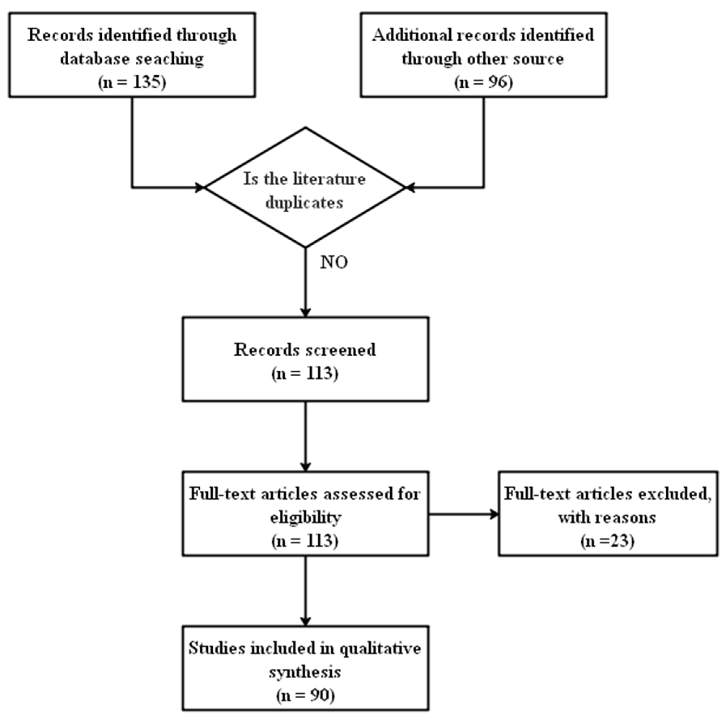
This research conducted a systematic review following the PRISMA framework to obtain a comprehensive understanding of how BIM/GIS technology is utilized on bridges. Data for this systematic review were sourced mainly from Scopus because of its broad coverage of interdisciplinary research. Google Scholar, a powerful web search engine, functioned as a supplementary tool to eliminate searching biases. “Building Information Modelling” (BIM) or “Bridge Information Modelling” (BrIM); “Civil Information Modelling” (CIM), or “City Information Modelling” (CIM); “Geographical Information System” (GIS), and bridge constituted the primary keywords. The “AND” Boolean logic was used to search for combinations of the primary keywords in either the title, abstract or keyword fields of journal articles to capture a wide range of sources relevant to the applications of BIM and GIS technologies in bridge construction and management. The time frame for the review was set to the past ten years (2011–2020) since BIM/GIS technology is a relatively new area that is largely facilitated by the development of computer science. The publication type was limited to peer reviewed journal articles to ensure that high-quality state-of-the-art research was reviewed. Figure 1 presents details of the PRISMA framework implementation in this research. A total of 135 records were retrieved from Scopus and 96 from Google Scholar. The records retained for screening after removing duplicates was 124 journal articles. After screening titles and abstracts, 113 records were retained for full-text review as shown in Figure 1. Records were retained for detailed qualitative synthesis if they collected and analyzed BIM/GIS technology implementation data on bridges. A total of 90 publications were retained for detailed review following a full-text eligibility review.
To analyze these publications quantitatively, Table 1 lists journals where the reviewed papers were published, including top ranking journals such as Automation in Construction (AIC), Journal of Computing in Civil Engineering (JCCE), and Structure and Infrastructure Engineering (SIE). The paper distribution in terms of year and journal is illustrated in Table 1. The table shows a growing trend of research from 2011 to 2020. Table 1 also shows that the research on BIM technology (i.e., 58) is twice as much as GIS technology (i.e., 30). Only two studies investigated the combination of BIM and GIS for bridges.
3. Analysis
Bridge engineering involves many stages throughout its life cycle; each stage comprises multiple complex processes with large project teams and relies on the efficient exchange of information [24,25,26]. Table 2 shows the distribution of the reviewed studies with respect to planning and design, construction, operation and maintenance, and information exchange for the last decade.
3.1. Planning and Design
Because GIS technology has the function of a macro layout, it is often used in the regional level and above scenes, as Table 3 shows that the application of GIS technology in bridge engineering at the planning stage mainly involved making need-based decisions for planning new bridges [6,66,67] to improve transportation infrastructure [6,66], traffic jam and pedestrian travel time [67]. Additionally, GIS technology combined with different multi-criteria decision-making methods were used in selecting the best geographic locations for new bridges [5] to minimize cost and also add value to the city image [4] and other benefits (e.g., tourism).
Table 3 also shows that use of BIM technology at the design stage of bridge engineering has focused mainly on developing and using 3D bridge models to inform design decisions. The authors of Refs. [11,23] used a 3D information model to analyze the assembling process of a bridge and suggested modifications. The authors of Refs. [1,2,3,8] conducted the parametric modeling of a bridge and suggested a design guideline for 3D information modelling to reduce collision and other modeling problems to enhance the accuracy of 3D model design. Three-dimensional information modeling can also be used to design aesthetically pleasing bridges [4]. The authors of Ref. [27] proposed that an integrated information management system at the conceptual design stage should become the new approach to informing downstream design (and construction) processes of bridge projects. Based on the powerful spatial data management and information processing ability of GIS, Ref. [68] constructed the evaluation model of highway engineering bearing capacity (HEBC) based on GIS, and effectively realized the evaluation of highway engineering bearing capacity.
3.2. Construction
Table 4 shows applications of BIM/GIS technology at the bridge construction stage from 18 studies. Among them, only one study [69] investigated the application of GIS technology combined with fuzzy logic in the selection of better bridge construction location in the construction process. At the construction stage, Table 4 shows that research on the application of BIM/GIS technology has focused mainly on construction cost [3,7,10,29,30], scheduling [1,3,7,9,10] and visualizing the construction process on site [1,2,8,9,31,32,33,34,35] and is not surprising, given that these are among the key issues that project managers will generally prioritize at the constructions stage of all projects, including bridges. However, the table also shows the use of BIM/GIS technology for other complex tasks at the construction stage, including coordination [9,11], optimizing constructability [21,69], and tracking GHG emissions [69].
Project participants used BIM technology to calculate the required earth filling [53,54], timely visualize of risk factors [8], select the best crane position through the visualization [21], minimize rework [7,10], track project schedule [1,3,7,9,10], and to finally reduce construction cost [3,7,10,29,30]. BIM can also generate as-built CAD drawings from as-built BIM models [2] and export them.
3.3. Operation and Maintenance
Table 5 shows the operation and maintenance applications of BIM/GIS technology in bridge projects from 41 studies. Among them, only one study [15] focused on the bridge management system (BMS) and investigated the application of BIM and GIS technologies to realize several maintenance functions, including information management, bridge detection, condition evaluation, repair and reinforcement, multi-scale visualization, and collaborative management. At present, GIS technology is mainly used for tracking bridge traffic networks [13,70,71,72,73,74,75,76]. This traffic network can be leveraged by disaster response systems to determine the location of the affected bridge [14,77,78] and coordinate the timely arrival of first responders, such as firefighters [70], to minimize disaster-related losses [13,74].
For the operation and maintenance stage, Table 5 shows that the bridge management personnel developed BMS [12,14,15,16,17,36,44,45,51,52,73,77,78,84,85,86] based on BIM/GIS technology to facilitate bridge inspection/monitoring [14,34,37,38,39,40,43,44,47,48,49,50,51,77,78,79,80,81], bridge evaluation [12,14,16,34,37,38,41,42,43,44,45,48,49,50,52,73,75,77,78,81,85], bridge maintenance decision making [43,46,51,52,82,83] and bridge structural health recovery [14,39,45,71,72]. Bridge operation and maintenance management personnel collect timely data through monitoring equipment or manually. The data are then transferred to bridge management systems. In the system, the collected data are processed first [50] and then used for a bridge health assessment to inform operation and maintenance decisions. After completing the maintenance action, a revised bridge health status can be fed back to the bridge management system.
3.4. Information Exchange
Table 6 shows the applications of BIM/GIS technology at all stages of the bridge information exchange from 25 studies. Among them, two studies [15,90] investigated the integration of BIM and GIS technologies, Ref. [15] proposed the necessary IFC and IFD standards as the premise of unifying bridge maintenance information, and Ref. [90] realized the conversion from an IFC (BIM) to a Shapefile (GIS) through an open source algorithm. There is no standard extension of GIS in the collected literature. Table 6 shows that bridge managers operate with bridge information models based on extended standard [15,19,20,55,56], data integration [18,19,36,41,44,57,58,59,60,87,88,90] and interoperability [11,22,46,60,61,62,63,64,65,79,90]. In order to better realize the application of BIM/GIS technology in the field of bridge engineering, researchers first compile bridge BIM/IFC standards according to the requirements of bridge maintenance [19] or expand BIM/IFC in the existing standard [15,20,55,56] and gradually integrate BIM/GIS data before developing an advanced algorithm to interact with BIM/GIS data.
4. Discussion and Future Work
BIM and GIS modelling are new techniques that require further investigation to discover their potential benefits for all stakeholders [91,92]. The integration of both technologies is expected to revolutionize digital design in the Architecture Engineering Construction (AEC) industry [10,93]. Table 7 shows the challenges and potential solutions for the effective application of BIM/GIS technology in the bridge sub-industry of AEC based on synthesis of the limitations of the application of BIM/GIS technology from the current body of knowledge. The following four subsections expand these challenges and suggest potential solutions.
4.1. Planning and Design
It was found that most practitioners only considered BIM as a display tool and some of them had no idea about BIM [1]. With the increase in population and the evolving complexity of structural design [4], there is the need to improve practitioners’ knowledge and application of BIM/GIS technology [1] to enhance the application of BIM/GIS technology at the design stage of bridge projects [4,6,11,66].
The design institutions need to regularly train and assess practitioners in the application of BIM/GIS technology [1]. At present, efforts are being made to expand the probabilistic and numerical model database of bridges, which is an important step towards formulating reasonable design rules for bridge components [27]. This can be achieved through close cooperation between key stakeholders, including architects [4], landscape designers and urban planners.
4.2. Construction
The application of BIM/GIS technology in the bridge construction process in various countries is increasing. This can promote effective and efficient management of the construction processes and contribute to further development of BIM/GIS technology for the AEC industry and particularly, the bridge sub-industry. However, there are several technical and practical problems that need to be resolved to enhance the application process of these technologies.
About 70% of the negative cost impact of some bridge construction projects may be related to the first implementation of BIM/GIS technology during construction [7]. Some bridge construction projects use BIM technology to evaluate cost inaccuracies [28,29,30], such as estimates limited to direct costs only [29]. Moreover, due to the lack of BIM/GIS knowledge of bridge project participants [1], the efficiency and effectiveness of BIM/GIS technology implementation may be negatively affected [3,7]. It is gratifying that the visualization of BIM/GIS technology can enhance project cognition and communication among participants in the process of bridge construction [9]; however, only a limited number of bridge projects have implemented BIM/GIS technology [9,21,28,30,69].
It is difficult to completely isolate the impact of BIM/GIS implementation, because no two construction projects are identical [7]. However, in the future, when BIM/GIS technology is used at the construction stage of bridge projects, appropriate BIM/GIS training could be conducted for participants to enhance implementation [1]. Methods of cost estimation can be continuously explored to enhance cost efficiency [28,29,30] by covering most indirect costs [29] so as to reduce the negative cost impact of BIM/GIS technology implementation. BIM/GIS technology implemented on existing bridges for functions such as maintenance management to aid further adaptation of these technologies for bridges and continuous improvement of the application process.
4.3. Operation and Maintenance
At present, the existing bridge transportation network models based on GIS usually adopt deterministic [71,72] or static traffic flow patterns [76], without considering the influence of other factors, such as wind intensity [70]. The benefits of GIS technology in the management of major transportation facilities have not been verified [13,74]. BIM/GIS models for bridge management have poor compatibility with other models or modules such as the finite element model [15,39,40], damage model [16], and disaster model [14,77,78] and, therefore, influences data mining. There is a growing trend using UAV and other detection technologies for bridge detection based on BIM/GIS [94]. Although these technologies have many benefits, there are some shortcomings, including the lack of overall perspective [41,42] and the impact of weather changes on data quality [14,34,37,38,77,78]; these can affect bridge evaluation outcomes [73]. Therefore, the existing evaluation models may not be directly applicable to other projects [48,49,52,81], given that they may negatively affect maintenance decisions of other bridges.
In the future, researchers could consider introducing uncertainty [71,72] or a dynamic traffic flow [76] and other factors to improve bridge transportation network models based on GIS to enhance model utility and expand the scope of application. BIM/GIS software, including API, should be further developed to improve their compatibility with other models or modules and enhance data mining for bridge management systems [15,39,40,95]. It is suggested to improve the quality of bridge detection by adding acquisition methods such as omnidirectional acquisition [41,42] and improving data processing methods. In terms of bridge maintenance decision making, more researchers and decision makers need to study and verify different bridge maintenance decision-making objectives and constraints [51], and combine with BIM/GIS technology to improve decision making.
4.4. Information Exchange
As a research prototype, bridge information models, in their current state, consider only a few standards and applications. Many data entities, which are necessary to fully support other bridge monitoring and management applications, are lacking [36]. Although BIM based on the IFC data model is the core of information interoperability, due to the lack of IFC support for bridge structure [19,36,44,59] and the target classification depending on the quality of the geometric model [55], it is still not enough to realize a real BIM model [19]. Some existing bridges lack digital drawings and even paper drawings [57,58]; hence, most of the data transmission needs to be manual [18,33,34,35] which would affect the efficiency of BIM/GIS integration [20,90]. BIM/GIS models have inconsistent data exchange format [41,63] and a slow information feedback speed [77], which affect interoperability between models. The poor interoperability of BIM/GIS software may hinder effective development of related software [22,41,60,61,62,63,64,65].
Regarding future work, it is important to clarify and pinpoint the requirements that each domain sets, especially if BIM-GIS integration (e.g., geometry conversion [20] and semantic mapping [20,55]) are to be addressed [20]. It is suggested that researchers could develop a more accurate bridge information model with detailed parameter information and determine the model development specifications of existing bridges to meet the needs of stakeholders [34]. It is very important to compare BIM standards (such as IFC) with the infrastructure module of GIS standards (such as CityGML) to determine the most favorable integration degree of these two fields in the field of asset management [15,20,90]. When using BIM/GIS technology, managers need to pay more attention to the use of interoperable and open data exchange formats [41] to enhance the operational efficiency of the platform.
5. Conclusions
There has been increasing interest in the bridge engineering community to use BIM and GIS for the efficient, automated and intelligent handling of different aspects of bridge projects. This research reviewed a total of 90 journal papers over the past decade and summarized the state-of-the-art applications of BIM and GIS technologies in different aspects of bridge projects (i.e., planning and design, construction, operation and maintenance as well as information exchange). Accordingly, the main challenges were identified and future work is recommended based on the following key aspects: (1) Develop BIM and GIS standards to solve the problems of bridge BIM-GIS data integration and interaction method. (2) During the planning and design stage, it is necessary to formulate standardized bridge design modeling protocols and terms to solve the problems of bridge modeling design. (3) During the construction stage, try to use BIM technology to optimize new construction processes and improve the construction schedule, as well as reasonable methods for cost estimation could be continuously explored. (4) During the operations and maintenance phase, the requirements of each management department should be clarified and identified, as well as omnidirectional data acquisition methods should be explored further to enhance the efficiency of managers in decision making. Findings of this research would serve as a guide for bridge engineering practitioners in selecting appropriate BIM/GIS technology for different phases of bridge projects. Additionally, findings of this review would contribute to further research and development to improve the application of BIM/GIS technology on bridge projects.
Author Contributions
Conceptualization, J.W. (Jiangang Wei) and J.H.; methodology, J.W. (Jun Wang), L.X., Y.Y. and G.C.; writing—original draft preparation, G.C.; writing—review and editing, J.W. (Jun Wang) and A.-M.S.; supervision, J.W. (Jiangang Wei) and J.H.; funding acquisition, J.W. (Jiangang Wei) and J.W. (Jun Wang). All authors have read and agreed to the published version of the manuscript.
Funding
This research was funded by the National Natural Science Foundation (Grant No. 51878172), Australian Research Council’s Linkage Project funding scheme (project LP180100222), university industry research cooperation project in Fujian Province (Grant No. 2019H6020), and The Program for Innovative Research Teams in Science and Technology in Fujian Province University.
Institutional Review Board Statement
Not applicable.
Informed Consent Statement
Not applicable.
Conflicts of Interest
On behalf of all authors, the corresponding author states that there is no conflict of interest.
References
- Liu, W.P.; Guo, H.L.; Li, H.; Li, Y. Using BIM to Improve the Design and Construction of Bridge Projects: A Case Study of a Long-span Steel-box Arch Bridge Project. Int. J. Adv. Robot Syst. 2014, 11, 125. [Google Scholar] [CrossRef]
- Shim, C.S.; Yun, N.R.; Song, H.H. Application of 3D Bridge Information Modeling to Design and Construction of Bridges. Procedia Eng. 2011, 14, 95–99. [Google Scholar] [CrossRef] [Green Version]
- Lee, K.M.; Lee, Y.B.; Shim, C.S.; Park, K.L. Bridge information models for construction of a concrete box-girder bridge. Struct. Infrastruct. Eng. 2012, 8, 687–703. [Google Scholar] [CrossRef]
- Tanner, P.; Bellod, J.L.; Sanz, D. Paper and Pencil in the Age of BIM. Struct. Eng. Int. 2018, 28, 396–407. [Google Scholar] [CrossRef]
- Zagorskas, J.; Turskis, Z. Location Preferences of New Pedestrian Bridges Based on Multi-Criteria Decision-Making and GIS-Based Estimation. Balt. J. Road Bridge Eng. 2020, 15, 158–181. [Google Scholar] [CrossRef]
- Jaro, T.S.; Iguisi, M.P. Development of GIS-Based Road Transport Information Management System for Adamawa Central, Adamawa State, Nigeria. J. Inf. Eng. Appl. 2015, 5, 57–73. [Google Scholar]
- Fanning, B.; Clevenger, C.M.; Ozbek, M.E.; Mahmoud, H. Implementing BIM on Infrastructure: Comparison of Two Bridge Construction Projects. Pract. Period. Struct. Des. Constr. 2015, 20, 04014044. [Google Scholar] [CrossRef]
- Shim, C.S.; Lee, K.M.; Kang, L.S.; Hwang, J.; Kim, Y. Three-Dimensional Information Model-Based Bridge Engineering in Korea. Struct. Eng. Int. 2012, 22, 8–13. [Google Scholar] [CrossRef]
- Vilventhan, A.; Rajadurai, R. 4D Bridge Information Modelling for management of bridge projects: A case study from India. Built Environ. Proj. Asset Manag. 2020, 10, 423–435. [Google Scholar] [CrossRef]
- Sakdirat, K.; Jessada, S.; Zhihao, Z. Sustainability-Based Lifecycle Management for Bridge Infrastructure Using 6D BIM. Sustainability 2020, 12, 2436. [Google Scholar]
- Dang, N.S.; Rho, G.T.; Shim, C.S. A Master Digital Model for Suspension Bridges. Appl. Sci. 2020, 10, 7666. [Google Scholar] [CrossRef]
- Xiaochen, D.; Haixia, L.; Tianming, H.; Luhai, L.; Kai, W. Research on the 3D Nonlinear Intelligent Control for Bridge Engineering Operation and Maintenance Cost. J. Railw. Eng. Soc. 2020, 37, 102–107. [Google Scholar]
- Ford, M.; Kirkman, R.; Cox, J.; Ringeisen, D. Benefits of Geographic Information Systems in Managing a Major Transportation Program Evaluation and Lessons Learned. Transp. Res. Rec. J. Transp. Res. Board 2012, 2291, 1–7. [Google Scholar] [CrossRef]
- Yang, L.; Qian, Z. Design of urban bridge health monitoring system based on internet of things and gis. J. Geomat. 2019, 44, 19–22. [Google Scholar]
- Wan, C.; Zhou, Z.; Li, S.; Ding, Y.; Xu, Z.; Yang, Z.; Xia, Y.; Yin, F. Development of a Bridge Management System Based on the Building Information Modeling Technology. Sustainability 2019, 11, 4583. [Google Scholar] [CrossRef] [Green Version]
- Ren, G.; Ding, R.; Li, H. Building an ontological knowledgebase for bridge maintenance. Adv. Eng. Softw. 2019, 130, 24–40. [Google Scholar] [CrossRef]
- Changsu, S.; Hwirang, K.; Son, D.N.; Deokkeun, L. Development of BIM-based bridge maintenance system for cable-stayed bridges. Smart Struct. Syst. 2017, 20, 697–708. [Google Scholar]
- Hong, J.H.; Kuo, C.L. A semi-automatic lightweight ontology bridging for the semantic integration of cross-domain geospatial information. Int. J. Geogr. Inf. Sci. 2015, 29, 2223–2247. [Google Scholar] [CrossRef]
- Park, S.; Park, J.; Kim, B.G.; Lee, S.H. Improving Applicability for Information Model of an IFC-Based Steel Bridge in the Design Phase Using Functional Meanings of Bridge Components. Appl. Sci. 2018, 8, 2531. [Google Scholar] [CrossRef] [Green Version]
- Floros, G.S.; Boyes, G.; Owens, D.; Ellul, C. Developing ifc for infrastructure: A case study of three highway entities. ISPRS Ann. Photogramm. Remote Sens. Spat. Inf. Sci. 2019, IV-4, 59–66. [Google Scholar] [CrossRef] [Green Version]
- Mohamed, M.; Mohamed, H. A hybrid model for selecting location of mobile cranes in bridge construction projects. Balt. J. Road Bridge Eng. 2013, 8, 184–189. [Google Scholar]
- Chan, B.; Guan, H.; Hou, L.; Jo, J.; Blumenstein, M.; Wang, J. Defining a conceptual framework for the integration of modelling and advanced imaging for improving the reliability and efficiency of bridge assessments. J. Civ. Struct. Health 2016, 6, 703–714. [Google Scholar] [CrossRef] [Green Version]
- Kirsi, H.; Matti-Esko, J.; Pekka, P. Digitalization transforms the construction sector throughout asset’s life-cycle from design to operation and maintenance. Stahlbau 2017, 86, 340–345. [Google Scholar]
- O’Keeffe, A. The State of the Art of Bridge Information Modelling from Conceptual Design through to Operation. IJ3DIM 2014, 3, 29–39. [Google Scholar] [CrossRef] [Green Version]
- Costin, A.; Adibfar, A.; Hu, H.; Chen, S.S. Building Information Modeling (BIM) for transportation infrastructure-Literature review, applications, challenges, and recommendations. Automat. Constr. 2018, 94, 257–281. [Google Scholar] [CrossRef]
- Cheng, J.C.P.; Lu, Q.; Deng, Y. Analytical review and evaluation of civil information modeling. Automat. Constr. 2016, 67, 31–47. [Google Scholar] [CrossRef]
- Markiz, N.; Jrade, A. Integrating fuzzy-logic decision support with a bridge information management system (BrIMS) at the conceptual stage of bridge design. J. Inf. Technol. Constr. 2018, 23, 92–121. [Google Scholar]
- Markiz, N.; Jrade, A. Integrating a fuzzy-logic decision support system with bridge information modelling and cost estimation at conceptual design stage of concrete box-girder bridges. Int. J. Sustain. Built Environ. 2014, 3, 135–152. [Google Scholar] [CrossRef] [Green Version]
- Marzouk, M.; Hisham, M. Implementing earned value management using bridge information modeling. KSCE J. Civ. Eng. 2014, 18, 1302–1313. [Google Scholar] [CrossRef]
- Marzouk, M.; Hisham, M. Applications of Building Information Modeling in Cost Estimation of Infrastructure Bridges. IJ3DIM 2012, 1, 17–29. [Google Scholar] [CrossRef]
- Zou, Y.; Kiviniemi, A.; Jones, S.W.; Walsh, J. Risk Information Management for Bridges by Integrating Risk Breakdown Structure into 3D/4D BIM. KSCE J. Civ. Eng. 2019, 23, 467–480. [Google Scholar] [CrossRef]
- Zou, Y.; Kiviniemi, A.; Jones, S.W. Developing a tailored RBS linking to BIM for risk management of bridge projects. ECAM 2016, 23, 727–750. [Google Scholar] [CrossRef] [Green Version]
- Wang, Q.; Sohn, H.; Cheng, J.C.P. Automatic As-Built BIM Creation of Precast Concrete Bridge Deck Panels Using Laser Scan Data. J. Comput. Civ. Eng. 2018, 32, 04018011. [Google Scholar] [CrossRef]
- Xu, Y.; Turkan, Y. BrIM and UAS for bridge inspections and management. ECAM 2020, 27, 785–807. [Google Scholar] [CrossRef]
- Perry, B.J.; Guo, Y.; Atadero, R.; van de Lindt, J.W. Streamlined bridge inspection system utilizing unmanned aerial vehicles (UAVs) and machine learning. Measurement 2020, 164, 108048. [Google Scholar] [CrossRef]
- Jeong, S.; Hou, R.; Lynch, J.P.; Sohn, H.; Law, K.H. An information modeling framework for bridge monitoring. Adv. Eng. Softw. 2017, 114, 11–31. [Google Scholar] [CrossRef]
- Khaloo, A.; Lattanzi, D.; Cunningham, K.; Dell’Andrea, R.; Riley, M. Unmanned aerial vehicle inspection of the Placer River Trail Bridge through image-based 3D modelling. Struct. Infrastruct. Eng. 2018, 14, 124–136. [Google Scholar] [CrossRef]
- Odrobiňák, J.; Farbák, M.; Chromák, J.; Kortiš, J.; Gocál, J. Real Geometrical Imperfection of Bow-String Arches—Measurement and Global Analysis. Appl. Sci 2020, 10, 4530. [Google Scholar] [CrossRef]
- McGuire, B.; Atadero, R.; Clevenger, C.; Ozbek, M. Bridge Information Modeling for Inspection and Evaluation. J. Bridge Eng. 2016, 21, 1–9. [Google Scholar] [CrossRef]
- Nettis, A.; Saponaro, M.; Nanna, M. RPAS-Based Framework for Simplified Seismic Risk Assessment of Italian RC-Bridges. Buildings 2020, 10, 150. [Google Scholar] [CrossRef]
- Zixiao, Z.; Hesam, H.; Sarah, B.; Martin, F. 4D beyond construction: Spatio-temporal and life-cyclic modeling and visualization of infrastructure data. J. Inf. Technol. Constr. 2018, 23, 285–304. [Google Scholar]
- Kumar, P.A.; Phil, C. Infrastructure information management of bridges at local authorities in the UK. Infrastruct. Asset. Manag. 2018, 5, 120–131. [Google Scholar]
- Mawlana, M.; Vandatikhaki, F.; Doriani, A.; Hammad, A. Integrating 4D modeling and discrete event simulation for phasing evaluation of elevated urban highway reconstruction projects. Automat. Constr. 2015, 60, 25–38. [Google Scholar] [CrossRef]
- Dang, N.S.; Shim, C.S. BIM-based innovative bridge maintenance system using augmented reality technology. In CIGOS 2019, Innovation for Sustainable Infrastructure; Springer: Singapore, 2020; pp. 1217–1222. [Google Scholar]
- Boddupalli, C.; Sadhu, A.; Rezazadeh Azar, E.; Pattyson, S. Improved visualization of infrastructure monitoring data using building information modeling. Struct. Infrastruct. Eng. 2019, 15, 1247–1263. [Google Scholar] [CrossRef]
- Dang, N.S.; Shim, C.S. Bridge assessment for PSC girder bridge using digital twins model. In CIGOS 2019, Innovation for Sustainable Infrastructure; Springer: Singapore, 2020; pp. 1241–1246. [Google Scholar]
- Delgado, J.M.D.; Butler, L.; Brilakis, I.; Elshafie, M.; Middleton, C. Structural Performance Monitoring Using a Dynamic Data-Driven BIM Environment. J. Comput. Civ. Eng 2018, 32, 04018009. [Google Scholar] [CrossRef] [Green Version]
- Xia, Y. Research on dynamic data monitoring of steel structure building information using BIM. J. Eng. Des. Technol. 2020, 18, 1165–1173. [Google Scholar]
- Ma, S. Three-dimensional Laser Combined with BIM Technology for Building Modeling, Information Data Acquisition and Monitoring. Nonlinear Opt. Quantum Opt. 2020, 52, 191–203. [Google Scholar]
- Tu, Z. Research on Measuring Instrument of Bridge Building Bearing Capacity Based on Computer BIM Technology. J. Phys. Conf. Ser. 2020, 1574, 012110. [Google Scholar] [CrossRef]
- Almomani, H.; Almutairi, O.N. Life-cycle maintenance management strategies for bridges in kuwait. J. Environ. Treat. Tech. 2020, 8, 1556–1562. [Google Scholar]
- Yin, Z.H.; Li, Y.F.; Guo, J.; Li, Y. Integration Research and Design of the Bridge Maintenance Management System. Procedia Eng. 2011, 15, 5429–5434. [Google Scholar] [CrossRef] [Green Version]
- Kim, H.; Shen, Z.; Moon, H.; Ju, K.; Choi, W. Developing a 3D intelligent object model for the application of construction planning/simulation in a highway project. KSCE J. Civ. Eng. 2016, 20, 538–548. [Google Scholar] [CrossRef]
- Karaman, S.G.; Chen, S.S.; Ratnagaran, B.J. Three-Dimensional Parametric Data Exchange for Curved Steel Bridges. Transp. Res. Rec. J. Transp. Res. Board 2013, 2331, 27–34. [Google Scholar] [CrossRef]
- Sacks, R.; Ma, L.; Yosef, R.; Borrmann, A.; Daum, S.; Kattel, U. Semantic Enrichment for Building Information Modeling: Procedure for Compiling Inference Rules and Operators for Complex Geometry. J. Comput. Civ. Eng. 2017, 31, 04017062. [Google Scholar] [CrossRef]
- BIEŃ, J. Modelling of structure geometry in Bridge Management Systems. Arch. Civ. Mech. Eng. 2011, 11, 519–532. [Google Scholar] [CrossRef]
- Dušan, I.; Vladeta, S.; Matthias, T.; Rico, R.; Rade, H.; Jürgen, D. Bridge damage: Detection, IFC-based semantic enrichment and visualization. Automat. Constr. 2020, 112, 103088. [Google Scholar]
- Hüthwohl, P.; Brilakis, I.; Borrmann, A.; Sacks, R. Integrating RC Bridge Defect Information into BIM Models. J. Comput. Civ. Eng. 2018, 32, 04018013. [Google Scholar] [CrossRef]
- Davila Delgado, J.M.; Butler, L.J.; Gibbons, N.; Brilakis, I.; Elshafie, M.Z.; Middleton, C. Management of structural monitoring data of bridges using BIM. Bridge Eng. 2017, 170, 204–218. [Google Scholar] [CrossRef] [Green Version]
- Lee, J.H.; Park, J.J.; Yoon, H. Automatic Bridge Design Parameter Extraction for Scan-to-BIM. Appl. Sci. 2020, 10, 7346. [Google Scholar] [CrossRef]
- Sedek, M.; Serwa, A. Development of new system for detection of bridges construction defects using terrestrial laser remote sensing technology. Egypt. J. Remote Sens. Space Sci. 2016, 19, 273–283. [Google Scholar] [CrossRef] [Green Version]
- McKenna, T.; Minehane, M.; O’Keeffe, B.; O’Sullivan, G.; Ruane, K. Bridge information modelling (BrIM) for a listed viaduct. Bridge Eng. 2017, 170, 192–203. [Google Scholar] [CrossRef]
- Ali, N.; Chen, S.S.; Srikonda, R.; Hu, H. Development of Concrete Bridge Data Schema for Interoperability. Transp. Res. Rec. J. Transp. Res. Board 2014, 2406, 87–97. [Google Scholar] [CrossRef]
- Abbas, R.; Ebrahim, K. Video to BrIM: Automated 3D As-Built Documentation of Bridges. J. Perform. Constr. Facil. 2018, 32, 04018026. [Google Scholar]
- Lu, R.; Brilakis, I. Digital twinning of existing reinforced concrete bridges from labelled point clusters. Automat. Constr. 2019, 105, 102837. [Google Scholar] [CrossRef]
- Ziboon, A.R.T.; Qasim, Z.I.; Falih, K.T. Gis application to evaluate transportations network in nasiriyah city. J. Eng. Sustain. Dev. 2017, 21, 75–87. [Google Scholar]
- Almumaiz, M.O. Improvement of Transportation Network of Al-Muwaffaqiyah Town Using Gis. J. Eng. Dev. 2014, 18, 229–245. [Google Scholar]
- Liu, Y.L.; Xu, K.H. GIS for Highway Engineering Bearing Capacity Evaluation. J. Highw. Transp. Res. Dev. 2014, 8, 28–33. [Google Scholar] [CrossRef]
- Ardeshir, A.; Mohseni, N.; Behzadian, K.; Errington, M. Selection of a Bridge Construction Site Using Fuzzy Analytical Hierarchy Process in Geographic Information System. Arab. J. Sci. Eng. 2014, 39, 4405–4420. [Google Scholar] [CrossRef]
- Hojune, A.; Youngjin, C.; Hyuk, L.J.; Ik, J.Y.; Sik, K.J. Semiquantitative Fire Risk Grade Model and Response Plans on a National Highway Bridge. Adv. Civ. Eng. 2019, 2019, 1–13. [Google Scholar]
- Bernier, C.; Gidaris, I.; Balomenos, G.P.; Padgett, J.E. Assessing the Accessibility of Petrochemical Facilities during Storm Surge Events. Reliab. Eng. Syst. Safe 2019, 188, 155–167. [Google Scholar] [CrossRef]
- Mingfeng, H.; Yifan, W. Multi-scale simulation of time-varying wind fields for Hangzhou Jiubao Bridge during Typhoon Chan-hom. J. Wind. Eng. Ind. Aerod. 2018, 179, 419–437. [Google Scholar]
- Kappos, A.; Sextos, A.; Stefanidou, S.; Mylonakis, G.; Pitsiava, M.; Sergiadis, M. Seismic Risk of Inter-urban Transportation Networks. Procedia Econ. Financ. 2014, 18, 263–270. [Google Scholar] [CrossRef] [Green Version]
- Aydin, S.G.; Shen, G.; Pulat, P. A Retro-Analysis of I-40 Bridge Collapse on Freight Movement in the U.S. Highway Network using GIS and Assignment Models. Int. J. Transp. Sci. Technol. 2012, 1, 379–397. [Google Scholar] [CrossRef] [Green Version]
- Twumasi-Boakye, R.; Sobanjo, J.O. Resilience of Regional Transportation Networks Subjected to Hazard-Induced Bridge Damages. J. Transp. Eng. 2018, 144, 04018062. [Google Scholar] [CrossRef] [Green Version]
- Lethanh, N.; Adey, B.T.; Burkhalter, M. Determining an Optimal Set of Work Zones on Large Infrastructure Networks in a GIS Framework. J. Infrastruct. Syst. 2018, 24, 04017048. [Google Scholar] [CrossRef]
- Tsai, M.K.; Yau, N.J. Using mobile disaster response system in bridge management. J. Civ. Eng. Manag. 2014, 20, 737–745. [Google Scholar] [CrossRef]
- Al-Aamri, A.K.; Hornby, G.; Zhang, L.C.; Al-Maniri, A.A.; Padmadas, S.S. Mapping road traffic crash hotspots using GIS-based methods: A case study of Muscat Governorate in the Sultanate of Oman. Spat. Stat. 2021, 42, 100458. [Google Scholar] [CrossRef]
- Javadnejad, F.; Gillins, D.T.; Higgins, C.C.; Gillins, M.N. BridgeDex: Proposed Web GIS Platform for Managing and Interrogating Multiyear and Multiscale Bridge-Inspection Images. J. Comput. Civ. Eng 2017, 31, 04017061. [Google Scholar] [CrossRef]
- Liu, T.; Pan, Q.; Sanchez, J.; Sun, S.; Wang, N.; Yu, H. Prototype Decision Support System for Black Ice Detection and Road Closure Control. IEEE Intell. Transp. Syst. Mag. 2017, 9, 91–102. [Google Scholar] [CrossRef]
- Mehta, G.; Li, J.; Fields, R.T.; Lou, Y.; Jones, S. Safety Performance Function Development for Analysis of Bridges. J. Transp. Eng. 2015, 141, 04015010. [Google Scholar] [CrossRef]
- Contreras-Nieto, C.; Shan, Y.; Lewis, P.; Hartell, J.A. Bridge maintenance prioritization using analytic hierarchy process and fusion tables. Automat. Constr. 2019, 101, 99–110. [Google Scholar] [CrossRef]
- Shields, G.M. Resiliency Planning: Prioritizing the Vulnerability of Coastal Bridges to Flooding and Scour. Procedia Eng. 2016, 145, 340–347. [Google Scholar] [CrossRef] [Green Version]
- Yoon, S.; Kim, J.; Kim, M.; Tak, H.Y.; Lee, Y.J. Accelerated System-Level Seismic Risk Assessment of Bridge Transportation Networks through Artificial Neural Network-Based Surrogate Model. Appl. Sci 2020, 10, 6476. [Google Scholar] [CrossRef]
- Wattan, S.A.A.; Al-Bakri, M. Development of Bridges Maintenance Management System based on Geographic Information System Techniques. J. Eng. 2019, 25, 232. [Google Scholar] [CrossRef] [Green Version]
- Weber, J. Route change on the American freeway system. J. Transp. Geogr. 2018, 67, 12–23. [Google Scholar] [CrossRef]
- Dabous, S.A.; Yaghi, S.; Alkass, S.; Moselhi, O. Concrete bridge deck condition assessment using IR Thermography and Ground Penetrating Radar technologies. Automat. Constr. 2017, 81, 340–354. [Google Scholar] [CrossRef]
- Vaghefi, K.; Ahlborn, T.M.; Harris, D.K.; Brooks, C.N. Combined Imaging Technologies for Concrete Bridge Deck Condition Assessment. J. Perform. Constr. Facil. 2015, 29, 04014102. [Google Scholar] [CrossRef]
- Fisher, R.; Heckbert, S.; Villalobos, J.M.L.; Sutton, S. Augmenting physical 3D models with projected information to support environmental knowledge exchange. Appl. Geogr. 2019, 112, 102095. [Google Scholar] [CrossRef]
- Junxiang, Z.; Xiangyu, W.; Peng, W.; Zhiyou, W.; Mi Jeong, K. Integration of BIM and GIS: Geometry from IFC to shapefile using open-source technology. Automat. Constr. 2019, 102, 105–119. [Google Scholar]
- Chong, H.Y.; Lopez, R.; Wang, J.; Wang, X.; Zhao, Z. Comparative analysis on the adoption and use of BIM in road infrastructure projects. J. Manag. Eng. 2016, 32, 05016021. [Google Scholar] [CrossRef]
- Wang, J.; Sun, W.; Shou, W.; Wang, X.; Wu, C.; Chong, H.Y.; Liu, Y.; Sun, C. Integrating BIM and LiDAR for real-time construction quality control. J. Intel. Robot. Syst. 2015, 79, 417–432. [Google Scholar] [CrossRef]
- Zhu, J.; Wright, G.; Wang, J.; Wang, X. A critical review of the integration of geographic information system and building information modelling at the data level. ISPRS Int. J. Geo-Inform. 2018, 7, 66. [Google Scholar] [CrossRef] [Green Version]
- Xu, S.; Wang, J.; Shou, W.; Ngo, T.; Sadick, A.M.; Wang, X. Computer vision techniques in construction: A critical review. Arch. Comput. Methods Eng. 2020, 1–15. [Google Scholar] [CrossRef]
- Tsai, Y.H.; Wang, J.; Chien, W.T.; Wei, C.Y.; Wang, X.; Hsieh, S.H. A BIM-based approach for predicting corrosion under insulation. Automat. Constr. 2019, 107, 102923. [Google Scholar] [CrossRef]
Figure 1.
PRISMA flow diagram.


Table 1.
Paper distribution in terms of journal and year of publication and BIM/GIS.
| Journals | Sum | 2011 | 2012 | 2013 | 2014 | 2015 | 2016 | 2017 | 2018 | 2019 | 2020 |
|---|---|---|---|---|---|---|---|---|---|---|---|
| AIC | 8 | 1 | 1 | 1 | 1 | 3 | 1 | ||||
| JCCE | 5 | 2 | 3 | ||||||||
| AS | 5 | 1 | 4 | ||||||||
| SIE | 3 | 1 | 1 | 1 | |||||||
| KSCE JCE | 3 | 1 | 1 | 1 | |||||||
| TRR JTRB | 3 | 1 | 1 | 1 | |||||||
| PE | 3 | 2 | 1 | ||||||||
| AES | 2 | 1 | 1 | ||||||||
| Sustainability | 2 | 1 | 1 | ||||||||
| JPCF | 2 | 1 | 1 | ||||||||
| ECAM | 2 | 1 | 1 | ||||||||
| SEI | 2 | 1 | 1 | ||||||||
| BJRBE | 2 | 1 | 1 | ||||||||
| JTE | 2 | 1 | 1 | ||||||||
| BE | 2 | 2 | |||||||||
| ITcon | 2 | 2 | |||||||||
| LNCE | 2 | 2 | |||||||||
| IJ3DIM | 2 | 1 | 1 | ||||||||
| RESS | 1 | 1 | |||||||||
| Measurement | 1 | 1 | |||||||||
| ACME | 1 | 1 | |||||||||
| JWEIA | 1 | 1 | |||||||||
| IJGIS | 1 | 1 | |||||||||
| SSS | 1 | 1 | |||||||||
| JCSHM | 1 | 1 | |||||||||
| JBE | 1 | 1 | |||||||||
| IEEE ITSM | 1 | 1 | |||||||||
| JCEM | 1 | 1 | |||||||||
| Stahlbau | 1 | 1 | |||||||||
| IJARS | 1 | 1 | |||||||||
| ACE | 1 | 1 | |||||||||
| AJSE | 1 | 1 | |||||||||
| PPSDC | 1 | 1 | |||||||||
| BEPAM | 1 | 1 | |||||||||
| JOE | 1 | 1 | |||||||||
| EJRSSS | 1 | 1 | |||||||||
| IJSBE | 1 | 1 | |||||||||
| PEF | 1 | 1 | |||||||||
| JHTRD | 1 | 1 | |||||||||
| IAM | 1 | 1 | |||||||||
| ISPRS APRSSI | 1 | 1 | |||||||||
| JIEA | 1 | 1 | |||||||||
| JED | 1 | 1 | |||||||||
| Buildings | 1 | 1 | |||||||||
| JRES | 1 | 1 | |||||||||
| JEDT | 1 | 1 | |||||||||
| JETT | 1 | 1 | |||||||||
| JPCS | 1 | 1 | |||||||||
| NOQO | 1 | 1 | |||||||||
| SS | 1 | 1 | |||||||||
| JG | 1 | 1 | |||||||||
| AG | 1 | 1 | |||||||||
| JIS | 1 | 1 | |||||||||
| JTG | 1 | 1 | |||||||||
| JESD | 1 | 1 | |||||||||
| Sum | 90 | 3 | 5 | 2 | 10 | 6 | 7 | 10 | 15 | 13 | 19 |
| BIM and GIS | 2 | 2 | |||||||||
| BIM | 58 | 2 | 3 | 2 | 5 | 2 | 6 | 6 | 11 | 5 | 16 |
| GIS | 30 | 1 | 2 | 5 | 4 | 1 | 4 | 4 | 6 | 3 | |
| Sum | 90 | 3 | 5 | 2 | 10 | 6 | 7 | 10 | 15 | 13 | 19 |
Table 2.
Literature distribution of BIM/GIS applications at different stages of bridge engineering.
| Technology | Planning and Design | Construction | Operation and Maintenance | Information Exchange |
|---|---|---|---|---|
| BIM | [1,2,3,4,8,11,23,27] | [1,2,3,7,8,9,10,11,21,28,29,30,31,32,33,34,35] | [12,16,17,34,36,37,38,39,40,41,42,43,44,45,46,47,48,49,50,51,52] | [11,19,20,22,36,41,44,46,53,54,55,56,57,58,59,60,61,62,63,64,65] |
| GIS | [5,6,66,67,68] | [69] | [13,14,70,71,72,73,74,75,76,77,78,79,80,81,82,83,84,85,86] | [18,77,87,88,89] |
| BIM and GIS | [15] | [15,90] |
Table 3.
BIM/GIS uses in planning and design.
| Examples | Application Type | Key Outcome | Limitations |
|---|---|---|---|
| Technology: BIM | |||
| [1] | Error/clash detection |
|
|
| [2] | Parametric modeling |
|
|
| [3,8] | Parametric modeling, simulation, visualization |
|
|
| [4] | Aesthetic |
|
|
| [11] | Design model integration |
|
|
| [23] | Visualization |
|
|
| [27] | Parametric analysis |
|
|
| [28] | Conceptually plan |
|
|
| Technology: GIS | |||
| [5] | Bridge location |
|
|
| [6,66] | Road transport information management system |
|
|
| [67] | Transportation network |
|
|
| [68] | Evaluation |
|
|
Table 4.
BIM/GIS uses in construction.
| Examples | Application Type | Key Outcome | Limitations |
|---|---|---|---|
| Technology: BIM | |||
| [1] | Construction schedule |
|
|
| [2] | Produce shop drawing |
|
|
| [3] | Construction schedule |
|
|
| [7] | Construction schedule, rework |
|
|
| [8] | Risk factor |
|
|
| [9] | Construction sequence, schedule |
|
|
| [10] | Rework |
|
|
| [21] | Crane location |
|
|
| [29] | Budget, schedule |
|
|
| [30] | Cost estimate, review estimate |
|
|
| [31,32] | Risk location |
|
|
| [33,34,35] | Estimate dimension |
|
|
| [53,54] | Earth filling |
|
|
| Technology: GIS | |||
| [69] | Bridge construction site |
|
|
Table 5.
BIM/GIS uses in operation and maintenance.
| Examples | Application Type | Key Outcome | Limitations |
|---|---|---|---|
| Technology: BIM | |||
| [12] | Operation and maintenance cost |
|
|
| [16] | Automatic rule checking |
|
|
| [17,36] | Operation and maintenance cost |
|
|
| [34,37,38] | 3D in situ modelling |
|
|
| [39,40] | Bridge evaluation |
|
|
| [41,42] | Maintenance scheduling |
|
|
| [43] | Bridge evaluation |
|
|
| [44] | Bridge inspection |
|
|
| [45] | Bridge evaluation |
|
|
| [46] | React to unexpected situation |
|
|
| [47] | Bridge monitoring |
|
|
| [48,49] | Bridge monitoring |
|
|
| [50] | Imaging processing |
|
|
| [51] | Bridge Management System (BMS) |
|
|
| Technology: GIS | |||
| [13,74] | Benefit-cost |
|
|
| [14,78] | Disaster response system |
|
|
| [70] | Fire alarm time |
|
|
| [71,72] | Bridge evaluation |
|
|
| [73] | Bridge evaluation |
|
|
| [75] | Bridge evaluation |
|
|
| [76] | BMD |
|
|
| [77] | Disaster response system |
|
|
| [79] | BMS |
|
|
| [80] | Bridge Maintenance Decision (BMD) |
|
|
| [81] | Bridge inspection |
|
|
| [82,83] | BMD |
|
|
| [52] | BMS |
|
|
| [84] | Bridge evaluation |
|
|
| [85] | BMS |
|
|
| [86] | BMD |
|
|
| Technology: BIM and GIS | |||
| [15] | BMS |
|
|
Table 6.
BIM/GIS uses in information exchange.
| Examples | Application Type | Key Outcome | Limitations |
|---|---|---|---|
| Technology: BIM | |||
| [11] | Interoperability |
|
|
| [19] | IFC standard |
|
|
| [20] | IFC expansion |
|
|
| [22,60,61,62,64,65] | Interoperability |
|
|
| [36,44,59] | Storage, sharing, utilization |
|
|
| [41] | Data integration |
|
|
| [46] | Interoperability |
|
|
| [55] | Expand standard |
|
|
| [56] | Expand standard |
|
|
| [57,58] | Data integration |
|
|
| [63] | Interoperability |
|
|
| Technology: GIS | |||
| [18] | Data integration |
|
|
| [87,88] | Data integration |
|
|
| [89] | Interoperability |
|
|
| Technology: BIM and GIS | |||
| [15] | IFC expansion |
|
|
| [90] | Interoperability, data integration |
|
|
Table 7.
Challenges corresponding to the four aspects of analysis and potential solutions.
| Application Aspects | Contents | Challenge | Potential Solution |
|---|---|---|---|
| Planning and design | Planning: Plan roads (bridges), find bridge site. Design: Establish bridge 3D information design model. |
|
|
| Construction | Cost, schedule. |
|
|
| Operation and maintenance | Bridge traffic network, bridge management system, bridge inspection, bridge evaluation, bridge maintenance decision. |
|
|
| Information exchange | Expand standard, data integration, interoperability. |
|
|
Publisher’s Note: MDPI stays neutral with regard to jurisdictional claims in published maps and institutional affiliations. |
© 2021 by the authors. Licensee MDPI, Basel, Switzerland. This article is an open access article distributed under the terms and conditions of the Creative Commons Attribution (CC BY) license (https://creativecommons.org/licenses/by/4.0/).
Share and Cite
MDPI and ACS Style
Wei, J.; Chen, G.; Huang, J.; Xu, L.; Yang, Y.; Wang, J.; Sadick, A.-M. BIM and GIS Applications in Bridge Projects: A Critical Review. Appl. Sci. 2021, 11, 6207. https://0-doi-org.brum.beds.ac.uk/10.3390/app11136207
AMA Style
Wei J, Chen G, Huang J, Xu L, Yang Y, Wang J, Sadick A-M. BIM and GIS Applications in Bridge Projects: A Critical Review. Applied Sciences. 2021; 11(13):6207. https://0-doi-org.brum.beds.ac.uk/10.3390/app11136207
Chicago/Turabian StyleWei, Jiangang, Gang Chen, Jizhuo Huang, Li Xu, Yan Yang, Jun Wang, and Abdul-Manan Sadick. 2021. "BIM and GIS Applications in Bridge Projects: A Critical Review" Applied Sciences 11, no. 13: 6207. https://0-doi-org.brum.beds.ac.uk/10.3390/app11136207
Note that from the first issue of 2016, this journal uses article numbers instead of page numbers. See further details here.