
A Comprehensive and Effective Framework for Traffic Congestion Problem Based on the Integration of IoT and Data Analytics

 , , and
Abstract
:1. Introduction
- 1
- A review of the literature related to traffic congestion.
- 2
- A comprehensive framework for a reliable, flexible, and efficient solution for traffic congestion problems.
- 3
- An algorithm for traffic lights for the efficient management of congestion at intersections and the evaluation of its efficiency.
- 4
- An algorithm for the classification of tweets and the detection of congestion in a particular area and the evaluation of its accuracy.
- 5
- An accuracy evaluation of an image-processing algorithm for congestion detection from images captured by drones.
2. Related Work
3. Proposed Framework
3.1. Sensing Layer
3.2. Fog Layer
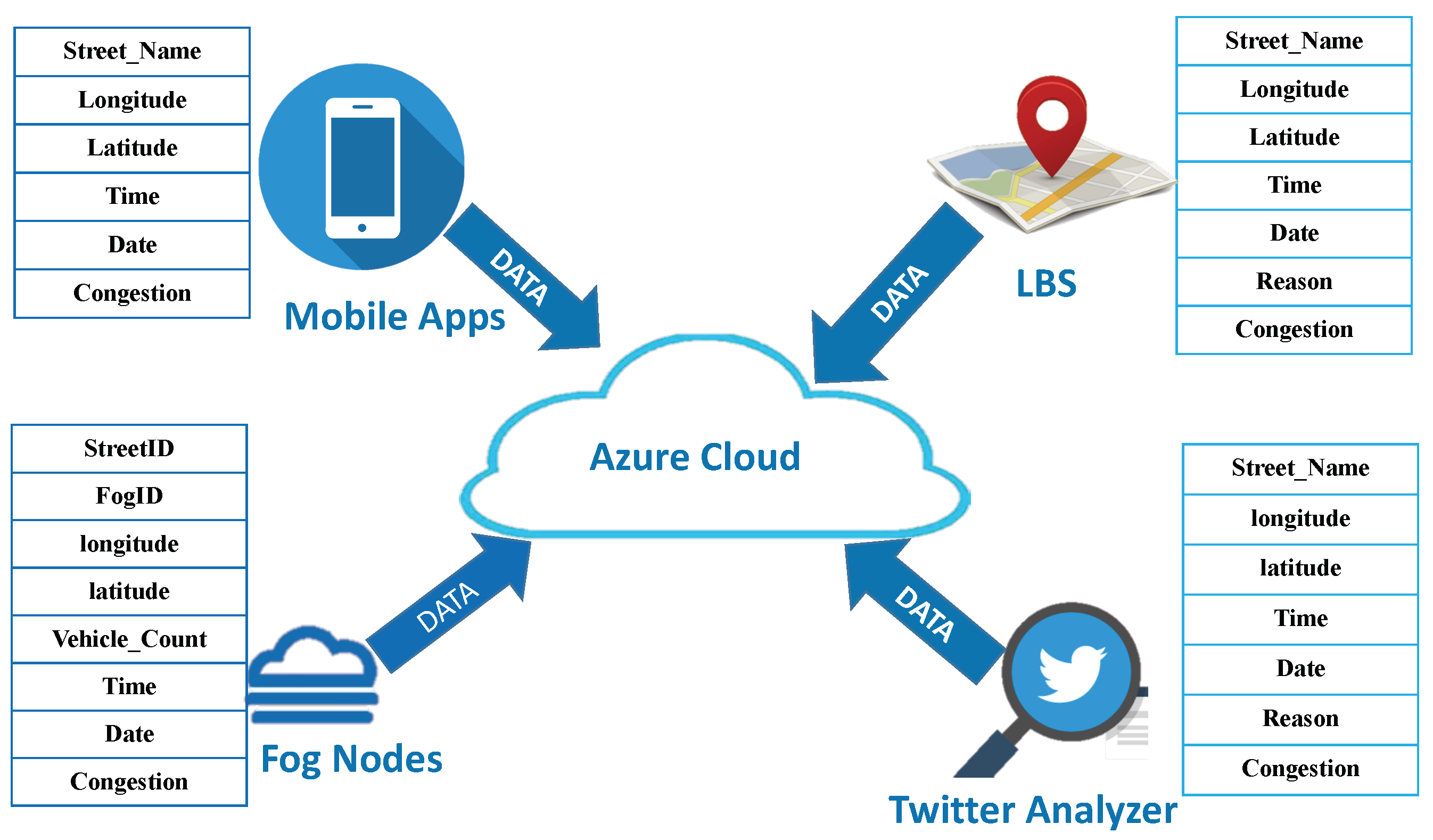
3.3. Cloud Layer
3.4. Services/Applications Layer
4. Functional Model of the Framework
4.1. Level 1—Traffic Congestion at Intersections
- Listing 1.
- Proposed algorithm for a smart traffic light (STL).

4.2. Level 2—Traffic Congestion on Main Streets
- Using information from service providers, such as Google Maps, OpenStreetMap, and so on, to determine the traffic status of streets and the degree of congestion, without specifying the cause or type of congestion. In our implementation of the framework, we used Google Maps.
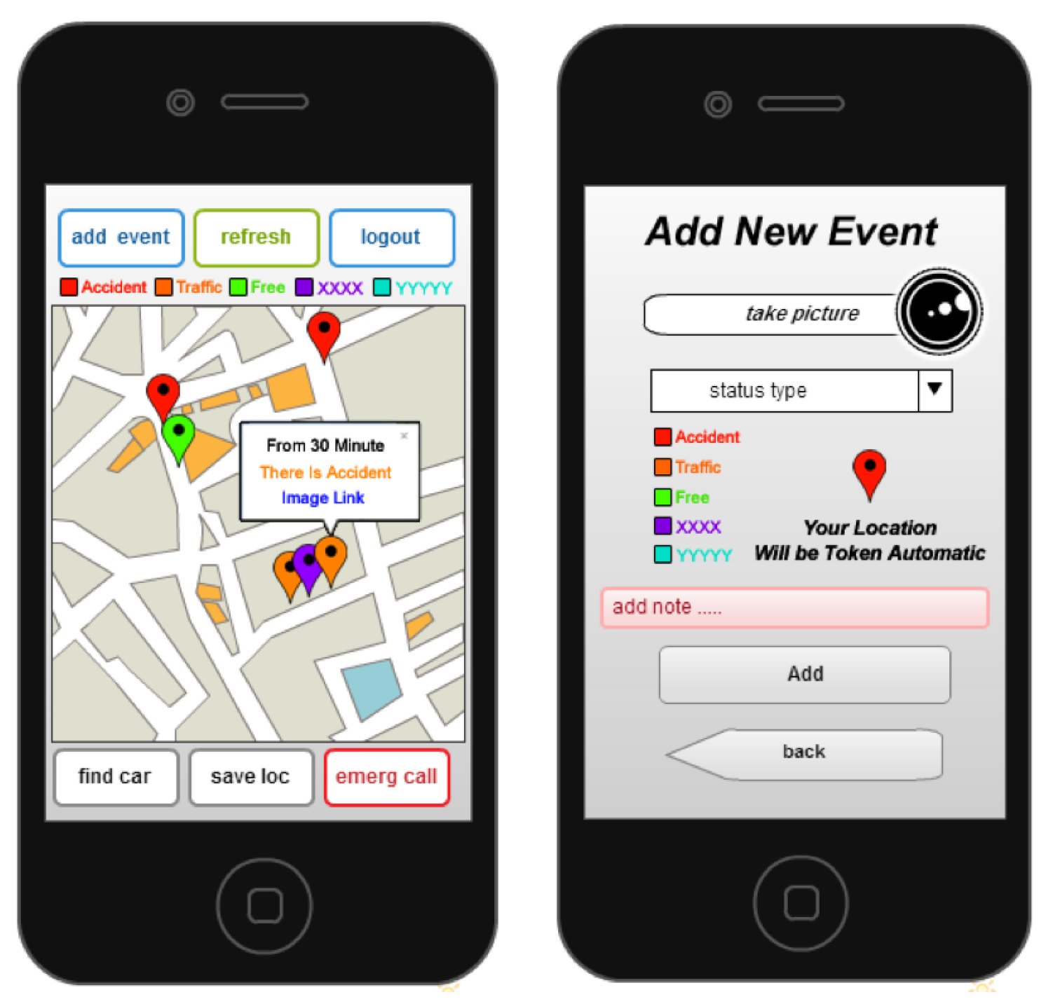
- Using crowd sourcing to exchange data between vehicles through a specific application in the event of any congestion or abnormal traffic on the street. This approach is more accurate as the incoming data are specific to the event, but it requires a high level of awareness from commuters in their use of the service. In future, this service can be automated within smart vehicles. In our implementation of the framework, we built an application for this service that works on smartphones, and contributes to the dissemination of this information to allow others to confirm the news.
- Drones distributed at central vital points can be used to capture and share images to the information center to be processed automatically. This can provide information on the size of the congestion and help in distributing the vehicular load to other streets. In our implementation of the framework, we used an image processing algorithm to calculate the severity of the congestion that has been previously published [63].
- Social media is one of the fastest ways to spread news today. In our implementation of the framework, we used Twitter. We proposed two algorithms based on text exploration and natural language processing to detect traffic congestion. The objective of first algorithm is to classify tweets related to the vehicular traffic in a particular street or area, whereas the second algorithm detects and reports the events related to congestion.
- 1.
- Collect tweets from Twitter.
- 2.
- Filter the collected tweets and extract only those that are related to the specific area.
- 3.
- Remove repeated tweets to reduce the total number of tweets.
- 4.
- Pre-process each tweet in the selected group.
- (a)
- Clean the tweets of special letters, punctuation, letters from other languages, numbers, etc., and replace them with empty spaces.
- (b)
- Encode the tweet to the list of symbols in each blank space.
- (c)
- Remove the lexemes that do not affect the result of the classification (such as articles, pronouns, etc.) using the NLTK library [64].
- (d)
- Normalize the text. This is needed when there are many similar characters with the same meaning.
- (e)
- Stammering—return the word to its original root by removing some characters (such as the prefix or suffix) using Porter’s algorithm [64].Note that the above listed steps reduce the size of the number of different words or terms by more than 60% compared to the original text.
- 5.
- Extract features and classify the tweets.
- (a)
- One approach that can be used is based on machine learning to extract the features of each tweet by calculating the TF-IDF factor for each term. IDF refers to the number of tweets containing the term T divided by the total number of tweets. The algorithm uses IDF*TF, where TF is calculated as shown in Equation (1)and IDF is calculated as shown in Equation (2)
- (b)
- The second approach is based on the DMOZ dictionary [65]. This dictionary is used to calculate the number of words related to the vehicular traffic and if they are larger than a threshold value, the tweet is classified in that category.
- (c)
- The third approach is to find the POS for each term in the tweet. We can then measure the similarity with the root of a term for vehicular traffic and its branches in a WORDNET Tree in NLTK [64]. If the result is more than the minimum, the tweet is classified in that category.
- (d)
- Finally, an ontology of important words can be built based on previous traffic data so that the most important words that symbolize vehicular traffic are identified.
- Listing 2.
- Proposed algorithm for the classification of tweets.

- 1.
- Create a list of terms that symbolize a congestion or disruption of traffic flow in any street or area, such as an accident, police checkpoint, traffic stop, congestion, fire, heavy rain, repair work, and so on.
- 2.
- Check if the number of tweets containing one of the above listed terms is more than the minimum, which means that there is such an event in that area or street. Commuters in other areas driving to the event-area will be notified to avoid heading towards it, which will reduce the size of the problem, prevent it from getting worse, and speed up the process of resolving it.
- Listing 3.
- Proposed algorithm for identifying tweets pertaining to a traffic disruption.

4.3. Level 3—Analysis of Historical Data
- 1.
- Applying machine learning algorithms to classify and aggregate data on congestion based on different criteria such as days, regions, and congestion level, as well as the cause of congestion. This enables the decision maker to develop correct strategies to avoid or resolve these issues.
- 2.
- Apply machine learning algorithms to classify and predict the percentage of congestion in a specific area at a specific time in the future and work in advance to avoid it.
4.3.1. First Step—Data Collection
4.3.2. Second Step—Data Processing and Cleaning
4.3.3. Third Step—Feature Selection
4.3.4. Fourth Step—Algorithm Selection
4.3.5. Fifth Step—Evaluation
4.3.6. Sixth Step—Visualization
4.4. Level 4—Support Services
- A parking reservation application that provides a pre-booking car-parking service and allows inquiries about the status of a parking space.
- A driver awareness application that helps commuters to enhance their awareness about the traffic rules and the status of the streets.
- An LBS-based application for searching points of interest.
- An application that supports public transportation for schools, organizations, and government institutions to solve the problem of congestion.
- An application that exploits smart signals to enables medical emergency vehicles such as ambulances to arrive their destination without any delays due to traffic congestion.
- An application that exploits sensors to measure pollution and noise levels in cities to provide smarter services.
4.5. Technologies Used at Each Level
4.5.1. First Level—Intersections
- A control camera (model number FoMaKo NDI PTZ Cameras): It captures an image of each side of the intersection periodically (every 10 s) and sends the image to the fog node to calculate the number of vehicles, shown as object 1 in Figure 4.
- WSNs are distributed on both sides of the road to calculate the number of cars passing. These sensors sense the presence of new cars once they pass through them and immediately send this information to the fog node shown as object 2 in Figure 4.
- Smart vehicles with embedded RFID tags are identified by RFID readers placed in the smart traffic lights, shown as object 3 in Figure 4.
4.5.2. Second Level—Main Streets
- The proposed algorithm for analyzing tweets, shown as object 5 in Figure 4.
- APIs of service providers such as Google Maps or OpenStreetMap that return information about the traffic state of a specific location, shown as object 6 in Figure 4.
- A mobile application developed to enable users to collaborate by sending and confirming warnings about the traffic state on streets, shown as object 7 in Figure 4.
4.5.3. Third Level—Cloud Level
4.5.4. Fourth Level—Applications and Support Services
- A Smart Parking App to reserve parking in advance to avoid the search for stopping places, which otherwise results in congestion.
- The use of public transportation for school students or employees, instead of private cars, to avoid congestion at peak times. In addition, modifying the attendance times of workplaces and schools can contribute to reduce congestion.
5. Experiment and Results
5.1. Evaluation of Level 1
- The total evaluation time was 1 h (3600 s).
- The number of streets at the intersection was 4.
- The inter-arrival time for vehicles on the first street ranged between 1 and 20 s per vehicle. This implies that the traffic congestion on the road decreases with the increase in this value.
- The inter-arrival time for vehicles on the second, third, and fourth streets was fixed at 30 s per vehicle. This implies that these streets were not congested.
- The time to get ready for an orange light was 2 s.
- -
- The maximum waiting time for any signal was 200 s.
- -
- The maximum opening time was 60 s (Green light).
- -
- The minimum opening time on the green light was 5 s (in case all cars had passed).
- The street without vehicles did not open at all.
5.1.1. Number of Serviced Vehicles
5.1.2. Average Waiting Time
5.2. Evaluation of Level-2
5.2.1. Accuracy of Tweet Classification
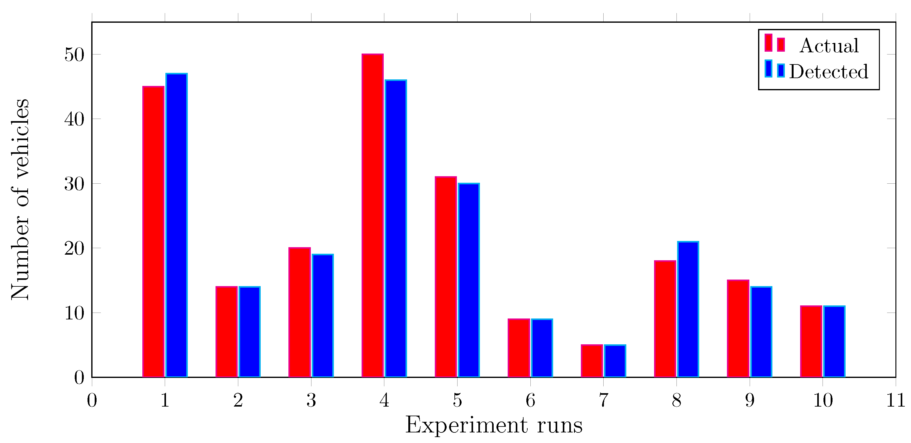
5.2.2. Accuracy of Images Processed
5.3. Evaluation of Level-3
5.4. Validation of Level-4
6. Conclusions
Author Contributions
Funding
Conflicts of Interest
References
- Isa, M.N.; Siyan, P. Analyzing factors responsible for road traffic accidents along Kano-Kaduna-Abuja Dual Carriageway Nigeria. J. Econ. Sustain. Dev. 2016, 7, 156–163. [Google Scholar]
- Zadobrischi, E.; Cosovanu, L.M.; Dimian, M. Traffic Flow Density Model and Dynamic Traffic Congestion Model Simulation Based on Practice Case with Vehicle Network and System Traffic Intelligent Communication. Symmetry 2020, 12, 1172. [Google Scholar] [CrossRef]
- Forestiero, A.; Papuzzo, G. Agents-based algorithm for a distributed information system in Internet of Things. IEEE Internet Things J. 2021, 8, 16548–16558. [Google Scholar] [CrossRef]
- Greengard, S. The Internet of Things; MIT Press: Cambridge, MA, USA, 2021. [Google Scholar]
- Bhat, W.A. Is a data-capacity gap inevitable in big data storage? Computer 2018, 51, 54–62. [Google Scholar] [CrossRef]
- Bhat, W.A. Bridging data-capacity gap in big data storage. Future Gener. Comput. Syst. 2018, 87, 538–548. [Google Scholar] [CrossRef]
- Alshekhly, I.F. Smart Cities: Survey. J. Adv. Comput. Sci. Technol. Res. 2012, 2, 79–90. [Google Scholar]
- Misbahuddin, S.; Zubairi, J.A.; Saggaf, A.; Basuni, J.; Sulaiman, A.; Al-Sofi, A. IoT based dynamic road traffic management for smart cities. In Proceedings of the 2015 12th International Conference on High-Capacity Optical Networks and Enabling/Emerging Technologies (HONET), Islamabad, Pakistan, 21–23 December 2015; IEEE: Piscataway, NJ, USA, 2015; pp. 1–5. [Google Scholar]
- Gul, F.; Mir, I.; Abualigah, L.; Sumari, P.; Forestiero, A. A Consolidated Review of Path Planning and Optimization Techniques: Technical Perspectives and Future Directions. Electronics 2021, 10, 2250. [Google Scholar] [CrossRef]
- Jebamalar, J.P.A.; Paul, S.; Latha, D.P.P. Classifying Road Traffic Data Using Data Mining Classification Algorithms: A Comparative Study. In Advances in Big Data and Cloud Computing; Springer: Berlin/Heidelberg, Germany, 2019; pp. 197–205. [Google Scholar]
- Zambrano-Martinez, J.L.; Calafate, C.T.; Soler, D.; Lemus-Zúñiga, L.G.; Cano, J.C.; Manzoni, P.; Gayraud, T. A centralized route-management solution for autonomous vehicles in urban areas. Electronics 2019, 8, 722. [Google Scholar] [CrossRef] [Green Version]
- Nafi, N.S.; Khan, R.H.; Khan, J.Y.; Gregory, M. A predictive road traffic management system based on vehicular ad-hoc network. In Proceedings of the 2014 Australasian Telecommunication Networks and Applications Conference (ATNAC), Southbank, VIC, Australia, 26–28 November 2014; IEEE: Piscataway, NJ, USA, 2014; pp. 135–140. [Google Scholar]
- Costa, L.R.; Rauen, M.S.; Fronza, A.B. Car speed estimation based on image scale factor. Forensic Sci. Int. 2020, 310, 110229. [Google Scholar] [CrossRef]
- Hlehel, F.; Mansour, I.; Abu Saan, A. Video Based Car Speed Measurements and Detection. 2017. Available online: https://repository.najah.edu/handle/20.500.11888/13148 (accessed on 1 February 2022).
- Aloul, F.; Zualkernan, I.; Abu-Salma, R.; Al-Ali, H.; Al-Merri, M. iBump: Smartphone application to detect car accidents. Comput. Electr. Eng. 2015, 43, 66–75. [Google Scholar] [CrossRef]
- Amin, M.S.; Jalil, J.; Reaz, M.B.I. Accident detection and reporting system using GPS, GPRS and GSM technology. In Proceedings of the 2012 International Conference on Informatics, Electronics & Vision (ICIEV), Dhaka, Bangladesh, 18–19 May 2012; IEEE: Piscataway, NJ, USA, 2012; pp. 640–643. [Google Scholar]
- Fanca, A.; Puscasiu, A.; Folea, S.; Vălean, H. Trauma accident detecting and reporting system. In Proceedings of the 2018 IEEE International Conference on Automation, Quality and Testing, Robotics (AQTR), Cluj-Napoca, Romania, 24–26 May 2018; IEEE: Piscataway, NJ, USA, 2018; pp. 1–5. [Google Scholar]
- Qu, L.; Li, W.; Li, W.; Ma, D.; Wang, Y. Daily long-term traffic flow forecasting based on a deep neural network. Expert Syst. Appl. 2019, 121, 304–312. [Google Scholar] [CrossRef]
- Basavaraju, A.; Doddigarla, S.; Naidu, N.; Malgatti, S. Vehicle density sensor system to manage traffic. IJRET Int. J. Res. Eng. Technol. 2014, 3, 566–569. [Google Scholar]
- Arifin, M.S.; Razi, S.A.; Haque, A.; Mohammad, N. A Microcontroller Based Intelligent Traffic Control System. Am. J. Embed. Syst. Appl. 2019, 7, 21–25. [Google Scholar]
- Guerrero-Ibáñez, J.; Zeadally, S.; Contreras-Castillo, J. Sensor technologies for intelligent transportation systems. Sensors 2018, 18, 1212. [Google Scholar] [CrossRef] [Green Version]
- Lam, A.Y.; Leung, Y.W.; Chu, X. Autonomous-vehicle public transportation system: Scheduling and admission control. IEEE Trans. Intell. Transp. Syst. 2016, 17, 1210–1226. [Google Scholar] [CrossRef] [Green Version]
- Tokody, D.; Mezei, I.J.; Schuster, G. An overview of autonomous intelligent vehicle systems. In Vehicle and Automotive Engineering; Springer: Cham, Switzerland, 2017; pp. 287–307. [Google Scholar]
- Ghazal, B.; ElKhatib, K.; Chahine, K.; Kherfan, M. Smart traffic light control system. In Proceedings of the 2016 Third International Conference on Electrical, Electronics, Computer Engineering and Their Applications (EECEA), Beirut, Lebanon, 21–23 April 2016; IEEE: Piscataway, NJ, USA, 2016; pp. 140–145. [Google Scholar]
- Jagadeesh, Y.; Suba, G.M.; Karthik, S.; Yokesh, K. Smart autonomous traffic light switching by traffic density measurement through sensors. In Proceedings of the 2015 International Conference on Computers, Communications, and Systems (ICCCS), Kanyakumari, India, 2–3 November 2015; IEEE: Piscataway, NJ, USA, 2015; pp. 123–126. [Google Scholar]
- Möller, D.P.; Fidencio, A.X.; Cota, E.; Jehle, I.A.; Vakilzadian, H. Cyber-physical smart traffic light system. In Proceedings of the 2015 IEEE International Conference on Electro/Information Technology (EIT), Dekalb, IL, USA, 21–23 May 2015; IEEE: Piscataway, NJ, USA, 2015; pp. 546–551. [Google Scholar]
- Toh, C.K.; Cano, J.C.; Fernandez-Laguia, C.; Manzoni, P.; Calafate, C.T. Wireless digital traffic signs of the future. IET Netw. 2019, 8, 74–78. [Google Scholar] [CrossRef]
- Toh, C.K. Future application scenarios for MANET-based intelligent transportation systems. In Proceedings of the Future Generation Communication and Networking (FGCN 2007), Jeju, Korea, 6–8 December 2007; IEEE: Piscataway, NJ, USA, 2007; Volume 2, pp. 414–417. [Google Scholar]
- Englund, C.; Chen, L.; Vinel, A.; Lin, S.Y. Future applications of VANETs. In Vehicular ad hoc Networks; Springer: Berlin/Heidelberg, Germany, 2015; pp. 525–544. [Google Scholar]
- Wang, L.; Chen, F.; Yin, H. Detecting and tracking vehicles in traffic by unmanned aerial vehicles. Autom. Constr. 2016, 72, 294–308. [Google Scholar] [CrossRef]
- Schirokoff, A.; Pilli-Sihvola, E.; Sihvola, N. Assessing the safety impacts of intersection safety systems. Procedia-Soc. Behav. Sci. 2012, 48, 1515–1524. [Google Scholar] [CrossRef] [Green Version]
- Chikaka, T.P.; Longe, O.M. An Automatic Vehicle Accident Detection and Rescue System. In Proceedings of the 2021 IEEE 6th International Forum on Research and Technology for Society and Industry (RTSI), Naples, Italy, 6–9 September 2021; IEEE: Piscataway, NJ, USA, 2021; pp. 418–423. [Google Scholar]
- Megalingam, R.K.; Nair, R.N.; Prakhya, S.M. Wireless vehicular accident detection and reporting system. In Proceedings of the 2010 International Conference on Mechanical and Electrical Technology, Singapore, 10–12 September 2010; IEEE: Piscataway, NJ, USA, 2010; pp. 636–640. [Google Scholar]
- Ahire, H.S.; Kamble, M.B.; Khade, P.K.; Ghare, R.A.; Jadhav, B. Vehicle accident detection and alerting system. Int. J. Res. Sci. Eng. Technol. 2018, 6, 67. [Google Scholar] [CrossRef]
- Parmar, P.; Sapkal, A.M. Real time detection and reporting of vehicle collision. In Proceedings of the 2017 International Conference on Trends in Electronics and Informatics (ICEI), Tirunelveli, India, 11–12 May 2017; IEEE: Piscataway, NJ, USA, 2017; pp. 1029–1034. [Google Scholar]
- Nath, I.; Dey, A.; Das, S.; Battavyal, R.; Ballav Garai, B.; Majumder, A. A New Accident Alert System Using Android App Development. In Proceedings of the 2nd International Conference on Non-Conventional Energy: Nanotechnology & Nanomaterials for Energy & Environment (ICNNEE), Kolyani, India, 18–19 October 2019. [Google Scholar]
- Parekh, S.; Dhami, N.; Patel, S.; Undavia, J. Traffic signal automation through IoT by sensing and detecting traffic intensity through IR sensors. In Information and Communication Technology for Intelligent Systems; Springer: Berlin/Heidelberg, Germany, 2019; pp. 53–65. [Google Scholar]
- Muthuramalingam, S.; Bharathi, A.; Gayathri, N.; Sathiyaraj, R.; Balamurugan, B. IoT based intelligent transportation system (IoT-ITS) for global perspective: A case study. In Internet of Things and Big Data Analytics for Smart Generation; Springer: Berlin/Heidelberg, Germany, 2019; pp. 279–300. [Google Scholar]
- Ang, L.M.; Seng, K.P.; Ijemaru, G.K.; Zungeru, A.M. Deployment of IoV for smart cities: Applications, architecture, and challenges. IEEE Access 2018, 7, 6473–6492. [Google Scholar] [CrossRef]
- Hussain, M.M.; Khan, F.; Alam, M.S.; Beg, M.S. Fog computing for ubiquitous transportation applications—A smart parking case study. In Engineering Vibration, Communication and Information Processing; Springer: Berlin/Heidelberg, Germany, 2019; pp. 241–252. [Google Scholar]
- Mostafa, M.H. Internet of Things-Based Framework for Public Transportation Fleet Management in Non-smart City. In Proceedings of the Emerging Technologies for Developing Countries: Second EAI International Conference, AFRICATEK 2018, Cotonou, Benin, 29–30 May 2018; Springer: Berlin/Heidelberg, Germany, 2018; Volume 260, p. 3. [Google Scholar]
- Ma, L.; Huo, Y.; Hu, C.; Li, W. Security and Privacy for Smart Cyber-Physical Systems. Secur. Commun. Netw. 2019, 2019, 7045862. [Google Scholar] [CrossRef]
- Abi Sen, A.A.; Eassa, F.A.; Jambi, K. Preserving privacy of smart cities based on the fog computing. In Proceedings of the International Conference on Smart Cities, Infrastructure, Technologies and Applications, Jeddah, Saudi Arabia, 27–29 November 2017; Springer: Berlin/Heidelberg, Germany, 2017; pp. 185–191. [Google Scholar]
- Forestiero, A. Metaheuristic algorithm for anomaly detection in Internet of Things leveraging on a neural-driven multiagent system. Knowl.-Based Syst. 2021, 228, 107241. [Google Scholar] [CrossRef]
- Shin, K.G.; Ju, X.; Chen, Z.; Hu, X. Privacy protection for users of location-based services. IEEE Wirel. Commun. 2012, 19, 30–39. [Google Scholar] [CrossRef]
- Wernke, M.; Skvortsov, P.; Dürr, F.; Rothermel, K. A classification of location privacy attacks and approaches. Pers. Ubiquitous Comput. 2014, 18, 163–175. [Google Scholar] [CrossRef]
- Abi Sen, A.A.; Eassa, F.A.; Jambi, K.; Yamin, M. Preserving privacy in internet of things: A survey. Int. J. Inf. Technol. 2018, 10, 189–200. [Google Scholar] [CrossRef]
- Lin, J.; Yu, W.; Zhang, N.; Yang, X.; Zhang, H.; Zhao, W. A survey on internet of things: Architecture, enabling technologies, security and privacy, and applications. IEEE Internet Things J. 2017, 4, 1125–1142. [Google Scholar] [CrossRef]
- Atzori, L.; Iera, A.; Morabito, G. The internet of things: A survey. Comput. Netw. 2010, 54, 2787–2805. [Google Scholar] [CrossRef]
- Rathore, M.M.; Paul, A.; Hong, W.H.; Seo, H.; Awan, I.; Saeed, S. Exploiting IoT and big data analytics: Defining smart digital city using real-time urban data. Sustain. Cities Soc. 2018, 40, 600–610. [Google Scholar] [CrossRef]
- Babar, M.; Arif, F.; Jan, M.A.; Tan, Z.; Khan, F. Urban data management system: Towards Big Data analytics for Internet of Things based smart urban environment using customized Hadoop. Future Gener. Comput. Syst. 2019, 96, 398–409. [Google Scholar] [CrossRef]
- Darwish, T.S.; Bakar, K.A. Fog based intelligent transportation big data analytics in the internet of vehicles environment: Motivations, architecture, challenges, and critical issues. IEEE Access 2018, 6, 15679–15701. [Google Scholar] [CrossRef]
- Hussain, M.; Alam, M.S.; Beg, M. Fog computing in IoT aided smart grid transition-requirements, prospects, status quos and challenges. arXiv 2018, arXiv:1802.01818. [Google Scholar]
- Toh, C.K.; Sanguesa, J.A.; Cano, J.C.; Martinez, F.J. Advances in smart roads for future smart cities. Proc. R. Soc. A 2020, 476, 20190439. [Google Scholar] [CrossRef] [PubMed]
- Boffey, D. World’s first electrified road for charging vehicles opens in Sweden. The Guardian, 13 April 2018. [Google Scholar]
- Zhou, M.; Huang, D.; Hu, Y.; Zhou, L.; An, L. Musical roads: Design, construction and potential economic and safety benefits. In Proceedings of the Institution of Civil Engineers-Transport; Thomas Telford Ltd.: London, UK, 2018; pp. 1–27. [Google Scholar] [CrossRef]
- IEC, I. Smart Cities Preliminary Report; ISO/IEC JTC1: Geneva, Switzerland, 2014. [Google Scholar]
- Martinez, F.J.; Toh, C.K.; Cano, J.C.; Calafate, C.T.; Manzoni, P. Emergency services in future intelligent transportation systems based on vehicular communication networks. IEEE Intell. Transp. Syst. Mag. 2010, 2, 6–20. [Google Scholar] [CrossRef]
- Umedu, T.; Isu, K.; Higashino, T.; Toh, C.K. An intervehicular-communication protocol for distributed detection of dangerous vehicles. IEEE Trans. Veh. Technol. 2009, 59, 627–637. [Google Scholar] [CrossRef]
- Jacob, B.; Feypell-de La Beaumelle, V. Improving truck safety: Potential of weigh-in-motion technology. IATSS Res. 2010, 34, 9–15. [Google Scholar] [CrossRef] [Green Version]
- Winter, K.; Campbell, B. Technology Helps Us Do Things Better: Virtual Weigh Stations, Other New Methods for Enforcing the Law Prolong Highway Life and Increase Vehicle Citations; Virginia Department of Transportation: Richmond, VA, USA, 2009. [Google Scholar]
- Jacob, B.; OBrien, E.; Jehaes, S. Weigh-in-Motion of Road Vehicles: Final Report of the COST 323 Action; LCPC: Paris, France, 2002. [Google Scholar]
- Abi Sen, A.A.; Alsaawy, Y.; Alkhodre, A.; Bahbouh, N.M.; Alhaboob, M. Smart Street Design for Managing Crowds in Hajj. In Proceedings of the 2021 8th International Conference on Computing for Sustainable Global Development (INDIACom), New Delhi, India, 17–19 March 2021; IEEE: Piscataway, NJ, USA, 2021; pp. 385–389. [Google Scholar]
- Roul, R.K.; Gugnani, S.; Kalpeshbhai, S.M. Clustering based feature selection using extreme learning machines for text classification. In Proceedings of the 2015 Annual IEEE India Conference (INDICON), New Delhi, India, 17–20 December 2015; IEEE: Piscataway, NJ, USA, 2015; pp. 1–6. [Google Scholar]
- Alharbi, A.; Halikias, G.; Sen, A.A.A.; Yamin, M. A framework for dynamic smart traffic light management system. Int. J. Inf. Technol. 2021, 13, 1769–1776. [Google Scholar] [CrossRef]
- Bokaba, T.; Doorsamy, W.; Paul, B.S. Comparative study of machine learning classifiers for modelling road traffic accidents. Appl. Sci. 2022, 12, 828. [Google Scholar] [CrossRef]
- Elsagheer Mohamed, S.A.; AlShalfan, K.A. Intelligent Traffic Management System Based on the Internet of Vehicles (IoV). J. Adv. Transp. 2021, 2021, 4037533. [Google Scholar] [CrossRef]


| Literature | Central Idea of the Work(s) |
|---|---|
| [7,8] | Highlight many issues related to smart cities in which the need for smart-transportation has been emphasized |
| [10] | Use of data mining for classifying roads into six categories according to density |
| [13] | Estimates the speed of a car from a video based on the image scale factor |
| [14] | Methods for addressing traffic congestion using image processing |
| [15] | Techniques based on image processing and deep leaning for remote sensing images |
| [16] | Overview of image processing algorithms and traffic issues |
| [17] | Applications of AI in transport systems |
| [18] | Deep learning to manage traffic flow |
| [19] | WSN and RFID on roads to create smart/dynamic traffic light |
| [20] | Real-time intelligent central control unit can deal with traffic emergencies |
| [21] | Application of sensors and RFID in smart traffic management |
| [22] | Uses scheduling algorithms to select the optimal path for an autonomous vehicle (AV) |
| [23] | An overview of AV is presented |
| [24] | Use micro-controllers and IR sensors to detect traffic density and control the traffic signal |
| [25] | A signal control project based on radio sensors with an Arduino low-power micro-controller |
| [26] | Estimating the time of vehicles arriving at traffic lights |
| [27,28,29,30] | Use modern technologies such as wireless devices, and drones to overcome limitations of surveillance cameras and radars |
| [31] | Employed a set of radio sensors to monitor blocked and moving vehicles |
| [32] | Use an accelerometer and GPS sensors to monitor the security and safety of commuters, and share the accident information with their relatives |
| [33] | Use a micro-controller and sensors for detecting accidents |
| [34,35,36] | Designed an accident control system that sends a text message after recognizing the accident |
| [37] | Monitoring and managing traffic using IoT |
| [38] | Argues that IoT connects physical things to the internet in order to build smart systems such as ITSs |
| [39] | Proposes using vehicles as sensing points to bring more services, safety, and efficiency for transport system |
| [40] | Integrating an intelligent transportation system (ITS) with IoT can achieve the goal of smart transportation |
| [41] | Found an increase in LBS applications, especially in smart cities with the IoT |
| [42] | Highlighted that a new level of security and privacy is required in the merging of IoT and smart transportation to protect users’ data |
| [43,45] | Highlighted that preserving privacy is a vital issue in the smart systems |
| [46,47] | Surveys on methods and techniques for preserving privacy in smart transportation |
| [48,49] | A complete overview of IoT and its structure, layers, phases, applications, and future trends |
| [50] | Using big data to address the issue of traffic congestion |
| [51] | Discusses the challenges and drivers of using machine learning algorithms with big data in the transportation field |
| [52] | Uses fog computing to address smart transportation challenges |
| [53] | Discusses the challenges of using fog computing in ITS and highlights its contribution. |
| [54] | Harvesting energy generated on roads by vehicles for powering street and traffic lights |
| [55] | Automatically charging electric vehicles using energy generated by vehicles on roads |
| [56] | Makes use of musical songs generated by roads to warn commuters about the safety of their vehicle |
| [57,58,59] | Exchanges critical information such as accident information between vehicles, and between vehicles and devices installed in the streets |
| [60,61,62] | Develop techniques that enable the measurement of the weights of static or mobile vehicles |
Publisher’s Note: MDPI stays neutral with regard to jurisdictional claims in published maps and institutional affiliations. |
© 2022 by the authors. Licensee MDPI, Basel, Switzerland. This article is an open access article distributed under the terms and conditions of the Creative Commons Attribution (CC BY) license (https://creativecommons.org/licenses/by/4.0/).
Share and Cite
Alsaawy, Y.; Alkhodre, A.; Abi Sen, A.; Alshanqiti, A.; Bhat, W.A.; Bahbouh, N.M. A Comprehensive and Effective Framework for Traffic Congestion Problem Based on the Integration of IoT and Data Analytics. Appl. Sci. 2022, 12, 2043. https://0-doi-org.brum.beds.ac.uk/10.3390/app12042043
Alsaawy Y, Alkhodre A, Abi Sen A, Alshanqiti A, Bhat WA, Bahbouh NM. A Comprehensive and Effective Framework for Traffic Congestion Problem Based on the Integration of IoT and Data Analytics. Applied Sciences. 2022; 12(4):2043. https://0-doi-org.brum.beds.ac.uk/10.3390/app12042043
Chicago/Turabian StyleAlsaawy, Yazed, Ahmad Alkhodre, Adnan Abi Sen, Abdullah Alshanqiti, Wasim Ahmad Bhat, and Nour Mahmoud Bahbouh. 2022. "A Comprehensive and Effective Framework for Traffic Congestion Problem Based on the Integration of IoT and Data Analytics" Applied Sciences 12, no. 4: 2043. https://0-doi-org.brum.beds.ac.uk/10.3390/app12042043