Article

Islands in the Caucasian Sea in Three Mesozoic Time Slices: Novel Dimension of Geoheritage and Geotourism

by
Dmitry A. Ruban
1,2
1
Department of Organization and Technologies of Service Activities, Higher School of Business, Southern Federal University, 23-ja Linija Street 43, 344019 Rostov-on-Don, Russia
2
K.G. Razumovsky Moscow State University of Technologies and Management (the First Cossack University), Zemlyanoy Val Street 73, 109004 Moscow, Russia
J. Mar. Sci. Eng. 2022, 10(9), 1300; https://0-doi-org.brum.beds.ac.uk/10.3390/jmse10091300
Submission received: 12 August 2022 / Revised: 11 September 2022 / Accepted: 13 September 2022 / Published: 15 September 2022
(This article belongs to the Special Issue Recent Advances in Geological Oceanography)

Abstract

:
Framing geoheritage thematically is important to reveal its diversity. Field investigations in the western part of the Greater Caucasus orogen have allowed for the characterization of three localities representing palaeoislands of the Caucasian Sea, which evolved as a semi-enclosed, marginal palaeosea during the Mesozoic. The Gosh locality represents coarse siliciclastics formed on the cliffed shore of the early Induan (Early Triassic) island. The Lipovy locality exhibits conglomerates accumulated on the shore of the early Toarcian (Early Jurassic) island due to erosion of the uplifted crystalline rocks. The Shakhan locality boasts a representative section of cross-bedded sandstones deposited on the alluvial plain of the Hauterivian (Early Cretaceous) island. All these localities are interpreted as geoheritage points, which are parts of larger geosites. Taken together, these points constitute thematic geoheritage sites reflecting the existence of palaeoislands in all Mesozoic periods, which is essential for the understanding of the evolution of the Caucasian Sea during this era. These localities are perfectly accessible, but visiting them requires professional interpretation. The importance of the thematic geoheritage makes its adequate management urgent (particularly, maintenance of geoheritage points, the installation of interpretive panels, and promotion). A geoexcursion route is proposed to facilitate geotouristic exploitation of the characterized geoheritage sites.

1. Introduction

The spectrum of unique geological phenomena is very wide, which determines a high diversity of geoheritage. On the one hand, this diversity itself strengthens the need for geoheritage conservation in general (indeed, each case also needs close attention). On the other hand, it challenges effective geoheritage management and use in tourism, which are difficult to organize properly in heterogeneous geological environments. If so, it is very reasonable to find approaches for the systematic, logical treatment of unique geological phenomena to receive true benefits from their diversity. One approach is putting geoheritage into thematic frames. Poiraud et al. [1] paid attention to five thematic spaces (glaciotectonic, palaeogeomorphological, hydrogeological, morphotectonical, and stratigraphical) of the Vercors massif in the French Alps for the better development of geoeducation and geotourism. Migoń et al. [2] thematically grouped the granite geomorphological heritage of the Waldviertel region in Lower Austria. Herrera-Franco et al. [3] analyzed thematic travel itineraries in the Santa Elena province of Ecuador.
Indeed, grouping geoheritage features along the geological time arrow [4] or the sequence of depositional environments [5] seems to be very promising for communicating local geological knowledge. Particularly, such solutions allow one to present this knowledge logically for better comprehension. The gradually developed idea of palaeogeographical geoheritage, which is understood as either a particular geoheritage type [6] or highly complex phenomena [7], helps to justify such thematic frames. Nonetheless, more examples from different geological domains are necessary to realize the full potential of this approach and the spectrum of options for its application. Particularly, rare but often spectacular legacies of palaeoislands [6,8,9,10,11] constitute a promising theme for geoheritage treatment and geotourism development.
The Caucasus is a large, geologically rich domain in the northern flank of the Cenozoic active tectonic belt stretching through Eurasia for thousands of kilometers [12,13,14,15,16,17,18,19]. Its largest, northern part, namely, the Greater Caucasus, can serve as a “natural laboratory” for studying Mesozoic sedimentary complexes, which include widely distributed Triassic, Jurassic, and Cretaceous deposits of different natures. These deposits formed chiefly in marine palaeoenvironments of the vast Caucasian Sea, the deepest part of which corresponded to the “axis” of the present-day mountain chain. The Mesozoic marine evolution of the Greater Caucasus is well-documented and characterized, particularly in the synthetic work by Yasamanov [20]. The palaeogeographical schemes in this work depict an elongated island (or chain of islands) at the southern border of the mentioned palaeosea, which existed more or less continuously through the Mesozoic; the idea of the Caucasian island(s) corresponds well with the reconstructions of the long-lived island arc along the southern periphery of the present-day Greater Caucasus [15,21,22,23,24,25]. However, too little is known about this island mass, chiefly on the basis of indirect evidence. Filling this gap in the geological knowledge is essential for the understanding of the configuration and openness of the Mesozoic Caucasian Sea, and some new information would be precious in regard to the regional geological oceanography. Moreover, geological features related to the Mesozoic islands would extend the thematic frames of geoheritage and geotourism in the Greater Caucasus. If several lines of evidence of palaeoislands are found at different geosites, the latter can be grouped for the representation of an important palaeogeographical theme, which seems to be potentially attractive to geotourists.
New field investigations in the western part of the Greater Caucasus have allowed for the documentation of geological objects, the palaeogeographical interpretation of which indicates the existence of island mass in three time slices representing all periods of the Mesozoic, namely, the Induan (Triassic), the Toarcian (Jurassic), and the Hauterivian (Cretaceous). This new knowledge is valuable not only geologically due to the scarcity of information about palaeoislands from the study area but also in regard to geoheritage management and geotourism development, which can become more definite when particular themes are established. The study area boasts rather active exploitation of its rich geoheritage resources [26], and, thus, the theme of Mesozoic palaeoislands can be demanded there. The objective of the present contribution is to characterize the newly established geoheritage related to the Mesozoic island(s) in the Caucasian Sea. A new, palaeogeography-related geoheritage and geotourism theme is proposed. Although Mountainous Adygeya has been investigated in regard to geoheritage and geotourism for many years [4,5,26], this study presents new lines of evidence and offers novel interpretations; thus, it extends the available knowledge and proposes a new vision for geoheritage management and geotourism development.

2. Geological Setting

The study area corresponds to Mountainous Adygeya, a distinctive area of the Western Caucasus (western part of the Greater Caucasus) in southwestern Russia (Figure 1a) where geoheritage resources and geotourism concentrate [26]. It stretches along the valleys of the Belaya River and its main tributaries such as the Syryf River and the Dakh River. The area is crossed by several subparallel ranges, which trend from the west to the east. The Pastbischny Range is located to the north of Kamennomostsky, the Skalisty Range is located between Kamennomostsky and Dakhovskaya, the Burelom Range is located between Dakhovskaya and Khamyshki, and the Inzhenerny Range is located between Khamyshki and Guzeripl. Where the Belaya River crosses these ranges, it forms narrow gorges and canyons. The heights of mountains are below 1500 m. Although this area is covered by dense forests and is not populated densely, there are several settlements (these also serve as important touristic centers), the biggest of which is Kamennomostsky town. The high-quality paved and unpaved roads cross the area and determine the perfect accessibility of its geoheritage (Figure 1a).
Geologically, this area represents a Late Cenozoic orogen (fold-thrust belt) formed as a result of the collision of the Eurasian and Arabian plates with the interaction of smaller microplates [12,15,16,19]. According to the latest developments, the Greater Caucasus represents a deformation zone with a certain individuality related to the Eurasian plate [27]. Apparently, this individual domain corresponds to the Paleozoic Greater Caucasus terrain [28], and, if so, it is possible that the latter remains rather active in the regional plate tectonic framework.
The stratigraphical framework of the study area was summarized, particularly, by Plyusnina et al. [4]. The oldest are Precambrian metamorphic rocks (gneisses, amphibolites, and schists). Together with Early-Middle Paleozoic serpentinites and Late Paleozoic granitoids, these are represented in several small massifs (Dakh, Sakhray, and Rufabgo), which are uplifted basement blocks. The sedimentary complexes include the Early-Middle Permian molassic sequence (up to 1000–2000 m in thickness), Triassic carbonate and siliciclastic deposits (~1700 m in thickness), Early-Middle Jurassic siliciclastic, often dark shale-dominated deposits (up to 10,000 m in thickness), Late Jurassic carbonate and evaporite deposits (~3000 m in thickness), Early Cretaceous mixed carbonate and siliciclastic deposits (up to 500 m in thickness), and Quaternary deposits (alluvial, deluvial, colluvial, and locally glacial). The Jurassic complexes are spread most widely.
The Mesozoic deposits accumulated in the tropical, elongated, semi-enclosed Caucasian Sea with rich ecosystems, which corresponded to the back-arc basin between the rather stable platform domains in the north and the active island arc in the south (Figure 1b). Although its configuration changed due to global eustatic fluctuations and regional tectonic movements (both horizontal and vertical), this palaeosea remained generally the same since at least the Jurassic period [20]. The Triassic palaeogeography remains almost unknown, although it is very likely that the general situation (marginal palaeosea setting) was the same. The Cenozoic orogeny led to closure of the marine basin and the general uplift of the area. The related deformations triggered the intense folding and faulting of the Mesozoic sedimentary complexes.

3. Materials and Methods

The materials for the present study were collected in the course of field investigations in Mountainous Adygeya in July–August 2022. A total of three localities representing terrestrial palaeoenvironments were examined, namely, Gosh, Lipovy, and Shakhan (Figure 1a). Each of them was visited, described, and photographed. Attention was paid to both the geological peculiarities and geoheritage properties (see below). The local geological setting was mapped carefully to facilitate further interpretations, which are really challenging in deformed and poorly known domains (this is especially the case for the Gosh locality, with highly complex contacts of strata of different ages). In regard to geoheritage, field investigations required (among other things) the evaluation of accessibility and the approximate time and distances for reaching these localities.
The collected materials were first interpreted in terms of stratigraphy and palaeogeography. For these purposes, both original data and the earlier published developments were used (these are indicated below, in each particular case). The geological time scale developed by the International Commission on Stratigraphy [29] and the regional palaeogeographical reconstructions by Yasamanov [20] were helpful in these interpretations. The geological analysis is usually brief, simple, and somewhat preliminary to match the purposes of the present contribution aimed at thematic geoheritage.
New field observations coupled with the results of the previous assessment of unique geological phenomena of Mountainous Adygeya [26] allow for judgments of the three studied localities in terms of geoheritage, which would facilitate subsequent geotourism-related interpretations. Two main foundations of the present study should be noted. First, direct evidence of palaeoislands seems to be rare and thus unique; the related objects can always be attributed to the palaeogeographical type of geoheritage [6,7]. Second, although the basic elements of geoheritage are geosites, the latter are often large (up to several square kilometers in size) and complex (due to the coexistence of several geoheritage types), and, thus, particular unique features can be represented in their fragments, which are known as geoheritage points [30] that have something in common with geotopes [31]. Dealing with such fragments seems to be very suitable when single-theme geoheritage is considered and geosites/geoparks are “diffused” [30,32]. Of course, the correspondence of geoheritage points to geosites should be traced.
Various approaches have been proposed for the assessment of geoheritage and geosites [33,34,35,36,37,38,39]. In Mountainous Adygeya, a comprehensive assessment of geoheritage resources has been realized recently by Ruban et al. [26]. Three geoheritage points considered in the present study are only fragments of geosites, and, thus, it is not reasonable to undertake their quantitative analysis with the noted approaches aimed at geosites. Nonetheless, they require qualitative description, which can be based on the principles specified by Ruban [38], with certain additions and minor modifications. A template for descriptions is composed (Table 1), and it is used for each considered locality. Several elements and criteria of description are related to the correspondence of geoheritage localities to geosites. Spatial correspondence (the overlap between points and geosites) and contribution to geosite uniqueness (the “weight” of a given point relative to the value of the entire geosite) should be distinguished from cohesion. The latter signifies the isolation of a given point from the rest of the geosite.

4. Results

4.1. Gosh

4.1.1. Description

The Gosh locality is named after the Gosh River, which is a left tributary of the Sakhray River belonging to the Belaya River watershed (Figure 1a). It is situated in the northeastern periphery of Novoprokhladnoe village, where Triassic deposits crop out in the valley of the Gosh River. The local geology is highly complex (Figure 2). The area is dominated by Early Jurassic shales dipping to the southwest. They overlay transgressively Early Triassic limestones dipping generally northward (in fact, the dipping direction changes from northwestern to northeastern due to the intense deformation of beds) (Figure 2). This situation is represented well in the valley of the Kamennaya River, which is a right tributary of the Gosh River. However, the detailed investigation of the valley of the Gosh River has led to the discovery of two unusual beds of coarse siliciclastics near the contact between the Triassic and the Jurassic. These beds differ strikingly from the Early Jurassic deposits and dip in the same direction as the Early Triassic limestones. Evidently, they underlay the latter, and their absence in the valley of the Kamennaya River can be explained by the non-exposure of the basal part of the Triassic sequence. The lower bed, which is ~10 m in thickness, is represented by conglomerate-breccia with poorly sorted coarse particles (pebbles and cobbles) of very different shapes (from angular to perfectly rounded) consisting of pre-Triassic igneous, metamorphic, and sedimentary rocks known locally. The upper bed, which is <3 m in thickness, consists of coarse and very coarse sandstone bearing flat pebbles and cobbles, as well as irregular particles of a larger size (megaclasts) (Figure 2).
The Triassic stratigraphy of the Western Caucasus has been developed for many decades (ages of formations were established on the basis of massive palaeontological findings, including ammonoids, brachiopods, and foraminifers), and the main outcomes of these investigations were summarized by Chaitsky et al. [42], Gaetani et al. [43], and Rostovtsev et al. [44]. According to these developments, the conglometrate-breccia and megaclast-bearing beds can be attributed to the Bambak Formation (early Induan), and the overlaying limestones can be attributed to the Yatyrgvarta Formation (Induan–Olenekian). The accumulation of coarse siliciclastics took place on ancient shores. Probably, the lower bed formed at the toe of cliffs where angular slope debris particles mixed with cobbles and pebbles rounded by wave activity. The upper bed marks cliff retreat and beach extension. Hypothetically, megaclasts were emplaced by tsunamis or severe tropical storms—analogues are known from both present and ancient sedimentary archives [45,46,47,48,49,50,51]. The accumulation of coarse siliciclastics and the subsequent shift to carbonate deposition mark the transgression of the palaeosea.
Although the Bambak Formation overlays crystalline rocks, it also bears clasts consisting of Permian rocks [42] cropped out in the neighboring areas. The latest Permian deposits are Changhsingian in age, and marine deposition continued at the Permian/Triassic boundary [52]. If so, it is possible that the relative sea-level fall, which preceded the above-mentioned transgression that started already in the early Induan, was very short-term but pronounced. It cannot be brought in correspondence to any global eustatic fall [53], and, therefore, it should be explained by local uplifts immediately after the Permian/Triassic boundary. Notably, the Bambak Formation formed only locally in Mountainous Adygeya, and marine sandstones and probably even limestones accumulated contemporaneously. Hypothetically, the palaeosea did not retreat but only changed its configuration because of the noted uplifts. If so, and taking into account the palaeogeographical position of the study area far from the “stable” craton, the ancient cliffed shore interpreted at the Gosh locality can be attributed to any palaeoisland. The latter was quickly submerged together with the Induan transgression, as implied by the wide distribution of the generally monotonous Yatyrgvarta Formation.

4.1.2. Geoheritage

The characteristics given above imply that the Gosh locality allows for interesting insights into the earliest Triassic palaeogeography of the Western Caucasus, and it is related directly to the thematic geoheritage considered in the present study. This locality is a geoheritage point of a large, earlier-established geosite, namely, the Sakhray Canyon (Figure 1a), which is famous for waterfalls and its extensive Triassic section [26]. The small locality represents the edge of this geosite. The features reported from the valley of the Gosh River contribute to the uniqueness of the entire geosite, but they do not determine its value. The dominant geoheritage type in this point is palaeogeographical, but one should also note the existence of the stratigraphical type (a section of the Bambak Formation outside of where it is reported commonly) and the sedimentary type (megaclasts). The Gosh geoheritage point occupies an isolated position relative to the rest of the geosite, although one can reach the Sakhray Canyon from there either by going down the stream or preferring an unpaved road.
The outer accessibility of this geoheritage point is excellent because an unpaved but well-maintained road leads directly to the Gosh River in Novoprokhladnoe village (Figure 3). The inner accessibility is more or less perfect: the river valley is rather wide and free of woody debris, although one should be prepared for hiking directly in streams with masses of pebbles and cobbles. In other words, some experience is required for reaching the target outcrops. Indeed, visits there can be organized in only good weather (without rain) in summer. This locality is not vulnerable to any negative factors, although the occasional accumulation of woody debris may make visiting the outcrops challenging. Indeed, expert knowledge and/or professional guidance are necessary for visiting this geoheritage point with profit, i.e., the highly complex local geology, including the stratigraphical framework and the palaeogeographical hypotheses, should be communicated. The aesthetic properties of this geoheritage point, determined by its genuine wilderness, unusual view of megaclast-bearing sandstone, and small waterfalls, recompense interpretation needs.
The scientific importance of the Gosh locality is undisputable because it allows for the undertaking of research in the Triassic palaeogeography (sensu lato) of the Greater Caucasus, which remains poorly known. Although this research seems to be only regionally important at a first glance, one should take into account the “key” position of the Greater Caucasus for revealing the palaeogeographical setting between the domains of South Europe and the Middle East. The previous investigation of an international research group [43] proves the significance of such studies. Therefore, this geoheritage point seems to be interesting to the international research audience. The educational importance is determined by the possibility to demonstrate examples of deposits of ancient shores to university students (at least three large Russian universities organize summer field practices for their students in geology and geography, and some others do this irregularly), as well as to offer them some tasks in structural geology in highly deformed sedimentary domains. The touristic importance is discussed separately (see below).

4.2. Lipovy

4.2.1. Description

The Lipovy locality is named after the Lipovy River, which is a right tributary of the Belaya River (Figure 1a). It is located near the northern entrance to the Granite canyon, where there is a sharp boundary between Mesozoic sedimentary complexes and the Precambrian–Paleozoic crystalline rocks, and both crop out in the valley of the Lipovy River. The local geology has been deciphered previously by Ruban [54], Nenakhov et al. [55], and Chepurnoy [56]. The area is dominated by the rocks of the Dakh Crystalline Massif. Although it is composed chiefly of Late Paleozoic granitoids, Precambrian metamorphics with sporadic bodies of Early–Middle Paleozoic serpentinites constitute its northern periphery (Figure 1a). Near the mouth of the Lipovy River, these rocks are overlain transgressively by horizontally lying conglomerates (Figure 4) with a thickness of ~2 m, bearing thin (5–15 cm) sandstone interbeds. The conglomerates consist of poorly sorted, chiefly rounded (but the angularity of some particles is also evident) pebbles, cobbles, and boulders representing igneous and metamorphic rocks of the Dakh Crystalline Massif [56].
The Jurassic stratigraphy of the Western Caucasus has been developed for more than a century, and the present stratigraphical framework (ages of formations were established with ammonites, brachiopods, foraminifers, and other fossils) is given in the synthetic work by Rostovtsev et al. [57]. The latter specifies the Bagovskaya Formation (early Toarcian) with basal conglomerate beds. The conglomerates from the valley of the Lipovy River were attributed to these basal beds [54]. They accumulated on the shore of a small palaeoisland, which corresponded to the Dakh Crystalline Massif uplifted during the Late Triassic–Early Jurassic phase of tectonic activity [6,54]. This palaeoisland submerged together with the development of the Toarcian transgression and the related quick growth of the Caucasian Sea. These interpretations generally match the reconstructions undertaken by Panov et al. [58], who described the Early Jurassic evolution of the Western Caucasus and adjacent areas as a time of multiple graben development and related palaeogeographical reorganizations, as a result of which palaeoislands appeared and disappeared.

4.2.2. Geoheritage

The Lipovy locality, which is the best studied among the other considered localities, offers important information for the understanding of the Early Jurassic palaeogeography of the Western Caucasus when the Caucasian Sea evolved (Figure 1b). It is directly related to the thematic geoheritage considered in the present study. This is a geoheritage point of a larger, linear geosite, namely, the Granite Gorge. The latter was characterized comprehensively by Karpunin et al. [59], Mikhailenko et al. [60], and Ruban et al. [26], and it is famous for lengthy exposures of granitoids, metamorphic formations, and a deep river incision. The Lipovy geoheritage point is very small in size and marks the very northern edge of this geosite. Although the former is very important, its geoheritage value is incomparably less than that of the entire geosite. The Early Jurassic conglomerate beds overlay metamorphic rocks in the same outcrop where their most representative section is available. Some interesting and very rare mineral assemblage and highly specific rodingite rock are also found there. As a result, this locality represents, at least, four geoheritage types (palaeogeographical, metamorphic, mineralogical, and igneous—see Mikhailenko et al. [60] for more details), which indicates its significant complexity. The cohesion of the Lipovy geoheritage point to the Granite Gorge geosite is moderate. On the one hand, the conglomerate outcrop is linked physically to the neighboring outcrops of metamorphic rocks available in the Lipovy River valley and close to it along the road. On the other hand, the group of outcrops near the northern entrance to the gorge demonstrates individual features, and this group can be differentiated from the main chain of outcrops representing granitoids.
The outer accessibility of the geoheritage point is excellent because it is located close to the principal, paved, and well-maintained road. The inner accessibility is limited by the necessity to travel several dozens of meters along the Lipovy River, the valley of which has steep slopes and a lot of large clasts on the bottom (Figure 5). Moreover, one needs to climb several meters to reach the upper part of the slope where the conglomerates are exposed. Principally, this challenge can be addressed via creating a temporary trail with stairs, which would require no more than 1–2 h of work. The geoheritage point can be visited during the entire year, except for winter and spring days with bad weather conditions or high water levels. The dense tree cover protects visitors from heavy rain. A true problem is that the accommodation space in the locality and, thus, its carrying capacity are too limited; no more than three persons can stay near the conglomerates and no more than fifteen persons can stay at the slope’s toe. The Lipovy locality is vulnerable to two negative factors. First, the maintenance of the road can lead to the slope cutting in the near future, which will either damage or even destroy the outcrop. Second, the valley of the Lipovy River is prone to landslides and rockfalls. One of them occurred a few years ago and already damaged the conglomerate outcrop (a part of it was detached and slid down). The geoheritage point can be clear to both experts and non-experts with elementary geological knowledge because conglomerates and their contact with the underlying crystalline rocks are easy-to-realize. However, professional guidance is required to learn about the age and the palaeogeographical interpretations. The locality does not boast any significant aesthetic properties, and it is permanently shadowed by tree cover (Figure 5).
The Lipovy geoheritage point has already been investigated intensively [54,55,56]. Indeed, some additional material for subsequent, international-level research can be gathered there. The educational importance of the locality is significant because it is an ideal site to learn about basal conglomerates. However, it is diminished by the limited carrying capacity. The touristic importance is discussed separately (see below).

4.3. Shakhan

4.3.1. Description

The Shakhan locality is named after the Shakhan Mountain, which is situated to the north of Kamennomostsky town and borders the valley of the Belaya River from the east (Figure 1a). The area is dominated by the Late Jurassic and Early Cretaceous deposits (Figure 6). The former are represented by variegated, often red siliciclastics, whereas the latter consist of carbonate (limestones) and siliciclastic (shales and sandstones) rocks, which often form mixed packages. Near the top of the Shakhan Mountain, on its southwestern slope, an abandoned sandstone quarry is located. There, a thick succession (up to 30 m) of yellowish-white, cross-bedded sandstones is represented. These rocks consist of coarse and very coarse sand particles, and they also include rare rounded gravels. Some layers exhibit brown patterns due to iron enrichment. Coalified plant remains (particularly, stem fragments) are rather numerous.
The Cretaceous stratigraphy of the Western Caucasus has been developed for a long time, although some questions remain unresolved. The available stratigraphical frameworks justified by biostratigraphical developments (with ammonites and foraminifers) were characterized, particularly, by Drushits and Mikhailova [61], Prosorovskaya [62], and Mikerina and Pinchuk [63]. They assign the cross-bedded sandstones from the Shakhan locality to the Gubs Formation. The age of the latter is defined provisionally as Hauterivian. The sandstones formed, most probably, on the alluvial plain. However, the latter was close to the seashore because the Gubs Formation includes typically marine facies and fossils in the neighboring areas [62].
Taking into account the palaeogeographical setting of the Western Caucasus depicted by Yasamanov [20], it is evident that the Caucasian Sea separated the study area from the “northern” land masses, i.e., its general configuration (Figure 1b) remained in the Hauterivian. If so, the alluvial plain where the cross-bedded sandstones accumulated can be attributed to any large palaeoisland along the southern periphery of the palaeosea [20]. The sandstones dip to the northeast, although cross-bedding demonstrates almost northward dipping (Figure 4). This means that the initial (before tectonic deformation) direction of cross beds dipping was northwestern, which is the palaeocurrent direction. The latter proves the affinity of the alluvial plain to the palaeoisland. Alluvial plains on large islands are not so uncommon, and, particularly, these are known from the geological records of the Japanese Islands [64]. Although the information about the Hauterivian deposits of the Western Caucasus remains limited [61,62,63], it appears that the cross-bedded sandstones occur sporadically, and the related alluvial plain was relatively small in size and, thus, matched the dimension of the hypothesized palaeoislands.

4.3.2. Geoheritage

Information from the Shakhan locality advances the understanding of the Early Cretaceous palaeogeography of the Western Caucasus, when the Caucasian Sea remained the dominant feature (Figure 1b). It is directly related to the thematic geoheritage considered in the present study. This geoheritage point constitutes about half of the potential Middle Khadzhokh geosite (Figure 1a). The latter seems to be a new addition to the geoheritage of Mountainous Adygeya, and it was not considered in its previous inventories [26]. The noted geosite includes artificial outcrops (road cuttings and a quarry) of Late Jurassic and Early Cretaceous deposits on the slopes of the Shakhan Mountain, their natural outcrops in the Middle Khadzhokh River, and some geomorphological features. Although the area is close to densely populated territories, it is covered by dense forests and roads, and trails are few. Further investigations are necessary to propose this geosite formally, which is beyond the scope of the present work, but the knowledge from the abandoned quarry and the brief, very preliminary observations in its vicinities are enough to propose this geosite tentatively and put the question of its further examination on the agenda. Apparently, the Shakhan geoheritage point is the most valuable element of the proposed geosite, and it contributes significantly to the uniqueness of the latter. Although the palaeogeographical geoheritage type dominates the Shakhan locality, it coexists with the sedimentary type (peculiar structures of sandstones) and the economical type (the abandoned quarry itself), which is a sign of certain complexity. The geoheritage point takes an isolated position within the geosite because the other outcrops can be found in other places; nonetheless, the quarry is indivisible from the dominant landform (the Shakhan mountain), which is evidence of a certain cohesion.
The outer accessibility of the geoheritage point is more or less perfect. It is linked by a lengthy, unpaved road to Kamennomostsky town. Apparently, only heavy rain or snowfall may prohibit the use of this road, which is suitable to cars of all types. The inner accessibility is perfect (Figure 7), and one can move easily in the quarry, except for those parts where serious caution is necessary (the sudden collapse of walls cannot be excluded). Revitalizing this quarry in the future may restrict access there. Presently, the vulnerability of this geoheritage point is minimal. Potential damage may occur when many walls are covered by slumped debris. Visiting this geoheritage point requires elementary geological knowledge to understand what sandstones and cross-bedding are. However, professional guidance is necessary for stratigraphical and palaeogeographical interpretations. The aesthetic properties of the locality are rather significant. These are determined by spectacular patterns related to cross-bedding and scenic landscapes (the contrast between the yellowish sandstones and green forest should be noted).
The scientific importance of the Shakhan geoheritage point is significant. It represents an excellent reference section for studying the Gubs Formation and interpreting its depositional environment. Special attention should be paid to the accurate dating of sandstones, and palynological approaches may help. The educational importance is also high because the locality offers a textbook example of cross-bedding in sandstones. The touristic importance is discussed separately (see below).

5. Discussion

5.1. Geoheritage Management Implications

The descriptions of the geoheritage points representing palaeoislands in the Caucasian Sea can be summarized as follows. First of all, it is necessary to stress that the Gosh, Lipovy, and Shakhan localities represent palaeoislands of all three periods of the Mesozoic. These pieces of geoheritage imply that palaeoislands were rather typical palaeogeographical elements of the study area, if each particular locality sheds light on a tiny “thin” time slice. If so, the discussed thematic framing is not only reasonable but also very logical. Importantly, the reported palaeogeographical features are well connected to the other geoheritage of Mountainous Adygeya [26] (Figure 1a), although their individuality is also evident. The localities are more or less accessible and not too vulnerable to negative influences. The main challenge is interpretation needs, but this is a common issue when the palaeogeographical type of geoheritage is addressed [6,65,66]. Two of three geoheritage points are aesthetically attractive, and they are also useful for geological research and education. These characteristics imply that the identification and special management of the palaeoisland-related thematic geoheritage is very promising.
Various approaches are used for the purposes of effective geoheritage management. These were reviewed by Bratton et al. [67], Cayla [68], de Oliveira et al. [69], Erikstad [70], Fuertes-Gutiérrez et al. [71], Lech et al. [72], Lima et al. [73], Mucivuna et al. [74], Pál and Albert [75], Prosser et al. [76], Reynard and Brilha [77], and Spyrou et al. [78]. In regard to the state of three considered geoheritage points (see above) and the entire geoheritage of Mountainous Adygeya [26], five managerial actions can be recommended. First, geosites, which include these points, should be investigated with precision to delineate the spatial distribution of geoheritage within them and, thus, to specify geoheritage points. Additionally, the Middle Khadzhokh geosite should be proposed formally. Second, it is important to evaluate the stability of slopes at the Lipovy locality in order to judge the urgency of technical solutions for protecting it from possible destruction. Some slope debris cleaning and establishing a kind of trail to the conglomerate outcrop is required. Third, although geoheritage points do not need any official status, the installation of simple signs informing about their names is necessary. Moreover, it is reasonable to start an initiative aimed at thematic geoheritage conservation, which can be administrated at the municipal level, with consultancy support from professional geologists working locally. Fourth, it appears reasonable to install interpretive panels explaining the nature of each geoheritage point and communicating stratigraphical and palaeogeographical knowledge in a form suitable to both experts and non-experts in geology. These panels should be designed similarly to maintain the integrity of the thematic geoheritage. The general principles of geoheritage interpretation [79,80,81] should also be followed. Fifth, the thematic geoheritage should be promoted actively to attract the attention of the research groups working locally, several universities organizing summer field practices for their students in geology and geography, and tourism authorities. A special webpage can be dedicated to this geoheritage. Indeed, all these actions need moderate funding, which can be provided by administrative authorities, the tourism industry, or any external investors. The development of a plan for funding/investment attraction is another important task.

5.2. Geotourism Implications

Mountainous Adygeya is an important tourist destination of the Russian South, which attracts hundreds of thousands of visitors from the Southern Federal District and other territories of the country [82]. Geotourism develops there, although its resources are far from being fully exploited [26]. Indeed, the further expansion of these activities will help to diversify the services offered by the regional industry of tourism and recreation and, therefore, to attract more visitors and increase their satisfaction. The established thematic geoheritage related to the Mesozoic palaeoislands may be attractive to geotourists because of three reasons:
(1)
the very idea of islands in ancient tropical seas in what is now the mountainous domain sounds intriguing;
(2)
the thematic geoheritage makes geotourism intentions less vague and dispersed and allows for attention to be paid to a particular tourism project as a real opportunity;
(3)
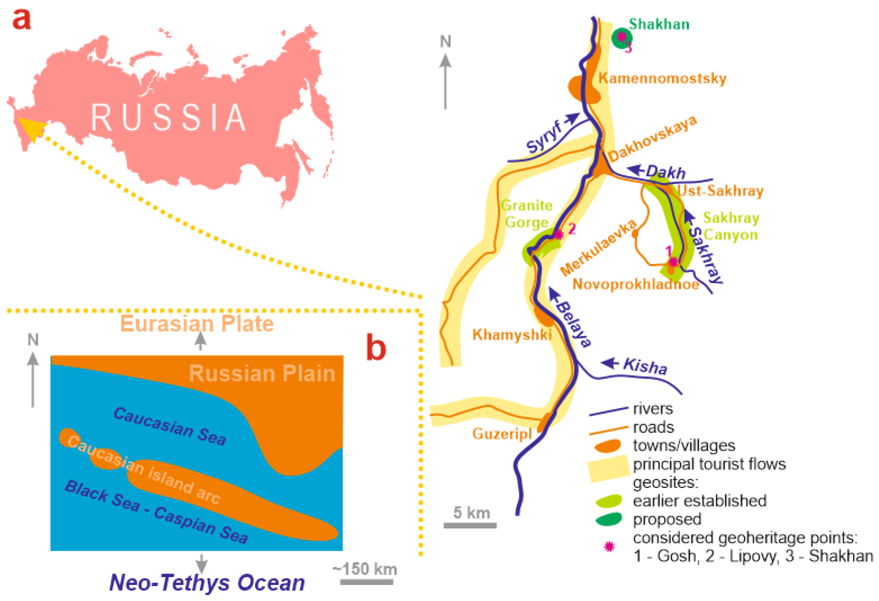
the considered localities are linked to larger geosites (Figure 1a), accessible, and located in natural domains with significant aesthetic properties.
The potential target audience includes university students and their lecturers (Mountainous Adygeya is used actively for field geosciences programs by several large Russian universities), “pure” geotourists (geology amateurs, for whom the study area is very famous), and other tourists (occasional geotourists, either organized or individual) needing to diversify their experience and/or enrich their knowledge (besides the others, these include ecotourists and groups of schoolchildren). Moreover, the thematic geoheritage can be used for organizing irregular pre- and post-conference trips for senior scholars.
The development of geotourist routes is essential in geotourism [83,84,85,86,87,88], and it is especially important when several localities represent the same unique phenomenon and need to be visited in logical order. Earlier, Migoń et al. [89] emphasized the idea of the development of thematic geotourist trails. The development of a geoexcursion route for the discussed thematic geoheritage seems to be an urgent task because such a route can be employed as a basis for local geotourism planning and related geoheritage management. Two main reasons should be taken into account. First, a route should connect the three geoheritage points in logical order, i.e., from the Triassic to the Cretaceous. Second, the geoexcursion should be planned in regard to the location of the main accommodation places, the accessibility of geoheritage points (see above), and the options of access (excursion bus, individual car, and hiking). Field investigations permit the proposal of the geoexcursion route (Figure 8) and the specification of its main parameters (Table 2).
The excursion starts in Kamennomostsky or Dakhovskaya, depending on the geotourists’ choice for accommodation. The local road to Novoprokhladnoe village is used to reach the Gosh geoheritage point representing the Early Triassic palaeoisland. Visiting the latter takes up to an hour. Then, geotourists should return to Dakhvskaya village and follow the main road to the northern entrance to the Granite Gorge, where the Lipovy geoheritage point representing the Early Jurassic palaeoisland is located. It is small and simple enough, and visiting it takes no more than half an hour. The excursion follows the principal road to the northern periphery of Kamennomostsky and then the unpaved road to the abandoned quarry, which is the Shakhan geoheritage point representing the Early Cretaceous palaeoisland. This locality is rather large, and visitors need up to 1.5 h to comprehend it. The excursion ends at the accommodation place. The entire geoexcursion requires ~8 h by bus or ~6.5 h by car. In fact, it can last a bit more or less depending on the driving experience and weather conditions. One hour can be reserved for dinner.
The proposed route can be used from May to October. Although the excursion is planned for the mountainous domain, the height range is minimal (Table 2). An apparently “weak” aspect of the proposal is the significant time required for travelling between the localities (sub-routes A and B in Table 2). However, the entire route crosses a very scenic domain with continuous panoramic views of the geoheritage landscapes of Mountainous Adygeya. Moreover, outcrops of Mesozoic (especially Jurassic) marine deposits are visible in many places along the proposed route (these can be visited briefly if the visitors have interest), and they give an idea of the dominance of the Caucasian Sea in the Mesozoic in the study area. Indeed, the proposed geoexcursion is not restricted to the three geoheritage points in regard to the information available to its participants.
“Visiting” Mesozoic islands of the Caucasian Sea may be an interesting experience to tourists and may also be very informative, enriching their geological knowledge. First of all, the proposed geoexcursion route can be tested with groups of university students who have their field practice in Mountainous Adygeya. When well established, it can be offered to local tourism firms. The latter, however, should receive professionally treated and popularly explained geological information about the geoheritage points. The installation of interpretative panels would also help significantly. The promotion of the route can be carried out by the administrative authorities responsible for tourism development and interested in revenues to local budgets from tourism growth and diversification.

6. Conclusions

The present study of the palaeogeographical features in Mountainous Adygeya allows for three general conclusions:
(1)
evidence of the Induan (Early Triassic), Toarcian (Early Jurassic), and Hauterivian (Early Cretaceous) islands in the Mesozoic Caucasian Sea is gathered;
(2)
the related localities are valuable geoheritage points which open novel thematic perspectives for the geoheritage of Mountainous Adydeya;
(3)
these geoheritage points can be employed for the purposes of new geoexcursion route development, which seems to be important for facilitating the growth of geotourism in the study area.
These conclusions stress the importance of focusing on thematic, sometimes highly specific geoheritage for its effective, logical treatment and touristic exploitation. Indeed, more research is necessary to conceptualize thematic geoheritage and to offer templates for its analysis. Generally, thematic framing seems to be very promising for dealing with marine geoheritage.
Some questions about the features reported in this work remain unresolved:
(1)
Do these three geoheritage points represent the same or different palaeoislands?
(2)
How many palaeoislands were there in the Caucasian Sea and how did they change?
(3)
What was the exact tectonic setting of these palaeoislands?
(4)
Which practical (local infrastructural) solutions are required to exploit these geoheritage points effectively (also in regard to serious interpretation needs)?
(5)
Is it possible to use these localities for geotourists with functional diversity (and if yes, how)?
Indeed, more research is necessary to answer these questions. Notably, performing further research will facilitate interest in the considered localities, which is a factor stimulating academic geotourism. In other words, the very presence of unresolved geological questions makes establishing the related thematic geoheritage important and urgent.

Funding

This research received no external funding.

Institutional Review Board Statement

Not applicable.

Informed Consent Statement

Not applicable.

Data Availability Statement

Not applicable.

Acknowledgments

The author thanks Natalia V. Ruban (Russia) for the field assistance.

Conflicts of Interest

The authors declare no conflict of interest.

References

  1. Poiraud, A.; Chevalier, M.; Claeyssen, B.; Biron, P.-E.; Joly, B. From geoheritage inventory to territorial planning tool in the Vercors massif (French Alps): Contribution of statistical and expert cross approaches. Appl. Geogr. 2016, 71, 69–82. [Google Scholar] [CrossRef]
  2. Migoń, P.; Różycka, M.; Michniewicz, A. Conservation and Geotourism Perspectives at Granite Geoheritage Sites of Waldviertel, Austria. Geoheritage 2018, 10, 11–21. [Google Scholar] [CrossRef]
  3. Herrera-Franco, G.; Mora-Frank, C.; Kovács, T.; Berrezueta, E. Georoutes as a Basis for Territorial Development of the Pacific Coast of South America: A Case Study. Geoheritage 2022, 14, 78. [Google Scholar] [CrossRef]
  4. Plyusnina, E.E.; Ruban, D.A.; Zayats, P.P. Thematic dimension of geological heritage: An evidence from the Western Caucasus. J. Geogr. Inst. Jovan Cvijic SASA 2015, 65, 59–76. [Google Scholar] [CrossRef]
  5. Gnezdilova, V.V.; Ruban, D.A.; Bruno, D.E.; Perrotta, P.; Crowley, B.E.; Oheim, K.B.; Zayats, P.P. Geoheritage sites with palaeogeographical value: Some geotourism perspectives with examples from Mountainous Adygeja (Russia). Geološki Anal. Balk. Poluostrva 2015, 76, 93–104. [Google Scholar] [CrossRef]
  6. Bruno, D.E.; Crowley, B.E.; Gutak, J.M.; Moroni, A.; Nazarenko, O.V.; Oheim, K.B.; Ruban, D.A.; Tiess, G.; Zorina, S.O. Paleogeography as geological heritage: Developing geosite classification. Earth Sci. Rev. 2014, 138, 300–312. [Google Scholar] [CrossRef]
  7. Henriques, M.H.; Pena dos Reis, R.; Garcia, G.G.; João, P.; Marques, R.M.; Custódio, S. Developing paleogeographical heritage concepts and ideas through the Upper Jurassic record of the Salgado and Consolação geosites (Lusitanian Basin, Portugal). Resour. Policy 2022, 76, 102594. [Google Scholar] [CrossRef]
  8. Baarli, B.G.; Webb, G.E.; Johnson, M.E.; Cook, A.G.; Walsh, D.R. Shoal-water dynamics and coastal biozones in a sheltered-island setting: Upper Devonian Pillara Limestone (Western Australia). Lethaia 2016, 49, 507–523. [Google Scholar] [CrossRef]
  9. Johnson, M.E. Paleoislands in the stream: Paleogeography and expected circulation patterns. Geobios 2002, 35, 96–106. [Google Scholar] [CrossRef]
  10. Ollive, V.; Petit, C.; Garcia, J.-P.; Reddé, M. Rhine flood deposits recorded in the Gallo-Roman site of Oedenburg (Haut-Rhin, France). Quat. Int. 2006, 150, 28–40. [Google Scholar] [CrossRef]
  11. Schuster, M.; Duringer, P.; Ghienne, J.-F.; Vignaud, P.; Beauvilain, A.; MacKaye, H.T.; Brunet, M. Coastal conglomerates around the Hadjer El Khamis inselbergs (Western Chad, Central Africa): New evidence for Lake Mega-Chad episodes. Earth Surf. Processes Landf. 2003, 28, 1059–1069. [Google Scholar] [CrossRef]
  12. Adamia, S.; Zakariadze, G.; Chkhotua, T.; Sadradze, N.; Tsereteli, N.; Chabukiani, A.; Gventsadze, A. Geology of the Caucasus: A review. Turk. J. Earth Sci. 2011, 20, 489–544. [Google Scholar] [CrossRef]
  13. Khain, V.E. Mesozoic-Cenozoic accretionary complexes of the Greater Caucasus. Dokl. Earth Sci. 2007, 413, 376–379. [Google Scholar] [CrossRef]
  14. Koronovskiy, N.V. he Caucasus: Unsolved problems of geology. Vestn. Mosk. Univ. Seriya Geol. 1990, 4, 3–11. [Google Scholar]
  15. Mosar, J.; Mauvilly, J.; Koiava, K.; Gamkrelidae, I.; Enna, N.; Lavrishev, V.; Kalberguenova, V. Tectonics in the Greater Caucasus (Georgia—Russia): From an intracontinental rifted basin to a doubly verging fold-and-thrust belt. Mar. Pet. Geol. 2022, 140, 105630. [Google Scholar] [CrossRef]
  16. Rolland, Y. Caucasus collisional history: Review of data from East Anatolia to West Iran. Gondwana Res. 2017, 49, 130–146. [Google Scholar] [CrossRef]
  17. Sharkov, E.; Lebedev, V.; Chugaev, A.; Zabarinskaya, L.; Rodnikov, A.; Sergeeva, N.; Safonova, I. The Caucasian-Arabian segment of the Alpine-Himalayan collisional belt: Geology, volcanism and neotectonics. Geosci. Front. 2015, 6, 513–522. [Google Scholar] [CrossRef]
  18. Sosson, M.; Stephenson, R.; Adamia, S. Tectonic Evolution of the Eastern Black Sea and Caucasus: An introduction. Geol. Soc. Spec. Publ. 2017, 428, 1–9. [Google Scholar] [CrossRef]
  19. Van Hinsbergen, D.J.J.; Torsvik, T.H.; Schmid, S.M.; Matenco, L.C.; Maffione, M.; Vissers, R.L.M.; Gürer, D.; Spakman, W. Orogenic architecture of the Mediterranean region and kinematic reconstruction of its tectonic evolution since the Triassic. Gondwana Res. 2020, 81, 79–229. [Google Scholar]
  20. Yasamanov, N.A. Landscape-Climatic Conditions of the Jurassic, the Cretaceous and the Paleogene of the South of the USSR; Nedra: Moskva, Soviet Union, 1978. (In Russian) [Google Scholar]
  21. Adamia, S.; Alania, V.; Chabukiani, A.; Kutelia, Z.; Sadradze, N. Great Caucasus (Cavcasioni): A long-lived north-tethyan back-arc basin. Turk. J. Earth Sci. 2011, 20, 611–628. [Google Scholar] [CrossRef]
  22. Kazmin, V.G.; Tikhonova, N.F. Evolution of Early Mesozoic back-arc basins in the Black Sea—Caucasus segment of a Tethyan active margin. Geol. Soc. Spec. Publ. 2006, 260, 179–200. [Google Scholar] [CrossRef]
  23. Lordkipanidze, M.B.; Adamia, S.A.; Asanidze, B.Z. Evolution of the active margins of the ocean Tethys (by example of the Caucasus). In Oceanology: Reports. 27 International Geological Congress, 3; Lisitsin, A.P., Ed.; Nauka: Moscow, Russia, 1984; pp. 72–83. (In Russian) [Google Scholar]
  24. McCann, T.; Chalot-Prat, F.; Saintot, A. The Early Mesozoic evolution of the Western Greater Caucasus (Russia): Triassic-Jurassic sedimentary and magmatic history. Geol. Soc. Spec. Publ. 2010, 340, 181–238. [Google Scholar] [CrossRef]
  25. Saintot, A.; Brunet, M.-F.; Yakovlev, F.; Sebrier, M.; Stephenson, R.; Ershov, A.; Chalot-Prat, F.; McCann, T. The Mesozoic-Cenozoic tectonic evolution of the Greater Caucasus. Geol. Soc. Mem. 2006, 32, 277–289. [Google Scholar] [CrossRef]
  26. Ruban, D.A.; Mikhailenko, A.V.; Yashalova, N.N. Valuable geoheritage resources: Potential versus exploitation. Resour. Policy 2022, 77, 102665. [Google Scholar] [CrossRef]
  27. Hasterok, D.; Halpin, J.A.; Collins, A.S.; Hand, M.; Kreemer, C.; Gard, M.G.; Glorie, S. New Maps of Global Geological Provinces and Tectonic Plates. Earth Sci. Rev. 2022, 231, 104069. [Google Scholar] [CrossRef]
  28. Ruban, D.A. The Greater Caucasus—A Galatian or Hanseatic Terrane? Comment on "The formation of Pangea" by G.M. Stampfli, C. Hochard, C. Vérard, C. Wilhemand J. von Raumer Tectonophysics 593 (2013) 1–19]. Tectonophysics 2013, 608, 1442–1444. [Google Scholar] [CrossRef]
  29. Gradstein, F.M.; Ogg, J.G.; Schmitz, M.; Ogg, G. (Eds.) Geologic Time Scale 2020; Elsevier: Amsterdam, Fhe Netherlands, 2020; p. 1390. [Google Scholar]
  30. Ruban, D.A.; Zorina, S.O.; Rebezov, M.B. Dispersed geoheritage points of the Lagonaki Highland, SW Russia: Contribution to local geoheritage resource. Geosciences 2019, 9, 367. [Google Scholar] [CrossRef]
  31. Panek, N. Geotope protection and Geoparks in Germany—A critical inventory. Nat. Und Landsch. 2018, 50, 182–191. [Google Scholar]
  32. Varriale, R.; Genovese, L.; Aldighieri, B. “Diffused Geoparks”: Territorial Integration as Solution for a Shared Sustainable Growth Based on Geotourism in Italy, Japan and Tunisia. Heritage 2022, 5, 2083–2105. [Google Scholar] [CrossRef]
  33. Brilha, J. Inventory and quantitative assessment of geosites and geodiversity sites: A review. Geoheritage 2016, 8, 119–134. [Google Scholar] [CrossRef]
  34. Bruschi, V.M.; Cendrero, A. Geosite evaluation; can we measure intangible values? Alp. Mediterr. Quat. 2005, 18, 293–306. [Google Scholar]
  35. Carcavilla, L.; Díaz-Martínez, E.; Erikstad, L.; García-Cortés, Á. Valuation of geoheritage in Europe. Bol. Parana. Geosci. 2013, 70, 28–40. [Google Scholar]
  36. Carrión-Mero, P.; Dueñas-Tovar, J.; Jaya-Montalvo, M.; Berrezueta, E.; Jiménez-Orellana, N. Geodiversity assessment to regional scale: Ecuador as a case study. Environ. Sci. Policy 2022, 136, 167–186. [Google Scholar] [CrossRef]
  37. Mucivuna, V.C.; Motta Garcia, M.D.G.; Reynard, E. Comparing quantitative methods on the evaluation of scientific value in geosites: Analysis from the Itatiaia National Park, Brazil. Geomorphology 2022, 396, 107988. [Google Scholar] [CrossRef]
  38. Ruban, D.A. On the duality of marine geoheritage: Evidence from the Abrau area of the Russian Black Sea coast. J. Mar. Sci. Eng. 2021, 9, 921. [Google Scholar] [CrossRef]
  39. Štrba, L.; Rybar, P.; Balaz, B.; Molokac, M.; Hvizdak, L.; Krsak, B.; Lukac, M.; Muchova, L.; Tometzova, D.; Ferencikova, J. Geosite assessments: Comparison of methods and results. Curr. Issues Tour. 2015, 18, 496–510. [Google Scholar] [CrossRef]
  40. Mikhailenko, A.V.; Ruban, D.A.; Ermolaev, V.A. Geoheritage meaning of artificial objects: Reporting two new examples from Russia. Heritage 2021, 4, 2721–2731. [Google Scholar] [CrossRef]
  41. Kirillova, K.; Fu, X.; Lehto, X.; Cai, L. What makes a destination beautiful? Dimensions of tourist aesthetic judgment. Tour. Manag. 2014, 42, 282–293. [Google Scholar] [CrossRef]
  42. Chaitsky, V.P.; Popkov, V.I.; Popkov, I.V.; Pinchuk, T.N. Triassic of the Northern Caucasus. Geol. Geogr. I Glob. Energiya 2020, 77, 11–21. (In Russian) [Google Scholar]
  43. Gaetani, M.; Garzanti, E.; Poline, R.; Kiricko, Y.; Korsakhov, S.; Cirilli, S.; Nicora, A.; Rettori, R.; Larghi, C.; Bucefalo Palliani, R. Stratigraphic evidence for Cimmerian events in NW Caucasus (Russia). Bull. Société Géologique Fr. 2005, 176, 283–299. [Google Scholar] [CrossRef]
  44. Rostovtsev, K.O.; Savel’eva, L.M.; Efimova, N.A.; Shvemberger, Y.N. Decision of the 2nd Interdepartmental Regional Stratigraphical Maeeting on the Mesozoic of the Caucasus (Triassic); VSEGEI: Leningrad, Russia, 1979. (In Russian) [Google Scholar]
  45. Callahan, G.; Johnson, M.E.; Guardado-France, R.; Ledesma-Vázquez, J. Upper Pleistocene and Holocene storm deposits eroded from the granodiorite coast on Isla San Diego (Baja California Sur, Mexico). J. Mar. Sci. Eng. 2021, 9, 555. [Google Scholar] [CrossRef]
  46. Dewey, J.F.; Ryan, P.D. Storm, rogue wave, or tsunami origin for megaclast deposits in western Ireland and North Island, New Zealand? Proc. Natl. Acad. Sci. USA 2017, 114, E10639–E10647. [Google Scholar] [CrossRef] [PubMed]
  47. Johnson, M.E.; Ledesma-Vázquez, J. Evaluation of boulder deposits linked to late Neogene hurricane events. J. Mar. Sci. Eng. 2021, 9, 1278. [Google Scholar] [CrossRef]
  48. Lorang, M.S. A wave-competence approach to distinguish between boulder and megaclast deposits due to storm waves versus tsunamis. Mar. Geol. 2011, 283, 90–97. [Google Scholar] [CrossRef]
  49. Noormets, R.; Felton, E.A.; Crook, K.A.W. Sedimentology of rocky shorelines: 2 Shoreline megaclasts on the north shore of Oahu, Hawaii—origins and history. Sediment. Geol. 2002, 150, 31–45. [Google Scholar] [CrossRef]
  50. Oliveira, M.A.; Andrade, C.; Freitas, M.C.; Costa, P.; Taborda, R.; Janardo, C.; Neves, R. Transport of large boulders quarried from shore platforms of the Portuguese west coast. J. Coast. Res. 2011, 64, 1871–1875. [Google Scholar]
  51. Terry, J.P.; Lau, A.Y.A.; Nguyen, K.A.; Liou, Y.-A.; Switzer, A.D. Clustered, Stacked and Imbricated Large Coastal Rock Clasts on Ludao Island, Southeast Taiwan, and Their Application to Palaeotyphoon Intensity Assessment. Front. Earth Sci. 2021, 9, 792369. [Google Scholar] [CrossRef]
  52. Ruban, D.A. The Permian/Triassic mass extinction among brachiopods in the Northern Caucasus (northern Palaeo-Tethys): A tentative assessment. Geobios 2010, 43, 355–363. [Google Scholar] [CrossRef]
  53. Haq, B.U. Triassic Eustatic Variations Reexamined. GSA Today 2018, 28, 4–9. [Google Scholar] [CrossRef]
  54. Ruban, D.A. Basal Liassic of the Belaya River watershed (North-Western Caucasus). Nautchnaja Mysl’ Kavkaza. Mezhdistsiplinarnye I Spetsial’nye Issled. 2007, 2, 95–97. (In Russian) [Google Scholar]
  55. Nenakhov, V.M.; Zhabin, A.V.; Nikitin, A.V.; Bondarenko, S.V. Internal structure of the tectonic zone of the northern frame of the Dakh Crystalline Massif (Western Caucasus). Vestn. Voronezhskogo Gos. Universiteta. Seriya Geol. 2019, 1, 5–14. (In Russian) [Google Scholar]
  56. Chepurnoy, E.A. Sedimentary rocks of the northern contact of the Dakh Crystalline Uplift (Adygeya). In Praktika Geologov na Proizvodstve; Granovskaya, N.V., Ed.; SFU: Rostov-on-Don, Russia, 2021; pp. 132–134. (In Russian) [Google Scholar]
  57. Rostovtsev, K.O.; Agaev, V.B.; Azarian, N.R.; Babaev, R.G.; Besnosov, N.V.; Hassanov, N.A.; Zesashvili, V.I.; Lomize, M.G.; Paitschadze, T.A.; Panov, D.I.; et al. Jurassic of the Caucasus; Nauka: St. Petersburg, Russia, 1992. (In Russian) [Google Scholar]
  58. Panov, D.i.; Stafeev, A.N.; Yutsis, V.V. Early Jurassic stage in the development of the Northern Caucasus and the Ciscaucasus. Bull. Mosc. Soc. Naturalists. Geol. Ser. 1996, 6, 3–14. (In Russian) [Google Scholar]
  59. Karpunin, A.M.; Mamonov, S.V.; Mironenko, O.A.; Sokolov, A.R. Geological Monuments of Nature of Russia; Lorien: Sankt-Peterburg, Russia, 1998. (In Russian) [Google Scholar]
  60. Mikhailenko, A.V.; Ruban, D.A.; Yashalova, N.N.; Rebezov, M.B. The Unique Granite Gorge in Mountainous Adygeya, Russia: Evidence of Big and Complex Geosite Disproportions. Geosciences 2019, 9, 372. [Google Scholar] [CrossRef]
  61. Drushits, V.V.; Mikhailova, I.A. Biostratigraphy of the Lower Cretaceous of the Northern Caucasus; MGU: Moscow, Soviet Union, 1966. (In Russian) [Google Scholar]
  62. Prosorovskaya, E.L. (Ed.) Stratigraphical Dictionary of the USSR. Triassic, Jurassic, Cretaceous; Nedra: Leningrad, Soviet Union, 1979. (In Russian) [Google Scholar]
  63. Mikerina, T.B.; Pinchuk, T.N. Facies of Cretaceous deposits of the northern part of the Western Ciscaucasus. In Melovaya Sistema Rossii i Blizhnego Zarubezh’ya: Problemy Stratigrafii i Paleogeografii; Baraboshkin, E.Y., Guzhikov, A.Y., Eds.; MAOBTI: Magadan, Russia, 2020; pp. 171–174. (In Russian) [Google Scholar]
  64. Wakita, K. Geology and tectonics of Japanese islands: A review—The key to understanding the geology of Asia. J. Asian Earth Sci. 2013, 72, 75–87. [Google Scholar] [CrossRef]
  65. Seghedi, A.; Andrășanu, A.; Rădan, S. The Transylvanian dinosaur museum project: The contribution of Geoecomar to valorize and promote the paleontological heritage of Romania. Geo. Eco. Mar. 2017, 23, 145–164. [Google Scholar]
  66. Wolniewicz, P. Bringing the History of the Earth to the Public by Using Storytelling and Fossils from Decorative Stones of the City of Poznań, Poland. Geoheritage 2019, 11, 1827–1837. [Google Scholar] [CrossRef]
  67. Bratton, A.; Smith, B.; McKinley, J.; Lilley, K. Expanding the Geoconservation Toolbox: Integrated Hazard Management at Dynamic Geoheritage Sites. Geoheritage 2013, 5, 173–183. [Google Scholar] [CrossRef]
  68. Cayla, N. An Overview of New Technologies Applied to the Management of Geoheritage. Geoheritage 2014, 6, 91–102. [Google Scholar] [CrossRef]
  69. de Oliveira, G.H.; Servidoni, L.E.; Spalevic, V.; Gaspar Junior, L.A.; Mincato, R.L. Geological heritage management and preservation instruments: Case study of the municipality of Conceicao da Aparecida, Minas Gerais—Brazil. Agric. For. 2021, 567, 71–82. [Google Scholar]
  70. Erikstad, L. Geoheritage and geodiversity management—the questions for tomorrow. Proc. Geol. Assoc. 2013, 124, 713–719. [Google Scholar] [CrossRef]
  71. Fuertes-Gutiérrez, I.; García-Ortiz, E.; Fernández-Martínez, E. Anthropic Threats to Geological Heritage: Characterization and Management: A Case Study in the Dinosaur Tracksites of La Rioja (Spain). Geoheritage 2016, 8, 135–153. [Google Scholar] [CrossRef]
  72. Lech, R.R.; Marcus, A.; Reinoso, J.R. Science and tourism together in the management for the preservation of the geological heritage. Ser. Correl. Geol. 2018, 34, 35–41. [Google Scholar]
  73. Lima, E.A.; Machado, M.; Guerreiro, M.; Nunes, J.C.; Costa, M.P. Geological Heritage Management in Small Islands: The Example of the Azores UNESCO Global Geopark (Portugal). Geoheritage 2018, 10, 659–671. [Google Scholar] [CrossRef]
  74. Mucivuna, V.C.; Garcia, M.D.G.M.; Reynard, E.; Rosa, P.A.D.S. Integrating geoheritage into the management of protected areas: A case study of the Itatiaia National Park, Brazil. Int. J. Geoheritage Parks 2022, 10, 252–272. [Google Scholar] [CrossRef]
  75. Pál, M.; Albert, G. Examining the Spatial Variability of Geosite Assessment and Its Relevance in Geosite Management. Geoheritage 2021, 13, 8. [Google Scholar] [CrossRef]
  76. Prosser, C.; Murphy, M.; Larwood, J. Geological Conservation: A Guide to Good Practice; English Nature: Peterborough, UK, 2006.
  77. Reynard, E.; Brilha, J. (Eds.) Geoheritage: Assessment, Protection, and Management; Elsevier: Amsterdam, The Netherlands, 2018. [Google Scholar]
  78. Spyrou, E.; Triantaphyllou, M.; Tsourou, T.; Vassilakis, E.; Asimakopoulos, C.; Konsolaki, A.; Markakis, D.; Marketou-Galari, D.; Skentos, A. Assessment of Geological Heritage Sites and Their Significance for Geotouristic Exploitation: The Case of Lefkas, Meganisi, Kefalonia and Ithaki Islands, Ionian Sea, Greece. Geosciences 2022, 12, 55. [Google Scholar] [CrossRef]
  79. Began, M.; Visnic, T.; Djokic, M.; Vasiljevic, D.A. Interpretation Possibilities of Geoheritage in Southeastern Serbia—Gorge and Canyon Study. Geoheritage 2017, 9, 237–249. [Google Scholar] [CrossRef]
  80. Bruno, B.C.; Wallace, A. Interpretive Panels for Geoheritage Sites: Guidelines for Design and Evaluation. Geoheritage 2019, 11, 1315–1323. [Google Scholar] [CrossRef]
  81. Hose, T.A. 3G’s for Modern Geotourism. Geoheritage 2012, 4, 7–24. [Google Scholar] [CrossRef]
  82. Dzhimova, S.B.; Bayanduryan, G.L. Evaluation of tourism complex functioning in the Republic of Adygeya. Ekon. I Predprin. 2021, 127, 418–421. (In Russian) [Google Scholar]
  83. Abratis, M.; Viereck, L.; Büchner, J.; Tietz, O. Route to the volcanoes in Germany—conceptual model for a geotourism project interconnecting geosites of Cenozoic volcanism. Z. Der Dtsch. Ges. Fur Geowiss. 2015, 166, 161–185. [Google Scholar] [CrossRef]
  84. Bentivenga, M.; Palladino, G.; Prosser, G.; Guglielmi, P.; Geremia, F.; Laviano, A. A Geological Itinerary Through the Southern Apennine Thrust Belt (Basilicata—Southern Italy). Geoheritage 2017, 9, 1–17. [Google Scholar] [CrossRef]
  85. Bucci, F.; Tavarnelli, E.; Novellino, R.; Palladino, G.; Guglielmi, P.; Laurita, S.; Prosser, G.; Bentivenga, M. The History of the Southern Apennines of Italy Preserved in the Geosites Along a Geological Itinerary in the High Agri Valley. Geoheritage 2019, 11, 1489–1508. [Google Scholar] [CrossRef]
  86. Dóniz-Páez, J.; Alonso, C.Q. Urban geoturism rutes in Icod de Los Vinos (Tenerife, Canary Islands, Spain): A proposal. Cuad. Geogr. 2016, 55, 320–343. [Google Scholar]
  87. Gałka, E. Geotourist potential of the loess relief of the projected Kamienna Valley Geopark. Prz. Geol. 2018, 66, 55–64. [Google Scholar]
  88. Palladino, G.; Prosser, G.; Bentivenga, M. The Geological Itinerary of Sasso di Castalda: A Journey into the Geological History of the Southern Apennine Thrust-belt (Basilicata, Southern Italy). Geoheritage 2013, 5, 47–58. [Google Scholar] [CrossRef]
  89. Migoń, P.; Duszyński, F.; Jancewicz, K.; Różycka, M. From Plateau to Plain—Using Space-for-Time Substitution in Geoheritage Interpretation, Elbsandsteingebirge, Germany. Geoheritage 2019, 11, 839–853. [Google Scholar] [CrossRef] [Green Version]
Figure 1. Geographical location of the study area, with focus on touristic infrastructure and geoheritage (a), and the general outline of the Mesozoic Caucasian Sea between the rather stable landmass in the north and the active island arc in the south (b).
Jmse 10 01300 g001
Figure 2. Gosh locality: geological scheme and principal Triassic lithologies (hammer’s length is 40 cm).
Jmse 10 01300 g002
Figure 3. An unpaved scenic road leading to Novoprokhladnoe from Dakhovskaya.
Jmse 10 01300 g003
Figure 4. Lipovy locality: geological scheme and principal Jurassic lithology (hammer’s length is 40 cm). The nature of the contact between crystalline rocks and overlying Jurassic deposits shown on the scheme is not clear everywhere (it can be transgressive and tectonic).
Jmse 10 01300 g004
Figure 5. The “entrance” to the valley of the Lipovy River from the road; the dense vegetation and tree cover should be noted.
Jmse 10 01300 g005
Figure 6. Shakhan locality: geological schemes and principal Cretaceous lithology with well-visible layering and cross-bedding (tape’s length is 2 m).
Jmse 10 01300 g006
Figure 7. The lower part of the Shakhan geoheritage point, with an unpaved road leading to it from Kamennomostsky (the road is visible on the right).
Jmse 10 01300 g007
Figure 8. The proposed geoexcursion route connecting the considered geohertage points representing Mesozoic islands of the Caucasian Sea.
Jmse 10 01300 g008
Table 1. Template for characterizing geoheritage points.
Elements/CriteriaEssenceSignificance
NameName of geoheritage point, which may or may not correspond to the name of the geositeBasic
Geological outlineBrief geological characteristics (descriptions and interpretations) based on field investigations and literary evidence
Thematic outlineRelevance of geological peculiarities to thematic geoheritage
Spatial correspondence to geositeFull correspondence, partial correspondence, or a tiny portion of a geositeEssential
Novelty of geosite *Earlier-established geosite, newly proposed geosite, tentatively proposed geosite needing further examination
Contribution to geosite uniquenessWhether this locality determines geosite uniqueness fully, partly, or minimally
ComplexityCoexistence of several geoheritage typesTechnical
CohesionIsolated position within the geosite or continuous links to the geosite
AccessibilityOuter and inner accessibility (sensu [40]) and seasonality of access
VulnerabilityNo danger, potential danger, partial damage, or significant damage; danger/damage factor active or inactive
Interpretation needsClear to non-experts or only experts; professional guidance required or not
AestheticsAesthetic-related features and their relative appeal to visitors’ sense of beauty (see aesthetic properties in [41])
ImportanceInteresting to research audience, students or schoolchildren, and touristsUtilitarian
Note: all items are related to a given geoheritage point, except for that marked by an asterisk and related to the entire geosite.
Table 2. Parameters of the proposed geoexcursion.
Elements
(see Figure 8 for More Information)
Approximate Time, h
(Taking into Account the Quality of Roads)
Distance, kmHeight Range, m
Bus *CarHiking, Examining, and Discussing
K -> Attraction 11.51-30<200
D -> Attraction 110.7-20<200
Attraction 1--10.3<25
Sub-route A1.51-30~100
Attraction 2--0.50.1<10
Sub-route B1.51-35~200
Attraction 3--1.50.5<25
Attraction 3 -> D10.7-15~200
Attraction 3 -> K0.50.5-5~200
Note: a relatively small bus suitable for driving unpaved roads and well-experienced, local drivers are preferred.
Publisher’s Note: MDPI stays neutral with regard to jurisdictional claims in published maps and institutional affiliations.

