Article

A Multi-Level Analysis of Risky Streets and Neighbourhoods for Dissident Republican Violence in Belfast

1
Department of Security and Crime Science, University College London, London WC1H 9EZ, UK
2
Department of Sociology and Human Geography, University of Oslo, 0851 Oslo, Norway
3
Department of Law and Criminology, Royal Holloway, University of London, Egham TW20 0EX, UK
*
Author to whom correspondence should be addressed.
ISPRS Int. J. Geo-Inf. 2021, 10(11), 765; https://0-doi-org.brum.beds.ac.uk/10.3390/ijgi10110765
Submission received: 23 August 2021 / Revised: 27 October 2021 / Accepted: 8 November 2021 / Published: 11 November 2021
(This article belongs to the Special Issue Geographic Crime Analysis)

Abstract

:
This paper uses graph theoretical measures to analyse the relationship between street network usage, as well as other street- and area-level factors, and dissident Republican violence in Belfast. A multi-level statistical model is used. Specifically, we employ an observation-level random-effects (OLRE) Poisson regression and use variables at the street and area levels. Street- and area-level characteristics simultaneously influence where violent incidents occur. For every 10% change in the betweenness value of a street segment, the segment is expected to experience 1.32 times as many incidents. Police stations (IRR: 22.05), protestant churches (IRR: 6.19) and commercial premises (IRR: 1.44) on each street segment were also all found to significantly increase the expected number of attacks. At the small-area level, for every 10% change in the number of Catholic residents, the number of incidents is expected to be 4.45 times as many. The results indicate that along with other factors, the street network plays a role in shaping terrorist target selection. Streets that are more connected and more likely to be traversed will experience more incidents than those that are not. This has important practical implications for the policing of political violence in Northern Ireland generally and for shaping specific targeted interventions.

1. Introduction

Criminological research on terrorism and other forms of political violence has recently increased. Although major advances have occurred, notable gaps still exist. Studies focused on terrorist target selection have identified incident hotspots through a number of means including simply identifying areas with high frequencies or rates, or by using more sophisticated techniques such as kernel density estimation [1] or considering the environmental backcloth with the use of risk terrain modelling [2,3,4,5]. A problem with these approaches, however, is that they largely ignore a key factor influencing where crimes occur: the street network.
From a crime pattern theory perspective, a city’s street network is worth considering. It largely determines the routes that people can take during their daily lives, and therefore shapes their awareness space [6]. Offences will occur when this awareness space overlaps with an opportunity for criminal activity. Typically, more accessible streets, where urban movement will be highest, experience more crime [7,8,9,10,11,12,13,14,15,16].
Just like typical offenders, terrorists require opportunity structures to select their targets. Anecdotal research suggests that terrorists are also more likely to target areas that are easily accessible. As well as considering effort, the risk of interception before an attack will also be deliberated [17]. However, little has been done to empirically demonstrate the influence of accessibility (with the exception of Marchment and Gill [4]).
In this study, graph theoretical measures are used to analyse the street network to identify risky streets for dissident Republican violence in Belfast. In particular, we examine the relationship between violent incidents and the network metric ‘betweenness’. This metric measures the frequency with which parts of the street network feature in the shortest paths through the network and, as employed in other criminological studies [18,19], approximately represents which locations are most likely to be traversed in terms of traffic [20]. In doing so, this study is the first to demonstrate the link between politically violent activity and the urban layout and street network.

1.1. Theory

The environmental criminology framework encompasses several mutually compatible perspectives seeking an understanding of crime events. Collectively, rational choice perspectives, routine activity theory and crime pattern theory suggest that offenders actively select areas and targets in a way that minimises effort and risks and maximises rewards.
The rational choice perspective [21] describes offenders as nonarbitrary decision makers who consider the costs and benefits of action alternatives [22]. For example, the likelihood of an offender selecting an offending location is inversely proportional to the distance they must travel to reach it [23,24]. Their decision making will be bounded by imperfect and incomplete information, and the outcome of previous decisions may inform future choices [21,25,26,27].
Routine activities theory suggests that crimes occur when a motivated offender, a suitable target and a lack of a capable guardian coalesce in time and space [28]. These three factors come together naturally as individuals go about their daily routines. The environment shapes these interactions. Since its introduction, routine activities theory has experienced several extensions [29,30,31,32,33]. Studies initially applied it alongside the rational choice perspective to volume crimes life burglary and shoplifting [27,34]. From the early 1990s, the perspectives were successfully applied to other volume crimes such as drug dealing [35], white-collar crime [36,37], gang membership and violence [38], organised crime [39] and carjacking [40] as well as non-acquisitive offences such as sex offending [41,42] and violent offences [43]. The consensus suggests that offenders ‘read’ their immediate environment to guide their decisions in the commission of their offence.
Brantingham and Brantingham [44] expanded on the rational choice and routine activities theories with crime pattern theory to understand crime events with a spatio-temporal approach. They theorised that as an individual navigates their city or town on their journeys to and from their daily activity nodes (including places such as their home, places of work and/or education, and leisure and recreation venues) they will become more familiar with certain areas. Over time, their increased knowledge and familiarity with these areas means they become part of an individual’s awareness space. Offences will occur when this space overlaps with an opportunity for criminal activity. This leads to patterns in which individuals commit crime in areas known to them [45,46,47,48,49,50,51,52,53,54,55,56]. To travel further beyond their awareness space to commit an offence would mean increased time and effort for the offender. This would also increase the level of perceived risk due to their unfamiliarity with the area. Offending in areas they are familiar with reduces the individual’s risk of detection and interception.
A city’s street network largely determines the routes people can take between locations, and as such shapes movement patterns. As a result, particular street segments are more accessible and are more likely to be traversed, including by offenders, and so are more likely to be familiar and part of offenders’ activity spaces [57]. These spatially defined movement potentials account for approximately 60% of the differences in pedestrian movement flows and about 70% of vehicular flows [58]. Furthermore, numerous studies have demonstrated the link between this, in terms of high connectivity/through-movement, and different forms of crime by employing a range of methodologies and indicators of connectivity [9,10,12,13,57,58,59,60]. Interestingly, contiguous street segments can have very different crime volumes [59] and the types of streets least likely to experience urban crimes are cul-de-sacs and private roads [8,60], even when accounting for factors such as levels of deprivation.
For the most part, the above studies have used a variety of relatively basic measures to measure street connectivity. More recent studies have focused on the betweenness metric. This is derived by identifying the shortest paths between all street segments (sections of streets between junctions and/or street end-points) in the network, and then counting how frequently each street segment features. Using this metric, Davies and Johnson [18] estimated the likely movement of people through street segments for the city of Birmingham, UK. They found a positive association between estimated street-segment usage and burglary risk. Summers and Johnson [16] and Frith et al. [19] found the same pattern for outdoor serious violence in London (UK) and burglaries in Buckinghamshire (UK), respectively.

1.2. Target Accessibility and Terrorism

Studies consistently support the position that terrorists are rational actors [61,62,63,64,65,66,67,68] and that their decision making follows an inherent logic [4,5,17,69,70]. The spatial distributions of terrorist attacks are non-random. Studies incorporated a consideration of how the environmental backcloth [44] shapes target selection through the use of methods such as risk terrain modelling. Risk terrain modelling assesses the spatial influence of features of the urban landscape and identifies areas where criminal activity is likely to emerge or persist [71]. Onat [2] identified areas that were at risk of terrorist attacks in Istanbul. He found the riskiest factor in the urban environment to be the presence of bakeries. Bakeries have a social meaning in Turkish culture, are visited frequently by most residents and therefore have a role in an individual’s daily routine. Marchment et al.’s [5] analysis of risk factors of bombings and bomb hoaxes in Belfast indicated they were more likely to occur in areas where other paramilitary activity, such as punishment attacks, protests and riots had previously occurred. This suggests that individuals are more likely to attack in places they know. However, considerations of how a city’s street network shapes terrorist behaviour has largely been neglected.
Crime pattern theory suggests that streets that are more likely to be travelled upon may be more likely to experience incidents. Disparate and anecdotal findings suggest that target accessibility through road usage is a crucial component of terrorist target selection [72]. Major roads facilitate travel around the city and as such an individual’s familiarity with the area surrounding major thoroughfares is increased [72]. Berman and Laitin [73] discuss the importance of accessibility through road usage in the target selection process: “Settlers and soldiers use roads that pass through heavily populated areas or through terrain that is easily attacked. The result is that an attacker can fire a weapon or detonate a bomb remotely in such a way that makes escape relatively easy afterwards” [73], p. 144. Torres-Soriano’s [74] case study of a terrorist cell in Barcelona examined target selection processes. They found that the flow of traffic around the city determined which buildings the terrorists could photograph from their cars, and as such influenced the identification of potential targets. The author also notes that one member of the cell, Said Touay, focused on a particular police station as it was visible from the car on a routine journey he made. Marchment and Gill [4] found that the presence of a major road increasing the likelihood of an area being chosen by the Provisional Irish Republican Army (PIRA) as a target by a factor of 1.77. Similarly, dissident Republican incidents have been found to occur in close proximity to major roads [1].
Ozer and Akbas [75] suggest that the reason one of the major police stations in Istanbul, Turkey, is targeted by terrorists is because this station is connected by major streets. Using Clarke and Neman’s EVIL DONE framework, they found that all of the buildings targeted by the Partiya Karekeren Kurdistan (PKK) during the period studied were easily accessible. Using the same framework, Gruenewald et al. [76] found a preference for ‘accessible’ (those that were routinely frequented) targets for eco-terrorists in the U.S. Zhukov [77] demonstrated the importance of road networks in a study of insurgent activity in North Caucasus and concluded that they were the most important determining factor for the location of attacks. Rokem et al. [78] found that violence in Jerusalem occurred close to the most connected parts of the city. Schuurmann et al. [79] found that in cases where lone actors considered several targets, a constraining factor was the accessibility of the target.
We therefore estimate that street segments that facilitate movement through the network (as estimated by betweenness) will experience higher numbers of incidents.

2. Materials and Methods

2.1. Study Data

We chose the City of Belfast, Northern Ireland to examine the influence of the street network on incidents. The current nationalist threat in Northern Ireland has emerged from multiple and distinct dissident Republican groups who reject the constitutional compromise accepted by the Provisional Irish Republican Army (PIRA) leadership in the 1997 final ceasefire. Collectively, dissident Republican organisations maintain that the only acceptable outcome is the complete reunification of the island of Ireland. For the purposes of this analysis, the study area was selected as it has experienced the most dissident Republican incidents (approximately one-third of all incidents in Northern Ireland).
The principle strategy of violent dissident Republicans (VDRs) is to undermine the regime created by the 1998 Good Friday Agreement in a number of ways including: obstructing its institutions, seeking to increase British Army presence on the streets, offering alternative policing functions, seeking to recruit young members of the Catholic community, targeting Catholic members of the security and police forces and ultimately by precluding the establishment of a normalised existence. In essence, they hope to unequivocally demonstrate that the agreement has failed.
However, they have been unable to undertake an intense and high-profile campaign of violence due to their lack of comparable capability to PIRA. Instead, they use persistent and often low-level violence to shatter any illusion of peace and to occupy the resources of the police services.

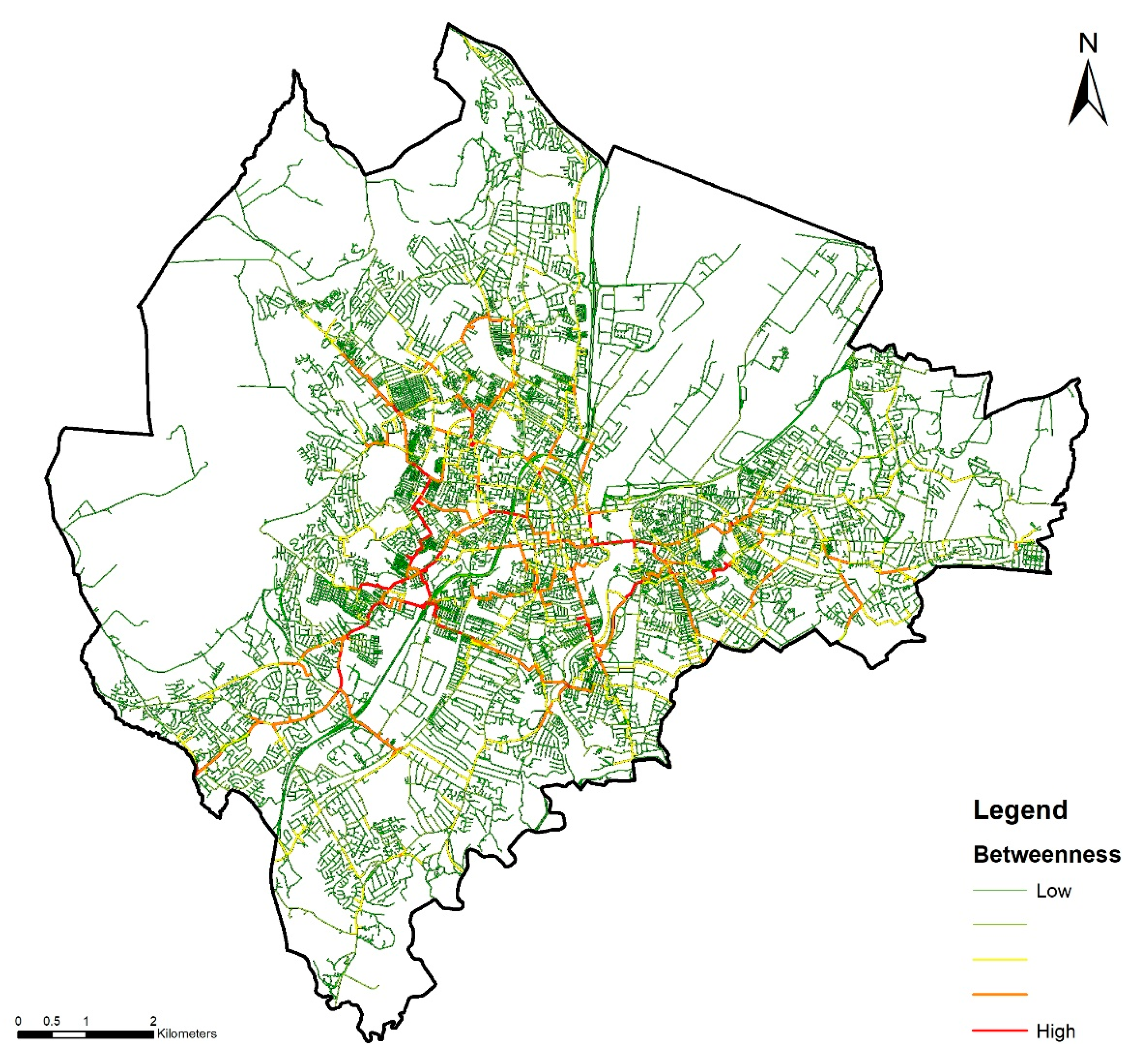
2.2. Study Area and Units of Analysis

As shown in Figure 1 and located in Northern Ireland (UK), the 2011 City of Belfast area, is used as the study area. The primary unit of analysis is derived using the Belfast street network from OpenStreetMap (www.openstreetmap.org), obtained in 2018 (see also Figure 2). Here, although the continuous street network can be converted to discrete sections or units of analysis in a number of ways [80] because we are estimating traffic (see also later), these units should have relatively consistent traffic along their length. As such, and following the typical approach in criminological studies [18,19,81], because movement around the urban area is largely constrained by streets and where they intersect other streets, we use the sections of the street network between intersections (street segments) as the primary unit of analysis. In total, there are 15,886 street segments in the study area.
Whilst most of the factors expected to influence incident locations are expected to do so at the street-segment level and can be measured so (e.g., the locations of police stations), there are other factors where this level of precision does not exist. For example, the concentrations of religions which is only known at some aggregate level (e.g., using Census boundaries). Additionally, some factors, which are also expected to have an effect at the street-segment level, are also anticipated to influence incident locations more generally based on their overall concentration nearby (e.g., the overall number of police stations in the area). Accordingly, a hierarchical or multi-level design is used and the secondary unit of analysis (or level-2 unit given that street segments are level-1) are 2011 ‘small areas’ (also shown in Figure 1) which are the smallest units that these data can be calculated. Northern Ireland has been divided into 4537 small areas (SAs) since 2011, which are currently the smallest geographical unit above streets. They were designed specifically for statistical purposes and follow physical features of the environment such as roads and rivers [82]. They are equivalent to ‘output areas’ used in England, Scotland and Wales. In total, there are 828 small areas in the study area.

2.3. Incident Data

Although the field of terrorism studies is becoming increasingly more empirically oriented, a major problem that remains is a distinct lack of reliable and detailed data due to the obvious clandestine nature of the subject. The data of incidents for this paper were obtained from a previously compiled dataset created for the ‘Violent Dissident Republican Project’ [83] and has been updated regularly since [84]. It was created using open sources and at the time of analysis contained dissident Republican incidents in Northern Ireland from 1990 until the end of 2016. The full dataset consists of violent (e.g., bombings, shootings) and non-violent (e.g., statements and meetings) incidents and includes information regarding the date and time of the incident, the location of the incident, incident type, victim type, and so on. For the purposes of this analysis, we use the number of violent incidents at the street-segment level. We do this for the period of January 2007 to December 2016 which covers the most recent contemporary wave (of attacks) [84] due to its relevance for practitioners. In total, there were 188 incidents in the study area in the time period.

2.4. Methods

2.4.1. Betweenness Calculation

The first independent variable is the graph theoretic measure of betweenness (Freeman, 1977). As shown in [58,84,85] and used in previous criminological research studies [18,19], betweenness can be used to estimate the likely usage of street segments by traffic travelling through the network. In terms of its calculation and the nomenclature, a graph or network is defined as G = ( V ,   E ) and consists of vertices, V = { v 1 , , v n } , and edges between vertices, E = { e 1 , e n } . Because our interest lies in estimating the usage of street segments, we build this graph using a dual representation [85,86]. That is where street intersections are represented as edges in the graph and the street segments are represented by vertices. Given this notation, and that a path between vertices (or street segments) i and j is represented by i ~ j , the distance of this path (or more precisely the distance between the centroids of i and j ) is d i j , the number of the shortest routes between the two vertices is σ i j and the number passing through e is σ i j ( e ) , the betweenness of vertex e is given as:
B e = i , j V ,     i ~ j σ i j ( e ) σ i j
This is such that the betweenness for segment e is the total number of shortest paths between all vertices (represented by i and j) that pass through it (e), adjusted by if there are multiple shortest routes between any vertices. This includes the end-points of each of the shortest paths. In non-mathematical terms, if people move through the network approximately from all segments to all others by taking the shortest route, B e   is the total movement passing through e. In other words, an estimate of the expected amount of traffic on that street segment (e).
Although other modifications of this measure are also possible [19] here we make one change in that the current metric considers movement between all segments in the network. However, these segments can be far away and so little travel (or interaction) between them would be expected. We therefore limit travel (paths) to 5 km as per Davies and Johnson [18] and so the metric captures general traffic, which is perhaps likely to be by vehicle, around Belfast. In graph theoretic terms, this is such that if distance is measured in kilometres then d i j < 5 and betweenness as used in this study is calculated by:
B e = i , j V ,     i ~ j , d i j < 5 σ i j ( e ) σ i j
To check the sensitivity of the results to the radius, we also compute the metric using a limit of 2 km which more relates to maximum on-foot journey lengths and as used in Frith et al. (2017). The results from our main model using this metric are shown in Appendix A but as the results are very similar, they are not discussed further. Note that because this metric involves calculating paths to and from each segments up to 5 km away, a temporary buffer, of 5 km here, must be added to the Belfast study area for the calculation of this metric. This buffer area is then removed. The betweenness values for each street segment in Belfast are shown in Figure 2. Note that as raw betweenness values have no natural scale in which to interpret them, following Frith et al. (2017), in our models, the values are normalised to the range 0–100 using to the road with the greatest betweenness level.

2.4.2. Other Independent Variables

In addition to the betweenness metric, there are 10 other independent variables which are expected to influence incident locations. The first of these are the locations of police stations (Police Service of Northern Ireland) in Belfast which are being operationalised in two ways. The first, by the number of police stations on each street segment (the level-1 unit). Secondly, by the number in each small area (the level-2 unit). The locations of the police stations were obtained from an existing dataset created by Morrison.
The next variables regard the locations of Catholic and Protestant churches which are again being operationalised based on their count of each street segment and in each small area. These data come from Open Data NI (www.opendatani.gov.uk).
As a measure of the attractiveness of the crime generators, we also include data on the number of premises which in this analysis includes shops, cafes and restaurants, and pubs and bars as obtained from Open Data NI. As with the police station and church data, these data are being included in the model in terms of the count of premises on each street segment and in each small area.
Because the same data (on the number of different types of properties) are used to calculate two variables (totals on the street segment and in the small area), there is a risk of double-counting and multi-collinearity. In the first instance, we verify that the variables are not highly linearly related (the largest absolute correlation coefficient was 0.19 between them). Secondly, we also compute our main model but omitting the street-segment ‘totals’ variables and then the small-area ‘totals’ variables. These are shown in tables in Appendix B. However, as the results do not substantially differ from those including all variables, they are not discussed further.
In addition to these variables, we also include two independent variables that are solely measured at the small-area level. Here, and although there may be intra-small-area variation (e.g., small-scale concentrations), data are not available at a more granular level. Using data at this level may also be warranted as these variables may only be attractive for attacks when area-level clusters or concentrations exist, such as the small-area level, so as to avoid harming unintended victims and to facilitate travel through the highly segregated city. These variables are the percentage of residents who are aged between 18 and 65 and the percentage who self-identify as Catholic. In addition, we also include a variable on the total length of roads in each small area as a more general measure of the number of opportunities. This is used rather than the size (area) of each small area as the latter may be misleading as the larger areas tend to be more rural and so do not necessarily contain more opportunities. Table 1 shows summary statistics of all of the variables.

2.4.3. Model Estimation

Given the dependent variable (e.g., the number of dissident Republican attacks) is measured in counts and distributed thusly, OLS regression is not appropriate [87]. There are, however, several count-based methods available. Perhaps the most common and simplest method is to assume they approximate a Poisson distribution [87]. However, given the plausibility and consequences of violations to this distribution [88], in particular from overdispersion (extra-Poisson variation), many follow a Poisson mixture distribution, specifically the Poisson-Gamma (negative binomial) distribution. For multi-level analyses, such as ours, Rabe-Hesketh and Skrondal [89] argue hierarchical Poisson-Gamma models are generally not recommended as the level-2 (small-area) intercept, necessary for a multi-level model, and the level-1 (street segment) overdispersion factor are conflated and determined by the same parameter.
We therefore follow a different approach, although others also exist [90,91], by adding observation-level random-effects (OLRE) to the Poisson model [89,92]. In this model, any extra-Poisson variation is dealt with by packaging it into a random effect with a unique level for every data point. This model is therefore essentially a three-level model with random intercepts for each street segment and small area and can be expressed as:
log ( y i j ) = β + ζ i + ζ j
where y i j are the count of attacks on street segment i in small area j, β represents the covariates, ζ i and ζ j are the uncorrelated random intercepts for each street segment (or the OLREs) and small area which are each drawn from normal distributions with means of 0 and variances of σ i 2 and σ j 2 respectively. This model is estimated in Stata (StataCorp, 2019) [93] using the built-in mepoisson command.

3. Results

The results from the regression are shown in Table 2. In the table, each variable’s effect is shown in terms of their estimated incident rate ratios (IRR) which represent the expected multiplicative change in the attack counts on a street segment given a one-unit change in the associated variable, e.g., for an additional police station. These figures are accompanied by their associated standard errors and significance level.
Taking the variables in order, the count of incidents is significantly and positively associated with the level of betweenness. Specifically, for every 10% change in the betweenness value of a street segment, the segment is expected to experience 1.32 times as many incidents by dissident Republicans in the time period. In other words, the segment with the largest betweenness value is expected to suffer from 23.7 times as many attacks as the segment with the smallest value.
The number of police stations, protestant churches and premises on each street segment were all found to have a significant and positive effect on the expected number of attacks. Specifically, for every related building on a street segment, the expected count would be 22.05 times as many, 6.19 times as many, and 1.44 times as many, respectively. The number of catholic churches on a street segment was not significantly related to the number of dissident Republican incidents.
In terms of the small-area-level variables, one variable was found to be significantly positively associated with the count of attacks: the percentage of residents (in the associated small area) who are Catholic. This is such that for every 10% change, the number of incidents is expected to be 4.45 times as many. The five other variables were all estimated to have no significant impact.

4. Discussion

Most research regarding the geography of terrorist attacks and target selection has related to identifying hotspots of events. These approaches fail to take into account the environmental backcloth. In this paper, we considered how the street network might shape the dynamic development of offender awareness of opportunities for such incidents. The results suggest that the street network plays a role in shaping where such incidents occur, and that areas more connected and more likely to be traversed will experience more incidents than those that are not. Taken together, the results of the other street- and area-level variables suggest that dissident Republicans in Belfast are directing their attacks in streets containing targets relevant to their ideology, that are in areas likely to be in their awareness space.
In particular, the count of incidents was significantly and positively associated with the level of betweenness of the street segment. As such, taking the typical interpretation of betweenness as an estimate of the traffic along a section of the street network, the more traffic or more likely it is to be traversed by potential offenders within the general population who frequent it, the more attacks it is likely to experience. In one way this can be interpreted as what was expected by crime pattern theory in terms of offenders preferring familiar spaces as streets which are more likely to be generally traversed. Alternatively, and based on rational choice and that offenders rationally select target locations, this result may relate to terrorists preferring to attack well-travelled or busy streets, for example, to greater disrupt civilian life and to afford themselves a better chance of escape afterwards. In the present study, however, and similarly in the majority of other studies employing these measures [16,18], there was no way to disentangle these effects in terms of isolating the effects of each mechanism. This was, however, possible in Frith et al. [19] but it requires data on the home locations of each offender (and knowledge of their particular offences) which should be considered for future research in this area.
Generally, in line with previous research and/or theory, other factors were also found to influence the placement of dissident Republican incidents, including the presence of police stations, protestant churches and premises on each street segment. For example, for every police station on a street segment, the expected count would be 22.06 times as many, which is similar to the result (13.78) found in Marchment and Gill [4] when considering the presence of police stations or military bases in a small area. That being said, while the larger effect here would be expected as the units used here (small areas) are larger and the effects of buildings such as these are likely to diminish over distance, this study found no significant effect of police stations at the small-area level. Therefore, and building upon the previous study, this suggests that police stations generally attract attacks only to their immediate street segment(s), but after controlling for this, attacks are actually no more likely in the general surrounding area of police stations. This, however, obviously requires replication and further investigation, for example, in terms of any other buffer effects at other levels, such as to the immediately nearby street segments.
In terms of the other small-area-level variables, just one significantly increased the expected number of attacks: the percentage of residents who were Catholic. This is particularly interesting given the large religious separation in Belfast and Northern Ireland. The separation of the two religious communities is a key characteristic of Northern Irish society that has helped in the understanding of many aspects of the conflict [94,95]. Carter and Hill [96] found that, in the case of extremely segregated cities, an individual’s mental image of their city is often incomplete and strongly influenced by their racial background, due to the dangers of offending where they cannot blend in easily. Although this concept of ‘standing out’ in unknown territory is most obvious when considering race, the same affects may be reflected when considering religion. Areas with Protestant majorities are unlikely to be in a dissident Republican offender’s cognitive awareness space and as such they would have limited knowledge about the inhabitants [44] and physical infrastructure [97]. In such neighbourhoods, strangers would be less likely to go unnoticed and offenders unchallenged.
The generalisability of these findings, however, needs to be established through systematic replication as context may play an important role. Beyond those already discussed, future work should endeavour to extend on the analyses using larger datasets and samples from different cities and countries to make comparisons across different groups and conflicts. These future analyses may also want to consider spatio-temporal effects to establish if some streets or areas are riskier at different times of day or days of the week. Other more micro-level units of analysis may also want to be tested to establish the geographic scales of terrorism influences. As suggested by Gill et al. [17], the acceptance of risk is likely to differ across terrorist groups. Those groups, like dissident Republicans, who plan for perpetrator survival may differ in their footprint than Jihadist groups whose perpetrators often seek to die at the scene of their attack and therefore do not factor in plans for a getaway post-attack. On a methodological point, though our OLRE approach is recommended in similar other analyses [89,92], there are alternatives, such as taking a Bayesian approach similar to that used in Liu and Zhu [90], that should be explored in future analyses.
With that in mind, the results from this study collectively highlight how the opportunities for terrorist attacks differ across the urban environment and how this is affected at different scales by different features—for one, by the configuration of the road network in terms of the streets that are relatively accessible and/or frequently travelled on. This study also highlights that street-level effects account for variation in risk and highlights the importance of street segments as a meaningful and useful unit for understanding the spatial distribution of political violence and crime in general. This has important practical implications for the policing of political violence in Northern Ireland generally and for shaping specific targeted interventions.

Author Contributions

Conceptualization, Zoe Marchment and Michael J. Frith; methodology, Michael J. Frith and Zoe Marchment; formal analysis, Michael J. Frith and Zoe Marchment; data curation, John Morrison; writing—original draft preparation, Zoe Marchment and Michael J. Frith; writing—review and editing, Paul Gill, John Morrison, Zoe Marchment, Michael J. Frith; visualization, Zoe Marchment and Michael J. Frith; supervision, Paul Gill; project administration, Paul Gill; funding acquisition, Paul Gill. All authors have read and agreed to the published version of the manuscript.

Funding

This research was funded by the European Research Council (ERC), under the European Union’s Horizon 2020 research and innovation programme, grant number 758834.

Data Availability Statement

The sensitive nature of the recorded incident data, including geographically precise coordinates, means these data were provided only for the purposes of the research and are not available for public dissemination.

Conflicts of Interest

The authors declare no conflict of interest. The funders had no role in the design of the study; in the collection, analyses, or interpretation of data; in the writing of the manuscript, or in the decision to publish the results.

Appendix A

Table A1. Estimates from an OLRE Poisson regression of the location of violent dissident Republican incidents using betweenness calculated with 2 km maximum distance.
Level of AggregationVariableIRRSESig.
Street-segment levelBetweenness (10%)1.370.08**
Police stations20.8417.67**
Catholic churches3.464.33
Protestant churches5.925.37*
Premises1.450.08**
Small-area levelPercentage Catholics (10%)4.751.48**
Percentage aged 18–65 (10%)1.751.88
Police stations1.680.73
Catholic churches1.010.30
Protestant churches0.900.40
Premises1.000.01
Total length of roads (km)1.000.02
Note: * indicates significance at the 0.05 level and ** indicates significance at the 0.01 level, both one tailed.

Appendix B

Table A2. Estimates from an OLRE Poisson regression of the location of violent dissident Republican incidents without street segment ‘totals’ variables.
Level of AggregationVariableIRRSESig.
Street-segment levelBetweenness (10%)1.350.06**
Small-area levelPercentage Catholics (10%)4.151.32**
Percentage aged 18–65 (10%)1.651.79
Police stations1.660.81
Catholic churches1.150.33
Protestant churches0.950.43
Premises1.000.01
Total length of roads (km)0.990.02
Note: * indicates significance at the 0.05 level and ** indicates significance at the 0.01 level, both one tailed.
Table A3. Estimates from an OLRE Poisson regression of the location of violent dissident Republican incidents without small-area ‘totals’ variables.
Level of AggregationVariableIRRSESig.
Street-segment levelBetweenness (10%)1.330.06**
Police stations29.3522.09**
Catholic churches3.334.24
Protestant churches5.905.22**
Premises1.460.08**
Small-area levelPercentage Catholics (10%)4.581.39**
Percentage aged 18–65 (10%)2.172.20
Total length of roads (km)1.010.02
Note: * indicates significance at the 0.05 level and ** indicates significance at the 0.01 level, both one tailed.

References

  1. Marchment, Z. Spatial Decision Making of Terrorist Target Selection. Ph.D. Thesis, University College London, London, UK, 2019. [Google Scholar]
  2. Onat, I. An analysis of spatial correlates of terrorism using risk terrain modeling. Terror. Political Violence 2016, 31, 277–298. [Google Scholar] [CrossRef]
  3. Onat, I.; Gul, Z. Terrorism risk forecasting by ideology. Eur. J. Crim. Policy Res. 2018, 24, 433–449. [Google Scholar] [CrossRef]
  4. Marchment, Z.; Gill, P. Modelling the spatial decision making of terrorists: The discrete choice approach. Appl. Geogr. 2019, 104, 21–31. [Google Scholar] [CrossRef]
  5. Marchment, Z.; Gill, P.; Morrison, J. Risk factors for violent dissident republican incidents in Belfast: A comparison of bombings and bomb hoaxes. J. Quant. Criminol. 2019, 36, 647–666. [Google Scholar] [CrossRef] [Green Version]
  6. Armitage, R. Sustainability versus safety: Confusion, conflict and contradiction in designing out crime. In Imagination for Crime Prevention: Essays in Honour of Ken Pease. Crime Prevention Studies; Farrell, G., Bowers, K.J., Johnson, S.D., Eds.; Criminal Justice Press: Monsey, NY, USA, 2007. [Google Scholar]
  7. Beavon, D.J.; Brantingham, P.L.; Brantingham, P.J. The influence of street networks on the patterning of property offenses. Crime Prev. Stud. 1994, 2, 115–148. [Google Scholar]
  8. Johnson, S.D.; Bowers, K.J. Permeability and burglary risk: Are cul-de-sacs safer? J. Quant. Criminol. 2010, 26, 89–111. [Google Scholar] [CrossRef]
  9. White, G.F. Neighborhood permeability and burglary rates. Justice Q. 1990, 7, 57–67. [Google Scholar] [CrossRef]
  10. Nutter, J.B.; Bevis, C.; Minnesota Crime Prevention Ctr, United States of America. Changing Street Layouts to Reduce Residential Burglary; Minnesota Crime Prevention Center: Saint Paul, MN, USA, 1977. [Google Scholar]
  11. Mirlees-Black, C.; Budd, T.; Partridge, S.; Mayhew, P. The 1998 British Crime Survey, 1998; Home Office: London, UK, 1998. [Google Scholar]
  12. Rengert, G.; Hakim, S. Burglary in affluent communities: A planning perspective. In Reducing Crime Through Real Estate Development and Management; Felson, M., Pieser, Eds.; Urban Land Institute: Washington, DC, USA, 1998. [Google Scholar]
  13. Armitage, R. An evaluation of secured by design housing within West Yorkshire. Home Off. Brief. Note 2000, 7, 1–4. [Google Scholar]
  14. Hakim, S.; Rengert, G.F.; Shachmurove, Y. Target search of burglars: A revised economic model. Pap. Reg. Sci. 2001, 80, 121–137. [Google Scholar] [CrossRef]
  15. Yang, S. Causal or Merely Co-Existing: A Longitudinal Study of Disorder and Violence at Places. Ph.D. Thesis, University of Maryland, College Park, MD, USA, 2007. [Google Scholar]
  16. Summers, L.; Johnson, S.D. Does the configuration of the street network influence where outdoor serious violence takes place? Using space syntax to test crime pattern theory. J. Quant. Criminol. 2016, 33, 397–420. [Google Scholar] [CrossRef] [Green Version]
  17. Gill, P.; Marchment, Z.; Corner, E.; Bouhana, N. Terrorist decision making in the context of risk, attack planning, and attack commission. Stud. Confl. Terror. 2018, 43, 145–160. [Google Scholar] [CrossRef]
  18. Davies, T.; Johnson, S.D. Examining the relationship between road structure and burglary risk via quantitative network analysis. J. Quant. Criminol. 2015, 31, 481–507. [Google Scholar] [CrossRef] [Green Version]
  19. Frith, M.J.; Johnson, S.D.; Fry, H.M. Role of the street network in burglars’ spatial decision-making. Criminology 2017, 55, 344–376. [Google Scholar] [CrossRef] [Green Version]
  20. Hillier, B.; Iida, S. Network and psychological effects in urban movement. In Proceedings of the International Conference on Spatial Information Theory, Ellicottsville, NY, USA, 14–18 September 2005; Springer: Berlin, Heidelberg, 2005; pp. 475–490. [Google Scholar]
  21. Cornish, D.B.; Clarke, R.V. The Reasoning Criminal: Rational Choice Perspectives on Offending; Springer: New York, NY, USA, 1986. [Google Scholar]
  22. Clarke, R.V.; Felson, M. (Eds.) Routine Activity and Rational Choice; Transaction Publishers: Piscataway, NB, Canada, 1993. [Google Scholar]
  23. Snook, B. Individual differences in distance travelled by serial burglars. J. Investig. Psychol. Offender Profiling 2003, 1, 53–66. [Google Scholar] [CrossRef]
  24. Velez, M.B. The role of public social control in urban neighbourhoods: A multi-level analysis of victimization risk. Criminology 2001, 39, 837–864. [Google Scholar] [CrossRef]
  25. Bennett, T.; Wright, R.; Wright, R. Burglars on Burglary: Prevention and the Offender; Gower: Aldershot, UK, 1984. [Google Scholar]
  26. Cromwell, P.F.; Olson, J.N.; Avary, D.W. Breaking and Entering: An Ethnographic Analysis of Burglary; Sage: Newbury Park, CA, USA, 1991; Volume 8. [Google Scholar]
  27. Wright, R.T.; Decker, S.H. Burglars on the job: Streetlife and residential break-ins. Contemp. Sociol. A J. Rev. 1995, 24, 798. [Google Scholar]
  28. Cohen, L.E.; Felson, M. Social change and crime rate trends: A routine activity approach. Am. Sociol. Rev. 1979, 44, 588. [Google Scholar] [CrossRef]
  29. Felson, M. 8 Linking Criminal Choices, Routine Activities, Informal Control, and Criminal Outcomes. 1986. Available online: http://citeseerx.ist.psu.edu/viewdoc/similar?doi=10.1.1.498.7130&type=cc (accessed on 15 March 2020).
  30. Eck, J.E. Drug Markets and Drug Places: A Case-Control Study of the Spatial Structure of Illicit Drug Dealing. Ph.D. Thesis, University of Maryland, College Park, MD, USA, 1994. [Google Scholar]
  31. Felson, M.; Clarke, R.V. Opportunity makes the thief. Police Res. Ser. 1998, 98, 10. [Google Scholar]
  32. Sutton, M.; Johnston, K.; Lockwood, H. Handling Stolen Goods and Theft: A Market Reduction Approach; Home Office: London, UK, 1998; Volume 178. [Google Scholar]
  33. Sampson, R.; Eck, J.E.; Dunham, J. Super controllers and crime prevention: A routine activity explanation of crime prevention success and failure. Secur. J. 2009, 23, 37–51. [Google Scholar] [CrossRef]
  34. Schlueter, G.R.; O′Neal, F.C.; Hickey, J.; Seiler, G.L. Rational vs. nonrational shoplifting types; the implications for loss prevention strategies. Int. J. Offender Ther. Comp. Criminol. 1989, 33, 227–239. [Google Scholar] [CrossRef]
  35. Jacobs, B.A. Crack dealers′ apprehension avoidance techniques: A case of restrictive deterrence. Justice Q. 1996, 13, 359–381. [Google Scholar] [CrossRef]
  36. Paternoster, R.; Simpson, S. A rational choice theory of corporate crime. In Advances in Criminology Theory: Routine Activity and Rational Choice; Clarke, R.V., Felson, M., Eds.; Transaction: New Brunswick, NJ, USA, 1993. [Google Scholar]
  37. Simpson, S.S.; Paternoster, R.; Piquero, N.L. Exploring the micro-macro link in corporate crime research. Res. Sociol. Organ. 1998, 15, 35–76. [Google Scholar]
  38. Spano, R.; Freilich, J.D.; Bolland, J. Gang membership, gun carrying, and employment: Applying routine activities theory to explain violent victimization among inner city, minority youth living in extreme poverty∗. Justice Q. 2008, 25, 381–410. [Google Scholar] [CrossRef]
  39. Kleemans, E.R.; Soudijn, M.R.; Weenink, A.W. Organized crime, situational crime prevention and routine activity theory. Trends Organ. Crime 2012, 15, 87–92. [Google Scholar] [CrossRef] [Green Version]
  40. Jacobs, B.A.; Topalli, V.; Wright, R. Carjacking, streetlife and offender motivation. Br. J. Criminol. 2003, 43, 673–688. [Google Scholar] [CrossRef]
  41. Beauregard, E.; Leclerc, B. An application of the rational choice approach to the offending process of sex offenders: A closer look at the decision-making. Sex. Abus. A J. Res. Treat. 2007, 19, 115–133. [Google Scholar] [CrossRef]
  42. Deslauriers-Varin, N.; Beauregard, E. Victims′ routine activities and sex offenders′ target selection scripts: A latent class analysis. Sex. Abus. 2010, 22, 315–342. [Google Scholar] [CrossRef] [Green Version]
  43. Topalli, V. Criminal expertise and offender decision-making: An experimental analysis of how offenders and non-offenders differentially perceive social stimuli. Br. J. Criminol. 2005, 45, 269–295. [Google Scholar] [CrossRef]
  44. Brantingham, P.L.; Brantingham, P.J. Notes on the geometry of crime. In Environmental Criminology; Sage: Beverly Hills, CA, USA, 1981; pp. 27–54. [Google Scholar]
  45. White, R.C. The relation of felonies to environmental factors in Indianapolis. Soc. Forces 1932, 10, 498–509. [Google Scholar] [CrossRef]
  46. Harling, L.L. Summary report of spatial studies of juvenile delinquency in Phoenix, Arizona. In The Geography of Urban Crime; Longman, Herbert, D., Eds.; The Geography Department of Arizona State University: Tempe, AZ, USA, 1972. [Google Scholar]
  47. Georges-Abeyie, D.E.; Harries, K.D. Crime: A Spatial Perspective; Columbia University Press: New York, NY, USA, 1980. [Google Scholar]
  48. Rhodes, W.M.; Conly, C.C. Crime and mobility: An empirical study. In Environmental Criminology; Brantingham, P.J., Brantingham, P.L., Eds.; Waveland Press: Prospect Heights, IL, USA, 1991; pp. 167–188. [Google Scholar]
  49. Warren, J.; Reboussin, R.; Hazelwood, R.R.; Cummings, A.; Gibbs, N.; Trumbetta, S. Crime scene and distance correlates of serial rape. J. Quant. Criminol. 1998, 14, 35–59. [Google Scholar] [CrossRef]
  50. Barker, M. The criminal range of small-town burglars. In Profiling Property Crimes; Canter, D., Alison, L., Eds.; Ashgate: Dartmouth, UK, 2000. [Google Scholar]
  51. Rossmo, D.K. Geographic Profiling; CRC Press: Boca Raton, FL, USA, 2000. [Google Scholar]
  52. Costello, A.; Wiles, P. GIS and the journey to crime. In Mapping and Analysing Crime Data; Bowers, K., Hirschfield, A., Eds.; Taylor and Francis: London, UK, 2001; pp. 27–60. [Google Scholar]
  53. Lundrigan, S.; Canter, D. A multivariate analysis of serial murderers’ disposal site location choice. J. Environ. Psychol. 2001, 21, 423–432. [Google Scholar] [CrossRef]
  54. Laukkanen, M.; Santtila, P. Predicting the residential location of a serial commercial robber. Forensic Sci. Int. 2006, 157, 71–82. [Google Scholar] [CrossRef] [PubMed]
  55. Santtila, P.; Laukkanen, M.; Zappalà, A. Crime behaviours and distance travelled in homicides and rapes. J. Investig. Psychol. Offender Profiling 2007, 4, 1–15. [Google Scholar] [CrossRef]
  56. Bernasco, W.; Block, R. Where offenders choose to attack: A discrete choice model of robberies in Chicago. Criminology 2009, 47, 93–130. [Google Scholar] [CrossRef]
  57. Hillier, B.; Sahbaz, O. Crime and Urban Design: An Evidence-Based Approach. In Designing Sustainable Cities; Wiley-Blackwell: Chichester, UK, 2009; Volume 163, Available online: https://books.google.co.jp/books?hl=zh-CN&lr=&id=Y2mgp3s-QTEC&oi=fnd&pg=PA163&dq=Crime+and+urban+design:+an+evidence-based+approach&ots=sBr0FzD6ni&sig=53GQV6ZX6y9VtNaoEL13VwBKbL0&redir_esc=y#v=onepage&q=Crime%20and%20urban%20design%3A%20an%20evidence-based%20approach&f=false (accessed on 20 March 2021).
  58. Nubani, L.; Wineman, J. The role of space syntax in identifying the relationship between space and crime. In Proceedings of the 5th Space Syntax Symposium on Space Syntax, Delft, Holland, 13–17 June 2005. [Google Scholar]
  59. Groff, E.R.; Weisburd, D.; Yang, S.M. Is it important to examine crime trends at a local “micro” level?: A longitudinal analysis of street to street variability in crime trajectories. J. Quant. Criminol. 2010, 26, 7–32. [Google Scholar] [CrossRef]
  60. Johnson, S.D.; Bowers, K.J. How guardianship dynamics may vary across the street network: A case study of residential burglary. In Eenvoud en Verscheidenheid: Liber Amicorum Voor Henk Elffers; NSCR&Afdeling Criminologie Vrije Universiteit Amsterdam: Amsterdam, The Netherlands, 2013; pp. 305–318. Available online: https://www.researchgate.net/profile/Shane-Johnson-7/publication/264542967_How_guardianship_dynamics_may_vary_across_the_street_network_A_case_study_of_residential_burglary/links/53e3a0250cf25d674e91b623/How-guardianship-dynamics-may-vary-across-the-street-network-A-case-study-of-residential-burglary.pdf (accessed on 21 March 2021).
  61. Sandler, T.; Tschirhart, J.; Cauley, J. A theoretical analysis of transnational terrorism. Am. Politi-Sci. Rev. 1983, 77, 36–54. [Google Scholar] [CrossRef]
  62. Enders, W.; Sandler, T.; Cauley, J. Assessing the impact of terrorist-thwarting policies: An intervention time series approach. Def. Econ. 1990, 2, 1–18. [Google Scholar] [CrossRef]
  63. Enders, W.; Sandler, T. Transnational terrorism in the post-cold war era. Int. Stud. Q. 1999, 43, 145–167. [Google Scholar] [CrossRef]
  64. Crenshaw, M. The psychology of terrorism: An agenda for the 21st century. Political Psychol. 2000, 21, 405–420. [Google Scholar] [CrossRef]
  65. Silke, A. The devil you know: Continuing problems with research on terrorism. Terror. Political Violence 2001, 13, 1–14. [Google Scholar] [CrossRef]
  66. Pape, R. Dying to Win. The Strategic Logic of Suicide Terrorism; Random House: New York, NY, USA, 2005. [Google Scholar]
  67. Taylor, M.; Horgan, J. A conceptual framework for addressing psychological process in the development of the terrorist. Terror. Political Violence 2006, 18, 585–601. [Google Scholar] [CrossRef]
  68. Caplan, B. Terrorism: The relevance of the rational choice model. Public Choice 2006, 128, 91–107. [Google Scholar] [CrossRef]
  69. Marchment, Z.; Bouhana, N.; Gill, P. Lone-actor terrorists: A residence-to-crime approach. Terror. Political Violence 2018, 32, 1413–1438. [Google Scholar] [CrossRef]
  70. Marchment, Z.; Gill, P. Spatial decision making of terrorist target selection: Introducing the TRACK framework. Stud. Confl. Terror. 2020. [Google Scholar] [CrossRef]
  71. Caplan, J.M.; Kennedy, L.W. Risk Terrain Modeling Manual; Rutgers Center on Public Security: Newark, NJ, USA, 2010. [Google Scholar]
  72. Røislien, H.E.; Røislien, J. The logic of Palestinian terrorist target choice? Examining the Israel defense forces’ official statistics on Palestinian terrorist attacks 2000–2004. Stud. Confl. Terror. 2010, 33, 134–148. [Google Scholar] [CrossRef]
  73. Berman, E.; Laitin, D.D. Religion, terrorism and public goods: Testing the club model. J. Public Econ. 2008, 92, 1942–1967. [Google Scholar] [CrossRef] [Green Version]
  74. Torres-Soriano, M.R. How do terrorists choose their targets for an attack? The view from inside an independent cell. Terror. Political Violence 2019, 33, 1363–1377. [Google Scholar] [CrossRef]
  75. Ozer, M.; Akbas, H. The application of situational crime prevention to terrorism. Turk. J. Police Stud. 2011, 13, 179–194. [Google Scholar]
  76. Gruenewald, J.; Allison-Gruenewald, K.; Klein, B.R. Assessing the attractiveness and vulnerability of eco-terrorism targets: A situational crime prevention approach. Stud. Confl. Terror. 2015, 38, 433–455. [Google Scholar] [CrossRef]
  77. Zhukov, Y.M. Roads and the diffusion of insurgent violence: The logistics of conflict in Russia′s North Caucasus. Political Geogr. 2012, 31, 144–156. [Google Scholar] [CrossRef] [Green Version]
  78. Rokem, J.; Weiss, C.M.; Miodownik, D. Geographies of violence in Jerusalem: The spatial logic of urban intergroup conflict. Political Geogr. 2018, 66, 88–97. [Google Scholar] [CrossRef]
  79. Schuurman, B.; Bakker, E.; Gill, P.; Bouhana, N. Lone actor terrorist attack planning and preparation: A data-driven analysis. J. Forensic Sci. 2018, 63, 1191–1200. [Google Scholar] [CrossRef] [Green Version]
  80. Frith, M.J. A Discrete Choice and Configurational Analysis of Burglary Offence Location Choices. Ph.D. Thesis, University College London, London, UK, 2019. [Google Scholar]
  81. Weisburd, D.; Groff, E.R.; Yang, S.M. The Criminology of Place: Street Segments and Our Understanding of the Crime Problem; Oxford University Press: Oxford, UK, 2012. [Google Scholar]
  82. Northern Ireland Statistics and Research Agency. 2011. Available online: https://www.nisra.gov.uk (accessed on 25 March 2020).
  83. Horgan, J.; Morrison, J.F. Here to stay? The rising threat of violent dissident Republicanism in Northern Ireland. Terror. Political Violence 2011, 23, 642–669. [Google Scholar] [CrossRef]
  84. Morrison, J.F.; Horgan, J. Reloading the Armalite? Victims and targets of violent dissident Irish republicanism, 2007–2015. Terror. Political Violence 2016, 28, 576–597. [Google Scholar] [CrossRef] [Green Version]
  85. Porta, S.; Crucitti, P.; Latora, V. The network analysis of urban streets: A primal approach. Environ. Plan. B Plan. Des. 2006, 33, 705–725. [Google Scholar] [CrossRef] [Green Version]
  86. Porta, S.; Strano, E.; Iacoviello, V.; Messora, R.; Latora, V.; Cardillo, A.; Wang, F.; Scellato, S. Street centrality and densities of retail and services in Bologna, Italy. Environ. Plan. B Plan. Des. 2009, 36, 450–465. [Google Scholar] [CrossRef] [Green Version]
  87. McCullagh, P.; Nelder, J.A. Generalized Linear Models, 2nd ed.; Chapman and Hall: London, UK, 1989. [Google Scholar]
  88. Hilbe, J.M. Negative Binomial Regression; Cambridge University Press: Cambridge, UK, 2011. [Google Scholar]
  89. Rabe-Hesketh, S.; Skrondal, A. Understanding variability in multilevel models for categorical responses. In Proceedings of the AERA Annual Meeting, Vancouver, BC, Canada, 12 April 2012. [Google Scholar]
  90. Liu, H.; Zhu, X. Exploring the influence of neighborhood characteristics on burglary risks: A Bayesian random-effects modeling approach. ISPRS Int. J. Geo-Inf. 2016, 5, 102. [Google Scholar] [CrossRef] [Green Version]
  91. Hu, T.; Zhu, X.; Duan, L.; Guo, W. Urban crime prediction based on spatio-temporal Bayesian model. PLoS ONE 2018, 13, e0206215. [Google Scholar] [CrossRef]
  92. Harrison, X.A. Using observation-level random effects to model overdispersion in count data in ecology and evolution. PeerJ 2014, 2, e616. [Google Scholar] [CrossRef] [Green Version]
  93. Stata Corp. Stata Statistical Software: Release 16; StataCorp LLC: College Station, TX, USA, 2019. [Google Scholar]
  94. Hewstone, M.; Cairns, E.; Voci, A.; Hamberger, J.; Niens, U. Intergroup contact, forgiveness, and experience of “The troubles” in Northern Ireland. J. Soc. Issues 2006, 62, 99–120. [Google Scholar] [CrossRef]
  95. Cairns, E. Intergroup conflict in Northern Ireland. In Social Identity and Intergroup Relations; Tajfel, H., Ed.; Cambridge University Press: Cambridge, UK, 1982; pp. 277–297. [Google Scholar]
  96. Carter, R.; Hill, K. The Criminal’s Image of the City; Pergamon: New York, NY, USA, 1979. [Google Scholar]
  97. Bernasco, W.; Nieuwbeerta, P. How do residential burglars select target areas? A new approach to the analysis of criminal location choice. Br. J. Criminol. 2005, 45, 296–315. [Google Scholar] [CrossRef] [Green Version]
Figure 1. Map of the City of Belfast study area and the ‘small areas’.
Ijgi 10 00765 g001
Figure 2. Map of the City of Belfast study area and the betweenness values of the road network.
Ijgi 10 00765 g002
Table 1. Summary statistics of the independent variables.
LevelVariableMeanSDMinMax
Street segmentBetweenness (10%)0.621.070.0110.00
Police stations0.000.030.001.00
Catholic churches0.000.040.001.00
Protestant churches0.000.050.001.00
Premises0.030.220.009.00
Small areaPercentage Catholics (10%)3.833.160.009.80
Percentage aged 18–65 (10%)6.449.343.649.77
Police stations0.060.370.003.00
Catholic churches0.080.280.002.00
Protestant churches0.120.370.002.00
Premises3.9012.980.0099.00
Total length of roads (km)3.906.300.1436.48
Table 2. Estimates from an OLRE Poisson regression of the location of violent dissident Republican incidents.
Level of AggregationVariableIRRSESig.
Street-segment levelBetweenness (10%)1.320.06**
Police stations22.0518.69**
Catholic churches3.174.08
Protestant churches6.195.72*
Premises1.440.08**
Small-area levelPercentage Catholics (10%)4.451.39**
Percentage aged 18–65 (10%)1.791.95
Police stations1.620.71
Catholic churches1.030.29
Protestant churches0.890.40
Premises1.000.01
Total length of roads (km)1.000.02
Note: * indicates significance at the 0.05 level and ** indicates significance at the 0.01 level, both one tailed.
Publisher’s Note: MDPI stays neutral with regard to jurisdictional claims in published maps and institutional affiliations.

