1. Introduction
Tourism on a global scale is an economic sector that has undergone tremendous growth over the last 50 years [
1,
2]. Unfortunately, this growth has not always had a positive effect on the destination locations that have sometimes experienced overtourism [
3]. Fortunately, in recent years, this marked growth in the tourism sector has also seen a shift towards sustainable forms of tourism [
4]. Sustainable tourism can be defined as tourism that considers its current and future impact on the environment, society and economy whilst meeting the needs of customers, industry, the environment and host communities [
1,
2]. In sustainable tourism, the negative impacts on the destination (e.g., economic leakage, damage to the natural environment and overcrowding) need to be compensated by positive impacts (e.g., job creation, cultural heritage preservation and interpretation, wildlife preservation and landscape restoration) [
5]. After 2017 (the year of sustainable tourism), public awareness of the concept has increased, consolidating a trend that is starting to make inroads in terms of expectations and conduct of both those who travel and those who operate in the industry [
6]. In this global trend, Italy—for which the tourism sector accounts for more than 5% of GDP and more than 6% of employment—is not an exception [
7]. Particularly relevant are the safeguarding and promotion of its cultural heritage, one of the country’s indisputable assets, as well as the protection of its environment [
7]. However, tourism potential still needs to be better exploited by the coordination of tourism policies [
7]. Indeed, some areas still experience undersized tourism, while other areas risk overcrowded tourism [
7]. Versilia is mainly characterised by seaside tourism focused on the beach, where there are overcrowded phenomena, especially during the summer season; on the other hand, the numerous cultural and environmental assets of the immediate hinterland are hardly known and visited. In this territory, there are four archaeological museums, several archaeological sites and important environmental assets, among which the Lake of Massaciuccoli (Site of Community Importance and hot spot of biodiversity—one of the most important wetlands of the Italian peninsula) stands out [
8]. However, as a result of the lack of synergy and of a shared strategy among the managing bodies, tourism linked to these cultural/natural sites is still undersized.
Web mapping [
9], which is the process of implementing and displaying maps on the World Wide Web, allows the visualisation and updating of geospatial data. Web mapping facilities are widely used to store and display geological and geomorphological data from national geological and cartographic surveys. The aim of web mapping is to create platform-independent software systems open to every computer connected to the internet and running on an appropriate web server [
10].
Web mapping integrates two powerful technologies: GIS and the internet, by providing global connectivity [
11]; the result of this synergy translates into greater ease in finding data, sharing analytical tools and reaching a greater number of users [
12,
13].
Several studies have developed WebGIS and web mapping in various fields, including radon risk management [
14], a risk assessment system for heavy metal pollution [
15], georeferenced bibliographies [
16], wastewater treatment [
17], systems for monitoring and managing the aquatic environment [
18], planning and emergency phases in the event of floods [
19] and management of transport infrastructures [
20].
In the area of geoheritage studies, GIS and web mapping technologies have already been used in various fields, including digital field mapping [
10,
21], visualisation of geoheritage data on open-source interfaces [
10,
21,
22,
23,
24] and virtual trips [
23,
25,
26]. In particular, the purpose of such applications is to take advantage of new technologies to enhance the value of geodiversity and archaeology through a virtual itinerary [
24,
27,
28,
29].
In order to obtain a usable web map, the design should be adapted not only to the preferences and needs of the user but also to provide the requested information efficiently and easily. Third-generation mobile phones constitute an infrastructure with strong potential for the interpretation and promotion of geosites. They combine the necessary operating system (Android or iOS) with GPS georeferencing and an internet connection, which offers a wide range of opportunities such as location-based information [
21,
30], QR codes or multimedia content.
In this study, we would like to promote a new synergy among all the stakeholders involved (nonprofit associations, management authorities, museums, natural park authorities, research entities, tourism industry operators, local communities, tourists, etc.) in order to propose forms of archaeological and environmental tourism in an area characterised by high archaeological and natural heritage, not yet adequately known and visited.
All stakeholders are involved in the creation of real and virtual tours based on palaeogeographic maps and connecting the most important archaeological sites, museums and natural assets of the study area. These real and virtual networks are enhanced by the activation of an open-source web application for the visibility and consultation of different data typologies useful to improve the knowledge of the study area.
2. Study Area
2.1. Geological Background
The study area is located in a part of the so-called ‘Versilia plain’, administratively belonging to the Lucca Province and to the municipalities of Pietrasanta, Forte dei Marmi, Seravezza, Stazzema, Camaiore and Viareggio.
The area is morphologically divided into three altimetric bands, which are parallel to the coast. Indeed, we can distinguish a mountain sector with maximum elevations higher than 1500 m a.s.l. (M. Altissimo, M. Corchia, M. Pania della Croce), and characterised by a diffuse outcrop of Mesozoic metamorphic and carbonate rocks positioned on a Paleozoic schist-philladic basement [
9,
10,
11,
31,
32,
33].
This territory is historically characterised by rare and sporadic settlements of small villages associated with pastoral or mining activities (Volegno, Pruno, Azzano, Stazzema, Casoli) [
34]. The second altimetric band is characterised by small hills and large alluvial fans formed in the Pleistocene and characterised by a low slope (generally less than 5%). In this altimetric band, some important villages (e.g., Massarosa, Pian di Mommio, Querceta) are located along the historic road axis (Aurelia and railroad), and others at the confluence with transversal valleys (Seravezza, Pietrasanta, Camaiore).
The third altimetric band is characterised by the coastal plain, whose formation took place in the Holocene as a result of the progressive juxtaposition of beach ridges formed thanks to the sediments brought to the sea by major rivers (Magra to the north and Serchio and Arno to the south) and reworked by coastal currents [
35]. Locally there are wetlands (e.g., Porta Lake and Massaciuccoli Lake), which can be interpreted as relics of lagoon areas progressively isolated from the sea by the formation of seaside ridges [
35,
36,
37,
38]. These wetlands are strategic ecosystems: in terms of biodiversity, 40% of all plants and animals live or breed in wetlands and are quickly disappearing due to human impact and climate change. The importance of these areas is set off by the Ramsar Convention that protects both (
https://www.regione.toscana.it/-/aree-ramsar (accessed on 11 May 2022)). Thus, this action would contribute to helping vulnerable regions and communities to improve their resilience in agreement with the goals of the UN 2030 Agenda: 13—Climate Action and 15—Life on Land.
Towards the sea, the system of beach ridges extends for about 4 km from the lake to the sea and ends with a large beach characterised by an uncommon advancement trend. An extraordinary system of coastal dunes is preserved in proximity to the current beach [
37,
39].
Since the early 1900s, progressive urbanisation has taken place in this area, starting from the city of Viareggio (located south of the study area;
Figure 1). This phase of progressive urbanisation of the coastal plain has rapidly led to huge transformations, as far as the so-called ‘continuous coastal city’, which is the almost seamless urbanisation of the entire coastal strip, typical of several Mediterranean coastal plains. The increase in anthropogenic pressure in this area could threaten the ecosystems of the wetlands and of the dunes, which are particularly fragile.
2.2. Archaeological Background
Human settlements in the study area are testified by many archaeological findings that have been recorded since the 16th century.
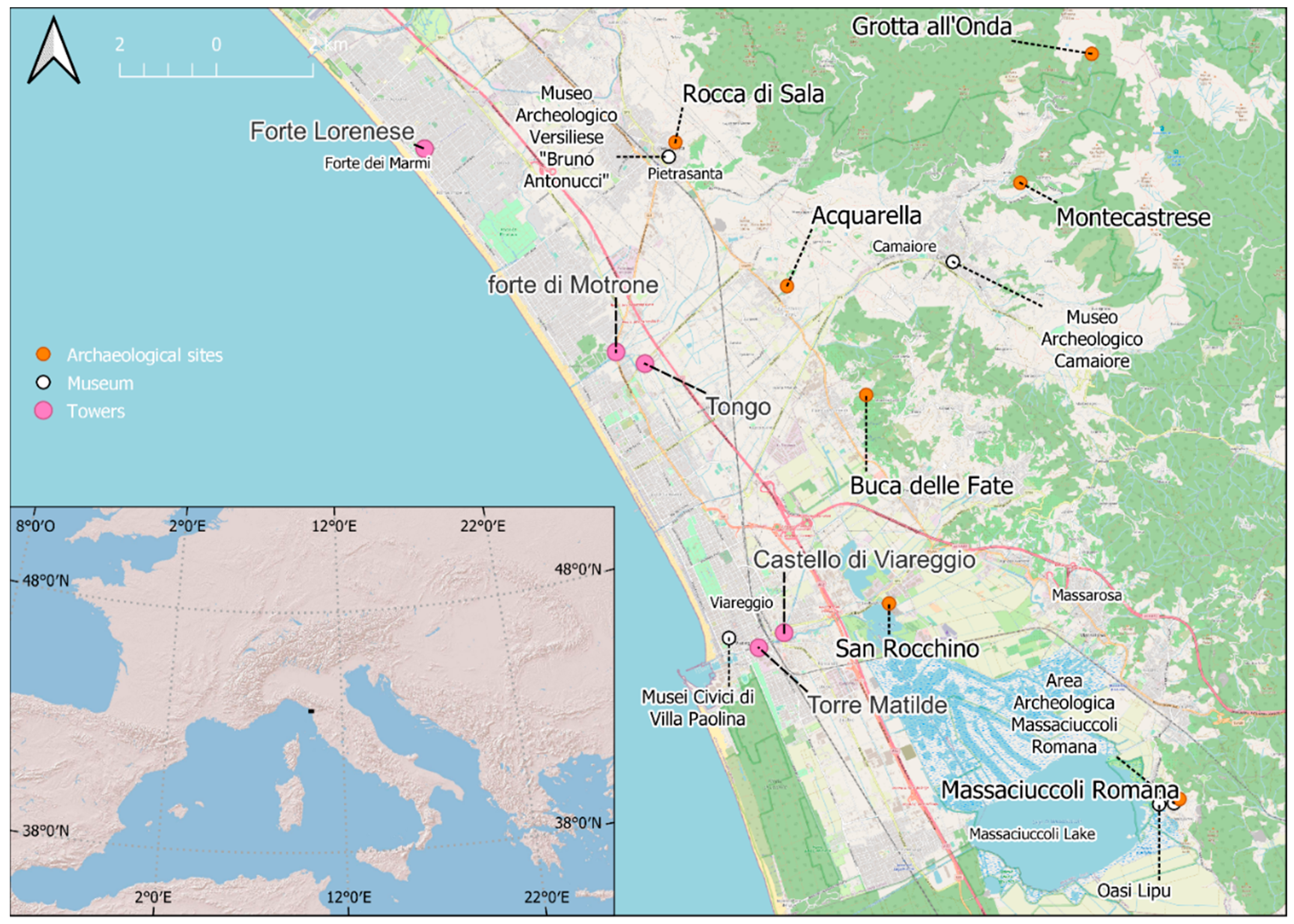
Since the Neolithic period, human presence has been confirmed by the findings of several artefacts, especially those of the site of Grotta all’Onda (
Figure 1) [
40].
During the Etruscan Age, the relevance of maritime commercial activity is testified by the settlement of San Rocchino (
Figure 1), located on the ancient coast. This site was continuously inhabited from the end of the eighth century B.C. to the third century B.C. and was located on the border of an ancient lagoon area, whose remains at present are identifiable in the Massaciuccoli Lake.
In the same period, the Migliarina site (
Figure 1), a productive and specialised settlement dating back to the end of the seventh century B.C., developed on the beach ridge, separating the lagoon from the sea and marking the coastline position of that time.
Moreover, the Acquarella site (
Figure 1) shows a remarkable continuity of human settlement from the Etruscan Archaic period to the early Middle Ages [
41]. The burial site found at Villa Mansi, close to Acquarella (
Figure 1), perhaps part of a necropolis, suggests the existence of a village and demonstrates the vitality of the area since the end of the seventh century B.C. [
42].
As for the Roman Age, weak traces of centuriation, as well as occasional discoveries on the beach ridge (
Figure 1), confirm the dense settlement of this area [
35]. The most important evidence of Roman times is the land roads attested in this area by ancient sources, maps, aerial photograph analyses and archaeological remains [
43]. An important road, which could be identified with the Aurelia/Aemilia Scauri, ran along the past coast, another one along the foothill. Both roads linked Pisa to Luni. A third road connecting the inland (i.e., Lucca) to the coast is documented in the Camaiore valley near the Acquarella site.
Montecastrese, the most populated castle of Versilia, was built between the 10th and 11th centuries and occupied an important position in the control of the territory (
Figure 1).
The Fortress of Motrone (
Figure 1), erected in
maris litore [
44], and the Old Castle of Viareggio (
Figure 1), built during the 12th century A.D., are important reference points for dating the shift of the coastal position during the Middle Ages. The construction in the 16th century of Tower Matilde in Viareggio and of Forte Lorenese in Forte dei Marmi (
Figure 1), in a more advanced position than the old fortress, demonstrates the gradual advance of the coastline.
3. Materials and Methods
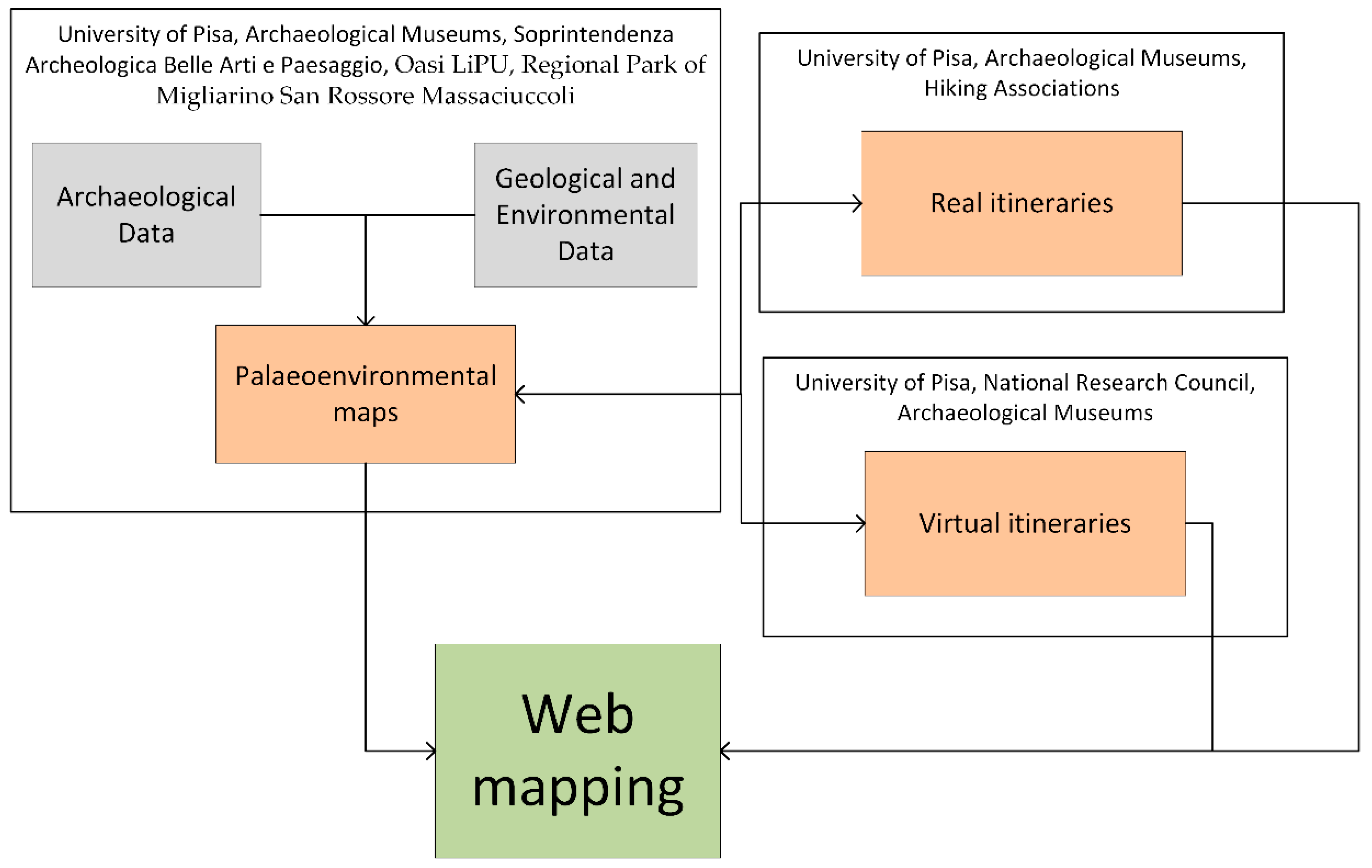
Our study aims to create a network among people with different jobs and competencies to intertwine different knowledge. This approach can help to create a synergy with researchers of different disciplines (e.g., geology, archaeology) and with people working on the territory, which could enhance the dissemination of cultural and natural heritage (archaeological museums, hiking associations, etc.). This holistic method would make it possible to complete and increase the great amount of knowledge already available in the territory and to put different subjects in synergy with one another.
Figure 2 shows the workflow and stakeholders involved in each section.
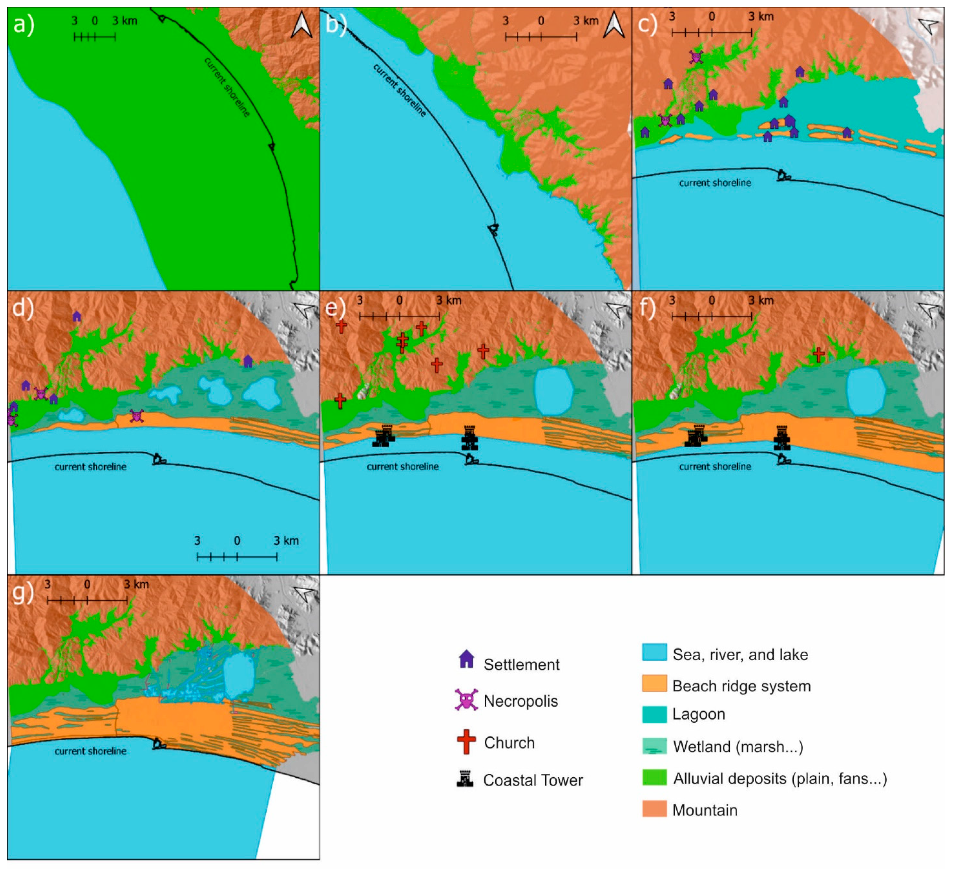
By the integration of different disciplines (geology, archaeology, biology), we reconstructed seven palaeoenvironmental maps describing seven chronological periods during which the area was settled. The periods investigated are the Last Glacial Maximum dated about 20,000 years B.P., the end of deglaciation about 7000 years B.P. and the Etruscan, Roman, Middle, Modern and Contemporary Ages. The palaeoenvironmental maps were derived from a review of bibliographic analyses [
31,
35,
36,
45] and from newly integrated data coming from core analysis, historical cartography, remote sensing analysis, morphological analyses and geomorphological surveys. The analyses were conducted in a GIS environment using the open-source software QGIS v3.x. In particular, according to [
46], we reconstructed the shoreline position at about 120 m below current sea level for the Last Glacial Maximum period and at about 8 m above current sea level for 7000 years B.C. [
47,
48]. In the maps, the estimation of the shoreline is based on the bathymetric measurement provided by the National Geoportal (
http://www.pcn.minambiente.it/mattm/ (accessed on 11 May 2022) and on the digital elevation model (DEM) provided by the Tuscany region, with a resolution of 10 m.
The maps related to the other chronological periods were obtained from the integration of geological with archaeological data. For example, we used subsoil data to identify the extension of the Massaciuccoli Lake over time, and geomorphological combined with subsoil and archaeological data to identify the beach ridges.
This study is based on the implementation of a PostgreSQL database with a PostGIS extension to store and standardise the data produced and used in this project. The PostgreSQL database is installed on a hosting virtual machine accessible with the HTTP protocol and usable for the consultation of the data by desktop software and web applications.
A web application was developed by using HTML, JavaScript, PHP languages and exclusively open-source libraries. The front end of the web application is responsive and operates on both desktop and mobile devices. The web application is characterised by a web GIS implemented by the open-source geospatial library ‘Open Layers’. The application is interfaced with the PostgreSQL database through the employment of the Geoserver application. The Open Layers library allows to load Web Feature Services (WFSs) and Web Map Services (WMSs) on a map by querying the Geoserver service. All layers are stylised according to the types of geometries and the database of the vectors. The web mapping allows to create an interaction between the user and the data of this research with two specific functionalities. The former consists of the possibility of clicking on one or more features to obtain some important information with the initialisation of a table on the interface. The visualised data can be texts, images or hyperlinks, and this allows to explain the geographic data and create an interaction between the user and the data of this research. The latter consists of the possibility of exporting the WFS in KML format, compatible with several GIS applications, such as desktop software (e.g., QGIS), web applications (e.g., Google Earth) and mobile apps for smartphones and smartwatches. This functionality makes it possible to apply the fundamentals of the open-data concept. The web application contains the palaeo maps, the virtual tours and the main natural and cultural heritage, together with several other layers that can help improve knowledge of the territory, as well as cultural and archaeological sites such as museums, environmental data, cartographies and aerial photos. In collaboration with some hiking associations, we identified nine itineraries that could link the different natural and cultural sites together, for example, an archaeological museum with its relative site and with other museums. The hiking associations will organise excursions so as to evaluate the real practicability of the itineraries in terms of distance and travel time. These itineraries are achieved in the PostgreSQL database with PostGIS extension using QGIS v3.x.
We have realised some information panels of the main archaeological and natural sites (such as Grotta all’Onda, LiPU, etc.) in both Italian and English. Some of these information panels have been installed along the real itineraries, and all the information panels are available for consultation through the web application.
The network between the sites and the museums is also incentivised with the development of virtual itineraries available for consultation on the web application.
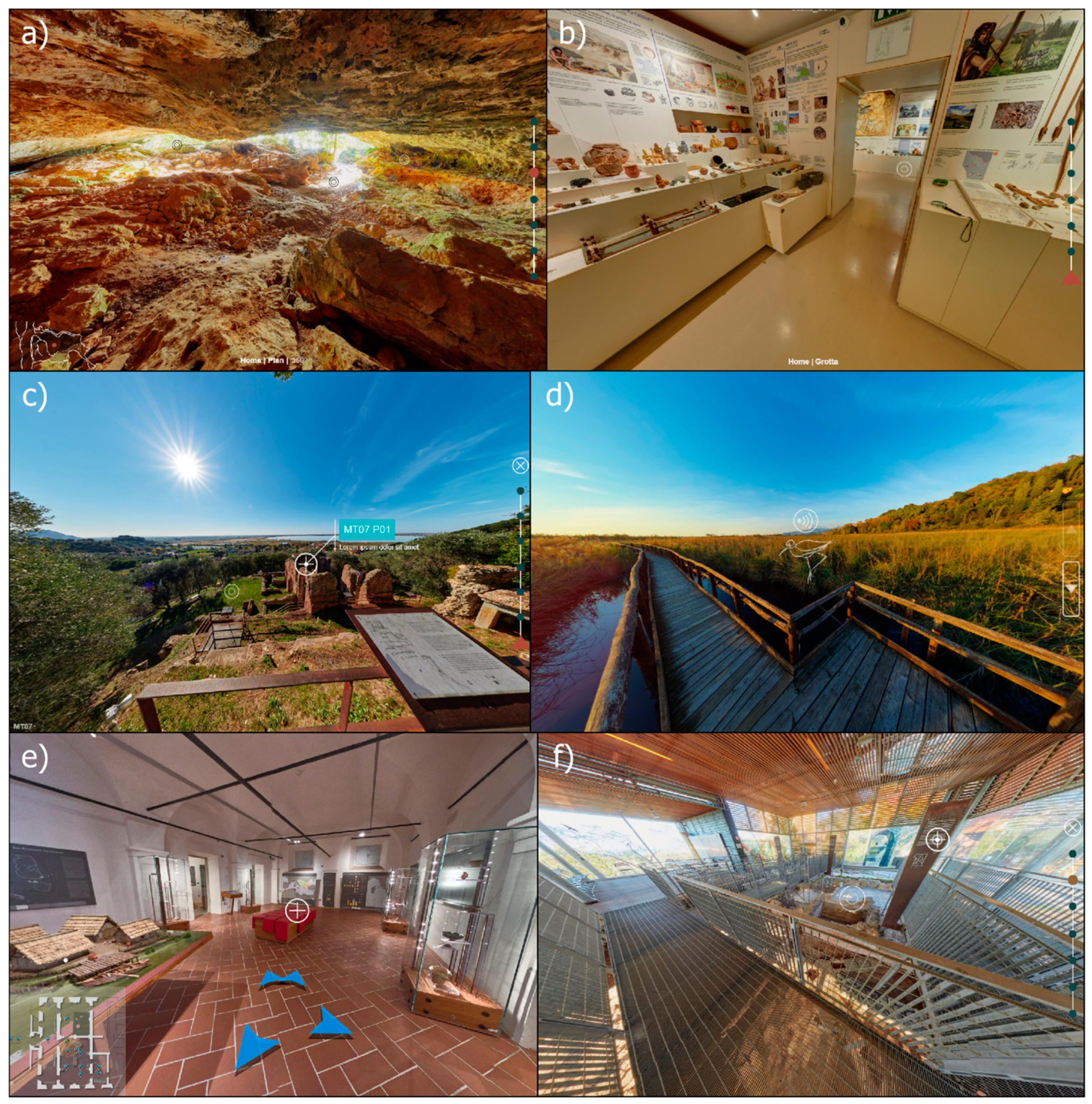
The elaboration of the virtual tours is based on photos taken in indoor and outdoor environments by using two photographic instruments: (i) Canon 550D APS-C camera with 16 mp, 8 mm fisheye optic, panoramic head with eight sequential photoshoot positions for a resolution of 12K; and (ii) six images Kandao ObsidianR 8K 360° camera with pixel-level synchronisation technology. The images are processed by the open-source software RawTherapee for calibration of the chromatic dominant and for luminosity control. We applied the high dynamic range (HDR) technique to the 360° photos by combining a minimum of three images acquired with different exposition values: normal (0 EV), overexposed (+2 EV) and underexposed (−2 EV). The HDR technique allows for the creation of environment images with illumination levels that are more extensive than those resulting from a single photograph: the shadows and highlights are made legible by bringing the brightness and contrast values of the image closer to the perception level of the human eye. The virtual tours are based on 360° images with the Krpano software, which uses XML language. XML language allows to manage the graphic layout, modality of fruition, hyperlinks, organisation of the various graphic elements, text contents, multimedia elements, photos, video and audio of the virtual tour.
4. Results
Figure 3 shows the palaeoenvironmental maps referred to as 20,000 years B.P. (a), 7000 years B.P. (b), Etruscan Age (c), Roman Age (d), Middle Ages (e), Modern Age (f) and Contemporary Age (g). The oldest period is characterised by a sea level lower than the current one by about 120 m [
46]. This corresponds to a shoreline position located about 20 km westwards of the current one. The area between the current shoreline and the Last Glacial Maximum shoreline was occupied by a wide coastal plain. With progressive deglaciation, we observe a sea level rise in the Versilia plain about 7000 years ago, when the sea reached the foothill of the mountains [
47]. In the Etruscan Age, owing to the sediment carried by the main rivers and reworked by coastal drift, the first beach ridge system formed, isolating coastal lagoons behind. Successively, we observe a progressive shift of the beach ridge system towards the west, which allowed the development of the coastal plain in its current conformation. In some periods, the Massaciuccoli Lagoon gradually became a coastal lake and wetland developed in its surroundings. Specifically, between the Roman and the Middle Ages, the Massaciuccoli Lake assumed a shape that was very similar to the current one. For each historical period,
Figure 3 reports the main human settlements and coastal towers located near the shore so as to be able to precisely identify the shift of the lake over time.
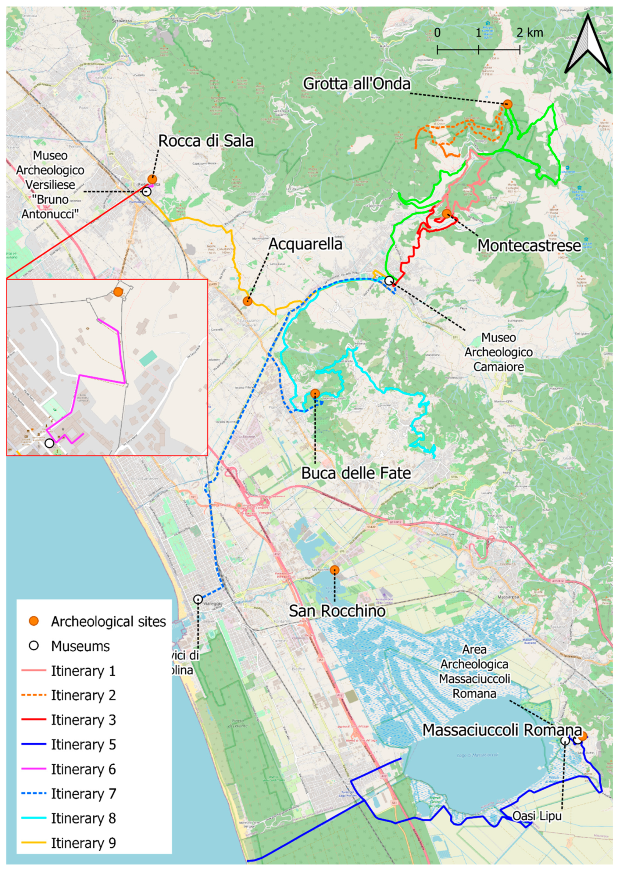
Figure 4 shows the nine natural and cultural itineraries identified in synergy with the local hiking associations. The first, second, third and fourth itineraries link the archaeological sites of Montecastrase and of Grotta all’Onda with the Camaiore Museum. These routes create a link between the archaeological sites and the Camaiore Archaeological Museum, where the findings and the documentation of these important sites are stored. The fifth itinerary links the archaeological area of the Roman Massaciuccoli with the Chiarone Nature Reserve situated within the Migliarino San Rossore Massaciuccoli Natural Park and then to the small village of Torre del Lago Puccini. A track around the lake starts from the small village and ends on a wide natural beach characterised by a system of well-preserved coastal dunes. The sixth itinerary is a little city route linking the Pietrasanta Archaeological Museum with the cultural site of Rocca di Sala. The seventh itinerary starts from the civic museums of Villa Paolina in Viareggio and ends at the Camaiore Archaeological Museum, going past the geoarchaeological site of Buca delle Fate. The eighth itinerary links the Museum of Camaiore with the geosite of Buca delle Fate through a mountain and hill track. Finally, the ninth itinerary links the museums of Pietrasanta and Camaiore through the Via Francigena route, the most famous of the medieval tracks.
The real itineraries are associated with the virtual tours, and some example images are reported in
Figure 5. The virtual tours are available for consultation at the link (
http://tlweb.it/pantarei/gis/ (accessed on 11 May 2022). The virtual itineraries are based on the creation of a link between the archaeological sites and the museums. We have also increased the multimedia and content information on the cultural and natural places that are worth visiting. With the same purposes as the natural tours, we have realised five virtual tours according to the different chronological periods analysed on the basis of the relative palaeogeographical maps. The five virtual tours are, specifically:
1. ‘Grotta all’Onda’, which shows the prehistoric environment in Versilia;
2. ‘Museo di Viareggio’, which allows to create a transition from the prehistoric to the historic period;
3. ‘Museo di Pietrasanta’, which regards the Etruscan Age in Versilia;
4. ‘Villa Mansio, Villa Venulei Apropriani’, which is referred to the Roman Age;
5. ‘Il paesaggio naturalistico attuale’, which describes the LIPU site and the importance of the wet areas and their preservation.
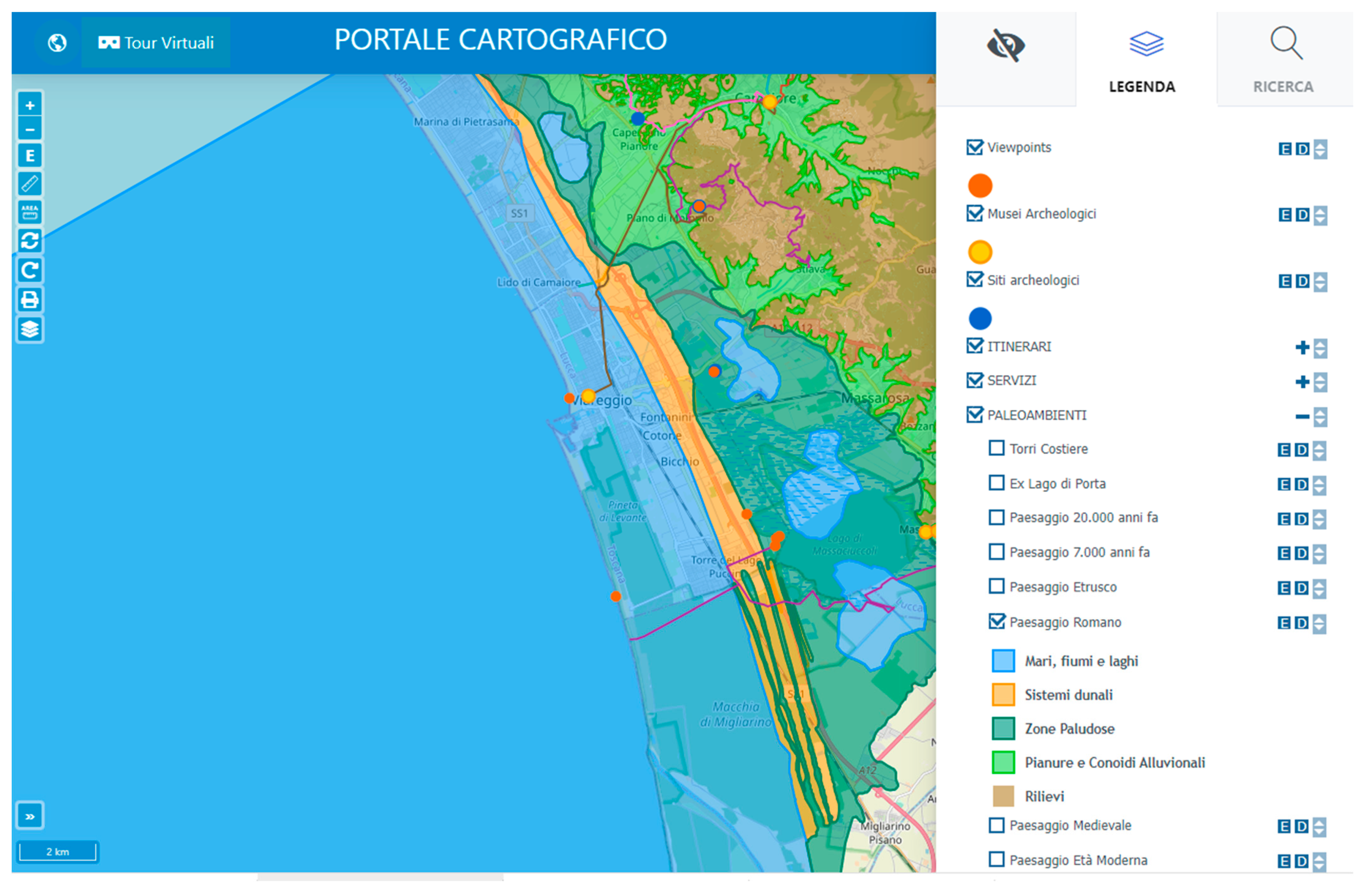
The web application interface is composed of a toolbar on the left, a map in the centre and a menu on the right (
Figure 6). The web application is available for consultation at the following link:
http://tlweb.it/pantarei/gis (accessed on 11 May 2010). The toolbar is provided with some functions for the navigation, selection and management of the map. In the menu, the layer tree view in the menu permits to manage the layers, with the possibility of making them visible, moving them, downloading the dataset and viewing the style of the layers. By using the web application, it is possible to visit both the real and the virtual itineraries and to gain territorial as well as cultural information.
5. Discussion and Conclusions
The use of web mapping for disclosure of territorial information and the enhancement of cultural and natural heritage was a valid instrument in agreement with several previous studies (i.e., [
10,
21,
22,
23,
24,
25]). The web mapping, usable by different devices (PC desktop, smartphone, etc.), can provide visibility to the territory, and this is accentuated with the creation of virtual itineraries [
24,
25,
26,
27,
28].
This study takes a step forward compared to others by creating a triple link between real and virtual tours and making them available on a platform that allows you to consult geographic information but also other information such as information panels, tabulated data, images, etc.
The Versilia plain witnesses the history of a long human–environment interaction dating back to the Prehistoric Age. This history can still be read through the cultural and natural assets characterising the area, which tell the story of both environmental evolution and the history of settlement.
Thanks to a strong integration of data from different sources, it is possible to describe a story that can intrigue the visitor, going beyond administrative and cultural limitations.
Visitors receive information about the landscape during prehistoric times, the location of the sites that have returned prehistoric finds and the museums where these findings can be observed. Similarly, it is possible to accompany the visitors by describing the discovery of the Etruscan landscape and of the museums closely related to the history of the Etruscan period. The same can be applied to the Roman period.
The visit to the LIPU oasis shows a picture of the current environment and allows reflections on the most likely future evolutions.
The creation of both natural and virtual itineraries can help to easily connect the different historical periods in an overall evolutionary framework. Broad sharing of data allows for the dissemination of knowledge and increased awareness among both tourists and local communities.
Access to these data (through web mapping and the virtual tour) increases the visibility of a territory that, although very close to areas of great tourist flow, is actually excluded. The availability of free and open-source informatic instruments makes it possible to employ replicable instruments and methodologies in other contexts as well. The involvement of all stakeholders right from the design stages has led to a growth in synergies among the different bodies involved in the project. This collaborative effort and multidisciplinary approach have contributed to the dissemination of knowledge and to the achievement of more holistic results.
The future use of the platform and future integrations of data and functionalities will make it possible to refine the study and provide an increasingly advanced solution for the dissemination of cultural and natural heritage.
This study has proved useful for the creation of IT tools that potentially allow the dissemination of knowledge of the environmental and cultural heritage contained in the territory. However, real enhancement of the territory can only be achieved through the willingness and commitment of the managing bodies to the use and advertising of these tools.
Author Contributions
Conceptualisation, Monica Bini and Valerio Noti; methodology, Monica Bini, Marco Luppichini, Valerio Noti and Danilo Pavone.; software, Marco Luppichini and Danilo Pavone; validation, Monica Bini, Marco Luppichini, Valerio Noti, Danilo Pavone, Marzia Bonato, Francesco Ghizzani Marcìa, Stefano Genovesi, Francesca Lemmi, Lisa Rosselli, Neva Chiarenza, Marta Colombo, Giulia Picchi and Andrea Fontanelli.; resources, Monica Bini; writing—original draft preparation, Monica Bini and Marco Luppichini.; writing—review and editing, Monica Bini, Marco Luppichini, Valerio Noti, Danilo Pavone, Marzia Bonato, Francesco Ghizzani Marcìa, Stefano Genovesi, Francesca Lemmi, Lisa Rosselli, Neva Chiarenza, Marta Colombo, Giulia Picchi and Andrea Fontanelli.; project administration, Monica Bini.; funding acquisition, Monica Bini. All authors have read and agreed to the published version of the manuscript.
Funding
This research was funded by project no. 249792, “Dalla Preistoria all’Antropocene: Nuove Tecnologie per la valorizzazione dell’eredità culturale della Versilia (PANTAREI)” Tuscany region (call POR FSE 2014- 2020, Resp. M. Bini) and by project “Cambiamenti globali e impatti locali: conoscenza e consapevolezza per uno sviluppo sostenibile della pianura Apuo-versiliese” Fondazione Cassa di Risparmio di Lucca (call 2018 years 2019-2022- Resp. M. Bini).
Data Availability Statement
Acknowledgments
We thank the various excursion associations that have allowed their support in the identification and dissemination of the real itineraries. We thank all the public bodies involved for their support and dissemination of the project.
Conflicts of Interest
The authors declare no conflict of interest.
References
- World Tourism Organization UNWTO. Tourism Highlights; World Tourism Organization UNWTO: Madrid, Spain, 2018. [Google Scholar]
- World Tourism Organization UNWTO. Tourism Highlights; World Tourism Organization UNWTO: Madrid, Spain, 2011. [Google Scholar]
- Koens, K.; Postma, A.; Papp, B. Is Overtourism Overused? Understanding the Impact of Tourism in a City Context. Sustainability 2018, 10, 4384. [Google Scholar] [CrossRef]
- Butler, R.W. Tourism, Environment, and Sustainable Development. Environ. Conserv. 1991, 18, 201–209. [Google Scholar] [CrossRef]
- UNEP; UNWTO. Making Tourism More Sustainable—A Guide for Policy Makers; UNWTO Publications: Madrid, Spain, 2005. [Google Scholar]
- Ingaldi, M.; Dziuba, S.T. Sustainable Tourism: Tourists’ Behaviour and Their Impact on the Place Visited. Vis. Sustain. 2021, 17, 8–38. [Google Scholar] [CrossRef]
- Petrella, A.; Torrini, R.; Barone, G.; Beretta, E.; Breda, E.; Cappariello, R.; Ciaccio, G.; Conti, L.; David, F.; Degasperi, P.; et al. Turismo in Italia: Numeri e Potenziale Di Sviluppo; Banca d’Italia: Rome, Italy, 2019. [Google Scholar]
- Viciani, D.; Dell’Olmo, L.; Vicenti, C.; Lastrucci, L. Natura 2000 Protected Habitats, Massaciuccoli Lake (Northern Tuscany, Italy). J. Maps 2017, 13, 219–226. [Google Scholar] [CrossRef]
- Kraak, J.-M.; Brown, A. Web Cartography; CRC Press: Boca Raton, FL, USA, 2003; ISBN 0429182104. [Google Scholar]
- Costantino, D.; Angelini, M.G.; Alfio, V.S.; Claveri, M.; Settembrini, F. Implementation of a System WebGIS Open-Source for the Protection and Sustainable Management of Rural Heritage. Appl. Geomat. 2020, 12, 41–54. [Google Scholar] [CrossRef]
- de Castro, A.F.; Amaro, V.E.; Grigio, A.M.; Cavalcante, R.G. Modeling and Development of a WebGIS for Environmental Monitoring of Coastal Areas That Are Influenced by the Oil Industry. J. Coast. Res. 2011, SI64, 1643–1647. [Google Scholar]
- Tang, W.; Selwood, J. Connecting Our World: GIS Web Services; ESRI, Inc.: Redlands, CA, USA, 2003; ISBN 1589480759. [Google Scholar]
- Opdam, P. Learning Science from Practice. Landsc. Ecol. 2010, 25, 821–823. [Google Scholar] [CrossRef]
- Lopes, S.I.; Moreira, P.M.; Cruz, A.M.; Martins, P.; Pereira, F.; Curado, A. RnMonitor: A WebGIS-Based Platform for Expedite in Situ Deployment of IoT Edge Devices and Effective Radon Risk Management. In Proceedings of the 2019 IEEE International Smart Cities Conference (ISC2), Casablanca, Morocco, 14–17 October 2019; IEEE: Piscataway, NJ, USA, 2019; pp. 451–457. [Google Scholar]
- Pan, S.; Wang, K.; Wang, L.; Wang, Z.; Han, Y. Risk Assessment System Based on WebGIS for Heavy Metal Pollution in Farmland Soils in China. Sustainability 2017, 9, 1846. [Google Scholar] [CrossRef]
- Howell, R.G.; Petersen, S.L.; Balzotti, C.S.; Rogers, P.C.; Jackson, M.W.; Hedrich, A.E. Using Webgis to Develop a Spatial Bibliography for Organizing, Mapping, and Disseminating Research Information: A Case Study of Quaking Aspen. Rangelands 2019, 41, 244–247. [Google Scholar] [CrossRef]
- Seng, B.; Liang, H.; Zhao, Y.; Tang, Y. Design and Implementation of Visualization System for Wastewater Treatment in Dianchi Lake Based on WebGIS. In Proceedings of the E3S Web of Conferences, Shanghai, China, 16–18 August 2019; EDP Sciences: Les Ulis, France, 2019; Volume 118, p. 04032. [Google Scholar]
- Luo, K.; Zhang, T.; Liu, Y. Design and Implementation of the Water Environment Monitoring and Management System Based on WebGIS for the Four-Lake Basin of Hubei Province. In Proceedings of the E3S Web of Conferences, Hefei, China, 1–3 November 2019; EDP Sciences: Les Ulis, France, 2019; Volume 136, p. 06036. [Google Scholar]
- Villani, G.; Nanni, S.; Tomei, F.; Pasetti, S.; Mangiaracina, R.; Agnetti, A.; Leoni, P.; Folegani, M.; Mazzini, G.; Botarelli, L. The RainBO Platform for Enhancing Urban Resilience to Floods: An Efficient Tool for Planning and Emergency Phases. Climate 2019, 7, 145. [Google Scholar] [CrossRef]
- Santoso, M.I.; Gumelar, R.G.; Irawan, B. Development of the WebGIS Application for Transport Infrastructure Management in the City of Serang. In Proceedings of the IOP Conference Series: Materials Science and Engineering, Bali, Indonesia, 7–8 August 2019; IOP Publishing: Bristol, UK, 2019; Volume 673, p. 012072. [Google Scholar]
- Tommasi, A.; Cefalo, R.; Zardini, F.; Nicolaucig, M. Using Webgis and Cloud Tools to Promote Cultural Heritage Dissemination: The Historic up Project. In Proceedings of the International Archives of the Photogrammetry, Remote Sensing and Spatial Information Sciences—ISPRS Archives, Florence, Italy, 22–24 May 2017; International Society for Photogrammetry and Remote Sensing: Christian Heipke, Germany, 2017; Volume 42, pp. 663–668. [Google Scholar]
- Suma, A.; de Cosmo, P. Geodiv Interface: An Open Source Tool For Management And Promotion Of The Geodiversity Of Sirra De Grazalema Natural Park (Andalusia, Spain). GeoJournal Tour. Geosites 2011, 8, 309–318. [Google Scholar]
- Lerario, A.; Maiellaro, N.; Zonno, M. Remote Fruition of Architectures: R&D and Training Experiences. In Proceedings of the 2010 Second International Conferences on Advances in Multimedia, Washington, DC, USA, 13–19 June 2010; pp. 49–54. [Google Scholar]
- Santos, C.A.D.J.; Campos, A.C.; Rodrigues, L.P. GIS and Touristic Itineraries. The Case of São Cristóvão, Sergipe, Brazil. Cad. De Geogr. 2019, 39, 29–39. [Google Scholar] [CrossRef]
- Cayla, N.; Hoblea, F.; Gasquet, D. Place de La Géomorphologie Dans l’offre Géotouristique de l’arc Alpin: Du Réel Au Virtuel. Géomorphosites 2009, 65–71. [Google Scholar]
- Medyńska-Gulij, B.; Zagata, K. Experts and Gamers on Immersion into Reconstructed Strongholds. ISPRS Int. J. Geo-Inf. 2020, 9, 655. [Google Scholar] [CrossRef]
- Sâvulescu, I.; Mihai, B. Mapping Forest Landscape Change in Iezer Mountains, Romanian Carpathians. AGIS Approach Based on Cartographic Heritage, Forestry Data and Remote Sensing Imagery. J. Maps 2011, 7, 429–446. [Google Scholar] [CrossRef]
- Weng, Y.-H.; Sun, F.-S.; Grigsby, J.D. GeoTools: An Android Phone Application in Geology. Comput. Geosci. 2012, 44, 24–30. [Google Scholar] [CrossRef]
- Bailey, J.E.; Chen, A. The Role of Virtual Globes in Geoscience; Elsevier Science Publishers: Amsterdam, The Netherlands, 2011. [Google Scholar]
- Dias, E.; Rhin, C.; Haller, R.; Scholten, H. Adding Value and Improving Processes Using Location-Based Services in Protected Areas: The WebPark Experience. E-Environ. Prog. Chall. Spec. Ed. e-Environ. Inst. Politécnico Nac. Mex. Mex. City 2004, 291–302. [Google Scholar]
- Baroni, C.; Pieruccini, P.; Bini, M.; Coltorti, M.; Fantozzi, P.L.; Guidobaldi, G.; Nannini, D.; Ribolini, A.; Salvatore, M.C. Geomorphological and Neotectonic Map of the Apuan Alps (Tuscany, Italy). Geogr. Fis. E Din. Quat. 2015, 38, 201–227. [Google Scholar]
- Molli, G.; Giorgetti, G.; Meccheri, M. Tectono-Metamorphic Evolution of the Alpi Apuane Metamorphic Complex: New Data and Constraints for Geodynamic Models. Boll. Della Soc. Geol. Ital. 2002, 1, 789–800. [Google Scholar]
- Carmignani, L.; Kligfield, R. Crustal Extension in the Northern Apennines: The Transition from Compression to Extension in the Alpi Apuane Core Complex. Tectonics 1990, 9, 1275–1303. [Google Scholar] [CrossRef]
- Regione Toscana Piano Di Indirizzo Territoriale Con Valenza Di Piano Paesaggistico, Ambito Versilia e Costa Apuana. 2015. Available online: https://www.regione.toscana.it/-/piano-di-indirizzo-territoriale-con-valenza-di-piano-paesaggistico (accessed on 30 April 2022).
- Bini, M.; Sarti, G.; da Prato, S.; Fabiani, F.; Paribeni, E.; Baroni, C. Geoarcheological Evidences of Changes in the Coastline Progradation Rate of the Versilia Coastal Plain between Camaiore AndViareggio (Tuscany, Italy): Possible Relationships with Late Holocene High-Frequency Transgressive Regressive Cycles. Il Quat. Ital. J. Quat. Sci. 2009, 22, 257–266. [Google Scholar]
- Bini, M.; Baroni, C.; Ribolini, A. Geoarchaeology as a Tool for Reconstructing the Evolution of the Apuo-Versilian Plain (NW Italy). Geogr. Fis. E Din. Quat. 2013, 36, 215–224. [Google Scholar] [CrossRef]
- Federici, P.R. L’ex Lago Di Porta in Versilia (Toscana): La Storia Di Una Irresistibile Pressione Ambientale. Mem. Soc. Geogr. Ital. 1998, 55, 397–414. [Google Scholar]
- Federici, P.R. The Versilian Transgression of the Versilia Area (Tuscany, Italy) in the Light of Drillings and Radiometric Data. Mem. Della Soc. Geol. Ital. 1993, 49, 217–225. [Google Scholar]
- D’Amato Avanzi, G.; Giannecchini, R. Eventi Alluvionali e Fenomeni Franosi Nelle Alpi Apuane (Toscana): Primi Risultati Di Un’indagine Retrospettiva Nel Bacino Del Fiume Versilia. Riv. Geogr. Ital. 2003, 110, 527–559. [Google Scholar]
- Berton, A.; Bonato, M.; Campetti, S.; Fabbri, P.F.; Mallegni, F.; Perrini, L. Nuove Indagini Del Deposito Preistorico Di Grotta All’Onda; Camaiore (LU): Toscana, Italy, 2006. [Google Scholar]
- Fabiani, F.; Rovai, E.P. Il Frantoio Romano Dell’Acquarella; Felici Editore: Pisa, Italy; ISBN 9788860195920.
- Ciampoltrini Villa Mansi (Camaiore). In Etruscorum Ante Quam Ligurum. La Versilia tra VII e III Secolo a.C.; Paribeni (Ed.) Bandecchi e Vivaldi: Pontedera, Italy, 1990; pp. 119–121. [Google Scholar]
- Fabiani, F. "… Stratam Antiquam Que Est per Palude Set Boscos…". Viabilità Romana Tra Pisa e Luni; Edizioni Plus: Pisa, Italy, 2006. [Google Scholar]
- Giannotti, S. Pietrasanta (LU). Controllo Archeologico a Motrone. Not. Della Soprintend. Per I Beni Archeol. Della Toscana 2006, 2, 23–25. [Google Scholar]
- Pasquinucci, M.; Menchelli, S.; Mazzanti, R.; Marchisio, M.; D’Onofrio, L. Coastal Archaeology in North Etruria [North Coastal Etruria. Géomorphologie, Archaeological, Archive, Magnetometric and Geoelectrical Researches. Rev. D’archéométrie 2001, 25, 187–201. [Google Scholar] [CrossRef]
- Lambeck, K.; Purcell, A. Sea-Level Change in the Mediterranean Sea since the LGM: Model Predictions for Tectonically Stable Areas. Quat. Sci. Rev. 2005, 24, 1969–1988. [Google Scholar] [CrossRef]
- Sestini, A. Un’antica Ripa Marina Nella Pianura Costiera Apuana. Mem. Della Soc. Toscana Di Sci. Nat. 1950, 57, 1–6. [Google Scholar]
- Vacchi, M.; Marriner, N.; Morhange, C.; Spada, G.; Fontana, A.; Rovere, A. Multiproxy Assessment of Holocene Relative Sea-Level Changes in the Western Mediterranean: Sea-Level Variability and Improvements in the Definition of the Isostatic Signal. Earth-Sci. Rev. 2016, 155, 172–197. [Google Scholar] [CrossRef] [Green Version]
| Publisher’s Note: MDPI stays neutral with regard to jurisdictional claims in published maps and institutional affiliations. |
© 2022 by the authors. Licensee MDPI, Basel, Switzerland. This article is an open access article distributed under the terms and conditions of the Creative Commons Attribution (CC BY) license (https://creativecommons.org/licenses/by/4.0/).


 ,
, 


