The Implementation of Spatial Planning Objects in a 3D Cadastral Model


Department of Geomatics, AGH University of Science and Technology, 30-059 Cracow, Poland
*
Author to whom correspondence should be addressed.
ISPRS Int. J. Geo-Inf. 2018, 7(4), 153; https://0-doi-org.brum.beds.ac.uk/10.3390/ijgi7040153
Submission received: 8 March 2018
/
Revised: 28 March 2018
/
Accepted: 15 April 2018
/
Published: 18 April 2018
(This article belongs to the Special Issue Productive, Livable and Accessible Cities—The Role of 3D City Models)
Abstract
:The paper concerns spatial planning in Poland and its connection with the cadastre. The Polish spatial planning system defines the set of colours, lines, hatches, etc. destined for the preparations of spatial plans, though this has so far not been followed by a spatial planning model or application schema. The aim of this paper is to create a preliminary concept of the unified modelling language (UML) schema of database integrating 3D cadastre and 3D spatial planning. The authors initially define five unified modelling language classes representing spatial planning objects (four representing spatial objects and one a dictionary list). As spatial planning and cadastres are very strongly connected, these classes are implemented into a cadastral model that had been earlier enriched with 3D classes. The final results of this research are UML diagrams based on the Polish cadastral model as defined earlier in legal regulations. They comprise original cadastral model classes, 3D cadastral objects added in earlier research work, classes representing spatial planning objects and the relationships among them. Such a solution better connects cadastre and spatial planning on a structural level and introduces 3D elements into spatial planning which has basically been done in two dimensions.
1. Introduction
The land and building cadastre is a very important element of the spatial information infrastructure, on the basis of which various analyses can be carried out [1]. It is assumed that in the future, the property cadastre database will contain sufficient data to carry out procedures aimed at sustainable development [2].
The attempts to ensure the sustainable and healthy development of the human environment should be preceded by the introduction of systems preventing its improper management [3]. Imagining our future is a collective responsibility of communities, planners and decision makers, and therefore visualization techniques are becoming an important tool in spatial planning [4]. The analyses performed in this way are more complete if they can be carried out with the use of 3D technology [5]. Three-dimensional visualization may facilitate both insight into complex real estate structures and the arrangement of specific objects in space [6]. However, a clearly defined concept for integrating cadastre and three-dimensional urban models to use 3D analyses to support urban planning and policy decision making is missing [7]. This issue is difficult to find, both in world literature and in normative acts (both international and national).
At present, the 3D cadastre (or more generally 3D oriented sciences) and spatial planning seem to be two different worlds. An attempt to put them together was made in 2016 in Delft [8]. At the moment, it is very difficult to judge whether or not it has become successful. Nevertheless, it seems that there is still quite a lot to do to “introduce” 3D concepts to spatial planning.
This topic is worth addressing, for example, due to actions related to the protection of cultural heritage [9], as well as the landscape and natural environment [10] and the using of underground space [11].
There have been various research studies that have tried to implement new achievements concerning 3D into spatial planning. Some of them concern merging 3D visualization concepts with urban planning. The concept of applying 3D augmented reality which can help urban planning is presented in [12]. Research on visibility analysis, which can have a potentially positive impact on urban planning, is described in [13]. In research [14], the virtual globe-based 3D visualization framework can act in favour of publicizing urban planning information.
The application of web-based 3D tools in support of urban planning is becoming quite popular. Although the majority of plans are still produced in 2D, there is a growing trend towards 3D [15]. According to [16], there are benefits of 3D urban planning, although some 3D attributes are more helpful in the planning process than others. It is also worth noting that urban planning can be an important component of concept 3D urban ecosystem services [17].
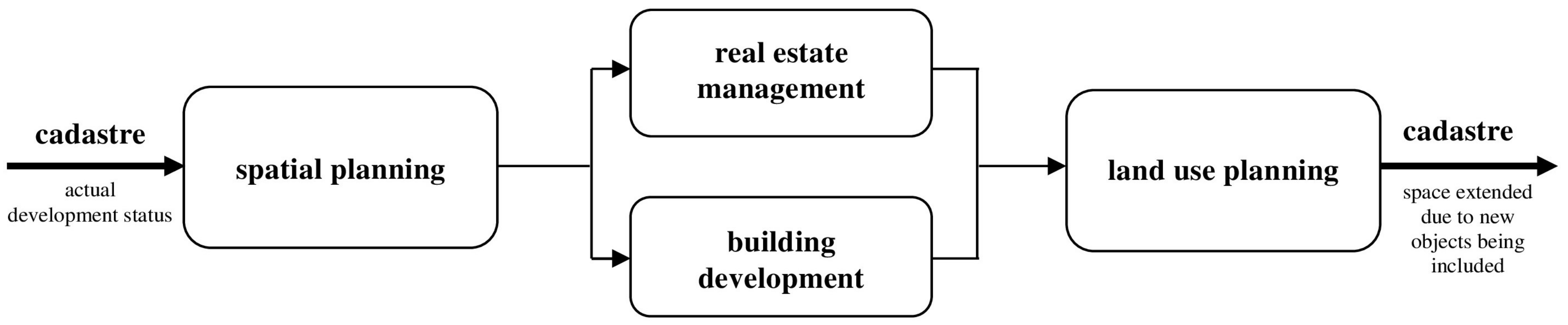
The role of spatial planning in land administration was also noted when developing the land administration domain model [18]. This concerns both 2D and 3D situations. It was also noticed that the 3D cadastre additionally concerns spatial/urban planning issues [19]. The authors’ idea was to propose the inclusion of spatial planning elements in the cadastral model. The paper was prepared in order to create a preliminary concept of the UML schema of a database integrating 3D real estate cadastre data and 3D spatial planning. Such integration is possible due to the relationship between cadastre and spatial planning (Figure 1).
The term cadastre covers a system ensuring the collection, updating and publication of information on real estates [21]. It is increasingly stated in worldwide literature that the data describing real estates collected in cadastral databases should be three-dimensional [22]. This would make it easy to visualize the complicated real estate legal situations and enable the registration of full information on the geometry of buildings and premises.
Spatial planning, in turn, is a set of system actions that concern the future states of space [20]. They are taken up by the relevant public administration agencies on the basis of the existing state of space (described, inter alia, in the real estate cadastre). They lead to the area’s land use determination for specific purposes and to the establishing of the principles of their development and build-up [23]. Spatial planning provides an answer to the question of where the planned objects are going to be located. In future, it will change the space and create new spatial development (i.e., new cadastral objects). These objects are implemented in the real estate management (i.e., division, merging and division, expropriation) and construction (i.e., development) processes.
The links between cadastre and spatial planning described above make it natural to integrate the data they contain. This means that some spatial planning information should also be recorded as 3D objects, which is certainly necessary for areas that are subject to various types of development restrictions. Such limitations may result from the provisions of legal regulations ordering other areas of life (e.g., environmental protection, protection of agricultural land, landscape protection, protection of monuments, natural hazards, etc.).
2. Methodology and Materials
As part of the research, the analysis of selected elements of the Polish real estate cadastre and the Polish spatial planning system were carried out. Then, an attempt to integrate and standardize them in order to harmonise the proposed solutions with global ones was made.
The analyses focused on the provisions related to the creation of a database containing information on the actual state of land, buildings and premises, as well as the one containing information on the real estate designation.
The conceptual work was based on existing national legal bases. For the cadastre, these are geodetic and cartographic law [21] and the Regulation on the Land and Building Cadastre [24]. For spatial planning, these are the Act on Spatial Planning and Development [21] and the Regulation on the Required Scope of the Project of Local Spatial Plans [25].
As Poland’s real estate cadastre and spatial planning documents are created in a two-dimensional space, the research has been extended to include the analysis of worldwide literature concerning 3D cadastre and 3D planning. It has helped to develop the initial assumptions for the creation of a 3D cadastre application schema containing spatial planning information.
In order to adapt the design of the database to world standards, its initial version was confronted with the provisions of ISO 19152, “Geographic Information—Land Administration Domain Model (LADM)” [26]. Diagrams containing spatial planning classes and cadastral model classes that are relevant to spatial planning have been prepared applying unified modelling language and are described in this publication in detail.
3. The Cadastre in Poland
In Poland, the following two systems contain information concerning land: the land registry and the cadastre. The land registry in Poland contains information concerning legal objects (land parcels, buildings and apartment units). This information generally concerns description and designation, rights, restrictions and responsibilities (including mortgages). Cadastral data mainly consists of spatial descriptions, attributes, values and the corresponding official documents of legal objects. Objects included in the cadastre are land parcels and buildings or premises (apartment units) that are separately owned estates. The most common cadastral objects are land parcels. The bases of cadastre in Poland are defined by geodetic and cartographic law [21]. Details regulating the contents and operations of the cadastre are defined by the Regulation of the Ministry of Regional Development and Buildings dated the 29 March 2001 [24].
The conceptual model of Polish cadastral data is defined within the Regulation from the 29th of November, 2013 [27]. It consists of UML application schema, a catalogue of objects and geographic markup language (GML) application schema. The UML application schema of cadastral data is defined by applying unified modelling language, which is then transferred to the geographic markup language listing. The catalogue of objects contains definitions and descriptions of the types of objects presented in the application model, and their attributes and interrelations between them, occurring in one or more diagrams. The Polish cadastral model consists of the following sixteen diagrams [28] (based on [27]):
- General Object;
- Inheritance;
- Cadast Complex Cadast Section;
- Parcel Contour of Soil Quality Valuation in Parcel;
- Building Premises;
- Object Data Glossaries;
- Party;
- Parties Glossaries;
- Register Units;
- Shares;
- Register Units Parties Grouping;
- Rights to Properties Glossaries;
- Address;
- Boundary Point;
- Lease;
- Legal Basis.
The diagrams describing the cadastral model are grouped in the following eight thematic packages [28] (based on [27]):
- General Object;
- Objects;
- Parties;
- Rights to Properties;
- Address;
- Boundary Point;
- Lease;
- Legal Basis.
These diagrams cover extensive aspects of land administration concerning, e.g., property registration, rights registration and land use aspects. The land use issues concern soil quality valuation as well as intended and current land use.
4. Spatial Planning in Poland
Currently, the basis of spatial planning in Poland is a law enacted in 2003 [23]. Spatial planning is implemented at the national, provincial (regional) and municipal (local) levels [29]. The county level, placed between provincial (regional) and municipal (local) levels of Poland’s territorial division, is omitted in the spatial planning process [30]. The most important level for spatial planning is the municipal one. The planning documents at this level are the most detailed and therefore have a decisive influence on the immediate human environment [20].
Local planning documents detail the conditions and directions of the spatial development of the municipality (obligatory for the whole municipality) and the local spatial development plan. Unfortunately, since the creation of local spatial plans is not mandatory, and the provisions contained therein are binding in case of issuing various administrative decisions, Polish law allows for the issuance of a document which may replace the local plan in the absence of this. This is a so-called decision regarding urban land and its development [31].
All Polish spatial planning documents have, of course, a graphical and descriptive (textual) part. The graphical part features a proper map and is based on cadastral data and land development information. Its contents mainly include the boundaries of areas with different designations and the boundaries of various types of protection zones. The textual part is in turn a set of conditions that must be met by objects planned to be built in particular areas.
In Polish spatial planning regulations, there is, so far, no standardization for symbols used in planning documents. All of the above-mentioned spatial plans use similar, though not strictly defined, colour markings, lines, symbols, and letters. Unfortunately, even in the documents developed for the same municipality, they are heterogeneous: for example, the local spatial development plans for the city of Cracow. Within the administrative boundaries of Cracow, there are 152 local spatial development plans (as of 28 July 2017). The graphical attachment to each of them was developed using commonly understood colours, lines and symbols. This does not mean, however, that they are identical in all documents. For example, colour shades or line thicknesses may vary slightly. This results in the fact that, without a legend, the plan could be mistakenly interpreted.
Legislative work is now underway on the so-called urban and construction code. According to the project submitted for consultation, the code will strongly influence the spatial planning system in Poland. According to the future code, planning or the updating of planning documents will not be possible without the creation of a planning database that is included in the infrastructure for spatial information. This means that executive rules will have to be created, according to which such bases will be run. The planned result will be the unification of planning work carried out throughout the whole country.
Pilot work on the harmonization of spatial data sets for spatial management in Poland was carried out in 2014–2015. It covered the local spatial development plans for chosen municipalities [32].
An obvious consequence of the pilot project was the decision to elaborate the standard for spatial planning databases. Works concerning this standard are in progress. The aim of this task is to define the scope and principles of the collection of planning information taking into account the specifics of the Polish spatial planning system and the importance of these databases for spatial information infrastructure. The proposed standards will be the starting point for legislative work for the comprehensive regulation of the development and construction processes in the urban and construction code. These standards are to comply with the INSPIRE directive [33] and its implementing regulations.
5. Introducing the 3D Concept to Spatial Planning
Researchers around the world are increasingly investigating the possibility of introducing 3D spatial planning and connecting it with 3D cadastre [8]. A three-dimensional view on planning space is associated with changes that have occurred as a result of ubiquitous computerisation and digitalization and the impact this has had on building design methods.
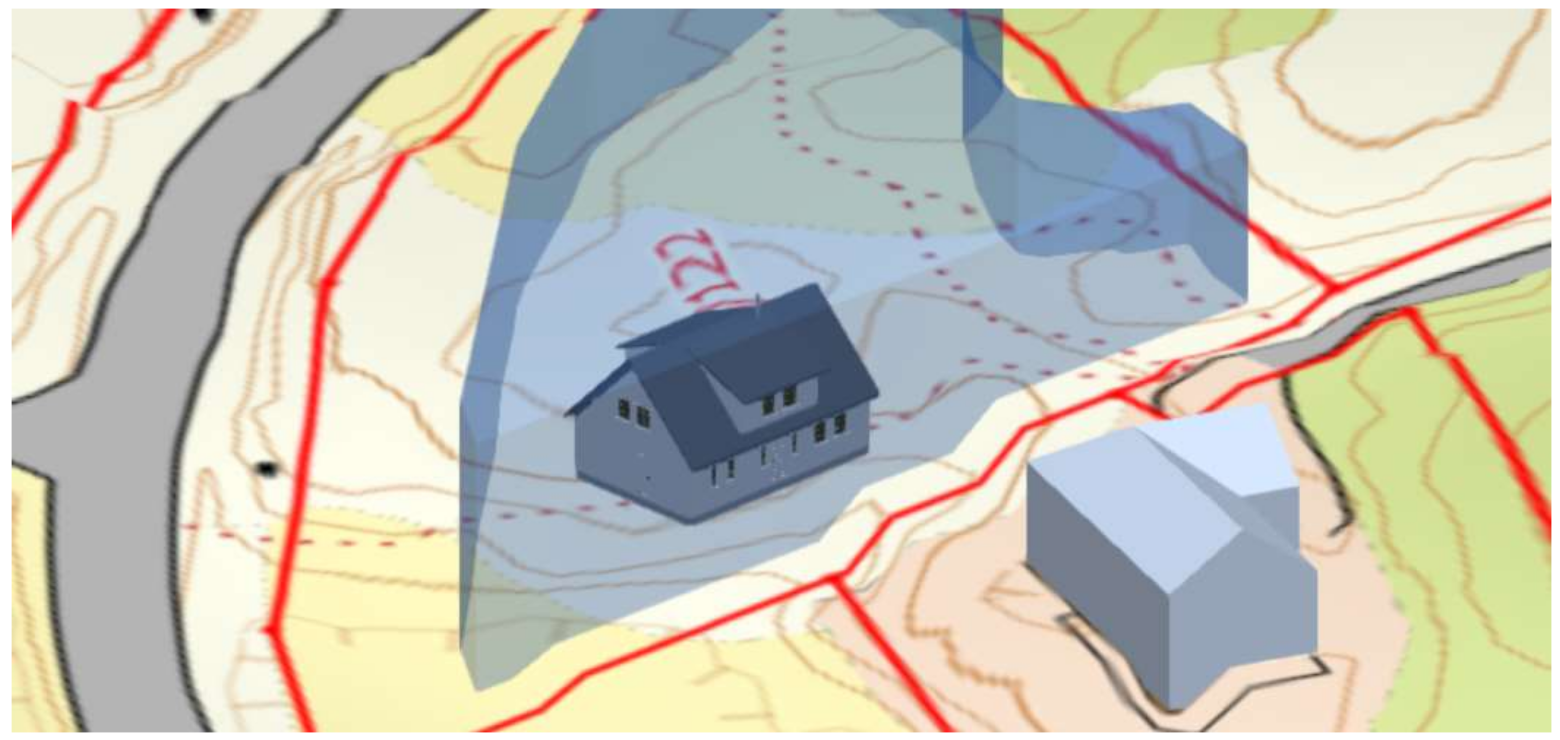
Currently, architectural or building projects are most often created by applying programs that allow visualisation in 3D space. Unfortunately, local spatial development plans are still being implemented on the 2D plane. Dimensions related to the height and depth of the objects that may arise in particular areas determined by local plans should be sought in the textual section of the planning papers. It seems fair to say that the traditional approach to spatial planning in 2D is already insufficient. This problem was noticed and one of its first solutions was presented in 2016 [34]. This presentation prepared by the Norwegian Ministry of Local Government and Modernisation showed a new approach to 3D planning. Its authors have indicated the direction of work to be done to create three-dimensional spatial planning. They moved the vertical dimension from the descriptive part to the graphical part. The planned areas of local spatial plan, covering whole cadastral parcels, were restricted according to the protection areas (i.e., natural hazards areas, landscape protection areas etc.) and boundaries there.
As a result, blocks appeared in the planning space in which new spatial development objects can be placed (Figure 2).
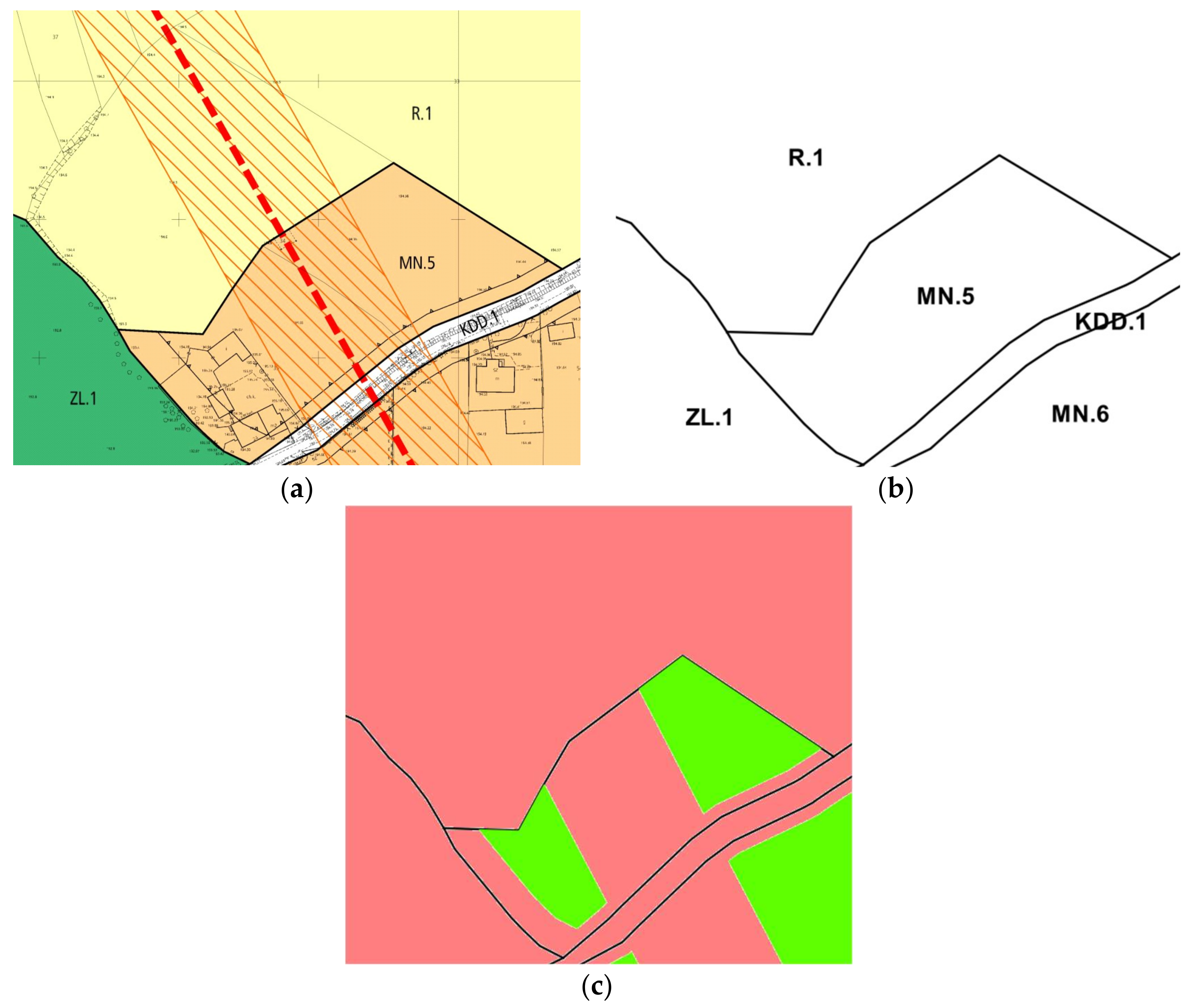
Undoubtedly, such land use plans enriched with a third dimension will, from a technical point of view, facilitate design and help in designating land for proper future land use. However, their practical implementation is much more difficult than in the case of two-dimensional plans. In order to transfer existing 2D local development plans into three-dimensional space, it is necessary to select the areas with varying designation and then the areas designated for building. The areas designated for building are shown in Figure 3.
In the presented fragment of a local spatial plan (Figure 3a), there are single-family housing development (MN) areas, agricultural areas (R), forests (ZL) and public roads (KDD). These particular areas are delimited in the planning space by demarcation lines. Their configuration is shown in Figure 3b.
According to the text section of the analysed local spatial development plan, no location of any new developments is allowed in the KDD, R or ZL areas. In addition, in the single-family housing development areas, new construction works may not be located closer to public roads and forest areas than the building development boundary line (line with triangles). The commencement of any development is also hindered by a high-voltage power line (red-dashes). The high-voltage power line with a protective buffer (orange hatch), forms an area of restricted building and development.
In reality, only after all these restrictions have been taken into account can we indicate areas in the planning space (Figure 3c) that can be built-up (green).
It should be noted that the lines in the local spatial plan do not always form closed shapes: for example, the line demarcating the land area designated for building development (Figure 3a). In such cases, it is not possible to directly use the line for the automatic identification of areas.
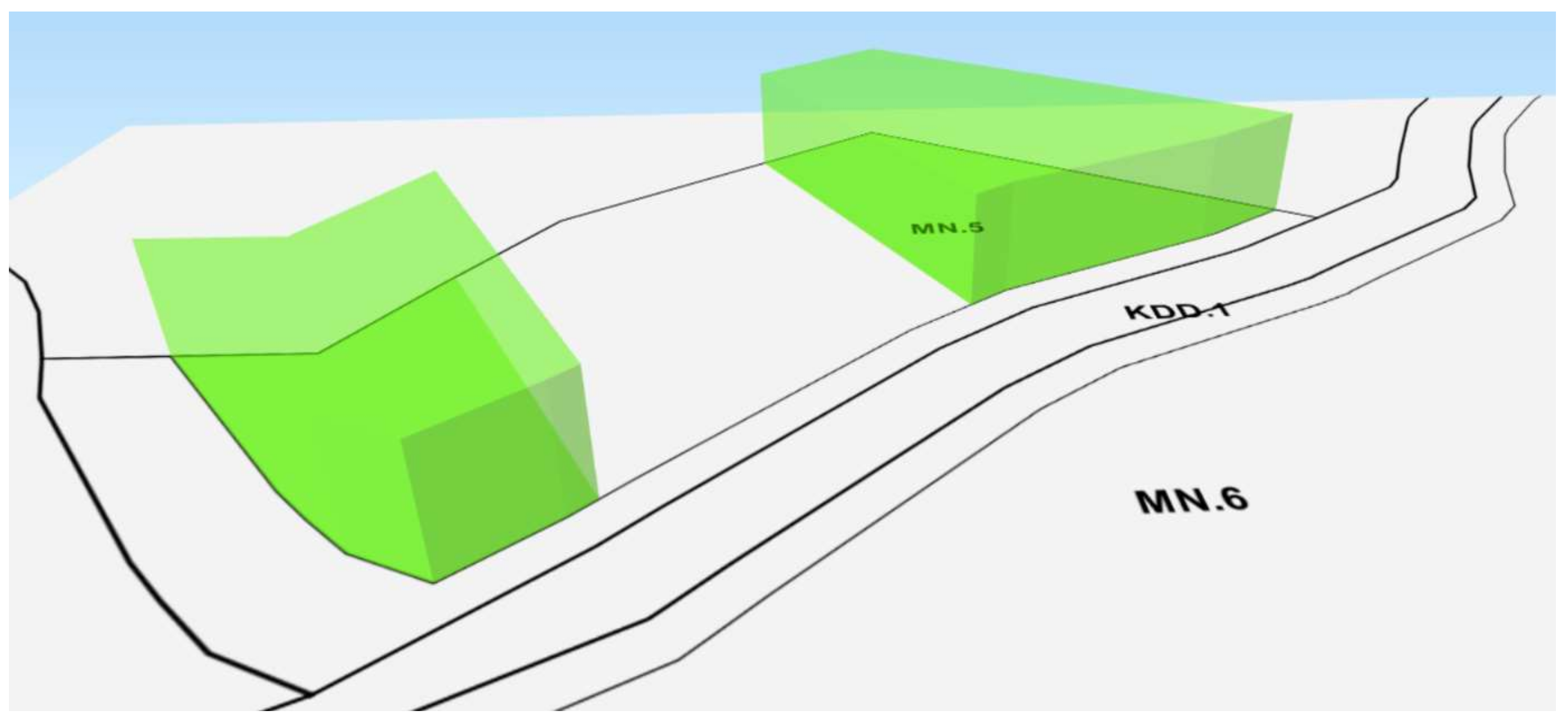
In general, objects constructed in this way can be introduced into the 2D planning database. To create a three-dimensional database, it should be considered whether all objects must be created in 3D. According to the analysed example of a local spatial development plan [36], the maximum height of the development in the MN areas is defined (9 metres in this case). It means that new objects can only be planned and built inside the new created structures—the 3D spatial planning objects (Figure 4).
6. Introducing Spatial Planning Objects to the Cadastral Model
In accordance with Polish regulations on spatial planning, the following elements should be included in the drawing of the local spatial development plan [23,25]:
- Boundaries of the area covered by the local spatial plan;
- Boundaries of the closed areas and their protection zones;
- Boundaries of areas protected on the basis of separate provisions (e.g., mining areas, areas at risk of flooding or landslides);
- Lines delimiting areas with different types of land use or development rules;
- Lines of possible development.
A need to supply the Polish cadastral model with some spatial planning components has appeared, and this idea goes hand-in-hand with the concept of building a multipurpose cadastre [2].
In the authors’ opinion, spatial planning databases and cadastral databases should be somehow connected. As there is no structure for a spatial planning database defined at the moment, this could be achieved by introducing some chosen spatial planning objects into the existing model of the cadastral database. The starting UML model used in this research is the model of a cadastral database defined in Polish law [27] which is enriched with some 3D cadastral objects [37]. Classes representing the Polish cadastral model have the prefix “EGB_”. For organizational purposes, classes concerning spatial planning are grouped into the UML “SpatialPlanning” package. UML classes representing spatial planning objects usually have long, descriptive names due to Polish legal regulations [23,25]. When referring to the spatial planning object the full name is given, whereas when the UML class is concerned the object name may be a little bit different according to the UML rules. For, example spaces and dashes are deleted.
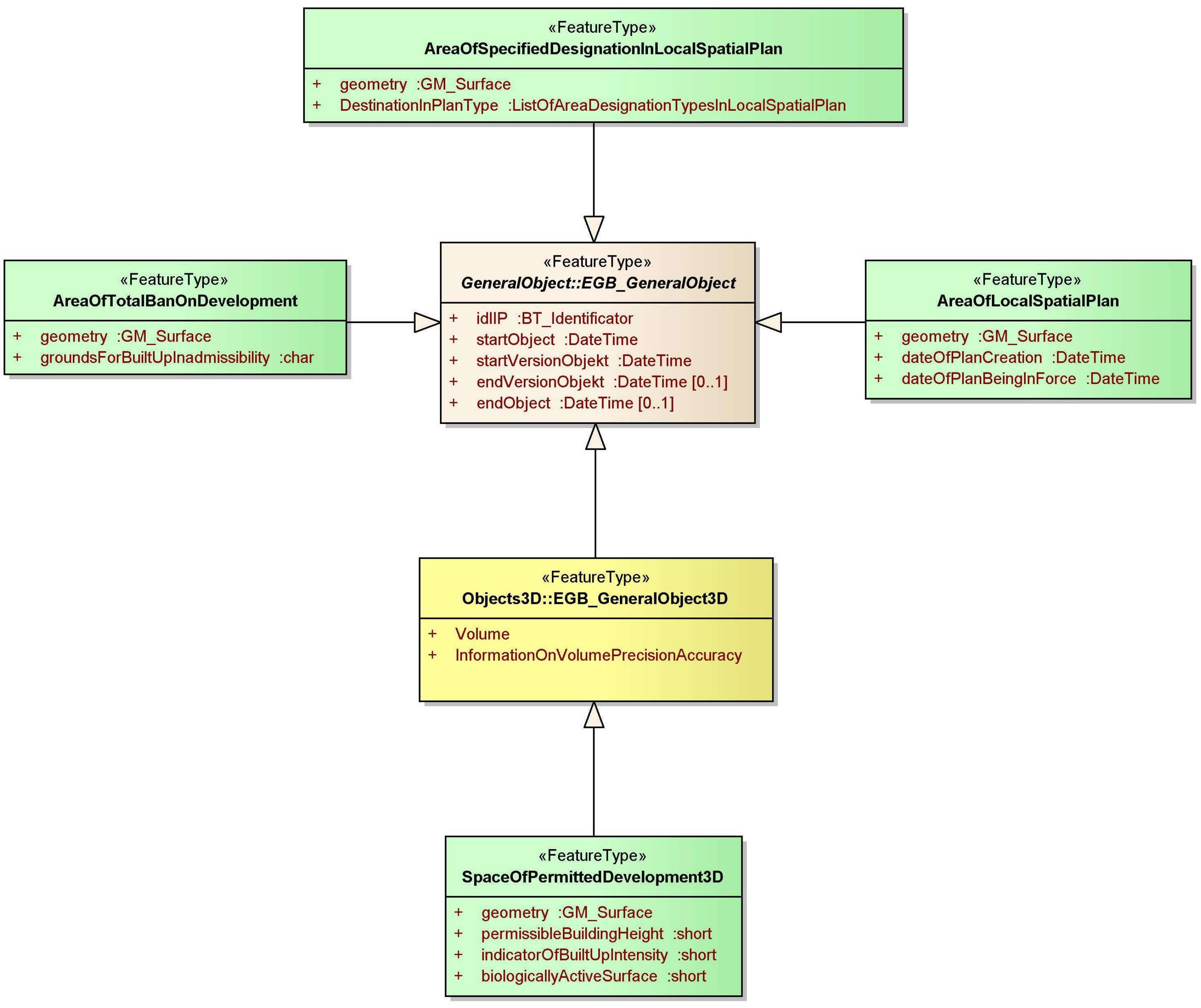
At the beginning of the modelling process, new UML classes concerning spatial planning (shown in green in the diagrams), both representing 2D and 3D objects were connected applying generalization relationships with the classes “EGB_GeneralObject” and “EGB_GeneralObject3D” of the Polish cadastre (Figure 5). The proposed classes representing 2D spatial planning objects such as “AreaOfLocalSpatialPlan”, “AreaOfSpecifiedDesignationInLocalSpatialPlan” and “AreaOfTotalBanOnDevelopment” inherit attributes from the “EGB_GeneralObject”. As a result of research described in Section 5, it was decided that the class representing areas for “SpaceOfPermittedDevelopment3D” represents a 3D object and therefore inherits attributes from the “EGB_GeneralObject3D” class.
Generally, inherited attributes concern the object’s identifier as well as the starting and ending data and time of the object and the duration of its versions. Attributes concerning volume are inherited from class “EGB_GeneralObject3D”.
“Area of Local Spatial Plan” represents the area covered by the single local spatial (development) plan. Planning activities are undertaken there, leading to the plan creation. In practice, it is the municipality area for which the plan or a fragment of it is being created [38].
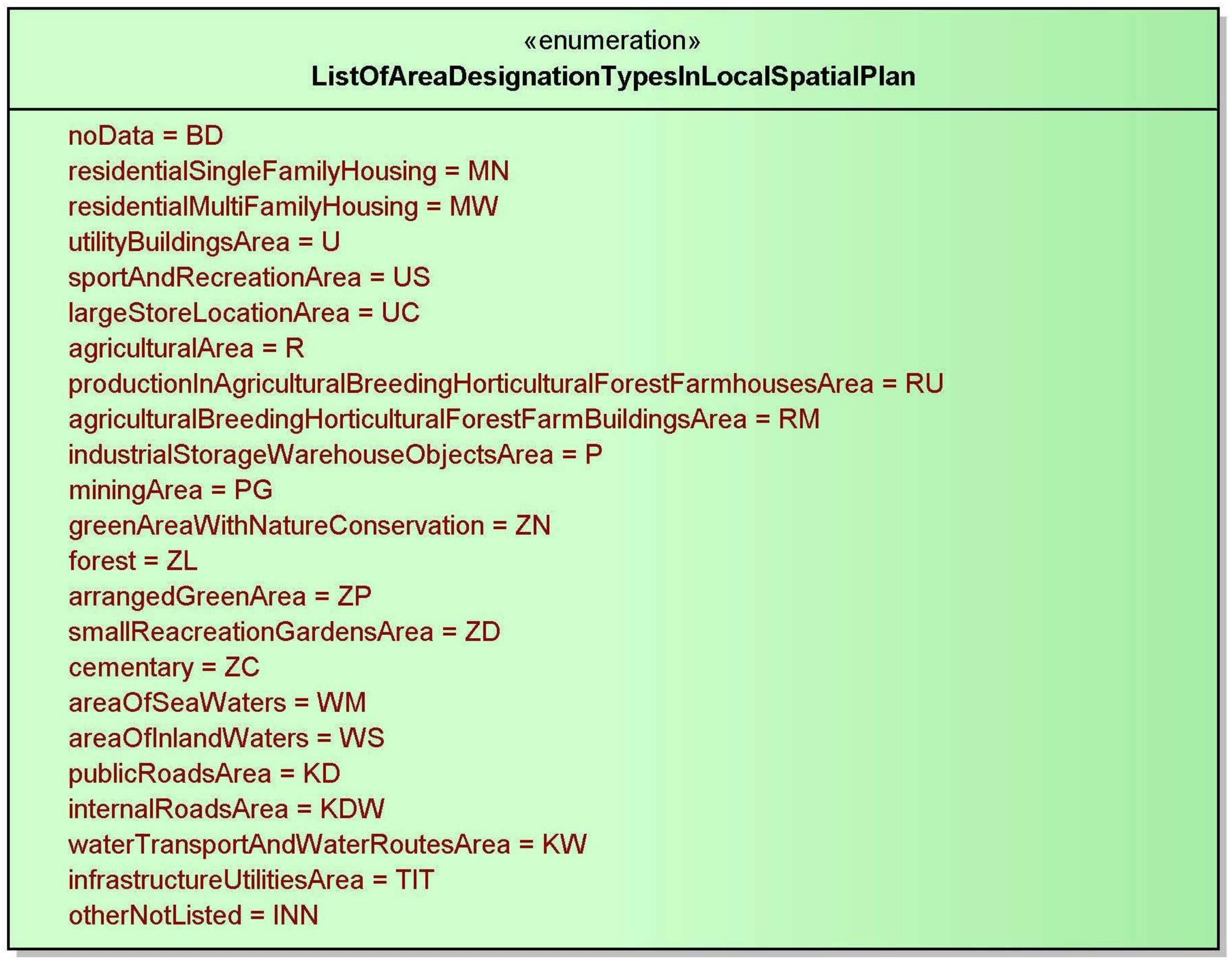
“Area of Specified Designation in Local Spatial Plan” is a part of “Area of Local Spatial Plan”, and is intended for specific purposes within which uniform rules of development apply [23]. Areas with specific designation fill the entire planning space without any gaps (Figure 3b). “Area of Specified Designation in Local Spatial Plan” only has values from “List of Area Designation Types in Spatial Plan” (Figure 6).
Apart from the areas designated in the local plan for specific purposes, the planning area also includes locations (points), continuous layouts (lines) and areas (zones) which may cause exceptions from development rules introduced for each “Area of Specified Designation in Local Spatial Plan”. For example, archaeological sites, viewpoints, natural monuments (i.e., points), roads, rivers, technical infrastructure (i.e., lines) and national parks, nature reserves (i.e., zones) may be located in an area entirely intended for residential development. This requires the establishment of protection zones [39] in the spatial plan. Most often, this protection means a total ban on development in a fragment of a specific “Area of Specified Designation in Local Spatial Plan” (Figure 3c). It may also happen that some areas are completely excluded from the possibility of building development (e.g., green or agricultural areas). Therefore, two additional classes, “Space of Permitted Development 3D” and “Area of Total Ban on Development” have been introduced to the model. These objects cannot have common parts and the sum of all such objects in the local plan coincides with the “Area of Local Spatial Plan” area.
“Area of Total Ban on Development” is the area with a total ban on development, while “Space of Permitted Development 3D” is the area that can be developed in a specific way. “Space of Permitted Development 3D” has been defined as 3D since it can be used for the creation of construction works, but only up to the height predefined in the local spatial plan (Figure 4). This means that the maximum height of new objects should be entered into the spatial planning database.
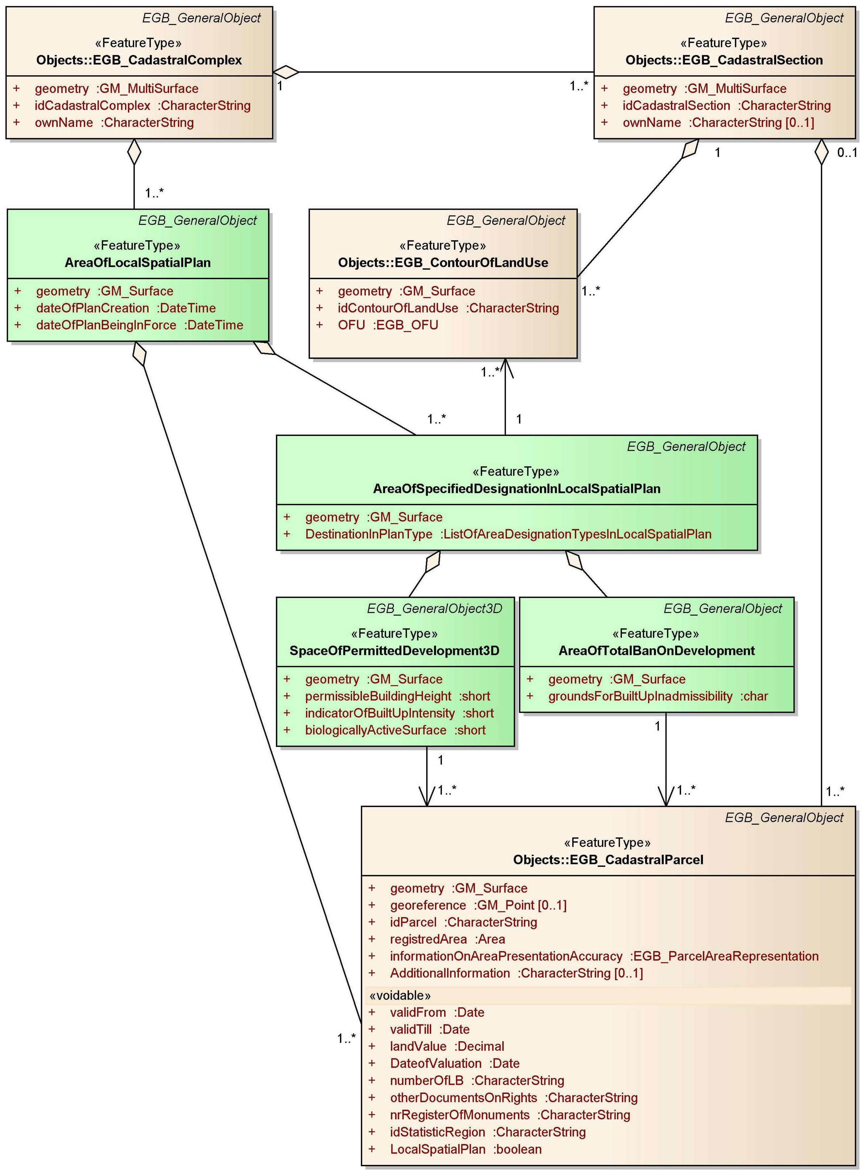
The next step of research was introducing UML classes representing spatial planning objects to the cadastral model. The classes representing corresponding objects of the Polish cadastre division are “EGB_CadastralComplex”, “EGB_CadastralSection” and “EGB_CadastralParcel”. The real-world object “Cadastral Section” generally encompasses small villages or is restricted by natural or customary boundaries. A “Cadastral Complex” usually encompasses a municipality, a town or a city district.
The spatial planning division is different. The local spatial plans are prepared for the municipality or a part of it, so the “Area of Local Spatial Plan” class representing such a plan is connected with the aggregation (meaning that it is part) of the relationship with the “EGB_CadastralComplex” class. The components of the local spatial plan are particular designation areas. In the UML diagram “Area of Specified Designation in Local Spatial Plan”, the class is connected with “Area of Local Spatial Plan” with an aggregation relationship. The “Area of Specified Designation in Local Spatial Plan” class points out (association) towards the “EGB_ContourOfLandUse” class. The “Space of Permitted Development 3D” and “Area of Total Ban on Development” classes corresponding to areas of possible or not possible development point into the class “Area of Specified Designation in Local Spatial Plan”. The “List of Area Designation Types in Spatial Plan” enumeration class is defined as well. The diagram comprising spatial planning classes and chosen classes of the cadastral model is presented in Figure 7.
It is worth noting that existing and planned “Areas of Local Spatial Plan” are irrespective of the cadastral section boundaries. The same situation occurs with “Area of Specified Designation in Local Spatial Plan” and cadastral parcels.
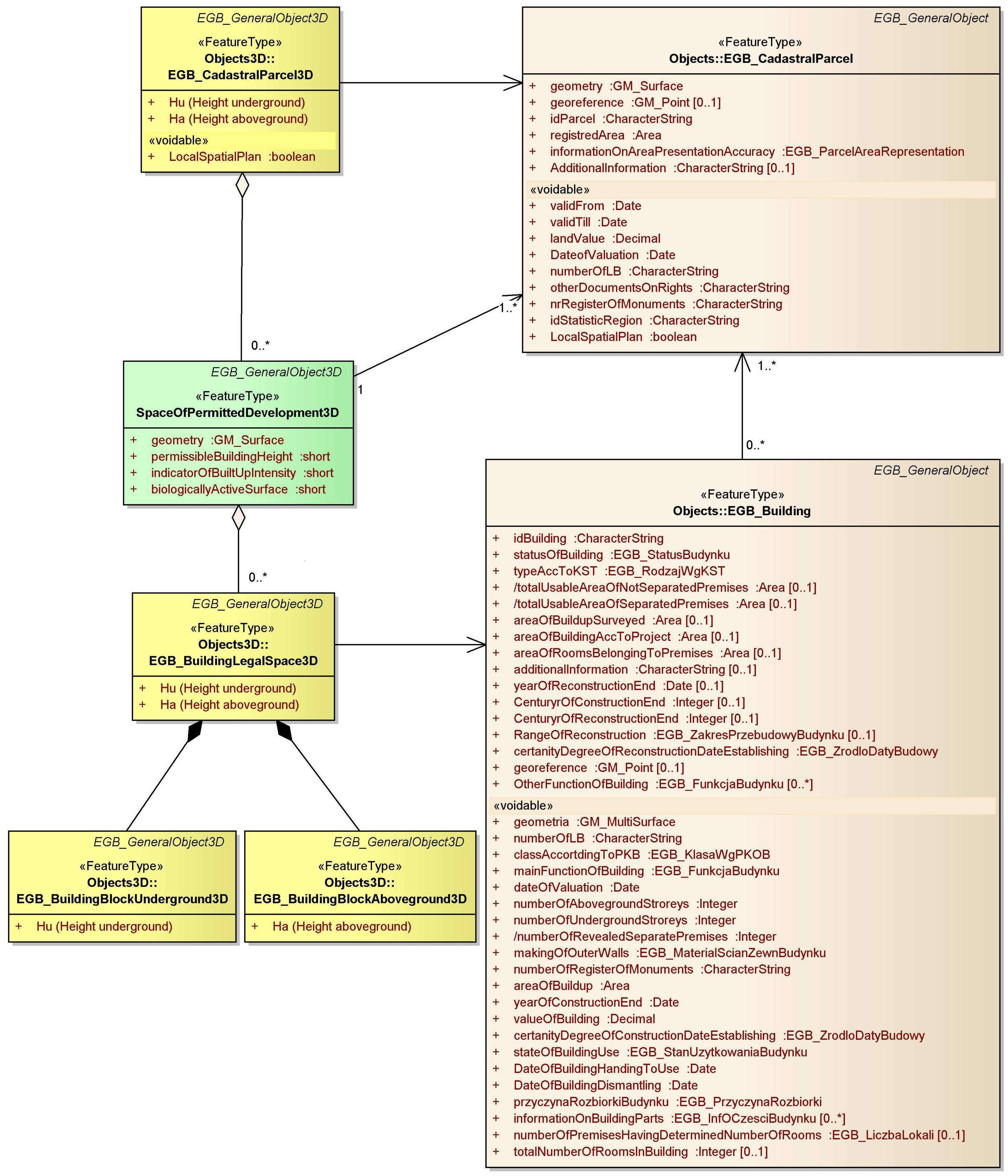
As was described earlier, the “Space of Permitted Development 3D” class represents a 3D spatial planning object, so it is introduced to the diagram presenting 2D and 3D cadastral parcels and buildings. This diagram is presented in Figure 8.
7. Discussion and Further Research
This paper presents the need to introduce 3D objects to spatial planning. In the research, the authors proposed to define UML classes representing spatial planning objects—four classes representing spatial objects and one enumeration class. As there is no model of a spatial planning database and spatial planning is strongly dependent on cadastral data, the authors introduced these classes to the cadastral model.
“Spatial planning/zoning with legal implications” is one of the topics that is planned under the “potential conceptual model extensions” of ISO 152 that were discussed at the 6th Land Administration Domain Model (LADM) Workshop [40]. It can be assumed that the future introduction of spatial planning to ISO 19152 will help to better organize the issues linking the cadastre (including the 3D one) and spatial planning.
One of the “application schema, technical models and encodings (for schema and data)” topics that are being considered in future LADM revision is CityGML. As one of its modules is “Land Use”, containing areas that reflect different land uses, such as urban, agricultural, etc. [41], it can also be taken into account in future works.
Spatial planning classes implemented in the cadastral database can create many new possibilities for rapid space analysis. In addition, if the content is partly three-dimensional, it may significantly facilitate decision-making related to development processes. The authors think that the integration of the 3D cadastre and 3D spatial planning is going to be appreciated by the professionals working with urban planning as well as architectural and constructional design. The “Space of Permitted Development 3D” class may be particularly important. The space determined by it will immediately indicate what part of the space designated for the development can actually be used as the construction object.
The cadastral model used in the study has been defined by legal regulations [16] and enriched by 3D cadastral objects [30]. The study does not cover all aspects at the cadastre and planning interface, so further research seems necessary. In the opinion of the authors, such research could focus on the following aspects:
- Investigation of creating more classes representing spatial planning objects: i.e., not only areas but points (e.g., archaeological sites) or lines (e.g., electric or communication), as well as classes concerning dictionaries (enumeration or code list);
- Studies to build models or application schema for spatial planning;
- Studies for the implementation or connection of spatial planning classes or a model with the cadastral model;
- A very broad and comprehensive study may involve the creation of a spatial planning data model or application schema consisting of objects, a catalogue and diagrams.
Acknowledgments
This work was financed by research funds from the AGH University of Science and Technology, No. 11.11.150.006.
Author Contributions
Jarosław Bydłosz wrote about the cadastre in Poland and introducing spatial planning objects into the cadastral model. He also developed the UML model. Agnieszka Bieda prepared the chapters about spatial planning in Poland and introducing the 3D concept to spatial planning. Piotr Parzych made a literature overview and prepared the introduction. All the authors contributed to formulate the conclusion and provided directions for further research.
Conflicts of Interest
The authors declare no conflict of interest.
References
- Lewandowicz, E. Network models of 2D and 3D cadastral data. In Proceedings of the International Conference on Environmental Engineering, Vilnius, Lithuania, 22–23 May 2014; Available online: http://leidykla.vgtu.lt/conferences/ENVIRO_2014/Articles/5/227_Lewandowicz.pdf (accessed on 14 September 2017).
- Bennett, R.M.; Rajabifard, A.; Kalantari, M.; Wallace, J.; Williamson, I.P. Cadastral futures: Building a new vision for the nature and role of cadastres. In Proceedings of the XXIV FIG International Congress 2010, Sydney, Australia, 11–16 April 2010; Available online: http://www.fig.net/resources/proceedings/fig_proceedings/fig2010/papers/ts08k/ts08k_bennett_rajabifard_et_al_4096.pdf (accessed on 14 September 2017).
- Choi, J.; Hwang, M.; Kim, G.; Seong, J.; Ahn, J. Supporting the measurement of the United Nations’ sustainable development goal 11 through the use of national urban information systems and open geospatial technologies: A case study of south Korea. Open Geospat. Data Softw. Stand. 2016, 1, 2–9. [Google Scholar] [CrossRef]
- Pettit, C.J.; Cartwright, W.; Berry, M. Geographical visualization: A participatory planning support tool for imagining landscape futures. Appl. GIS 2006, 2, 22. [Google Scholar] [CrossRef]
- Batty, M.; Chapman, D.; Evans, S.; Haklay, M.; Kueppers, S.; Shiode, N.; Smith, A.; Torrens, P.M. Visualizing the City: Communicating Urban Design to Planners and Decision-Makers; Technical Report Paper 26; Centre for Advanced Spatial Analysis (UCL): London, UK, 2000. [Google Scholar]
- Biljecki, F.; Stoter, J.; Ledoux, H.; Zlatanova, S.; Çöltekin, A. Applications of 3D city models: State of the art review. ISPRS Int. J. Geo-Inf. 2015, 4, 2842–2889. [Google Scholar] [CrossRef] [Green Version]
- Sabri, S.; Pettit, C.J.; Kalantari, M.; Rajabifard, A.; White, M.; Lade, O.; Ngo, T. What are essential requirements in planning for future cities using open data infrastructures and 3D data models. In Proceedings of the 14th International Conference on Computers in Urban Planning and Urban Management (CUPUM 2015), Cambridge, MA, USA, 7–10 July 2015; p. 314. [Google Scholar]
- 3D Spatial Planning and 3D Cadastre. Delft, The Netherlands, 31 October 2016. Available online: http://wiki.tudelft.nl/bin/view/Research/ISO19152/GeoDesignSummitEU2016 (accessed on 14 September 2017).
- Çoruhlu, Y.E.; Demir, O.; Yıldız, O.; Çete, M. The relation between structured cultural heritages and condominium towards 3D cadastre. Surv. Rev. 2016, 48, 438–449. [Google Scholar] [CrossRef]
- Hełdak, M.; Szczepański, J.; Patrzalek, C. Using the 3D computer scanning method in the environmental impact assessment. Infrastruct. Ecol. Rural Areas 2012, 1/4, 49–59. Available online: http://yadda.icm.edu.pl/yadda/element/bwmeta1.element.agro-ed854fcc-9bf6-4c58-bbdd-e3ae7ce8b551/c/05-1.pdf (accessed on 31 July 2017).
- Aydin, C.C. Usage of Underground Space for 3D Cadastre Purposes and Related Problems in Turkey. Sensors 2008, 8, 6972–6983. [Google Scholar] [CrossRef] [PubMed]
- Cirulisa, A.; Brigis Brigmanis, K. 3D Outdoor Augmented Reality for Architecture and Urban Planning. Procedia. Comput. Sci. 2013, 25, 71–79. [Google Scholar] [CrossRef]
- Golub, D.; Doytsher, Y.; Fisher-Gewirtzman, D. 3D visibility analysis indicating quantitative and qualitative aspects of the visible space. Surv. Rev. 2017, 134–146. [Google Scholar] [CrossRef]
- Wu, H.; He, Z.; Gong, J. A virtual globe-based 3D visualization and interactive framework for public participation in urban planning processes. Comput. Environ. Urban Syst. 2010, 34, 291–298. [Google Scholar] [CrossRef]
- Engman, H. Web-based 3D in Urban Planning. GIM International 2016. Available online: https://www.gim-international.com/content/article/web-based-3d-in-urban-planning (accessed on 14 September 2017).
- Herbert, G.; Chen, X. A comparison of usefulness of 2D and 3D representations of urban planning. Cartogr. Geogr. Inf. Sci. 2015, 42, 22–32. [Google Scholar] [CrossRef]
- Alavipanaha, S.; Haase, D.; Lakes, T.; Qureshi, S. Integrating the third dimension into the concept of urban ecosystem services: A review. Ecol. Indic. 2017, 72, 374–398. [Google Scholar] [CrossRef]
- Lemmen, C.; Van Oosterom, P.; Bennett, R. The Land Administration Domain Model. Land Use Policy 2015, 49, 535–545. [Google Scholar] [CrossRef]
- Kitsakis, D.; Dimopoulou, E. Addressing Public Law Restrictions within a 3D Cadastral Context. ISPRS Int. J. Geo-Inf. 2017, 6, 182. [Google Scholar] [CrossRef]
- Bieda, A.; Bydłosz, J.; Parzych, P. Preliminary assessment of urban planning documents in the Cracow area published on the Internet. In Proceedings of the International Multidisciplinary Scientific GeoConference SGEM: Surveying Geology & mining Ecology Management, Cartography and GIS, Albena, Bulgaria, 30 June–6 July 2016; Volume 3, pp. 367–374. [Google Scholar]
- Act of 18 May 1989–Law on Geodesy and Cartography (Journal of Laws No. 30, item 163, as Amended). Available online: http://isip.sejm.gov.pl/isap.nsf/download.xsp/WDU19890300163/U/D19890163Lj.pdf (accessed on 31 July 2017).
- Stoter, J.; Ploeger, H.; van Oosterom, P. 3D cadastre in the Netherlands: Developments and international applicability. Comput. Environ. Urban Syst. 2013, 40, 56–67. [Google Scholar] [CrossRef]
- Act of 27 March 2003 on Spatial Planning and Development—Consolidated Text (Journal of Laws from 2015 Item 199). Available online: http://isip.sejm.gov.pl/isap.nsf/download.xsp/WDU20030800717/U/D20030717Lj.pdf (accessed on 31 July 2017).
- Regulation of Ministry of Administration and Digitization from 29th of March 2001 Concerning the Land and Building Cadastre—Consolidated Text (Journal of Laws from 2016, Item 1034). Available online: http://isip.sejm.gov.pl/isap.nsf/download.xsp/WDU20160001034/O/D20161034.pdf (accessed on 31 July 2017).
- Regulation of the Minister of Infrastructure on the Required Scope of the Project of Local Spatial Development Plan of 26 August 2003 (Journal of Laws No. 164, Item 1587). Available online: http://isip.sejm.gov.pl/isap.nsf/download.xsp/WDU20031641587/O/D20031587.pdf (accessed on 31 July 2017).
- ISO. Geographic Information–Land Administration Domain Model (LADM); ISO 19152:2012; International Organization for Standardization: Geneva, Switzerland, 2012. [Google Scholar]
- Regulation of Ministry of Administration and Digitization from 29th of November 2013 Changing the Regulation on Land and Building Cadastre (Journal of Laws from 2013, Item 1551). Available online: http://isip.sejm.gov.pl/isap.nsf/download.xsp/WDU20130001551/O/D20131551.pdf (accessed on 31 July 2017).
- Bydłosz, J. The application of the Land Administration Domain Model in building a country profile for the Polish cadastre. Land Use Policy 2015, 49, 598–605. [Google Scholar] [CrossRef]
- Koreleski, K. The system of spatial planning and land management in Poland. Geomat. Environ. Eng. 2009, 3, 27–42. Available online: http://journals.bg.agh.edu.pl/GEOMATICS/2009-02/Geomatics_2009_2_02.pdf (accessed on 14 September 2017).
- Adamczyk, T.; Bieda, A. Intended Use of Real Estate as a Time Changeable Attribute for Determining Compensation for Nationalized and Expropriated Lands. Real Estate Manag. Valuat. 2014, 22, 35–50. [Google Scholar] [CrossRef]
- Bieda, A.; Parzych, P. Development of spatial politics of monumental towns based on Krakow example. In Proceedings of the International Multidisciplinary Scientific GeoConference SGEM: Geodesy and Mine Surveying, Photogrammetry and Remote Sensing, Albena, Bulgaria, 16–22 June 2013; Volume 2, pp. 143–150. [Google Scholar]
- Andrzejewska, M.; Hejłasz, B.; Rusztecka, M.; Starczewski, D. Towards Sustainable Spatial Planning—Harmonization of Spatial Data for the Land Use Case Study in Poland. In Proceedings of the INSPIRE—Geospatial World Forum 2015, Lisbon, Portugal, 25–29 May 2015; Available online: http://geospatialworldforum.org/speaker/SpeakersImages/Maria%20Andrzejewska.pdf (accessed on 31 July 2017).
- Directive 2007/2/EC of The European Parliament and of the Council of 14 March 2007 Establishing an Infrastructure for Spatial Information in the European Community (INSPIRE). Available online: http://eur-lex.europa.eu/legal-content/EN/TXT/?uri=CELEX:32007L0002 (accessed on 31 July 2017).
- Bakken, H.J.; Overli, T.G. Improved land use planning in 3D. In Proceedings of the INSPIRE—Geospatial World Forum 2016, Barcelona, Spain, 26–30 September 2016; Available online: http://inspire.ec.europa.eu/events/conferences/inspire_2016/pdfs/2016_psessions/29%20THURSDAY_PSESSIONS_H1_14.00-15.30______Presentasjon-inspire290916.pdf (accessed on 31 July 2017).
- 3D Visualization of the Area for Built-up Using the Application. Available online: http://bygglett.catenda.com/nysak (accessed on 31 July 2017).
- Resolution No. LI/939/16 of the Council of the City of Krakow of 31 August 2016 on adopting the local spatial development plan for the “Nowa Huta Przyszłości-Przylasek Rusiecki” area (Official Journal of the Małopolskie Voivodeship from 2016, item 5207). Available online: https://www.bip.krakow.pl/_inc/rada/uchwaly/show_pdf.php?id=13611 (accessed on 31 July 2017).
- Bydłosz, J. Developing the Polish cadastral model towards a 3D cadastre. In Proceedings of the 5th International FIG 3D cadastre workshop, Athens, Greece, 18–20 October 2016; pp. 505–518. Available online: https://www.fig.net/resources/proceedings/2016/2016_3dcadastre/3Dcad_2016_38.pdf.pdf (accessed on 14 September 2017).
- Bieda, A.; Hanus, P.; Hycner, R. Geodetic Aspects of Spatial Planning and Selected Design Studies; Gall Publishing House: Katowice, Poland, 2012. [Google Scholar]
- Adamczyk, T.; Begović, V.; Bieda, A.; Bielecka, E.; Bugaj, P.; Dawidowicz, A.; Džunić, I.; Gajos, M.; Jankowska, M.; Kereković, D.; et al. Spatial data in wide Geospace; Nacionalna knjižnica: Zagreb, Croatia, 2014. [Google Scholar]
- The 6th Land Administration Domain Model (LADM) Workshop. Available online: https://wiki.tudelft.nl/bin/view/Research/ISO19152/WorkshopAgenda2017 (accessed on 26 March 2018).
- City GML Homepage. Available online: www.citygml.org (accessed on 26 March 2018).
Figure 1.
Scheme of connections between cadastre and spatial planning (authors’ own study based on [20]).
Figure 1.
Scheme of connections between cadastre and spatial planning (authors’ own study based on [20]).

Figure 2.
The 3D visualization of an area designated for building. Prepared with an application available at http://bygglett.catenda.com/nysak [35].
Figure 2.
The 3D visualization of an area designated for building. Prepared with an application available at http://bygglett.catenda.com/nysak [35].

Figure 3.
The identification of areas for building based on spatial plans: (a) part of a binding local spatial development plan with a base map in the background, (b) areas designated differently, (c) areas that could potentially be developed (green colour) and areas where building is not possible (red colour). Source: authors’ own study based on [36].

Figure 4.
The transformation of 2D spatial planning objects into 3D.

Figure 5.
Generalization relationships between classes “EGB_GeneralObject”, “EGB_GeneralObject3D” and classes representing spatial planning objects.
Figure 5.
Generalization relationships between classes “EGB_GeneralObject”, “EGB_GeneralObject3D” and classes representing spatial planning objects.

Figure 6.
Class representing list of area designation types in local spatial plan.

Figure 7.
Diagram comprising spatial planning classes and cadastral model classes connected to spatial planning.
Figure 7.
Diagram comprising spatial planning classes and cadastral model classes connected to spatial planning.

Figure 8.
Diagram comprising 2D and 3D cadastral parcels and buildings with the “Space of Permitted Development 3D” class introduced.
Figure 8.
Diagram comprising 2D and 3D cadastral parcels and buildings with the “Space of Permitted Development 3D” class introduced.

© 2018 by the authors. Licensee MDPI, Basel, Switzerland. This article is an open access article distributed under the terms and conditions of the Creative Commons Attribution (CC BY) license (http://creativecommons.org/licenses/by/4.0/).
Share and Cite
MDPI and ACS Style
Bydłosz, J.; Bieda, A.; Parzych, P. The Implementation of Spatial Planning Objects in a 3D Cadastral Model. ISPRS Int. J. Geo-Inf. 2018, 7, 153. https://0-doi-org.brum.beds.ac.uk/10.3390/ijgi7040153
AMA Style
Bydłosz J, Bieda A, Parzych P. The Implementation of Spatial Planning Objects in a 3D Cadastral Model. ISPRS International Journal of Geo-Information. 2018; 7(4):153. https://0-doi-org.brum.beds.ac.uk/10.3390/ijgi7040153
Chicago/Turabian StyleBydłosz, Jarosław, Agnieszka Bieda, and Piotr Parzych. 2018. "The Implementation of Spatial Planning Objects in a 3D Cadastral Model" ISPRS International Journal of Geo-Information 7, no. 4: 153. https://0-doi-org.brum.beds.ac.uk/10.3390/ijgi7040153
Note that from the first issue of 2016, this journal uses article numbers instead of page numbers. See further details here.