1. Introduction
The Hellenic cadastral project was initiated in 1995. To choose the most appropriate methodology and technical specifications for its compilation, several issues have been seriously considered by the local experts and authorities. Traditionally, cadastral field surveying involves the participation of right holders and/or other local residents to adjudicate rights, right holders, and parcel boundaries in the field, or the demarcation of the parcel boundaries on the ground prior to the air photography, if photogrammetric procedures are to be implemented. However, field surveying of each cadastral parcel was considered to be unaffordable for Greece. Additionally, the demarcation of every boundary node on the ground prior to the aerial photography was also considered to be complicated and costly for a nation-wide cadastral survey. Besides, it was realized early that technology improves fast so it would not be wise to prescribe by law the exact methodology to be used, but it was preferable to make it flexible for the private sector to choose the fit-for-purpose method (e.g., field survey or photogrammetry or combination of them) according to the situation. Thus, the technical specifications prescribed only the required accuracies of the final product. It was also decided that the project would be compiled by the private sector, through a tender procedure, in several phases and it would start with pilot studies (mainly in urban areas where most property rights exist) to investigate the problems. Contractors were expected to compile basemaps and right holders were asked to submit their rights (deeds /titles and any other additional document/surveying plan) and identify the parcel on the basemap.
In the earlier phases, right holders were asked to either visit the local cadastral survey office and locate the parcel boundaries on an aerial photo or an orthophoto with the help of the cadastral surveyor and/or local experts at the office. At a later phase, right holders could use the internet to enter a single point within the parcel. In the latter case, that single point was used by the contractors to identify the actual parcel boundaries using the deed information as a guideline. This approach worked well for urban areas where the majority of parcel boundaries and buildings are easily identifiable on photos/images.
The last phase of the project began in early 2019 and was the most difficult one as it mainly concerned rural areas where parcel boundaries are not demarcated on the ground and patterns on images are confusing due to similar vegetation; also, some are invisible. Still, field-surveying the whole territory would not be affordable.
Using the same methodology for the rural areas was proved to be not feasible mainly because of two reasons:
(a) the use of internet and digitization of a single point within the parcel was not sufficient and could not help the contractor to identify the actual boundaries of rural parcels, so the right holders had to visit the cadastral declaration office, and
(b) identification of the rural parcels on orthophotos at the office, was not at all a simple job; neither for the right holders nor for the personnel of the cadastral survey office who had to dedicate a long time helping each right holder, especially the elderly; in that case, the procedure became unprofitable and not successful.
It was then obvious that a larger involvement of crowdsourcing methodology is the only viable solution (fit-for-purpose approach) within the projects’ budget and time constraints. For this purpose, a methodology and a technical tool had to be developed to facilitate such a process. The research methodology that was followed to reach a definite result was:
Perform research in international literature
Test the crowdsourcing methodology to ensure that the demanding Cadastre requirements are met
Establish a committee of experts to consult and co-design the application
Develop the appropriate software to meet the requirements
Test the software through various environments
Production
The main objective of this paper is to describe the development of this technical tool (two applications) that enables crowdsourced identification and digitization of parcel boundaries and electronic submission of all rights and other documents by the right holders/citizen alone, without the need of professional involvement. This crowdsourced identification of parcel boundaries should be possible either in the field or from home/work. The tool should be simple to use, should serve all cases, and should be able to support multiple users simultaneously. The tool should also allow spatial data validation, an automated checking of the crowdsourced spatial data for the majority of the cases, so that all gross errors in the geospatial location of the property units will be avoided.
First, a literature review of the state-of-the-art in applying crowdsourcing in land administration is given; then a brief description of the considerations, criteria, and requirements set for the design of such a tool follows; the system architecture and functioning mechanism is briefly explained; the automated controls of the submitted data are described; and constraints, factors to consider, problems introduced, and solutions given are discussed, in a real-life example of using a crowdsourcing methodology officially for the collection of cadastral information.
2. Literature Review
Since the launch of the internet and the creation of the online world in the 1990s, a new branch of economics called the digital economy or internet economy or web economy gradually emerged and has been defined as the branch of economics studying zero marginal cost of intangible goods over the internet. Digital networking and communication infrastructures have provided a global platform over which people and organizations devise strategies, interact, communicate, participate, collaborate, and search for information. New terminology has appeared in the everyday life of e-government (electronic government), e-business, e-commerce, e-democracy, e-participation, and m-government (mobile government meaning services provided through mobile phones and wireless internet) [
1,
2]. The various National Mapping Agencies (NMAs) have been experimenting on providing e-services (electronic services) to people as well as m-services (mobile services provided through wireless internet for mobile phones) [
3] and crowdsourcing as the extended use of Internet and smart and affordable devices became a fact [
2,
4].
The Hellenic Cadastral project has been implemented through several phases with quite different procedures [
5]. Initially the project had little dependence on automation and IT processes. Thus, the right holders had to bring all available documents (titles/deeds and surveying plans) and visit the contractors’ offices (private companies responsible for the data collection) to submit their cadastral declaration on-site.
In 2007, during the phase of a major assessment of the project’s progress, it was decided to modernize the Cadastral Agency according to the current international trends. Main goal of this upgrade was to develop e-services and processes in order to (a) minimize the required human effort and (b) increase efficiency and maximize the benefits of the available technologies and the cloud. All contractors were connected, real time, to centrally allocated IT systems over secure networks. Right holders were given the option to submit all documents for their property rights from a distance, through Internet, within the comfort of their home or office.
In the following years, an international in-depth research was initiated investigating the options of introducing crowdsourcing technology and the use of smart phones in the cadastral surveying for the collection of cadastral data directly by non-professionals [
6,
7,
8]. Some publications have been published on investigating: the potential of data collection through crowdsourcing for land administration and on defining a draft procedure on how this may be achieved [
9,
10]. In parallel, research was focused on various critical success factors when using crowdsourcing technology. Investigating the citizens’ motivation over a potential participation [
11] examined the key factors needed to promote people’s interest in crowdsourcing. Other studies focused on assessing the OpenStreetMap contributors and their contributions [
12] or comparing accuracy between crowdsourced data and official mapping [
13,
14]. In order to evaluate crowdsourced data, other studies focused on defining measures and indicators for evaluating VGI quality [
15]. Land administration has different constraints and demands so some studies examined the option of using OpenStreetMap as a basemap for cadastral surveying [
16] and promoted the need to build a conceptual framework for utilizing VGI in land administration [
17]. Crowd sourcing nowadays is bound to mobile devices driving other studies to examine the potential of mobile applications using an accurate orthophoto as basemap in an effort to check the reliability, achieved geometric accuracy, and usability of the method for the compilation of accurate, assured, and authoritative cadastres such as the Hellenic Cadaster [
18]. Various technological solutions for citizens’ participation into cadastral mapping [
19], as well as policy solutions [
20] have been tested with good results. The applicability of crowdsourced geospatial information to real cadastral data, as tested in New Zealand Cadastre [
21] and in Greece, based on the gained experience so far [
22] which portrayed promising results as well. The research in using crowdsourcing in land administration was continued in order to check the achieved geometric accuracies and to assess the potential of applying crowdsourced methodology for accurate and reliable cadastral surveying for the initial registration both in urban and rural areas in countries with developed economies that are still under cadastral surveying [
23] and on investigating new roles for professionals and citizens or right holders for accurate and reliable 2D crowdsourced cadastral surveys [
24]. Other studies focused on the efficiency of applying crowdsourcing in land administration in the post conflict and developing world [
25,
26,
27,
28], in order to speed up the cadastral surveying and the first registration process in the economies in transition [
29,
30]. Once researchers and cadastral surveyors were convinced about the reliability and/or the efficiency of this technology international research was continued on developing a methodology for ensuring and motivating increased people participation in the cadastral surveying [
31]. Research in this field also continues in investigating tools and methods for using crowdsourcing and smart phones or other low-cost technology for the compilation of 3d reliable cadastral surveys [
32,
33,
34]; as well as in introducing it in the general work of the land surveyors and in the official map production [
3,
35].
Today, many processes are fully automated and improved IT services are provided to both contractors and right holders for the compilation of the Hellenic Cadastre. Contractors can now upload their deliverables, using digital certificates, and wait for the automated quality control results for both the descriptive and the spatial information. Right holders can use the Internet to get information about all aspects of the cadastral process beginning with the declaration of property rights and ending with the final result of the process. No legal reforms were needed in order to introduce such IT and crowdsourcing services into the Hellenic Cadaster. However, so far not all citizens are eligible to have access in the cadastral surveying procedure and data; the Hellenic Cadaster is not an open cadaster yet. For this project, only the right holders and/or their representatives participate and submit a declaration of property rights through the new e-services.
In the project phase prior to 2016, the right holders should only declare/digitize a single point on an orthophotomap (inside the parcel), in order to spatially locate the parcel of interest. This information, along with all submitted descriptive data, was passed to the contractor for further processing. The contractor had the responsibility to identify the parcel boundaries, taking into account all the provided additional information. That is a feasible approach for urban parcels, where the parcel boundaries are visible and can be easily recognized on the orthophoto, but it is totally insufficient for the rural parcels [
10]. The last cadastral phase, following 2016, targeted mainly on the rural parcels for the remaining Greek territory. This is the largest program ever commissioned in Greece that addresses the majority of the right holders. Experience from previous phases had already raised two major challenges:
The existing official web site for the cadastral declarations collection was too difficult to be used by the right holders, and
Selecting a single point inside the parcel was not adequate to locate and identify the parcel sufficiently. For rural parcels, all parcel boundary points should be identified on the orthophotomap and digitized.
To address the above-mentioned challenges, using the experience derived from the above-mentioned international literature research in the field of crowdsourcing in land administration, an in-house spatial tool with two new IT services were created, in 2019. The Cadastral Declaration Web Site (CDWS) and a parcel location helper for mobile phones. The scope of these services was to enable the large group of right holders, who vary in terms of age, gender, education, and digital skills, to easily identify and locate their property parcel and to complete the cadastral declaration process with less location gross errors, without any need for professional support.
The data collected would then be delivered to the contractors in order to corelate contract data with spatial data and decide on the actual parcel boundaries based on both citizen’s delineation and submitted contract information. The contractors would submit their proposed parcel fabric at a later time, within approximately one year after the declaration period was over. Those parcels would then be publicly exposed, along with the contract information, for all citizens to see and submit their objections, if any. The contractors would then evaluate each objection and propose a solution based on the new information received. The new proposal will go through independent committees, composed of both lawyers and surveyors, in order to decide on the final status of both spatial and legal information. That status can only be changed at courts.
3. Main Requirements for the Design of the Spatial Tool
A team of cadastral experts from the Hellenic Cadastral Agency of various fields, such as surveyors, IT experts, lawyers, media experts, and help desk specialists was created to help in the software design phase. The design phase lasted for several months, until the compilation of a flow chart that was both sufficient and easy to follow. It was agreed that the general requirements that every software tool, planned to be used for such a nation-wide project, should satisfy for its smooth function refer to its “usability”, “security”, and “scalability”. Within this concept, the design of the tool was thoroughly discussed. The team provided the necessary input for the creation of several mockups resembling the actual process.
Crowdsourced parcel boundaries and property rights declared by non-experts is a challenge especially in the rural areas, where legal boundaries are not recognizable and/or demarcated on the ground. Land use-parcel boundaries do not coincide with property-parcel boundaries in the rural areas as in several property parcels the same type of agricultural products may be cultivated (e.g., olive trees, orange trees, vineyards, vegetables, etc.). The tool under development should offer an easy way for completing the declaration process with minimal effort by the user.
In terms of “usability”, the agreed main guiding characteristics are: (a) the User Interface should provide distinct steps in a flow, (b) the system should be able to indicate all possible errors per step and in general, and (c) all searches should be single field based, meaning that each user would enter the information that was known to him/her and the system should try to correlate with all available data such as localities, points of interest, etc.
“Security” is a common requirement of all software packages used in the National Mapping Agencies. For the Hellenic Cadaster project there is a special legal constraint in the spatial location process. For reasons of national security, high resolution, accurate orthophotos are not allowed to be exposed as web services either using OGC or proprietary standards without enhanced security. That meant that a security tier should be introduced to provide the enhancement needed which was more than authentication and Secure Sockets Layer (SSL). This made the technological selection more complicated, introducing “scalability” issues.
The cadastral data collection period for this phase of the project was planned to begin at the beginning of 2019 in order to support declarations for approximately thirty million expected property rights. Contractors would need to use about 6,000 concurrent user positions in all their offices, while it was estimated that about thirty percent of all declarations would be submitted through the Internet. The system had to be able to provide stable and fast services while using the security constraints enforced by the National Security Agency.
Vector portrayal was another big concern in terms of scalability. Various vector layers were expected to be drawn on the orthophotograph for each user. Standard pre-caching could not be applied because the vector layers are frequently changing, and it would take a long time to cache all the information especially in larger scales. On the other hand, dynamic vector image creation (upon request) was not applicable as well, because it would require a vastly larger infrastructure in terms of hardware, since each user request would require server resources to dynamically create images.
Furthermore, the required capacity support of the system to enable 3D terrain viewing for all users added another layer of difficulty in addressing the “scalability” issues.
Finally, the system should also provide an automated quality control of the submitted data to avoid gross errors and to allow on-line payment of registration fees.
4. System Architecture
The agreed requirements proved that neither commercial off-the-shelf (COTS) nor open source software could address all issues especially in the case of dynamic vector data imaging for thousands of concurrent users using specific hardware restrictions. Available software offered either pre-caching or dynamic creation of images or vectors, which, as previously explained would require a larger infrastructure than what was available. Security constraints such as specific Time to Live (TTL) and encryption per request and per user for the orthophotos induced another layer of complexity that the existing software did not offer. Existing software provides SSL encryption, user login, and roles for protection of requests on spatial web services. When utilizing the above restrictions, it is still possible to create an automated process to extract basemap information from those services. National security requires that the web services exposing accurate basemap information should not be prone to automatic extraction, even if authentication is being utilized.
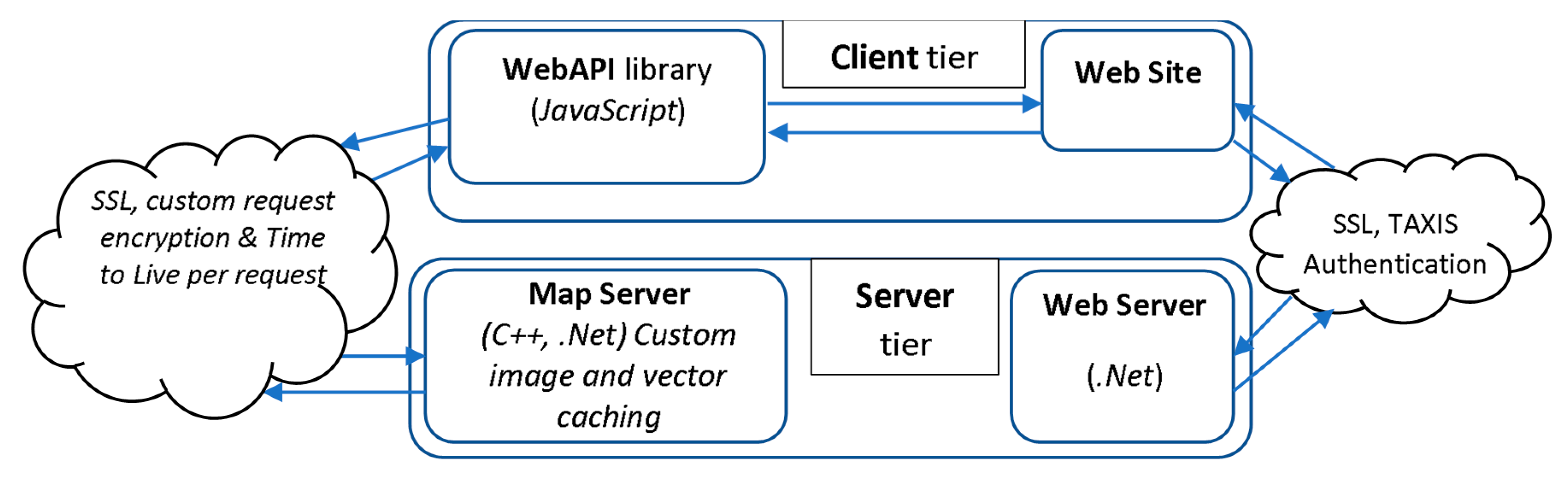
To address the aforementioned issues, a new system was built from scratch specifically designed to resolve these problems. The new system introduced two tiers: a server tier and a client tier.
The client tier is a new JavaScript library API named (WebAPI), similar to openLayers or Google Maps, in terms of functionality and usage that was created from scratch. WebAPI is responsible for creating encrypted, per user, requests to the server tier and receiving bulk proprietary data. To support thousands of concurrent users, the WebAPI is designed to accept the bulk data and use the clients’ CPU power to de-cypher and portray the results for both 2D and 3D terrain presentations. Using client-side rendering mechanisms, the server tier load is mitigated to the clients thus allowing many more users than what the current COTS or Open Source software allow when installed on the same hardware.
Furthermore, WebAPI uses proprietary mixed vector-image caching mechanisms to relieve the server load and transfer the processing to the client. The main idea behind the vector caching was that the whole jurisdiction of Greece was divided into a grid with a square block side of about 1.4 km. Each time vector data is updated, something that happens frequently, the system caches, in a proprietary vector format, the affected blocks. Caching duration is normally a matter of a few seconds up to a few minutes, according to the size of the affected area. For small scales (1:20,000 and lower), image caches are created again within a few seconds up to a few minutes. The WebAPI introduced the idea of mixed vector-raster caching and it can handle it automatically for all scales. If a user works at a small scale, then the raster caching will be activated, otherwise the vector caching will be activated with the WebAPI, filtering the displayed results based on bulk blocks.
Since this WebAPI is designed to offload the server utilization, the existing server-side hardware can support many more users simultaneously. In fact, the WebAPI initiated a “handshake” with the server, upon connection, exchanging unique key information in an encrypted format. Each client request is then validated by the server and is served only for the specific user. If the same user repeats the same request after one minute, the server will deny serving it in order to protect potential “trojan infections” (unauthorized access request). The WebAPI, along with the vector caching, use cached raster tiles as orthophotos for the various scales. When the user navigates on the orthophotomap, the WebAPI produces a proprietary user specific encrypted request for each tile and for each layer.
The server-side tier is a custom-made map server built to feed the client-tier. The server is built using C++ and .Net and is deployed in windows servers.
The above mechanism allows increased traffic utilization, but it requires minimized server-side usage, and thus it has successfully served more than 3 billion tiles for more than 10 million visitors during 2019. An explanatory diagram is presented in
Figure 1.
5. Newly Introduced IT Services
5.1. New Online Cadastral Declaration Web Site
The new Cadastral Declaration Web Site (CDWS) started its operation at the beginning of February 2019. It is a great improvement over the previous service in terms of functionality, usability, endurability, interoperability, technology, and security. The e-declaration process is presented in
Figure 2.
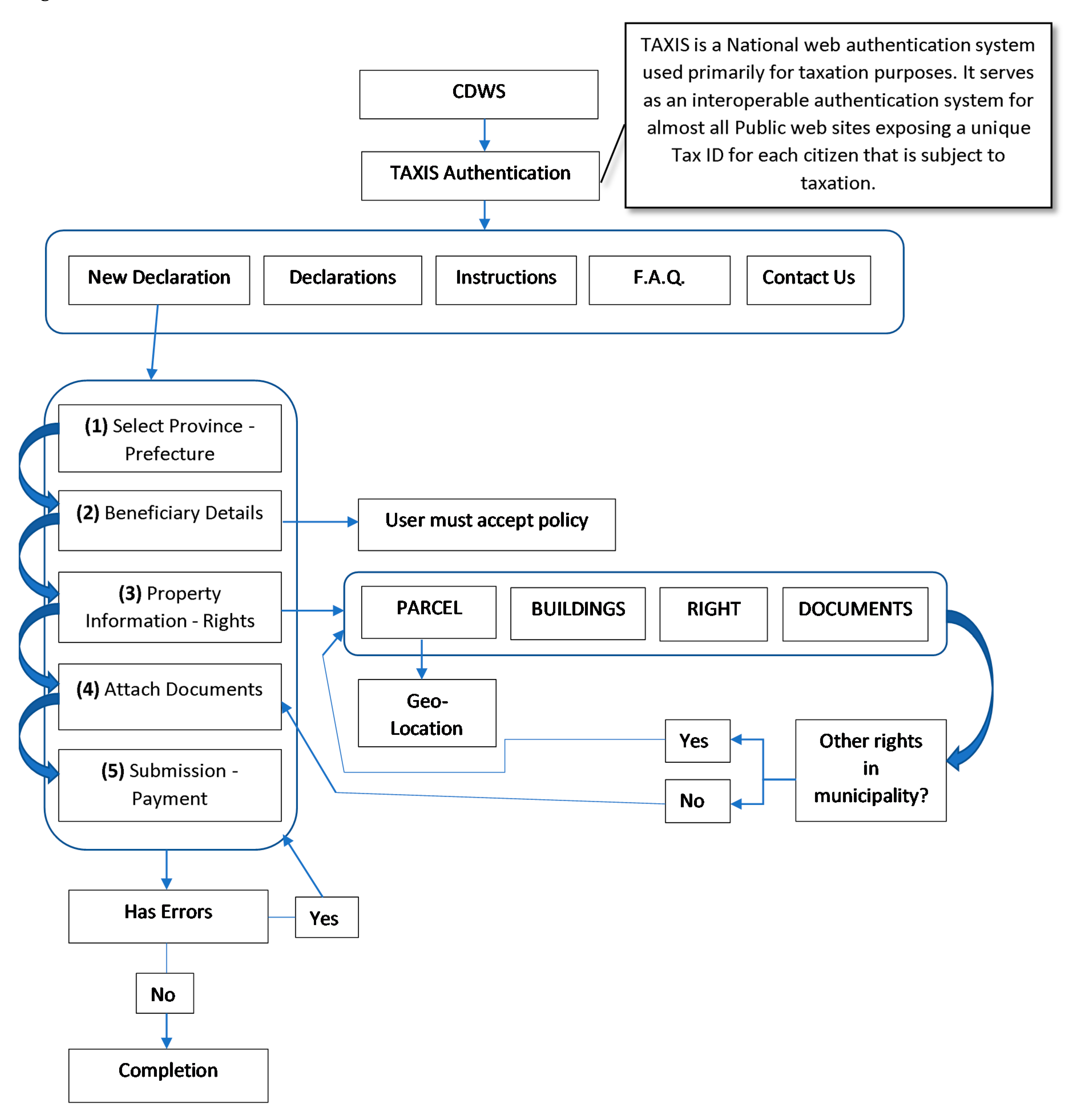
The CDWS utilizes the TAXIS authentication system, the system that keeps the Greek citizens’ records for taxation purposes. Within TAXIS, each citizen has a unique identification number, which identifies him/her as a person. Using the TAXIS credentials, the Cadastral Agency can directly identify the person without any further need for input. This way all the information collected by the Cadaster can later be used by the Ministry of Finance, or any other public service, for property valuation and taxation or other purposes.
Upon a successful login, the user can choose among three options: (a) declaring a new property, (b) viewing or editing previous declarations, or (c) reading the manual for communication by email with the support center.
Each property right must be declared separately by the following five distinct steps (
Figure 3). Each step should be completed in the order of appearance to provide the easiest and simplest process flow. There are steps that are linked in such a way that one is a prerequisite to another, as in the case of attaching documents to the declared rights, but in general, an experienced user could process each step separately where no prerequisites exist. Each step can be temporarily saved separately so that declaration can be continued at a later time.
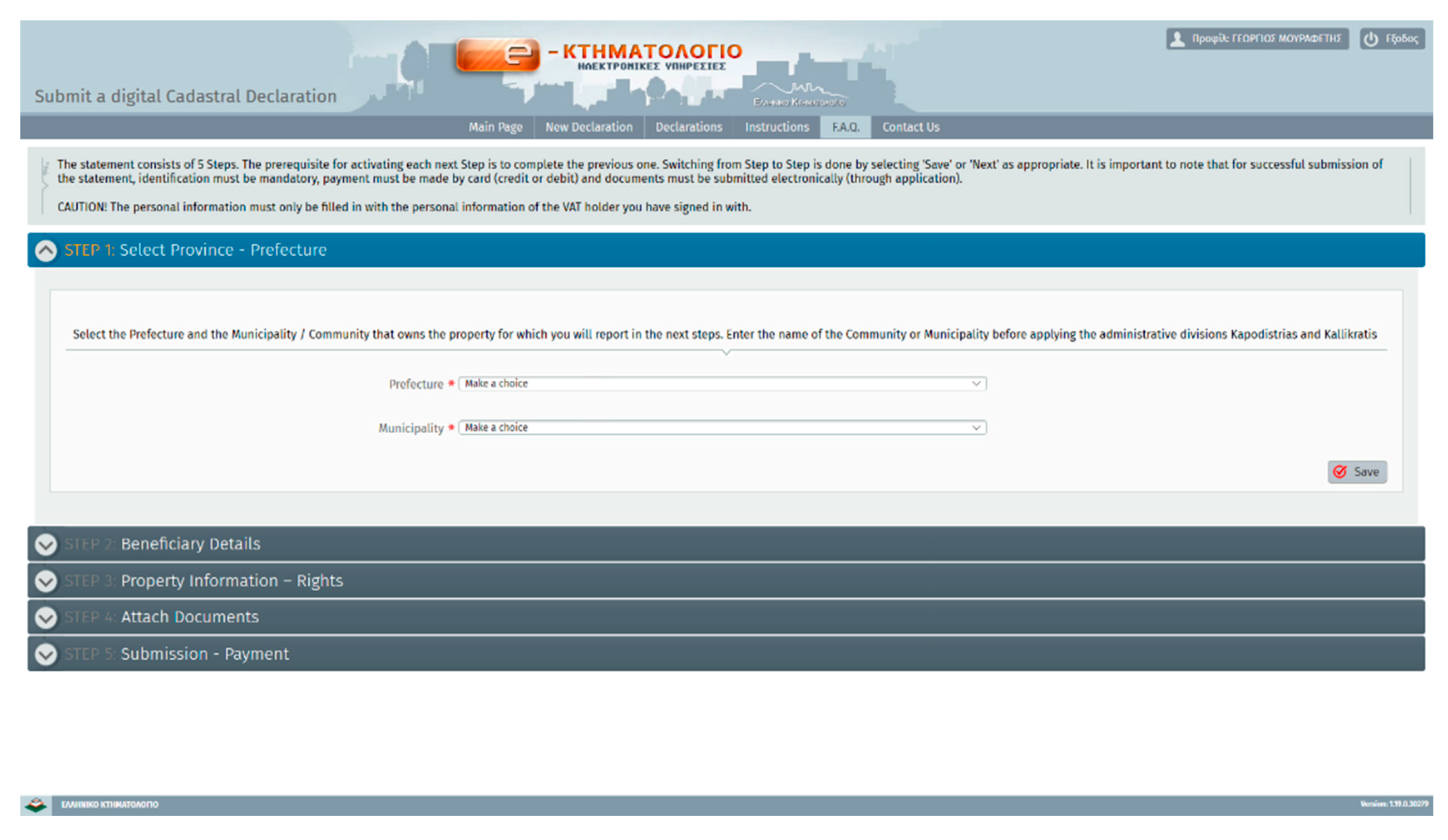
The first step of the declaration process refers to the choice of the province–prefecture and municipality in which the property right/parcel resides. This information will be cross-checked with the geo-located parcel at a later stage to ensure the correct location. The citizen must choose among the predefined values in two dropdown lists.
The second step of the declaration process is the declaration of the right holder’s personal data, such as full name, parent’s name, etc.; contact information is also asked, so that the right holder can be reached whenever needed. In case a property right is declared by a legal representative of the right holder, or through other means of representation, then all additional data should be declared, too, in this step. The users must confirm the validity of all information entered and allow the use of this information for the compilation of cadastre before continuing.
The third step is the most important one in the declaration process because it includes information about the actual property unit. Cadastral information about right holders and property rights are related to a particular 2D land parcel; each parcel takes a unique cadastral code number. This number shows information about the municipality unique code, the sector unique code, the block of plots unique code, and a unique plot/parcel number that increments within each block of plots. Once a land parcel is being developed (usually urban plots are developed), legal subdivisions of the land parcel/plot may also happen, and/or multi-story buildings with individual condos may be constructed. In such cases, new individual cadastral property units are created. Each individual property unit then takes a new unique cadastral code number; this code number makes this property unit individually transferable. The cadastral map though shows only the land parcels/plots and not the building footprints or the individual 3D property units that may exist within them. This 3D strata information is only stored as alphanumerical and not as graphical. Each property right must be declared separately. Thus, the right holder first should locate the land parcel on the map and declare all other information about the property unit, and the rights separately. The right holder in order to declare a property right must begin the process by first choosing (from a list) the type of property unit to which this particular property right referes. When the user choses a certain type of property unit, the system offers a different flow that includes only the required information based on that choice.
For example, the simplest type of a property unit is that of a land parcel/plot. In this case, the system will pop up a new window where the right holder can enter the respective information.
The declaration of a property right on a property unit, in general, requires four types of information:
Parcel geospatial location, area size, and usage (by choosing among predefined land-use types)
Buildings
Rights on the buildings and/or on the land parcel (and the percentage of them e.g., full ownership or co-ownership)
Relation of rights with the submitted legal documents/proofs
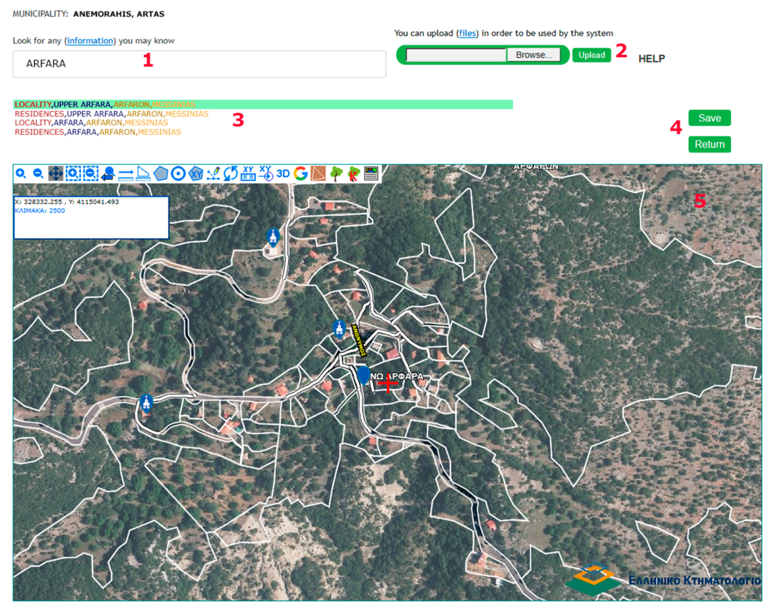
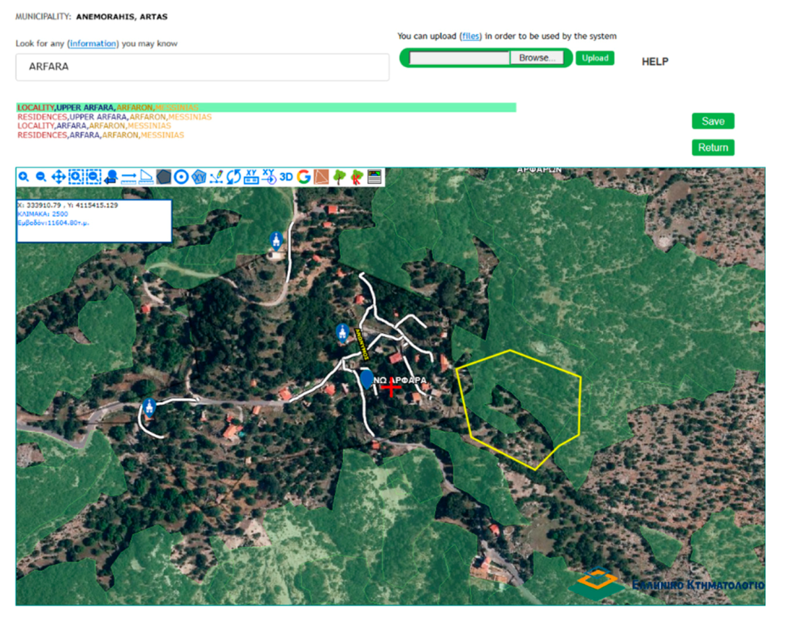
The most difficult process, for the user, is the geospatial-location of the land parcel, in which the property unit and property rights exist, on the orthophotomap. Following the filling of some basic information such as address, postal code, locality etc., the user must locate the property unit on a new window on the location service (LS) shown in
Figure 4.
Search (1) is possible by locality, street name, point of interest, postal code, rural or urban administrative distributions, agricultural subsidy, etc. The system will try to find the best matches and will present the information found (3). The user can then click on each match in order to be navigated to the corresponding location.
The contractor, responsible for the specific area, has already provided a draft set of predefined land parcels that are displayed on top of the orthophoto, using all existing information in public agencies such as municipalities, planning offices, forest agency, etc. If the user agrees with the predefined parcel, then a simple click on it is sufficient for the declaration. If the user does not agree with the draft predefined land parcel, they can either edit the predefined land parcel boundary or digitize a totally new land parcel. All the tools required for editing and digitization have been provided using the toolbar on the orthophotomap. The user can also upload a parcel in several predefined formats (dxf, csv, gml) (2).
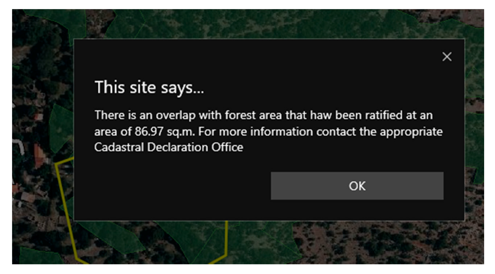
In parallel to the Hellenic Cadastre, another big project is close to completion in Greece, the compilation of Forest Maps. This information is vital to each right holder, especially in the non-urban areas, because if a specific land parcel unit resides within a “forested land”, then other complicated legal paths need to be followed that may even lead the right holder to completely lose interest in declaring the property right. According to legislation in Greece, forest and forested lands belong to the state unless there is a legal sequence of deeds/titles since 1884.
To help the users, the system will display either the final/ratified forest map (if existing) or the temporary/draft forest map as an overlay with the parcel declared (
Figure 5). When the user digitizes or uploads a land parcel, the system will check whether this is located within a forest polygon in a temporary or a final forest map. In this case, the system will present the area of overlap and suggest to the user to contact the cadastral office for further details (
Figure 6).
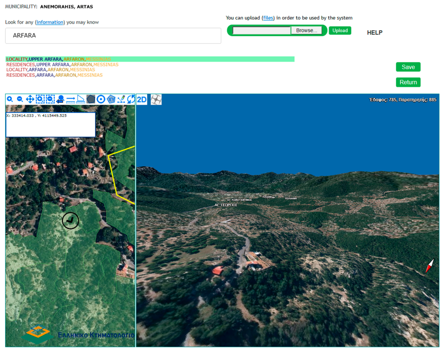
A high accuracy three-dimensional map of the area along with the two-dimensional map is available, so that the right holder can get a more realistic overview of the actual territory (
Figure 7), as presented in detail in [
36].
Once the right holder locates a parcel, the system will check if this resides within the minicipality boundaries selected in the first step. If not, it will ask the user to either change the selected municipality in the first step, or relocate the parcel within the correct municipality boundaries. That way, the gross errors detected in the previous cadastral phases of the Hellenic Cadastral project are now avoided. In the previous phases, right holders could not easily locate the land parcel on the orthophotomap, especially in the rural areas, due to similar patterns of olive trees, vineyards, or bushes [
10,
36]. Because of that, in some cases, parcels were declared in the wrong municiplities.
Following the successful location of the land parcel, other descriptive information such as buildings, if applicable, and other co-owners (if existing) should be declared. The type of property right being declared, such as full ownership, partial ownership, easment, confiscation, court decisions etc., must be chosen among predefined lists.
Each declared property right must be associated with one or more legal deeds/titles. The system has a very efficient and detailed flow based on the user interaction that will only allow valid entries per case. In case the property right must be associated with more than one legal document, the system will guide the user by allowing the repetition of the process. Each legal title has lots of metadata that must be filled out such as the type, creator, etc.
To make things simpler, the system will also ask the user whether he/she wishes to declare more property rights on more property units/parcels in the same municipality. Based on the answer, different flows will follow, allowing easy complition of the process.
In the simplest case, where the user only wishes to declare property rights on one property unit/parcel, the system will automatically correlate the declared rights to the declared legal documents without any further user interaction. If the user has more properties in the same municipality or the same land parcel, the process of associating each right with the respective legal documents must be followed.
The fourth step (as shown in
Figure 2) is about uploading the scanned documents according to the information entered in the previous steps. The system expects certain documents, based on the right-document associations that were created in previous steps.
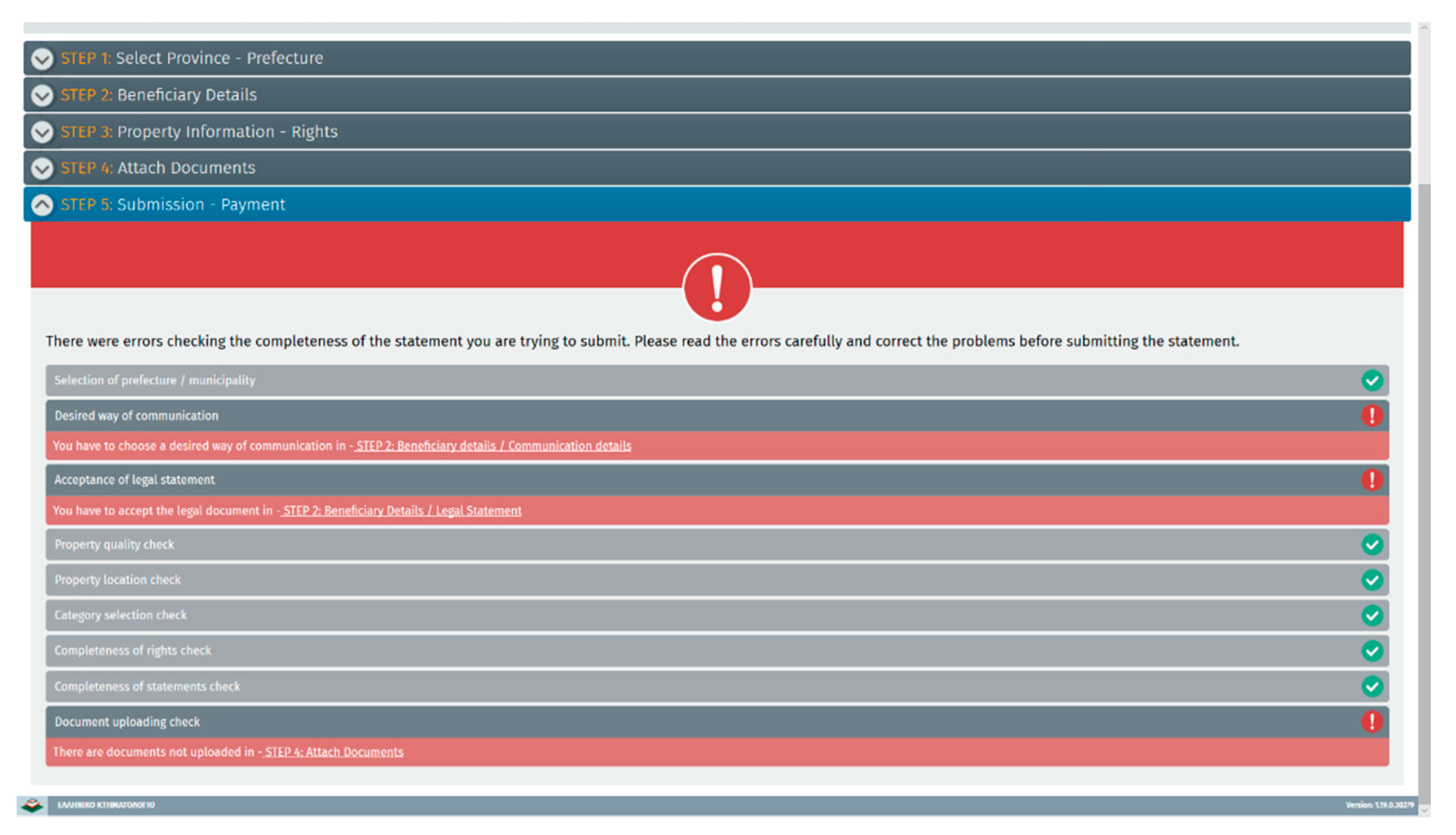
The fifth step is the final one. The system checks for the validity of all information declared and reports an error status (
Figure 8) if problems are detected. In the latter case, each step must be revised and corrected, based on the indicated errors, before submission of the declaration and online payment is allowed. After the whole process is completed, only “read only” access is permitted.
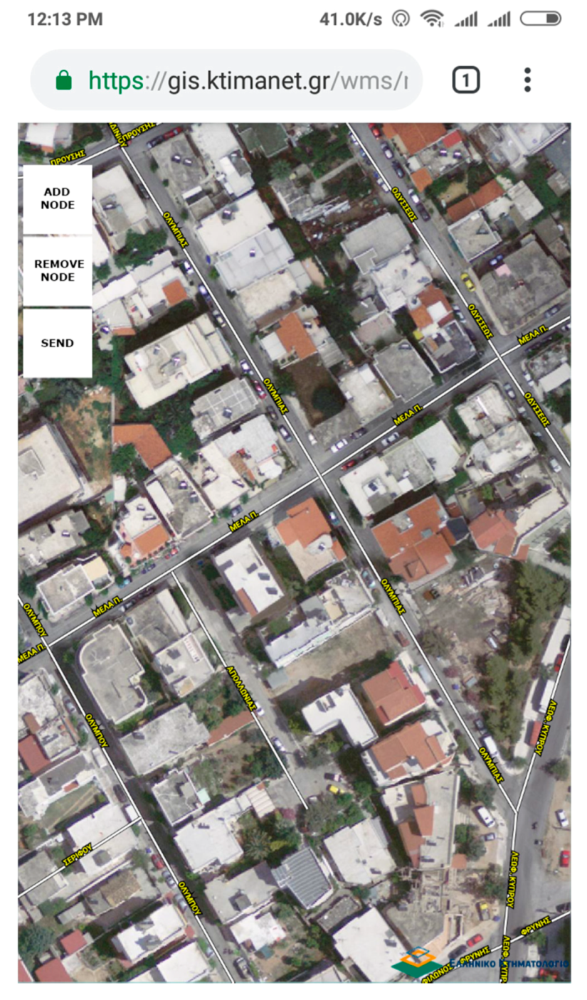
5.2. Property Unit Geo-Spatial Location with a Mobile Phone
To enable the right holders to locate their land parcels without the need of hiring a professional surveyor, a web application for GPS enabled mobile devices such smart phones was created. Every right holder can access this web applicaton, while on the field, and use it to record the land parcel boundaries of interest. These records can be uploaded in the location service providing the user with a draft boundary polygon. The user can use the recorded measurements as such or alter the boundaries to better match the accuracy of the basemap and continue with the declaration. The official basemap is an orthophotomap.
Upon visiting the web application, a valid email address must be provided. This address will be used by the system to send all recorded information. In conformance with GDPR directive Regulation (EU) 2016/679 [
37], the use of email for cadastral purposes must be accepted.
The web application will try to locate the mobile devices’ location with the highest possible accuracy and present its position on an orthophoto.
The user should stand steel for a few seconds on top of each point that needs to be measured before taking a measurement. Normally the points will be the nodes of the polygon of the land parcel being declared. The process should be repeated for each node. The map will continously move and center to the user’s position. Wrong measurements can be deleted. While the process is being repeated, the map will gradually draw the parcel’s boundary (
Figure 9).
When the digitization of the parcel boundary is completed, the user should complete the process by giving a friendly name, such as “granddad’s parcel” for the measurement to help distinguish more than one measurement.
The system will automatically create an email message that will include the following information:
An image with the outline of the land parcel on it
A csv file with the coordinates measured that can be used as input in area (2) in the LS
The friendly name that was given by the user for the specific measurement
A unique system identifier for the measurement
Each measurement is stored in the central database of the Hellenic Cadaster and includes the geometric accuracy information as declared by the mobile device. The measurements will be given to the contractors along with the unique identifiers in order to evaluate how reliable these measurements are based on their accuracy, and thus helping them produce more accurate boundaries.
6. Conclusions
Both of the above described focused IT services have already been in operation for more than eight months. Statistics from the previous cadastral phases indicated that online submission of declarations was less than 1% of the total declarations submission by the right holders.
So far the usage of modern and more focused IT services in the current phase shows that about one in every three declarations is being delivered over the internet. This percentage is impressive if we also consider the fact that the geospatial location of properties in the last phase of the program is far more difficult since it mainly involves rural properties difficult to be recognized due to similar land-use patterns.
During the declaration period, professionals such as surveyors were so busy supporting property owners through the process that it literally became a bottleneck. Many citizens were forced to locate the properties by themselves either on the basemap or by using a GPS enabled mobile device, because the response time of the professionals was not fast enough to meet the deadlines. Because of the large demand and lack of existing man power, other professionals, that were not previously involved in Cadastre related processes, such as civil engineers, were used by property onwers.
Various professionals, such as surveyors, engineers, architects, and many others including even tax accountants, have been staunch supporters of these services as they can earn money helping the right holders with the declaration submission from their offices; their personal data are not recorded though. Usage statistics indicate that many right holders as well, far more than the previous generations, used the services by themselves, without getting any professional support. Such statistics are not collected by the system though.
Up to January 2020, more than 1.1 million declarations have been submitted online from more than 750.000 right holders. About 1.8 million polygons have been entered online through the LS and more than 76.800 points have been registered through the mobile service.
Mobile service usage was expected to be higher. As for the moment, it seems that most of the right holders have either digitized their properties in LS, or hired a professional to produce a survey map. Lack of proper advertising of such a service is also a problem since most of the right holders are still unaware of the existance of a mobile service for the geo-spatial location of land parcels.
Crowdsourcing in the cadastral surveying has been widely accepted by citizens producing positive media reports. Everyday communication between the help center and the users suggests that most people have questions rather on legal issues than on spatial/technical issues.
Beside the web applications developed solely for the cadastral declaration submission, the same technology described in chapter 4, was used to build another web application where everyone could use the service without the need for authorisation, digitize polygons, and produce extracts. Contractors, cadastral surveyors, and even some media have suggested to the right holders, that did not want or could not use the Internet to submit the declarations, to either provide a survey map of the parcel/plot or to try to deliniate the parcel boundaries using the aforementioned mobile web application. More than 1.7 million extracts were created that were most probably used to assist declarations in Cadastral offices, adding more value to the created web services.
Crowdsourcing methodology and its current implementation for the Hellenic Cadastre was a great success and fullfilled the expected goals. The tool created is being used to cover all spatial web aspects of all business processes of the Hellenic Cadastre, including Cadastre creation, Forest Maps ratification, Cadastre operation, and G2C services. The customer-oriented custom developed spatial services have been proven as stable, fast, and reliable in serving many people with much content.
The developed WebAPI is currently being shared with other public agencies supporting their needs and providing high efficiency and functionality at minimal costs while fullfilling National Security restrictions. WebAPI is currently evolving, through new versions, including new requests from the Hellenic Cadastre and from other agencies. The WebAPI will be used as part of the National Spatial Data Infrastructure (NSDI) as a way to deliver definitive spatial information for all public sector. WebAPI supports several OGC standards, such as WMS, making it very easy for usage along with any other Map Server Commercial or not. WebAPI is expected to expand its usage in the following years as more public sector agencies will be using it to share their spatial data in G2C or G2G services.


