Review

Geographic Information and Communication Technologies for Supporting Smallholder Agriculture and Climate Resilience

1
Humanitarian and Conflict Response Institute, University of Manchester, Ellen Wilkinson Building, Oxford Road, Manchester M13 9PL, UK
2
UWA School of Agriculture and Environment, University of Western Australia, Perth, WA 6009, Australia
3
School of Geography, Earth Science & Environment, University of the South Pacific, Suva, Fiji
4
School of Geosciences, University of Sydney, Sydney, NSW 2006, Australia
*
Author to whom correspondence should be addressed.
Submission received: 9 November 2018 / Revised: 4 December 2018 / Accepted: 5 December 2018 / Published: 10 December 2018
(This article belongs to the Special Issue Sustainable Agriculture for Climate Change Adaptation)

Abstract

:
Multiple factors constrain smallholder agriculture and farmers’ adaptive capacities under changing climates, including access to information to support context appropriate farm decision-making. Current approaches to geographic information dissemination to smallholders, such as the rural extension model, are limited, yet advancements in internet and communication technologies (ICTs) could help augment these processes through the provision of agricultural geographic information (AGI) directly to farmers. We analysed recent ICT initiatives for communicating climate and agriculture-related information to smallholders for improved livelihoods and climate change adaptation. Through the critical analysis of initiatives, we identified opportunities for the success of future AGI developments. We systematically examined 27 AGI initiatives reported in academic and grey literature (e.g., organisational databases). Important factors identified for the success of initiatives include affordability, language(s), community partnerships, user collaboration, high quality and locally-relevant information through low-tech platforms, organisational trust, clear business models, and adaptability. We propose initiatives should be better-targeted to deliver AGI to regions in most need of climate adaptation assistance, including SE Asia, the Pacific, and the Caribbean. Further assessment of the most effective technological approaches is needed. Initiatives should be independently assessed for evaluation of their uptake and success, and local communities should be better-incorporated into the development of AGI initiatives.

1. Introduction

The agricultural industry is supported by 500 million smallholder farms, responsible for approximately 56% of global agricultural production [1,2]. Smallholder farmers are increasingly resource-poor and confronted by challenges associated with climate change, natural disasters, resource availability and access, and food insecurity [1,3]. Global climatic changes are influencing crop growth and yield, water balances, input availability, and agricultural system management components [4], with ensuing impacts on farming practices [5,6,7]. Smallholders are faced with both long-term climate stressors and short-term shocks [8]. Geographic variability in climate impacts coupled with low levels of coping and adaptive capacity results in high levels of vulnerability for marginalised farmers [9,10,11]. Vulnerability varies geographically (often at very local levels). This arises from the complexity of smallholder livelihoods, with multiple on-farm/off-farm activities [12], variation in asset levels and market orientation [13], local (within-farm) variability in productivity [14], gendered roles and access to resources [15], and differential capacity to manage risk [16], affecting smallholder capacity to respond and adapt to climatic challenges.
Incorporating geographic components (i.e., locational properties) into information for climate adaptation is valuable for enhancing environmental decision-making in high risk sectors, such as agriculture. Rapid advancements in geographic information technologies (e.g., geographic information systems (GIS)) and the availability of geospatial data allow for sophisticated capture, analysis, storage, dissemination and access of information across space and time. Concurrently, advancements in information communication technologies (ICTs) (e.g., short message service (SMS); smartphones; Web 2.0), have further increased the usability of geographic information derived from a diversity of sources [17].
Note, while popularity in use of the term geospatial has grown (e.g., geospatial web [18]; geospatial semantics [19]), ambiguity remains over the difference between geospatial and geographic information. Geographic describes information with a reference to Earth’s surface and near-surface [20], and geospatial data has been defined as location properties (any descriptive information about the location or area of, and relationships among geographic features) related to any terrestrial feature/phenomena [21]. We adopt the term geographic information/data, despite much of the material reviewed employing the term geospatial. We consider geographic information to be any information to which location on the Earth is a relevant feature, including both explicit and implicit [22] locational data.
Geographic information used within the agriculture sector—here termed agricultural geographic information (AGI)—is increasingly available to smallholders, yet uptake is limited. Despite a range of geographic information types, such as remote sensing, household surveys, or climate/market reports, accessibility and/or availability is often not in useful/usable formats. Traditionally, information provision to smallholders in developing countries is provided via agricultural extension organisations through farmer field schools, innovation networks and farming associations [23]. However, resource constraints and the diverse needs of smallholders limit the flow of top-down information [24]. For example, resource constraints of agricultural extension staff have been identified as a challenge under climate change in the South Pacific [25] and the lack of transparency and connectivity a constraint to information delivery in India [26].
To this end, we suggest a different or complementary model to supply smallholders with information is necessary, whereby smallholders can harness AGI to make better-informed and cost-saving decisions [27]. Using ICTs to communicate with farmers directly offers a potential for AGI to enhance sustainable agriculture [28], particularly through resources provision for increasing climate resilience at multiple landscape scales [29]. For example, access to geographic information regarding which drought-resistant crops to plant, including when and how, may increase smallholders’ capacities to prepare for and withstand such long term climate stresses. Or, localised and context-specific weather forecasts delivered directly to farmers’ mobile phones may allow timely decisions and mitigating actions to be taken that reduce the impacts of storms on farming livelihoods. The World Bank, African Development Bank, and African union claim that the greatest opportunities for economic growth and poverty alleviation (in Africa) are provided by ICTs in the agriculture industry [30]. Yet, the evidence base for ICT and use of AGI to support adaptive capacity of smallholders is poorly documented [31]. Baumüller [32] argues that the potential use of ICTs, such as mobile services for smallholder agriculture remains largely unfulfilled. Consequently, here we review recent trends and approaches to utilising geographic information and ICTs for agriculture, and in particular, initiatives for communicating climate and other agriculture-related information to smallholder farmers for improved livelihood security, climate change adaptation and landscape resilience. Our aim is not only to contribute to rectifying the dearth of systematically documented and analysed uses of ICTs in smallholder agriculture, but also to uncover valuable lessons for the design and application of future AGI initiatives. We achieve this through a systematic review of multi-source literature to address the following research questions:
i.
What are the key challenges that AGI initiatives aim to address?
ii.
What technological approaches have been adopted to provide AGI to smallholder farmers?
iii.
Who are the target users of AGI initiatives and how have initiatives been adopted?
iv.
What are the factors promoting or limiting the success of AGI initiatives?
We acknowledge that earlier review works exist on related topics with similar aims and methods to those we present here. The Food and Agriculture Organisation of the United Nations (FAO) [33] reviewed a decade of ICT advancements with applications to agriculture and rural development presenting important findings, such as the significant influence of elements like quality partnerships and the digital divide on project success. But this report was largely descriptive and based on a narrow selection of projects and therefore lacks the analytical depth and rigour associated with our systematic review of AGI initiatives. The World Bank [34] also produced a report on ICT in agriculture, but a similar critique to above could be applied. Baumüller [32] systematically analysed the impact of various mobile services for smallholder agriculture, offering useful lessons for future service developments and an assessment of current shortcomings, including a lack of useful empirical evidence and limitations to current methodologies for evaluating project impact. Our work differs in that it is not constrained to examining only mobile services, but includes a broader range of ICTs used in AGI initiatives, and specifically considers delivery of information of a geographic nature. Duncombe [35] also analysed mobile phone use for agriculture in developing countries, and again, our work examines a more technologically-diverse breadth of AGI initiatives. Further, our work includes the review of AGI initiatives found and described in multiple sources, as opposed to reviews based on only practice-based literature (e.g., [34]) or academic research articles (e.g., [35]).
We first provide a brief background to geographic information and farmer information needs in agriculture, followed by a detailed methodology, presentation of results and discussion in relation to the stated research questions, with particular emphasis on lessons learned from examining a broad range of AGI initiatives. We conclude by identifying critical knowledge gaps and future opportunities.

2. Geographic Information in Agriculture

AGI encompasses a wide range of information types and can be provided through a similarly wide range of technologies. This includes any agricultural information provided through ICTs that has a geographic component, such as location-specific information delivered via SMS, telephone or the Internet, as well as geographic information produced through more sophisticated technological approaches, such as GIS mapping and spatial modelling. GIS technologies provide flexible spatially-explicit tools that support decision making for environmental and natural resource management [36]. Combined with remote sensing technologies, mapping, modelling and monitoring environmental change aids climate change adaptation and mitigation initiatives across the agriculture sector [37,38]. These technologies have contributed to advances in precision agriculture and improved crop management in commercial broad acre agriculture [39,40,41], yet AGI utilisation by smallholders remains limited. Reflecting on successes from other sectors, geographic information has been used to respond to natural disasters and increase community resilience across a range of environments [42,43], and resilience building in the agricultural sector, particularly in smallholder communities, has similar use potential. Such an aspiration aligns well with the concept of climate smart agriculture (CSA)—to increase food and livelihood security, and farming and landscape resilience [8,44,45]—but explicitly identifies smallholders’ needs for improved information access to enable better decision making for sustainable agriculture.

2.1. Information Needs of Smallholders

Smallholder farmers require diverse information to support their livelihoods, with development in the agriculture sector dependent on success in generating, sharing, and applying knowledge [1,46]. Information can be obtained from scientists, educators, advisors, policy makers, and informal networks and smallholders themselves [31]. Information needs differ between farmers based on multiple factors, including socio-economic circumstance, literacy levels, access to resources, size of landholding, and agroclimatic conditions [28]. These factors, in conjunction with a range of socio-political conditions, such as governance structures, cultural norms and gender roles, influence how different individuals obtain and seek (applicable) information (e.g., [47]).

2.1.1. Information Availability

Availability of appropriate climate change adaptation information for smallholders often varies by geography and culture. For example, public media and personal experience form dominant information sources amongst Vietnamese farmers [48]. Conversely, in India, farmers rely on external experts such as non-governmental agricultural research for advice, despite their long histories of traditional knowledge [49]. Less formal agricultural knowledge transfer takes place through face-to-face interactions and verbal communication via mobile phones in rural communities [49]. Television, radio, agriculture offices/departments, neighbours and progressive farmers provide the most useful information sources, at least in part due to exposure and availability [50]. Further, the availability of precise and timely weather-based agro-advisory messages are useful in making informed and cost-saving decisions regarding cultivation conditions [27].

2.1.2. Information Accessibility

Information is commonly delivered to farmers through agriculture extension and advisory services [23]. Primarily top-down approaches, these transfer technologies, skills and knowledge to rural farmers and families to enhance crop/livestock production systems, household food security, and livelihoods, through increasing incomes, nutrition, education, and strengthening natural resource management [3]. However, several deficiencies of extension systems restrict their effectiveness, including limited staff, rigid organisation, poor capacity, a top-down linear culture, weak links to the research sector, and limited reach to farmers [28]. In India, for example, there are many [often duplicate] extension systems, yet the majority of farmers still suffer from inadequate information access [28]. Compounding these issues, women in rural communities bear considerable proportions of farming workloads, but have limited roles in receiving information and making decisions (see [27]). Women are often poorer with less land ownership and have difficulty accessing agricultural information from sources aside from other farmers [51]. Munyna [52] argues that women being ill-informed about technologies, markets, and other agriculture information is detrimental to agricultural development.

2.1.3. Information Applicability
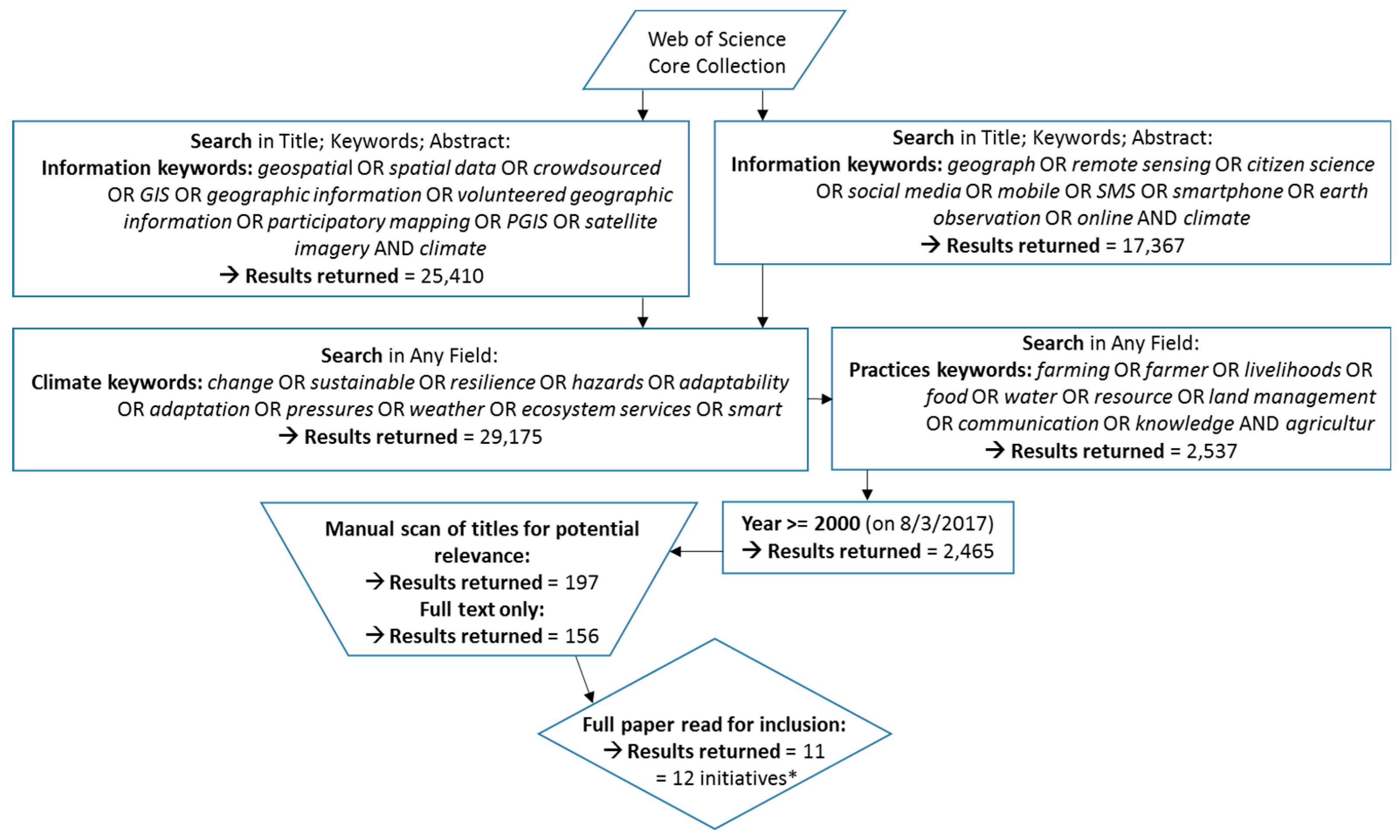
Scale of agricultural systems can influence who has access to [relevant] information. For example, national information produced at the government level may not be effective for improving farming practices at more localised scales. At the local scale, farmer field schools are a variation of extension services. Small groups of farmers routinely gather to observe and evaluate potential suitability of agricultural interventions for their farms [53]. This approach also builds social capital, but often exhibits fiscal limitations [54]. Researchers have argued for an increased emphasis on local rather than global initiatives in developing countries with improved relevance and applicability of information (see [55]). This includes the exchange of knowledge in appropriate formats that respect the oral traditions of many indigenous cultures [56].

3. Methodology

To identify AGI initiatives for analysis, literature was assessed from (i) peer-reviewed academic journals, and (ii) projects listed elsewhere or in grey literature, such as through government/non-government organisation, and other key development organisations and/or private sector agency databases. Assessing academic literature involved multiple keyword searches of the Web of Science Core Collection database, which focused on the topic areas of information, climate, and agriculture practices (in that hierarchical order) (Figure 1). Articles were constrained to include only current or recent literature (published after the year 2000; the time period considered to represent the growth of relevant geographic information, the internet, and other ICTs; when mobile technology penetration rates began to expand in developing countries [32]), those published in English language, and only items with full-text versions available. We acknowledge relevant literature will also exist in other languages, such as French, Spanish, Mandarin, or Hindi, among others, and hence incapacity to analyse non-English sources is a limitation of this study [57]. Articles which met all criteria (n = 156) were read and either entered into a spreadsheet for summarisation and analysis, or discarded if deemed not relevant. Assessment of relevance was made in relation to the research questions presented in Section 1. An article may have met all search criteria by using geographic information technologies to examine some aspect of improving agricultural practices in the context of climate change, but if the article did not describe initiatives specifically for communicating such information with farmers it was deemed not applicable to our research questions and thus was excluded. This process was performed initially by one author, and afterwards verified by another. Articles were also discarded if they only provided duplication (e.g., multiple articles describing the same initiative).
Assessing grey literature involved identifying databases, sources, agencies, and other websites that may contain information on relevant community, agriculture and climate-related AGI initiatives. Where a database had a large number of initiatives, filtering based on keywords (in line with those presented in Figure 1) produced a subset which was manually reviewed for inclusion in a database used for summarisation and analysis. Grey literature assessment was inherently less systematic and could not be automated, and we note the limitation to findings for inclusion in this paper, as once a perceived cross-section of different types of initiatives was obtained the search was ceased. This resulted in 15 AGI initiatives identified. In total, 27 individual AGI initiatives were identified through the above scholarly and grey literature search methods (See Table 1). All initiatives were summarised and analysed in a spreadsheet according to key information relevant for answering the predefined research questions. This included descriptive information (such as initiative name, source, and year), target location and users, initiative aims and approach to achieving aims, climate-related challenges being addressed (short and long term), geographic technologies adopted, the participatory nature of each initiative, adoption and usage information, and details of if/how the initiative was evaluated and by whom.

4. Results

4.1. AGI Initiatives

Target users of the AGI initiatives and the key challenges they seek to address are reflected in the distribution of where implementation occurred (see Table 1 for name and summary description of each initiative). Initiatives were concentrated in the global south, particularly south Asia, and east/west Africa. India and Kenya were highlighted as individual countries with the highest numbers of initiatives reviewed. Initiatives largely targeted smallholder farmers and rural communities (n = 18). Some AGI initiatives specifically targeted women farmers (Tigo Kilimo), farmers with low education levels (Tigo Kilimo), fishing households (Radio Monsoon), and progressive farmers more receptive to new technologies and practices (IFFCO Kisan Agriculture App). These target user groups are synonymous with those of more traditional approaches to agricultural extension and advisory services [3]. Other target users included scientists (e.g., PMDRRLK), governments (Smartscape), the agriculture extension community (WATMIS), NGOs and conservation organisations (Agriculture Monitoring System; Smartscape; LandCaRe DSS), risk management agencies (PMDRRLK), and the private sector (Agriculture Monitoring System).
Almost all initiatives adopted a top-down approach (n = 23), with only a few employing bottom-up practices (Digital Green, PMDRRLK and CROPROTECT). Greater emphasis was on communicating AGI to farmers, or providing a service that farmers can receive information from, rather than working with farmers to utilise AGI to support livelihoods. Of the initiatives adopting a bottom-up approach, Digital Green identified ‘champions’ from a local community to film and edit videos on new farming practices and topics, such as health (outputs were in local languages and topic selections were informed by scientists). Videos were then screened regularly in the community to share learnings. The localised participatory nature of Digital Green was important for people to relate to AGI information and increased adoption of sustainable livelihood practices throughout the community. IFFCO directly targeted progressive farmers, or those more likely to trial and adopt new practices based on capacity, circumstance, and interest. This assumed that farmers who receive AGI through the app, and adopt new practices, will then influence others in the community, either directly through sharing learnings or indirectly through demonstrated success.

4.1.1. Agro-Climatic Challenges Being Addressed

Many initiatives addressed climate adaptation of farmers through increasing livelihood security (n = 19), with some initiatives specifically aiming to increase household income or food security (n = 15). Several initiatives focus on addressing both long-term and short-term climate change to combat adverse impacts on livelihoods [53] and agricultural productivity [60]. In Kenya, where rainfed agriculture supports the majority of subsistence livelihoods, ITIKI sought to address the challenge of limited rainfall monitoring through the development of an integrated communication framework for indigenous knowledge and scientific drought forecast information. In Tunisia, issues of agricultural water wastage and mal-management of resources were being addressed by WSN-DSS, supporting farmers with weather information, improved irrigation scheduling and water management. In rural Africa, MSIAF aimed to mitigate the long-term stress of drought by alerting farmers to market locations to purchase drought-tolerant beans. Initiatives addressing short-term climate shocks were largely related to weather variability, including increased frequency and intensity of meteorological natural disasters (PMDRRLK; WAMIS; iska; Digital Green), extreme conditions like hailstorms and unseasonal rains (Sowing Application), and erratic weather (Radio Monsoon; (M)obile Solutions).

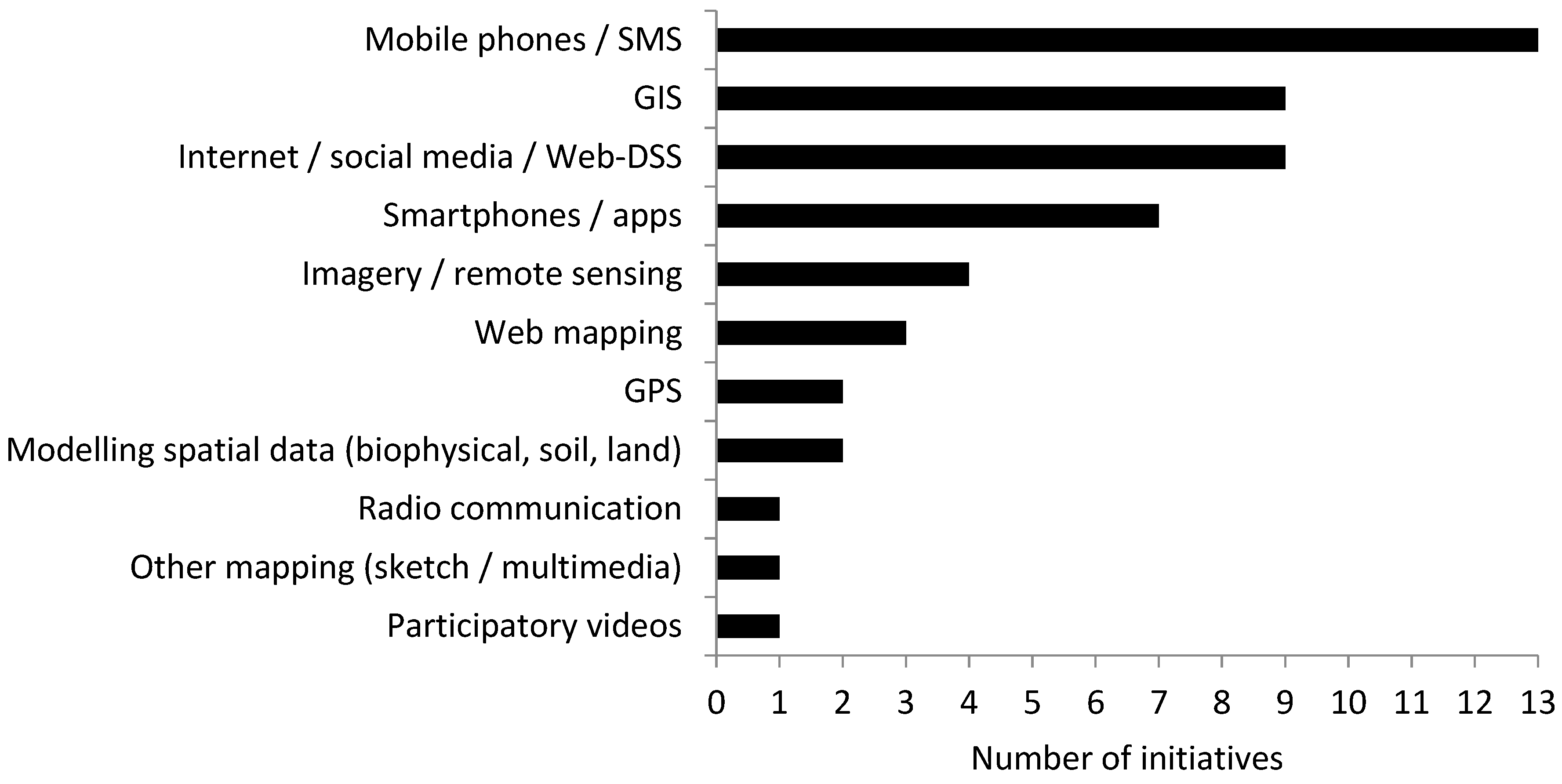
4.1.2. Technological Provisioning to Smallholder Farmers

Various technologies were utilised in the AGI initiatives (Figure 2). MMIS, Tigo Kilimo, Airtel Kilimo, (M)obile Solutions, and FDSS provided simple weather, crop or market information to farmers via low-tech tools, such as SMS and mobile phones, whereby farmers could either receive automatic updates (push notifications) or request information through SMS request or calling a helpline. Varying degrees of complexity were built into these basic mobile phone-based solutions. The inclusion of multiple languages and a peer-to-peer chat function were provided in the Airtel Kilimo mobile service. iska harnessed GPS technology to provide location-specific weather information via SMS. Other AGI initiatives employed internet capabilities to develop custom platforms and smartphone applications, expanding the possible information services offered in terms of both content and format, including support of images, video, animation, interactive content and maps, and hyperlinks to additional online resources. Jayalaxmi Agro Tech offered a range of crop-specific smartphone applications that aimed to enhance food and livelihood security by providing text, audio and visual content on crop information, pricing analytics, and on-demand weather to farmers in English and local languages. Similarly, IFFCO Kisan Agriculture App and Sowing Application aided farmer decision making through the provision of crop or weather information through text, voice, photo and video content. Plantwise Knowledge Bank used smartphones to augment their community-based information exchange activities by pooling information into a central resource for farmers and stakeholders to access; this is particularly useful for remote access by individuals. While GPS was explicitly stated for few AGI initiatives (WATMIS; iska; Agriculture Monitoring System), other initiatives using smart devices likely exploited this technology to provide their locational services.
Some web-based platform initiatives included and disseminated more data-rich geographic information, such as fine resolution satellite imagery e.g., WATMIS and Agriculture Monitoring System. Satellite imagery and other forms of remote sensing are valuable for detailed depictions of landscape environments and remote capture of data [82]. In Afghanistan, experimentation with methods of classifying satellite imagery was undertaken to strengthen national capacity on rice crop monitoring for sustainable development and food security (GIRCM). WATMIS incorporated GIS and remote sensing data for viable and cost-effective integrated watershed and natural resource planning and management, used by agriculturalists, rural communities and extension services, and land managers. Many AGI initiatives used GIS in combination with ICTs to increase landscape resilience. For example, environmental mapping of drought extent, soils and crops were disseminated to extension workers and farmers, through mobile phones (MSIAF). Online capabilities of technologies have allowed user feedback and sharing of local knowledge for a range of applications, in particular, through social media and crowdsourcing platforms [17]. Radio Monsoon included social media through multiple AGI dissemination methods, and participatory mapping activities that harness local knowledge were used in PMDRRLK. Aside from these two initiatives, social media was absent in all other initiatives. More traditional and primitive forms of information communication, such as radio, loudspeakers and billboards in communities were utilised in some initiatives (e.g., Radio Monsoon; ITIKI).

4.1.3. Adoption of Initiatives

Our review identified limited details of AGI initiative adoption details, with a number being at the proposal, pilot or development stage (n = 10). For those with uptake statistics, assessments of adoption were complex. While the number of users or downloads (e.g., of a smartphone application) of an initiative seemed a standard measure of uptake, more nuanced patterns and differences between numbers of downloads, active users, repeat users, and those who implemented changes to their livelihood practices were also observed. Tigo Kilimo reported 400,000 registered users in two years. Of these, 61% were repeat users, with many trialling the service once but not returning. 30% of users reported continued use with concurrent use of new agricultural practices or growing new crops more likely. 39% were more likely to experience increased income than those not engaging with the service. An analogous service, Airtel Kilimo, reported similar adoption patterns, observing 6432 of their total 22,438 registered users (December 2014) as active, with approximately 50% of users implementing farming changes. IFFCO Kisan Agriculture App reported 170,000 users (October 2016), of which 10–20% were estimated to be active. Iska self-reported to have reached more than 80,000 farmers [70] and sent more than 8.5 million weather forecasts [71]. However, no data were provided on how farmers benefited from this service, or how weather forecasts improved livelihoods and were received/read. Digital Green claimed to have reached one million individuals across 13,592 villages through their participatory video approach, with 574,222 farmers adopting at least one of the best-practice video promotions. Yet, similar to iska, no data were available regarding individuals that have/have not implemented new practices, and why uptake has/has not occurred.

4.2. Factors Promoting or Limiting AGI Success

Given the results of the initiatives reviewed, four cross-cutting themes emerged which are important for promoting or limiting the success of AGI initiatives for climate change adaptation: Farmer capacity, delivery approach, technology used, and the organisation delivering the information (summarised in Table 2).

4.2.1. Farmer Capacity

The most sophisticated AGI initiatives may be ineffective if target users are unable to access or utilise the information. Various socio-economic factors potentially limit accessibility for smallholder farmers, e.g., the level of disposable income required to acquire and/or access technologies like the internet, computers, smartphones, or televisions. Even relatively low-cost technologies like mobile phones may be inaccessible for many individuals, particularly in developing nations [83]. Consequently, poorer farmers are disadvantaged with increased difficulty in accessing AGI, despite often being the most in need. With reference to increasing participation in CROPROTECT, Bruce [62] described a lessening of digital divides in recent years, but poorer minorities still may lack access to ICTs. Communication technologies for enhancing knowledge access are often most beneficial for younger and more highly educated individuals [49]. Conversely, Bojovic et al. [84] demonstrated a weakening of digital divides for online participation in climate adaptation with groups that are typically excluded appearing as active participants (e.g., older or uneducated individuals). The contrasting ability of geographic information and ICTs to disproportionately benefit those who have access could be exacerbated if existing socioeconomic divisions within and across communities become greater [85].
One measure to increase farmer capacity is to incorporate local and additional languages in AGI initiatives, to ensure the usefulness of information and geographic information reach to maximise farmers benefitted. Information services provided only in English, for example, reduce the capacity of farmers who have first/only language to access the information. Producing and providing content in local languages facilitates comprehension and immediate connection with the local community (see Digital Green; [63]). However, using a local language alone reduces opportunities to expand platform use into other populations/geographical areas. Provision of information in both local/regional and national/international languages increases the probability of meeting a target user’s preference [59]. Projects incorporating detailed information in multiple languages relevant to the scale of operation, including regional and local dialects (e.g., Airtel Kilimo, Jayalaxmi Agro Tech, and Digital Green) are likely to exhibit improved information dissemination and utilisation.

4.2.2. Approach

Approaches with participatory elements offer multiple potential benefits over purely top-down approaches. Where individuals can share their own information with others and/or feedback with AGI initiative developers they may feel their input is more valued and subsequently more interconnected to build community resilience [86]. Partnering with existing community groups can be a useful approach to increasing community participation. Digital Green leveraged community groups, such as women’s self-help groups or farmers’ groups by actively partnering with government, non-government, and private agencies with strong integration and relationships with communities, and cites these partnerships as critical to their success. Whilst having users involved in initiative development is beneficial, requiring registration for participation is seen as a limiting factor. Registering and then subscribing to content causes confusion with some users and has deterred people from using AGI services ([59]; e.g., CROPROTECT).

4.2.3. Technological

A major consideration for the successful implementation of any AGI initiative is the availability and capacity of the information and telecommunications infrastructure. This includes infrastructure for capturing and disseminating information, and for farmers to receive and use it. For example, if an initiative requires high-speed internet access to deliver high-resolution images/videos, then internet coverage is essential, as is the accessibility of affordable internet-enabled devices and data plans. Similarly, if AGI initiatives are designed to include mechanisms for user participation and feedback, then necessary ICT functionalities are required to facilitate interactivity. Many of the reviewed initiatives emphasised the importance of low-tech, user-friendly technological platforms, especially for those with low digital literacy. Additionally, the information itself is important in AGI initiatives, particularly in relation to content, quality and scale. High quality and trustworthy, locally-relevant information is most useful; sourcing and compiling such data can be technologically-challenging for the success of AGI projects [59]. Jayalaxmi Agro Tech attempted to ensure information was relevant to users by developing multiple smartphone applications specific to individual crops and livestock, whereby farmers can select an app to receive only relevant advice to their own farming practices. Attention also needs to be paid to ensuring the security and privacy of users and the data they might supply to the system, particularly in approaches that encourage public participation.

4.2.4. Organisational

Organisational factors include the organisation responsible for developing and implementing the AGI initiative and the kind of support an initiative receives. Initial funding and ongoing financial capital for maintenance, management, and information sourcing are vital for AGI initiatives. Monetary uncertainty may result in premature cessation of an initiative. Funded by a university competition prize, Radio Monsoon was received very positively by village fisherman and the local forecasters. However, the initiative ceased after two years of operation, as funding was no longer available [76]. Many of the reviewed initiatives were developed by universities and funded by external grants/agencies which resulted in uncertain or short-term initiative lifespans (<5 years) and funding unpredictability. This is problematic for climate change adaptation as climate impacts and building livelihood resilience occur over longer timeframes and multiple generations. Programs that are supported financially and in-kind by multiple sources congruently, including through local and international partnerships with the private sector, government agencies, non-government bodies, and the research sector, such as FDSS, and with a clear business model to manage these funds, appear to have greater success and longevity through decreased pressures of financial insecurity.
Reaching and maintaining users is essential for the success of any AGI initiative. Product marketing is imperative to reach users of relevance, and to raise awareness of initiative existence and accessibility. IFFCO Kisan Agriculture App utilised an existing mobile phone service with relevant potential users to target uptake. Search engine optimisation and social media sites can also provide effective and affordable marketing tools [67], but accessibility to these technologies and services is reflective of farmer socio-economic development levels. The IFFCO Kisan Agriculture App social media marketing strategy was augmented by the addition of local celebrity endorsements. GSMA [59] describe marketing and user retention challenges linked to brand identity and loyalty. Airtel Kilimo is provided to farmers through Kenyan mobile network provider Airtel, and multiple ownership, name and brand changes of Airtel have negatively impacted customer loyalty, and thus initiative uptake. Conversely, good reputation and high organisational trust can foster the success of AGI initiatives through user loyalty, sharing of positive experiences and promotion to other farmers (e.g., Tigo Kilimo).

5. Future Potential of AGI

We reflect upon the results and cross-cutting themes discussed above to recommend future avenues for ensuring successful adoption of AGI initiatives by smallholders for climate change adaptation and mitigation.

5.1. Geographical Targeting

Observational factors (Table 2) suggest that both demand- (by the need for climate adaptation solutions) and opportunity- (by the growth of populations with functional access to required ICTs) driven AGI initiatives are important. Geographical targeting of regions currently not utilising AGI initiatives could substantially benefit smallholder farmers in areas highly impacted by changing climates. Regarding regions of high climate change vulnerability and areas predicted for severe climate impacts on agriculture, various reports identify South and Southeast Asia, Africa, Caribbean nations, and small island developing states (SIDS), such as Vanuatu, Samoa and Tonga (see [4,87,88,89]. Nations in some of these regions already have targeted AGI initiatives (e.g., India, Afghanistan, and parts of Africa), but many other global priority areas remain untargeted. Further research is needed to expound the reasons for these geographical gaps, and for smallholders in these countries to develop appropriate AGI strategies utilising either existing or new infrastructure, technologies, or platforms that will be most effective for the populations of those regions. Vulnerable climate regions generally coincide with areas of increasing access to ICTs, with fast-growing global internet penetration rates observed in Africa, the Middle East, Latin America, and Asia (2000–2017; [90]).

5.2. Types of Information and Information Technologies

Better understanding of the types of information and technologies that are most useful is needed to target users more effectively. A detailed SWOT (strengths, weaknesses, opportunities, threats) analysis of technologies would be valuable, specifically to determine which technological approaches would most effectively deliver AGI to smallholders impacted by digital divides, for example, impoverished and uneducated farmers, women, and those in regions where access to ICT is limited. Mobile phones and SMS can be especially useful technologies for communicating AGI to smallholder farmers as necessary infrastructure is often already present, and data requirements/costs are comparatively low; in many rural regions, mobile phones are often accessible for farmers where other technologies are limited [1,59]. However, credit costs and access to electricity for charging phones can prohibit farmers’ use of mobile technologies [83]. Additionally, the information disseminated via mobile phone may be limited by the text- or voice-only format. Technological, resource (cost), and skill components required to access and use AGI will present barriers for some farmers, which also impacts the inclusion of farmer feedback and local knowledge in initiatives. If technologies can be harnessed effectively, then community information sharing could promote greater peer learning and social connectedness, and contribute to increased community resilience [86].

5.3. Independent Assessment of Initiatives

Existing initiatives and future AGI projects should be independently assessed to provide robust success evaluations of their approaches. This is essential as current non-standardised, self-evaluative techniques provide no meaningful and comparable measures of AGI initiative effectiveness, and self-published usage statistics are often more aligned with marketing. The observed asymmetrical pattern of registered and active users is not unique to AGI initiatives, and transferability of assessment approaches by other online geographic information services could be investigated, e.g., OpenStreetMap has 0.5 million registered users (2011) with 38% having undertaken some mapping, and 5% classed as active contributors [91]. There is also a need to examine impacts for users with different characteristics (considering factors, such as gender, age, income, ethnicity, social status, religion and others), as usage and impacts will not be homogeneous among heterogeneous populations [32]. Furthermore, how project success is reported and marketed may have important implications for future funding and resource allocations, agriculture and climate policies, research and development directions, and the livelihoods of farmers. Thus, independent standardised approaches to evaluating AGI initiatives with an emphasis on more nuanced measures of success beyond simple user statistics are recommended. Moreover, the trust and collaboration often needed for farmers to adopt new practices and alternative ways of thinking takes time, and processes of social change can occur over generations [44], thus longitudinal assessments are also advised over raw user statistics.

5.4. Inclusivity for Multi-Level Stakeholder Communication

Ballantyne [31] argues the need for inclusive, participatory approaches to knowledge sharing, and to successfully use ICT to support farmers and rural communities, farming communities must be empowered to define their own needs. Public participation in GIS (e.g., participatory mapping by communities) to contribute their own unique spatial knowledge, often with support from government, nongovernmental, university and other organisations engaged in development and land-related planning [92], can develop community cohesion [93] and facilitate greater local engagement in land-related decision making [94]. Combining local knowledge on coping mechanisms with top-down strategies has enhanced the capacity of rural indigenous communities in SIDS to mitigate and withstand environmental pressures [95]. Additionally, enhancing smallholder social capital can provide opportunities for more effective articulation of individual and community goals/needs to policy makers, researchers and extension providers [3]. Challenges to inclusive AGI participation (e.g., education levels, household resources, local agro-ecological conditions, market access, availability of local producer organisations, and ability/willingness to collaborate and take risks) need careful consideration, particularly regarding equality for women [3]. Baumüller [32] reports for mobile services that study of behavioural factors impacting farmers’ capacity and willingness to participate and/or take risks is a significant research shortfall. Technologies that are adapted to smallholders’ capacity to take risks and integrated with relevant support services [28], especially to reach marginal farmers where traditional extension activities [3] or locations where reliability of traditional farming approaches [70] fall short, may prove useful in uptake of AGI to overcome cultural and socio-economic obstacles.
Underpinning each area of potential are important considerations and limitations to AGI that warrant further understanding. Adoption of AGI and any outcomes for smallholders are limited by the capacity to act on the knowledge or information gained. For example, a farmer may receive information of a locally-relevant drought-resistant crop, but may not have the financial means to acquire it. Capacity for decision making will also influence the success of AGI initiatives, and information provision alone may not result in meaningful change. Information accessibility is just one factor among many that significantly affect adaptation [96]. Improved comprehension is needed regarding how significant livelihood change occurs when farmers adopt AGI. This requires localised studies at the level of those users most affected (smallholder farmer communities). Further, as livelihood change is not a short-term process and may vary geographically, studies should be longitudinal and undertaken in a variety of climate-impacted regions. Significantly, the potential ability for AGI provision and adoption to address long-term systemic vulnerabilities requires further research attention.

6. Summary

Learning from past experiences and innovations to promote a successful climate adaptation and development research agenda for the future is crucial [97]. Under increasing livelihood pressures associated with short term, and long term, climate stressors, we advocate that smallholder farmers require diverse and locally-relevant geographic information to aid adaptation for increased food and livelihood security. As we identify, only a small percentage of targeted users of AGI initiatives we reviewed are using and acting on the information provided, which raises questions of the appropriateness of such approaches for addressing key agro-climatic challenges. Addressing these shortcomings is important for supporting smallholders to overcome global risks of extreme weather events, natural disasters, and failures of climate change mitigation and adaptation [98]. Our analysis has identified key recommendations that will serve as a valuable guide for the success of future AGI developments whereby knowledge gaps and implementation challenges should be addressed, particularly to align with the geographically varying needs of smallholder farmers (e.g., [99,100]. Use of AGI initiatives could greatly aid smallholders to move towards climate-smart agriculture [101] for sustainably increasing productivity [44], improving environmental livelihood security [102], and enhancing landscape resilience under a changing climate [103].

Author Contributions

Conceptualisation, B.T.H., J.D., E.B. (Eloise Biggs), B.B., E.B. (Eleanor Bruce) and N.W.; Methodology, B.T.H., J.D. and E.B. (Eloise Biggs); Validation, B.T.H. and E.B. (Eloise Biggs); Formal Analysis, B.T.H.; Investigation, B.T.H.; Resources, E.B. (Eloise Biggs) and B.B.; Writing—Original Draft Preparation, B.T.H.; Writing—Review and Editing, B.T.H., E.B. (Eloise Biggs), J.D., N.W., B.B. and E.B. (Eleanor Bruce); Visualisation, B.T.H. and E.B. (Eloise Biggs); Supervision, E.B. (Eloise Biggs), B.B. and E.B. (Eleanor Bruce); Project Administration, E.B. (Eloise Biggs), B.B. and E.B. (Eleanor Bruce); Funding Acquisition, E.B. (Eloise Biggs), B.B. E.B. (Eleanor Bruce) and J.D.

Funding

This research was funded under project ASEM-2016-30, an Australian Centre for International Agriculture Research (ACIAR) small research activity led by the University of Western Australia in collaboration with the University of Sydney and the University of the South Pacific.

Conflicts of Interest

The authors declare no conflict of interest.

References

  1. Sylvester, G. Success Stories on Information and Communication Technologies for Agriculture and Rural Development, 2nd ed.; Food and Agriculture Organization of the United Nations: Rome, Italy, 2015; Available online: http://www.fao.org/3/a-i4622e.pdf (accessed on 8 May 2017).
  2. Samberg, L.H.; Gerber, J.S.; Ramankutty, N.; Herrero, M.; West, P.C. Subnational distribution of average farm size and smallholder contributions to global food production. Environ. Res. Lett. 2016, 11, 124010. [Google Scholar] [CrossRef] [Green Version]
  3. Swanson, B. Global Review of Good Agricultural Extension and Advisory Service Practice; Food and Agriculture Organization of the United Nations: Rome, Italy, 2008. [Google Scholar]
  4. Knox, J.; Hess, T.; Daccache, A.; Wheeler, T. Climate change impacts on crop productivity in Africa and South Asia. Environ. Res. Lett. 2012, 7, 034032. [Google Scholar] [CrossRef] [Green Version]
  5. Coumou, D.; Rahmstorf, S. A decade of weather extremes. Nat. Clim. Chang. 2012, 2, 491–496. [Google Scholar] [CrossRef]
  6. Trenberth, K.E. Changes in precipitation with climate change. Clim. Res. 2011, 47, 123–138. [Google Scholar] [CrossRef] [Green Version]
  7. Lobell, D.; Schlenker, W.; Costa-Roberts, J. Climate trends and global crop production since 1980. Science 2011, 333, 616–620. [Google Scholar] [CrossRef] [PubMed]
  8. Hochman, Z.; Horan, H.; Reddy, D.R.; Sreenivas, G.; Tallapragada, C.; Adusumilli, R.; Gaydon, D.S.; Laing, A.; Kokic, P.; Singh, K.K.; et al. Smallholder farmers managing climate risk in India: 2. Is it climate-smart? Agric. Syst. 2017, 151, 61–72. [Google Scholar] [CrossRef]
  9. Thornton, P.K.; Lipper, L. How Does Climate Change Alter Agricultural Strategies to Support Food Security? IFPRI Discussion Paper 01340; IFPRI: Washington, DC, USA, 2013. [Google Scholar]
  10. Dow, K.; Berkhout, F.; Preston, B.L.; Klein, R.J.; Midgley, G.; Shaw, M.R. Limits to adaptation. Nat. Clim. Chang. 2013, 3, 305–307. [Google Scholar] [CrossRef]
  11. Jayaraman, T.; Murari, K. Climate change and agriculture: Future trends and implications for India. Rev. Agrar. Stud. 2014, 4, 1–49. [Google Scholar]
  12. Barrett, C.B.; Reardon, T.; Webb, P. Nonfarm income diversification and household livelihood strategies in rural Africa: Concepts, dynamics, and policy implications. Food Policy 2001, 26, 315–331. [Google Scholar] [CrossRef]
  13. Jayne, T.S.; Mather, D.; Mghenyi, E. Principal challenges confronting smallholder agriculture in Sub-Saharan Africa. World Dev. 2010, 38, 1384–1398. [Google Scholar] [CrossRef]
  14. Tittonell, P.; Giller, K.E. When yield gaps are poverty traps: The paradigm of ecological intensification in African smallholder agriculture. Field Crops Res. 2013, 143, 76–90. [Google Scholar] [CrossRef]
  15. Fisher, M.; Carr, E.R. The influence of gendered roles and responsibilities on the adoption of technologies that mitigate drought risk: The case of drought-tolerant maize seed in eastern Uganda. Glob. Environ. Chang. 2015, 35, 82–92. [Google Scholar] [CrossRef] [Green Version]
  16. Carter, M.R.; Little, P.D.; Mogues, T.; Negatu, W. Poverty traps and natural disasters in Ethiopia and Honduras. World Dev. 2007, 35, 835–856. [Google Scholar] [CrossRef]
  17. Goodchild, M.F. Citizens as sensors: The world of volunteered geography. GeoJournal 2007, 69, 211–221. [Google Scholar] [CrossRef]
  18. Elwood, S. Geographic information science: Emerging research on the societal implications of the geospatial web. Prog. Hum. Geogr. 2010, 34, 349–357. [Google Scholar] [CrossRef]
  19. Kuhn, W. Geospatial Semantics: Why, of What, and How. In Journal on Data Semantics III. Lecture Notes in Computer Science; Spaccapietra, S., Zimányi, E., Eds.; Springer: Berlin, Germany, 2005; Volume 3534. [Google Scholar]
  20. Longley, P.A.; Goodchild, M.F.; Maguire, D.J.; Rhind, D.W. Geographic Information Systems and Science, 2nd ed.; John Wiley and Sons Ltd.: Chichester, UK, 2006. [Google Scholar]
  21. Open Geospatial Consortium (OGC). Glossary of Terms—G. 2017. Available online: http://www.opengeospatial.org/ogc/glossary/g (accessed on 5 May 2017).
  22. Craglia, M.; Ostermann, F.; Spinsanti, L. Digital Earth from vision to practice: Making sense of citizen-generated content. Int. J. Digit. Earth 2012, 5, 398–416. [Google Scholar] [CrossRef]
  23. Benson, A.; Jafry, T. The state of agricultural extension: An overview and new caveats for the future. J. Agric. Educ. Ext. 2013, 19, 381–393. [Google Scholar] [CrossRef]
  24. Anderson, J.R.; Feder, G. Agricultural extension: Good intentions and hard realities. World Bank Res. Obs. 2004, 19, 41–60. [Google Scholar] [CrossRef]
  25. Taylor, M.; McGregor, A.; Dawson, B. Vulnerability of Pacific Island Agriculture and Forestry to Climate Change; Pacific Community: New Caledonia, 2016; Available online: https://spccfpstore1.blob.core.windows.net/digitallibrary-docs/files/6f/6fdef19c8085874a0406d7e1f64897bd.pdf?sv=2015-12-11andsr=bandsig=qUFufXOhh7WrD9g5SQuNcg89y1d4QUHTmUiUPqK0hEo%3Dandse=2018-05-20T04%3A14%3A47Zandsp=randrscc=public%2C%20max-age%3D864000%2C%20max-stale%3D86400andrsct=application%2Fpdfandrscd=inline%3B%20filename%3D%22Vulnerability_Pacific_agriculture_climate_change.pdf%22 (accessed on 12 December 2017).
  26. Duncan, J.M.; Tompkins, E.L.; Dash, J.; Tripathy, B. Resilience to hazards: Rice farmers in the Mahanadi Delta, India. Ecol. Soc. 2017, 22, 3. [Google Scholar] [CrossRef]
  27. Mittal, S. Role of Mobile Phone-enabled Climate Information Services in Gender-inclusive Agriculture. Gend. Technol. Dev. 2016, 20, 200–217. [Google Scholar] [CrossRef] [Green Version]
  28. Glendenning, C.J.; Babu, S.; Asenso-Okyere, K. Review of Agricultural Extension in India. IFPRI Discussion Paper 01048. International Food Policy Research Institute, 2010. Available online: http://cdm15738.contentdm.oclc.org/utils/getfile/collection/p15738coll2/id/7280/filename/7281.pdf (accessed on 16 June 2017).
  29. Balaghi, R.; Badjeck, M.C.; Bakari, D.; De Pauw, E.; De Wit, A.; Defourny, P.; Donato, S.; Gommes, R.; Jlibene, M.; Ravelo, A.C.; et al. Managing Climatic Risks for Enhanced Food Security: Key Information Capabilities. Procedia Environ. Sci. 2010, 1, 313–323. [Google Scholar] [CrossRef]
  30. Yonazi, E.; Kelly, T.; Halewood, N.; Blackman, C. eTransform Africa 2012: The Transformational Use of Information and Communication Technologies in Africa; World Bank, African Development Bank and African Union: Washington, DC, USA; Tunis, Tunisia, 2012. [Google Scholar]
  31. Ballantyne, P. Accessing, sharing and communicating agricultural information for development: Emerging trends and issues. Inf. Dev. 2009, 25, 260–271. [Google Scholar] [CrossRef]
  32. Baumüller, H. The little we know: An exploratory literature review on the utility of mobile phone-enabled services for smallholder farmers. J. Int. Dev. 2018, 30, 134–154. [Google Scholar] [CrossRef]
  33. Food and Agriculture Organization of the United Nations (FAO). e-Agriculture 10 Year Review Report; Food and Agriculture Organization of the United Nations: Rome, Italy, 2015. [Google Scholar]
  34. World Bank. ICT in Agriculture: Connecting Smallholders to Knowledge, Networks, and Institutions; World Bank: Washington, DC, USA, 2011. [Google Scholar]
  35. Duncombe, R. Mobile phones for agricultural and rural development: A literature review and suggestions for future research. Eur. J. Dev. Res. 2016, 28, 213–235. [Google Scholar] [CrossRef]
  36. Wang, J.; Chen, J.; Ju, W.; Li, M. IA-SDSS: A GIS-based land use decision support system with consideration of carbon sequestration. Environ. Model. Softw. 2010, 25, 539–553. [Google Scholar] [CrossRef]
  37. Adenle, A.A.; Azadi, H.; Arbiol, J. Global assessment of technological innovation for climate change adaptation and mitigation in developing world. J. Environ. Manag. 2015, 161, 261–275. [Google Scholar] [CrossRef]
  38. Kroschel, J.; Sporleder, M.; Tonnang, H.E.Z.; Juarez, H.; Carhuapoma, P.; Gonzales, J.C.; Simon, R. Predicting climate-change-caused changes in global temperature on potato tuber moth Phthorimaea operculella (Zeller) distribution and abundance using phenology modeling and GIS mapping. Agric. For. Meteorol. 2013, 170, 228–241. [Google Scholar] [CrossRef]
  39. Aubert, B.A.; Schroeder, A.; Grimaudo, J. IT as enabler of sustainable farming: An empirical analysis of farmers’ adoption decision of precision agriculture technology. Decis. Support Syst. 2012, 54, 510–520. [Google Scholar] [CrossRef]
  40. Bongiovanni, R.; Lowenberg-DeBoer, J. Precision agriculture and sustainability. Precis. Agric. 2004, 5, 359–387. [Google Scholar] [CrossRef]
  41. Zhang, N.; Runquist, E.; Schrock, M.; Havlin, J.; Kluitenburg, G.; Redulla, C. Making GIS a versatile analytical tool for research in precision farming. Comput. Electron. Agric. 1999, 22, 221–223. [Google Scholar] [CrossRef]
  42. Meier, P. Crisis mapping in action: How open source software and global volunteer networks are changing the world, one map at a time. J. Map Geogr. Libr. 2012, 8, 89–100. [Google Scholar] [CrossRef]
  43. Haworth, B.T.; Bruce, E.; Whittaker, J.; Read, R. The good, the bad, and the uncertain: Contributions of volunteered geographic information to community disaster resilience. Front. Earth Sci. 2018, 6, 183. [Google Scholar] [CrossRef]
  44. FAO. Climate-Smart Agriculture Sourcebook; FAO: Rome, Italy, 2013; Available online: http://www.fao.org/docrep/018/i3325e/i3325e00.htm (accessed on 4 December 2018).
  45. Thornton, P.K.; Aggarwal, P.; Parsons, D. Editorial: Prioritising climate-smart agricultural interventions at different scales. Agric. Syst. 2017, 151, 149–152. [Google Scholar] [CrossRef]
  46. World Bank. Enhancing Agricultural Innovation: How to Go beyond the Strengthening of Research Systems; World Bank: Washington, DC, USA, 2007; Available online: http://siteresources.worldbank.org/INTARD/Resources/EnhancingAgInnovationebook.pdf (accessed on 9 May 2017).
  47. Obayelu, A.; Ogunlade, I. Analysis of the uses of information communication technology (ICT) for gender empowerment and sustainable poverty alleviation in Nigeria. Int. J. Educ. Dev. Using ICT 2006, 2, 45–69. [Google Scholar]
  48. Dang, H.L.; Li, E.; Bruwer, J.; Nuberg, I. Farmers’ perceptions of climate variability and barriers to adaptation: Lessons learned from an exploratory study in Vietnam. Mitig. Adapt. Strateg. Glob. Chang. 2014, 19, 531–548. [Google Scholar] [CrossRef]
  49. Hudson, S.; Krogman, N.; Beckie, M. Social practices of knowledge mobilization for sustainable food production: Nutrition gardening and fish farming in the Kolli hills of India. Food Secur. 2016, 8, 523–533. [Google Scholar] [CrossRef]
  50. Kumar, K.R.; Nain, M.S.; Singh, R.; Bana, R.S. Analysis of farmers’ communication network and factors of knowledge regarding agro meteorological parameters. Indian J. Agric. Sci. 2015, 85, 1592–1596. [Google Scholar]
  51. Palmer, T.; Pshenichnaya, N. Tigo Kilimo Impact Evaluation; GSMA: London, UK, 2015; Available online: http://www.gsma.com/mobilefordevelopment/programme/magri/assessing-the-impact-of-tigo-kilimo (accessed on 15 August 2017).
  52. Munyna, H. Application of ICTs in Africa’s agricultural sector: A gender perspective. In Gender and the information revolution in Africa; Rathgeber, E.M., Adera, E.O., Eds.; International Development Research Centre: Ottawa, ON, Canada, 2000; pp. 85–124. [Google Scholar]
  53. Gandhi, R.; Veeraraghavan, R.; Toyama, K.; Ramprasad, V. Digital Green: Participatory video for agricultural extension. In Proceedings of the 2007 International Conference on Information and Communication Technologies and Development, Bangalore, India, 15–16 December 2007. [Google Scholar]
  54. Rola, A.C.; Quizon, J.B.; Jamias, S.B. Do Farmer Field School Graduates Retain and Share What They Learn? An Investigation in Iloilo, Philippines. J. Int. Agric. Ext. Educ. 2002, 5, 65–75. [Google Scholar] [CrossRef]
  55. Walsham, G.; Sahay, S. Research on information systems in developing countries: Current landscape and future prospects. Inf. Technol. Dev. 2006, 12, 7–24. [Google Scholar] [CrossRef]
  56. Metcalfe, M.; Joham, C. The “ear” and “eye” digital divide. In Organizational Information Systems in the Context of Globalization; Korpela, M., Montealegre, R., Poulymenakou, A., Eds.; Springer: Boston, MA, USA, 2003; pp. 419–434. [Google Scholar]
  57. Livoreil, B.; Glanville, J.; Haddaway, N.R.; Bayliss, H.; Bethel, A.; de la Chapelle, F.F.; Robalino, S.; Savilaakso, S.; Zhou, W.; Petrokofsky, G.; et al. Systematic searching for environmental evidence using multiple tools and sources. Environ. Evid. 2017, 6, 23. [Google Scholar] [CrossRef]
  58. FAO. Enhancing Agriculture Monitoring System Based on Geospatial Technology in Afghanistan. 2016. Available online: http://www.fao.org/3/a-i5569e.pdf (accessed on 15 August 2017).
  59. Groupe Spéciale Mobile Association (GSMA). Case Study: Airtel Kilimo, Kenya; GSMA: London, UK, 2015; Available online: http://www.gsma.com/mobilefordevelopment/wp-content/uploads/2015/02/GSMA_Case_Airtel_FinalProof02.pdf (accessed on 15 August 2017).
  60. Cole, S.; Fernando, A.N. Mobile’izing Agricultural Advice: Technology Adoption, Diffusion and Sustainability. Harvard Business School Working Paper. Cambridge, UK, April 2016. Available online: https://papers.ssrn.com/sol3/papers.cfm?abstract_id=2179008anddownload=yes (accessed on 10 October 2017).
  61. Girvetz, E.H.; Zganjar, C.; Raber, G.T.; Maurer, E.P.; Kareiva, P.; Lawler, J.L. Applied Climate-Change Analysis: The Climate Wizard Tool. PLoS ONE 2009, 4, e8320. [Google Scholar] [CrossRef] [PubMed]
  62. Bruce, T.J.A. The CROPROTECT project and wider opportunities to improve farm productivity through web- based knowledge exchange. Food Energy Secur. 2016, 5, 89–96. [Google Scholar] [CrossRef] [PubMed]
  63. Gandhi, R. Case Study 1: Digital Green: Leveraging social networks for agricultural extension. In Success Stories on Information and Communication Technologies for Agriculture and Rural Development, 2nd ed.; Sylvester, G., Ed.; Food and Agriculture Organization of the United Nations: Rome, Italy, 2015; Available online: http://www.fao.org/3/a-i4622e.pdf (accessed on 8 May 2017).
  64. Trogo, R.; Ebardaloza, J.B.; Sabido, D.J.; Bagtasa, G.; Tongson, E.; Balderama, O. SMS-based Smarter Agriculture Decision Support System for Yellow Corn Farmers in Isabela. In Proceedings of the IEEE Canada International Humanitarian Technology Conference (Ihtc2015), Ottawa, ON, Canada, 31 May–4 June 2015. [Google Scholar]
  65. GSMA. Farmforce; GSMA: London, UK, 2013; Available online: http://www.gsma.com/mobilefordevelopment/programme/magri/farmforce (accessed on 16 October 2017).
  66. FAO. Monitoring of Rice Crop Using Satellite Remote Sensing and GIS Technologies in Northern and Eastern Afghanistan. 2016. Available online: http://www.fao.org/3/a-i6146e.pdf (accessed on 22 August 2017).
  67. Darabian, N. Case Study IFFCO Kisan Agriculture App: Evolution to Data Driven Services in Agriculture. GSMA, London. 2016. Available online: http://www.gsma.com/mobilefordevelopment/programme/magri/iffco-kisan-agricultural-app-evolution-to-data-driven-services-in-agriculture (accessed on 15 August 2017).
  68. Masinde, M.; Bagula, A.; Muthama, N. Implementation Roadmap for Downscaling Drought Forecasts in Mbeere Using Itiki. In Proceedings of the 2013 Itu Kaleidoscope Academic Conference: Building Sustainable Communities (K-2013), Kyoto, Japan, 22–24 April 2013; pp. 63–70. [Google Scholar]
  69. Ignitia. Ignitia, Tropical Weather Forecasting. 2017. Available online: www.ignitia.se (accessed on 16 June 2017).
  70. United Nations Development Program (UNDP). Using SMS Texts to Provide Weather Forecasts for Small Farmers in West Africa. December 2015. Available online: http://www.undp.org/content/undp/en/home/presscenter/pressreleases/2015/12/22/using-sms-texts-to-provide-weather-forecasts-for-small-farmers-in-west-africa.html (accessed on 16 June 2017).
  71. Jayalaxmi Agro Tech. Welcome to Jayalaxmi Agro Tech. 2014. Available online: http://www.jayalaxmiagrotech.com/ (accessed on 21 August 2017).
  72. Wenkel, K.O.; Berg, M.; Mirschel, W.; Wieland, R.; Nendel, C.; Kostner, B. LandCaRe DSS—An interactive decision support system for climate change impact assessment and the analysis of potential agricultural land use adaptation strategies. J. Environ. Manag. 2013, 127, S168–S183. [Google Scholar] [CrossRef] [PubMed]
  73. Ogodo, O. African Farmers Get Geospatial Info on Their Phones. SciDevNet, 24 April 2009. Available online: http://www.scidev.net/global/farming/news/african-farmers-get-geospatial-info-on-their-phone.html (accessed on 19 August 2017).
  74. Laraki, J. Case Study 6: Mobile market information service: A pilot project of ICT use for smallholder farmers in Papua New Guinea. In Success Stories on Information and Communication Technologies for Agriculture and Rural Development, 2nd ed.; Sylvester, G., Ed.; Food and Agriculture Organization of the United Nations: Rome, Italy, 2015; Available online: http://www.fao.org/3/a-i4622e.pdf (accessed on 8 May 2017).
  75. Reichel, C.; Frömming, U.U. Participatory mapping of local disaster risk reduction knowledge: An example from Switzerland. Int. J. Disaster Risk Sci. 2014, 5, 41–54. [Google Scholar] [CrossRef]
  76. Slawson, N. Radio Monsoon attempts to ensure safety reigns among fisherman in south India. The Guardian, 24 April 2017. Available online: https://www.theguardian.com/global-development/2017/apr/24/radio-monsoon-safety-fishermen-south-india-kerala (accessed on 15 August 2017).
  77. Tayyebi, A.; Meehan, T.D.; Dischler, J.; Radloff, G.; Ferris, M.; Gratton, C. SmartScape™: A web-based decision support system for assessing the tradeoffs among multiple ecosystem services under crop-change scenarios. Comput. Electron. Agric. 2016, 121, 108–121. [Google Scholar] [CrossRef]
  78. Agarwal, V. New App Promises to Tell Indian Farmers When to Sow Crops. Available online: https://blogs.wsj.com/indiarealtime/2016/06/17/new-app-promises-to-tell-indian-farmers-when-to-sow-crops/ (accessed on 17 June 2016).
  79. Aher, P.D.; Adinarayana, J.; Gorantiwar, S.D.; Sawant, S.A. Information System for Integrated Watershed Management Using Remote Sensing and GIS. Remote Sens. Appl. Environ. Res. 2014, 17–34. [Google Scholar] [CrossRef]
  80. Aggarwal, P.K.; Baethegan, W.E.; Cooper, P.; Gommes, R.; Lee, B.; Meinkef, H.; Rathoreg, L.S.; Sivakumarh, M.V.K. Managing Climatic Risks to Combat Land Degradation and Enhance Food security: Key Information Needs. Procedia Environ. Sci. 2010, 1, 305–312. [Google Scholar] [CrossRef] [Green Version]
  81. Fourati, M.A.; Chebbi, W.; Kamoun, A. Development of a Web-based weather station for irrigation scheduling. In Proceedings of the 2014 Third IEEE Colloquium in Information Science and Technology, Tetouan, Morocco, 20–22 October 2014; pp. 37–41. [Google Scholar] [CrossRef]
  82. Lillesand, T.; Kiefer, R.W.; Chipman, J. Remote Sensing and Image Interpretation; John Wiley and Sons: New York, NY, USA, 2014. [Google Scholar]
  83. Duncan, J.M.; Haworth, B.; Biggs, E.; Boruff, B.; Wales, N.; Bruce, E. Managing multifunctional landscapes: Local insights from a Pacific Island country context. J. Environ. Manag. in review.
  84. Bojovic, D.; Bonzanigo, L.; Giupponi, C.; Maziotis, A. Online participation in climate change adaptation: A case study of agricultural adaptation measures in Northern Italy. J. Environ. Manag. 2015, 157, 8–19. [Google Scholar] [CrossRef]
  85. Haworth, B.T. Implications of Volunteered Geographic Information for Disaster Management and GIScience: A More Complex World of Volunteered Geography. Ann. Am. Assoc. Geogr. 2018, 108, 226–240. [Google Scholar] [CrossRef]
  86. Haworth, B.; Whittaker, J.; Bruce, E. Assessing the application and value of participatory mapping for community bushfire preparation. Appl. Geogr. 2016, 76, 115–127. [Google Scholar] [CrossRef]
  87. Wheeler, D. Quantifying Vulnerability to Climate Change: Implications for Adaptation Assistance; Center for Global Development Working Paper No. 240; Center for Global Development: Washington, DC, USA, 2011. [Google Scholar]
  88. Kreft, S.; Eckstein, D.; Dorsch, L.; Fischer, L. Global Climate Risk Index 2016: Who Suffers Most from Extreme Weather Events? Weather-Related Loss Events in 2014 and 1995 to 2014. Germanwatch Nord-Süd Initiative eV. 2015. Available online: https://germanwatch.org/fr/download/13503.pdf (accessed on 15 August 2017).
  89. Notre Dame Global Adaptation Initiative (NDGAI). Notre Dame Global Adaptation Index. 2017. Available online: http://index.gain.org (accessed on 14 August 2017).
  90. Internet Usage Statistics. Internet World Stats. N.p., 9 June 2017. Available online: http://www.internetworldstats.com/stats.htm (accessed on 12 June 2017).
  91. Neis, P.; Zipf, A. Analyzing the contributor activity of a volunteered geographic information project—The case of OpenStreetMap. Int. J. Geo-Inf. 2012, 1, 146–165. [Google Scholar] [CrossRef]
  92. IFAD. Good Practices in Participatory Mapping; Prepared by Corbett, J.M.; The International Fund for Agricultural Development: Rome, Italy, 2009. [Google Scholar]
  93. Corbett, J.M.; Keller, C.P. An analytical framework to examine empowerment associated with participatory geographic information systems (PGIS). Cartogr. Int. J. Geogr. Inf. Geovis. 2005, 40, 91–102. [Google Scholar] [CrossRef]
  94. Corbett, J. “I Don’t Come from Anywhere”: Exploring the Role of the Geoweb and Volunteered Geographic Information in Rediscovering a Sense of Place in a Dispersed Aboriginal Community. In Crowdsourcing Geographic Knowledge: Volunteered Geographic Information (VGI) in Theory and Practice; Sui, D.Z., Elwood, S., Goodchild, M.F., Eds.; Springer: Berlin, Germany, 2013; pp. 223–241. [Google Scholar]
  95. Mercer, J.; Dominey-Howes, D.; Kelman, I.; Lloyd, K. The potential for combining indigenous and western knowledge in reducing vulnerability to environmental hazards in small island developing states. Environ. Hazards 2007, 7, 245–256. [Google Scholar] [CrossRef]
  96. Menike, L.; Arachchi, K.K. Adaptation to climate change by smallholder farmers in rural communities: Evidence from Sri Lanka. Procedia Food Sci. 2016, 6, 282–292. [Google Scholar] [CrossRef]
  97. Jones, L.; Harvey, B.; Cochrane, L.; Cantin, B.; Conway, D.; Cornforth, R.J.; De Souza, K.; Kirbyshire, A. Designing the next generation of climate adaptation research or development. Reg. Environ. Chang. 2018, 18, 297–304. [Google Scholar] [CrossRef]
  98. World Economic Forum (WEF). The Global Risks Report 2017, 12th ed.; World Economic Forum: Geneva, Switzerland, 2017; Available online: http://reports.weforum.org/global-risks-2017/ (accessed on 14 August 2017).
  99. Harvey, C.A.; Saborio-Rodriguez, M.; Martinez-Rodriguez, M.R.; Viguera, B.; Chain-Guadarrama, A.; Vignola, R.; Alpizar, F. Climate change impacts and adaptation among smallholder farmers in Central America. Agric. Food Secur. 2018, 7, 57. [Google Scholar] [CrossRef]
  100. Abdul-Razak, M.; Kruse, S. The adaptive capacity of smallholder farmers to climate change in Northern Region of Ghana. Clim. Risk Manag. 2017, 17, 104–122. [Google Scholar] [CrossRef]
  101. Martinez-Baron, D.; Orjuela, G.; Renzoni, G.; Loboguerrero Rodriguez, A.M.; Prager, S.D. Small-scale farmers in a 1.5 °C future: The importance of local social dynamics as an enabling factor for implementation and scaling of climate-smart agriculture. Curr. Opin. Environ. Sustain. 2018, 31, 112–119. [Google Scholar] [CrossRef]
  102. Biggs, E.M.; Bruce, E.; Boruff, B.; Duncan, J.M.A.; Horsley, J.; Pauli, N.; McNeil, K.; Neef, A.; Van Ogtrop, F.; Curnow, J.; et al. Sustainable development and the water-energy-food nexus: A perspective on livelihoods. Environ. Sci. Policy 2015, 54, 389–397. [Google Scholar] [CrossRef]
  103. Kremen, C.; Merenlender, A.M. Landscapes that work for biodiversity and people. Science 2018, 362, eaau6020. [Google Scholar] [CrossRef] [PubMed]
Figure 1. Flow diagram for the academic literature search resulting in 11 relevant papers (12 agricultural geographic information (AGI) initiatives) for analysis (see Table 1 for sources). * One paper described multiple initiatives.
Climate 06 00097 g001
Figure 2. Technologies featured in reviewed AGI initiatives.
Climate 06 00097 g002
Table 1. All AGI initiatives identified for this review, including description, target locations and source.
InitiativeDescriptionTargeted Country or RegionSource
Agriculture Monitoring SystemAgriculture monitoring system and technologies for collecting, analysing, and disseminating information. Includes satellite remote sensing, GIS, and mobile GPS. Provides a knowledge base for government, NGOs, rural communities and other stakeholders that will aid sustainable land use and agriculture.Afghanistan[58]
Airtel KilimoMobile phone and SMS advisory service. Dissemination of information related to crops, weather and market prices for improved farmer livelihood security. Kenya[59]
Avaaj OtaloTop-down mobile phone advisory service. Delivery of weather, crop, fertiliser and other agriculture information to farmers. Addresses shortcomings of the extension system.India[60]
Climate Wizard ToolWeb-based system for climate change data analysis and mapping. Provides practical information for local and regional agriculture managers. Facilitates advanced statistical analyses for more technical users.Global[61]
CROPROTECTInternet and smartphone application utilising GIS and Google Earth. Knowledge exchange system for farmers to acquire and share information relating to pest, weed and disease management.United Kingdom[62]
Digital GreenParticipatory videos (local languages) used to involve local communities in sharing scientific agriculture information and local knowledge to improve livelihoods through better and more adaptive farming practices.India, Ghana, Ethiopia[53,63]
Farmer Decision Support System (FDSS)Advisory information for registered farmers via SMS to assist farming decisions e.g., when and how to plant, harvest, fertilise and manage crops. 7-day weather forecasts also provided. Philippines[64]
FarmforceSMS and smartphone application to link farmers with other actors in the agro-value chain to reduce transaction costs, aid compliance with food standards, and increase information exchange.Asia, Africa, Latin America[65]
Geospatial Information for Rice Crop Monitoring (GIRCM)Agriculture information derived from image classification and rice crop area estimation to enhance food security. Still in proposal stage.Afghanistan[66]
Indian Farmers Fertiliser Cooperative (IFFCO) Kisan Agriculture AppSmartphone application to provide crop information in various formats for enhanced decision making. Aimed at farmers who are receptive to new technologies and business approaches.India[67]
Information Technology and Indigenous Knowledge with Intelligence (ITIKI)Early warning system that integrates information from sensor networks and local knowledge on droughts. Communication using SMS, mobile phone calls, website posts, digital billboards and radio broadcasts to disseminate forecast information to farmers.Kenya, Sub-Saharan Africa[68]
iskaGPS-located weather forecasts (various time intervals) distributed via SMS to farmers to improve decision making and reduce weather-related crop losses.West Africa[69,70]
Jayalaxmi Agro TechCrop-specific smartphone applications for access to agriculture, horticulture and animal husbandry information (English and regional languages).India[71]
LandCaRe DSSSpatial simulation modelling to produce information for stakeholders and farmers involved in decision making related to land management and long-term impacts of climate change at regional and farm scales.Germany[72]
Mobile geospatial information for African farmers (MGIAF)Mobile phone alerts regarding purchasing of drought-tolerant crops for farmers in remote regions. GIS maps for extension officers and community development workers for information dissemination to farmers. Kenya[73]
Mobile market information service (MMIS)SMS request service for rural farmers to receive information on market information (e.g., product prices) to improve selling practices and decision making.Papua New Guinea[74]
Mobile soil information for African farmers (MSIAF)Web-mapping platform for providing soil information to farmers and government workers. Accessed via the internet or mobile phone. Kenya[73]
(M)obile SolutionsMobile phone voice and SMS messages (Hindi or a local language) sent to farmers. Contain information relating to weather, pests, seed varieties, climate change and climate-smart technologies. Provides recommended actions. Option for farmers to provide feedback to inform future messaging.India[27]
Participatory Mapping Disaster Risk Reduction Local Knowledge (PMDRRLK)Participatory approaches and co-produced mapping to improve local resilience to climate change related hazards and increase the use of local environmental knowledge. Switzerland[75]
Plantwise Knowledge BankOnline and smartphone-based knowledge bank with pest identification tools and factsheets on plant health to aid community farming.Global[62]
Radio MonsoonNational meteorological information and local knowledge for weather forecasts disseminated to fishermen via social media and the internet, landline and mobile phones, and loudspeakers positioned in fishing communities.India[76]
SmartScapeInternet and GIS tool to allow users to experiment with policy options, predict cropping system changes, and compare cropping scenarios. Produces information to be shared with stakeholders, such as policymakers, community agriculture groups, or non-government organisations.United States of America[77]
Sowing ApplicationSmartphone application and SMS used to advise registered farmers best times for sowing seeds based on soil health indicators and rainfall and weather information. Alerts issued for extreme weather conditions that may damage crops or impact farmers.India[78]
Tigo KilimoMobile phone dissemination of information on weather, crops and markets for enhanced decision making to improve food security, livelihoods and household income for farmers.Tanzania[51]
Watershed Management Information System (WATMIS)Web-based information and decision support system integrating soil, vegetation, climate and other environment information to assist agriculturalists, resource managers and the rural extension community in managing water scarcity.India[79]
World AgroMeteorological Information Service (WAMIS)Web-server for disseminating agrometeorological products and information bulletins. Provides knowledge and training to large numbers of agriculture stakeholders cost effectively via the internet.Global[80]
Wireless Sensor Network—Decision Support System (WSN-DSS)Wireless sensor network and web-based decision support system for irrigation scheduling. Supports farmers in restructuring agricultural land to address issues of food security and inefficient farming.Tunisia[81]
Table 2. Summary of factors promoting and limiting the success of AGI initiatives for addressing key agro-climatic challenges.
Factors Promoting SuccessFactors Limiting Success
Farmer capacityAffordability to farmersParticipation capacity (exclusion through gender, costs, digital divide)
Available languagesLimited languages
Information alone often not enough for meaningful change
ApproachPartnerships with existing community groupsMethods for incorporating community knowledge into GIS
User collaboration/sharingPurely top-down approach—lack of interactivity
Farmers involved in designUser registration required
TechnologicalHigh quality, locally-relevant informationAcquisition and sourcing of suitable and quality information/data
Low tech and user friendly—ease of useAvailability and capacity of telecommunications infrastructure
Allows participant feedback—interactivity functionalityPersonal and community information security
OrganisationalOrganisational trustLow user retention
Potential for expansion—agile service(In)ability to reach target users
Marketing and endorsements
Clear business model, including fundingFunding of initiatives

