Article

Evapotranspiration Assessment by Remote Sensing in Brazil with Focus on Amazon Biome: Scientometric Analysis and Perspectives for Applications in Agro-Environmental Studies

by
Daniela Castagna
1,
Luzinete Scaunichi Barbosa
1,
Charles Campoe Martim
1,
Rhavel Salviano Dias Paulista
1,
Nadja Gomes Machado
2,*,
Marcelo Sacardi Biudes
3 and
Adilson Pacheco de Souza
4
1
Postgraduate Program in Environmental Physics, Institute of Physics, Federal University of Mato Grosso, 2367, Av. Fernando Corrêa da Costa, Cuiabá 78060-900, MT, Brazil
2
Federal Institute of Mato Grosso, Av. Juliano da Costa Marques, Cuiabá 78050-560, MT, Brazil
3
Institute of Physics, Federal University of Mato Grosso, 2367, Av. Fernando Corrêa da Costa, Cuiabá 78060-900, MT, Brazil
4
Institute of Agrarian and Environmental Sciences, Federal University of Mato Grosso, Av. Alexandre Ferronato, 1200, Sinop 78550-728, MT, Brazil
*
Author to whom correspondence should be addressed.
Submission received: 4 January 2024 / Revised: 29 February 2024 / Accepted: 5 March 2024 / Published: 8 March 2024
(This article belongs to the Special Issue GIS Modelling of Evapotranspiration with Remote Sensing)

Abstract

:
The Amazon biome plays a crucial role in the hydrological cycle, supplying water vapor for the atmosphere and contributing to evapotranspiration (ET) that influences regional humidity across Brazil and South America. Remote sensing (RS) has emerged as a valuable tool for measuring and estimating ET, particularly in the data-scarce Amazon region. A scientometric analysis was conducted to identify the most used RS-based ET product or model in Brazil and its potential application in the Amazon. Scientometrics allows for the quantitative analysis of scientific output; this study identified the most widely used RS product in the Amazon biome. Articles published in Web of Science, Scielo, and Scopus databases up to 2022 were searched using the keywords “Evapotranspiration”, “Remote Sensing”, and “Brazil”. After initial screening, 140 relevant articles were subjected to scientometric analysis using the Bibliometrix library in RStudio 2023.06.1+524. These articles, published between 2001 and 2022, reveal a collaborative research landscape involving 600 authors and co-authors from 245 institutions, with most studies originating from Brazil’s Southeast and North (Amazon) regions. Notably, within the 12 studies focusing on ET by RS in the Amazon biome, applications were diverse, encompassing river basins, climate change, El Niño, and deforestation, with the MOD16 product being the most frequently employed.

1. Introduction

Evapotranspiration (ET) is the process by which liquid water transforms into vapor at the Earth’s surface and plays a vital role in our planet’s water cycle. This two-fold phenomenon comprises evaporation, the direct transformation from water bodies and land surfaces, and transpiration, the release of water vapor through plant leaves. Meteorological factors such as solar radiation, temperature, humidity, wind, soil properties and vegetation characteristics significantly influence ET rates [1]. Within the hydrological cycle, ET stands out as a crucial variable. It represents the amount of water that returns to the atmosphere and does not contribute to surface and groundwater recharge in river basins [2]. This makes it a critical parameter for water resource management at various scales, impacting agricultural and environmental planning.
On a local scale, ET can be directly measured using lysimeters, soil water balance methods, or sap flow sensors [3,4]. Alternatively, it can be estimated indirectly using physical–mathematical models that take meteorological variables as input and calculate the evapotranspiration of a reference vegetation (ETo). Numerous such models have been developed for different climatic regions and data periods, and by incorporating crop coefficients (Kc), they can also be used to estimate ET from other vegetated surfaces. However, these methods are limited to areas with meteorological stations, often scarce in regions with limited access and lower socioeconomic importance. At a regional scale, such as in forests or watersheds, ET plays a crucial role in regulating the local, regional, and mesoscale hydrological cycle [5,6]. For example, in the Amazon rainforest, water vapor evapotranspired by the forest rises into the lower atmosphere and is transported by the trade winds towards the Andes Mountains. This physical barrier redirects the humid air mass across the South American continent, forming the Intertropical Convergence Zone. This complex interplay makes ET in the Amazon essential for the water supply of a large portion of the South American continent [7,8].
Estimating ET, a crucial component of the Amazonian water balance, remains challenging despite its importance for scientific research. In situ observations, the gold standard for measuring ET, are difficult to maintain due to the remoteness and challenging terrain of the biome. Additionally, their usefulness is often limited to the immediate vicinity of meteorological stations and flux towers [2].
Remote sensing offers a promising solution to overcome the challenges of measuring ET at medium and large scales. This approach combines satellite data and other remote sensors with meteorological reanalysis data, such as the MOD16 and GLEAM models. The MOD16 model, derived from the MODIS (Moderate Resolution Imaging Spectroradiometer) sensor on the TERRA and AQUA satellites, estimates ET based on the principles of the Penman–Monteith equation [9,10,11]. Similarly, the GLEAM model leverages algorithms inspired by the Presley–Taylor equation [12,13]. Beyond these individual models, researchers can also use composite models built from various remote sensing products [14,15]. Examples include the surface energy balance algorithm for land (SEBAL) [16,17], evapotranspiration at high resolution with internalized calibration (METRIC) [18], and two-source energy balance (TSEB) [19,20].
The widespread application of remote sensing for ET estimation has yielded diverse research across various spatial scales. Studies have been conducted at global [21,22] and continental levels [23,24], within specific biomes [25,26,27], individual states [28,29], river basins of varying sizes [30,31,32], small experimental units [33,34], and even focusing on specific Landsat scenes [35,36]. This heterogeneity in scale and modeling approaches has prompted numerous comparisons of ET estimation methods, both with each other and against in situ data [7,37,38,39], seeking to identify the most accurate and effective techniques.
Given the wealth of scientific information on hydrological cycle components, a timely opportunity arises to analyze the literature on remote sensing-based ET estimation in the Amazon biome. Such an analysis could evaluate the field’s evolution, research collaborations, spatial distribution, dominant methods, and key applications. Scientometric analysis, a quantitative approach using bibliometric indicators (articles, citations, authors, journals, keywords), offers valuable insights. It can reveal active researchers, major publication periods, and temporal and regional research gaps, ultimately guiding future research directions for scientific advancement [40,41,42]. Therefore, this study uses scientometrics to identify the most commonly used remote sensing product for ET estimation within the Amazon biome. This information will be valuable for future water resource studies in agriculture and environmental contexts.

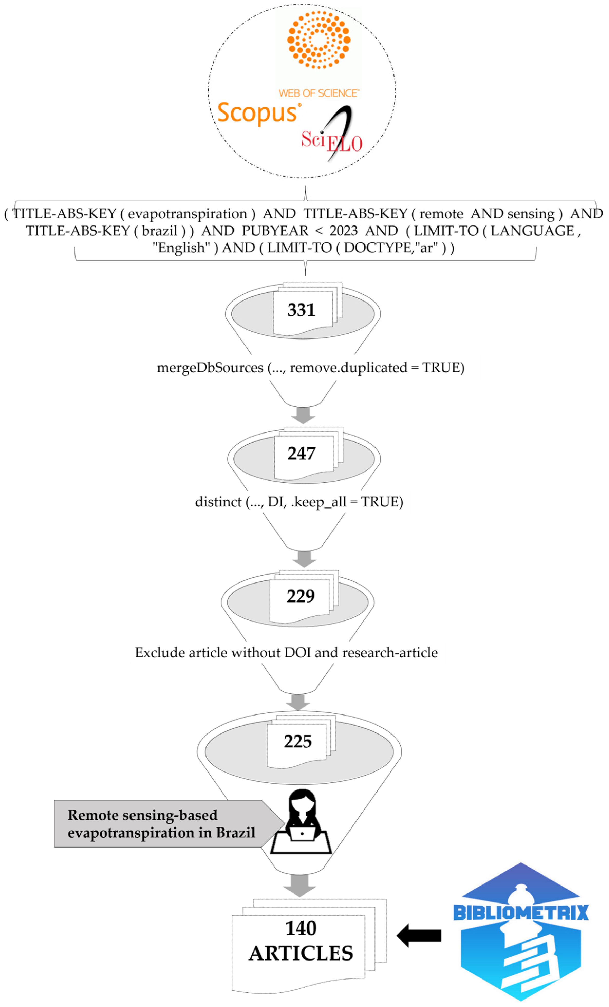
2. Material and Methods
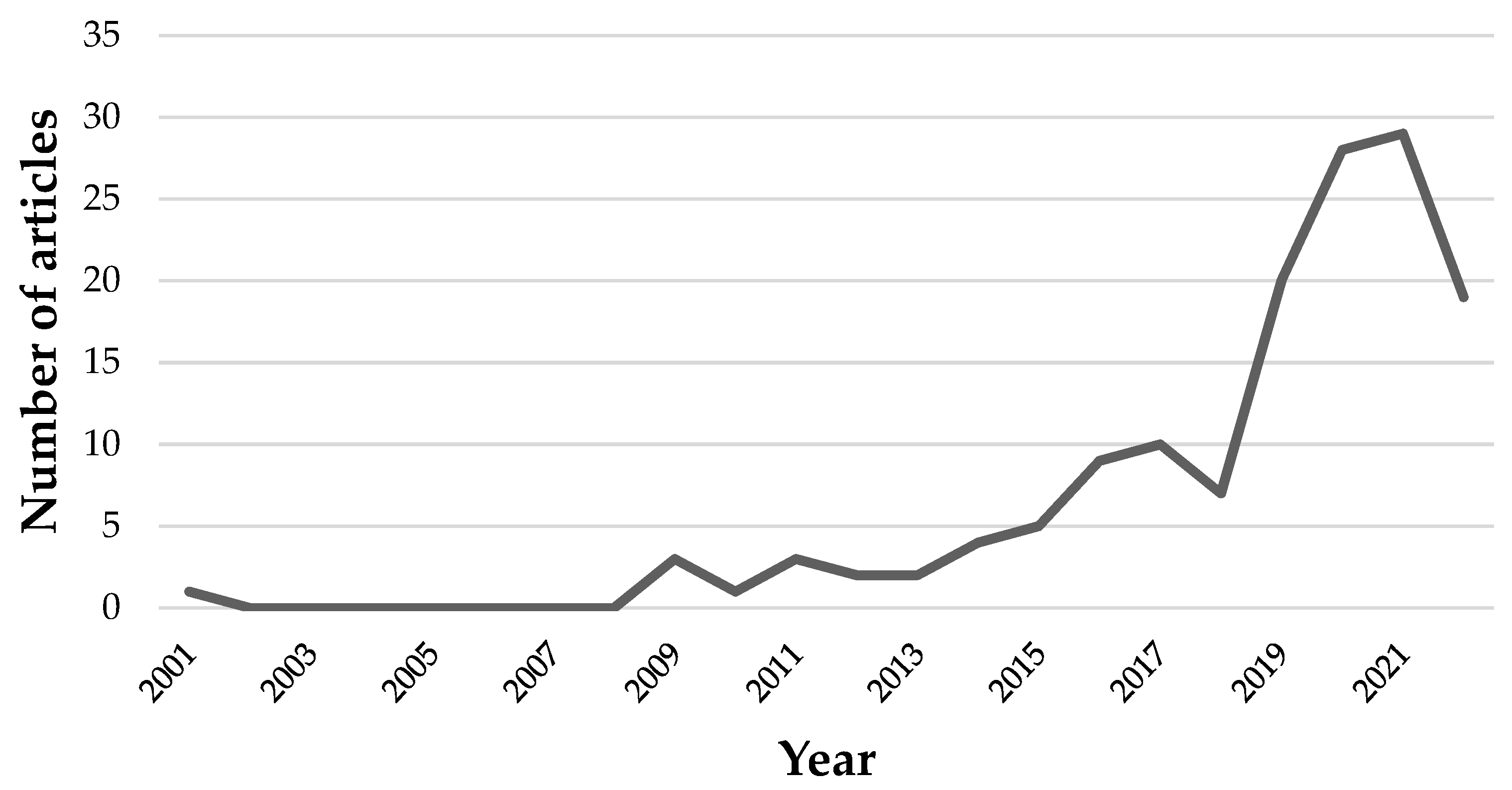
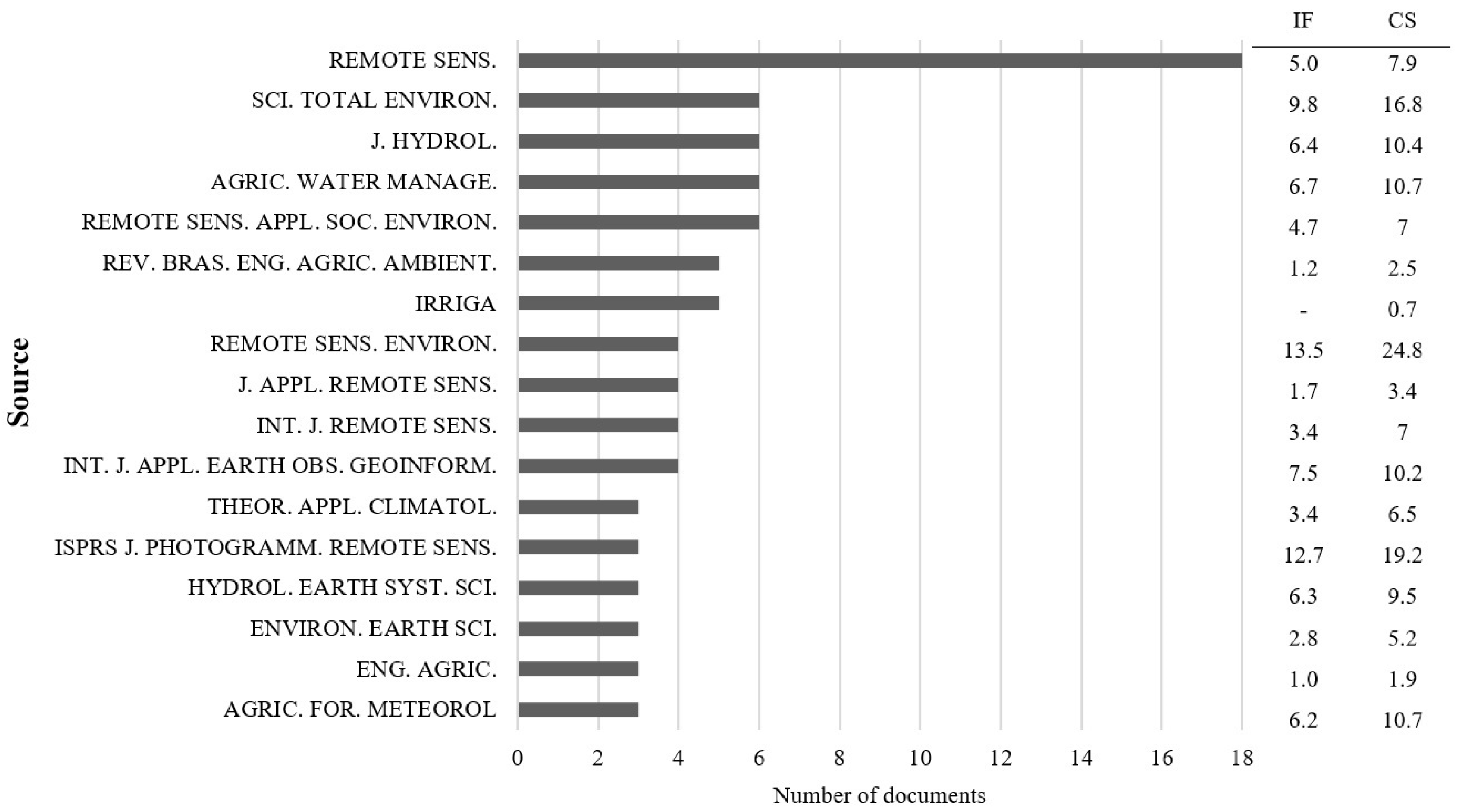
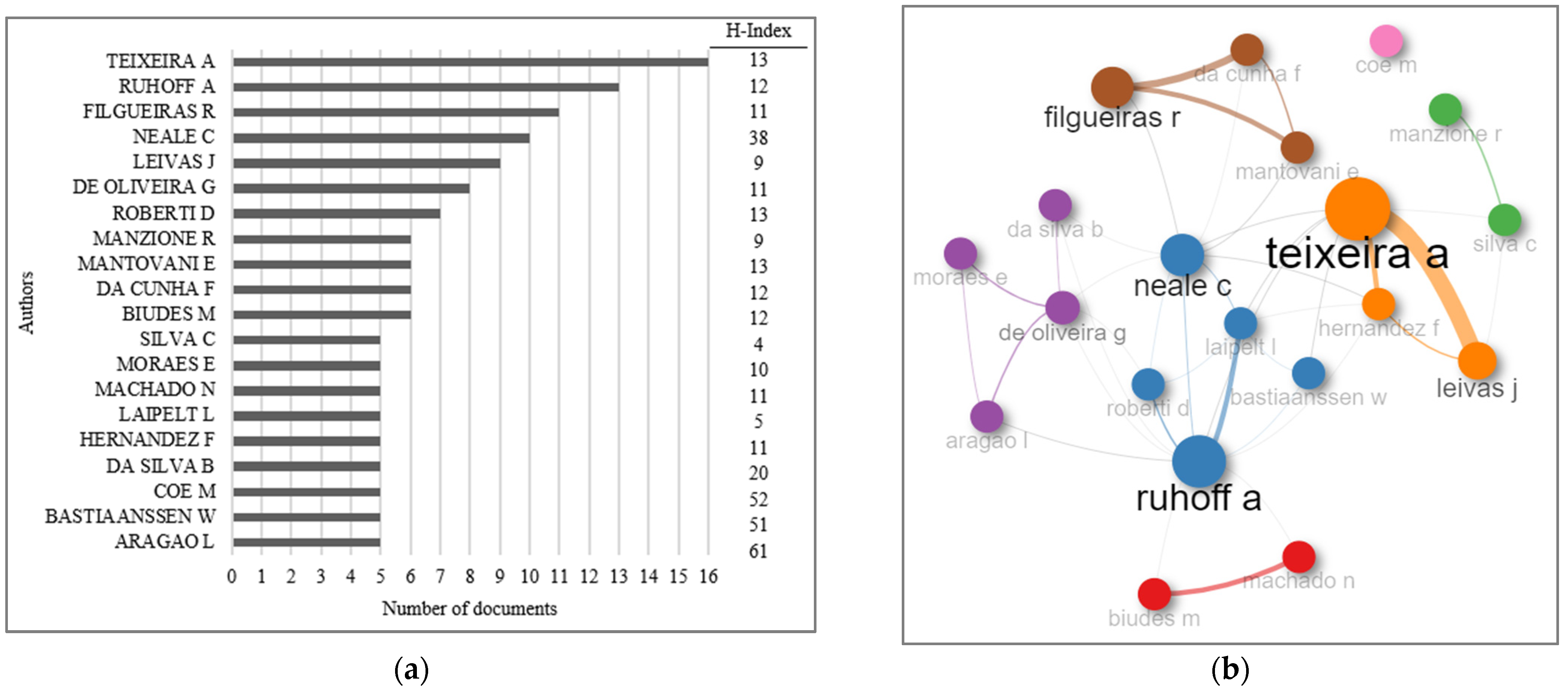
The article selection process targeted studies published in high-impact journals indexed in Scopus, Web of Science, and Scielo databases. Using “Evapotranspiration”, “Remote sensing”, and “Brazil” as keywords in all search fields, we retrieved articles published in English up to 2022, with no initial year limit. This yielded 112, 208, and 11 articles from Scopus, Web of Science, and Scielo, respectively (Figure 1).
We imported records from Scopus and Web of Science into RStudio using the Bibliometrix package, which handles both databases seamlessly, details about the script can be checked in Appendix A. Due to specific technical limitations, Scielo articles were identified through the Web of Science and imported separately. Finally, all records were merged into a single data frame using the mergeDbSources function from Bibliometrix, with duplicate entries (84 of 331 articles found across multiple databases) removed using the remove.duplicated logic. This resulted in a final dataset of 247 unique articles (Figure 1).
Following further deduplication, 18 articles were excluded: 2 lacked DOIs, and 2 were reviews. This left 225 articles (Figure 1). We then hand-reviewed each article to confirm its focus on Brazil and its use of remote sensing products or models for ET estimation. This final review yielded 140 articles suitable for scientometric analysis (Figure 1 and Appendix B). To ensure consistent author and affiliation data, we manually reviewed the bibliographic information in the registration table of these 140 articles. This standardization step improved the accuracy of subsequent analyses, which were performed using the biblioshiny tool from the Bibliometrix library for RStudio. The evaluated articles were published between 2001 and 2022. To understand their impact over time, we calculated the normalized average number of citations per year (NACPY) for each article. This metric is calculated by dividing the total number of citations by the time since publication [43].

3. Results

After applying various filters, a final corpus of 140 articles addressing our research theme was obtained. These articles were published between 2001 and 2022, with a clear trend of increasing research activity over time. As visualized in Figure 2, a remarkable over 60% of the articles were published in the last four years alone (2019–2022). This surge in publications suggests growing interest and momentum in the field. Notably, 2021 is the most prolific year, contributing 20% of the total corpus.
A total of 66 scientific journals published articles on the topic covered in this study (Figure 3). Among these, 49 journals contributed 1 or 2 articles, while 17 journals published three or more. Notably, journals with three or more articles accounted for 59.7% of the total studied here. It is worth highlighting two noteworthy journals. Irriga (ISSN—1808-8546) only lacks an impact factor. Conversely, Remote Sensing Applications: Society and Environment (ISSN 2352-9385), though established in 2015, boasts a high CiteScore and impact factor compared to older journals. Published by Elsevier and indexed in both Scopus and Web of Science, this journal focuses on remote sensing studies with an emphasis on environmental and social issues, including regionally/locally focused research with global significance.
The following journals have remote sensing as their main scope of publication: Remote Sensing of Environment (1970), ISPRS Journal of Photogrammetry and Remote Sensing (1963), International Journal of Applied Earth Observation and Geoinformation (1999). All three are published by Elsevier and indexed in Scopus and Web of Science. Additionally, we consider the Journal of Applied Remote Sensing (2007), published by SPIE, and Remote Sensing (2009), published by MDPI.
Beyond remote sensing, the investigated publications draw from interdisciplinary fields such as meteorology and climatology. Examples include Agricultural and Forest Meteorology (1963) and Theoretical and Applied Climatology (1949), both Scopus- and Web of Science-indexed journals published by Elsevier and Springer, respectively.
Hydrology is another key area, represented by the Journal of Hydrology (1963) and Hydrology and Earth System Sciences (1997), covering themes such as the hydrological cycle, modeling, river basins, and water resource management. Both are indexed in Scopus and Web of Science and published by Elsevier and EGU, respectively. The journal Agricultural Water Management (1978), published by Elsevier and indexed in Scopus and Web of Science, focuses specifically on agricultural water management, including drainage, modeling, and river basin management.
In addition to the journal Irriga, Brazil contributes the following relevant agricultural science journals: Engenharia Agrícola (1972), published by the Brazilian Association of Agricultural Engineering (SBEA) and indexed in Scielo, Scopus, and Web of Science; and Revista Brasileira de Engenharia Agrícola e Ambiental (1997), published by Editora da Universidade Federal de Campina Grande (EDUFCG) and indexed in the same databases.
Finally, two multidisciplinary journals broaden the scope: Environmental Earth Sciences (2009), published by Springer and indexed in Web of Science, covers interactions between natural resources and human activities, including soil science, hydrology, and pollution; and Science of the Total Environment (1972), published by Elsevier and indexed in Scopus and Web of Science, explores the multifaceted relationships between humans and the environment.
Among the 140 analyzed articles, 26 stand out with a normalized average number of citations per year (CN) exceeding 10 (Table 1 and Table 2). Notably, 17 of these high-impact articles were published within the past five years. This suggests a recent surge in interest and impactful research within this field. The oldest and newest articles with a CN above 10 are from 2009 and 2022, respectively, boasting impressive proportional CN values of 12.5 and 12.0. On the other hand, 27 articles show a CN below 1.0, highlighting the disparity in citation frequency. Among these, 15 are recent publications (2020–2022) with no citations yet. This could be due to their early publication date or niche audience.
The most-cited article, published in 2016 and titled “Land-use change affects water recycling in Brazil’s last agricultural frontier”, holds the crown with the highest CN. This study used the MODIS sensor’s MOD16 product to estimate evapotranspiration in the MATOPIBA region. Interestingly, the focus on large geographical areas seems to be a recurring theme among highly cited works. The second most cited article delves into the Amazon biome, and the third encompasses eight Brazilian states. This trend suggests the importance of regional-scale research in driving impactful contributions to this field.
Among the 26 high-impact articles (CN > 10), 19 tackle evapotranspiration at a global or regional scale, while only seven address it at a more localized level (e.g., municipal, river basin, or experimental) (Table 1). This trend suggests that research with a broader geographical scope garners more citations. Articles with a smaller spatial scale are more cited by institutions located close to the study area. For example, articles such as ID14, focusing on the Seridó Ecological Station in Rio Grande do Norte, tend to be cited primarily by institutions within the Northeast region. This demonstrates their local significance while highlighting the importance of geographically targeted research. It is also important to note that self-citation articles are cited more. For example, articles ID19 and ID21 are most cited by the first author.
The citation patterns of these 26 articles follow a characteristic parabola-shaped curve (Table 2). Initially, they experience a slow climb as their findings become known and assimilated within the research community, as is the case with ID6, ID8, ID12, ID15, ID17, ID19, and ID23. Then, they peak in citation frequency as their impact matures and their value is firmly established. Finally, after reaching this peak, citations gradually decline as newer research emerges and builds upon their contributions, eventually leading to obsolescence [42]. This pattern underscores scientific knowledge’s dynamic nature and research frontiers’ continuous evolution.
Table 2. Annual citation frequency for articles analyzing evapotranspiration in Brazil using remote sensing, with a normalized average citation rate exceeding 10 per year. Articles are indexed in Scopus, Web of Science, and Scielo. IDs refer to Table 1.
Year of PublicationArticleCitations/Year
20092010201120122013201420152016201720182019202020212022
2016ID 1 5193133604238
2020ID 2 102831
2016ID 3 3221627384446
2021ID 4 329
2018ID 5 318273135
2021ID 6 021
2019ID 7 382023
2018ID 8 09201527
2016ID 9 1071819171223
2011ID 10 6141718302120191151215
2021ID 11 412
2014ID 12 0610151416152426
2021ID 13 312
2020ID 14 9119
2017ID 15 0111091623
2019ID 16 312116
2021ID 17 013
2009ID 1854822141414121271514813
2013ID 19 028119171691819
2021ID 20 39
2022ID 21 12
2019ID 22 28816
2019ID 23 061115
2017ID 24 168141113
2020ID 25 6510
2019ID 26 5818
Hydrology 11 00039 i001
Although Baker J. boasts two high-impact articles (CN > 10) in our analysis (ID 11 and 23), he is not among the most prolific authors (Table 1 and Figure 4a). Interestingly, only three authors with five or more articles have a CN above 10 (Laipeld L., Teixeira A., and Ruhoff A.). Notably, Ruhoff A. authored one high-impact article and co-authored three others (IDs 4, 8, and 16) (Table 1).
Figure 4 reveals a stark collaboration trend. Out of 633 identified authors and co-authors, 485 appear in just one article. In contrast, only 20 individuals contributed to at least five articles. Single-authored papers are scarce, with only two identified in our selection. One of them, authored by Getirana A., even boasts a CN exceeding 10 (Table 1).
Interestingly, none of the most prolific authors (with at least five articles) were first authors. Figure 4a illustrates that researchers such as Aragão L., Hernandez F., Da Cunha F., Moraes E., Mantovani E., Roberti D., Leivas J., Neale C., and Coe M excel through impactful co-authorship. Despite contributing to only five articles and never as the first author, Aragão L. holds the highest H index (61) among this group (Figure 4a). While this might seem contradictory, it can be explained by Aragão L.’s affiliation with the National Institute for Space Research (INPE) and its expertise in remote sensing. However, it is important to note that Aragão L.’s research primarily focuses on the carbon cycle and land use changes, not directly on evapotranspiration, which explains the disconnect between publication quantity and H index in this specific context.
Coe M. also stands out with a high H index (52), despite co-authoring only five articles (Figure 4a). Interestingly, he co-authored the article with the highest CN (ID 1—Table 1). While an impressive feat, it is worth noting that Coe M. is a researcher at the Woodwell Climate Research Center, which investigates global climate changes but does not primarily focus on Brazil, one of the filters used in this study. This explains the high H index but limited authorship within the chosen scope. Bastiaanssen W., with only five articles to his name, comes in second with a remarkable H index (Figure 4a). This seemingly low output belies his significant contribution; he pioneered the SEBAL methodology for evapotranspiration estimation via remote sensing. However, it is important to remember that the initial analysis in these articles was not focused on Brazil [17].
Teixeira A. is another key author, contributing to 16 articles (Figure 4a). Two stand out, with citation counts (CN) exceeding 10. The first, published in 2009, lists Teixeira A. as the lead author. The other, published more recently in 2022, already boasts a CN of 12 (IDs 18 and 21, respectively—Table 1). Notably, Teixeira A. is the first author in 10 of the 16 articles he participates in (solely authoring one). His network of collaborators is also noteworthy, forming a dense cluster in Figure 4b. Interestingly, Teixeira A. is a researcher at the Brazilian Agricultural Research Corporation’s semi-arid unit, which explains why eight of his articles focus on the Northeast Brazilian region as the study area.
Ruhoff A. emerges as a prolific author, contributing 13 publications out of 140 (Figure 4a). He takes lead authorship on three of these. Notably, Ruhoff A. collaborates extensively, connecting with 11 authors with five or more published articles and forming links with three distinct author clusters (Figure 4b). Regionality, he plays a strong role in his collaborations. One group, containing Ruhoff A. himself, shares ties to Rio Grande do Sul. Ruhoff A. and Laipelt L. hail from the Federal University of Rio Grande do Sul (UFRGS), while Roberti D. comes from the Federal University of Santa Maria (UFSM). Beyond regional connections, Ruhoff A. also collaborates with Bastiaanssen W. from the Netherlands and Neale C. from the United States.
Similar regional patterns emerge in other clusters. Manzione R.’s collaborators are affiliated with universities in São Paulo (UNESP and UNICAMP), while Biudes M. and Machado N.’s network centers around institutions in Mato Grosso (UFMT and IFMT) (Figure 4b). The cluster of Filgueiras R., Da Cunha F., and Mantovani E. further strengthens this trend, with all members belonging to the same institution (UFV) (Figure 4b).
International collaboration adds a crucial dimension. Nearly 24% of authors or co-authors come from outside Brazil, highlighting the increasingly interconnected nature of scientific research. The Sankey diagram (Figure 5) visualizes these connections, using rectangles to represent author categories (scaled by frequency) and lines to show collaboration flows.
Ruhoff A. and Filgueiras R. stand out for their frequent collaborations. Their flows primarily connect them to Brazilian institutions and their home universities (UFRGS and UFV). Both also show collaboration lines with the United States. However, Ruhoff A. extends his network further, linking with researchers from France and the United Kingdom (Figure 5).
As expected, Brazil dominates the landscape, with author flows occurring for 19 of the top 20 contributors. The United States follows closely behind, appearing in flows for 16 of the top 20. Similarly, among the 20 main institutions associated with the 140 publications, 17 are Brazilian, with 2 American institutions (University of Nebraska and University of Maryland) and 1 Dutch institution (IHE Delft Institute for Water Education) rounding out the list.
The UFV and UFRGS emerge as the institutions with the highest association frequencies in the analyzed articles (Figure 6a). Their flows primarily involve Brazilian authors, particularly those affiliated with their respective institutions. Across the 140 articles, authors and co-authors were affiliated with a total of 245 institutions. Among the top 15 institutions, the landscape reflects a strong Brazilian presence, with 11 universities being federally or state-funded. Interestingly, North American institutions hold two spots (the University of Nebraska and the University of Maryland), while the National Institute for Space Research (INPE) represents the sole research-focused institution (Figure 6a).
Further analysis reveals a clustering pattern among the top 15 institutions, dividing them into two distinct groups (Figure 6b). The first cluster consists of institutions from the South and Southeast regions, while the second encompasses those from the Midwest and Northeast. Institutions from the Southeast region contribute significantly to the research, accounting for 47.2% of the analyzed articles. Within this cluster, São Paulo dominates, with institutions such as USP, UNESP, and INPE playing key roles. Notably, UFV from Minas Gerais is the only exception. South-region institutions are responsible for 17.4% of the articles, with UFRGS and UFSM standing out as the lead forces. Institutions from the Midwest region contribute 13.2% of the articles, primarily driven by UFMT and UNEMAT. The Northeast region boasts many prominent institutions, contributing 19.4% of the articles. UFCG, UFRPE, UFPE, UFPB, and UFRN emerge as the key players in this cluster. While representing a smaller portion, North American institutions contribute 13.2% of the articles. Notably, the University of Nebraska and the University of Maryland lead the collaboration within this category. These revised and annotated sections with accompanying visuals shed light on the institutional landscape revealed in our analysis. The emphasis on regional clusters and leading institutions within each region adds a clearer picture of the geographical distribution of collaborations.
UFRGS and UFSM lead the pack in co-authored publications, each contributing seven collaborative articles. Their strong regional influence within the first cluster is evident. USP and the University of Nebraska follow closely, with six co-authored articles each, representing the second cluster’s collaborative strength. Interestingly, a bridge between the two clusters emerges through co-authorship. USP and UFMT have partnered on three published articles, demonstrating valuable cross-regional collaboration. While UNESP ranks high in overall article count (Figure 6a), its collaborative profile differs significantly. Unlike USP and UFRGS, UNESP displays limited collaboration with other institutions. Notably, it published only two co-authored articles with USP and the University of Nebraska each and a single article with UFV and UFRGS combined (Figure 6b). This suggests a more independent research approach for UNESP within the first cluster.

4. Discussion

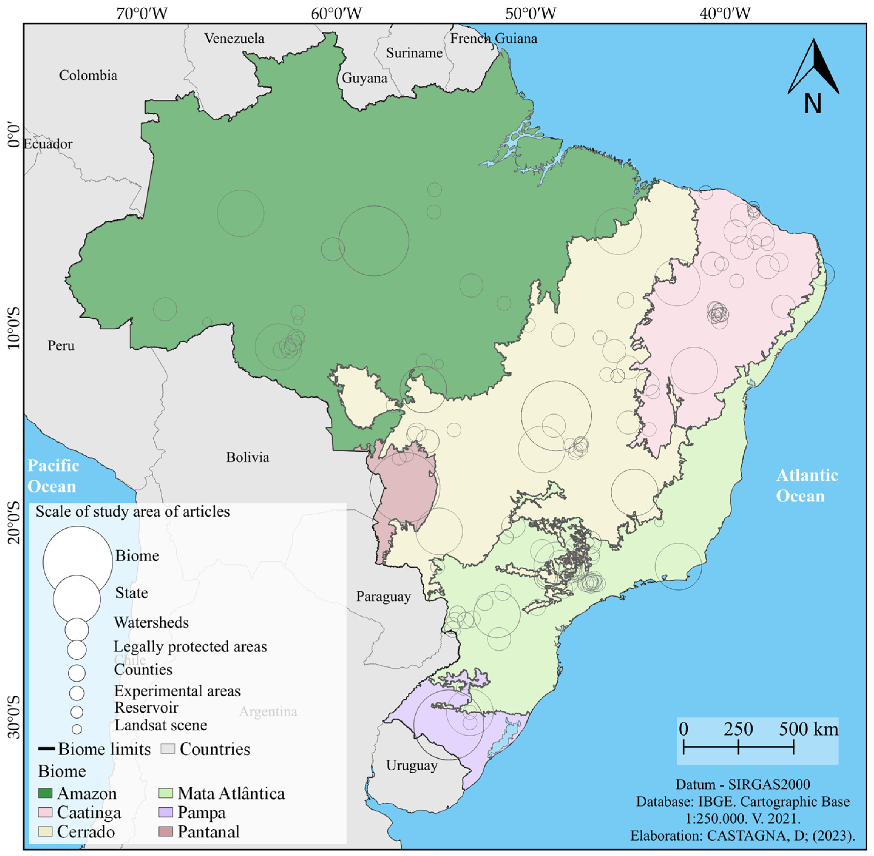
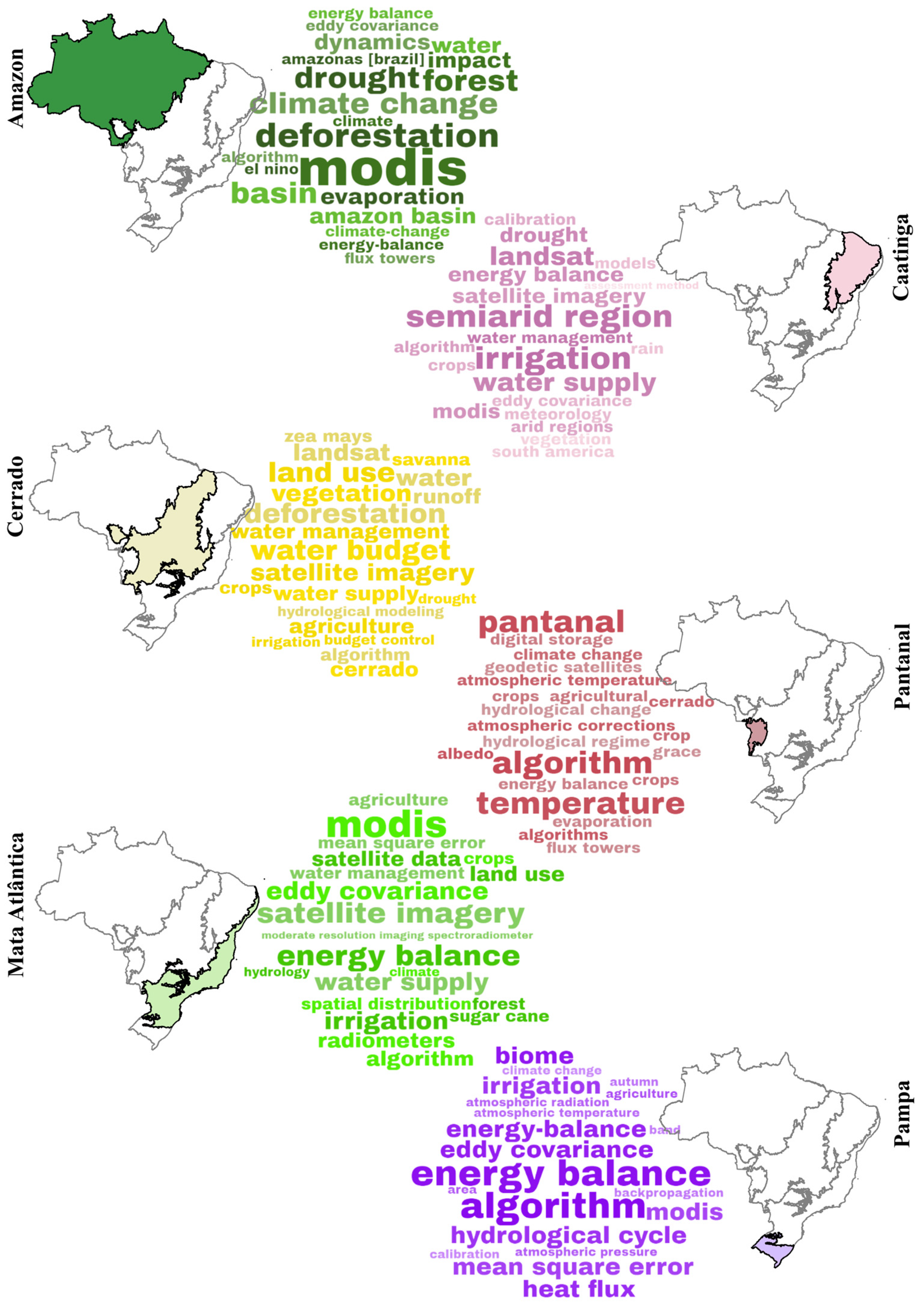
4.1. Scientific Production on Evapotranspiration by Remote Sensing in Brazil by Brazilian Regions and Biomes

Those located within the state of São Paulo stand out among institutions with the highest publication count. Research conducted within its territorial limits yielded the largest number of articles evaluated (21), highlighting its central role in this field (Figure 7). However, the geographic distribution of research extends beyond São Paulo. Interestingly, in all analyzed articles, several states, including Alagoas, Espírito Santo, Santa Catarina, Roraima, and Amapá, are not represented as study areas (Figure 7). This points to potential research gaps and opportunities for future investigations in these regions. From a regional perspective, the Northeast region is the most active, contributing 36 articles to the analyzed corpus. Specifically, the municipalities of Juazeiro (BA) and Petrolina (PE) are the focus of research in 10 of the evaluated articles, showcasing active investigation efforts in this area (Figure 7).
The spatial scales at which remote sensing evapotranspiration estimation methodologies are applied in Brazil vary considerably. Studies range from global-level analyses to highly localized assessments focused on experimental areas or specific scenes captured by Landsat satellites. Examples of global-scale articles include works by Javadian et al. [21] and Zhou et al. [22] (both with citation counts below 10, Table 1). Interestingly, these articles lack Brazilian authors or affiliations, showcasing international collaborations and knowledge exchange. Their authorship teams boast researchers from China, the United States, Canada, and Australia. Only one article focusing on tropical forests made it into the research pool. This study, by Saatchi et al. [13], boasts a high citation count (15) and a diverse team of 58 authors from 50 affiliations. Notably, only one Brazilian author, Carlos Nobre, appears in this consortium (Table 1).
Focusing on remote sensing studies for large-scale ET evaluation, we reviewed seven articles for South America [24,37,39,44,45,46,47], four for Brazil [25,48,49,50], and seven at the regional level. For regional studies, three assessed the Northeast region [10,51,52], one covered both the Southeast and Northeast regions [53], another focused on the Bauru mesoregion in São Paulo [54], and one each dealt with transition zones between the Cerrado and Amazon (Cerrado/Amazônia and Urucuia Aquifer) [55,56,57].
Brazilian biome-specific studies (covering the entire national extent) yielded 13 articles. These were further categorized as follows: four on the Cerrado [58,59,60,61], four on the Pampa [62,63,64,65], three on the Amazon [7,27,66], and two on the Pantanal [67,68]. Additionally, one study analyzed ET across several states (Maranhão, Piauí, Bahia, Mato Grosso, Mato Grosso do Sul, Goiás, Paraná, and Rio Grande do Sul) [23].
Moving to smaller scales, a larger number of articles emerged. Focusing on the edges of the Cerrado biome between 2011 and 2022, we identified 40 articles. These included eight state-level studies (three in Minas Gerais and five in Mato Grosso), two at the municipal level, eleven within river basins, four in legally protected areas (two each for the Santa Bárbara and Angatuba Ecological Stations and one for Chapada dos Guimarães National Park), and fifteen stemming from experimental areas (Figure 8).
The studies conducted in the Atlantic Forest biome yielded a total of 25 articles published between 2011 and 2022. Among these, three articles focused on a state scale (Rio de Janeiro, São Paulo, and Paraná), five on a municipal scale, eight on river basins, five in experimental areas, and four on Landsat scenes (Figure 8). Additionally, an article that explores the transitions between the Atlantic Forest and Cerrado biomes in the Bauru mesoregion of the state of São Paulo was identified.
In the Caatinga biome, 24 articles were identified. These included two articles at the municipal scale, one related to protected areas (specifically, the Estação Ecológica do Seridó in Serra Negra do Norte), five focused on river basins, fourteen in experimental areas, and two articles related to hydroelectric reservoirs. The articles about this biome were published between 2001 and 2022. Notably, the oldest among the 140 evaluated articles (dating back to 2001) was authored by Bastiaanssen et al. [69], who studied a small experimental area in the state of Pernambuco (Figure 8).
Within the Amazon biome, 15 articles were discovered. These included two articles at the state scale (Amazonas and Rondônia), two at the municipal scale, five related to river basins, five in experimental areas, and one focusing on a Landsat scene. The articles published in the Amazon region are relatively recent, with the oldest dating back to 2016 and the newest published in 2022 (Figure 8). In contrast, only two articles per biome centered around experimental areas were found for the Pantanal and Pampa biomes (Figure 8). Specifically, the articles related to the Pantanal biome were published in 2015 and 2021, while those for the Pampa biome were published in 2014 and 2022.

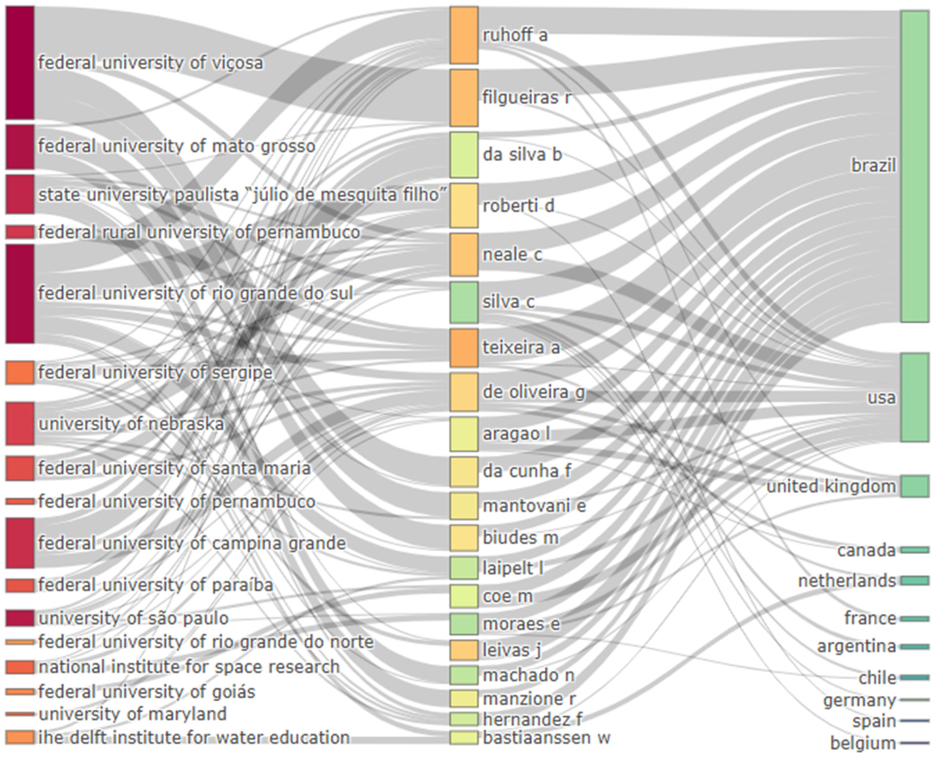
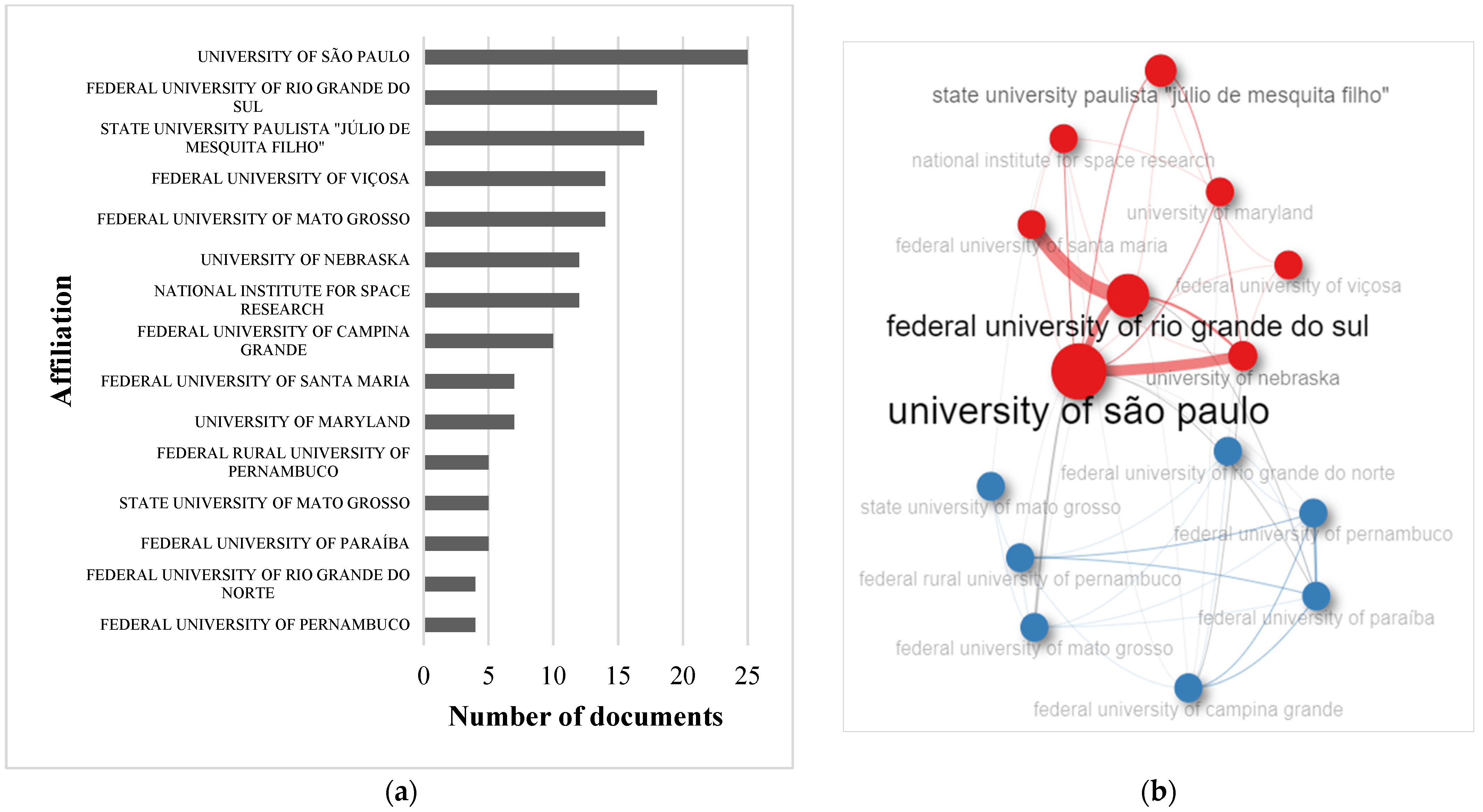
4.2. Scientific Production on Evapotranspiration by Remote Sensing in Brazil in Scientific Institutions and Strictu Sensu Postgraduate Programs

The analysis of author affiliations reveals a strong spatial bias towards institutions located within or near the biomes where the research was conducted. This trend is particularly evident in the Caatinga biome, where 10 of the 11 institutions with two or more articles are situated in the Northeast region, the only region in Brazil encompassing the Caatinga (Table 3).
Similar patterns of localized institutional prominence can be observed in the Cerrado, Atlantic Forest, Pampa, and Pantanal biomes. Notably, the Amazon biome stands out as an exception. Only two of the eleven institutions with two or more articles are located within the Amazon region: one from the Northeast (INPE) and one from the Southeast (UFRRJ). Six additional institutions involved in Amazon research are international (Table 3).
The Amazon biome’s rich biodiversity and ecological significance attract significant international research interest, as evidenced by the many foreign institutions contributing to ET studies in the region [70,71]. However, this international influence comes alongside concerns about local scientific capacity. One potential factor limiting local research output is the scarcity of postgraduate programs (PPGs) in multidisciplinary areas relevant to ET studies, such as environmental sciences, geosciences, and exact and earth sciences. Focusing solely on environmental sciences PPGs within the Amazon biome, we find only 18 programs offered across 11 institutions in seven states. This contrasts starkly with the state of São Paulo, which boasts 20 programs alone [72].
Beyond quantity, the quality and financial resources of PPGs also play a role in research output. In Brazil, PPGs undergo a four-year assessment determining their concept rating (ranging from 3 to 7) based on program quality, human resource training, scientific production, and social engagement. Higher concept ratings translate to increased funding from public research agencies, enabling programs to attract and retain talent and support research projects. The limited number and resources of PPGs in the Amazon raise important questions about knowledge production and international collaboration in the region. While international engagement enriches research, fostering robust local research capacity is crucial for tackling the unique challenges and opportunities of the Amazon biome. Investing in PPGs, promoting multidisciplinary approaches, and ensuring equitable access to research resources are essential steps towards empowering local researchers and generating valuable knowledge that benefits both the Amazon and the world.
The environmental sciences postgraduate programs (PPGs) located in the Amazon biome can be considered relatively new, as they have been in operation for an average of 11 years (with the oldest program established in 2000 and the newest in 2019). Two recently created programs (in 2018 and 2019) have not yet undergone the four-year evaluation (the last evaluation cycle being 2017–2020) and currently operate with authorization only. Among the remaining 16 PPGs in the Amazon, only one has achieved a concept rating of “5”, while the majority fall within the “3” or “4” range [71].
In Brazil, alongside the quadrennial evaluation, there exists a periodic assessment system known as Qualis (Qualis-Periódicos or Qualis/CAPES), overseen by the Coordination for the Improvement of Higher Education Personnel (CAPES). This system aims to list and categorize periodicals used for disseminating intellectual production in postgraduate programs of the “Strictu Sensu” type. It considers factors such as circulation scope (local, national, or international) and quality (across nine levels) based on the area of evaluation/knowledge. Qualis seeks to minimize subjectivity in assessing the quality of scientific journals by considering their indexing in national and international databases as well as international bibliometric indicators (such as JCR and CiteScore). Generally, scientific journals with international reach receive higher classifications in Qualis due to their elevated JCR and CiteScore values, except those considered “predatory” by the community.
The challenging cycle between the low production of high-impact articles and the quality of PPGs arises from difficulties in accessing financial resources from research funding agencies for scholarships (master’s, doctorate, and post-doctorate). This cycle exacerbates disparities between well established and developing programs across different Brazilian regions. To achieve excellence, it is crucial to allocate resources that uplift lower rated PPGs [73], rather than encouraging the closure of programs with Qualis ratings of “3” or “4” or directing resources solely to already consolidated programs [74,75].

4.3. Applications of Remote Sensing Evapotranspiration in Brazil

Brazilian biomes exhibit unique characteristics and specific needs. These distinct features and researchers’ perspectives and regional challenges shape the research conducted within each biome. This context is evident in articles focusing on evapotranspiration through remote sensing. The keywords prevalent in Brazilian articles related to remote sensing and evapotranspiration reflect the specific context of the research. The most frequently used terms include references to remote sensing technologies, such as MODIS, Landsat, and satellite imaging. Additionally, methodological terms such as “algorithm”, “calibration”, and “models” are commonly encountered. Finally, keywords associated with study regions—such as Pantanal, Cerrado, Amazon, semi-arid areas, and South America—also feature prominently (Figure 9).
However, it is possible to discern biome-specific nuances within the published articles. For instance, in the Amazon biome, the top 20 keywords include “river basins”, “climate”, “climate change”, “El Niño”, and “deforestation” (Figure 9). Deforestation in the Amazon and its local and global implications are focal points in numerous scientific studies. When examining evapotranspiration, deforested areas and post-deforestation land use (whether for livestock or agriculture) exhibit distinct evapotranspiration patterns compared to forested regions [7,36,76,77,78].
In the Cerrado biome, the keywords of published articles can be divided into the following two main distinct groups: water resources (including terms such as water, water management, runoff, water supply, and hydrological models) and land use changes (such as deforestation, vegetation, agriculture, land use change, plantations, and Zea Mays, which refers to corn) (Figure 9). These keywords are closely related to the intrinsic characteristics of the Cerrado. Notably, the Cerrado is home to eight significant Brazilian river basins, serving as the source for rivers such as São Francisco, Paraíba, and Tocantins. Additionally, it is considered a recharge zone for the Guarani aquifer [60,79,80]. Given its intense agricultural exploitation, approximately 45.3% of the Cerrado’s area is occupied by agriculture, livestock, forestry, and various mosaic land uses [81]. The first group of keywords (related to water resources) is not entirely disconnected from the second group (about land use). Changes in land use, such as deforestation for agricultural purposes, significantly impact the components of the hydrological cycle [58,82].
Moving to the Caatinga biome, the keywords in the articles evaluated here strongly reflect the semi-arid characteristics of this region. Terms such as irrigation, management, and water supply (Figure 9) underscore the importance of water in the Caatinga biome. Given its scarcity, water plays a critical role in agricultural production. Accurate estimation of evapotranspiration is essential for understanding plant water needs. Moreover, effective water management is crucial to prevent waste, especially during dry periods or in arid regions [83,84].
The most prominent keywords in the Atlantic Forest biome revolve around energy balance and evapotranspiration estimation by remote sensing. These terms are closely associated with specific methodologies, including two-source energy balance (TSEB), surface energy balance algorithm for land (SEBAL), and ground-truthed surface energy balance (GT-SEB) (Figure 9). Notably, the term “sugar cane” also ranks among the top 20 keywords for the Atlantic Forest. This is because articles using this term are often situated in the state of São Paulo, which is the largest national sugarcane producer (Figure 9).
However, due to the limited number of evaluated articles for the Pampa and Pantanal biomes, it was impossible to discern clear trends or logical relationships between the articles and their respective study areas (Figure 9).

4.4. Main Remote Sensing Methodologies for Estimating Evapotranspiration in Brazil and the Amazonian Biome

The 140 evaluated articles fall into the following three main categories based on their goal for acquiring evapotranspiration data: (i) articles that use the evapotranspiration estimated by remote sensing for study objectives; (ii) articles that propose new remote sensing-based evapotranspiration models; and (iii) articles that validate and optimize remote sensing-based evapotranspiration models for a specific location.
Articles in the first category leverage evapotranspiration data from remote sensing to achieve their research goals. For example, Coelho et al. [84] used the SEBAL model’s evapotranspiration estimates to assess groundwater recharge in a semi-arid river basin, while Silva et al. [84] employed the same approach to map soil salinity during the dry season in a Bahian experimental area. Other studies explored the impact of human activities on climate, microclimate, and evapotranspiration. Loarie et al. [59] analyzed the MOD16 evapotranspiration product to evaluate the climatic consequences of sugarcane expansion in the Cerrado, while Pinheiro et al. [85] utilized the SEBAL model on a smaller scale to investigate the effect of urbanization in a Mato Grosso municipality.
The second category highlights research that develops innovative models for estimating evapotranspiration using remote sensing data. Notable examples include Paca et al.’s [31] ET-Amazon product and Teixeira’s [86] PM1 and PM2 proposals. ET-Amazon [31] combines six existing models and products (GLEAM, SEBS, ALEXI, CMRSET, MOD16, and SSEBop) to create a basin-wide evapotranspiration estimate tailored to the Amazon’s complex vegetation. Teixeira [86], on the other hand, proposes two models (PM1 and PM2) based on the Penman–Monteith equation, integrating satellite and field data with the NDVI vegetation index. Notably, one of these proposals, SAFER (Simple Algorithm For Evapotranspiration Retrieving), enabled crop coefficient (kc) estimation for optimizing water use in agriculture and was adopted in 21 of the 140 evaluated articles, primarily within the agricultural sector (17 articles), particularly in irrigated experimental areas (12 articles).
It is important to highlight that the NDVI, present in the SAFER model, is not recommended for regions with sparse vegetation and exposed soil, such as semi-arid regions [87]. However, 12 published articles that used SAFER in areas with these characteristics were observed. These articles are justified because they were developed in homogeneous irrigated areas. The other articles that use the SAFER model do not deal with irrigated areas and are outside the Brazilian semi-arid region. In this context, it would be interesting for future work to evaluate the possibility of using other vegetation indices together with the SAFER model, such as the SAVI (Soil_Adjusted Vegetation Index) [88], recommended for semi-arid regions, the NDWI (Normalized Difference Water Index) [89], sensitive to liquid water in vegetation, or the EVI (Enhanced Vegetation Index) [9].
Articles in the third category focus on finding the best model or product for estimating evapotranspiration at a specific location, often validating their results with in situ data from agrometeorological stations or flux towers. For example, Lima et al. [90] compared the METRIC and STSEB models with lysimeter data in a sorghum area, revealing slight underestimations. Flux towers with the Eddy Covariance system are the most used in situ data source for model comparisons. Dos Santos et al. [91] compared SEBAL and MOD16 with flux tower data in the Seridó Ecological Station, finding that MOD16 performed better in the driest period. In the Amazon, Paca et al. [38] compared in situ data with SSEBop and GLEAM, finding underestimates but better overall agreement with SSEBop.
Several studies evaluated the accuracy of evapotranspiration estimates from remote sensing models and products across different scales. Moreira et al. [24] compared two widely used products, GLEAM and MOD16, using data from 16 flux towers in South America. While both showed underestimates compared to in situ measurements, GLEAM overall exhibited lower uncertainties. Baker et al. [92] took a different approach, estimating evapotranspiration as a “leftover” in the water balance equation (precipitation minus surface runoff and storage change). Analyzing data from the Amazon basin, they found MOD16 and P-LSH performed better than other methods, such as ERA5 and CMIP models, despite all underestimating actual evapotranspiration. Ruhoff et al. [39] also used the water balance residual method to estimate evapotranspiration in South America and Rodell et al. [93] applied the water balance residual method to estimate evapotranspiration in seven river basins in different locations around the world, including the Tocantins-Araguaia basin in Brazil. This highlights the potential challenges of using water balance methods, particularly due to uncertainties in surface runoff measurements.
The choice of model or product often depends on the study area’s size. With their coarser resolution, global products such as GLEAM or LandFlux-EVAL are ideal for large-scale analyses such as those involving continents [25,46,47] or entire biomes [7]. In contrast, studies focusing on smaller areas such as states [23] or river basins [93] often employ models such as SEBAL with higher spatial resolution. The MOD16 reanalysis product (250 m resolution) dominates large-scale studies such as Javadian et al.’s global analysis [21]. On the other hand, the SEBAL model, whose resolution adapts to the sensor used, is more common in smaller-scale studies such as Laipelt et al.’s work in Brazil [25]. Combining SEBAL with Landsat images (30m resolution) in large areas remains challenging due to computational limitations. However, Laipelt et al. [25] demonstrated the effectiveness of Google Earth Engine’s geeSEBAL tool in overcoming this hurdle.
Even within the Amazon biome (evaluated in 12 of 18 articles), MOD16 remains the most used method despite covering areas as large as 100,000 km² in nine cases. This preference for MOD16 might be due to its wider availability compared to higher resolution options. However, the complex land use and vegetation patterns in transition zones between the Amazon and Cerrado biomes call for studies with refined models and smaller spatial scales to achieve the accuracy needed for hydroagricultural and environmental applications.
As noted, some studies aim to identify the most suitable product for the case under study, comparing in situ data and satellite products or even between different products. Scientometrics work, like ours, plays a crucial role in offering insights into previously employed methods and products, including their characteristics and application areas. This avoids duplication of efforts and speeds up the scientific process by providing consolidated and reliable references.

5. Conclusions

Our scientometric analysis reveals a burgeoning interest in evapotranspiration estimation using remote sensing. This surge can be attributed to the following two key factors: (i) improved model accuracy, i.e., recent advancements in model development have yielded products and methodologies that demonstrate robust performance when compared to in situ data; and (ii) enhanced computing power, which allows for the handling of complex data involved in remote sensing analysis.
However, this growth is not evenly distributed. We observed a strong concentration of research activity in São Paulo, while the Amazon biome, despite its ecological significance, shows a surprising dearth of studies. This geographical imbalance can be explained by research infrastructure, e.g., São Paulo boasts the highest concentration of research centers and postgraduate programs, providing a fertile ground for scientific exploration, while the Amazon region is younger and has fewer research programs, facing relative disadvantages; and another explanation is the Amazon’s challenges, created by the complex vegetation patterns and frequent cloud cover in the Amazon which pose unique challenges for remote sensing analysis, requiring specialized models and processing techniques, which can be discouraging for researchers lacking robust infrastructure and technical expertise.
These findings highlight the urgent need to promote and support research programs in the Amazon biome. By fostering infrastructure development and tailored training programs, we can empower researchers to tackle the region’s specific challenges and unlock the full potential of remote sensing for studying evapotranspiration.
Interestingly, even within the Amazon, the MOD16 reanalysis product reigns supreme. While ease of access and cloud correction are valuable assets, their coarse resolution may mask valuable insights hidden within smaller spatial scales. The Amazon’s unique cloud cover patterns can also pose processing challenges for MOD16.
Therefore, smaller-scale studies using alternative models and processing methods hold immense promise for uncovering new perspectives on evapotranspiration dynamics in the Amazon. Investing in regional research capacity and exploring innovative approaches can unlock a wealth of knowledge crucial for managing this vital ecosystem.
The scarcity of articles on the proposed topic, especially for the Amazon biome, made it difficult to identify clear patterns in RS use of evapotranspiration products. As a suggestion for future research, it is recommended to search for articles that address areas of study with characteristics similar to those of the region under analysis. This will expand the set of information available, allowing for a more comprehensive analysis of trends related to the topic.

Author Contributions

Conceptualization, D.C. and A.P.d.S.; methodology, D.C.; software, D.C. and R.S.D.P.; validation, D.C., L.S.B., C.C.M. and A.P.d.S.; formal analysis, D.C. and L.S.B.; data curation, D.C.; writing—original draft preparation, D.C., C.C.M., R.S.D.P. and L.S.B.; writing—review and editing, N.G.M., M.S.B. and A.P.d.S.; visualization, N.G.M. and M.S.B.; supervision, A.P.d.S.; project administration, A.P.d.S.; funding acquisition, M.S.B. All authors have read and agreed to the published version of the manuscript.

Funding

This study was financed by the Coordenação de Aperfeiçoamento de Pessoal de Nível Superior—Brazil (CAPES), and the Agência Nacional de Águas e Saneamento Básico (ANA), Finance Code—001 and Process 88887.144957/2017-00. The authors wish to thank the Conselho Nacional de Desenvolvimento Científico e Tecnológico (CNPq) for their support with scientific initiation grants and a productivity grant (code #308784/2019-7, code #311541/2021-6 and #311907/2021-0).

Data Availability Statement

Study data can be obtained upon request to the corresponding author or the first author, via e-mail. The data are unavailable on the website as the research project is still being developed.

Acknowledgments

We thank the Federal University of Mato Grosso, the PPGCAM and PPGFA. The authors also thank all the students and professors of the “Tecnologia em Recursos Hídricos no Centro-Oeste” research group (dgp.cnpq.br/dgp/espelhogrupo/2399343537529589, accessed on 17 October 2023).

Conflicts of Interest

The funders had no role in the study’s design, in the collection, analyses, or interpretation of data, in the writing of the manuscript, or in the decision to publish the results.

Appendix A

Script para software RStudio, utilizado para unir os registros das bases indexadoras e filtra-los.
 
if(!require(pacman)) install.packages(“pacman”)
library(pacman)
pacman::p_load(bibliometrix, readr, writexl, dplyr) #Packages used in the script
 
setwd (“D:/Cienciometria”) # Indicate the folder where the script will be saved
 
# Upload scopus file
Scopus <- convert2df(“D:/Cienciometria/scopus.csv”, dbsource = “scopus”, format = “csv”)
 
# Upload web of science file
Web <- convert2df(“D:/Cienciometria/Web_of_Science.txt”, dbsource =“wos”,format =“plaintext”)
 
# Upload Scielo file
Scielo <- convert2df(“D:/Cienciometria/Scielo.txt”, dbsource =“wos”,format =“plaintext”)
 
# Union of the two databases, removing duplicates
merge <- mergeDbSources(Scopus, Web, Scielo, remove.duplicated = TRUE)
 
#The top line remove also has the function of removing duplicates, however there are still articles with duplicate DOI left, and this line removes the rest of the duplicates according to the DOI
distinct <-distinct(merge, DI, .keep_all = TRUE)
 
# Filter by the type of record, in this case article
filter_1 <- filter(distinct, DT==“ARTICLE”)
 
#Filters the language, in this case English
filter_2 <- filter_1[grepl(“ENGLISH”, filter_1$LA),]
 
#Exported in xlsx to then import into biblioshiny
write.xlsx(filter_2,file=“D:/Cienciometria/Database.xlsx”)
 
#After exporting the data, it is important to check the equality in the correspondence of the authors’ surnames and affiliations to avoid interpretation errors. Once the database is corrected, you must load it into Biblioshiny.
biblioshiny()

Appendix B

Articles consulted (140) for scientometric analysis with the theme of evapotranspiration by remote sensing in Brazil.
AuthorsDOIYearSource
BASTIAANSSEN et al.10.1023/A:10179670211982001Irrigation and Drainage Systems
FOLHES et al.10.1016/j.agwat.2009.04.0212009Agricultural Water Management
TEIXEIRA et al.10.1016/j.agrformet.2008.09.0142009Agricultural and Forest Meteorology
TEIXEIRA et al.10.1016/j.agrformet.2008.09.0162009Agricultural and Forest Meteorology
TEIXEIRA 10.3390/rs02512872010Remote Sensing
DA COSTA et al.10.1590/S0100-676220110004000092011Revista Arvore
LOARIE et al.10.1038/nclimate10672011Nature Climate Change
RODELL et al.10.1002/hyp.83692011Hydrological Processes
LATHUILLIÈRE et al.10.1088/1748-9326/7/2/0240242012Environmental Research Letters
RUHOFF et al.10.3390/rs40307032012Remote Sensing
RUHOFF et al.10.1080/02626667.2013.8375782013Hydrological Sciences Journal
TEIXEIRA et al.10.3390/rs51157832013Remote Sensing
FERREIRA & DANTAS10.15809/irriga.2014v19n1p732014Irriga
GIONGO & VETTORAZZI10.1590/1807-1929/agriambi.v18n08p833-8382014Revista Brasileira de Engenharia Agrícola e Ambiental
MONTEIRO et al.10.15090/brag.2014.0052014Bragantia
OLIVEIRA et al.10.1002/2013WR0152022014Water Resources Research
ANDERSON et al.10.1016/j.jhydrol.2015.01.0052015Journal Of Hydrology
DA SILVA et al.10.1002/eco.15802015Ecohydrology
LUCAS et al.10.1007/s10040-015-1246-12015Hydrogeology Journal
PENATTI et al.10.1016/j.rse.2015.08.0312015Remote Sensing of Environment
TEIXEIRA et al.10.3390/rs711145972015Remote Sensing
ANDERSON et al.10.1016/j.rse.2015.11.0342016Remote Sensing of Environment
ANDRADE et al.10.1590/0034-737X2016630600022016Revista Ceres
ARANTES et al.10.1016/j.isprsjprs.2016.02.0082016Isprs Journal of Photogrammetry and Remote Sensing
FERREIRA et al.10.1590/1809-4430-Eng.Agric.v36n6p1176-1185/20162016Engenharia Agrícola
FUZZO & ROCHA 10.1117/1.JRS.10.0460272016Journal of Applied Remote Sensing
GETIRANA10.1175/JHM-D-15-0096.12016Journal of Hydrometeorology
MELO et al.10.5194/hess-20-4673-20162016Hydrology and Earth System Sciences
SPERA et al.10.1111/gcb.132982016Global Change Biology
VERGOPOLAN & FISHER10.1080/01431161.2016.12328742016International Journal of Remote Sensing
COAGUILA et al.10.1590/1807-1929/agriambi.v21n8p524-5292017Revista Brasileira de Engenharia Agrícola e Ambiental
COELHO et al.10.1016/j.jhydrol.2017.02.0542017Journal of Hydrology
DE OLIVEIRA et al.10.1080/01431161.2017.13399242017International Journal of Remote Sensing
KHAND et al.10.3390/rs90707062017Remote Sensing
NÓBREGA et al.10.1371/journal.pone.01794142017Plos One
NUMATA et al.10.3390/rs90100462017Remote Sensing
PEREIRA et al.10.1007/s00704-016-1800-32017Theoretical and Applied Climatology
TEIXEIRA et al.10.1117/1.JRS.11.0160302017Journal of Applied Remote Sensing
ZEMP et al.10.1002/2017GL0729552017Geophysical Research Letters
BOSQUILIA et al.10.1016/j.compag.2018.06.0032018Computers and Electronics in Agriculture
DE OLIVEIRA et al.10.3390/horticulturae40400442018Horticulturae
DE OLIVEIRA et al.10.1007/s12665-018-7411-92018Environmental Earth Sciences
FUZZO & ROCHA10.5935/PAeT.V11.N1.012018Applied Research & Agrotechnology
MARIANO et al.10.1016/j.rse.2018.04.0482018Remote Sensing of Environment
OLIVEIRA et al.10.3390/rs100811812018Remote Sensing
SIQUEIRA et al.10.5194/hess-22-4815-20182018Hydrology and Earth System Sciences
BAKER & SPRACKLEN10.3389/ffgc.2019.000472019Frontiers in Forests and Global Change
BAZAME et al.10.1007/s12524-019-01024-32019Journal of the Indian Society of Remote Sensing
BOSQUILIA et al.10.1016/j.ecohyd.2018.11.0012019Ecohydrology & Hydrobiology
BOSQUILIA et al.10.1016/j.geoderma.2019.1139062019Geoderma
DA SILVA et al.10.1016/j.jag.2019.01.0152019International Journal of Applied Earth Observation and Geoinformation
DE OLIVEIRA et al.10.1002/eco.21262019Ecohydrology
DE PAULA et al.10.1590/S1678-3921.pab2019.v54.007392019Pesquisa Agropecuária Brasileira
DIAS et al.10.1080/01431161.2019.15973042019International Journal of Remote Sensing
FILGUEIRAS et al.10.1590/1809-4430-Eng.Agric.v39nep23-32/20192019Engenharia Agrícola
FILGUEIRAS et al.10.15809/irriga.2019v1n1p72-802019Irriga
MANZIONE & CASTRIGNANÒ10.1016/j.scitotenv.2019.1337632019Science of the Total Environment
MOREIRA et al.10.1016/j.jhydrol.2019.05.0212019Journal of Hydrology
MOURA et al.10.1016/j.scitotenv.2018.09.2422019Science of the Total Environment
MUTTI et al.10.1016/j.jag.2018.10.0072019International Journal of Applied Earth Observation and Geoinformation
PACA et al.10.1186/s13717-019-0158-82019Ecological Processes
SILVA et al.10.1007/s12665-019-8467-x2019Environmental Earth Sciences
SILVA et al.10.15809/irriga.2019v1n1p48-552019Irriga
SILVA et al.10.1016/j.envsci.2019.04.0062019Environmental Science and Policy
SOUZA et al.10.3390/w110919112019Water (Switzerland)
TEIXEIRA et al.10.1016/j.isprsjprs.2019.07.0062019Isprs Journal of Photogrammetry and Remote Sensing
ALVES et al.10.1590/1807-1929/agriambi.v24n12p847-8532020Revista Brasileira de Engenharia Agrícola e Ambiental
ARAUJO et al.10.1080/01431161.2019.16884162020International Journal of Remote Sensing
CAIONI et al.10.3390/rs120305252020Remote Sensing
CUNHA et al.10.1016/j.cageo.2019.1043412020Computers & Geosciences
DA ROCHA et al.10.3390/atmos111010592020Atmosphere
DE OLIVEIRA et al.10.1016/j.agwat.2020.1060372020Agricultural Water Management
DE OLIVEIRA et al.10.3390/agronomy100811122020Agronomy-Basel
DOS SANTOS et al.10.1016/j.jag.2019.1019822020International Journal of Applied Earth Observation and Geoinformation
DOS SANTOS et al.10.5433/1679-0359.2020v41n2p4352020Semina-Ciencias Agrarias
FRANCO et al.10.1080/02626667.2020.18102522020Hydrological Sciences Journal
FUZZO et al.10.1007/s12145-019-00424-w2020Earth Science Informatics
IVO et al.10.1016/j.rsase.2020.1003422020Remote Sensing Applications-Society and Environment
JAVADIAN et al.10.3390/rs120712212020Remote Sensing
JOSÉ et al.10.1080/10106049.2019.15837772020Geocarto International
KAFER et al.10.1117/1.JRS.14.0385042020Journal of Applied Remote Sensing
LAIPELT et al.10.3390/rs120711082020Remote Sensing
LIMA et al.10.1590/1807-1929/agriambi.v24n1p24-302020Revista Brasileira de Engenharia Agrícola e Ambiental
MACHADO et al.10.1016/j.rsase.2020.1003732020Remote Sensing Applications: Society and Environment
MAGNONI et al.10.1007/s40899-020-00469-62020Sustainable Water Resources Management
REBELLO et al.10.1016/j.rsase.2020.1002942020Remote Sensing Applications-Society and Environment
SANTOS et al.10.3390/rs122237252020Remote Sensing
SANTOS et al.10.1016/j.agwat.2020.1060762020Agricultural Water Management
SARMIENTO et al.10.1590/1809-4430-ENG.AGRIC.V40N3P405-412/20202020Engenharia Agrícola
STAAL et al.10.1088/1748-9326/ab738e2020Environmental Research Letters
TEIXEIRA et al.10.1007/s00484-020-01996-92020International Journal of Biometeorology
TEIXEIRA et al.10.1016/j.rsase.2020.1002962020Remote Sensing Applications: Society and Environment
TITO et al.10.1007/s10661-020-08421-z2020Environmental Monitoring and Assessment
VENANCIO et al.10.1590/1678-992x-2019-02612020Scientia Agricola
ADORNO et al.10.1590/1983-40632021v51658152021Pesquisa Agropecuaria Tropical
ALCÂNTARA et al.10.1002/hyp.140702021Hydrological Processes
ANGELINI et al.10.3390/s212171962021Sensors
BAKER et al.10.5194/hess-25-2279-20212021Hydrology and Earth System Sciences
BOSQUILIA et al.10.15809/irriga.2021v26n3p460-4752021Irriga
BRUNSELL et al.10.1007/s00704-020-03435-62021Theoretical and Applied Climatology
CAVIGLIA-HARRIS et al.10.1016/j.worlddev.2021.1056072021World Development
COSTA et al.10.5433/1679-0359.2021v42n4p21812021Semina: Ciencias Agrarias
DE ANDRADE et al.10.1016/j.jag.2021.1022982021International Journal of Applied Earth Observation and Geoinformation
DE OLIVEIRA et al.10.1029/2020JG0058332021Journal of Geophysical Research-Biogeosciences
DIAS et al.10.1371/journal.pone.02458342021Plos One
GOMES et al.10.26848/rbgf.v14.3.p1805-18142021Revista Brasileira De Geografia Física
JAAFAR & MOURAD10.3390/rs130407732021Remote Sensing
LAIPELT et al.10.1016/j.isprsjprs.2021.05.0182021Isprs Journal of Photogrammetry and Remote Sensing
LOPES et al.10.15809/irriga.2021v26n3p476-4892021Irriga
MELO et al.10.1029/2020WR0287522021Water Resources Research
OLIVEIRA et al.10.1016/j.jhydrol.2021.1261842021Journal of Hydrology
RAMPAZO et al.10.1007/s12355-020-00919-72021Sugar Tech
RODRIGUES et al.10.1016/j.jhydrol.2021.1264732021Journal of Hydrology
RODRIGUES et al.10.1016/j.scitotenv.2021.1490592021Science of the Total Environment
SAATCHI et al.10.1016/j.oneear.2021.06.0022021One Earth
SANTAROSA et al.10.1007/s12665-021-09382-32021Environmental Earth Sciences
SILVA et al.10.1016/j.jsames.2021.1035802021Journal of South American Earth Sciences
SILVA et al.10.1590/1807-1929/agriambi.v25n3p149-1552021Revista Brasileira de Engenharia Agrícola e Ambiental
VILANOVA et al.10.1016/j.rsase.2021.1005312021Remote Sensing Applications-Society and Environment
ZHANG et al.10.1016/j.scitotenv.2021.1477112021Science of the Total Environment
ZHOU et al.10.1016/j.rse.2021.1125852021Remote Sensing of Environment
BARBOSA et al.10.1016/j.jhydrol.2022.1275032022Journal of Hydrology
BISPO et al.10.1016/j.agwat.2022.1077632022Agricultural Water Management
BIUDES et al.10.3390/rs141024822022Remote Sensing
DA COSTA et al.10.1186/s13021-022-00209-72022Carbon Balance and Management
DA COSTA et al.10.1007/s10668-021-01677-62022Environment, Development and Sustainability
DE MOURA NETO et al.10.1016/j.jsames.2022.1040842022Journal of South American Earth Sciences
DE OLIVEIRA et al.10.1016/j.scitotenv.2022.1554902022Science of the Total Environment
DE SOUSA et al.10.3390/rs142359292022Remote Sensing
DOS SANTOS et al.10.3390/atmos130915182022Atmosphere
GONÇALVES et al.10.1016/j.agwat.2022.1079652022Agricultural Water Management
JARDIM et al.10.3390/rs140819112022Remote Sensing
KAFER et al.10.1007/s00704-021-03869-62022Theoretical and Applied Climatology
KAYSER et al.10.1016/j.agrformet.2021.1087752022Agricultural and Forest Meteorology
PACA et al.10.3390/rs140512592022Remote Sensing
PINHEIRO et al.10.1117/1.JRS.16.0445162022Journal of Applied Remote Sensing
RIBEIRO et al.10.1061/(ASCE)HE.1943-5584.00021832022Journal of Hydrologic Engineering
RODRIGUES et al.10.1111/gcb.163862022Global Change Biology
RUHOFF et al.10.3390/rs141125262022Remote Sensing
WAGNER et al.10.1016/j.agwat.2021.1073902022Agricultural Water Management

References

  1. Allen, R.G.; Pereira, L.S.; Raes, D.; Smith, M. Crop Evapotranspiration-Guidelines for Computing Crop Water Requirements—FAO Irrigation and Drainage Paper 56; FAO: Rome, Italy, 1998; Volume 300, p. D05109. [Google Scholar]
  2. Tucci, C.E.M. Hidrologia: Ciência e Aplicação, 4th ed.; University/UFRGS: Porto Alegre, Brazil, 2020; p. 937. [Google Scholar]
  3. Reth, S.; Perez-Priego, O.; Coners, H.; Nolz, R. Lysimeter. In Springer Handbooks of Atmospheric Measurements; Foken, T., Ed.; Springer Nature: Bayreuth, Germany, 2021; pp. 1569–1584. [Google Scholar]
  4. Allen, R.G.; Pereira, L.S.; Howell, T.A.; Jensen, M.E. Evapotranspiration Information Reporting: II. Recommended Documentation. Agric. Water Manag. 2011, 98, 921–929. [Google Scholar] [CrossRef]
  5. Marengo, J.A.; Souza, C.M.; Thonicke, K.; Burton, C.; Halladay, K.; Betts, R.A.; Alves, L.M.; Soares, W.R. Changes in Climate and Land Use Over the Amazon Region: Current and Future Variability and Trends. Front. Earth Sci. 2018, 6, 228. [Google Scholar] [CrossRef]
  6. Maeda, E.E.; Ma, X.; Wagner, F.H.; Kim, H.; Oki, T.; Eamus, D.; Huete, A. Evapotranspiration Seasonality across the Amazon Basin. Earth Syst. Dyn. 2017, 8, 439–454. [Google Scholar] [CrossRef]
  7. Baker, J.C.A.; Spracklen, D.V. Climate Benefits of Intact Amazon Forests and the Biophysical Consequences of Disturbance. Front. For. Glob. Chang. 2019, 2, 47. [Google Scholar] [CrossRef]
  8. Fassoni-Andrade, A.C.; Fleischmann, A.S.; Papa, F.; de Paiva, R.C.D.; Wongchuig, S.; Melack, J.M.; Moreira, A.A.; Paris, A.; Ruhoff, A.; Barbosa, C.; et al. Amazon Hydrology From Space: Scientific Advances and Future Challenges. Rev. Geophys. 2021, 59, e2020RG000728. [Google Scholar] [CrossRef]
  9. Liu, Q.; Zhang, S.; Zhang, H.; Bai, Y.; Zhang, J. Monitoring Drought Using Composite Drought Indices Based on Remote Sensing. Sci. Total Environ. 2020, 711, 134585. [Google Scholar] [CrossRef]
  10. Mariano, D.A.; dos Santos, C.A.C.; Wardlow, B.D.; Anderson, M.C.; Schiltmeyer, A.V.; Tadesse, T.; Svoboda, M.D. Use of Remote Sensing Indicators to Assess Effects of Drought and Human-Induced Land Degradation on Ecosystem Health in Northeastern Brazil. Remote Sens. Environ. 2018, 213, 129–143. [Google Scholar] [CrossRef]
  11. Spera, S.A.; Galford, G.L.; Coe, M.T.; Macedo, M.N.; Mustard, J.F. Land-Use Change Affects Water Recycling in Brazil’s Last Agricultural Frontier. Glob. Chang. Biol. 2016, 22, 3405–3413. [Google Scholar] [CrossRef]
  12. Jung, H.C.; Getirana, A.; Arsenault, K.R.; Holmes, T.R.H.; McNally, A. Uncertainties in Evapotranspiration Estimates over West Africa. Remote Sens. 2019, 11, 892. [Google Scholar] [CrossRef]
  13. Saatchi, S.; Longo, M.; Xu, L.; Yang, Y.; Abe, H.; André, M.; Aukema, J.E.; Carvalhais, N.; Cadillo-Quiroz, H.; Cerbu, G.A.; et al. Detecting Vulnerability of Humid Tropical Forests to Multiple Stressors. One Earth 2021, 4, 988–1003. [Google Scholar] [CrossRef]
  14. Bhattarai, N.; Wagle, P. Recent Advances in Remote Sensing of Evapotranspiration. Remote Sens. 2021, 13, 4260. [Google Scholar] [CrossRef]
  15. Chen, J.M.; Liu, J. Evolution of Evapotranspiration Models Using Thermal and Shortwave Remote Sensing Data. Remote Sens. Environ. 2020, 237, 111594. [Google Scholar] [CrossRef]
  16. Angelini, L.P.; Biudes, M.S.; Machado, N.G.; Geli, H.M.E.; Vourlitis, G.L.; Ruhoff, A.; Nogueira, J.d.S. Surface Albedo and Temperature Models for Surface Energy Balance Fluxes and Evapotranspiration Using SEBAL and Landsat 8 over Cerrado-Pantanal, Brazil. Sensors 2021, 21, 7196. [Google Scholar] [CrossRef]
  17. Bastiaanssen, W.G.M.; Menenti, M.; Feddes, R.A.; Holtslag, A.A.M. A Remote Sensing Surface Energy Balance Algorithm for Land (SEBAL). 1. Formulation. J. Hydrol. 1998, 212–213, 198–212. [Google Scholar] [CrossRef]
  18. Dhungel, S.; Barber, M.E. Estimating Calibration Variability in Evapotranspiration Derived from a Satellite-Based Energy Balance Model. Remote Sens. 2018, 10, 1695. [Google Scholar] [CrossRef]
  19. Cui, Y.; Song, L.; Fan, W. Generation of Spatio-Temporally Continuous Evapotranspiration and Its Components by Coupling a Two-Source Energy Balance Model and a Deep Neural Network over the Heihe River Basin. J. Hydrol. 2021, 597, 126176. [Google Scholar] [CrossRef]
  20. Bellvert, J.; Jofre-Ĉekalović, C.; Pelechá, A.; Mata, M.; Nieto, H. Feasibility of Using the Two-Source Energy Balance Model (TSEB) with Sentinel-2 and Sentinel-3 Images to Analyze the Spatio-Temporal Variability of Vine Water Status in a Vineyard. Remote Sens. 2020, 12, 2299. [Google Scholar] [CrossRef]
  21. Javadian, M.; Behrangi, A.; Smith, W.K.; Fisher, J.B. Global Trends in Evapotranspiration Dominated by Increases across Large Cropland Regions. Remote Sens. 2020, 12, 1221. [Google Scholar] [CrossRef]
  22. Zhou, D.; Xiao, J.; Frolking, S.; Liu, S.; Zhang, L.; Cui, Y.; Zhou, G. Croplands Intensify Regional and Global Warming According to Satellite Observations. Remote Sens. Environ. 2021, 264, 112585. [Google Scholar] [CrossRef]
  23. Anderson, M.C.; Zolin, C.A.; Sentelhas, P.C.; Hain, C.R.; Semmens, K.; Tugrul Yilmaz, M.; Gao, F.; Otkin, J.A.; Tetrault, R. The Evaporative Stress Index as an Indicator of Agricultural Drought in Brazil: An Assessment Based on Crop Yield Impacts. Remote Sens. Environ. 2016, 174, 82–99. [Google Scholar] [CrossRef]
  24. Moreira, A.A.; Ruhoff, A.L.; Roberti, D.R.; de Souza, V.A.; da Rocha, H.R.; de Paiva, R.C.D. Assessment of Terrestrial Water Balance Using Remote Sensing Data in South America. J. Hydrol. 2019, 575, 131–147. [Google Scholar] [CrossRef]
  25. Laipelt, L.; Henrique Bloedow Kayser, R.; Santos Fleischmann, A.; Ruhoff, A.; Bastiaanssen, W.; Erickson, T.A.; Melton, F. Long-Term Monitoring of Evapotranspiration Using the SEBAL Algorithm and Google Earth Engine Cloud Computing. ISPRS J. Photogramm. Remote Sens. 2021, 178, 81–96. [Google Scholar] [CrossRef]
  26. Comini de Andrade, B.; Laipelt, L.; Fleischmann, A.; Huntington, J.; Morton, C.; Melton, F.; Erickson, T.; Roberti, D.R.; de Arruda Souza, V.; Biudes, M.; et al. geeSEBAL-MODIS: Continental-Scale Evapotranspiration Based on the Surface Energy Balance for South America. ISPRS J. Photogramm. Remote Sens. 2024, 207, 141–163. [Google Scholar] [CrossRef]
  27. Staal, A.; Flores, B.M.; Aguiar, A.P.D.; Bosmans, J.H.C.; Fetzer, I.; Tuinenburg, O.A. Feedback between Drought and Deforestation in the Amazon. Environ. Res. Lett. 2020, 15, 044024. [Google Scholar] [CrossRef]
  28. Caioni, C.; Silvério, D.V.; Macedo, M.N.; Coe, M.T.; Brando, P.M. Droughts Amplify Differences Between the Energy Balance Components of Amazon Forests and Croplands. Remote Sens. 2020, 12, 525. [Google Scholar] [CrossRef]
  29. Biudes, M.S.; Geli, H.M.E.; Vourlitis, G.L.; Machado, N.G.; Pavão, V.M.; dos Santos, L.O.F.; Querino, C.A.S. Evapotranspiration Seasonality over Tropical Ecosystems in Mato Grosso, Brazil. Remote Sens. 2022, 14, 2482. [Google Scholar] [CrossRef]
  30. Nóbrega, R.L.B.; Guzha, A.C.; Torres, G.N.; Kovacs, K.; Lamparter, G.; Amorim, R.S.S.; Couto, E.; Gerold, G. Effects of Conversion of Native Cerrado Vegetation to Pasture on Soil Hydro-Physical Properties, Evapotranspiration and Streamflow on the Amazonian Agricultural Frontier. PLoS ONE 2017, 12, e0179414. [Google Scholar] [CrossRef]
  31. da Paca, V.H.M.; Espinoza-Dávalos, G.E.; Hessels, T.M.; Moreira, D.M.; Comair, G.F.; Bastiaanssen, W.G.M. The Spatial Variability of Actual Evapotranspiration across the Amazon River Basin Based on Remote Sensing Products Validated with Flux Towers. Ecol. Process. 2019, 8, 6. [Google Scholar] [CrossRef]
  32. Santos, A.B.; Heil Costa, M.; Chartuni Mantovani, E.; Boninsenha, I.; Castro, M. A Remote Sensing Diagnosis of Water Use and Water Stress in a Region with Intense Irrigation Growth in Brazil. Remote Sens. 2020, 12, 3725. [Google Scholar] [CrossRef]
  33. Silva Oliveira, B.; Caria Moraes, E.; Carrasco-Benavides, M.; Bertani, G.; Augusto Verola Mataveli, G. Improved Albedo Estimates Implemented in the METRIC Model for Modeling Energy Balance Fluxes and Evapotranspiration over Agricultural and Natural Areas in the Brazilian Cerrado. Remote Sens. 2018, 10, 1181. [Google Scholar] [CrossRef]
  34. de Teixeira, A.H.C.; de Miranda, F.R.; Leivas, J.F.; Pacheco, E.P.; Garçon, E.A.M. Water Productivity Assessments for Dwarf Coconut by Using Landsat 8 Images and Agrometeorological Data. ISPRS J. Photogramm. Remote Sens. 2019, 155, 150–158. [Google Scholar] [CrossRef]
  35. Bosquilia, R.W.D.; Neale, C.M.U.; Duarte, S.N.; Longhi, S.J.; de Ferraz, S.F.B.; Muller-Karger, F.E.; McCarthy, M.J. Evaluation of Evapotranspiration Variations as a Function of Relief and Terrain Exposure through Multivariate Statistical Analysis. Ecohydrol. Hydrobiol. 2019, 19, 307–315. [Google Scholar] [CrossRef]
  36. Khand, K.; Numata, I.; Kjaersgaard, J.; Vourlitis, G.L. Dry Season Evapotranspiration Dynamics over Human-Impacted Landscapes in the Southern Amazon Using the Landsat-Based METRIC Model. Remote Sens. 2017, 9, 706. [Google Scholar] [CrossRef]
  37. Melo, D.C.D.; Anache, J.A.A.; Borges, V.P.; Miralles, D.G.; Martens, B.; Fisher, J.B.; Nóbrega, R.L.B.; Moreno, A.; Cabral, O.M.R.; Rodrigues, T.R.; et al. Are Remote Sensing Evapotranspiration Models Reliable Across South American Ecoregions? Water Resour. Res. 2021, 57, e2020WR028752. [Google Scholar] [CrossRef]
  38. da Paca, V.H.M.; Espinoza-Dávalos, G.E.; da Silva, R.; Tapajós, R.; dos Santos Gaspar, A.B. Remote Sensing Products Validated by Flux Tower Data in Amazon Rain Forest. Remote Sens. 2022, 14, 1259. [Google Scholar] [CrossRef]
  39. Ruhoff, A.; de Andrade, B.C.; Laipelt, L.; Fleischmann, A.S.; Siqueira, V.A.; Moreira, A.A.; Barbedo, R.; Cyganski, G.L.; Fernandez, G.M.R.; Brêda, J.P.L.F.; et al. Global Evapotranspiration Datasets Assessment Using Water Balance in South America. Remote Sens. 2022, 14, 2526. [Google Scholar] [CrossRef]
  40. Aria, M.; Cuccurullo, C. Bibliometrix: An R-Tool for Comprehensive Science Mapping Analysis. J. Informetr. 2017, 11, 959–975. [Google Scholar] [CrossRef]
  41. Hood, W.W.; Wilson, C.S. The Literature of Bibliometrics, Scientometrics, and Informetrics. Scientometrics 2001, 52, 291–314. [Google Scholar] [CrossRef]
  42. Mingers, J.; Leydesdorff, L. A Review of Theory and Practice in Scientometrics. Eur. J. Oper. Res. 2015, 246, 1–19. [Google Scholar] [CrossRef]
  43. Bezak, N.; Mikoš, M.; Borrelli, P.; Alewell, C.; Alvarez, P.; Anache, J.A.A.; Baartman, J.; Ballabio, C.; Biddoccu, M.; Cerdà, A.; et al. Soil Erosion Modelling: A Bibliometric Analysis. Environ. Res. 2021, 197, 111087. [Google Scholar] [CrossRef] [PubMed]
  44. Anderson, M.C.; Zolin, C.A.; Hain, C.R.; Semmens, K.; Tugrul Yilmaz, M.; Gao, F. Comparison of Satellite-Derived LAI and Precipitation Anomalies over Brazil with a Thermal Infrared-Based Evaporative Stress Index for 2003–2013. J. Hydrol. 2015, 526, 287–302. [Google Scholar] [CrossRef]
  45. Pereira, G.; Silva, M.E.S.; Moraes, E.C.; Chiquetto, J.B.; da Silva Cardozo, F. Improving Precipitation Simulation from Updated Surface Characteristics in South America. Theor Appl Clim. 2017, 129, 521–538. [Google Scholar] [CrossRef]
  46. Zemp, D.C.; Schleussner, C.-F.; Barbosa, H.M.J.; Rammig, A. Deforestation Effects on Amazon Forest Resilience. Geophys. Res. Lett. 2017, 44, 6182–6190. [Google Scholar] [CrossRef]
  47. Siqueira, V.A.; Paiva, R.C.D.; Fleischmann, A.S.; Fan, F.M.; Ruhoff, A.L.; Pontes, P.R.M.; Paris, A.; Calmant, S.; Collischonn, W. Toward Continental Hydrologic–Hydrodynamic Modeling in South America. Hydrol. Earth Syst. Sci. 2018, 22, 4815–4842. [Google Scholar] [CrossRef]
  48. Getirana, A. Extreme Water Deficit in Brazil Detected from Space. J. Hydrometeorol. 2016, 17, 591–599. [Google Scholar] [CrossRef]
  49. Bazame, H.C.; Althoff, D.; Filgueiras, R.; Calijuri, M.L.; Oliveira, J.C. de Modeling the Net Primary Productivity: A Study Case in the Brazilian Territory. J. Indian Soc. Remote Sens. 2019, 47, 1727–1735. [Google Scholar] [CrossRef]
  50. Dias, S.H.B.; Filgueiras, R.; Filho, E.I.F.; Arcanjo, G.S.; da Silva, G.H.; Mantovani, E.C.; Cunha, F.F. da Reference Evapotranspiration of Brazil Modeled with Machine Learning Techniques and Remote Sensing. PLoS ONE 2021, 16, e0245834. [Google Scholar] [CrossRef] [PubMed]
  51. Cunha, J.; Pereira, T.E.; Pereira, E.; Rufino, I.; Galvão, C.; Valente, F.; Brasileiro, F. A High-Throughput Shared Service to Estimate Evapotranspiration Using Landsat Imagery. Comput. Geosci. 2020, 134, 104341. [Google Scholar] [CrossRef]
  52. de Oliveira, M.L.; dos Santos, C.A.C.; de Oliveira, G.; Silva, M.T.; da Silva, B.B.; de Cunha, J.E.B.L.; Ruhoff, A.; Santos, C.A.G. Remote Sensing-Based Assessment of Land Degradation and Drought Impacts over Terrestrial Ecosystems in Northeastern Brazil. Sci. Total Environ. 2022, 835, 155490. [Google Scholar] [CrossRef]
  53. Rebello, V.P.A.; Getirana, A.; Rotunno Filho, O.C.; Lakshmi, V. Spatiotemporal Vegetation Response to Extreme Droughts in Eastern Brazil. Remote Sens. Appl. Soc. Environ. 2020, 18, 100294. [Google Scholar] [CrossRef]
  54. Rampazo, N.A.M.; Picoli, M.C.A.; De Castro Teixeira, A.H.; Cavaliero, C.K.N. Water Consumption Modeling by Coupling MODIS Images and Agrometeorological Data for Sugarcane Crops. Sugar. Tech. 2021, 23, 524–535. [Google Scholar] [CrossRef]
  55. de Oliveira, J.V.; da Ferreira, D.B.S.; Sahoo, P.K.; Sodré, G.R.C.; de Souza, E.B.; Queiroz, J.C.B. Differences in Precipitation and Evapotranspiration between Forested and Deforested Areas in the Amazon Rainforest Using Remote Sensing Data. Environ. Earth Sci. 2018, 77, 239. [Google Scholar] [CrossRef]
  56. da Silva Junior, C.A.; de Costa, G.M.; Rossi, F.S.; do Vale, J.C.E.; de Lima, R.B.; Lima, M.; de Oliveira-Junior, J.F.; Teodoro, P.E.; Santos, R.C. Remote Sensing for Updating the Boundaries between the Brazilian Cerrado-Amazonia Biomes. Environ. Sci. Policy 2019, 101, 383–392. [Google Scholar] [CrossRef]
  57. de Andrade, B.C.C.; de Andrade Pinto, E.J.; Ruhoff, A.; Senay, G.B. Remote Sensing-Based Actual Evapotranspiration Assessment in a Data-Scarce Area of Brazil: A Case Study of the Urucuia Aquifer System. Int. J. Appl. Earth Obs. Geoinf. 2021, 98, 102298. [Google Scholar] [CrossRef]
  58. Rodrigues, A.A.; Macedo, M.N.; Silvério, D.V.; Maracahipes, L.; Coe, M.T.; Brando, P.M.; Shimbo, J.Z.; Rajão, R.; Soares-Filho, B.; Bustamante, M.M.C. Cerrado Deforestation Threatens Regional Climate and Water Availability for Agriculture and Ecosystems. Glob. Chang. Biol. 2022, 28, 6807–6822. [Google Scholar] [CrossRef] [PubMed]
  59. Loarie, S.R.; Lobell, D.B.; Asner, G.P.; Mu, Q.; Field, C.B. Direct Impacts on Local Climate of Sugar-Cane Expansion in Brazil. Nat. Clim. Chang. 2011, 1, 105–109. [Google Scholar] [CrossRef]
  60. Oliveira, P.T.S.; Nearing, M.A.; Moran, M.S.; Goodrich, D.C.; Wendland, E.; Gupta, H.V. Trends in Water Balance Components across the Brazilian Cerrado. Water Resour. Res. 2014, 50, 7100–7114. [Google Scholar] [CrossRef]
  61. Arantes, A.E.; Ferreira, L.G.; Coe, M.T. The Seasonal Carbon and Water Balances of the Cerrado Environment of Brazil: Past, Present, and Future Influences of Land Cover and Land Use. ISPRS J. Photogramm. Remote Sens. 2016, 117, 66–78. [Google Scholar] [CrossRef]
  62. Käfer, P.S.; da Rocha, N.S.; Diaz, L.R.; Kaiser, E.A.; Santos, D.C.; Veeck, G.P.; Robérti, D.R.; Rolim, S.B.A.; Oliveira, G.G. de Artificial Neural Networks Model Based on Remote Sensing to Retrieve Evapotranspiration over the Brazilian Pampa. J. Appl. Remote Sens. 2020, 14, 038504. [Google Scholar] [CrossRef]
  63. Käfer, P.S.; da Rocha, N.S.; Veeck, G.P.; Diaz, L.R.; da Costa, S.T.L.; Kaiser, E.A.; Roberti, D.R.; Rolim, S.B.A. Assessing Uncertainties in Estimating Surface Energy Fluxes from Remote Sensing over Natural Grasslands in Brazil. Theor. Appl. Clim. 2022, 148, 751–765. [Google Scholar] [CrossRef]
  64. Kayser, R.H.; Ruhoff, A.; Laipelt, L.; de Kich, E.M.; Roberti, D.R.; de Souza, V.A.; Rubert, G.C.D.; Collischonn, W.; Neale, C.M.U. Assessing geeSEBAL Automated Calibration and Meteorological Reanalysis Uncertainties to Estimate Evapotranspiration in Subtropical Humid Climates. Agric. For. Meteorol. 2022, 314, 108775. [Google Scholar] [CrossRef]
  65. da Rocha, N.S.; Käfer, P.S.; Skokovic, D.; Veeck, G.; Diaz, L.R.; Kaiser, E.A.; Carvalho, C.M.; Cruz, R.C.; Sobrino, J.A.; Roberti, D.R.; et al. The Influence of Land Surface Temperature in Evapotranspiration Estimated by the S-SEBI Model. Atmosphere 2020, 11, 1059. [Google Scholar] [CrossRef]
  66. Vergopolan, N.; Fisher, J.B. The Impact of Deforestation on the Hydrological Cycle in Amazonia as Observed from Remote Sensing. Int. J. Remote Sens. 2016, 37, 5412–5430. [Google Scholar] [CrossRef]
  67. Penatti, N.C.; de Almeida, T.I.R.; Ferreira, L.G.; Arantes, A.E.; Coe, M.T. Satellite-Based Hydrological Dynamics of the World’s Largest Continuous Wetland. Remote Sens. Environ. 2015, 170, 1–13. [Google Scholar] [CrossRef]
  68. de Teixeira, A.H.C.; Padovani, C.R.; Andrade, R.G.; Leivas, J.F.; Victoria, D.D.C.; Galdino, S. Use of MODIS Images to Quantify the Radiation and Energy Balances in the Brazilian Pantanal. Remote Sens. 2015, 7, 14597–14619. [Google Scholar] [CrossRef]
  69. Bastiaanssen, W.G.M.; Brito, R.A.L.; Bos, M.G.; Souza, R.A.; Cavalcanti, E.B.; Bakker, M.M. Low Cost Satellite Data for Monthly Irrigation Performance Monitoring: Benchmarks from Nilo Coelho, Brazil. Irrig. Drain. Syst. 2001, 15, 53–79. [Google Scholar] [CrossRef]
  70. Budowski, G. Scientific Imperialism. Sci. Public Policy 1975, 2, 354–360. [Google Scholar] [CrossRef]
  71. Malhado, A.C.M.; de Azevedo, R.S.D.; Todd, P.A.; Santos, A.M.C.; Fabré, N.N.; Batista, V.S.; Aguiar, L.J.G.; Ladle, R.J. Geographic and Temporal Trends in Amazonian Knowledge Production. Biotropica 2014, 46, 6–13. [Google Scholar] [CrossRef]
  72. Plataforma Sucupira. Available online: https://sucupira.capes.gov.br/sucupira/public/consultas/coleta/programa/quantitativos/quantitativoIes.jsf?areaAvaliacao=49&areaConhecimento=90500008 (accessed on 18 December 2023).
  73. Côco, D.; Amaral, L. Políticas públicas para redução de assimetrias e a pós-graduação na Região da Amazônia Legal/Brasil. Res. Soc. Dev. 2021, 10, e26101421598. [Google Scholar] [CrossRef]
  74. McManus, C.; Baeta Neves, A.A. Funding Research in Brazil. Scientometrics 2021, 126, 801–823. [Google Scholar] [CrossRef]
  75. Schwartzman, S. Pesquisa e Pós-Graduação no Brasil: Duas faces da mesma moeda? Estud. Av. 2022, 36, 227–254. [Google Scholar] [CrossRef]
  76. da Silva, H.J.F.; Gonçalves, W.A.; Bezerra, B.G. Comparative Analyzes and Use of Evapotranspiration Obtained through Remote Sensing to Identify Deforested Areas in the Amazon. Int. J. Appl. Earth Obs. Geoinf. 2019, 78, 163–174. [Google Scholar] [CrossRef]
  77. de Oliveira, G.; Chen, J.M.; Mataveli, G.A.V.; Chaves, M.E.D.; Rao, J.; Sternberg, M.; dos Santos, T.V.; dos Santos, C.A.C. Evapotranspiration and Precipitation over Pasture and Soybean Areas in the Xingu River Basin, an Expanding Amazonian Agricultural Frontier. Agronomy 2020, 10, 1112. [Google Scholar] [CrossRef]
  78. Numata, I.; Khand, K.; Kjaersgaard, J.; Cochrane, M.A.; Silva, S.S. Evaluation of Landsat-Based METRIC Modeling to Provide High-Spatial Resolution Evapotranspiration Estimates for Amazonian Forests. Remote Sens. 2017, 9, 46. [Google Scholar] [CrossRef]
  79. de Oliveira, V.A.; de Mello, C.R.; Beskow, S.; Viola, M.R.; Srinivasan, R. Modeling the Effects of Climate Change on Hydrology and Sediment Load in a Headwater Basin in the Brazilian Cerrado Biome. Ecol. Eng. 2019, 133, 20–31. [Google Scholar] [CrossRef]
  80. Overbeck, G.E.; Vélez-Martin, E.; Scarano, F.R.; Lewinsohn, T.M.; Fonseca, C.R.; Meyer, S.T.; Müller, S.C.; Ceotto, P.; Dadalt, L.; Durigan, G.; et al. Conservation in Brazil Needs to Include Non-Forest Ecosystems. Divers. Distrib. 2015, 21, 1455–1460. [Google Scholar] [CrossRef]
  81. MapBiomas MBI-Infograficos-7.1-Cerrado-BR. Available online: https://mapbiomas-br-site.s3.amazonaws.com/Infograficos/Cole%C3%A7%C3%A3o%207.1/MBI-Infograficos-7.1-cerrado-BR.jpg (accessed on 18 December 2023).
  82. Hunke, P.; Mueller, E.N.; Schröder, B.; Zeilhofer, P. The Brazilian Cerrado: Assessment of Water and Soil Degradation in Catchments under Intensive Agricultural Use. Ecohydrology 2015, 8, 1154–1180. [Google Scholar] [CrossRef]
  83. Santos, J.E.O.; da Cunha, F.F.; Filgueiras, R.; da Silva, G.H.; de Castro Teixeira, A.H.; dos Santos Silva, F.C.; Sediyama, G.C. Performance of SAFER Evapotranspiration Using Missing Meteorological Data. Agric. Water Manag. 2020, 233, 106076. [Google Scholar] [CrossRef]
  84. da Silva, D.C.; Lopes, P.M.O.; da Silva, M.V.; de Moura, G.B.A.; Nascimento, C.R.; Brito, J.I.B.; de França e Silva, Ê.F.; Rolim, M.M.; de Lima, R.P. Principal Component Analysis and Biophysical Parameters in the Assessment of Soil Salinity in the Irrigated Perimeter of Bahia, Brazil. J. S. Am. Earth Sci. 2021, 112, 103580. [Google Scholar] [CrossRef]
  85. Pinheiro, J.R.; Biudes, M.S.; Machado, N.G.; Junior, A.L.P.; Santos, L.O.F. dos Effect of Urbanization on Energy Balance and Evapotranspiration in an Amazon–Cerrado Transition Region in Brazil. JARS 2022, 16, 044516. [Google Scholar] [CrossRef]
  86. de Teixeira, A.H.C. Determining Regional Actual Evapotranspiration of Irrigated Crops and Natural Vegetation in the São Francisco River Basin (Brazil) Using Remote Sensing and Penman-Monteith Equation. Remote Sens. 2010, 2, 1287–1319. [Google Scholar] [CrossRef]
  87. Meneses, P.; Almeida, T. Introdução Ao Processemento de Imagens de Sensoriamento Remoto; Universidade de Brasília: Brasília, Brazil, 2012. [Google Scholar]
  88. Huete, A.R. A Soil-Adjusted Vegetation Index (SAVI). Remote Sens. Environ. 1988, 25, 295–309. [Google Scholar] [CrossRef]
  89. Gao, B. NDWI—A Normalized Difference Water Index for Remote Sensing of Vegetation Liquid Water from Space. Remote Sens. Environ. 1996, 58, 257–266. [Google Scholar] [CrossRef]
  90. Lima, J.G.A.; Sánchez, J.M.; Piqueras, J.G.; Espínola Sobrinho, J.; Viana, P.C.; da Alves, A.S. Evapotranspiration of Sorghum from the Energy Balance by METRIC and STSEB. Rev. Bras. Eng. Agríc. Ambient. 2019, 24, 24–30. [Google Scholar] [CrossRef]
  91. dos Santos, C.A.; Mariano, D.A.; Francisco das Chagas, A.; Dantas, F.R.D.C.; de Oliveira, G.; Silva, M.T.; da Silva, L.L.; da Silva, B.B.; Bezerra, B.G.; Safa, B.; et al. Spatio-Temporal Patterns of Energy Exchange and Evapotranspiration during an Intense Drought for Drylands in Brazil. Int. J. Appl. Earth Obs. Geoinf. 2020, 85, 101982. [Google Scholar] [CrossRef]
  92. Baker, J.C.A.; Garcia-Carreras, L.; Gloor, M.; Marsham, J.H.; Buermann, W.; da Rocha, H.R.; Nobre, A.D.; de Araujo, A.C.; Spracklen, D.V. Evapotranspiration in the Amazon: Spatial Patterns, Seasonality, and Recent Trends in Observations, Reanalysis, and Climate Models. Hydrol. Earth Syst. Sci. 2021, 25, 2279–2300. [Google Scholar] [CrossRef]
  93. Rodell, M.; McWilliams, E.B.; Famiglietti, J.S.; Beaudoing, H.K.; Nigro, J. Estimating Evapotranspiration Using an Observation Based Terrestrial Water Budget. Hydrol. Process. 2011, 25, 4082–4092. [Google Scholar] [CrossRef]
Figure 1. Selection process for scientometric analysis of articles using remote sensing for evapotranspiration estimation in Brazil.
Hydrology 11 00039 g001
Figure 2. Number of articles published per year from 2001 to 2022, in the indexing databases Scopus, Web of Science, and Scielo, on evapotranspiration by remote sensing in Brazil.
Hydrology 11 00039 g002
Figure 3. Scientific journals and their impact factors (IF) and CiteScore (CS), considering at least three articles published in the Scopus, Web of Science, and Scielo indexing databases, with the topic of evapotranspiration by remote sensing in Brazil.
Hydrology 11 00039 g003
Figure 4. Number of articles by authors and co-authors with at least five articles and their respective H indexes (a) and their collaboration networks (b) linked to articles published in the indexing databases Scopus, Web of Science, and Scielo, with the theme evapotranspiration by remote sensing in Brazil.
Hydrology 11 00039 g004
Figure 5. Sankey diagram for the top 20 institutions (left), top 20 authors (center), and top 20 countries (right), linked to articles published in the indexing databases Scopus, Web of Science, and Scielo on evapotranspiration by remote sensing in Brazil.
Hydrology 11 00039 g005
Figure 6. Number of articles (a) and institutional collaboration networks (b) of the 15 main affiliations (with at least one collaborative article between them) of authors and co-authors with articles published in the indexing bases Scopus, Web of Science, and Scielo on evapotranspiration by remote sensing in Brazil.
Hydrology 11 00039 g006
Figure 7. Distribution of articles that use remote sensing to estimate evapotranspiration in Brazil. Large spatial scales are excluded: global, tropical forests, South America, country, aquifer, or region.
Hydrology 11 00039 g007
Figure 8. Distribution of articles that use remote sensing to estimate evapotranspiration in Brazil, categorized by biome. Exclusion of articles developed on large spatial scales: global, tropical forests, South America, country, aquifer, or region.
Hydrology 11 00039 g008
Figure 9. The top 20 keywords in the articles, except the words “Evapotranspiration”, “Remote Sensing”, and “Brazil”, are arranged according to the biome in which the article’s study area is located.
Hydrology 11 00039 g009
Table 1. Articles published in Scopus, Web of Science, and Scielo databases, with a normalized average citation rate above 10, focusing on evapotranspiration studies in Brazil using remote sensing techniques.
ID No. CN *DOISourceAuthorsYearCitations
138.010.1111/gcb.13298GLOB. CHANG. BIOL.SPERA S., et al.2016228
234.510.1088/1748-9326/ab738eENVIRON. RES. LETT.STAAL A., et al.202069
332.710.1016/j.rse.2015.11.034REMOTE SENS. ENVIRON.ANDERSON M., et al.2016196
432.010.1016/j.isprsjprs.2021.05.018ISPRS J. PHOTOGRAMM. REMOTE SENS.LAIPELT L., et al.202132
528.510.1016/j.rse.2018.04.048REMOTE SENS. ENVIRON.MARIANO D., et al.2018114
621.010.1016/j.rse.2021.112585REMOTE SENS. ENVIRON.ZHOU D., et al.202121
718.010.1186/s13717-019-0158-8ECOL. PROCESSES.PACA V., et al.201954
817.810.5194/hess-22-4815-2018HYDROL. EARTH SYST. SC.SIQUEIRA V., et al.201871
917.710.1175/JHM-D-15-0096.1J. HYDROMETEOROL.GETIRANA A.2016106
1017.110.1038/nclimate1067NAT. CLIM. CHANGE.LOARIE S., et al.2011188
1116.010.5194/hess-25-2279-2021HYDROL. EARTH SYST. SC.BAKER J., et al.202116
1215.810.1002/2013WR015202WATER RESOUR. RES.OLIVEIRA P., et al.2014126
1315.010.1016/j.oneear.2021.06.002ONE EARTHSAATCHI S., et al.202115
1414.510.1016/j.jag.2019.101982INT. J. APPL. EARTH OBS. GEOINFORM.DOS SANTOS C., et al.202029
1513.810.1002/2017GL072955GEOPHYS. RES. LETT.ZEMP D., et al.201769
1613.710.1016/j.jhydrol.2019.05.021J. HYDROL.MOREIRA A., et al.201941
1713.010.3390/rs13040 773REMOTE SENS.JAAFAR H., et al.202113
1812.510.1016/j.agrformet.2008.09.016AGRIC. FOR. METEROL.TEIXEIRA A., et al.2009162
1912.110.1080/02626667.2013.837578HYDROL. SCI. J.RUHOFF A., et al.2013109
2012.010.1016/j.jhydrol.2021.126184J. HYDROL.OLIVEIRA A., et al.202112
2112.010.3390/rs14081911REMOTE SENS.JARDIM A., et al.202212
2211.310.1016/j.scitotenv.2018.09.242SCI. TOTAL ENVIRON.MOURA M., et al.201934
2310.710.3389/ffgc.2019.00047FRONT. FOR GLOB. CHANG.BAKER J., et al.201932
2410.610.1371/journal.pone.0179414PLOS ONENÓBREGA R., et al.201753
2510.510.3390/rs12071221REMOTE SENS.JAVADIAN M., et al.202021
2610.310.1016/j.envsci.2019.04.006ENVIRON. SCI. POLICYSILVA JUNIOR C., et al.201931
* For calculating the CN, the year of publication of the article was not considered.
Table 3. Affiliations in up to two articles are categorized according to the biome in which the article’s study area is located.
BIOMEAFFILIATIONBIOMEAFFILIATION
Mata AtlânticaUniversity of São PauloCerradoUniversity of São Paulo
State University Paulista “Júlio de Mesquita Filho”Federal University of Viçosa
University of NebraskaFederal University of Mato Grosso
Federal University of Rio Grande do SulState University Paulista “Júlio de Mesquita Filho”
Federal Technological University of ParanáUniversity of Nebraska
Federal University of SergipeFederal University of Goiás
University FloridaFederal Institute of Mato Grosso
National Institute for Space ResearchFederal Rural University of Amazonas
Federal University of ParaíbaEmbrapa Cerrados
University of CampinasInstitute of Technological Research
Federal University of Campina GrandeFederal University of Lavras
Federal University of PernambucoUniversity of Brasília
CaatingaState University Paulista “Júlio de Mesquita Filho”National Institute for Space Research
Federal University of CearáUniversity of Maryland
Federal University of Campina GrandeFederal University of Amazonas
Embrapa Coastal TablelandsState University of Campinas
Federal Rural University of PernambucoUniversity California Irvine
Federal University of ViçosaAmazonNational Institute for Space Research
Federal University of SergipeUniversity Exeter
Federal Rural University of Semi-ÁridoFederal University of Mato Grosso
Federal Institute of CearáSouth Dakota State University
Federal University of Rio Grande Do NorteUniversity of Leeds
Federal University of AlagoasFederal Rural University of Rio de Janeiro
National Institute of The Semi-ÁridoFederal University of Campina Grande
PampaFederal University of Santa MariaFederal University of Rondônia
Federal University of Rio Grande do SulOklahoma State University
University of Kansas
PantanalFederal University of Mato GrossoUniversity Toronto
Disclaimer/Publisher’s Note: The statements, opinions and data contained in all publications are solely those of the individual author(s) and contributor(s) and not of MDPI and/or the editor(s). MDPI and/or the editor(s) disclaim responsibility for any injury to people or property resulting from any ideas, methods, instructions or products referred to in the content.

