
Multi-Layered Documentation of Heritage Villages: The Case of Tinbak, Qatar
by
 , , ,
, , ,
M. Salim Ferwati
1,* ,
,
Mariam Al-Hammadi
2,
Khalida Lifam Marthya
1,
Sherine El-Menshawy
2 and
Haya Aidh Althbah
3 1
Department of Architecture and Urban Planning, College of Engineering, Qatar University, Doha 2713, Qatar
2
Department of Humanities, College of Arts and Sciences, Qatar University, Doha 2713, Qatar
3
Department of International Affairs, Qatar University, Doha 2713, Qatar
*
Author to whom correspondence should be addressed.
Designs 2021, 5(3), 38; https://0-doi-org.brum.beds.ac.uk/10.3390/designs5030038
Submission received: 14 February 2021
/
Revised: 9 June 2021
/
Accepted: 12 June 2021
/
Published: 29 June 2021
(This article belongs to the Special Issue On Contemporary Architectural Design and the Rehabilitation of Built Heritage)
Abstract
:Heritage settlements have long histories that consist of multiple layers of urban layouts, building forms, and culture. Looking at the first layer that formed the initiation stage of the growth becomes a difficult task because of the disguise of other successive layers. This article studies the abandoned village of Tinbak in Qatar that exemplifies a settlement at its initial stage of development. The method of examining a societal normative image of culturally suitable domiciliary development adds to the understanding of a heritage settlement layout. However, the village lacks literature sources and urban and architectural documentation. So, this article presents the first documentation of the tangible characteristics of both urban morphology and architectural typology. Site visits, oral documentation, photographic records and a 3D Faro scanner with a 130 m range were utilized to record and document the physical environment.
1. Introduction
An old theory in environmental psychology states that the built environment determines human conduct [1]. However, while considering the role of social and cultural contexts, environment–human influence and interaction become a two-way process [2]. The environment influences the spatial interaction of people with each other as it provides an opportunity for people to meet [3]. Furthermore, people organize their built environment to adapt to their needs, such as mitigating the effect of a hot arid climate [4]. The built environment characterizes an attitude within social science that sees space as a base for economic and social activities, i.e., public space may be shaped by societal and cultural variations but not vice versa [5]. This theory explains why different places developed different building typologies. An essential aspect of safeguarding traditional tangible and intangible heritage is detailed documentation, including physical, functional, temporal and inter-community interactions.
One example is traditional Islamic cities comprised of homogeneous units that continue to form identifiable settlements. There are three distinct driving forces in the creation of Islamic cities: “territoriality” caused by a distinction between the members of the Umma (community of believers) and outsiders; gender segregation leading to a different spatial organization and the system of property laws that reproduced similar space pattern [6]. In addition, the distinct demarcation between public and private life is an essential element of all Islamic societies. These divisions are expressed architecturally with different degrees of privacy in the traditional courtyard house and constitute the most important social aspect of Islamic culture [7].
The urban layout of traditional Islamic settlements was governed primarily by religious and cultural norms. The development and form of traditional Arab and Islamic settlements follow the principle of “no harm to others, and no harm to you” (lā ḍrr wlā ḍrār) derived from a traditional narrative of the Prophet Mohamad (PBUH) [8]. Their consideration includes the distance between buildings to allow pedestrians and animals to pass through streets and alleys easily [8]. They would also avoid proposals that block existing houses or have windows looking into neighbouring private spaces [8]. In the tribal system, the suitability of building characteristics and location was judged by the tribal sheikh [9], ensuring that the community needs were met. When the environment meets the needs of the residents, it encourages individuals to keep the social activities directed by their necessities [10].
Since urban subdivision was not prevalent before modern history, these settlements had organic layouts generated by building additional rooms to meet immediate needs. In this sense, human settlements were mainly a product of architectural and urban layouts without professional designers [11,12]. It was the norm to concentrate on constructing buildings, with spaces left between buildings forming open space. Open spaces, whether streets or public squares, were therefore defined by building edges. Trial and error were the feedback process residents used to ensure vital connections among physical structures and public activities to form the best environment for the community [13]. With convoluted paths and cellular patterns, these settlements were often more imageable than the gridiron patterns of modern cities because each unit was distinct from the other [6]. This approach of building settlements ensured that the physical dimension of traditional urban space is efficient.
Tinbak is an excellent example of an urban layout developed on-site by residents based on their beliefs, culture and climate. Tinbak was a small community consisting of 18 houses and four structures for public use. Economically, the inhabitants were working either in fishing and pearl hunting or cultivating the adjacent open land to the northern side of the village. In addition, the villagers raised livestock, mainly camels and cows, for family consumption only. This article provides an in-depth investigation of Tinbak’s heritage and its importance in the following five sections. The first section elaborates on the history of the village; the second concentrates on the morphological dimension of the urban layout; the third and fourth sections discuss the building typology of the residential houses and congregational buildings, respectively; and the last section sheds light on its climate responsive design.
2. The Heritage Village of Tinbak
The history of Gulf nations is tied to the rise and fall of different Arabian nomadic tribes and merchant groups in the larger Arabian Peninsula. Throughout history, the political and administrative structure of the Arabian Peninsula has been largely directed by tribal culture [14]. The power of the leader or sheikh was determined mainly by tribal affiliations [15]. Hence tribal alliances were an essential factor in determining their political and economic reach. Local tribes ruled Qatar until the late 19th century, when the Al-Thani family emerged as unifying leaders [16].
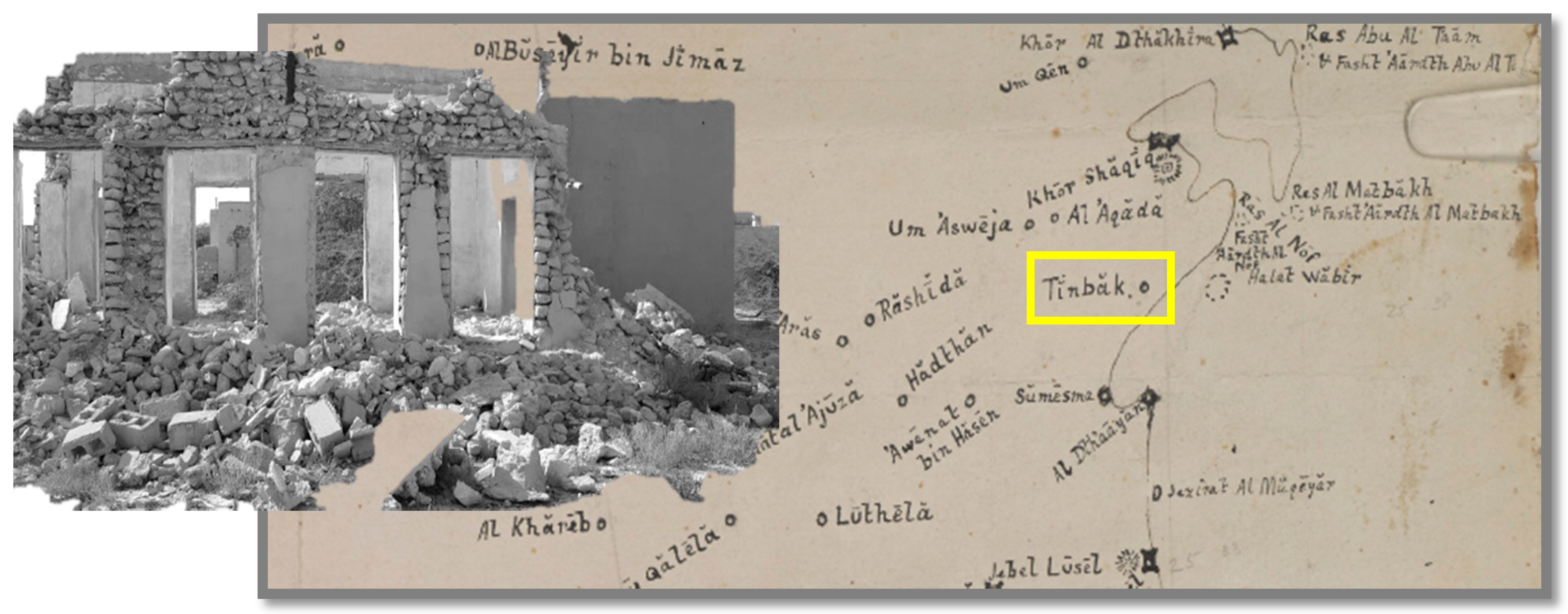
One of the earliest mentions of Tinbak in 1908 is by Lorimer, who reported it as a Bedouin camping ground inland with a fort 4 miles south of present-day Al Khor and close to the coast. He also mentions that six masonry wells sunk into the stony ground at a depth of 10 m, yielding good water. The towns of Aswaija (Umm Suwayya), Agoda (Al Uqdah), Sumaisima and Tinbak (Figure 1 and Figure 2) were also mentioned in the earlier map of the 1930s drawn by the Bushire Political Residency [17].
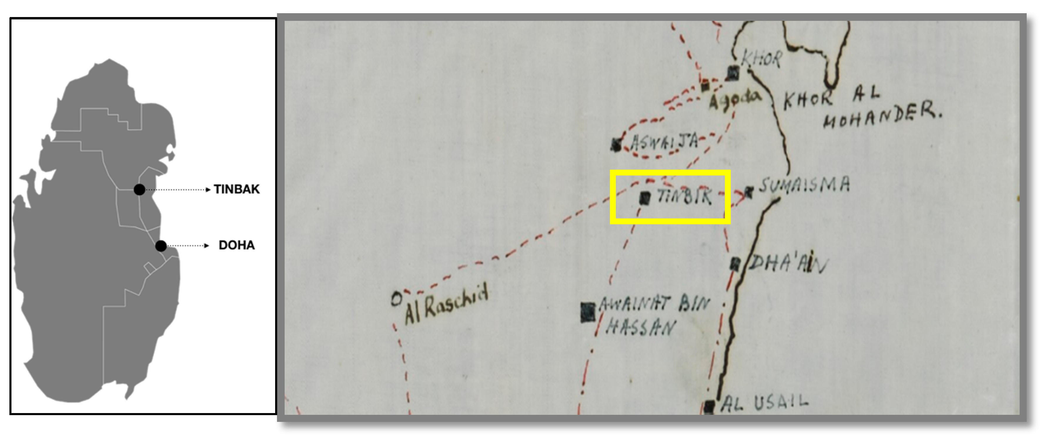
The old village of Tinbak is on the north-eastern shore of Qatar with the coastal road to its east. The distance from the village to the center of Doha is about 55 km. The village is part of the Al Daayen municipality. Tinbak is also known as Tinbij in the native Qatari dialect. Tinbij is an Arabic word that describes a land where groundwater naturally surfaces.
Tinbak is a historical site in Qatar with distinct heritage, culture, and traditional architecture, reflecting the richness and diversity of Qatari civilization [18]. There are very few detailed historical records of the village. However, previous residents of Tinbak were interviewed to understand the origins of the village. Based on our interview with Mr. Ali Jaber Al-Humaidi (Ali, the son of Jaber, the son of Mohammad, the son of Amer Al-Humaidi) on 10 December 2019, a previous resident of Tinbak, the first man to come to Tinbak was Mohammed, son of Amer Al-Humaidi who moved from Al-Daayen to Al-Ghaf because of the downfall of pearling. The Great Depression of the 1930s and the invention of Japanese cultured pearls had deteriorated the livelihood of pearl divers in Qatar. Mohammed built two rooms in Tinbak and bought a farm from a man of the Al-Kaabi tribe in 1936. He insisted on settling in Tinbak, especially after the famine in 1936–1948. During the famine, some residents of Qatar moved to Bahrain, and some travelled overseas to Saudi Arabia, including Jaber Al-Humaidi. He returned in 1946 and settled with his uncle Mohammed Amer Al-Humaidi. Later, the rest of the families who travelled to Bahrain came back and settled in Umm Qarn and Al-Khor. Abdullah, the son of Mohammed Amer Al-Humaidi settled down in Sunai Al-Humaidi village in 1946. They stayed in Tinbak until 1967, when they moved to new houses provided by the government. The residents named the newly built area “Modern Tinbak” because of its contemporary design and construction. The villagers used electric generators and gas lanterns before the government-supplied electricity and water mains to the village in 1973.
3. Methodology
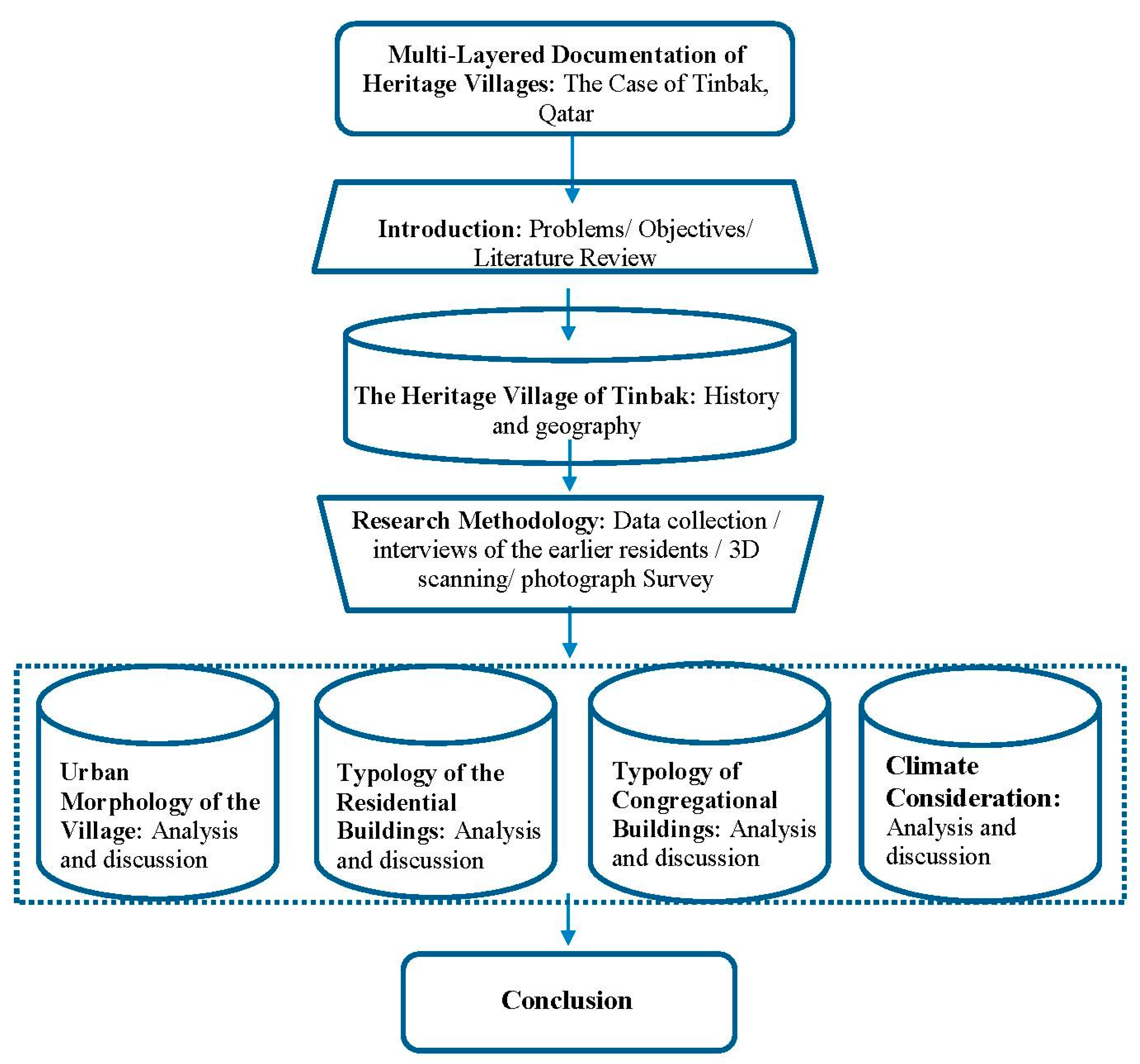
The main intention of the research is to study the distinctiveness of Tinbak village and explore its urban typology to suggest conservation strategies, including revitalization, rehabilitation, renewal and regeneration. The focus is on the urban typology, architectural features and vernacular architecture components using photographic evidence, detailed interviews and 3D scanning. Twenty-two houses were surveyed in the study, with a detailed analysis of individual structures. In addition, the study examines the interrelations between the physical characteristics of the buildings and the users, the earlier inhabitants of the village. The analysis is descriptive. It combined a detailed analysis of the traditional and vernacular built forms, layouts of open spaces, social behaviour and interaction with animal domestication and farming activities. Figure 3 is the flowchart of the research.
The field surveys were carried out from September 2019 to June 2020. Nearly 22 existing structures in Tinbak, both good and slightly deteriorated conditions, were chosen for the survey. Detailed interviews were carried out with village elders who had many years of their life spent in Tinbak. 3D scanning was used to produce a set of architectural drawings and photographic observations for a detailed analysis of individual architectural elements. The following are four sections discuss
4. Urban Morphology of the Village of Tinbak
Old settlements are a form of imprinted history of historical inhabitants [19]. The early urban settlement reflects the culture, with buildings and streetscapes carrying stories of prosperity and difficulty [20]. Urban layouts represent the thought and space philosophy of inhabitants [21]. A place for inhabitants depends on the harmony between the functional requirements, urban layout and street amenities [7]. Understanding the relationship between the users and the built environment is essential to determine people’s satisfaction and attachment to the place [22]. Therefore, studying the typology of Tinbak’s buildings requires an understanding of the village’s spatial distribution relative to function and the relationship between buildings and open areas [23]. The analysis of this section covers three main aspects: the urban morphology, architectural typology, and the distribution and social logic of spaces.
As seen in Figure 2, Tinbak was close to other towns of importance, namely Al Uqdah on the north, Sumaisima on the east and Awainat Bin Hassan on the south. Roads connecting these towns formed the major entryways to the village. Tinbak extends over an area of about 24 hectares, surrounded by farms from three sides. Figure 4 and Figure 5 show the master plan and land-use map of the village. The map depicts the morphological components where stone fences define the boundaries of houses and courtyard spaces separating houses from each other. The land use map illustrates the following deductions:
- (1)
- There are three types of open spaces: linear spaces forming the street network, public squares with undefined edges and confined spaces made up of private residential courtyards contained by fences and rooms.
- (2)
- The linear spaces were for circulation, consisting of a ring road defining the perimeter of the boundary (sikka), an inner way (zikkak) and a walkway (dakhous).
- (3)
- Buildings represent the residential zone and the public zone.
- (4)
- All residential and public buildings are one storey high.
- (5)
- Electric rooms and garages were a late addition in the 1960s and 1970s.
- (6)
- Cow sheds, camel pens and hawk sheds were all a part of the economic life in the village. The villagers had cows to sustain them for milk and meat, camels for travelling and hawks for training as a sport.
- (7)
- A water tank in the middle of the crossing road was for resting camels.
- (8)
- The village contains several trees scattered throughout. The trees are native to Qatar and grow naturally due to the presence of existing higher groundwater tables.
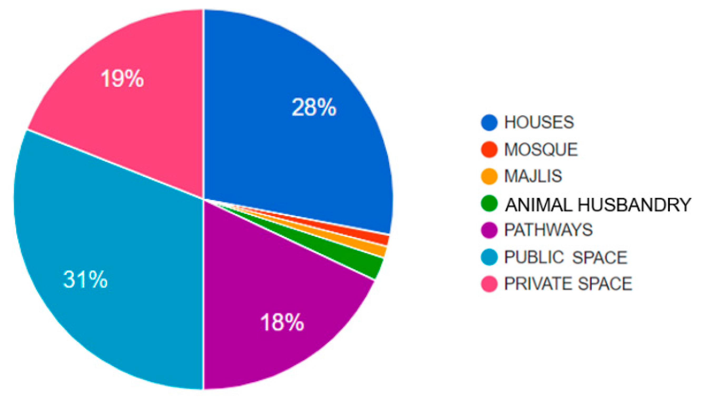
The land-use plan shows that all plots are rectangular and almost all courtyards are irregular. All the public buildings are located on the periphery and connected by a ring road. The location of the public buildings keeps them separated from the residential area. The plan also shows how the transformation from private to public occurs through the semi-private or semi-public zone. The necessity of the hierarchy of urban zones is confirmed by the sociologist Newman [24], who finds that the absence of the transitional zone increases crime and street vandalism rates. In Tinbak, the semi-public and semi-private zones are essential transitional zones to maintain security and privacy. The space syntax is accentuated by different characteristics of both the public building and residential space. This urban hierarchy is a semiotic presentation that discourages outsiders from penetrating the residential area [7]. Table 1 compares the spaces in each building in Tinbak, while Figure 6 compares the land use functions in the village as a whole. Tinbak has 18 houses, with their courtyards occupying 47% of the village area. The residential buildings with their courtyards form a low-density settlement. The public buildings, consisting of a mosque, animal domestication spaces and three majales (guest halls) take up only 4% of the village.
As mentioned earlier, the village did not grow beyond its first stage of development. The circulation network was a result of footmarks of the inhabitants who tended to take the shortest path to their destination. Paths were thus edgeless, poorly defined and irregular trails that, in the residential area, formed a hierarchical sequence of wide to narrow spaces with direct links to most buildings. Figure 7 shows three pictures of the circulation network’s hierarchy. The left picture shows the primary road or the outer ring road; the middle picture shows an inner path measuring up to 7.5 m, which is wide enough for animals such as cows, donkeys and camels to pass through; and the right picture shows a narrow pedestrian pathway between two buildings. Circulation in Tinbak occupies 18% of the total village area while public spaces occupy 29%, combining 48% of the village area. The sizable proportion of circulation and public space in the village indicates the importance of outdoor social interaction.
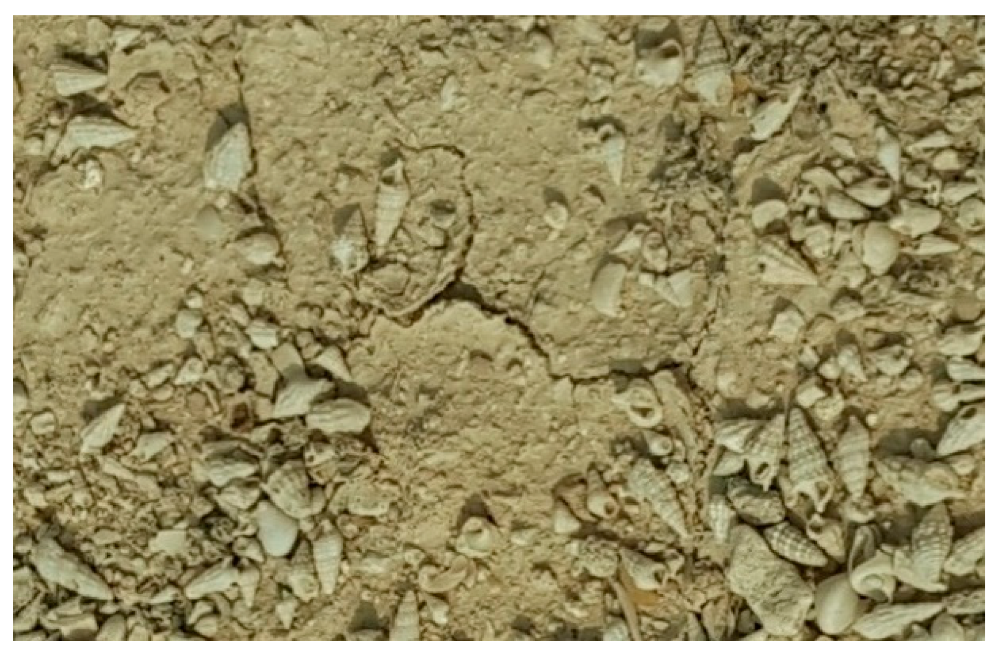
The paving material of the circulation network and public spaces is a mix of shell and sand called subaan (Figure 8). Subaan is an abundant material commonly used as a top layer for open spaces and courtyards in old coastal villages. The weight of subaan is sufficient to resist sweeping away by the wind.
The village did not have shops, so residents travelled 4 km north to meet their needs for sustenance from Al-Khor city. This problem is the reason behind the food storage rooms in each house with an average size of 6 m2. The master plan (Figure 5), Table 1, and pie-charts (Figure 6) are the primary data for discussing building typology in the following section.
5. Typology of the Residential Buildings
Since a single tribe inhabited Tinbak, Al-Humaidi, the houses belonged to the kith and kin of the family members. Each house had an average of five family members, sometimes including workers from Africa. Tinbak used to bring young Africans to help in pearl-diving, farming, trading, or looking after livestock. According to the villagers, these African workers were treated as family members and held the surname of the employers. As a result, they had houses that were identical in size, layout and inseparable from the residential fabric. This is evident when comparing building 4 (Figure 5), which was occupied by an African family, to the rest of the village houses. An African family consisted of a couple with two adult sons, each with their room, occupied building 4.
If someone in the village had a second wife or an old dependent relative, a separate house or room was built, usually attached to the main household (See buildings 6 and 8). For example, building 8 consisted of a detached single room outside for the mother-in-law of Sultan, house 6. Another interesting finding was that the house of each family member (like a married son) typically consisted of one or two rooms with ancillary facilities such as a kitchen and a storage room that, in some cases, were shared with a nearby house. Buildings 6 and 7 shared the same kitchen and storage room, for example.
The villagers laid out their houses to access neighbouring houses through permanent openings in the exterior partition wall. The porosity between houses is an indication of the close relationship between inhabitants. Each house maintained its privacy while benefitting from the kinship of their relatives in the adjacent buildings. Tinbak, as a case of traditional buildings in Qatar, followed the principle of an enclosed private family space organized around a central open courtyard, which may contain a small garden and tree. Any building addition had to relate to the courtyard directly and maintain its sense of spatial enclosure.
The organization of each house was based on multiple functional rooms built beside each other for different usages. They were arranged around an open courtyard, leaving space for an indirect entrance to all rooms to provide more privacy for the family members. The summation of all rooms beside the courtyard formed a house that typically had at least one or two rooms at the ground level. Figure 9 shows the percentage of various functional rooms in all houses that occupy 46% of the overall village area. The following is a list of design principles found in Tinbak’s house typology:
- (1)
- Rooms are arranged along the perimeter of the courtyard.
- (2)
- Each house contains one or two multi-purpose rooms used during the day for living and during the night for sleeping. There is also a bathroom accessible directly from one of the rooms. The rooms and bathroom occupy 26% of the house area.
- (3)
- Each house has two service rooms, a kitchen and storage, which occupied 6% of the house area. Both rooms have direct entries from the courtyard. The kitchen is a standalone room with an average size of 17 m2 accompanied by a sink on the ground to wash cooking vessels and utensils. Small households, like buildings 6, 7 and 8, share one kitchen between them.
- (4)
- Food storage rooms are essential to each house because it is challenging to collect food daily. The storage rooms are attached, forming one structure. They are generally smaller than the family room and the bedrooms. In a few cases, the kitchen shares walls with the neighbouring buildings.
- (5)
- Buildings 4 and 9 each have a ‘majlis (guest hall) connected directly to the main entrance and serves as a reception room for male guests. An attached majlis is not necessarily a reflection of a household’s social status. Other houses like Sultan and Jaber (building 3), have a detached majlis from the house despite the family’s respected social status.
- (6)
- 65% of the residential buildings have liwan, a colonnade. These are buildings 5, 6, 7, 8, 13, 14, 15, 16, 17, 19 and 20. The liwan is a shaded area lining the rooms that form a smooth extension of the living room and is an excellent outdoor seating area.
- (7)
- Each of the buildings 8 and 10 has a sink on the ground of the courtyards for washing utensils. These outdoor sinks were used for a major cooking event.
- (8)
- Buildings 4, 6, 8, 13, 19 and 20 have secondary accesses for family members.
- (9)
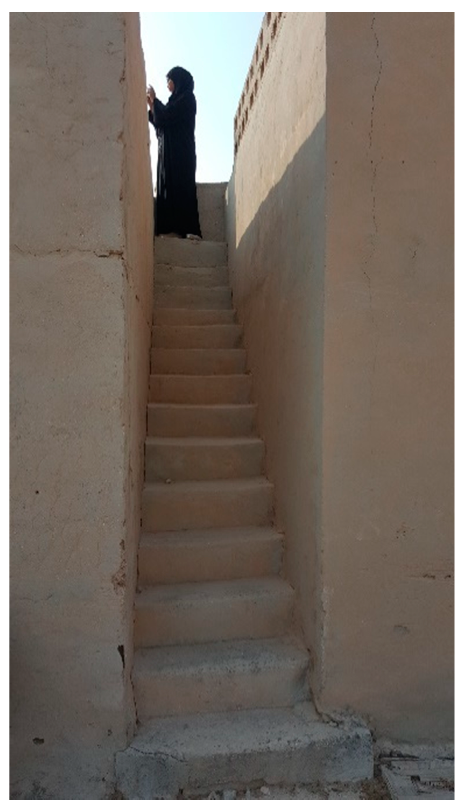
- Buildings 4, 8, 9 and 15 have external staircases leading to the rooftop (Figure 10). Access to this staircase has no door. The staircase is located either between two rooms or stands beside an outer wall. The staircase has a width of 70 cm, and the heights of the steps are irregular, ranging from 20 to 40 cm.
- (10)
- Buildings with staircases have roof parapet of three rows of 20 by 20 cm screen concrete blocks. These screens allow wind to blow through the roof and cool it. As a manifestation of socio-spatial culture [25], roofs are sometimes places for sleeping or spending time during cool summer nights.
- (11)
- Animal domestication is a traditional critical characteristic of the household. The village has cowsheds, camel pens and hawk rooms. There are three cowsheds in the village, the largest of which can hold ten cows. Everyone in the village used the sheds until some houses built their own (buildings 8 and 9). There is only one camel pen in the village that is large enough to fit 2–3 camels. Villagers used camels for transportation and to carry water from wells. There is one hawk pen with a size of 3 by 5 m.
- (12)
- The entire village depended on wells for their daily freshwater needs, whether for cooking, bathing, or drinking. The village has one well in building 16, the imam’s house. As mentioned in the introduction, Tinbak took its name from its abundant groundwater. Outside the village, there were three wells used by the residents of Tinbak and other nearby villages. The well was an essential spot for socialization and exchanging news among those fetching water [26].
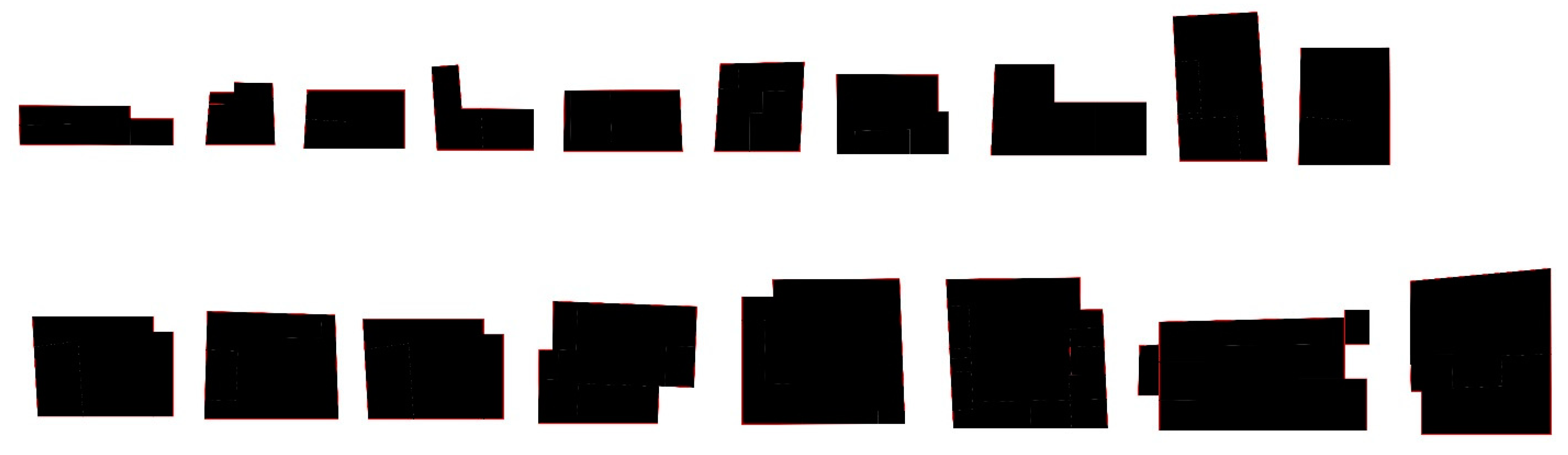
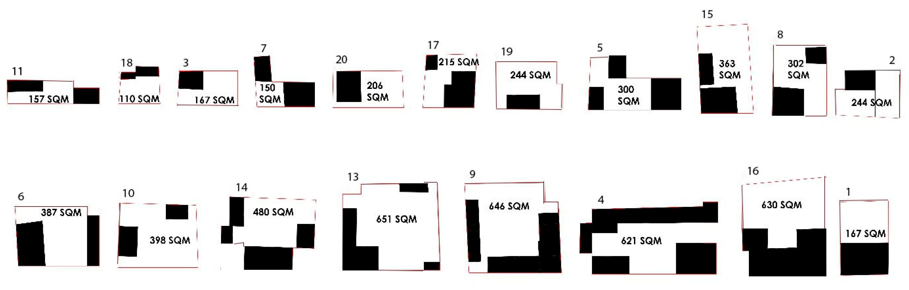
In Tinbak, building 21 was the only house without a courtyard because it consisted of one room. An analysis of the layout of the other 18 courtyard buildings helped to understand the organizational principles of rooms. The attached rooms represented a structure. Housing rooms were laid out next to each other with respect to functional requirements. The majority of the houses had an average area of 300 m2. Only four houses reached exceeded 600 m2: buildings 7 (806 m2), 9 (629 m2) 13 (649 m2) and 16 (625 m2). Each house belonged to a single family or an extended family where one family occupied a cluster of rooms. The houses had regular geometrical shapes with additions or subtractions around their edges (Figure 11 and Figure 12). Some houses took the form of L shaped structure. The rooms began at the edge or corner of the boundary of the house. They were gradually elongated with additional rooms on the opposite or diagonal edges of the property. Additional rooms were built either for the family or livestock. The storage room and kitchen were usually centrally placed between rooms.
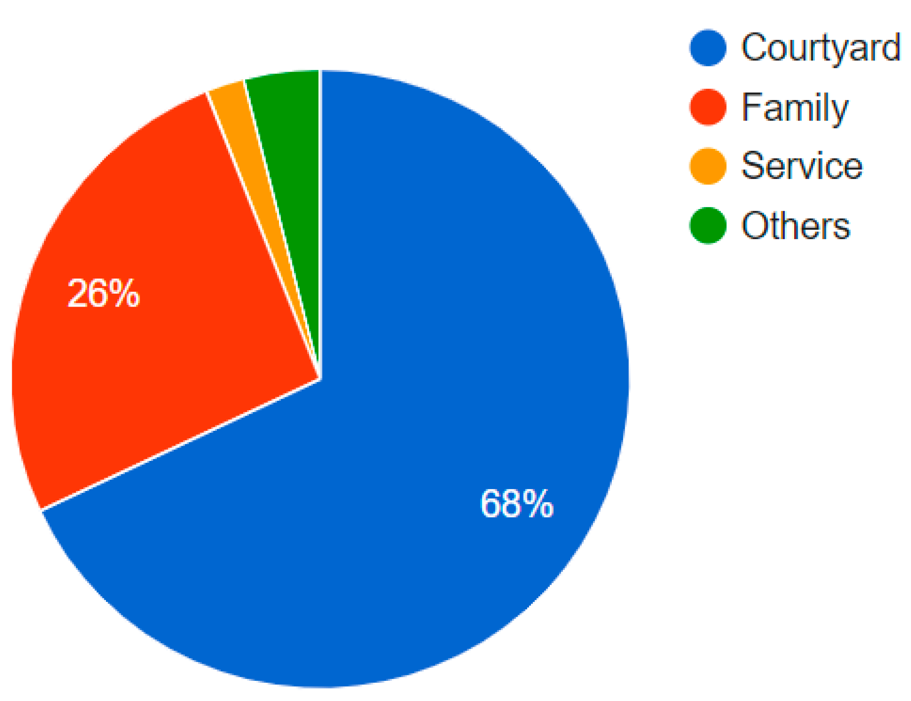
Courtyards were the most critical spaces in the home. They took up an average of 68% of a house’s total area, an indication of their vital role in daily life. Due to the nature of courtyards as central open spaces, all rooms were accessed through them. Additionally, courtyards were ideal spaces for the future expansion of a house, allowing for flexibility to accommodate a growing family. Therefore, courtyard sizes were decreasing over time as a result of the expansion. The courtyard was ideal for children and women to carry out daily activities and evening gatherings or entertaining guests.
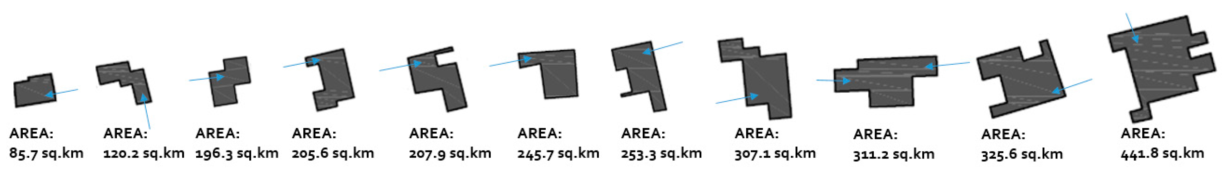
Around the courtyard stood single rooms for various functions, resulting in irregular shapes (Figure 13). Only building 12 had a rectangular courtyard with minor deviations along its edges. House entrances opened directly onto the courtyards. Most of these houses had only one entrance; however, two entries were observed in buildings 7, 9, 13 and 14.
6. Typology of Congregational Buildings
Tinbak, as a small community, consisted of relatives from different generations. It was an enclosed settlement with strong family ties to the point that, as mentioned above, the shared fences between neighbours had open gates so they could visit each other without knocking at doors. There were four congregational buildings on the village level, 3 majales (building 2, 3, 12) and a mosque (building 1). Even though the congregational zone formed 4% of the total village area, they were important places. The congregational spaces were frequently used for general gatherings to discuss village matters or meet important guests.
The congregational buildings sat along the peripheral ring road, forming a strip of public space (Figure 4 and Figure 5). The location helped provide access to outsiders while sustaining residents’ privacy in the village who could access the congregate buildings through the inner pathways. In addition, the congregational buildings had courtyards through which people accessed the interior rooms. The villagers used these and courtyards for informal day or night conversations.
The mosque is located on the northwest corner of the village, with access from the ring road and away from the housing cluster. The mosque signifies its importance as a landmark, ear-mark (during the azan, five times declaration for prayer) and religious center (Figure 14). It consists of five major areas and elements: the haram (prayer hall), a mihrab (the niche where the imam leads the prayer), a courtyard, liwan (colonnade) and a minaret. Compared with typical mosques in the Islamic world, four other elements are missing in Tinbak’s mosque: the minbar (a few-steps-high structure on the right of the mihrab for preaching), an ablution area, a dome, and a central water fountain in the courtyard.
The liwan is connected directly to the east of the haram by three doors centered symmetrically. As a covered area of 4 by 10 m, the liwan serves two purposes: an extension of the haram for when the number of worshipers exceeded the haram’s capacity, and an outdoor prayer area and social space on days of moderate temperature. On the east of the liwan extend the courtyard of 148 square meters, a space large enough to host all residents of the village. A decorated concrete fence surrounds the courtyard with an entrance on the east side proceeded with three steps up. Like all open spaces in the village, the courtyard’s ground is covered with subaan (the shell-sand mixture).
The haram has two wooden window openings along the south wall and another two on the north wall. Similarly, there are other four wooden windows located in the liwan. Each of the windows has operational sashes and seven round vertical metal bars fixed on the outer side in each of the eight windows. The windows inside the haram are also fitted with operable shutters.
The mihrab, the niche where the imam leads the prayer, was centered on the long southwest wall of the haram. The mihrab and haram aligned to the direction of Mecca, where all Muslims face during prayer. The mihrab in Tinbak mosque projected out of the exterior wall, which helped people on the street orient themselves geographically. To prevent distracting or interrupting worshipers in the haram, entrances must be from the wall opposite the mihrab.
The mosque in Tinbak has a flat roof without a dome that is a typical feature in many other mosques. The philosophical explanations about the symbolism of the dome, which is a reflection of the sky, are therefore absent in Tinbak mosque. The flat roof has its meaning; it reminds users of the first mosque built during the Prophet Mohammad (PBUH) life, who discouraged interior ornamentation to avoid distracting worshipers from their prayers. Tinbak mosque, therefore, represents an ideal minimal design.
The most prominent element of the mosque is the minaret. It is a separate structure on the northeast corner of the courtyard, similar to the typical traditional Qatari minarets (Figure 14). The minaret served three purposes: as a public landmark, the symbolize Muslim settlements and a platform for the azan (the Muslim call to ritual prayer) at the top of the tower. The cupola of the minaret had a dome supported by six identical pointed arches.
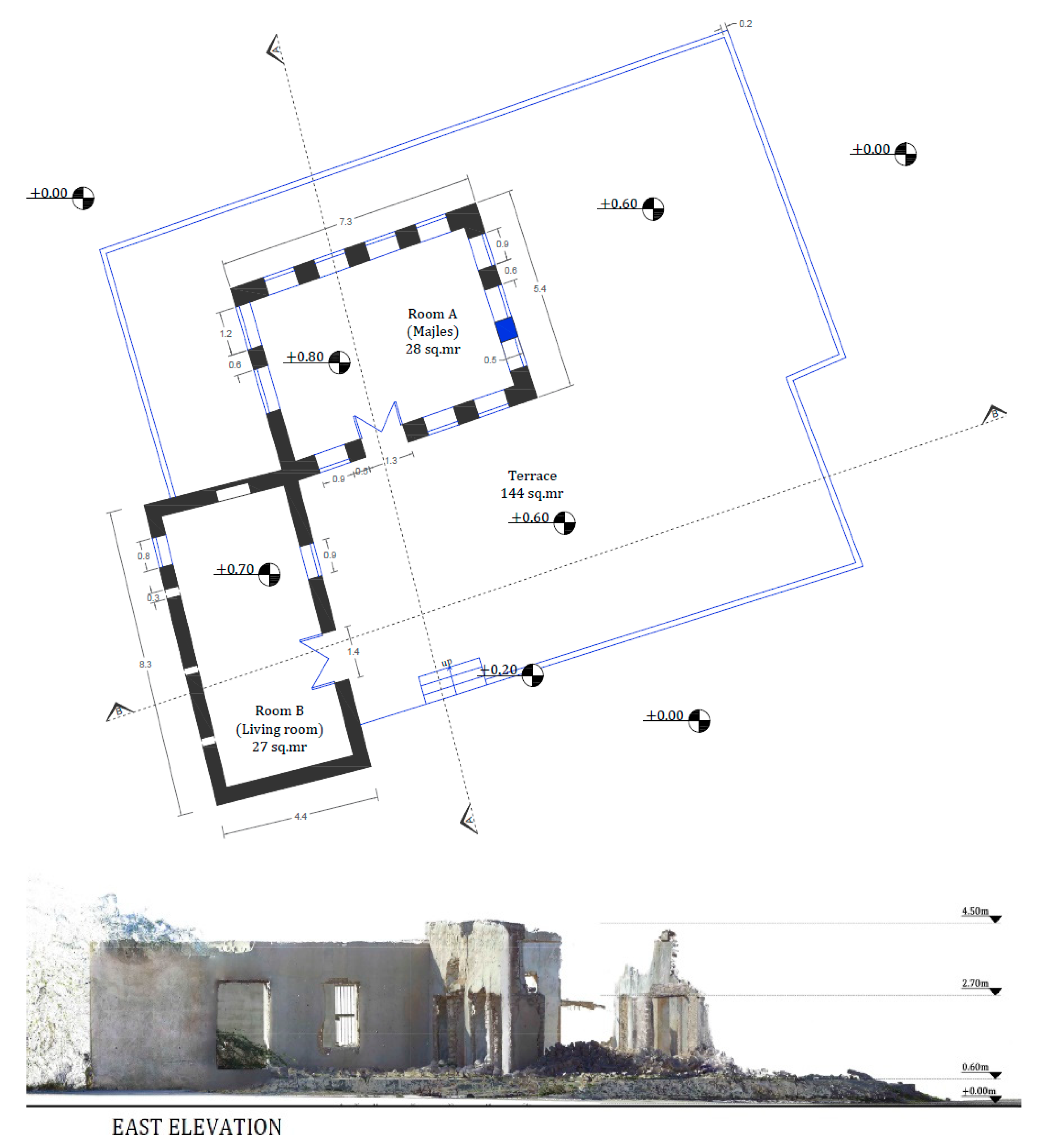
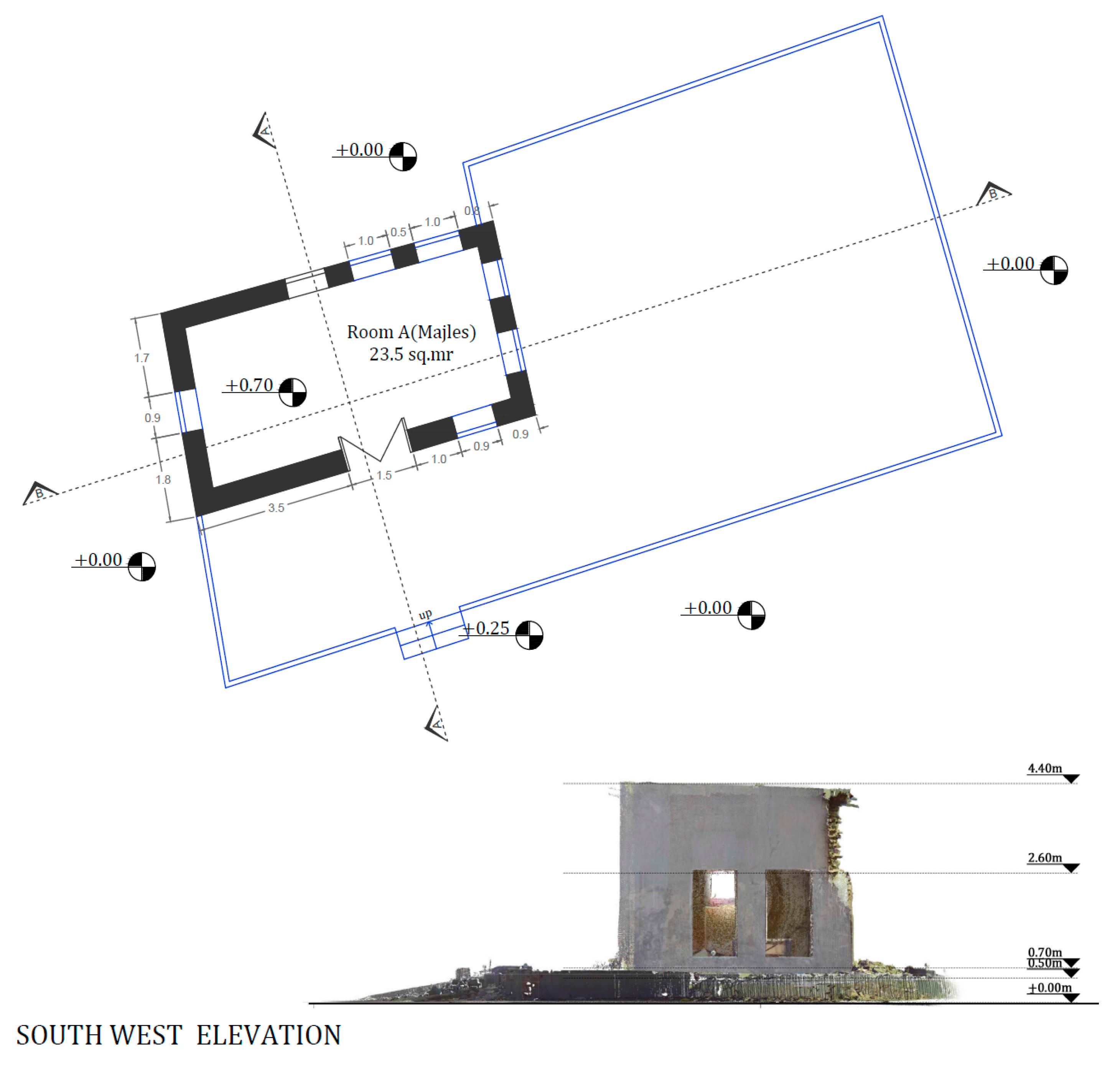
The majales are private or public gathering spaces. The public majales are detached structures found in the public spaces, while the private majales are either detached or attached rooms within a house compound. The village’s main public majlis (singular) is building 2, next to the mosque (Figure 15). The majlis served as a place for reception, ruling, trading, schooling and cultural gathering, especially in the Winter. In large settlements, the majlis contains a washroom, a bathroom for guests, a kitchen, a dining area and a seating area. In Tinbak, the majlis is just 28 m2 and had many large windows a terrace as privacy is less important than in houses, and extra natural light is needed. The public majlis has a side door leading to a terrace open towards the east and another room for multi-functional use. Like other majales, it is elevated by one step of 20 cm above the street level. The entry doors of the majlis have a low height of just 170 cm, forcing people to bow down before entering. The architectural details of the windows are similar to the ones in the mosque. The roof is flat with no parapet.
7. Climate Consideration
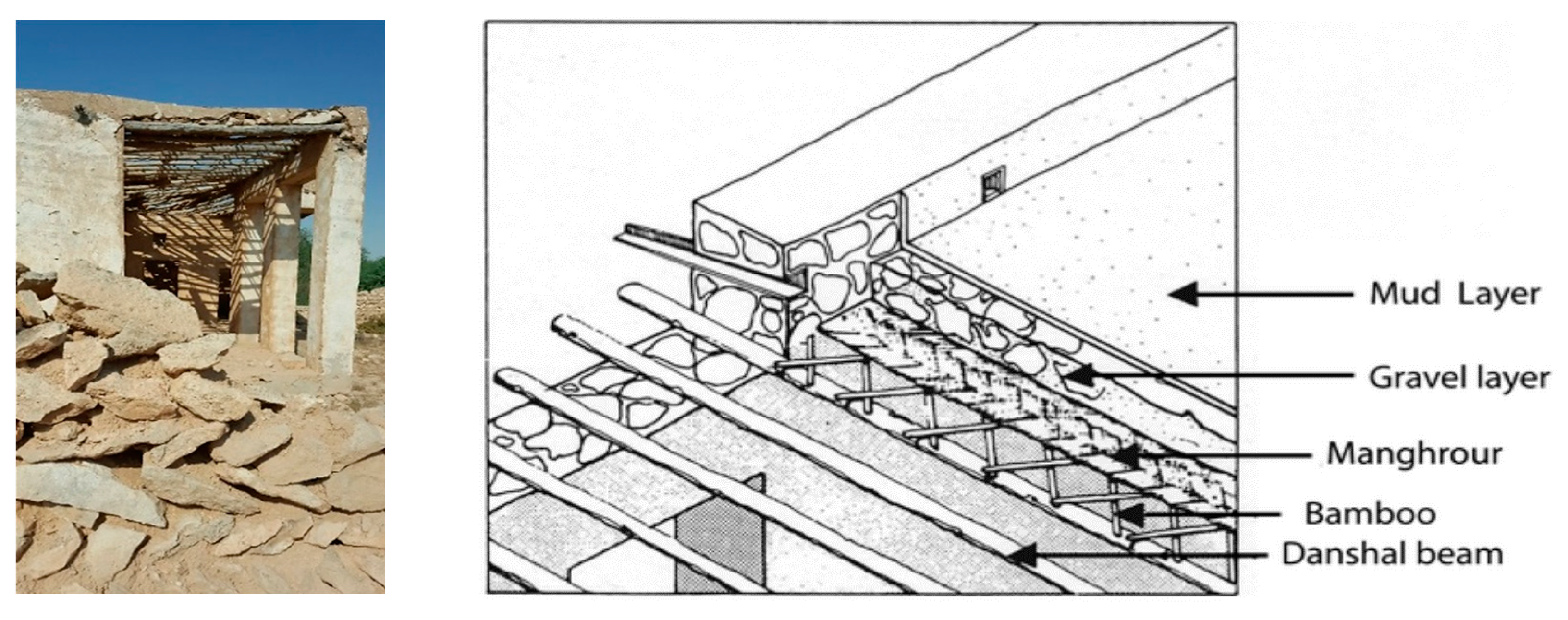
In studying the architecture of Tinbak, we can find many design solutions to mitigate the severity of the region’s hot climate. First, the settlement’s layout shows a responsive design to the prevalent northwest wind. Research on Bedouin tents has emphasized the importance of campsite orientation and entrance locations in shielding tent dwellers from wind and allowing light to come through the doors (Montigny 1983: 7; Macumber 2016). In Tinbak, the back of buildings faced northwest, possibly to protect against the prominent northern wind. There is little consistency in the orientation of doors, however. Second, the construction of 60 cm thick stone walls helped reduce the heat conductibility as a thermal mass (Figure 16).
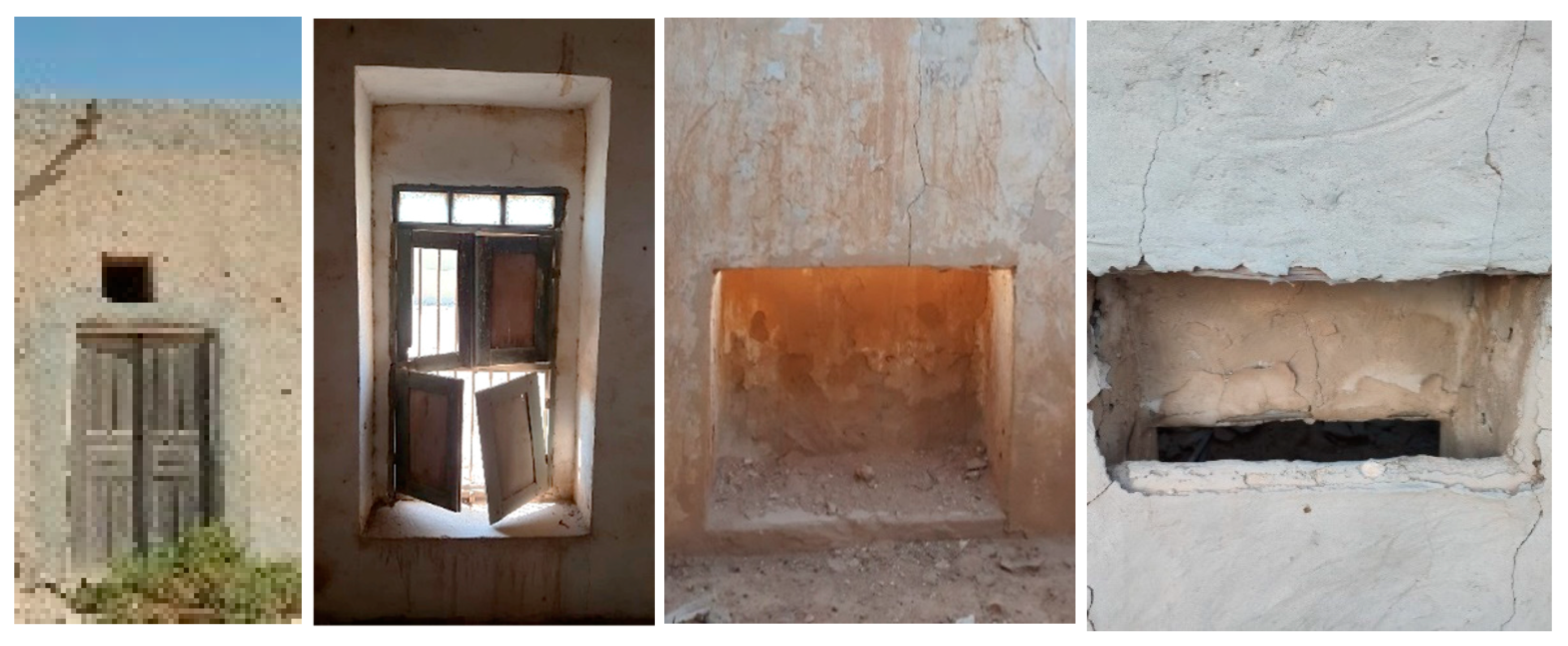
Third, the position of the shaded liwan before all rooms helped avoid direct sun exposure and glare. Fourth, operable doors and windows ensured cross-ventilation, especially in public buildings. They placed small permanent puncture openings above the door in several cases, contributing to the airflow through the room once the windows were open (Figure 17, Picture 1). Some buildings had windows on multiple walls, as was the mosque’s prayer hall or the majales. Fifth, people sat on the ground where it was the coolest in the room, taking advantage of cool airflows when the windows were open. Windows had low sills of 20 to 50 cm above the ground to have the air circulation match the seating etiquette. Sixth, as explained in the mosque above, windows had shutters to control the amount of sunlight entering the room and maintain resident privacy (Figure 17, Picture 2). Seventh, wind catchers (malqaf) were prevalent in the region as structures that brought wind into buildings. In Tinbak, only one wind catcher was found in building 14 where the malqaf was at a lower room level. Figure 17, Pictures 3 and 4 show the windcatcher from both inside and outside. Eighth, the courtyards found in most buildings along with ground fences and trees reduced undesired wind and helped create a cooler microclimate within each building. Ninth, the subaan land cover of sand and shell reduces the albedo effect by 35%–48% because of its light brown colour and rough surface [4]. Tenth, rooms had few windows, usually one, helping control the heat flow. This, along with the thick stone walls, leads to a measured drop in temperature of 3–5 degrees inside from the outside.
In the 1960s, electricity was introduced in the village, but few cases of its use. One was the use of fans in the haram of the mosque and openings for window air conditioning units. Because electricity was introduced after these buildings were built, electrical power and air conditioning were not typical and showed no influenced change in the design of the traditional buildings. With the absence of air conditioning, people continued relying on natural ventilation and passive cooling.
8. Conclusions
This paper is part of ongoing research to provide, for the first time, full documentation of the abandoned village of Tinbak. In this paper, we focus on the urban morphology and building typologies of Tinbak. Our methods include drawing a master plan of the village, architectural drawing documentation, a record of photos by frequent site visits, and complete 3D scanning. It also includes meeting previous residents to orally document and defines the social dimension of the village.
The documented village extended over about 24 hectares and is surrounded by farms on three sides. It consists of 18 houses forming the private zone of the village. The public zone contains four congregational buildings, a mosque and three public majales. There are also two later additions of electricity-generator rooms; the first was used in the sixties of the last century and the second in the seventies. The boundaries of Tinbak need to be reaffirmed since the early written records indicate the presence of several wells with fresh groundwater within the village boundary.
The morphological analysis of Tinbak shows that the residential houses consisted of two or three rooms and a bathroom typically built between rooms and arranged around irregular courtyards. The rooms were usually used for living during the day and for sleeping during the night. An adjacent covered colonnade space, the liwan, acted as an extension of the room and overlooked the courtyard. Moreover, the houses had separate structures for kitchen and food storage. The congregation buildings stood on the perimeter of the village for easy access by both villagers and visitors. The mosque consisted of four main elements surrounded by an external fence: the haram (the prayer hall), the courtyard, the mihrab and the minaret. The public majlis consisted of a large guest room with several windows and a courtyard.
Shedding light on the functional and morphological aspects of the village is just one dimension in the documentation of the village characteristics. Additional studies are needed to explore both the visual and social dimensions for a holistic conservation proposal of Tinbak. One of the pillars of the tourism industry has been mankind’s inherent desire to see and learn about the cultural identity of different parts of the world [28]. This study is a step towards conserving the village as an environmentally feasible and significant sustainable development. As a suggestion, the abandoned village of Tinbak is an ideal place for eco-tourism. It requires revitalization and a strategic plan to convert the heritage village into a rural eco-tourism site due to its surroundings.
Author Contributions
Conceptualization, M.S.F.; M.A.-H. and S.E.-M.; methodology, M.S.F.; K.L.M.; software, K.L.M.; validation, M.S.F.; M.A.-H. and H.A.A.; formal analysis, M.S.F.; investigation, S.E.-M.; resources, M.S.F.; data curation, M.S.F. and H.A.A.; writing—original draft preparation, K.L.M.; writing—review and editing, M.S.F.; visualization, M.A.-H. and S.E.-M.; supervision, M.S.F.; project administration, M.S.F. and S.E.-M.; funding acquisition, M.S.F. All authors have read and agreed to the published version of the manuscript.
Funding
This work was supported by the Qatar University under Internal Grant # QUCG-CENG-19/20-2.
Acknowledgments
To the previous inhabitants of Tinbak who were enthusiastic about recording all aspects of the old village and added energy to the research team. Additionally, their generosity in providing explanations and descriptions about their life back in Tinbak made it possible to record the observations in the paper. We want to give our special gratitude to Nassir Al-Humaidi, who invited us for a field trip to the village to ensure our acquaintance with all details ranging from previous ownership, day-to-day family activities, and narrating old stories of the place. We want to express our gratitude to Faisal Al-Na’imi, the Head of the Archaeology Department at Qatar Museums Authority (QMA), Ibrahim Jaidah, Group CEO & Chief Architect of the Arab Engineering Bureau (AEB Qatar), and Mohamed Ali Abdullah, Private Engineering Office, for their advice and support with the required resources. Furthermore, we are thankful to the Master Students Labeeb Ali Ellath, the architects Shaden Yousif and Hend Gamal for their enormous assistance.This work was supported by the Qatar University under Internal Grant # QUCG-CENG-19/20-2.
Conflicts of Interest
The authors declare no conflict of interest.
References
- Gates, W.E. The Spread of Ibn Khaldûn’s Ideas on Climate and Culture. J. Hist. Ideas 1967, 28, 415–422. [Google Scholar] [CrossRef]
- Jordan, M.; Meyer, W.B.; Kates, R.W.; Clark, W.C.; Richards, J.F.; Turner, B.L.; Mathews, J.T. The Earth as Transformed by Human Action: Global and Regional Changes in the Biosphere over the Past 300 Years; The Quarterly Review of Biology; The University of Chicago Press: Chicago, IL, USA, 1990; Volume 68. [Google Scholar]
- Bonnemaison, J.; Agnew, J.; Blanc-Pamard, C.; Lasseur, M.; Thibault, C.; Pénot-Demetry, J. Culture and Space: Conceiving a New Cultural Geography; Bloomsbury Publishing: London, UK, 2005. [Google Scholar]
- Shandas, V.; Skelhorn, C.; Ferwati, S. Urban Adaptation to Climate Change: The Role of Urban Form in Mediating Rising Temperatures; Springer: New York, NY, USA, 2020. [Google Scholar]
- Kashef, M. Architects and planners approaches to urban form and design in the Toronto region: A comparative analysis. Geoforum 2008, 39, 414–437. [Google Scholar] [CrossRef]
- Abu-Lughod, J.L. The Islamic city–Historic myth, Islamic essence, and contemporary relevance. Int. J. Middle East Stud. 1987, 19, 155–176. [Google Scholar] [CrossRef] [Green Version]
- Ferwati, M.S. Urban Semiotic Analysis: Spatial Design and Behavioural Relations; VDM Publishing House Ltd.: Düsseldörp, Germany, 2010. [Google Scholar]
- Akbar, J.; Shaw, J. Crisis in the Built Environment: The Case of the Muslim City; MIT Press: Cambridge, MA, USA, 1988. [Google Scholar]
- Salama, A.M.A.; Wiedmann, F. Demystifying Doha: On Architecture and Urbanism in an Emerging City; Routledge: Oxford, UK, 2016. [Google Scholar]
- Murzyn-Kupisz, M.; Działek, J. Cultural heritage in building and enhancing social capital. In Journal of Cultural Heritage Management and Sustainable Development; Emerald Publishing Limited: West Yorkshire, UK, 2013. [Google Scholar]
- Fathy, H. Architecture for the Poor an Experiment in Rural Egypt; The American University: Cairo, Egypt, 2000. [Google Scholar]
- May, J. Buildings without Architects: A Global Guide to Everyday Architecture; Rizzoli: New York, NY, USA, 2010. [Google Scholar]
- Aitken, S.C.; Bjorklund, E.M. Transactional and transformational theories in behavioral geography. Prof. Geographer. 1988, 40, 54–64. [Google Scholar] [CrossRef]
- Peterson, J.E. Tribes and politics in eastern Arabia. Middle East J. 1977, 31, 297–312. [Google Scholar]
- Zahlan, R.S. The Creation of Qatar; Routledge: Oxfordshire, UK, 1979. [Google Scholar]
- Althani, M.A.J. Jassim, the Leader: Founder of Qatar; Profile Books: London, UK, 2012. [Google Scholar]
- Qatar National Digital Library; Bushire Political Residency: Doha, Qatar, 2020.
- History of Qatar; Ministry of Foreign Affairs: Doha, Qatar, 2000.
- Eloundou, L.; Joffroy, T. Earthen Architecture in Today’s World. In Proceedings of the UNESCO International Colloquium on the Conservation of World Heritage Earthen Architecture; UNESCO Publishing: Paris, France; Available online: www.whc.unesco.org/en/series/36 (accessed on 14 June 2021).
- Chatterjee, S. The “Culture of Space”. In Social Science Research Network; Elsevier: Amsterdam, The Netherlands, 2006. [Google Scholar]
- Carmona, M. The place-shaping continuum: A theory of urban design process. J. Urban Des. 2014, 19, 2–36. [Google Scholar] [CrossRef]
- Gifford, R. Environmental Psychology: Principles and Practice; Optimal Books: Colville, WA, USA, 2007. [Google Scholar]
- Micek, M.; Staszewska, S. Urban and Rural Public Spaces: Development Issues and Qualitative Assessment. Bull. Geogr. Socio-Econ. Ser. 2019, 45, 75–93. [Google Scholar] [CrossRef] [Green Version]
- Newman, O. Creating Defensible Space; Diane Publishing: Hensonville, NY, USA, 1996. [Google Scholar]
- Al-Kholaifi, M.J. The Traditional Architecture in Qatar, Doha: National Council for Culture, Arts and Heritage. In Museum and Antiquities Department; Griffin Books: Stamford, CT, USA, 2006. [Google Scholar]
- Rapoport, A. Human Aspects of Urban Form. Towards a Man-Environment Approach yo Urban Form and Design; Pergamon Press: Oxford, UK, 1977. [Google Scholar]
- Eddisford, D.; Carter, R. The vernacular architecture of Doha, Qatar. Soc. Post-Mediev. Archaeol. 2017, 51, 81–107. [Google Scholar] [CrossRef]
- International Conference on Cultural Tourism: A report on the International Conference on Cultural Tourism, Siem Reap, Cambodia, 11–13 December 2000/WTO; Description: Madrid, Spain, 2001; p. 217. ISBN 9284404843.
Figure 1.
A map of Qatar in 1934 by a British political agent (Qatar National Digital Library, 2020). The image to the left is a building ruin in Tinbak (Authors).
Figure 1.
A map of Qatar in 1934 by a British political agent (Qatar National Digital Library, 2020). The image to the left is a building ruin in Tinbak (Authors).

Figure 2.
A map of Tinbak in 1937. It stands as an important town. Red dashed lines refer to the routes traversed by foot among different settlements. (Right: Qatar National Digital Library, 2020; left: MME, edited by the Authors).
Figure 2.
A map of Tinbak in 1937. It stands as an important town. Red dashed lines refer to the routes traversed by foot among different settlements. (Right: Qatar National Digital Library, 2020; left: MME, edited by the Authors).

Figure 3.
The research flowchart.

Figure 4.
The 3D scanning of the existing structures of the village resulted in this master plan. It also shows an example of a 3D scanning for residential building 7 showing in blue the courtyard and the room in white. The house had an area size of 769 m2.
Figure 4.
The 3D scanning of the existing structures of the village resulted in this master plan. It also shows an example of a 3D scanning for residential building 7 showing in blue the courtyard and the room in white. The house had an area size of 769 m2.

Figure 5.
Land use map of the village of Tinbak with assigned numbers for discussion in the text. The map shows several points, One: Each house has a courtyard that can be used for additional rooms to accommodate the increasing number of family members; Two: The low height of fences of the courtyards, with an average elevation of 140 cm, makes the open public areas look like an extension to the courtyard, the private space; Three: The village lack greenery; Four: The mosques are set at the village’s periphery to prevent outriders using the mosques from penetrating the private domains of the village.

Figure 6.
The pie chart indicates the percentage of different land use areas. The summation of both the public spaces and the pathways occupy 48% of the village area that is almost equal to 47%, the sum areas of the houses and their private spaces (courtyards). The remaining land uses only 5%.
Figure 6.
The pie chart indicates the percentage of different land use areas. The summation of both the public spaces and the pathways occupy 48% of the village area that is almost equal to 47%, the sum areas of the houses and their private spaces (courtyards). The remaining land uses only 5%.

Figure 7.
Illustrates three examples of the hierarchy of the circulation network. It shows, from left to right, the ring road or the primary (Sikka), an inner road (sikkak) and a pathway (Dakhous).
Figure 7.
Illustrates three examples of the hierarchy of the circulation network. It shows, from left to right, the ring road or the primary (Sikka), an inner road (sikkak) and a pathway (Dakhous).

Figure 8.
The use of subaan as a cover for courtyards and public spaces.

Figure 9.
The percentages of the functional units of the residential buildings.

Figure 10.
Staircase in house #9 in between the southern rooms.

Figure 11.
Compound houses arranged according to areas.

Figure 12.
Configuration of units within each block showing the unit positioned mainly along the edges of the house.
Figure 12.
Configuration of units within each block showing the unit positioned mainly along the edges of the house.

Figure 13.
Courtyard forms are arranged according to areas. Entry points are marked in blue arrows.

Figure 14.
Tinbak Mosque, its plan with a 3D sectional view for the mosque displaying, from left to right, the haram, colonnaded area and part of the courtyard. Moreover, two perspectives; the upper right one is Tinbak Mosque. The lower right one (the black and white) is a view of a typical mosque similar to that in Tinbak (printed with permission from the author Jaidah and Bourennane, 2009).

Figure 15.
Two plans of two Majales with their facades: building 2 on the right and building 3 on the left. Notice the excessive use of windows in the main hall of both majales. The drawing is a result of 3D scanning by the authors.
Figure 15.
Two plans of two Majales with their facades: building 2 on the right and building 3 on the left. Notice the excessive use of windows in the main hall of both majales. The drawing is a result of 3D scanning by the authors.


Figure 16.
The left picture shows the use of colonnade that shade; additionally, it illustrates the roof structure. The right picture shows a detail of the roof and wall structural system. After Al-Kholaifi, [25], cited in [27].

Figure 17.
From left to right, Picture 1 shows a permanent opening above the room entry door used for cross ventilation. Picture 2 shows the details of the window. It has four shutters to reduce the daylight and to provide privacy. In addition, there is a row of three fixed glass panels on the top. Its location above the visual level ensures privacy to the occupants. Pictures 3 and 4 show the malqaf, the first from inside the room and the second from outside.


Table 1.
Comparative analysis of different functional spaces.
| Building No. | Courtyard Space (m2) | Family Area (Rooms) (m2) | Service Area (Kitchen) (m2) | Others (m2) | Total (m2) |
|---|---|---|---|---|---|
| 1 | 314.07 (52%) | 137.15 (23%) | 18.47 (3%) | Cow shed: 99.63 (17%) Majlis: 24.6 (4%) | 593.75 |
| 2 | 196.3 (65%) | 104.4 (35%) | 300.7 | ||
| 3 | 245.5 (63%) | 93.45 (24%) | Hawks farm: 48.25 (13%) | 387.2 | |
| 4 | 666.43 (83%) | 115.85 (14%) | 19.23 (3%) | 801.51 | |
| 5 | 201.09 (68%) | 94.76 (32%) | 295.85 | ||
| 6 | 425.11 (66%) | 198.46 (31%) | 5.78 (3%) | 629.35 | |
| 7 | 136.65 (68%) | 30.13 (15%) | Majlis: 34.33 (17%) | 201.11 | |
| 8 | 365.87 (58%) | 259.55 (42%) | 625.42 | ||
| 9 | 205.82 (84%) | 38.07 (16%) | 243.89 | ||
| 10 | 248.03 (69%) | 113.0 (31%) | 361.03 | ||
| 11 | 309.54 (64%) | 154.84 (32%) | 15.9 (4%) | 480.28 | |
| 12 | 497.6 (77%) | 136.04 (21%) | 15.2 (2%) | 648.84 | |
| 13 | 84.08 (76%) | 26.11(24%) | 110.19 | ||
| 14 | 120.32 (56%) | 81.73 (38%) | 13.15 (6%) | 215.2 | |
| 15 | 327.65 (82%) | 45.05 (11%) | 25.57 (7%) | 398.27 | |
| 16 | 149.5 (70%) | Prayer area: 66.8 (30%) | 216.3 | ||
| 17 | 91.92 (58%) | 65.57 (42%) | 157.49 | ||
| 18 | 137.4 (70%) | 59.5 (30%) | 196.9 | ||
| 19 | 131.95 (80%) | Majlis: 33.68 (20%) | 165.63 | ||
| Total (m2) | 4584.8 (68%) | 1753.6 (26%) | 113.3 (2%) | 307.3 (4%) |
Publisher’s Note: MDPI stays neutral with regard to jurisdictional claims in published maps and institutional affiliations. |
© 2021 by the authors. Licensee MDPI, Basel, Switzerland. This article is an open access article distributed under the terms and conditions of the Creative Commons Attribution (CC BY) license (https://creativecommons.org/licenses/by/4.0/).
Share and Cite
MDPI and ACS Style
Ferwati, M.S.; Al-Hammadi, M.; Marthya, K.L.; El-Menshawy, S.; Althbah, H.A. Multi-Layered Documentation of Heritage Villages: The Case of Tinbak, Qatar. Designs 2021, 5, 38. https://0-doi-org.brum.beds.ac.uk/10.3390/designs5030038
AMA Style
Ferwati MS, Al-Hammadi M, Marthya KL, El-Menshawy S, Althbah HA. Multi-Layered Documentation of Heritage Villages: The Case of Tinbak, Qatar. Designs. 2021; 5(3):38. https://0-doi-org.brum.beds.ac.uk/10.3390/designs5030038
Chicago/Turabian StyleFerwati, M. Salim, Mariam Al-Hammadi, Khalida Lifam Marthya, Sherine El-Menshawy, and Haya Aidh Althbah. 2021. "Multi-Layered Documentation of Heritage Villages: The Case of Tinbak, Qatar" Designs 5, no. 3: 38. https://0-doi-org.brum.beds.ac.uk/10.3390/designs5030038