1. Introduction
The Maltese Islands in the Central Mediterranean have always had a plentiful supply of good building limestone, from which all of Malta’s traditional and historic buildings over hundreds of years have been built [
1,
2]. This material has been used for all building components for hundreds of years: foundations, massive double-leaf walls, high ceilings and traditional roofs [
3], used over the centuries to benefit building occupants in this hot climate—as indeed was the case in all Mediterranean countries where limestone is in plentiful supply [
4]. This ubiquitous material is traditionally used in close association with another very commonly available material—lime products which are used widely in the Mediterranean, including Tunisia, Algeria, Israel, Jordan and Palestine, and also Greece and the South of Italy.
This paper focuses on the roofing, including materials and mode of construction, which have allowed for these roofs not only to protect from water ingress, but also (because of the ubiquitous slight slope of these roofs) to act as a “channel” for the collection of precious rainwater in an otherwise semi-arid environment, and its direction to underground cisterns, as storage for future use [
5]. Studying their behaviour in an innovative manner can help promote their continued use, even by recommending improvements, and possibly extending their application to other non-traditional buildings.
1.1. Scope and Objectives
This article aims to explain the methodology, and report preliminary findings, of an innovative research pilot project to understand the behaviour of porous traditional roofs, in Malta, in relation to temperature and moisture movement, comparing them to modified traditional roofs, hybrid roofs and modern roofs. It is also intended to try to understand the “cooling effect” which has long been felt by the users of traditional historic buildings, and ultimately to understand roof behaviour in a changing climate; it may also lead to the researchers proposing actions favouring climate adaptation, such as modifying the traditional composition of these porous roofs, even by incorporating modern materials.
Moreover, by using a combination of tried-and-tested methods, such as in-situ monitoring, and UAVs (drones) with co-temporal EO (satellite) imaging, the information gathered from this project can eventually be extended to include other roofs both in Malta and other Mediterranean countries.
As with any ground-breaking exercise, there are of course limitations, which are explained in detail in
Section 6.4 below. Some are intrinsic to the initial decision to try the methodology on a small pilot project, including working on a few specifically chosen buildings with a very limited number of traditional, hybrid, modified and modern roofs; studying only two examples of a modified traditional/hybrid roof when it is known that many different types of modifications occur; and a very short time frame for data collection (one year covering all four seasons). There are also differences between the monitored buildings, although all attempts were made to choose buildings which are as similar as possible in materials, mode of construction, location and use. At this stage of the research, other variables inside the rooms are not being considered but may limit a full understanding if not addressed in the future. The fact that this research currently looks at only one specific country of the Mediterranean may also be considered as a limitation, although the authors feel that a proof-of-concept for the methodology can in fact be obtained from initially studying only one (typical) Mediterranean country.
Nonetheless, the authors feel that understanding of the actual behaviour of such roofs can promote their valuation and maintenance, and indeed can be used to advocate their re-introduction on historic and other traditional buildings. If successful, the methodology, and the results, could also be extended to other Mediterranean countries which traditionally built similar roofs. In all of these areas, a very valid contribution to the existing literature is foreseen.
1.2. Traditional Roofs—Construction and Behaviour
The construction of a traditional roof in the Maltese Islands consists of a “sandwich” structure as follows, from bottom to top: limestone slabs resting on stone arches or, later, beams made of timber or iron; limestone chippings mixed with stone dust and lime; a surface layer of ground pottery (locally called
deffun) mixed with lime and beaten thoroughly to produce a waterproof layer [
6,
7,
8,
9]. This type of construction is also present in traditional buildings in many of the neighbouring Mediterranean countries [
4].
These traditional roofs have historically been credited with keeping upper storeys of vernacular buildings reasonably cool during the hot summer months. These “breathable” roofs, consisting of layers of porous materials, have been the norm for hundreds of years and are particularly efficient in the hot, often very humid, Mediterranean climate as they make use of evaporative and thus passive, cooling. These materials—and hence the layered roof structure—are capable of absorbing and releasing moisture—even from condensation or from the heavy dew which often falls during the night, especially in summer, when a cooling effect is most needed—resulting in a cooling evaporative effect on drying. This allows the rooms in the upper floors to remain cooler and more comfortable in the often-oppressive summer months, greatly aided also by the buildings having very high ceilings, thick walls, and windows which are shuttered during the day and opened at night to aid ventilation. This is usually in addition to a number of distinctive architectural features that also promote passive environmental control, including loggias, eaves, courtyards, shades and shutters, and colour [
4].
1.3. Traditional Roofs and Climate Change
As the impacts of climate change become increasingly more apparent—note in particular the three very intense heat waves which affected the Mediterranean, and also many parts of Europe and elsewhere during June, July and August 2021 [
10]—the ability of traditional roofs to passively lower heat gain where this is most needed comes to the forefront, especially in the minds of those who study traditional and historic buildings. Placing this in the general context, it must be pointed out that research on such roof types [
11], which was already picking up pace from the late 1980s, intensified in the late 1990s/early 2000s when warnings on climate change [
12] and the Urban Heat Island (UHI) phenomenon [
13] were raised at a global level. Research was directed at investing in sustainable technologies to improve the resilience of cities with respect to a hot climate. Solar panels, which often absorb much of the radiant heat, immediately come to mind. However, even without these, a roof’s simple covering can have profound impacts on a building’s environmental performance—as well as the well-being of entire communities. Understanding and quantifying the behaviour of different roof types, including traditional roofs, to enable architects, engineers, owners and occupants, to work “with” the building in a passive and sustainable way—as was indeed the case in the past—is here essential; it is hoped that the proposed new approach will help understand and quantify this behaviour in a more effective and efficient way.
2. Background Studies
Well-established study methods for roof behaviour range from in-situ measurements, to laboratory simulations, to the use of modelling techniques, and combinations thereof [
14,
15,
16,
17]. Some of these studies are referred to below. For Malta’s traditional (and even other) roofs, quantification of thermal and moisture-related parameters has never taken place, even more so using both direct and indirect data in combination. This mixed type of measurement has also never been carried out on other roofs anywhere, as far as the authors are aware.
The present research is thus based on well-grounded studies of thermal behaviour of roofs—and in particular studies concentrating primarily on cool, green and evaporative roof types. These have provided the baseline methodology for this study, which has also included other more advanced monitoring technologies, including simultaneous thermal and other EO data, for the first time resulting in an altogether innovative methodology.
2.1. Cool Roofs, Green Roofs and Evaporative Roofs
With the rapid advancement of industrialisation and the development of modern roofing materials starting from the early 20th century, new adverse environmental issues started appearing [
17,
18]. Following first reports in the early 1990s that led to the first climate change laws [
12], building professionals, policy makers and researchers became engaged in developing more environmentally friendly methods and materials to combat this ever-growing threat.
Roofs are the building elements most exposed to the sun and can represent up to 32% of the built-up area [
16]. They have a major impact on the UHI, energy losses to the environment and internal comfort levels. Cool roofs, green roofs and evaporative roofs are three technologies researched and developed to limit these impacts. In each case, the research seeks to combine traditional building concepts—to varying degrees—with modern technologies, for energy efficient solutions to the problem [
19].
2.1.1. What Are Cool Roofs?
Cool roofs are based on the application of a reflective roof coating that limits heat gain in two ways: imparting both a higher solar reflectance or albedo and a higher thermal emittance [
19,
20]. The absorbance of the surface and underlying materials is also of great relevance [
17].
Increasingly popular cool roofs in warm climates are recognised to induce environmental and economic benefits, related to direct and indirect effects on indoor and outdoor environment [
21].
A cool roof is however not a new concept; the Mediterranean and Middle East show a landscape of homes with light-coloured or white-painted roofs and/or walls. For the “new” technology of reflective surfaces, particularly on low-slope and flat roofs, the United States [
22] and the European Union are the two main leaders [
23].
2.1.2. What Are Green Roofs?
A green roof, or eco-roof is a ‘horizontal living system’ [
24] installed on a roof to again reduce heat gain, in this case by making maximum use of the biological functions of the plant (including evapotranspiration), as well as shading, thermal mass and thermal insulation [
25].
Once again, a green roof is not a new concept [
24,
26]. Green roof research has developed all over the world over the last ten years and its benefits have been recognised for most climates. In the Mediterranean climate, it has been shown that green roofs were able to reduce the summer temperature as well as maintain temperatures higher in winter [
15]. However, it has been found that, for hot, dry climates, cool roofs generally show a slightly better temperature mitigation effect than green roofs [
21,
27,
28,
29].
2.1.3. What Are Evaporative Roofs?
These roofs utilise evaporative cooling achieved through the intrinsic properties of porous materials to lower the surface temperature of the roof. Stored pore water, originating from rain, or high humidity at night, evaporates during the day maintaining low surface temperature due to latent heat of water evaporation [
30].
Evaporative cooling is an effective and economically viable solution for hot and dry climates where green roofs may present other issues. This type of cooling can be activated through various methods such as spraying a thin film of water or by using specialised materials such as phase change materials (PCM) [
30] although the latter are only effective in dry climates with a diurnal temperature variation of approximately 15 °C [
31].
3. Materials and Methods: Study of the Target Roofs
3.1. State-of-the-Art
The increase in research on roofs to mitigate thermal load has led to the development of well-grounded methodologies, including fixed in-situ data collection involving long-term monitoring [
14], hand-held instrumentation [
26] and field experiments [
15], to laboratory testing [
16], theoretical and/or numerical modelling [
17], empirical modelling [
32], weather and micro-climate simulations (such as ENVI-met) [
33] to more novel approaches such as high resolution sensors mounted on UAVs for monitoring of larger areas and better quality modelling of data acquired [
33].
Most of the baseline methods used here are applicable to all roof types, and these include in-situ air and surface temperature measurements, and numerical and experimental studies [
34], whilst others are specific to the roof type such as CRHT modelling (Cool Roof Heat Transfer) [
35], hydrological modelling of hypothetical roof greening scenarios using EPA SWMM [
36], coupled hygrothermal transfer models [
25] for green roofs or, in the case of evaporative roofs, specific experimental set-ups to measure thermal changes instantaneously and under the same environmental conditions for a variety of porous media, to determine optimal material characteristics [
37]. Some methodologies work well for two types of roofs where similar cooling mechanisms occur, such as simulations using the Penman model [
38] for both green roofs and evaporative roofs or the ‘Weather Research and Forecasting Model’ used to measure the benefits and efficiency of green and cool roofs [
38]. Simulation software developed for one type of roof may also be adapted to study other types, such as WUFI
®Pro, developed to study extensive green roofs, was used in a thesis study at the University of Malta to investigate the hygrothermal behaviour of multi-layer assemblies representing local traditional roof build-up [
9].
The work that is being discussed here takes these methods and their developments to a different level, assisted by a combination of different technologies.
3.2. Target Roofs in the General Context of Historic Buildings in the Maltese Islands
Locally, traditional roofs made from lime-based materials have been the norm, with the added bonus of being also “breathable”. In fact, one distinct advantage of this roof type is that it is all made of permeable materials, making them the “classical” evaporative roof, leading to less heat build-up.
The focus of this current study is on three specifically chosen prestigious heritage buildings in the historic conurbation of Cottonera in the island of Malta. These buildings are almost exclusively built of the locally available Globigerina Limestone [
1,
2].
The three buildings (
Figure 1) belong to the period of the Knights of St John (1530–1798). These are the Barrack Block B at Fort St Angelo (Birgu), the Inquisitor’s Palace in Cospicua (Bormla) and the Head Office of Heritage Malta (HM) in Bighi (Kalkara); they are each situated approximately 600 m from each other. (
Figure 1 and
Figure 2).
These specific buildings were chosen for multiple reasons: they are all historic structures with very little change having taken place over the hundreds of years of their existence; they exhibit the classic building techniques of the time (as mentioned above), with thick double walls, very high ceilings, windows mostly with wooden shutters (generally small and located high up on the walls, and which are rarely opened) and the almost exclusive use of the traditional locally available building materials: limestone and lime-based mortars. It is important to note that the spaces being monitored are not air conditioned, and only rely on natural ventilation for cooling purposes. The upper floors under study are also for the most part not in use, and when they are used, are accessed sporadically by very few people.
Details of the roof build-up for each of the chosen roofs were obtained at the start of the project as an essential part of the data required.
Figure 3 shows an indicative section of the roof build-up for the Barrack Block B at Fort St Angelo. The roof here is of particular interest as it is of the classic traditional build-up on one side (
deffun mortar (top) on limestone arches and fill material (in between)) and a modern/modified (hybrid) build-up on the other side (modern concrete slab and screed (top) on traditional limestone arches and fill material (in between)) due to a recent intervention. The non-traditional side of the roof is expected to behave primarily like a modern roof when affected by external conditions due to the layer of concrete and the large thickness of compacted fill. It is when it comes to the direct monitoring of internal conditions that the traditional limestone ceiling (vault) comes into play; hence the term ‘hybrid’.
3.3. The Methods Used
3.3.1. UAVs and Remote Sensing
UAVs are nowadays much used as tools for the investigation of cultural heritage, in particular the built environment. Developed for military use starting from the 1900s, in the 2000s UAVs started being used for civilian applications, and are now quasi-essential tools for the non-destructive, safe and comprehensive documentation and investigation of built heritage [
39]. From 2010, new sensors were developed for use with UAVs such as: infrared imaging systems and thermal cameras, hyperspatial sensors, wide area surveillance, multi-spectral targeting systems, light detection and ranging (LIDAR) as well as the advancement of new processors. This evolution in UAV technology has been recognised in the building industry for important uses such as roof insulation inspections [
40], investigation of thermal anomalies in the building fabric [
41] and technical condition of flat roofs [
42] and documentation of building performance [
43].
3.3.2. Very-High Spatial Resolution Satellite Remote Sensing
The field of remote sensing has exhibited great potential over the last years for environmental investigations. In particular, very-high spatial resolution remote sensing, which provides imagery at the metre and sub-metre range, has now opened new opportunities for many research areas, including archaeology and related resources of significant socio-cultural importance. This is because high spatial resolution imagery is ideal for the mapping out and detection of important temporal changes of small features.
The integration of various remote sensing techniques has attracted the interest of scholars, researchers and field technicians alike. This explains why the use of satellite images and aerial imagery, coupled with ground-truthing has been amply demonstrated by many studies. For example, Goncalves et al. [
44] assessed the state of conservation of buildings through roof mapping using very high-resolution imagery, while Negula et al. [
45] used very high-resolution satellite remote sensing to analyse important Romanian archaeological sites. An excellent demonstration of the application of Copernicus Sentinel-2 high resolution multispectral imagery is the one conducted by Tapete and Cigna [
46] in the form of a systematic condition assessment of heritage sites in Libya.
3.4. Current Study: Research Methodology
The Conceptualisation of This Innovative Approach
Nowadays, the increased use of satellite data for the protection of Cultural Heritage (CH) is being widely promoted. In this respect, the Council and the European Parliament have agreed on the inclusion of CH protection in the overall Space Programme 2021–2027 as main priorities of Copernicus and its evolution [
47]. The European Space Agency (ESA) is also promoting the greater use of satellite data for the gathering of real-time data to help in the protection of often vulnerable heritage buildings and sites, identifying as primary risk factors subsidence, ground motion, urban sprawl, looting, intentional attacks and climate change. It recognises that “satellite data together with cutting edge technologies in the field of artificial intelligence and machine learning can help monitoring and preserving cultural heritage at risk by providing a constant flow of valuable information also for sites hard to reach due to natural or human factors” [
48]. However, to date satellite imagery for heritage assets has for the most part been contextual, concentrating primarily on land and marine monitoring (including mapping, detection of thermal anomalies and surface temperature monitoring), climate change monitoring (primarily of climatic variables), atmosphere monitoring (pollution and insolation monitoring), risk monitoring and assessment (especially geo-hazards and intentional man-made events) [
49,
50,
51]. There are as of today no known examples of the use of direct satellite imagery, focused on an element or elements of heritage, to directly assess specific parameters on an asset or assets.
It is from the synergy of all information available related to the behaviour of a roof (i.e., with respect to thermal effects on the underlying rooms) and an awareness of the current use of satellite images to monitor surface temperatures (land and marine) that this innovative approach to studying the thermal (and moisture) behaviour of different roof types—and especially traditional, porous types—that this scientific idea and approach was born. Recently, the viability of this methodology has been recognised by the Malta Council for Science and Technology (Malta), working with evaluators from the ESA, who agreed to financially support the present study.
The understanding of the behaviour of such roofs, on as wide a scale as possible, in the current climate, and combining this with predictions of the local climate change, can help determine possible improvements on such roofs which can then hopefully lead to a more sustainable use of traditional and historic buildings, and if possible, also provide related recommendations for newer buildings.
It is expected that the information provided by this study will supply unique sets of data that can be very valuable to researchers, policymakers, managers and stakeholders, whose task is to understand and manage Malta’s heritage assets and to help fulfil Malta’s Low Carbon Development Strategy [
52] as well as work towards attaining relevant Sustainable Development Goals [
53] including but not only, Climate Action.
4. Technical Considerations
4.1. Satellite Technology
Very high-resolution satellite data are being used for this study, which utilises commercial satellite data to provide the definition and accuracy considered necessary to study roofs often no larger than 100 m2.
The Earth Observation satellite being used is KOMPsat 3A, launched in January 2019 by the Korean Aerospace Research Institute and tasked to provide high resolution imagery.
Kompsat-3A was selected for the present project as it provides the possibility of notifying the user one day in advance when an acquisition attempt is carried out. This was a very important consideration for two important reasons: it had to be assured that no cloud cover was present for the acquisition to be meaningful, and flying the UAV contemporaneously was from the very start an essential part of the methodology. This is particularly important as the UAV being used has a maximum wind resistance of 12 m/s.
4.2. UAV and Associated Sensors
In this study, the use of aerial surveillance of selected rooftops using a UAV equipped with cameras/sensors scanning the RGB-NIR-TIR range of wavelengths provides the highest spectral and spatial resolution information needed for the project. The UAV being used is the DJI Matrice 210 (DJI, Shenzhen, China) which has two gimbals on board allowing for two cameras/sensors to be mounted simultaneously. Selected sensors are the DJI Zenmuse XT2 (DJI, Shenzhen, China) thermal camera and the FieldAgent Sentera AGX710 (Sentera, Minneapolis, USA) multispectral sensor (see
Appendix A for sensor details). This technology is providing a closer look at the thermal and moisture-related properties of the roofs also studied by satellite data (as explained above), but working with a wider, comprehensive and hence more convenient range of the electromagnetic spectrum. The UAV is flown co-temporally with the satellite coverage.
4.3. Direct Measurements by In-Situ Measurements and Weather Station
Monitoring via sensors and data loggers installed in-situ as well as handheld equipment are being used in this study to corroborate data acquired from the UAV and satellite platforms. For each roof type, sensors have been installed for:
A weather station measuring wind/gust speed, wind direction, air temperature and RH as well as solar radiation has also been installed for continuous monitoring on the roof of one of the buildings (Inquisitor’s Palace) at 3 m height. A summary of all of the monitoring being carried out is given in
Table 1 below.
Therefore, a three-tiered data acquisition approach (i.e., satellite—UAV—in-situ sensors) is here providing opportunities to conduct multi-source pixel data fusion, analysis, correlation and seasonal modelling using deep learning and standard analysis at pixel- and sub-pixel level. Specifically, this will allow (1) statistical correlation between very high remotely-sensed data and in-situ measurements, (2) the spectral characterisation of the different target roofs, including traditional, historical ones, (3) detection and quantification of flux anomalies (i.e., reflectances (RGBNIR), emissivities (TIR) and their calibration with in-situ data) into quantifiable material properties of traditional historical, and other roofs and (4) derivation of seasonal spectral models of KOMPsat data that are able to distinguish traditional, modified, hybrid and modern roofs in a cost-effective, and rapid manner.
Table 2 summarises some of the features of the sensing platforms for the project, showing the basic attributes of the methods to be used, such as spatial resolution and spectral range; spatial extent; and advantages and scope.
Once values for the different parameters are computed, spatial and temporal correlations among all variables will be identified with the scope of potentially being able to assess the use of very high-resolution satellite data to identify the presence and location of traditional roof tops over a wider geographical scale.
4.4. Climatological Trends and Future Projections for the Maltese Islands
4.4.1. Historical Climatological Trends (1946–2020)
The methodology used to define the long-term climatological time-series presented here is based on the latest observations of air temperature, precipitation and relative humidity published by the Malta Meteorological Office situated at the Malta International Airport [
54]. Long-term anomalies of these variables for the period 1946–2020 have been calculated against Malta’s 30-year climate reference period of 1961–1990. Parametric and non-parametric statistical tests of correlation have been used depending on the normality or otherwise of the long-term observations being investigated [
55].
4.4.2. Climate Projections for 2050 and 2070
Climate change projections have been derived from CMIP Phase 5, [
56]. A total of 11, downscaled and bias-corrected outputs of AOGCMs (
Table 2) were used at 30-arc-second resolution [
57] for two greenhouse gas (GHG) emission scenarios. These scenarios are based on Representative Concentration Pathways (RCPs) namely, RCP 4.5 and 8.5 [
58,
59]. RCP 8.5 is a high-end emissions scenario where, by 2100, anthropogenic forcing reaches 8.5W m
−2 and atmospheric CO
2-equivalent concentrations are ~1370 ppm, while RCP 4.5 reflects a peak forcing of 4.5 W m
−2 (~650 ppm CO
2-equivalent) by 2100. In order to reach RCP 4.5, ambitious GHG emissions reductions would be required over time. Multimodel (N= 11) projections for the Maltese Islands have been extracted and analysed separately for two temporal frameworks representing the twenty-first century: 2041–2060 (average in 2050) and 2061–2080 (average in 2070). The use of averaged projection from multiple GCMs is considered to be far better than using the output from only one model such as Behera et al., [
60] in view of model biases [
61].
4.5. Quantifying Land Surface Temperature in the Cottonera Area under Study
The thermal environment of the Cottonera area is examined at high spatial resolution using satellite images provided by LANDSAT’s Operational Land Imager (OLI) sensor with 9 bands having a spatial resolution of 30 m and the Thermal Infrared Sensor (TIRS) with 2 bands having a resolution of 100 m corresponding to daytime (higher solar radiation) when the surface UHI can be best observed. The technique used to estimate the Land Surface Temperature is the Split-Window Algorithm Becker and Li [
62], as described by Galdies and Lau [
63].
4.6. Summary of Structure of New Methodology
Step 1: Selection of buildings to study and collection of baseline data from these buildings which represent traditional building materials and technologies, both unmodified and modified (data from a modern roof are being collected for comparative purposes); includes also direct information (from cores and from the client) on the actual build-up of the individual roofs.
Step 2: Collection of multispectral information on roof properties (thermal and moisture-based) coming from space platform, aerial technology (UAVs) and supplemented by direct methods including in-situ sensors and hand-held instruments, as well as climatic data (from a locally installed weather station and national weather station); merging and consolidation of said data; corroborating data from all three sources (satellite, UAV and in-situ) to understand the potential of such a methodology.
Step 3: Defining climatological trends and projections for the Maltese Islands, including future climate projections.
Step 4: Using baseline data to understand and explain the thermal and moisture behaviour of different roof types in the current and changing climates, and eventually correlating these with building care and occupant well-being, in a passive, sustainable, energy efficient and environmentally friendly way.
Step 5: Extending the methodology to include a wider selection of historic and modern buildings, modified and unmodified, to progress from a pilot project to proof-of-concept; to propose a methodology which includes primarily remote data collection for the sustainable monitoring of roofs and extraction of thermal and moisture data to enable decisions on building use and care to be taken in a sustainable and energy-efficient manner in real time, also projecting the behaviour of the building into the future scenario of climate change. To evaluate, using the new methodology also in other Mediterranean countries. Possibly suggest modifications to the build-up of traditional roofs to enhance their effectiveness in relation to thermal behaviour and moisture movements.
5. Preliminary Results
Preliminary results from the first two monitoring campaigns (i.e., winter and spring/summer 2021), present the first promising indications of the usefulness of this multi-layer methodological approach. What follows are some of the results presented in a systematic way, exploring first the thermal situation in the surrounding areas and then utilising the data gathered by the different techniques to zoom in gradually onto the target roofs, until finally the in-situ (direct) data from the roofs is presented. This is followed by an exposition of climatic trends for the Maltese Islands and future climate projections, to be then tied in with the initial results in the Discussion and Conclusions.
5.1. Urban Heat Island Effect in the Inner Harbour Region
Figure 5 shows the surface temperature (in °C) estimated from a LANDSAT 8 satellite overpass on 15 June 2017. The entire coverage has been resampled to show only the inner harbour area, where the Cottonera conurbation is located. It shows various hot spot areas with relatively higher surface temperatures especially around the periphery of the Cottonera area. (This includes the towns of Kalkara, Senglea (l-Isla), Cospicua (Bormla) and Vittoriosa (Birgu)).
From
Figure 5, it can be seen that during the data acquisition the three buildings being studied are located in the “cooler” areas, which range in temperature from 30–36 °C, the hottest areas (up to 42 °C) being located further inland.
5.2. Remote Sensing of Target Roofs
Figure 6 shows aerial views of two of the contiguous target roofs over Fort St Angelo (consisting of a traditional and a hybrid roof) in thermal infrared and visible bands. These images were taken by an UAV on 9 February 2021, which corresponded to a co-temporal KOMPsat 3A overpass (see
Figure 7 below). The thermal infrared information is particularly interesting in view of the variation in the thermal capacity of the two roofs (A: traditional; B: hybrid) and allows for further studies on their individual properties; these images already indicate that the two contiguous roofs are behaving differently.
5.3. Complementarity of Satellite and In-Situ Data over the Selected Roofs
The near-infrared signal captured by KOMPsat 3A shown in
Figure 7 corresponds to the exact same area shown in
Figure 8. It shows contour analysis so as to categorize together similar classes of pixels based on their reflectances. The same variability can be seen between the two spectral information sets even though they are spectrally separate and numbered according to some of the markings given by the handheld thermal camera for ease of reference.
This correspondence in brightness temperature (obtained by the hand-held thermal camera) with near infrared red reflectances (obtained from KOMPsat 3A) offers two possible explanations, namely (a) a varying emission of thermal radiation from the roof material as detected by the thermal camera, and (b) varying reflectance in the near-infrared part of the spectrum from the same roof material. This preliminary result indicates that the traditional (deffun) roof has different (reflective and emissive) properties from the hybrid roof adjacent to it. Moreover, this difference in the thermal property of the two types of roofs is also being detected from space using the near-infrared channel of KOMPsat 3A. These preliminary results are considered to be very encouraging as will be explained further in the Discussion.
Figure 8 (below) shows a close-up thermal infrared scan of the roof over Fort St Angelo test site derived by a handheld thermal camera. This part of the roof surface again shows striking heterogeneity on the basis of temperature variations, marked Sp1–Sp15, as also visible from
Figure 7.
5.4. In-Situ Measurements over an 8-Month Period
Figure 9 below shows the monthly average maxima (taken from multiple in-situ sensors) for the surface and subsurface of two of the roofs being studied: the traditional and hybrid roofs on Fort St Angelo.
It can immediately be noted that:
The maximum temperatures of both the surface and subsurface, for both roof types, register a low in January and a high in June (as expected), with both decreases and increases happening gradually over the months.
The surface of the traditional roof, when compared to the surface of the hybrid roof, ranges from being up 1.4 °C cooler in the months of November, December, January, March and May to up to 1 °C warmer in February, April and June. (It is to be remembered that the accuracy of these probes is of +/−0.2 °C).
The surface of the traditional roof is warmer than the subsurface of the same roof (by up to 1.8 °C in November) for the months of November to February, while the surface is cooler than the subsurface (by up to 1.2 °C in May) for the months of March to June.
For the hybrid roof, except for November, the subsurface is always warmer than the surface by up to 2.1 °C (February, March and June). In November, the surface is 0.7 °C warmer than the subsurface.
For the subsurface temperatures, that of the traditional roof is always cooler than the hybrid subsurface temperature, ranging from a difference of 2.8 °C in December to 0.4 °C in April and June.
It is also interesting to note that for the hottest month recorded so far (June 2021; to be noted that a heatwave hit the Islands in June) whereas the maximum (max) surface temperature of the traditional roof was 0.6 °C warmer than the max surface of the hybrid roof, the max subsurface temperature of the traditional roof was 1.1 °C warmer than the max surface temperature of the same roof (
Table 3). For the hybrid roof, on the other hand, the max subsurface temperature was 2.1 °C warmer than the max surface temperature of the same roof.
5.5. Observations on Climatological Trends and Future Climate Projections for the Maltese Islands
5.5.1. Ambient Air Temperature
Figure 10 below shows the annual mean air temperature anomaly from Malta’s climate average (1961–1990). Using t-Test and z-Test, the normally distributed dataset shows a statistically significantly positive trend for the entire 1946–2020 period, significant at the 99% confidence level. For this long-term period, the mean air temperature trend showed an increase of +0.17 °C per decade.
5.5.2. Rainfall
Records dating back to 1946 show that the annual total rainfall is strongly affected by interannual variability. The local trend in annual total rainfall during the time series 1946–2020 shows a negative trend that is statistically significant at the 99% confidence level, pointing to increasing drought conditions (
Figure 11). The negative anomaly trend shows a decrease of −6 mm per decade. Local drought conditions seem to have increased in frequency during the last two decades.
It is interesting to note that a negative trend in total precipitation is evident for the long-term records.
Table 4 shows a summary of the results obtained by this study for the relevant climate change variables considered.
5.5.3. Projected Deviation of Ambient Air Temperature, Rainfall and Relative Humidity from Malta’s Climate Average
Table 5 shows the projected anomalies of the annual mean temperature, total annual rainfall and annual mean relative humidity from the Climate Normal of 1961–1990 for the RCP 4.5 and 8.5 climate scenarios. Of significance to this study are the increases in the mean ambient air temperature by +2.4 °C under the business-as-usual climate scenario. Equally significant are the expected reduction in both the total annual rainfall (−122.1 mm) and relative humidity (−2.4%) under RCP 8.5. These indices describe an environment that is strongly shifting from a semi-arid to a more arid environment with compounding weather extremes that could lead to higher incidences of prolonged drought and extreme heat conditions.
Figure 12 below shows the expected shift in relative humidity between Malta’s climate average and projected estimates under the two climate RCPs 4.5 and 8.5 for 2050 and 2070. The data show a general decreasing trend from the current values. The highest deviations are expected to occur during spring and autumn.
The projected decrease in the relative humidity corroborates the tendency of a future warmer climate for the Maltese islands. This is because a warmer atmosphere has a higher capacity to hold water vapour, and therefore the relative humidity tends to decrease as a result of this increased capacity.
6. Discussion
As can thus be seen from the detailed description of the methodology being trialled, the process is a multi-step one, utilising satellite data, which is a first for this particular application. The EU is greatly promoting the use of EO for the better preservation of heritage assets—this current research adds a new and specific utilisation of satellite data, to study the behaviour of particular roof types, and adds an additional innovation in that the data thus obtained are being merged and consolidated with data from more “usual” ways of studying roofs, as explained also in the section on State-of-the-Art above. This multi-layer acquisition of data is specifically aimed at looking at the contribution to thermal gain (and moisture movement) in these roof types in the current climate, and then utilising the same data, combined with future climate projections, to eventually enable decisions to be made on how these buildings, originally built in a carbon-neutral manner, can function as effectively and sustainably as possible to promote passive, environmentally friendly cooling of these same buildings. It can also be envisaged that the data can lead to suggestions of modern modifications to existing roofs, for better performance, and then to possibly suggest similar ways of addressing modern roofs. These can range from the application of an additional superficial lime wash to colour the roof white, to the incorporation of phase change materials (PCM) capable of helping the “cooling process” by absorbing and releasing thermal energy as necessary (already experimented on for evaporative roofs) [
30] to other innovative materials and even techniques. It must be remembered that traditional roofs have the potential of combining the evaporative and transpiration effects of evaporative and green roofs with the reflectance properties from being painted over in light-coloured lime wash (a method already adopted in Italy to offer a maximised environmental solution to the problem [
64]).
6.1. Current Roof Behaviour
The available results show that the ‘traditional’ (deffun) roof has different (reflective and emissive) properties from the hybrid roof adjacent to it, difference (in the thermal properties) also being detected from space using the near-infrared channel of KOMPsat 3A.
It is interesting to note that in
Figure 8 (oblique thermal scan using hand-held FLIR, taken on 7 May 2020) the roof in the front of the image (the traditional roof) appears to be consistently a few degrees warmer than the hybrid roof (back of the image). This is a stand-alone result, and the differences should not be overly emphasised, also because of the fact that a certain “patchiness” can be seen on both roofs, as also can be seen in
Figure 6, taken with the UAV cameras on 9 February 2021 and interestingly, also in the near infrared reflectance image derived by KOMPsat 3A (
Figure 7). This “patchiness” is also evident from the results of the in-situ surface monitoring where no specific “patterns” of heating/cooling of the surfaces and subsurfaces can as yet be seen. This already highlights the danger of relying only on spot measurements (as in-situ measurements are) as opposed to the wider bird’s-eye-view possible through remote sensing acquisition, certainly a plus for our methodology.
The satellite images for spring/early summer and mid-summer, and the corresponding UAV images are expected to provide more conclusive information on the behaviour of the two roof types. In addition, it is important to note that contemporaneously, over the four seasons, and as part of the current pilot project, both EO and UAV images are being taken for another two roof types—another modified traditional roof (with an overlying bituminous membrane) and an entirely modern roof (but still over a historic building comparable to the other two historic buildings being studied here), which will provide additional data; here again, in-situ surface, subsurface (where possible) and air monitoring are also taking place.
The “patchiness” referred to above will also be very important to keep in mind when analysing all of the in-situ data. So far, as can be seen (results section above) it has been found that the surface of the traditional roof is for the most part cooler when compared to the hybrid roof for autumn, winter and spring, but warmer in early summer—to be noted however that the summer data so far is only available for June, and that a particularly aggressive heat wave (up to 43 °C air temperature) was registered in Malta for the month of June [
65]. As has already been said, the mid-summer temperatures will be most informative—in fact the Maltese Islands were affected by another exceptional heat wave in August 2021, with a maximum air temperature of 43 °C (and a record 48.8 °C temperature in nearby Sicily) [
66]. These will, as has been explained, be used together with new UAV and EO thermal data to verify the veracity of the methodology—and the suitability of using remote data—covering a wider area—to study roof behaviour, to be then supported by in-situ data.
What is even more interesting from these preliminary results is the first indication of the relationship between the temperatures for the surface and subsurface for both roofs. It has been shown that for the hybrid (non-porous) roof materials, the subsurface was practically always warmer than the surface by up to 2.1 °C, whereas for the traditional roof, the surface was warmer than the subsurface in the autumn and winter months but cooler than the subsurface in spring and early summer, with the subsurface being up to 1.8 °C cooler in November.
The factors which will have to be taken into consideration, when a full year of data, and more, are available (not only in-situ, but also EO and UAV thermal data) are certainly not only the roof build-up, but also the colour of the surface (the hybrid roof is lighter in colour than the traditional roof). In addition, the temperature and humidity of the air immediately above and below the roof, as well as the conditions of the surrounding air, which are also being collected and processed, will also play a huge part. The moisture movement through the porous (traditional) roof as compared to the lack of moisture movement expected for modern roof layers must also be firmly taken into consideration.
In this respect, a year-long laboratory study carried out by Rachel Paris (under the supervision of one of the authors—J. Cassar) using mock-ups and software modelling [
67] and comparing unmodified to modified (with membrane) traditional roofs, showed that traditional roofs with a porous layer build-up promote “the retention of moisture in the uppermost layers during the wetter periods. It allows time for water within the surface mortar to be mobilised upwards by capillarity, with the aid of external temperature and wind, and evaporate preferentially towards the outside rather than the interior of the room. When modified using a waterproofing membrane, the moisture managing capacity of the roof decreases with increasing resistance of the membrane layer to the outward flow of moisture” [
9]. Hence, a great importance will be given to moisture movement in future results analyses, and this is where data from Sentinel-1 could potentially become useful in future work.
The authors are keenly aware that many other factors, including room size; height of ceilings; location, type, size and use of windows; amount and location of furniture; number of occupants and occupant behaviour; as well as the air temperature and moisture content closer to the floor (at occupant height) all play an important part in building internal air behaviour and occupant comfort, and these factors will of course greatly influence any recommendations to be made.
6.2. Roof Behaviour in a Changing Climate
The other important objective of this study is to analyse the influence of potential ambient exposure of our target roofs to Malta’s future climate. It has been reported above that Malta’s projected temperature, precipitation and relative humidity, which constitute three highly relevant parameters to the present study, have been derived from 11 CMIP5 climate model simulations under two RCPs reflecting ‘medium stabilisation’ (RCP 4.5) and ‘business as usual’ (RCP 8.5).
A predicted warmer and drier climate will affect all roof types when considering hotter ambient temperatures; in addition, the expected increased aridity comes into play in a significant way when considering the traditional porous roofs, where moisture movement will be affected (whether positively or negatively is still to be seen). This will be driven by decreased relative humidity and less precipitation, but also by a change in night dew occurrences which will alter the cooling effect which a porous roof has as the night dew evaporates under the morning sun. In this case, and others too, the platform of data collection is broadened, and to support data mining, deep learning will be used to enable modelling and data visualisation to give a true picture of the current and future behaviour of such roofs in a changing climate.
6.3. Results from Pilot Project Supporting Proof-of-Concept
These preliminary results, gathered from two roof types, already demonstrate the complementary use of very high-resolution satellite imagery with in-situ sampling. This will be further substantiated by ongoing studies. As the project progresses from a pilot project to proof-of-concept, more roofs over a longer span of time will be studied and will focus primarily on remote data collection (supported by in-situ data) resulting in very large data sets being acquired which will define roof behaviour across the seasons. In itself, this is not a new concept and the benefits of satellite remote sensing and related big data have been amply discussed by Agapiou [
68]. The uniqueness here is that these tools are being deployed for the monitoring of roofs and extraction of thermal and moisture data, to enhance conservation and use of historic building in a sustainable and energy-efficient manner whilst also projecting this understanding into the future scenario of climate change. Through this methodology, researchers can benefit from the wide area coverage that is offered by satellites for subsequent analysis of larger samples and features, with minimal expense.
As regards the current use of remote sensing techniques by this project, (i.e., satellite orbiting and low altitude UAV system), the ensuing results have provided useful but still partial information regarding wide-area and cost-effective remote sensing to geolocate other traditional roofs in the future. Therefore, the integration of various technologies is considered as a key step for the project. Cognisant of the fact that the fusion and integration of multi-platform data gathered from different sensors can be quite challenging, the project aims at fusing the various data streams together to fully exploit all its datasets and ultimately downscale it to the highest spatial resolution possible. The research will go a step forward by investigating the integration of its data, based on a fusion regression model and then projected to a very high-resolution optical image. The result is an enhanced optical satellite image capable of improving the initial raw satellite information.
6.4. Limitations of the Research
At this stage of the pilot project, the authors are very much aware of the limitations being encountered; these are being kept sharply in focus in order to be addressed in subsequent stages of the research, or if they cannot be addressed, to include in any conclusions or recommendations that may eventually be drawn up.
The limitations intrinsic to embarking on the development of a new methodology whilst trying it out on a small pilot project have already been mentioned; however, the authors feel that a proof-of-concept for the methodology can in fact be obtained from initially studying only one (typical) Mediterranean country.
There are however also practical and technical limitations the authors are aware of, especially with regards to data collection. These include issues related to the type of in-situ sensors being used (in relation to suitability, accuracy and longevity) and their location (also in relation to the “patchiness” of thermal response of roofs, probably related to the application of the roofing layers). Collecting moisture data, especially surface and subsurface, is also proving to be a challenge. For the remote data collection, lack of seasonal repeatability could also be considered a limitation, as well as the lack of direct comparisons due to the fact that (because of logistical issues) the co-temporal EO and UAV data for the three different roofs are collected on different days. There is also only one KOMPsat satellite that can provide acquisition attempts (unlike other satellites such as WorldView). This means that the project has a long acquisition window; in addition, the image resolution is less when compared to other commercial VHR satellites data available, but which are available at a higher cost. To counteract this limitation, a UAV equipped with cameras scanning the RGB-NIR-TIR range of wavelengths, flown co-temporally with the satellite coverage, provides the highest spectral and spatial resolution information needed for the project.
In relation to the deployment of very different types of data collection techniques, there have been issues (now for the most part resolved) in coinciding UAV flights with satellite fly-pass timings. Issues which have affected the precise coincidence have included atmospheric conditions (cloud cover and wind speeds) as well as issues related to satellite overpass occurring on weekends or holidays, where the UAV pilots were not always available.
7. Conclusions
As stated in the Introduction, this research, which is at the pilot project stage, concerns an innovative approach towards understanding the behaviour of porous traditional roofs in Malta in relation to temperature and moisture movement, comparing them to modified traditional roofs, hybrid roofs and modern roofs, and to project this behaviour onto a changing climate, which is predicted to be hotter and drier.
In addition, another research aim is to promote the better care and maintenance of such roofs, to not only increase the comfort of building users but also to reduce the carbon footprint of such buildings
This research uses satellite data in an entirely innovative way, to study such behaviour. If successful, the methodology, and the results, will be extended to other roofs, also in other Mediterranean countries which traditionally built similar roofs.
The main results obtained can be summarised as follows:
The surface temperature (in °C) estimated from a LANDSAT 8 satellite overpass (June 2017) shows various hot spot areas with relatively higher surface temperatures especially around the periphery of the Cottonera area; the buildings being studied are located in the “cooler” areas, which range in temperature from 30–36 °C, the hottest areas (up to 42 °C) being located further inland.
For the two contiguous target roofs over Fort St Angelo (consisting of a traditional and a hybrid roof), images taken by UAV on (February 2021), show the variation in the thermal capacity of the two roofs and already indicate that the two contiguous roofs are behaving differently.
A thermal infrared scan of the same roof shows striking heterogeneity on the basis of temperature variations.
The near-infrared signal captured by KOMPsat 3A on the same roof shows the same variability.
In-situ measurements show that the surface of the traditional roof is warmer than the subsurface of the same roof (by up to 1.8 °C in November) for the months of November to February, while the surface is cooler than the subsurface (by up to 1.2 °C in May) for the months of March to June.
For the hybrid roof, except for November, the subsurface is always warmer than the surface by up to 2.1 °C.
The subsurface temperature of the traditional roof is always cooler than the hybrid subsurface temperature, ranging from a difference of 2.8 °C in December to 0.4 °C in April and June.
For the hottest month recorded so far (June 2021 when a heatwave hit the Islands), the maximum surface temperature of the traditional roof was 0.6 °C warmer than the maximum surface temperature of the hybrid roof; however, the maximum subsurface temperature of the traditional roof was in fact 1 °C cooler than the maximum subsurface temperature of the hybrid roof.
In addition, projected deviation of ambient air temperature, rainfall and relative humidity from Malta’s climate average show projected climatic increases in the mean ambient air temperature by +2.4 °C under the business-as-usual climate scenario, accompanied by an expected reduction in both the total annual rainfall (−122.1 mm) and relative humidity (−2.4%). This indicates a strong shift from a semi-arid to a more arid environment with compounding weather extremes that could lead to higher incidences of prolonged drought and extreme heat conditions and the tendency of a future warmer climate for the Maltese islands.
The data available to date is only partial and is part of a small pilot project which will be extended to include a longer timeframe and more buildings, given that the current results are promising. This will also greatly help in refining the methodology and to address as many as possible of the identified limitations, already outlined. It is intended for example, to utilise the ESA-run Sentinel-1 data to look at the possibility of determining changes in the surface moisture of our target roofs. If successful, this additional information could provide a great opportunity to intensify the monitoring of so far unstudied traditional roofs at higher spatial and temporal resolutions using drone and in-situ sensors. The data will be supplemented by regular surface moisture content readings taken close to the Sentinel-1 overpass dates and times and measured in-situ with a hand-held moisture meter. If proven useful, satellite moisture data could provide this project with a larger footprint for the location and study of traditional roofs that have never been thus evaluated so far.
Our results will also help explain how the observed current and expected variations in temperatures, precipitation and relative humidity over Malta will likely amplify the Urban Heat Island effect over the area of interest; in Malta, studies on the Urban Heat Island effect are lacking. It is believed that the situation in the Maltese Islands with regards to the UHI is worsening due to the observed increased aridity as well as the increased urban footprint which rarely incorporates any green urban open spaces. This study in fact shows a number of hotspots within the inner harbour area in the vicinity of our target roofs under current climate conditions. This area is characterised by a lack of permanent trees and plants that are able to cool down the environment, coupled with a concentration of non-reflective materials on the roads and on the surfaces of buildings. The expected future climatic changes (higher ambient air temperatures and lower precipitation) will likely create impacts that go beyond the ability of the communities living in the area to respond effectively.
The information provided by this study is therefore supplying unique sets of data that are valuable to researchers, policymakers, managers and stakeholders whose task is to understand and manage Malta’s heritage assets and contribute towards Malta’s Low Carbon Development Strategy.
The contributions to the existing literature expected to be made at the end of the study include valuable additions to existing publications on: the behaviour of traditional porous roofs; how traditional roofs can help buildings achieve sustainability and contribute to passive cooling, also in a changing climate; innovative use of satellite data for cultural heritage; innovative combinations of direct and indirect data gathering methods to study heritage buildings more efficiently.
It must also be remembered that, should the methodology prove to be effective, it can be trialled also in other neighbouring Mediterranean countries with similar building materials, roof types and climate, to pursue similar outcomes. These are specifically relevant areas where the contribution to the existing literature will be particularly relevant.
8. Recommendations
How should the eventual results be treated by local stakeholders? We believe that architects, engineers, building managers as well as owners and users must start a plan that addresses resolute, long-term and adaptive roof maintenance and conservation linked to appropriate strategies that introduce proper internal cooling and heating management that maximise on the properties being highlighted for traditional roofs, as well as potential recommended improvements. By translating multi-model results into local decision and policymaking, we hope that this information will help national authorities understand the importance of modulating climate-driven risk and the need for further adjustments that seek to improve the functionality and resilience of such buildings within an environment that will be characterised by more weather extremes.
It is therefore expected that recommendations will be extended to the authorities concerned to make use of approaches (such as the ones proposed here) to improve the bioclimatic comfort of historical buildings, and their occupants, and thus make them more environmentally resilient to a warmer climate. Such planning must be strongly data-driven by similar methodologies, and making use of green, cool and evaporative roof approaches.
Author Contributions
Conceptualization, J.C. and C.G.; methodology, J.C., C.G. and E.M.A.; formal analysis, J.C., C.G. and E.M.A.; investigation, J.C., C.G. and E.M.A.; data curation, J.C., C.G. and E.M.A.; writing—original draft preparation, review and editing, J.C., C.G. and E.M.A.; visualization, J.C., C.G. and E.M.A.; supervision, J.C. and C.G.; project administration, J.C.; funding acquisition, J.C. and C.G. All authors have read and agreed to the published version of the manuscript.
Funding
This research (Project EO4HBCS) is financed by The Malta Council for Science and Technology (MCST) through the Space Research Fund 2019, grant number SRF-2019-2S1.
Institutional Review Board Statement
Not applicable.
Informed Consent Statement
Not applicable.
Data Availability Statement
CMIP5 GCM data: Publicly available datasets were analyzed in this study. This data can be found here:
https://pcmdi.llnl.gov/mips/cmip5/data-portal.html Malta Meteorological Office data: Restricted datasets were analysed in this study. This data can be requested from maltairport.com/weather. KOMPsat 3A data: Data was commercially provided by Geoserve B.V.
https://geoserve.nl/ -LANDSAT 8: Publicly available datasets were analysed in this study. This data can be found here:
https://earthdata.nasa.gov/.
Acknowledgments
The authors wish to acknowledge the help of the Research Support Services Directorate of the University of Malta, in particular Ingrid Vella, in the writing of the funding application. Thanks are also extended to Heritage Malta, and especially to David Zahra (Head, Projects), Veronica Micallef and Neville Bugeja for the tangible support extended to the project as well as to all the technical and support staff at Fort St Angelo and Inquisitor’s Palace. The Restoration Directorate, Ministry for National Heritage, the Arts and Local Government, and especially Norbert Gatt (Director), Mark Azzopardi and Tabitha Dreyfuss are also thanked for their help in the selection of the buildings. The authors also wish to acknowledge the help extended by David Zammit Mangion (Director), as well as Jason Gauci and Kevin Theuma (pilots) from the Institute of Aerospace Technologies of the University of Malta, and by Chief Pilot Mario Demanuele, Aerial Malta. The cooperation of Transport Malta is gratefully acknowledged for the prompt issuing of required permits to fly the UAV, of Lianne Rapinett of the Malta Airport METOFFICE for supplying meteorological data and and Ashley Hili from the Planning Authority for permission to engage with SintegraM pilots. We also wish to thank for their valuable help and advice at various stages of the project: Reuben Grima, John Betts and Saviour Zammit (University of Malta) and Saviour Formosa (SIntegraM project).
Conflicts of Interest
The authors declare no conflict of interest. The funders had no role in the design of the study; in the collection, analyses, or interpretation of data; in the writing of the manuscript, or in the decision to publish the results.
Abbreviations
| AOGCM | Atmosphere Ocean General Circulation Model |
| AOI | Area of Interest |
| CH | Cultural Heritage |
| CMIP5 | Coupled Model Intercomparison Project 5 |
| CRHT | Cool Roof Heat Transfer |
| EO | Earth Observation |
| EPA SWMM | United States Environmental Protection Agency Storm Water Management Mode
|
| ESA | European Space Agency |
| FLIR | Forward Looking InfraRed |
| GCM | General Circulation Model |
| GHG | Greenhouse Gas |
| HM | Heritage Malta |
| LANDSAT | NASA/USGS Landsat Program |
| LIDAR | Light Detection and Ranging |
| NASA | US National Aeronautics and Space Administration |
| NIR | Near-infrared satellite waveband |
| OLI | Optical Land Imager |
| PCM | Phase Change Materials |
| ppm | parts per million |
| RGB | Red-Green-Blue satellite waveband |
| RCP | Representative Concentration Pathway |
| RH | Relative Humidity |
| T | Temperature |
| TIRS | Thermal Infrared Sensor |
| UAV | Unmanned Aerial Vehicle |
| UHI | Urban Heat Island |
Appendix A
Data Integration and Fusion: Studies over the last ten years have presented interesting results on data integration and fusion by employing quantitative means for multi-sensor remote sensing data sources [
69,
70,
71], which is a stimulus for the current authors to emulate this way forward. The synthesis and interpretation of the overall results from the different remote sensing sensors and platforms, integrated with the direct in-situ air, surface and subsurface data coupled with information on the real composition of the said roofs, will help identify the behaviour of traditional roofs under different environmental conditions, and how these compare to modified, hybrid and modern roofs. This is being done following precise photogrammetric registration of UAV multispectral images (in the same range as those acquired by KOMPsat 3A, and more) taking note of radiometric and atmospheric correction of satellite and the co-location and correlation with seasonal in-situ data at pixel level.
Co-temporal KOMPsat 3A and UAV data are being jointly used to radiometrically characterise the rooftops at the highest spatial scale possible to identify typical reflectance properties of the different roof types and possibly humidity. At the same time, sensors and weather data are being used to compute the potential dispersion, namely the capability of the roof to maintain the internal temperature despite the increase or decrease of the external temperature. The rooftop temperature derived from both the thermal camera attached to an UAV and from the in-situ sensors is being used to characterise the thermal dispersion (thermal characterisation) of the roofs. The gathering of rooftop moisture information from other sensors is also being attempted to highlight the possible presence and uniformity of humidity on the roof tops.
This three-tiered data acquisition approach (i.e., satellite—UAV—in-situ sensors) provides opportunities to conduct multi-source pixel data fusion, analysis, correlation and seasonal modelling using deep learning and standard analysis at pixel- and sub-pixel level. Specifically, this will allow (1) statistical correlation between very high remotely-sensed data and in-situ measurements, (2) the spectral characterisation of the different target roofs, including traditional, historical ones, (3) detection and quantification of flux anomalies (i.e., reflectances (RGBNIR), emissivities (TIR) and their calibration with in-situ data) into quantifiable material properties of traditional historical, and other roofs and (4) derivation of seasonal spectral models of KOMPsat data that are able to distinguish traditional, modified, hybrid and modern roofs in a cost-effective, and rapid manner.
Table A1 summarises some of the features of the sensing platforms for the project, showing the basic attributes of the methods to be used, such as spatial resolution and spectral range; spatial extent; and advantages and scope.
Table A1.
The sensing platforms used for the project.
Table A1.
The sensing platforms used for the project.
| Type | Platform | Data Acquisition | Quantity | Advantages/Scope |
|---|
| Satellite Data | Very high resolution KOMPsat 3A | 450–520 nm MS1 (Multispectral), blue, 450–520 nm MS2, green, 630–690 nm MS3, red and the 760–900 nm MS4.
50 cm pan-sharpened imagery (data fusion already applied at the stage of data acquisition) | Seasonal, cloud free, 50 cm pan-sharpened imagery; 25 km2 AOI | users notified one day in advance when an acquisition attempt will be carried out; relatively low cost of the data products. Good spectral resolution suitable for the project |
| UAV | Thermal Camera System—Zenmuse XT2 | Uncooled Vox Microbolometer 640 × 512; 336 × 256 with CMOS, 1/1.7” 12 M Pixel visual camera | 1 | Higher resolution than satellite imagery available such as LANDSAT, or from COMMERCIAL VHR
SATELLITES |
| Visible and near IR sensor—Sentera AGX710 | Spectral Configuration: Multispectral—Blue (446 nm), Green (548 nm), Red (650 nm), Red Edge (720 nm), NIR (840 nm) | seasonal | Much higher resolution than satellite imagery; similar spectral information as the VHR KOMPsat data |
References
- Cassar, J. The Use of Limestone in a Historic Context—The Experience of Malta. Geol. Soc. Lond. Spec. Publ. 2010, 331, 13–25. [Google Scholar] [CrossRef]
- Cassar, J.; Torpiano, A.; Zammit, T.; Micallef, A. Proposal for the Nomination of Lower Globigerina Limestone of the Maltese Islands as a “Global Heritage Stone Resource”. Episodes 2017, 40, 221–231. [Google Scholar] [CrossRef] [Green Version]
- Mallia, D. Building Technology Transfer between Malta and the Middle East: A Two-Way Process. In Proceedings of the International Millenium Congress–Archi 2000 ICOMOS Proceedings UNESCO, Paris, France, 10–12 September 2001. [Google Scholar]
- Rehabimed Method. Traditional Mediterranean Architecture II. Rehabilitation Buildings; Rehabimed Series; Rehabimed (CAATEEB): Barcelona, Spain, 2007. [Google Scholar]
- Sapiano, M.; Micallef, P.; Attard, G.; Zammit, M.-L. The evolution of water culture in Malta: An analysis of the changing perceptions towards water throughout the ages. In Water Culture and Water Conflict in the Mediterranean Area; El Moujabber, M., Shatanawi, M., Trisorio-Liuzzi, G., Ouessar, M., Laureano, P., Rodríguez, R., Eds.; CIHEAM: Bari, Italy, 2008; pp. 97–109. Available online: http://om.ciheam.org/om/pdf/a83/00800928.pdf (accessed on 28 August 2021).
- Galea, J.M. The Development of the Domestic Architecture of Malta in Response to Technological and Economic Forces. Int. J. Hous. Sci. Its Appl. 1983, 7, 233–250. [Google Scholar]
- Chetcuti, F. ’Deffun’: Analysis of a Local Hydraulic Mortar; University of Malta: Malta, Italy, 2003. [Google Scholar]
- Chetcuti, F. The Conservation of “Deffun” Roof Mortar; University of Malta: Malta, Italy, 2006. [Google Scholar]
- Paris, R. An Evaluation of the Effects of Contemporary Interventions on the Environmental Behaviour of Traditional Local Buildings: A Study of Unmodified and Modified Traditional Lime-Mortar-Roofs (Malta). Master’s Thesis, University of Malta, Msida, Malta, 2019. [Google Scholar]
- Europe (Climate and Environment). Available online: https://www.dwd.de/EN/climate_environment/climatemonitoring/europe/europe_node.html (accessed on 30 August 2021).
- Givoni, B. Man, Climate, and Architecture; Elsevier Architectural Science Series; Elsevier: Amsterdam, The Netherlands; New York, NY, USA, 1969. [Google Scholar]
- Luterbacher, U.; Sprinz, D.F. (Eds.) International Relations and Global Climate Change; Global Environmental Accords Series; MIT Press: Cambridge, MA, USA, 2001. [Google Scholar]
- Akbari, H.; Kolokotsa, D. Three Decades of Urban Heat Islands and Mitigation Technologies Research. Energy Build. 2016, 133, 834–842. [Google Scholar] [CrossRef]
- Kim, G.-A.; Song, B.-G.; Park, K.-H. Long-Term Monitoring for Comparison of Seasonal Effects on Cool Roofs in Humid Subtropical Climates. Energy Build. 2020, 206, 109572. [Google Scholar] [CrossRef]
- He, Y.; Yu, H.; Ozaki, A.; Dong, N. Thermal and Energy Performance of Green Roof and Cool Roof: A Comparison Study in Shanghai Area. J. Clean. Prod. 2020, 267, 122205. [Google Scholar] [CrossRef]
- Shokri Kuehni, S.M.S.; Bou-Zeid, E.; Webb, C.; Shokri, N. Roof Cooling by Direct Evaporation from a Porous Layer. Energy Build. 2016, 127, 521–528. [Google Scholar] [CrossRef] [Green Version]
- Di Lorenzo, D.; Lupo, V.; Peri, G.; Rizzo, G.; Scaccianoce, G. A Simple Methodology for Comparing Cost-Benefit of Traditional, Green and Cool Roofs. E3S Web Conf. 2019, 111, 03069. [Google Scholar] [CrossRef] [Green Version]
- Macintyre, H.L.; Heaviside, C.; Cai, X.; Phalkey, R. Comparing Temperature-Related Mortality Impacts of Cool Roofs in Winter and Summer in a Highly Urbanized European Region for Present and Future Climate. Environ. Int. 2021, 154, 106606. [Google Scholar] [CrossRef]
- Zinzi, M.; Bozonnet, E.; Kolokotroni, M.; Kolokotsa, D.; Santamouris, M.; Synnefa, A. Technical Advances in the EU Cool Roof Project. In Proceedings of the EuroSun 2010 Conference; International Solar Energy Society: Graz, Austria, 2010; pp. 1–8. [Google Scholar] [CrossRef]
- Cool Roofs in Europe: Initiatives and Examples. Available online: http://www.leuc.it/pdf/1/3_promotional_brochures_english.pdf (accessed on 28 August 2021).
- Yang, J.; Bou-Zeid, E. Scale Dependence of the Benefits and Efficiency of Green and Cool Roofs. Landsc. Urban Plan. 2019, 185, 127–140. [Google Scholar] [CrossRef]
- Akbari, H.; Levinson, R. Evolution of Cool-Roof Standards in the US. Adv. Build. Energy Res. 2008, 2, 1–32. [Google Scholar] [CrossRef]
- ECRC—European Cool Roof Council. Available online: https://coolroofcouncil.eu/#section0 (accessed on 28 August 2021).
- Abass, F.; Ismail, L.H.; Wahab, I.A.; Elgadi, A.A. A Review of Green Roof: Definition, History, Evolution and Functions. IOP Conf. Ser. Mater. Sci. Eng. 2020, 713, 012048. [Google Scholar] [CrossRef]
- He, Y.; Yu, H.; Ozaki, A.; Dong, N.; Zheng, S. Influence of Plant and Soil Layer on Energy Balance and Thermal Performance of Green Roof System. Energy 2017, 141, 1285–1299. [Google Scholar] [CrossRef]
- Köhler, M.; Kaiser, D. Evidence of the Climate Mitigation Effect of Green Roofs—A 20-Year Weather Study on an Extensive Green Roof (EGR) in Northeast Germany. Buildings 2019, 9, 157. [Google Scholar] [CrossRef] [Green Version]
- Maiolo, M.; Pirouz, B.; Bruno, R.; Palermo, S.A.; Arcuri, N.; Piro, P. The Role of the Extensive Green Roofs on Decreasing Building Energy Consumption in the Mediterranean Climate. Sustainability 2020, 12, 359. [Google Scholar] [CrossRef] [Green Version]
- Lynn, B.H.; Lynn, I.M. The Impact of Cool and Green Roofs on Summertime Temperatures in the Cities of Jerusalem and Tel Aviv. Sci. Total Environ. 2020, 743, 140568. [Google Scholar] [CrossRef] [PubMed]
- Wang, L.; Huang, M.; Li, D. Where Are White Roofs More Effective in Cooling the Surface? Geophys. Res. Lett. 2020, 47. [Google Scholar] [CrossRef]
- Vardoulakis, E.; Karamani, D.; Assimakopoulos, M.N.; Boemi, S.N.; Mihalakakou, G. Moisture Sorption Properties of Modified Porous Clays for Roof Evaporative Cooling Applications. Int. J. Vent. 2011, 10, 185–194. [Google Scholar] [CrossRef]
- Panchabikesan, K.; Raj Vincent, A.A.; Abaranji, S.; Vellaichamy, P.; Ramalingam, V. Effect of Direct Evaporative Cooling during the Charging Process of Phase Change Material Based Storage System for Building Free Cooling Application—A Real Time Experimental Investigation. Energy Build. 2017, 152, 250–263. [Google Scholar] [CrossRef]
- Blackhurst, M. Empirically Modeling the Energy Implications of Cool Roof Retrofits. Front. Built Environ. 2020, 6, 571429. [Google Scholar] [CrossRef]
- Fabbri, K.; Costanzo, V. Drone-Assisted Infrared Thermography for Calibration of Outdoor Microclimate Simulation Models. Sustain. Cities Soc. 2020, 52, 101855. [Google Scholar] [CrossRef]
- Yenneti, K.; Ding, L.; Prasad, D.; Ulpiani, G.; Paolini, R.; Haddad, S.; Santamouris, M. Urban Overheating and Cooling Potential in Australia: An Evidence-Based Review. Climate 2020, 8, 126. [Google Scholar] [CrossRef]
- Rawat, M.; Singh, R.N. A Study on the Comparative Review of Cool Roof Thermal Performance in Various Regions. Energy Built Environ. 2021. [Google Scholar] [CrossRef]
- Palla, A.; Berretta, C.; Lanza, L.G.; La Barbera, P. Modelling Storm Water Control Operated by Green Roofs at the Urban Catchment Scale. In Proceedings of the 11th International Conference on Urban Drainage, Edinburgh, Scotland, UK, 31 August–5 September 2008. [Google Scholar]
- da Veiga, A.P.; Güths, S.; da Silva, A.K. Evaporative Cooling in Building Roofs: Theoretical Modeling and Experimental Validation (Part-1). Solar Energy 2020, 207, 1122–1131. [Google Scholar] [CrossRef]
- da Veiga, A.P.; Güths, S.; da Silva, A.K. Evaporative Cooling in Building Roofs: Local Parametric and Global Analyses (Part-2). Solar Energy 2020, 207, 1009–1020. [Google Scholar] [CrossRef]
- Giones, F.; Brem, A. From Toys to Tools: The Co-Evolution of Technological and Entrepreneurial Developments in the Drone Industry. Bus. Horiz. 2017, 60, 875–884. [Google Scholar] [CrossRef]
- Zhang, J.; Jung, J.; Sohn, G.; Cohen, M. Thermal Infrared Inspection of Roof Insulation using Unmanned Aerial Vehicles. Int. Arch. Photogramm. Remote Sens. Spatial Inf. Sci. 2015, XL-1/W4, 381–386. [Google Scholar] [CrossRef] [Green Version]
- Ortiz-Sanz, J.; Gil-Docampo, M.; Arza-García, M.; Cañas-Guerrero, I. IR Thermography from UAVs to Monitor Thermal Anomalies in the Envelopes of Traditional Wine Cellars: Field TeSt. Remote Sens. 2019, 11, 1424. [Google Scholar] [CrossRef]
- Thermodiagnostics of Flat Roofs. Available online: https://www.drone-thermal-camera.com/drone-uav-thermography-inspection-roof/ (accessed on 28 August 2021).
- Appelbaum, D.; Nehmer, R.A. Using Drones in Internal and External Audits: An Exploratory Framework. J. Emerg. Technol. Account. 2017, 14, 99–113. [Google Scholar] [CrossRef]
- Gonçalves, L.; Fonte, C.C.; Júlio, E.N.B.S.; Caetano, M. Assessment of the State of Conservation of Buildings through Roof Mapping Using Very High Spatial Resolution Images. Constr. Build. Mater. 2009, 23, 2795–2802. [Google Scholar] [CrossRef] [Green Version]
- Dana Negula, I.; Moise, C.; Lazăr, A.M.; Rișcuța, N.C.; Cristescu, C.; Dedulescu, A.L.; Mihalache, C.E.; Badea, A. Satellite Remote Sensing for the Analysis of the Micia and Germisara Archaeological Sites. Remote Sens. 2020, 12, 2003. [Google Scholar] [CrossRef]
- Tapete, D.; Cigna, F. Appraisal of Opportunities and Perspectives for the Systematic Condition Assessment of Heritage Sites with Copernicus Sentinel-2 High-Resolution Multispectral Imagery. Remote Sens. 2018, 10, 561. [Google Scholar] [CrossRef] [Green Version]
- Proposal for a Regulation of the European Parliament and of the Council—Establishing the Space Programme of the Union and the European Union Agency for the Space Programme and Repealing Regulations (EU) No 912/2010, (EU) No 1285/2013, (EU) No 377/2014 and Decision 541/2014/EU; Progress Report; Confirmation of the Common Understanding 7481/19; Council of the European Union: Brussels, Belgium, 2019.
- Space for Cultural Heritage—How Space Technology Can Help Monitor and Preserve Our Cultural Heritage. Available online: https://down2earth.esa.int/wp-content/uploads/2021/02/Downstream_Cultural_heritage_AGENDA.pdf (accessed on 28 August 2021).
- Pluto-Kossakowska, J.; Los, H.; Osinska-Skotak, K.; Beata, W. The Concept of SAR Satellite Data Use for Flood Risk Monitoring in Poland. In Proceedings of the 2017 Signal Processing Symposium (SPSympo), Jachranka, Poland, 12–14 September 2017; IEEE: Jachranka, Poland, 2017; pp. 1–5. [Google Scholar] [CrossRef]
- Mobilia, M.; Longobardi, A. Using SAR Satellite Imagery for Potential Green Roof Retrofitting for Flood Mitigation in Urban Environment. In Proceedings of the 7th International Conference on Geographical Information Systems Theory, Applications and Management, Online, 23–25 April 2021; SCITEPRESS—Science and Technology Publications: Setúbal, Portugal, 2021; pp. 59–66. [Google Scholar] [CrossRef]
- Onoda, M. Satellite Observation of Greenhouse Gases: Monitoring the Climate Change Regime. Space Policy 2008, 24, 190–198. [Google Scholar] [CrossRef]
- Malta Low Carbon Development Strategy; Public Consultation Document; Government of Malta, Ministry for the Environment, Climate Change and Planning: Malta, Italy, 2021.
- Sustainable Development—The 17 Goals. Available online: https://sdgs.un.org/goals (accessed on 31 August 2021).
- Malta International Airport Weather. Available online: https://www.maltairport.com/weather/ (accessed on 24 September 2021).
- Galdies, C. Temperature Trends in Malta (Central Mediterranean) from 1951 to 2010. Meteorol. Atmos. Phys. 2012, 117, 135–143. [Google Scholar] [CrossRef]
- CMIP5—Data Access—Data Portal. Available online: https://pcmdi.llnl.gov/mips/cmip5/data-portal.html (accessed on 31 August 2021).
- Hijmans, R.J.; Cameron, S.E.; Parra, J.L.; Jones, P.G.; Jarvis, A. Very High-Resolution Interpolated Climate Surfaces for Global Land Areas. Int. J. Climatol. 2005, 25, 1965–1978. [Google Scholar] [CrossRef]
- AR5 Climate Change 2014: Impacts, Adaptation, and Vulnerability. Available online: https://www.ipcc.ch/report/ar5/wg2/ (accessed on 30 August 2021).
- van Vuuren, D.P.; Edmonds, J.; Kainuma, M.; Riahi, K.; Thomson, A.; Hibbard, K.; Hurtt, G.C.; Kram, T.; Krey, V.; Lamarque, J.-F.; et al. The Representative Concentration Pathways: An Overview. Clim. Chang. 2011, 109, 5–31. [Google Scholar] [CrossRef]
- Behera, M.; Sena, D.R.; Mandal, U.; Kashyap, P.S.; Dash, S.S. Integrated GIS-Based RUSLE Approach for Quantification of Potential Soil Erosion under Future Climate Change Scenarios. Environ. Monit. Assess. 2020, 192, 733. [Google Scholar] [CrossRef]
- Gupta, V.; Singh, V.; Jain, M.K. Assessment of Precipitation Extremes in India during the 21st Century under SSP1-1.9 Mitigation Scenarios of CMIP6 GCMs. J. Hydrol. 2020, 590, 125422. [Google Scholar] [CrossRef]
- Becker, F.; Li, Z.-L. Towards a Local Split Window Method over Land Surfaces. Int. J. Remote Sens. 1990, 11, 369–393. [Google Scholar] [CrossRef]
- Galdies, C.; Lau, H.S. Urban Heat Island Effect, Extreme Temperatures and Climate Change: A Case Study of Hong Kong SAR. In Climate Change, Hazards and Adaptation Options; Leal Filho, W., Nagy, G.J., Borga, M., Chávez Muñoz, P.D., Magnuszewski, A., Eds.; Climate Change Management; Springer: Cham, Switzerland, 2020; pp. 369–388. [Google Scholar] [CrossRef]
- Cool Roof Tetti Bianchi Per Case Fresche. Available online: https://www.bancadellacalce.it/bdc/cool-roof-calce-le-coperture-piane/ (accessed on 31 August 2021).
- Lopex, N. Copernicus: Second Warmest June in Europe; Warmest on Record for North America. Available online: https://climate.copernicus.eu/copernicus-second-warmest-june-europe-warmest-record-north-america (accessed on 30 August 2021).
- Mediterranean Gripped by Extreme Heat, with New Reported Temperature Record. Available online: https://public.wmo.int/en/media/news/mediterranean-gripped-extreme-heat-new-reported-temperature-record (accessed on 30 August 2021).
- WUFI® Pro. Available online: https://wufi.de/en/software/wufi-pro/ (accessed on 30 August 2021).
- Agapiou, A.; Lysandrou, V.; Sarris, A.; Papadopoulos, N.; Hadjimitsis, D. Fusion of Satellite Multispectral Images Based on Ground-Penetrating Radar (GPR) Data for the Investigation of Buried Concealed Archaeological Remains. Geosciences 2017, 7, 40. [Google Scholar] [CrossRef] [Green Version]
- Jin, H.; Zhang, M.; Xiao, Z.; Li, Y. Multi-Sensor Image Fusion Based on Contrast and Directional Features Optimization. Int. J. Distrib. Sens. Netw. 2018, 14, 155014771881584. [Google Scholar] [CrossRef] [Green Version]
- Al-Wassai, F.A.; Kalyankar, N.V. Major Limitations of Satellite Images. arXiv 2013, arXiv:1307.2434. [Google Scholar]
- Kumar, U.; Dasgupta, A.; Mukhopadhyay, C.; Joshi, N.V.; Ramachandra, T.V. Comparison of 10 Multi-Sensor Image Fusion Paradigms for IKONOS Images. Int. J. Res. Rev. Comput. Sci. 2011, 2, 40–47. [Google Scholar]
Figure 1.
Location of the three chosen historic buildings under study and distances from each other (b), all located in the Cottonera area. Inset (a) shows the area of interest over the Cottonera area (red box) (© OpenStreetMap contributors; Google, n.d).
Figure 1.
Location of the three chosen historic buildings under study and distances from each other (b), all located in the Cottonera area. Inset (a) shows the area of interest over the Cottonera area (red box) (© OpenStreetMap contributors; Google, n.d).
Figure 3.
Schematic representation of the main build-up components for both roof types at Fort St Angelo: traditional and hybrid.
Figure 3.
Schematic representation of the main build-up components for both roof types at Fort St Angelo: traditional and hybrid.
Figure 4.
Shows a (
a) cross-sectional schematic diagram of how external and internal air T/RH sensors were installed for every roof type and (
b) a typical plan layout of in-situ sensors with ‘P’ indicating positions of moisture readings using the handheld moisture meter. This representation refers to the roofs on Fort St Angelo. Refer to
Figure 3 for composition of roof build-up.
Figure 5.
Distribution of land surface temperature over the inner harbour area, where the Cottonera conurbation (centre right) estimated from a LANDSAT 8 overpass on 15 June 2017 at 11:36 am local time. (A = St Angelo; B = Bighi; C = Inquisitor’s Palace).
Figure 5.
Distribution of land surface temperature over the inner harbour area, where the Cottonera conurbation (centre right) estimated from a LANDSAT 8 overpass on 15 June 2017 at 11:36 am local time. (A = St Angelo; B = Bighi; C = Inquisitor’s Palace).
Figure 6.
Photomosaics of the target roofs over Fort St Angelo using UAV fitted with thermal- and visible-band cameras. Inset (a) corresponds to a traditional roof (deffun) and inset (b) corresponds to a hybrid (concrete over a stone vault) roof. The photographs were taken on 9 February 2021. On 9 February the highest recorded air temperature was 17.6 °C at noon.
Figure 7.
Near infrared reflectance image derived by KOMPsat 3A over part of the target roof at Fort St Angelo (left hand side is the traditional roof and right-hand side is the hybrid roof).
Figure 7.
Near infrared reflectance image derived by KOMPsat 3A over part of the target roof at Fort St Angelo (left hand side is the traditional roof and right-hand side is the hybrid roof).
Figure 8.
An oblique thermal scan of part of the test roof located at Fort St Angelo, with the traditional roof being at the front of the image.
Figure 8.
An oblique thermal scan of part of the test roof located at Fort St Angelo, with the traditional roof being at the front of the image.
Figure 9.
Maxima of the roof surface and subsurface temperatures for the traditional and hybrid roofs at Fort St Angelo.
Figure 9.
Maxima of the roof surface and subsurface temperatures for the traditional and hybrid roofs at Fort St Angelo.
Figure 10.
Malta’s annual mean air temperature anomaly for the period 1946–2020 from Malta’s climate average (1961–1990). Source: Malta Meteorological Office.
Figure 10.
Malta’s annual mean air temperature anomaly for the period 1946–2020 from Malta’s climate average (1961–1990). Source: Malta Meteorological Office.
Figure 11.
Trend of the annual total rainfall anomaly for the period 1946–2020 from Malta’s climate average (1961–1990). Source: Malta Meteorological Office.
Figure 11.
Trend of the annual total rainfall anomaly for the period 1946–2020 from Malta’s climate average (1961–1990). Source: Malta Meteorological Office.
Figure 12.
Expected shift in relative humidity between Malta’s climate average and projected forecasts under the two climate RCPs 4.5 and 8.5 for 2050 and 2070.
Figure 12.
Expected shift in relative humidity between Malta’s climate average and projected forecasts under the two climate RCPs 4.5 and 8.5 for 2050 and 2070.
Table 1.
Summary of the three-tiered monitoring.
Table 1.
Summary of the three-tiered monitoring.
| In-Situ Measurements—Continuous Monitoring |
|---|
| Monitoring | Instrument | Specifications/Accuracy | Description |
|---|
| External (at 25 cm from roof surface) | Air Temperature and RH | Onset HOBO MX2301A Temperature/RH Data Logger | Temp: +/−0.2 °C from 0 to 70 °C
RH: +/−2.5% from 10% to 90% RH | Fixed inside a solar radiation shield at 25 cm from roof surface directly over the internal air datalogger |
| External Surface and Sub-surface | Temperature | Onset HOBO MX2303 Two External Temperature Sensors Data Logger | Temp: +/−0.2 °C from 0 to 70 °C | Individual temperature probes installed at predetermined positions at:
1) surface and protected from direct sun, and
2) sub-surface (where possible) at a 6 cm total depth (from probe tip) and covered using a hydraulic lime mix |
| Internal (at 25 cm below ceiling) | Air Temperature and RH | Onset HOBO MX1101 Temperature/Relative Humidity Data Logger | Temp: +/−0.2 °C from 0° to 50 °C
RH: +/−2% from 20% RH to 80% RH | Hanging at 25 cm from roof ceiling directly under its corresponding external data logger |
| Weather Station at Inquisitor’s Palace | Solar Radiation
Wind and Gust Speed
Wind Direction
Air Temperature and RH
Dew Point | Onset RX3000 data logger with attached sensors:
S-LIB-M003
S-WSB-M003
S-WDA-M003
S-THB-M008 | Solar Radiation: ±10 W/m2 or ±5%, whichever is greater in sunlight. Additional temperature induced error ±0.38 W/m2/°C from 25 °C
Wind Speed/Gust: ±1.1 m/s (2.4 mph) or ±4% of reading whichever is greater
Wind Direction: ±5 degrees
Temp: ±0.21 °C from 0° to 50 °C
RH: ±2.5% from 10% to 90% | Installed at 3m height on Inquisitor’s Palace. National weather data from weather station installed on the peninsula tip (Fort St Elmo) Valletta was also initially used. |
| In-Situ Spot Measurements |
| External Air Temperature | Air Temperature and RH | Omega RH318 Handheld Hygro-Thermometer Data Logger | Temp: ±0.8 °C from −20 to 60 °C
RH: ±2.0% from 10% RH to 90% RH | Measurements taken during the initial months at 25 cm, 1 and 2 m, respectively, near all external T/RH data loggers for corroboration of data collected |
| External Surface Temperature | Thermal Imaging of Roof surface | FLIR T540 Handheld
Thermal Camera | Temp: +/−0.2 °C from −20° to 120 °C for an object temperature ranging from 0 °C to 100 °C | Used at initial stages and during the roof selection process to determine temperature differences and hotspots on the roof surfaces |
External roof
surfaces | Moisture content | 58-E0032/B Surveymaster
TM dual mode moisture meter | Range: 7% to 99% WME (Wood moisture equivalent)
Display 2: 60 LEDs green (dry), yellow (at risk) and red (wet)
Depth of moisture: Non-invasive up to 19 mm, Pin up to 12.7 mm | Comparative measurements taken on Fort St Angelo between the deffun and concrete surfaces |
Table 2.
List of climate models from which projected climate data have been retrieved and used for this study.
Table 2.
List of climate models from which projected climate data have been retrieved and used for this study.
| Climate Model | Code | Source |
|---|
| BCC-CSM1-1 | BC | Beijing Climate Center, China Meteorological Administration |
| CCSM4 | CC | National Center for Atmospheric Research (NCAR) |
| GISS-E2-R | GS | NASA Goddard Institute for Space Studies (NASA GISS) |
| HadGEM2-AO | HD | Met Office Hadley Centre (UK MetOffice) |
| HadGEM2-ES | HE | Met Office Hadley Centre (UK MetOffice) |
| IPSL-CM5A-LR | IP | Institut Pierre-Simon Laplace (France) |
| MIROC5 | MC | Japan Agency for Marine-Earth Science and Technology, Atmosphere and Ocean Research Institute (The University of Tokyo), and National Institute for Environmental Studies |
| MRI-CGCM3 | MG | Meteorological Research Institute |
| MIROC-ESM-CHEM | MI | Japan Agency for Marine-Earth Science and Technology, Atmosphere and Ocean Research Institute (The University of Tokyo), and National Institute for Environmental Studies |
| MIROC-ESM | MR | Japan Agency for Marine-Earth Science and Technology, Atmosphere and Ocean Research Institute (The University of Tokyo), and National Institute for Environmental Studies |
| NorESM1-M | NO | Norwegian-Climate Centre |
| MRI-CGCM3 | MG | Meteorological Research Institute, Japan Meteorological Agency, Japan |
| MIROC-ESM-CHEM | MI | Japan Agency for Marine-Earth Science and Technology, Atmosphere and Ocean Research Institute (The University of Tokyo), and National Institute for Environmental Studies |
| MIROC-ESM | MR | Japan Agency for Marine-Earth Science and Technology, Atmosphere and Ocean Research Institute (The University of Tokyo), and National Institute for Environmental Studies |
| NorESM1-M | NO | Norwegian-Climate Centre |
Table 3.
Differences between maxima of the roof surface and subsurface temperatures for the traditional and hybrid roofs at Fort St Angelo.
Table 3.
Differences between maxima of the roof surface and subsurface temperatures for the traditional and hybrid roofs at Fort St Angelo.
| Fort St Angelo |
|---|
| | Surface Temperature °C | Subsurface Temperature °C | Diff | Surface Temperature °C | Subsurface Temperature °C | Diff |
|---|
| | Traditional | Traditional | | Modern | Modern | |
|---|
| Nov-20 | 25.12 | 23.35 | 1.77 | 26.27 | 25.56 | 0.71 |
| Dec-20 | 20.74 | 19.67 | 1.07 | 22.11 | 22.45 | −0.34 |
| Jan-21 | 20.61 | 19.64 | 0.97 | 21.09 | 21.63 | −0.54 |
| Feb-21 | 25.48 | 24.58 | 0.9 | 24.44 | 26.56 | −2.12 |
| Mar-21 | 27 | 27.28 | −0.28 | 27.16 | 29.17 | −2.01 |
| Apr-21 | 33.1 | 33.79 | −0.69 | 32.52 | 34.2 | −1.68 |
| May-21 | 39.63 | 40.84 | −1.21 | 39.89 | 41.39 | −1.5 |
| Jun-21 | 42.32 | 43.41 | −1.09 | 41.76 | 43.81 | −2.05 |
Table 4.
Results of the climate change trend analysis. § significant at 95% and §§ significant at 99% confidence level.
Table 4.
Results of the climate change trend analysis. § significant at 95% and §§ significant at 99% confidence level.
| Climate Variable | Change per Decade Since 1946 |
|---|
| Annual average air temperature | +0.17 °C §§ |
| Annual total rainfall | −6 mm §§ |
| Relative humidity | −0.7% § |
Table 5.
Projected anomalies for annual mean temperature, annual total rainfall and annual mean relative humidity from the Climate Normal of 1961–1990. These values represent the average output from the 11 climate models under RCP 4.5 and 8.5.
Table 5.
Projected anomalies for annual mean temperature, annual total rainfall and annual mean relative humidity from the Climate Normal of 1961–1990. These values represent the average output from the 11 climate models under RCP 4.5 and 8.5.
| | Anomalies from 1961–1990 |
|---|
| Climate Scenario | 2050 | Climate Scenario |
|---|
| RCP 4.5 | Annual Mean Temperature +1.8 °C
Annual total Rainfall −480.0 mm
Annual mean relative humidity −1.9% | Annual Mean Temperature +2.0 °C
Annual total Rainfall −89.5 mm
Annual mean relative humidity −2.0% |
| RCP 8.5 | Annual Mean Temperature +2.3 °C
Annual total Rainfall −86.0mm
Annual mean relative humidity −2.0% | Annual Mean Temperature +3.2 °C
Annual total Rainfall −122.1 mm
Annual mean relative humidity −2.4% |
| Publisher’s Note: MDPI stays neutral with regard to jurisdictional claims in published maps and institutional affiliations. |
© 2021 by the authors. Licensee MDPI, Basel, Switzerland. This article is an open access article distributed under the terms and conditions of the Creative Commons Attribution (CC BY) license (https://creativecommons.org/licenses/by/4.0/).


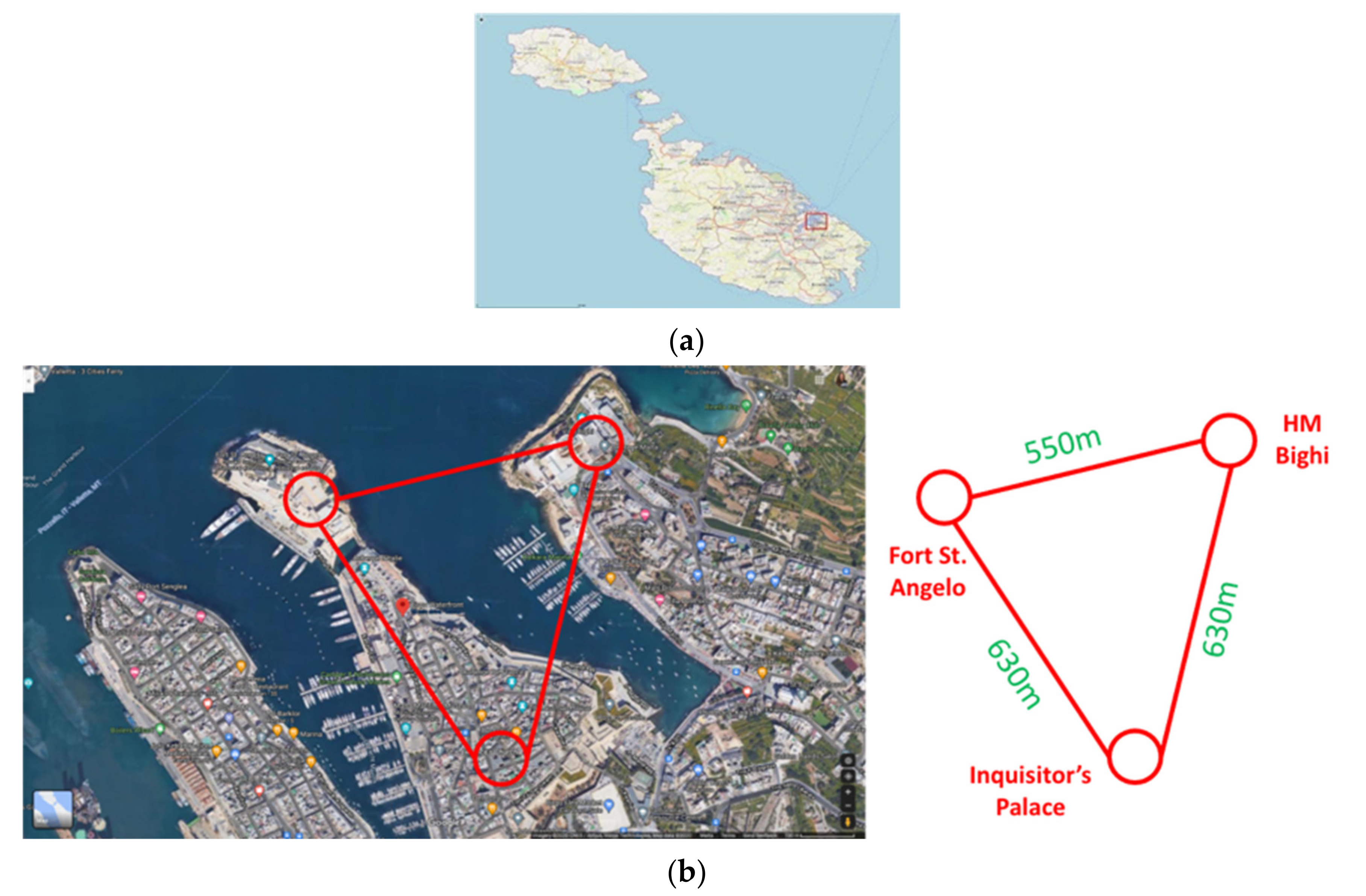
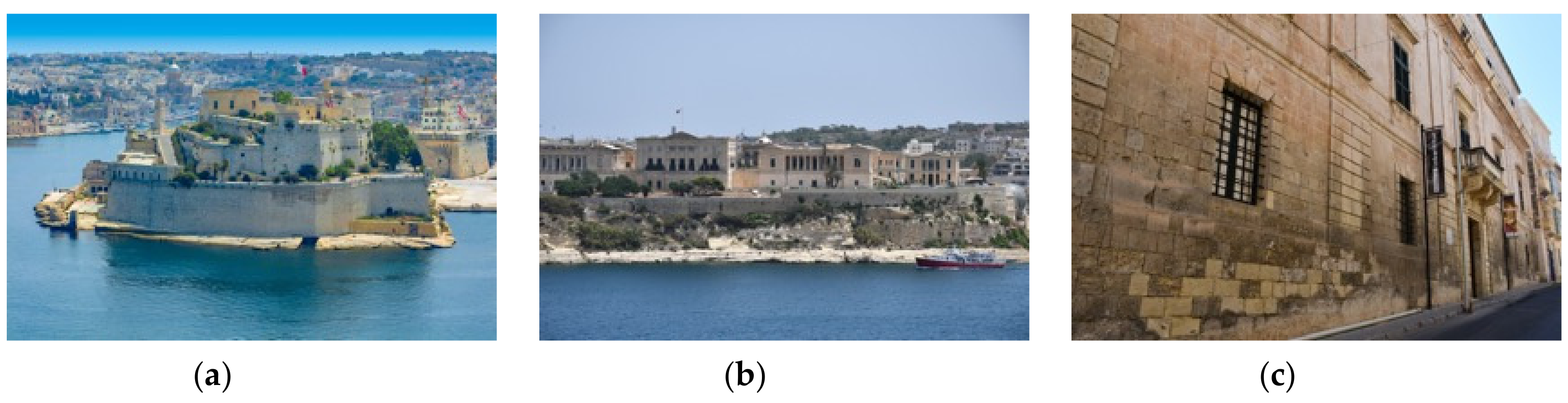
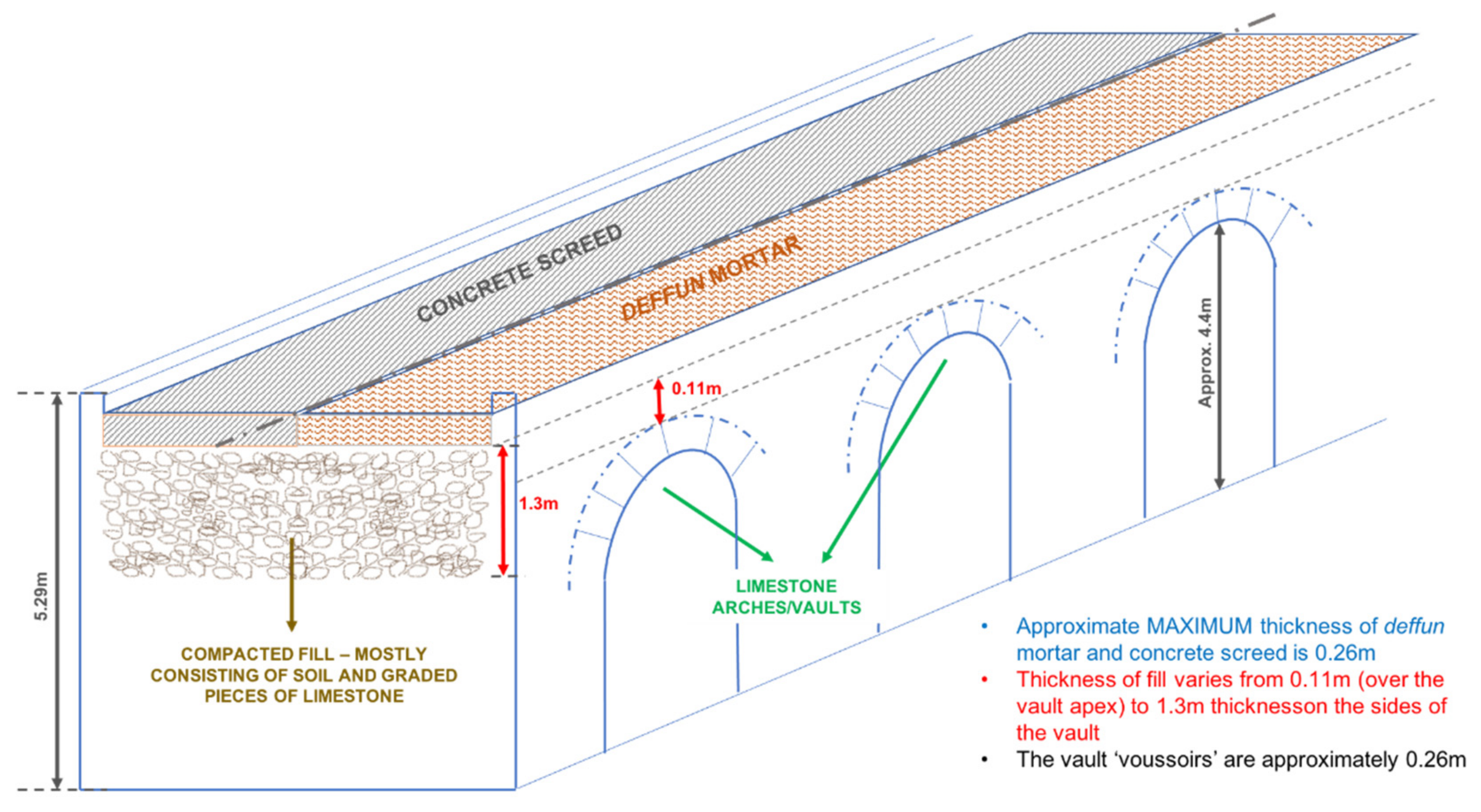
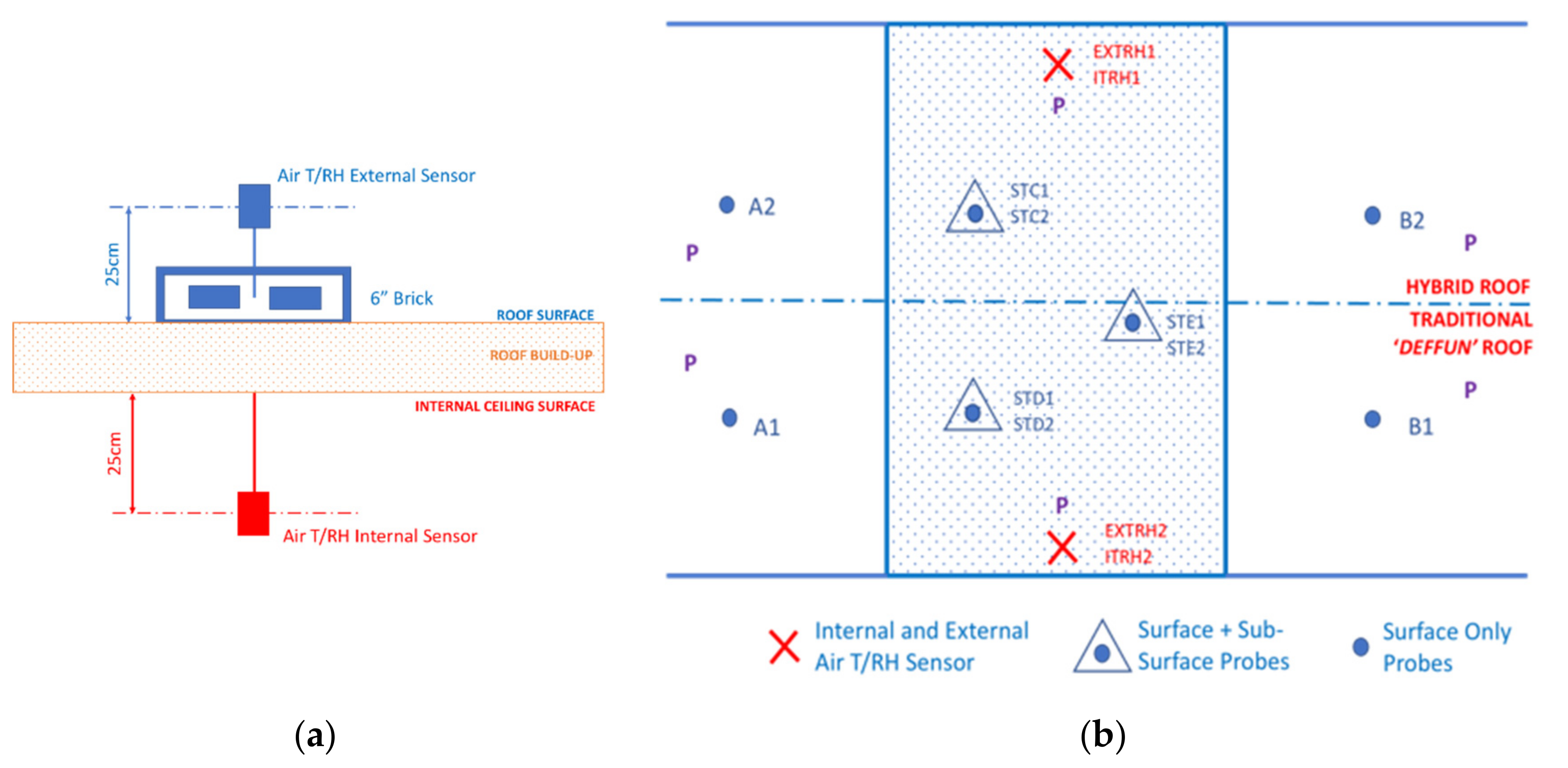
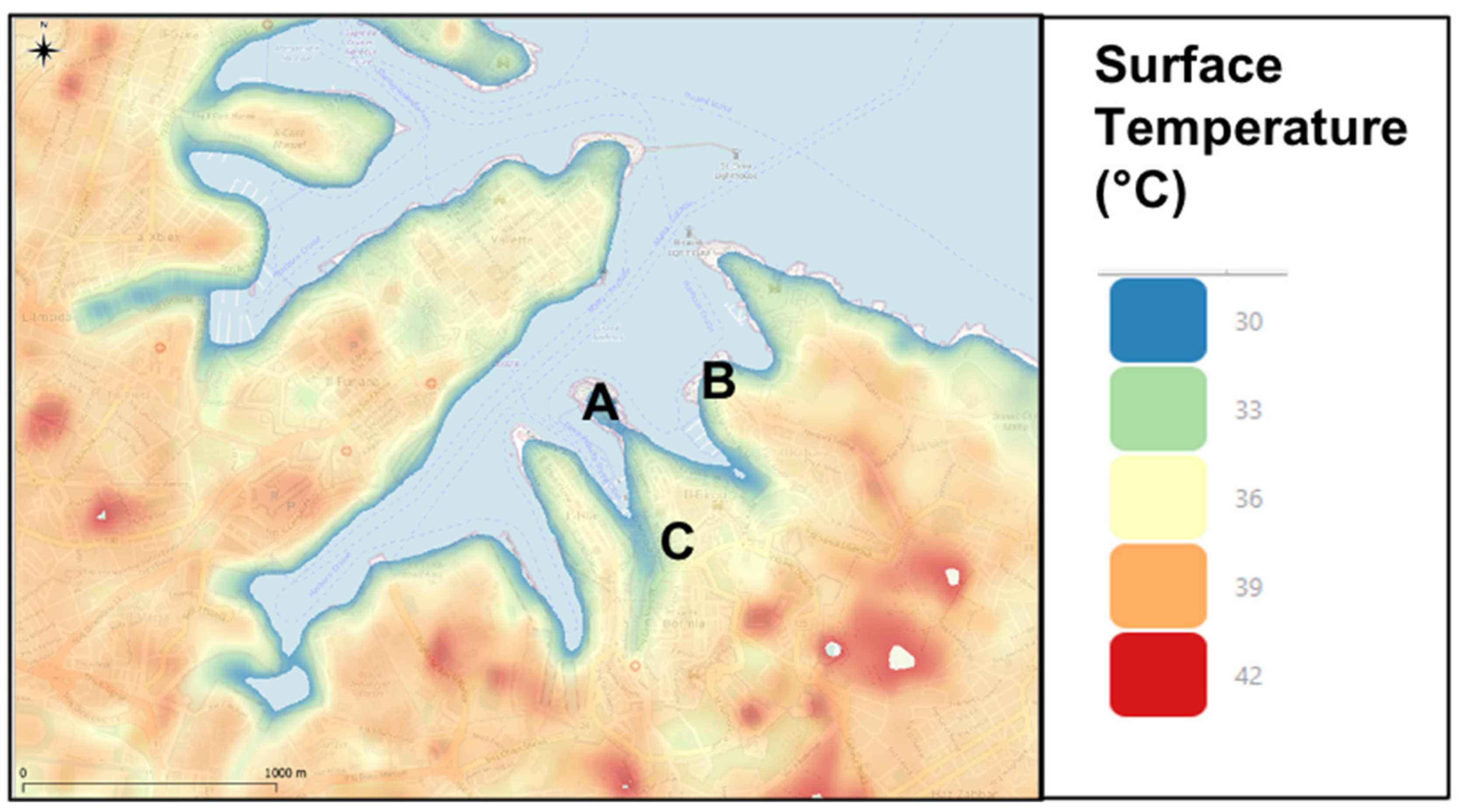
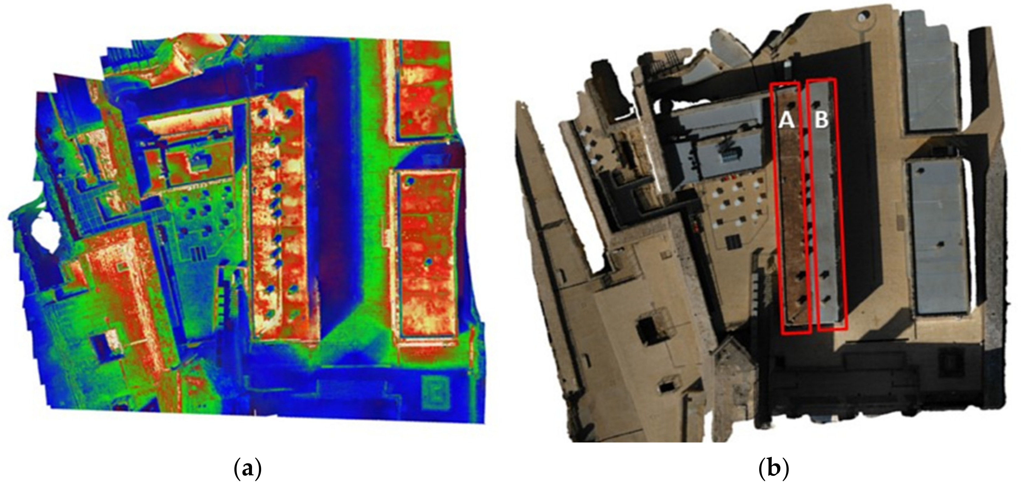
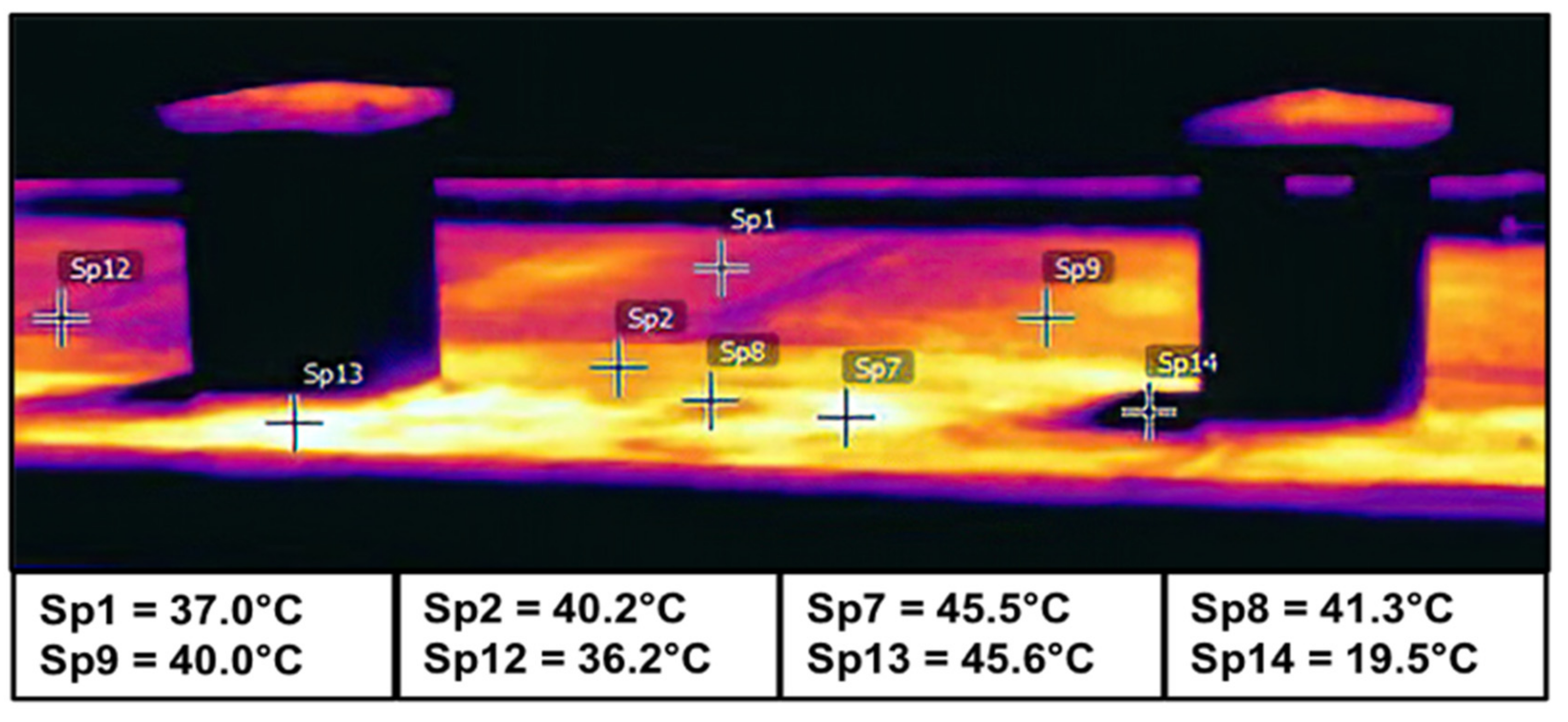
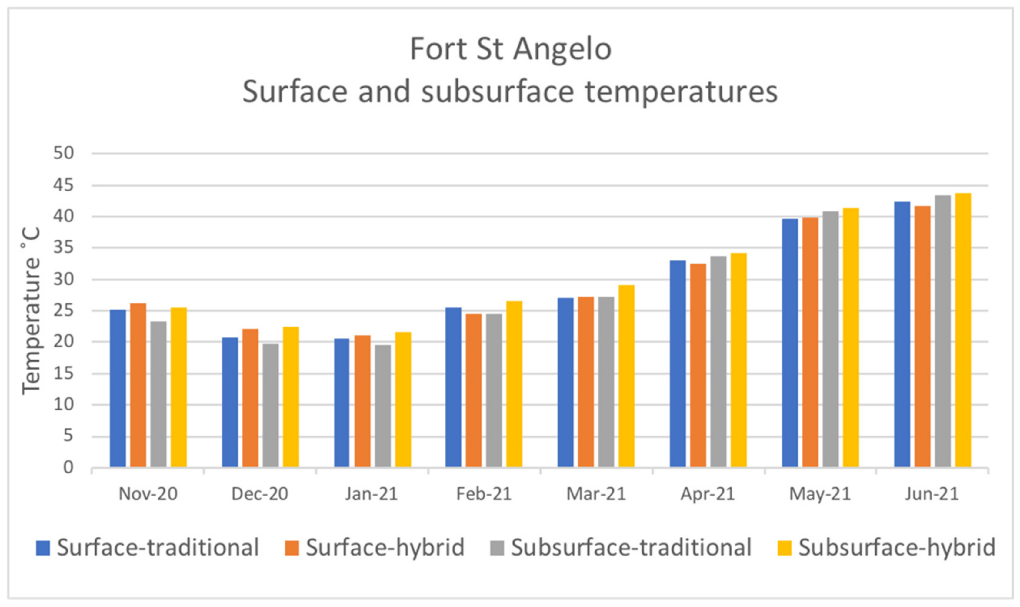
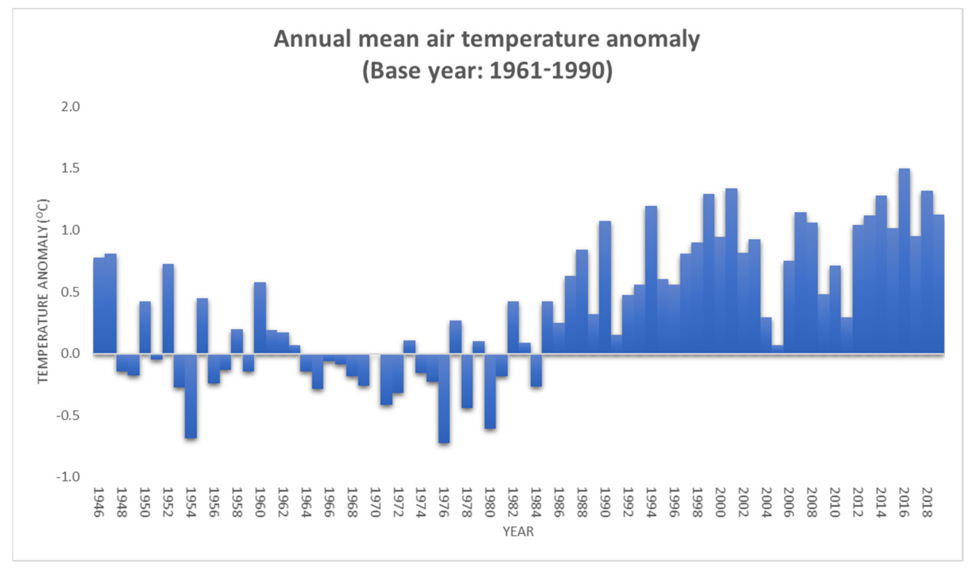
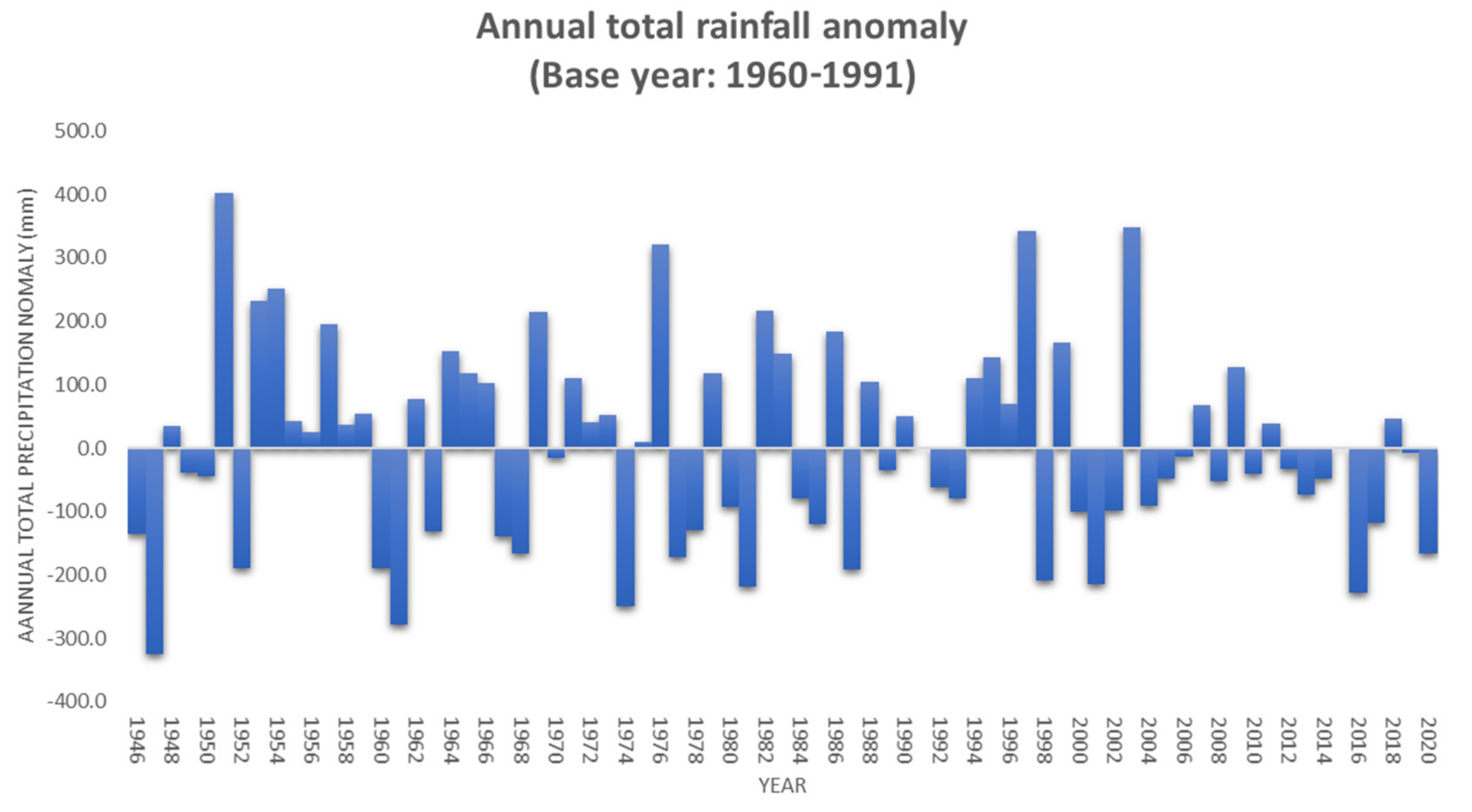
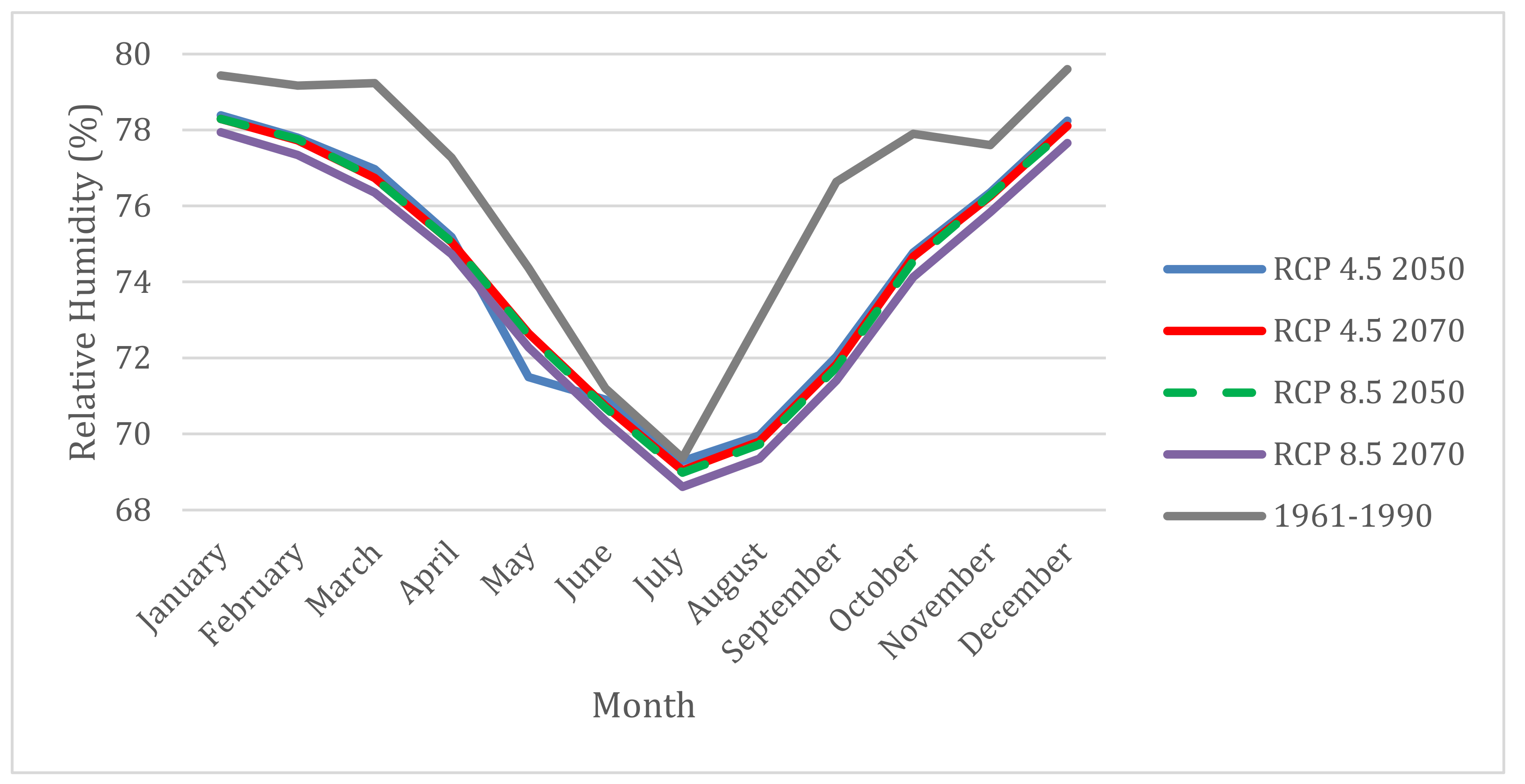


