Article

Integrating Archaeological Data in Multidisciplinary Environmental Studies—Methodological Notes from High-Resolution Mapping of Ancient Features in Southern Israel

by
Moti Mordechai Haiman
Israel Antiquities Authority (Emeritus), P.O. Box 586, Jerusalem 9100402, Israel
Submission received: 21 March 2022 / Revised: 28 May 2022 / Accepted: 29 May 2022 / Published: 31 May 2022
(This article belongs to the Collection Feature Papers)

Abstract

:
The article presents two aspects of a project of high-resolution mapping of archaeological features in the southern region of Israel, which was conducted intermittently between 2003 and 2016. One aspect is archaeological, with emphasis on the dense features underlying the area on the periphery of ancient settlements; the second aspect is the objective of integrating the data in multidisciplinary environmental studies. The main conclusion derived from the mapping project is that the existing data in the databases and publications, despite their richness, will not suffice and that there is a need to return to the field and supplement the features in accordance with the aims of the study. Sorting the collected features is a no less complex challenge, as is the relationship with the settlements in question. This challenge calls for expertise gained from cumulative experience gained in fieldwork, for the simple reason that the features date from different periods, and the potential correlation of certain features with a specific settlement is the test. This kind of upgrading with regard to the archaeological aspect in multidisciplinary environmental studies is critical because, in our view, the archaeological data lag behind the technological development of accompanying research, including research that has employed remote sensing as well as a variety of laboratory tests. It has been found that quite a few of these advanced studies use terms such as “site”, which in many cases is no more than a point indicating the general location of feature distribution. The same applies to the use of dating as a preferred goal before investing the necessary effort in sorting the features. If this effort is not invested first, there is no way of conclusively determining what is being dated and how dating a specific object contributes to understanding the settlement distribution in a region.

1. Introduction: What Is an Archaeological Site?

The rich database of the Israel Antiquities Authority, which is also available online at the Israel Antiquities Survey Website (http://survey.antiquities.org.il/#/Search, accessed on 20 March 2022), was the basis for the current mapping project (Figure 1).
Hence, it is necessary to briefly mention the development of the approach to documenting archaeological features. In this case, we prefer to present the topic via the history of archaeological research in the Negev, which is part of the southern Levant deserts and is characterized by excellent preservation of the archaeological remains that densely cover the area. The fact stands out that early modern research in the 19th century generally focused on the mass of features, before emphasis was placed on ceramics and chronology. As a result, the physical components of the site, which was usually marked as a centralized point, were neglected. The following are three examples of the approach to documenting ancient remains:
The survey conducted by E. H. Palmer in the Sinai, Negev, and southern Jordan deserts in the second half of the 19th century paid particular attention to specific features, e.g., animal traps, rock drawings, and stone piles along cliffs, which were identified as part of ritual installations, agricultural systems, and settlements of all sizes. Palmer’s survey lacks the aspect of precise chronology based on ceramics, which did not exist at the time, but it did mention the location of many sites on detailed maps that were sketched during the survey [1] (pp. 223, 307, 335, 257–260).
N. Glueck conducted surveys in the Negev from 1952 to 1963, in which he documented approximately 500 sites. His research was characterized by years of investment in fieldwork in a given area, as well as by intensive attention to the chronological aspect of the ceramic finds in the context of historical sources [2]. Glueck’s survey of the Negev represents a revolution with regard to the use of the chronological aspect of ceramics. However, the fact was that this new tool neglected components of the sites that were scattered in the area. For example, the fact that the survey presented most of the sites as multiperiod derives from Glueck’s preference to list the features in a large area as one site, which was marked as a centralized point without trying to separate different settlements. This issue can be clarified through one example, namely Site 423 in Glueck’s survey [3], which was described as a ruin from the Iron Age, the Nabatean, and the Byzantine periods. The same site was listed in the Survey of Israel as five separate sites [4]: 219, 220, 224, 225, and 227. It should also be mentioned that the Survey of Israel, as will be shown below, does not represent a final stage in the level of resolution used to document the archaeological features. From our perspective, as mentioned and as will be shown later, emphasis on chronology in itself serves no purpose before the complex amalgam of remains is sorted and the object that one seeks to date is defined.
The Archaeological Survey of Israel began in 1964 and, unlike the two above-mentioned surveys, has aimed to document archaeological sites for the purpose of giving statutory validity under the Antiquities Law and preserving those sites. It is essential to mention that almost all of the researchers involved in the Survey of Israel have also analyzed the finds of their surveys in dissertations and studies. The direct result of this was a drastic increase in the number of features that were listed; however, the location of the remains was marked as a square surrounding the area that the surveyor believed represented the feature distribution, but was much less representative of the features themselves.
This reality was the point of departure for the mapping project presented here, which aimed to return to the variety of sites and map all of the remains as a basis for the continuation of multidisciplinary environmental research.

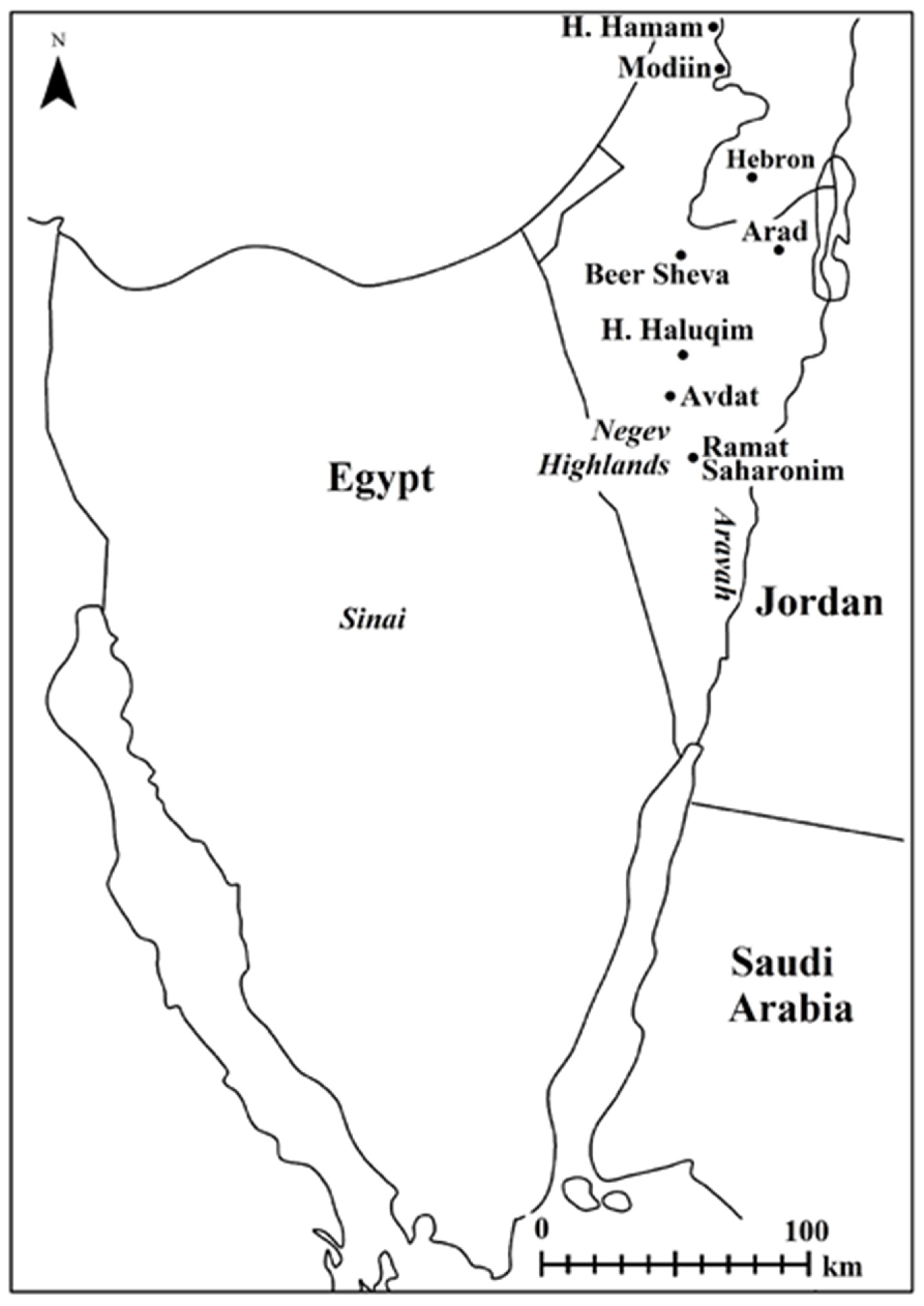
2. The Mapping Project

2.1. Background

The project began in 2003 and focused initially on mapping, by means of a field-walking survey, the complex runoff agricultural systems in the Negev Highlands after we found that all of the components of these systems, some of which have been identified as being adapted to the desert, are also commonly found in the sedentary land to the north: terraced wadis irrigated by slope runoff, industrial wine presses, square field towers, and above all, a large number of monasteries and churches that were at the forefront of this agricultural system. Significantly, the existence of desert agricultural systems in the Beer Sheva Valley, located between “the desert and the sown”, and their similarity to those in the Negev Highlands have been known since the 1960s [5], but they only received renewed attention in the 1990s.
The fieldwork for the project was based on the location of relevant sites in various publications and included detailed mapping, as noted, by a field-walking survey, of all of the visible remains such as dwelling structures, installations, and terraced wadis. The mapping was conducted with a GPS, which enabled us not only to mark the precise location of the remains but also to sketch them. The data were loaded into a geographic information system as a basis for continuing multidisciplinary environmental research including geomorphology and hydrology [6,7,8,9,10,11,12].
Methodologically speaking, as will be clarified below, there is no substitute for a field-walking survey, which is the only way to identify the remains and assess their nature.
The studies that served as a model for the fieldwork in the mapping project dealt with complex runoff agriculture on the periphery of Avdat in the Negev, initiated in the 1950s by Even Ari et al., and can be presented as three links that have not yet been integrated:
The first link: In the initial years of the research by Even Ari et al., the feature distribution was documented in high resolution on the periphery of terraced wadis, and the attempt to sort them by periods is evident in the early reports, which were mainly written by Aharoni, the archaeologist of the delegation [13]. These reports, as mentioned, served as a model for the present mapping project.
The second link: In the final publication of the research [14], the total disregard for the abundance of archeological information about the structures and installations on the periphery of the terraced wadis is noteworthy. Such disregard is disproportional to the considerable progress made in articulating the function of sophisticated runoff and flash-flood wadis. The disregard extended to simple terraces on wadi banks that were consistently found on the periphery of sites from almost all of the periods of settlement in the Negev. The lack of attention to this simple but prevalent group left sophisticated runoff and flood agriculture as the only type of agriculture that has been studied. We argue that in light of years of surveys and studies that have been published extensively in the past, the establishment of the sophisticated runoff systems was an imperial Byzantine project that continued into the Umayyad period in the 6th–8th centuries AD, which could have afforded a project on this scale.
The third link: At the end of the 1970s, Nevo conducted detailed documentation of the agricultural installations and farmhouses on the periphery of Avdat, which also included excavations [15]. One of Nevo’s achievements was his ability to present differences between Byzantine period farmhouses (the square field towers, 6th century CE) and those from the Umayyad period (7th–8th centuries CE). The study did not include a profound discussion of the terraced wadis next to the farmhouses and many installations on their slopes, some of which were mentioned briefly by Even-Ari et al. 20 years earlier.
The preference here for the use of the term “mapping” reflects the approach that this was not a new survey, but aimed to supplement documentation of the features related to settlements such as Avdat and to the components of those settlements, and did not aim to present the chronological aspect. During the course of mapping, it was found that the experience gained with the definition of a site, whose components are densely distributed and mixed with those of other periods, mainly based on the correlation of their features, is more effective than relying on calendar dates. This is the case even when such definition involves advanced dating tools, e.g., C14 and OSL.
With regard to exclusive reliance on calendar dating of the soil in the terraced wadis without any connection to settlements, it does not matter whether such dating is based on OSL or C14 tests. In any case, the date stands on its own without connection to the surroundings. For example, this would explain the Hellenistic-period date that led to the assumption that sophisticated runoff agriculture began as early as that period [16]. The Hellenistic period reflects sparse settlement in the Negev Highlands, which was disproportionate to the tremendous number of terraced wadis. At most, apparently a temporary Hellenistic nomadic site may have been on the periphery of a natural wadi from which the soil was raked to a wadi channel, while the terracing of the wadi took place during the Byzantine and Early Muslim periods. Evidence of the latter was also found in the tests. There is no disregarding the aspect of standard archaeology; if there had been an attempt to date the soil accumulated in the wadi channel on the basis of ceramics, the date would have been rejected immediately on the grounds that the soil accumulated in the terraces was fill and not a sealed stratigraphic layer.
Several points relate to the attempt to examine and integrate the findings of the current mapping project into several multidisciplinary studies:
One study dealt with the attempt to identify the terraced wadis on the southern margins of the sedentary land ca. 30 km northeast of the Beer Sheva Valley as a runoff system. The results confirmed the hypothesis that it was in fact a runoff system. The results also showed that the system increased the amount of water reaching the soil of the terraced wadis by 40% in comparison with the surrounding area [6]. This means that in the climate of the region of the study, where drought is prevalent, the crops in the terraced wadis were successful almost every year, whereas in the agricultural areas outside of the terraced wadis they were much less so.
Another study examined runoff agriculture in the loess regions of the Beer Sheva Valley, where previous studies concluded that runoff agriculture could not have existed [17]. However, the previous study did not consider the remains of ancient runoff agriculture that were scattered throughout the region and that are known from the research. A multidisciplinary reexamination of the agricultural systems in the area revealed that this agriculture is indeed prevalent throughout the region, but only in terraced wadis or on the periphery in natural wadi channels and not in the loess plains themselves [10].
Another study examined the remains of the agricultural systems in the arid Arava and dealt with the implications of detailed mapping and the need to classify the different types of terraces rather than suffice with the general term “terrace”. A basis was also found for the different types of simple terraces that reflect a range of approaches to taking advantage of the difficult environmental conditions at specific sites [12].

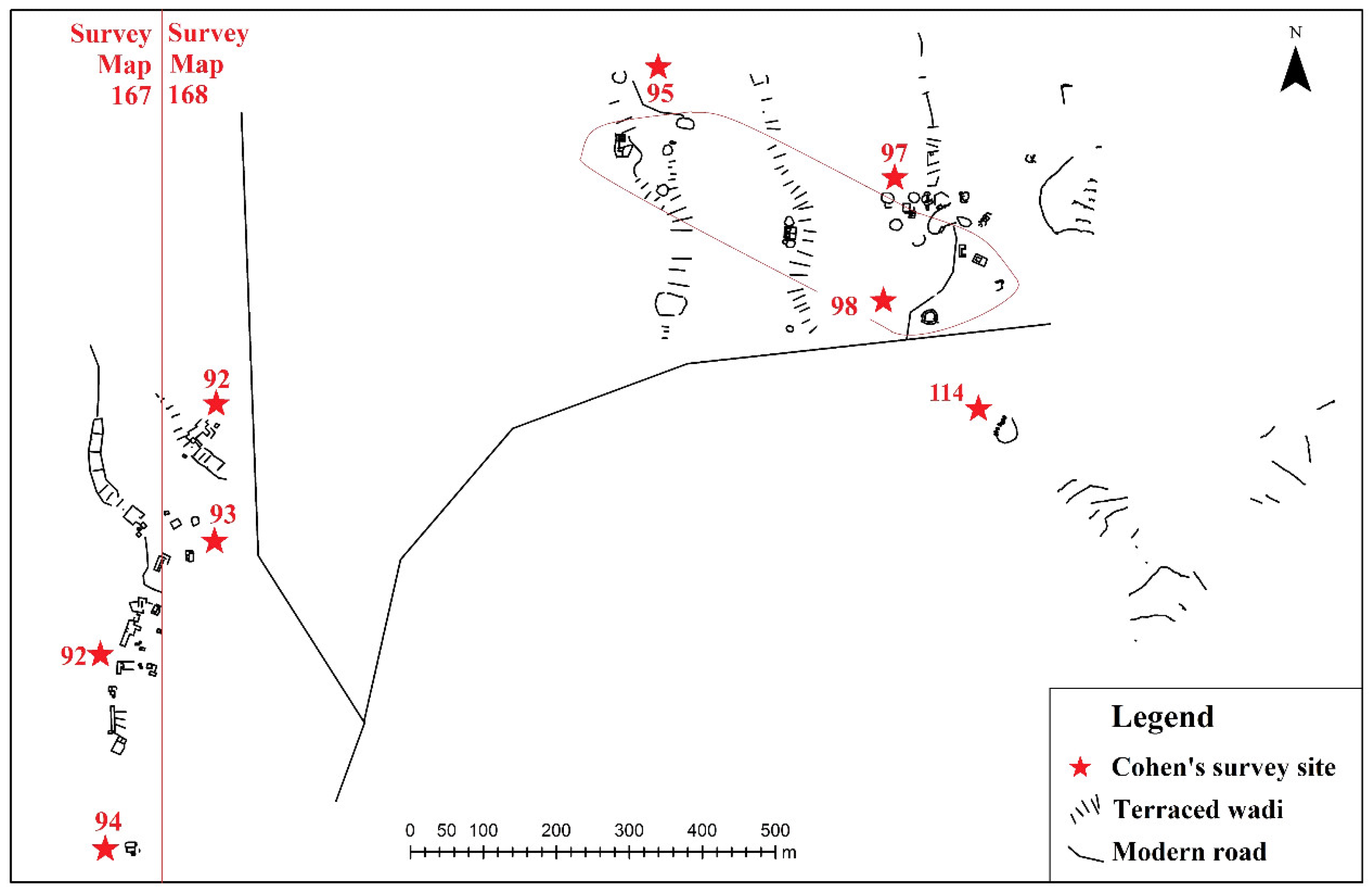
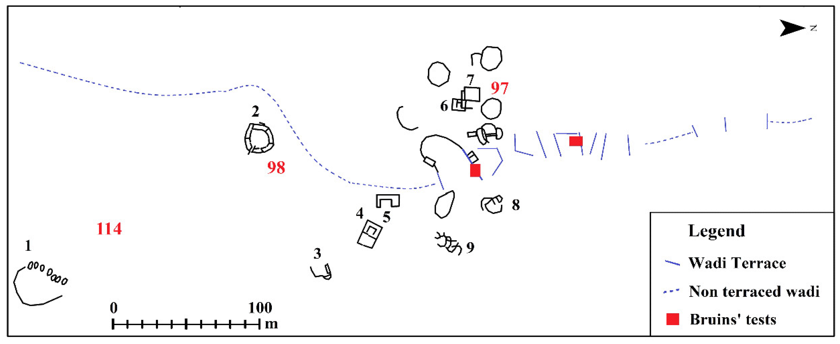
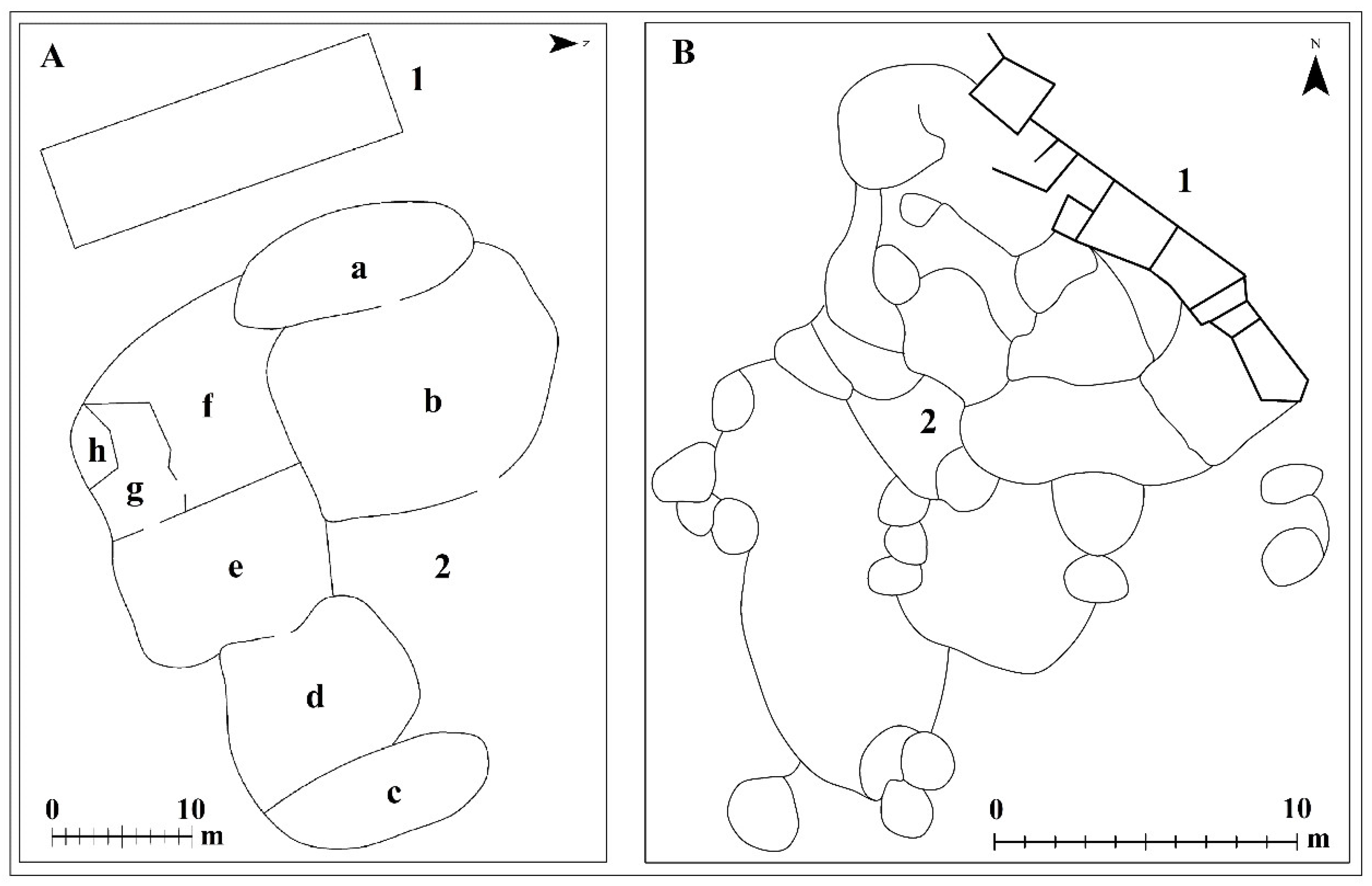
2.2. Three Fieldwork Projects

The following is a detailed discussion of three studies in the framework of the mapping projects in which the relationship between data from the mapping project and other multidisciplinary studies is addressed. The discussion also addresses remote sensing and other innovative approaches to dating that provide evidence of the potential inherent in this direction of environmental research.

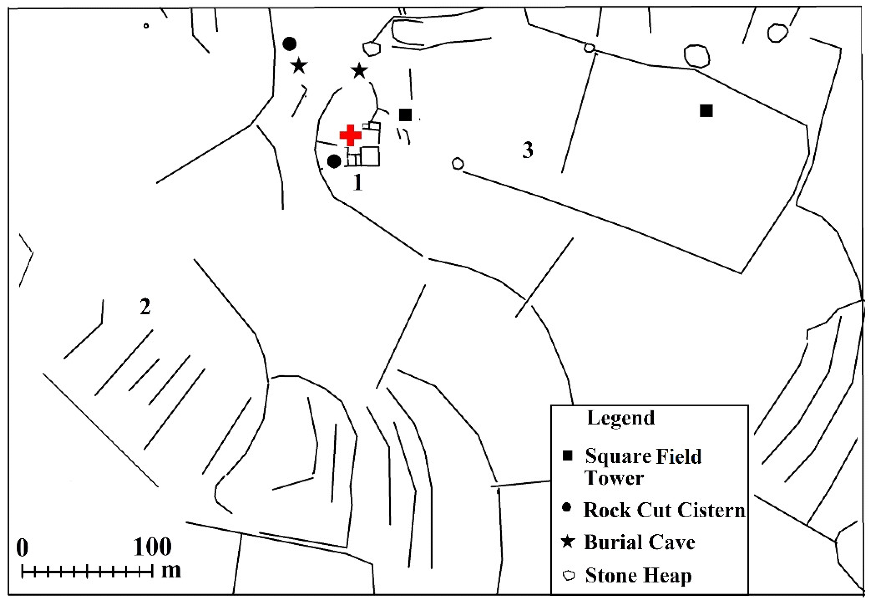
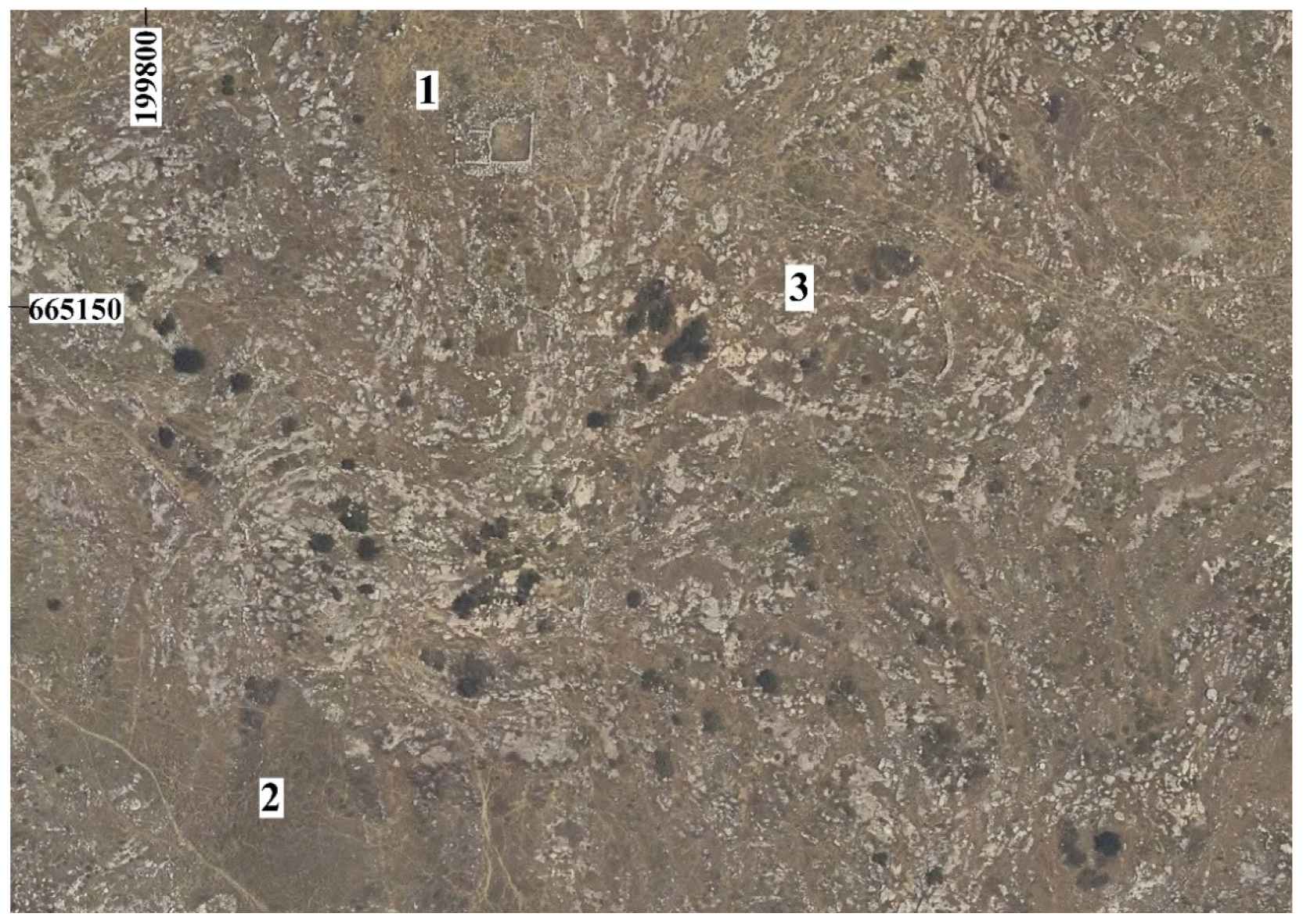
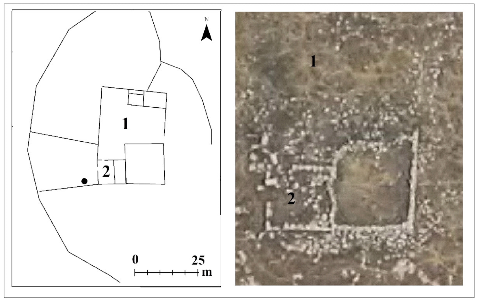
2.2.1. Horvat Haluqim

The mapping project in this area focused on the terraced wadis and sites 92–94 on the left side of Figure 1 [7,8], and it also included the area of Horvat Haluqim. The numerous studies focused on the Horvat Haluqim site’s components in themselves represent almost all of the points in this article. These studies included archaeological surveys and excavations by Cohen [18] (sites 95, 97, 98, 114), [19] (pp. 41–45), [20], the long-term research by Bruins et al. [21,22,23,24], and the abiding interest that his conclusions aroused among the scholars specializing in remote sensing and among multidisciplinary scholars today [25] (pp. 63–66). Figure 2 and Figure 3 below are more representative of the methodological challenge related to maximizing archaeological data than they are of finding alternative conclusions.
The site of Horvat Haluqim as defined by Cohen, the surveyor and the first excavator, relates to Iron Age remains (10th century BCE), including a fortress and about 15 dwelling structures, distributed in an area of about 200 × 600 m, whose integration into a settlement is a matter of interpretation. Cohen attributed to this site the channels of terraced wadis between the scattered structures.
In methodological terms, Cohen emphasized the main period of the features included in Site 98 from the Iron Age and only marginally mentioned structures from other periods, such as Site 97 from the Roman period and Site 95 from the Byzantine period.
Figure 2 presents the problem of numbering the complex array of remains (even before attempting to upgrade the resolution of the remains, as will be described later). The decision that the elements marked in Site 98 belong to Horvat Haluqim was made by the surveyor, but it is not relevant to the statutory declaration that the entire area is an antiquities site, which, as mentioned, was the purpose of the survey. Nonetheless, there is the question of whether all the features in the vicinity of Site 98 were documented in order to provide a basis for continuing multidisciplinary research of the kind presented in this article. Regarding our preferred interpretation, it appears that the terraced wadi channels at Horvat Haluqim belong to the Sede Boqer site, which was excavated and studied about 1 km to the west [26] (Map 167 sites 92, 94), [27], based on the consistent correlation of these types of terraced wadis and Early Muslim farmhouses. However, it is important to note that neither our preferred interpretation nor any other interpretation rules out the necessity of mapping all the remains as a basis for any continued research.
Figure 3 presents the wadi excavated by Bruins and its margins (the numbers in red are from Cohen’s survey, and the numbers in black were allocated for the present article): 1: a recent Bedouin cemetery; 2: the Horvat Haluqim Fortress; 3, 4, 5: Iron Age structures; 6: a square Iron Age tower; 7: a Roman tower (3rd century CE); 8, 9: structures from the Early Bronze Age (3rd millennium BCE), discovered in the mapping project.
Following the work with Bruins [24], a preliminary test of the components of the Horvat Haluqim site, as Cohen had defined it, included a fortress, dwelling structures, and terraced wadis [18]. The preliminary test sufficed to confirm the assumption that the peripheries of terraced wadis had not been given sufficient attention. Among other things, two Early Bronze Age structures, mentioned in Figure 3, were identified, which were dated from periods that were also found in Bruins’ tests of the soil in the terraced wadi. As mentioned, to our understanding the soil in the wadi dates back to the periods of the sites on its periphery from where the soil was taken for building the terraces in the Umayyad period [9] (pp. 191–195).
At Horvat Haluqim the argument was repeated that the terraced wadis were contemporaneous with the Iron Age site [22,24]. This was believed to be self-evident, simply in light of their proximity of the sites to one another. Regarding the connection between the features of terraced wadis such as those at Horvat Haluqim and Iron Age sites, examination of the distribution of the Iron Age features over a large area reveals finds indicative of agricultural activity such as threshing floors, granaries, and sickle blades, which have also been found in areas without terraced wadis [28] (sites 31, 35, 42, 104). It can therefore be concluded that during the Iron Age they took advantage of natural unterraced wadi banks and that the systematic terracing of wadis as part of desert runoff agriculture can be attributed to the 6th–8th centuries AD.
Regarding the complex features of the remains at Horvat Haluqim, it is noteworthy that in excavations conducted on the periphery of terraced wadis [22], one structure was dated to the 9th century BCE on the basis of a C14 test, in contrast to the rest of the site which was dated to the 10th century BCE. A similar date was found at Atar Haro’ah, an Iron Age site about 5 km to the east [29]. It is therefore possible that some of the structures at Horvat Haluqim in fact reveal the periphery of the Atar Haro’ah site. In addition, as mentioned, Structure 6 in Figure 3 was identified as a type of square tower that was prevalent during the Iron Age. Its presence side by side with the oval fortress, together with the C14 dates obtained for the residential structure, lead to the conclusion that not all of the components of Horvat Haluqim dated to the Iron Age IIA are contemporaneous. This possibility justifies the methodological approach adopted here, which not only challenges the term “site” in the context of high-resolution archaeology, but also challenges the term “period” as a general chronological term because it is possible that in this kind of ostensibly defined setting not all of the components were contemporaneous.
Regarding the dates of the layers of fill in the terraced wadi, there are those who believe that the soil originated from alluvium [25] (pp. 63–66). However the dates of the terraces have no connection to the issue of Iron Age agriculture in Horvat Haluqim or in any other site, especially when it concerns generalized statements based on tests at sporadic sites [30]. In surveys and excavations of dozens of Iron Age sites in the Negev Highlands, evidence was found of threshing floors, granaries, and sickle blades [31]. The same is true of excavations such as the one at Tel Qadesh Barnea [32] in all areas of the site, and there is no need to add further details. In this context, the granary excavated at Horvat Haluqim is noteworthy in and of itself [23] (p. 1237). In light of this evidence, the proposal that agriculture did not exist during the Iron Age in the Negev is a narrowly based generalization, and it provides additional support for the premise that every study needs to be based on all of the components of the sites in a given area rather than on sporadic samples from floors of a fortress and a structure.
Regarding the broad range of dates of the soil that accumulated in the terraced wadi, according to our methodology, the dates do not derive from the history of the wadi, but from the remains of sites from different periods on both sides of the wadi that were swept down when the terraces were built. Indirect evidence of this can be found in Ore’s thesis, which was written as part of Bruins’ research and included a detailed hydrological analysis which found that the amount of soil in the terraces was much greater than the potential for natural alluvium from the slopes of both sides of the wadi [33] (p. 61). As we understand it, all of the periods presented in Bruins’ sections are also presented at sites on a nearby slope. This means that the terraces were filled with material that was swept away from the slopes by those who built the terraced wadis, and in my opinion, this occurred in this specific wadi in the Early Muslim period. It appears that the broad range of dates does not derive from a weakness or advantage of C14 or OSL tests. Rather, it derives from the complex amalgam of ruins on the periphery of the wadi near Horvat Haluqim. In a study that took place in a totally different environment, located in the arid Arava desert about 100 km to the south, a much more limited range of dates was obtained [12]. It may be assumed that the limited range of dates derives primarily from the paucity of ruins in that area.
Another site on the banks of the wadi next to Horvat Haluqim that might provide insights into the wide range of dates is Site 114 in Figure 3 of Cohen’s survey. The survey documented a water cistern cast out of cement in a tin board that can be locked. This is further evidence of how ancient water cisterns have been used by the Bedouins since the end of the 19th century. In the present mapping project, a Bedouin cemetery documented near the cistern was also mentioned in a study on the topic [34]. This fact provides evidence of a Bedouin presence in the area, and the remains of Bedouin tents can be identified in a detailed survey. The evidence also indicates that the Bedouins cultivated the ancient terraced wadis, as has been found in all of the studies dealing with the Bedouins in the Negev Highlands and beyond [35] (p. 25), [36] (pp. 181–188, 192–202). Their activity also contributed to OSL dating that fits the last century [12] (pp. 1051–1052).

2.2.2. Sheep in an Arid Environment

In an ethno-archaeological study [37], several recent Bedouin shepherds’ camps were mapped in the Modi’in area, located in the sedentary land about 100 km north of the Negev. These camps attracted attention because their plans are similar to ancient enclosed structures, consist of dwelling rooms and courtyards documented in archaeological surveys in the deserts of the southern Levant, and were identified as a sheep/goat pen already in the 19th century [1] (pp. 78–82, 134–139, 291–299).
A study of the possibility of raising sheep in the deserts of the southern Levant will be published elsewhere. The intention here is to present one settlement period alone, the Early Bronze Age, to illustrate the importance of mapping site components from the methodological aspect, given that the results of such mapping are those that led to the theory that these were sheep enclosures.
It emerges that the Bedouins who built these camps lived in the desert area of Arad in the northeastern Negev, where they drove their herds of sheep to seasonal green grazing land for several months every year. Thus, the enclosed Bedouin structure represents a sheep pen. It is essentially different from a goat pen, which usually includes only one courtyard and sometimes an addition of up to three secondary units, as has also been documented in a different environment [38].
Figure 4A represents a Bedouin shepherds’ camp that held about 300 sheep. The camp included: (1) a residential tent measuring 8 × 24 m occupied by representatives of one family from Arad; (2) a pen divided into eight subunits: (a) a courtyard measuring about 70 sq. m, with about 30 lambs of the age of four–five months that graze; (b) a courtyard measuring about 200 sq. m, with about 150 ewes that had not yet given birth; (c) a courtyard measuring about 70 sq. m, with 16 adult sheep that do not graze; (d) a courtyard measuring about 100 sq. m, with about 40 lambs below the age of three months that do not yet graze; (e) a courtyard measuring about 120 sq. m with about 70 ewes, the mothers of the lambs that were separated into courtyards a and d, which was used as an area for nursing and feeding the lambs; (f) a courtyard measuring about 100 sq. m for the 70 ewes in courtyard e to sleep; (g) a milking area; (h) a place for shepherds to sleep.
Figure 4B represents an enclosed structure from the Early Bronze Age [31], about 4 km northeast of Ein Qadis, which includes: (1) a row of dwelling rooms of the “Arad” type (see explanation below). The general measurement of the rooms is 3 × 15 m and their walls are built of large stones about 0.80 m long; (2) a pen measuring about 350 sq. m, which is divided into about 30 subunits measuring 4–70 sq. m. The plan of the site may reflect a camp of several families, as evidenced in the row of dwelling rooms. The walls of the pen were built of stones of various sizes, and the difference between the quality of construction in the pen and the dwelling rooms is striking.
There is no doubt that it is more appropriate to raise goats than sheep in a desert environment. This is true of contemporary Bedouin society as well as most of the ancient periods based on the plan of the pens, as documented in the surveys of the Negev, although sheep husbandry is not impossible. Examination of the possibility of raising sheep in the desert must take into account two limitations [35] (pp. 9–12), [36,39]:
  • Watering: Sheep need to drink three times a day, whereas goats can manage with two times a day, which means that a herd of goats can stay away from a water source all day, which makes more efficient use of meager herbage in arid areas.
  • Green grazing: Without seasonal green pasture sheep cannot breed, and as a result they do not provide dairy products. This problem does not exist for goats.
In the process of exploring the topic, another point was raised, which clarifies some aspects related to sheep husbandry in the desert.
Encouragement of recent Bedouins in the southwestern Levant to transition from goat husbandry, which is more appropriate for arid areas, to sheep husbandry, which is more economically feasible, has been attributed to the Ottoman regime at the end of the 19th century. It was at that time when boundaries were set between the Bedouin tribes, most of which were pushed to the northern Negev from the periphery of the sedentary land in the north [36], [40] (p. 74). In terms of the environmental conditions, the northern Negev has poor water sources and is plagued by drought as well as very poor potential for seasonal green grazing [39] (pp. 12–13). To ease the situation, the British Mandate regime between the 1920s and 1940s developed sources of drinking water and led the Bedouin herds to grazing grounds in the sedentary land in the north [35,41], [42] (pp. 75–76).
The leading of sheep herds to the north, especially from the arid region of Arad, has continued to this very day, as has been found in the area of Modi’in. The bottom line is that in the vicinity of Arad, sheep cannot be raised to a significant extent due to the environmental limitations. The transition to sheep husbandry for economic purposes requires green grazing areas every year, which can be found in the northern regions. It is important to add to the economic aspect the aspect of contact with an external factor that will consume the sheep and their products. Without such contact, there is no point in large-scale sheep husbandry.
Examination of the possibility of sheep husbandry south of the Beersheba Valley reveals a certain absurdity in terms of the environment: For example, in the Negev Highlands, located about 100 km south of the Beersheba Valley, where the amount of rainfall is about half as much as in the Beersheba Valley, there is an abundance of seasonal green grazing grounds in the dense network of ancient terraced wadis that functions to this very day [43] as well as non-terraced wadis, owing to the efficient utilization of runoff rainwater.
Regarding the possibility that the enclosed structure reflects sheep husbandry, this type of structure has been identified during most of the ancient periods of settlement in the Negev—but in negligible percentages compared with the simpler pens that have been identified as goat pens. A particularly clear exception is the group of Early Bronze Age settlements that can be found between Arad and the southern Sinai, where the enclosed structures are dominant and number in the hundreds. Notably, there is a lack of consensus regarding the definition of the Early Bronze Age (3500–2200 BCE) cultures scattered throughout the Negev and Sinai deserts, as well as regarding the dates of those cultures—but we will not pursue that issue here [44]. One of the clear testimonies to the relationship between this group of sites and Arad is a type of rectangular dwelling structure dominant at Arad, which is also common in the Negev Highlands and in Sinai [45] (pp. 439–444). Irrespective of the possibility that the large-scale relationship between Arad and the southern Sinai was based only on trade in sheep, as reflected in the dominance of enclosed structures, two exceptional finds attest to a spatial relationship between the desert population and a permanent external factor—in this case the city of Arad:
  • The dominant ceramic vessel at the above-mentioned sites, a jar known as the “Arad hole-mouth jar”, constitutes up to 90% of all the ceramic vessels found at sites in the western Negev Highlands; petrographic tests showed that about 40% of the hole-mouth jars in Arad, about 70% of the hole-mouth jars at sites in the southern Sinai, and almost all the jars in the Western Negev Highlands sites were produced in southern Sinai.
  • The dominant flint implement in the sites of this settlement group is the tabular scraper (also known as a fan scrape)—a kind of flint board with sharp margins.
This type of tool is dominant from two points of view: one is its high percentage—20–25% of all flint tools at the above-mentioned sites, compared with 5% of the flint tools from other Early Bronze Age settlement groups in the Negev and Sinai. The other notable evidence is that the tabular scrapers were not produced in the sites where they were found, but at a manufacturing center at Har Keren in the Negev Highlands [46,47], which also reflects an industrial aspect of production and organized distribution over a large space. A study on the topic indicated that the tabular scraper is particularly effective for shearing the thick wool of sheep [48]. This supports the hypothesis that the enclosed structure is a pen for sheep. The possibility of additional uses for this tool [49] does not contradict the possibility that it was used for shearing sheep as well, especially in light of the high percentage of the tabular scrapers out of all the tools in this group of settlements.
The finds of bones in excavations [50] should also be briefly mentioned, including a large number of sheep and goat bones in the excavations of Arad [51]. Notably, Arad is an urban settlement without pens, and it can be assumed that in this kind of settlement, the source of the bones is trade. Because of the limitations of the environmental conditions in the vicinity of Arad, the possibility that the sheep were from the south cannot be ruled out.
Here we will discuss Saidel’s proposal that the enclosed structures of the type described above, which are closely connected with a specific type of cairn fields, are not contemporaneous with the cairns but were attached to cairns from an earlier period [52]. This proposal challenges the methodology adopted in the present article, which focuses on high-resolution documentation of archaeological features. Such resolution enables alternative interpretations of the correlation between elements dispersed in an area. Moreover, it provides an opportunity to show the unbridgeable gap between the high-resolution method and the solely chronological approach, which considers the components of archaeological sites only in general terms and focuses exclusively on dating. An example of this is a section of the cairn field at Nahal Mitnan (Figure 5), which includes eight cairns, four of which are integrated into an Early Bronze Age structure from the Arad–southern Sinai group.
Saidel argues that in another structure of that cairn field, one of the walls passing above a cairn means that the structures were built next to cairns from an earlier period. By way of comparison, Beit-Arieh made an attempt, albeit in the opposite direction, in his excavations of the same type of sites in southern Sinai. Beit-Arieh presented every plausible explanation to prove that the cairns were added to the attached buildings at a later stage [45] (pp. 21–22). At Nahal Mitnan, it was also found that some of the walls of structures were adjacent to cairns, whereas others were built above them. It appears that this is not a case of stratigraphy but one of technical inconsistency in integrating the cairns into a dwelling structure. However, this topic requires further examination. The methodological argument that the cairn fields are connected with the settlement of Nahal Mitnan was based, as mentioned, on the consistent relationship between the distribution of the cairn fields and the distribution of the settlement from the Arad–southern Sinai group of the kind at Nahal Mitnan over extensive areas. Such distribution has not been identified in any other settlement groups from the Early Bronze Age, such as in northern Sinai and the southern Arava. Regarding the comparison with the Ramat Saharonim site, every detail of the elements that comprise the cairn field at Nahal Mitnan is similar to the sites excavated by Beit Arieh in the southern Sinai, but completely different from those excavated at Ramat Saharonim. The cairns at Ramat Saharonim are of Nawamis tomb type that is also prevalent in the southern Sinai. These tombs have been dated to the 5th-early 4th millennia BCE and mainly contain completely different cairns that are over 1.5 m high [53], [54] (Site 13, pp. 21–24). In addition, there is a striking similarity between the wall temples at Ramat Saharonim and those at the Nawamis fields in southern Sinai, which are completely different from those at Nahal Mitnan that contain only one wall. Of the cairns at Ramat Saharonim that have been published, only a Namus typical of those in southern Sinai and a rock pile with two burial layers were excavated [55]. An OSL test found that the rock pile and the practice of burial in Namus tombs date to the late Neolithic period, whereas the later burial practices date to the Hellenistic period [56,57]. The early date is consistent with other OSL tests conducted at the site [56], which revealed that it dates from the 4th-5th millennia BCE. It is not clear whether cairns of the type found at Nahal Mitnan were also found around the site at Ramat Saharonim, but in OSL tests conducted in three cairns found at another cairn field, in Shluhat Qadesh Barnea, which continues the cairn field of Nahal Mitnan to the north, cairns of the same type dating to 2800–2500 BCE were found [58]. These dates correspond with the chronology of the Early Bronze Age II, the framework in which the sites from the Arad and the southern Sinai existed.
The chronological issue of the Early Bronze Age settlement system in the Negev and Sinai continues to arouse interest and constitutes a basis for refreshing old interpretations [59]. This view is indicative of an unbridgeable gap with the methodology that emphasizes the need to upgrade the components of the sites scattered in the area. This upgrade reflects not only the differences between the groups of settlements but also the purely chronological discussion that focuses on the “site” without specifying its components.

2.2.3. In the Area of the Sedentary Land: Horvat Hamam

One of the first tests of the mapping project was, as mentioned, to examine the view that the components of the desert runoff agriculture systems are also prevalent in the sedentary land to the north [7] (pp. 46–47), [60]. Examination of the approach to this issue in other research disciplines [61] shed light on the finds from the mapping project from unanticipated directions and provided additional evidence attesting to the necessity for multidisciplinary research. For example, Yair’s examination of the possibility that climate changes motivated the development of desert runoff agriculture revealed that the walls of the first-order stream terraced wadis were about 1 m thick, which reflects the ability to withstand runoff pressure amounting to about 100 mm of annual rainfall, and this is the exact situation today. The desert runoff systems in the Negev will not function with less than 80 mm of annual rainfall [14] (p. 109), and in an improved climate, terraced walls of that thickness would have eroded. In the mapping project north of the Negev, a prominent finding was that the first-order stream terraced walls of the wadis were sometimes 2 m thick, i.e., double the thickness of those in the Negev. A possible explanation for this is the need to withstand pressure amounting to up to about 300 mm of annual rainfall, as is the situation today, albeit infrequently.
Figure 6, Figure 7 and Figure 8 below relate to the area on the periphery of Horvat Hamam to the south, which represents a small section of a large and densely sown area of settlements and their agricultural peripheries, and provides an opportunity to discuss the gap between the fieldwork of mapping the archaeological features and the option of relying exclusively on aerial photos. The gap between ground mapping as shown in Figure 6 and the orthophpto of Figure 7 of the same area is well reflected. Even the drone photos in the framework of the present project, taken south of the area here only after the field-walking survey, for the purpose of calculating surface runoff and soil accumulation, could not identify all the features that were essential for the purpose of the research (see [10]). In addition, Structure 1 in Figure 6, Figure 7 and Figure 8 represents the issue of identifying the head of the agricultural settlement. The finds indicate that all of the structures of this type that were excavated are monasteries scattered densely in the area. These types of structures were identified as monasteries as early as the 19th century, particularly the structure mentioned here [62] (p. 93), based on its architectonic quality as well as on segments of stone pillars, found in the same place to this day, as well as on scattered floor mosaic stones.
Figure 6 shows the following: (1) A structure identified here as a monastery (see below) measures about 9 × 13 m and consists of several rooms around a central courtyard. Square field towers are scattered close by, as are burial caves and water cisterns. (2) A terraced wadi about 80 m wide and several hundred meters long is shown. (3) On the slopes, stone walls marking agricultural plots can be identified, as well as paths that are about 1 m wide, some of which have been discussed [63] (p. 102).
Figure 7 presents an orthophoto of the area in Figure 6, in order to illustrate the fact that not all of the features in Figure 6 can be identified, such as the square field towers and the installations around Structure 1. However, the figure effectively completes the mapping of the terraced wadis and the agricultural plots on the slopes.
Figure 8 shows the more prominent room (marked 2 in Figure 8) in Structure 1, which was also mentioned in the two previous figures. The room measures 3 × 5 m with scattered mosaic floor tiles and can be identified as a chapel. Its walls are built of carefully hewn stones, and their quality stands out against the other walls in the structure, as can also be noted in the orthophoto. We should add to this, as mentioned, the fragments of stone pillars next to the structure that in the 19th century led to the conclusion that the structure was a monastery.
The argument regarding the definition of this type of structure should also be briefly mentioned: In contrast to those who believe that the structure was a monastery, others have identified it as an estate house. Explanations for these arguments have been raised in several studies and dissertations that have also summarized many previous studies [63] (pp. 254–256), [64,65]. In the most recent study of Structure 1, it was defined as an estate house [63] (pp.104–105), although the researcher cited a quote by Guérin describing that specific structure and identified it as a monastery.
From the perspective of the mapping project, the fact that almost all of the recent arguments have not taken into account the complex array of features around those structures is noteworthy. Documentation of the remains in Figure 6 here, which was partially conducted in the frame of Shadman’s study [63] (pp. 98–106), reflects the exact basis for the methodology here. Irrespective of the nature of the structure, the assemblage of remains around the structure needs to be documented. Among the components of the agricultural assemblage around the structure, there are terraced wadis, cultivated slopes, square field towers, and burial caves similar to those in the other structures of this type in the overall area. As mentioned, all of the structures that have been excavated were found to be monasteries built in the 6th century CE. Taken together with the fact that the agricultural assemblage around the structure is identical to that in the south and reflects uniformity, it can be concluded that this was a Byzantine imperial enterprise, apparently from the period of Justinian I, which reflects significant advancement compared with the spontaneous church settlements from the previous centuries.
The three examples of the mapping project presented here represent various types of settlements in different geographical areas. They also differ in character and chronology, but in terms of the methodology of the mapping project, they have a prominent common denominator that can be revealed by multidisciplinary environmental research. Detailed mapping of the remains, which reveals this association, is the key to multidisciplinary environmental research. Suffice it to highlight two of the examples that are a direct result of detailed mapping:
Mapping of the plans of the enclosed structures not only led to the possibility of identifying the enclosed structure as a sheep pen, but also reflects an unexpected direction of the research. That direction departs from the focus on the chronology of the sites, which is barely related to their character.
This is also the case with regard to the uniformity of the complex and sophisticated agricultural systems from the Byzantine period. It is this uniformity that has led to the preference for an interpretation of the structures integrated into these systems as monasteries, because only an organized system, not private estate houses, could have executed such an extensive project.

3. Summary: Methodological Points Reflecting an Endless Challenge

In retrospect, the data collected in the mapping project present a challenge to the two cornerstones of archaeology—the “site” and the “period”. Not only is the archaeological “site” not obvious, but the “period” is not always relevant as defining time when the chronological issue at hand is broad and may include a number of settlement complexes, each of which has different components and a different history. The attempt to unify them by forcing them into an artificial frame of “period” obscures their individual identity. It seems that the terms “site” and “period” as generalizing definers do not reflect a focused goal in the context of high-resolution archaeology. The definition of a “site” without detailing its components represents low resolution. In such a case, when it comes to dating, no matter what method is used dating, the question is: what has been dated?
In terms of the need to reduce the gap between the archaeological information and research and methodology in other areas, the experience amassed in the framework of the mapping project has allowed the identification of three phases on the way to the goal.

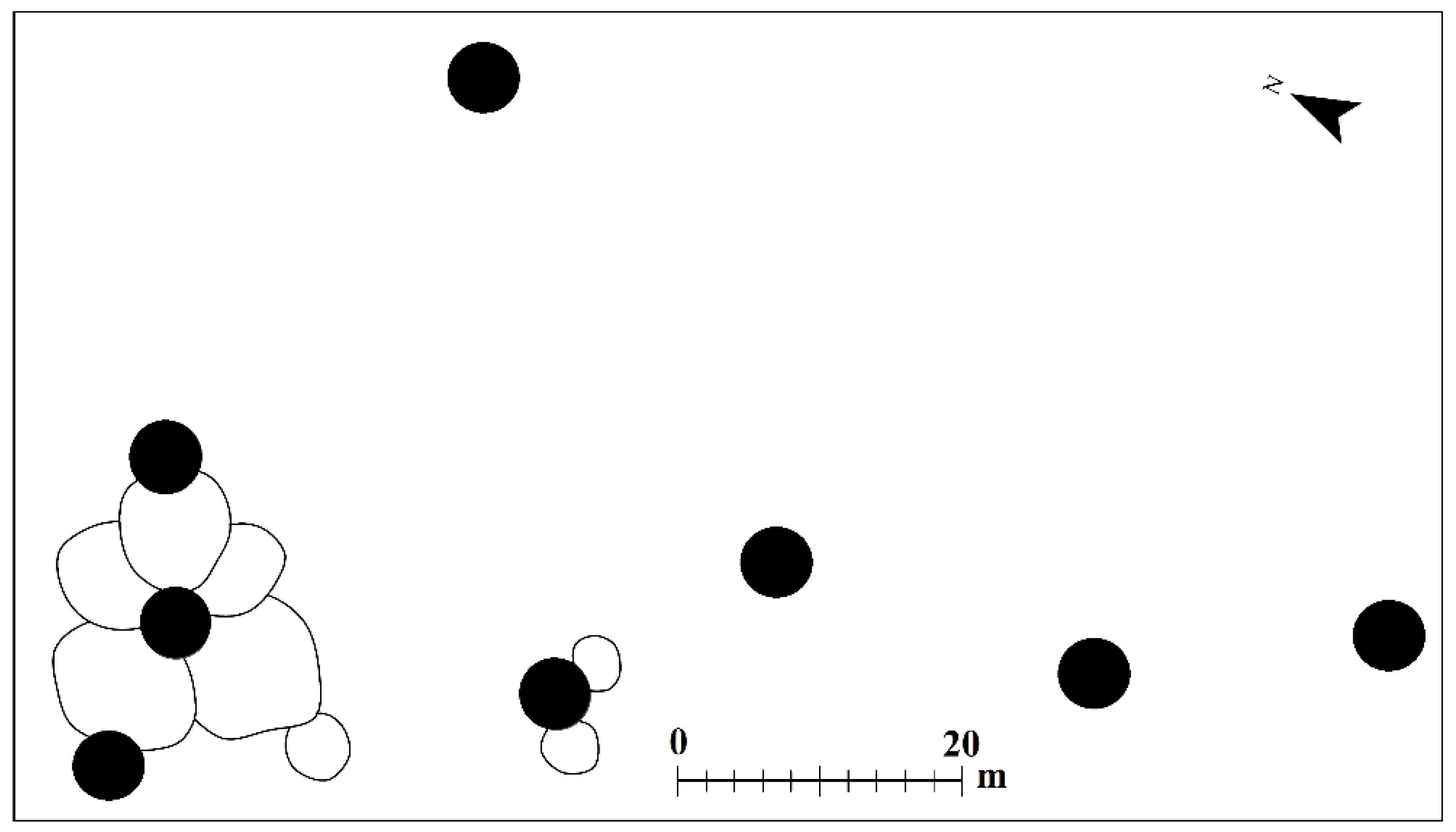
3.1. Detailed Mapping of the Features

The methodological center of gravity with regard to the question of what is an “archaeological site” as a basis for further research of any kind is the necessity to return to the field to complete the gathering of data, in keeping with the goals of the research and without reference to the technological means employed to assist the research. There are two reasons for this: One is that not everything can be seen remotely. In light of the experience accumulated in archaeological surveys in the more distant past, and that which has emerged from the current mapping project, no substitute can be offered for a field-walking survey, because such a survey—which also depends on accumulated experience—is the only way to identify the details and nature of the features scattered on the edges of the site. In contrast, the use of remote control only, as noted above, does not reveal all the features, and even if some or all of them can be distinguished, their nature cannot be securely ascertained. This issue is critical, given that features of this type are the ones that reflect the association with the environment. The second is that orientation in the tangles of data depends entirely on expertise in the subject, and the conclusion for now is that there is no technological substitute for basic physical presence in the field.
As has been detailed above, the remains were mapped as a basis for continued multidisciplinary studies, of the kind already implemented and described in notes 6–12, in which use was made of additional advanced technologies.

3.2. The Challenge of Sorting the Features into Appropriate Assemblages

A direct result of detailed mapping of remains is the appearance of features from different periods that have accumulated alongside each other. The first challenge is to separate the tangle of remains into correlated units, such as settlements and their specific features. Meeting this challenge relies on the accumulation of field experience, especially regarding the uniformity of their distribution.
The challenge of bringing order to the mixture of remains is more a matter of correlating the components of the remains than a chronological issue. Features such as cisterns, dams, winepresses, and other elements are open-air, and their direct dating, as noted above, is problematic. Calendrical dates alone, even if they are the result of advanced dating technology, are not the key to reconstructing a settlement pattern, because in the framework of the same “period”, as noted, a number of settlement complexes might have existed alongside each other. Compelling them to fit into a “period” only obscures the general picture. Suffice it to mention one example from the Early Bronze Age: As early as 1970 it was determined that in the deserts of the southern Levant four settlement complexes can be identified [66]. It was noted that the complexes were entirely different from each other, each with its own settlement history and cultural characteristics, such as Egyptian and Canaanite, with reference to the desert between Arad and southern Sinai, mentioned above.

3.3. Multidisciplinary Collaboration

The most prominent conclusion from the mapping project, which manifested itself right from the beginning, was that studying the tangle of remains only from the archaeological aspect does not properly take advantage of the data. It seems that the goal should be not only to increase the resolution of the documentation of the archaeological remains, but also to incorporate them in an environmental study. Such a study would involve, for example, an examination of soil and water, and even the geopolitical environment, reflected by the fortresses and road stations, which in many cases do not reflect an association with their natural environment.
Augmentation of the archaeological data, which can narrow the gap between such data and progress in dating technologies and remote sensing, also requires the users of these advanced technologies to develop an awareness of the resolution of the data, integrating it into the framework of an interdisciplinary study. For example, as noted above, the conclusion that no agricultural activities were identified in the Iron Age was based on a limited examination that ignored the abundance of data connected to agricultural activity in that period. The situation is no different with regard to the dating of the cistern alongside Atar Haro’ah Fortress from the Iron Age in the Negev Highlands, which OSL testing of the debris in the cistern dated from the Early Muslim period to the Ottoman period [67]. The conclusions of the study did not take into account the cleaning of ancient cisterns for reuse, known in all periods. For example, a cistern from the Byzantine period in Shivta was dated based on an examination of the debris within it to the Ottoman period [68] (p. 120). However, the dating was determined based on the cleaning of the ancient cistern by recent Bedouin. In that same context, on the inside wall of another cistern at Shivta, an inscription was found dating to the year 600 CE, describing its cleaning [69]. With regard to the cistern at Atar Haro’ah Fortress, examination of the distribution of cisterns of this type, according to the methodology used here, clearly indicates an association with sites from the Iron Age. It is this examination that led in the past to attribution of these cisterns to the Iron Age and not to their direct dating [20] (pp. 151–153). Another example is the attempt to incorporate detailed mapping of agricultural systems that did not include the settlements and installations on their margins, together with data from an old, standard survey in which only settlements were marked as central points and classified by “periods” [11]. It was found that geomorphological and hydrological calculations conformed to the mapping of the agricultural systems, but this was not the case when attempting to associate these systems with settlements. As noted, the source of information on the settlements is an old survey, in which they were marked as points, and it is impossible to indicate any association of any of these settlements with agricultural installations because the data did not relate at all to the components of the sites and the nature of these sites was not at all clear.
Given the rapid development of accompanying studies and remote sensing, it seems no exaggeration to say that archaeological data are lagging behind with regard to the distribution of the remains. Therefore, it seems that only detailed documentation, which requires investment in fieldwork, will close the gap, incorporating multidisciplinary research to achieve the best result.

Funding

The author received no financial support for the publication of this article. The fieldwork of the research program between 2004 and 2016 was made possible by grants from the International Arid Lands Consortium (IALC): http://www.mnemotrix.com/adasr, https://ialc.world/projects/ancient-desert-agriculture-systems-revived, (accessed on 30 May 2022) and by the Krauthammer, Kushitzky and Moskowitz foundations of behalf of Martin Szuss Department of the Land of Israel and Archaeology Studies in Bar Ilan University, with collaboration of the Israel Antiquities Authority.

Institutional Review Board Statement

Not applicable.

Informed Consent Statement

Not applicable.

Data Availability Statement

The above-mentioned website of the Israel Antiquities Authority Survey was established by and has been managed by O. Sion. For the past years. Sion has been conducting an extensive remote sensing project in the Negev, which has focused on sophisticated run-off water agricultural systems [70]. I would like to thank O. Sion for the information he provided, and for his permission to mention his work in this paper.

Conflicts of Interest

The author declares no conflict of interest.

References

  1. Palmer, E.H. The Desert of the Exodus; Cambridge: Cambridge, UK, 1871. [Google Scholar]
  2. Glueck, N. Rivers in the Desert, Hakibbutz Hameuchad; The University of Chicago Press: Jerusalem, Isreal, 1970. (In Hebrew) [Google Scholar]
  3. Glueck, N. Archaeological Exploration in the Negev in 1959. Am. Sch. Orient. Res. 1960, 159, 3–14. [Google Scholar] [CrossRef]
  4. Haiman, M. Archaeological Survey of Israel, Map of Har Hamran South West (198); Department of Antiquities: Jerusalem, Israel, 1986. [Google Scholar]
  5. Ilan, Z. Traces of Early Agriculture in the Region of Katef Beer-Sheva. Nofim 1980, 13–14, 27–40. (In Hebrew) [Google Scholar]
  6. Ackermann, O.; Svoray, T.; Haiman, M. Nari (calcrete) outcrop contribution to ancient agricultural terraces in the Southern Shephelah, Israel: Insights from digital terrain analysis and a geoarchaeological field survey. J. Archaeol. Sci. 2008, 35, 930–941. [Google Scholar] [CrossRef]
  7. Haiman, M. Dating the agricultural terraces in the southern Levantine deserts—The spatial-contextual argument. J. Arid Environ. 2012, 86, 43–49. [Google Scholar] [CrossRef]
  8. Haiman, M. The Challenge of Digitized Survey Data. In Cyber—Archaeology and Grand Narratives; Levy, T.E., Jones, I.W.N., Eds.; Springer: Berlin/Heidelberg, Germany, 2018; pp. 111–122. [Google Scholar]
  9. Haiman, M. From Palmer to GIS: Two Survey Methods on Trial in the Negev Desert. In Exploring the Holy Land, 150 Years of the Palestine Exploration Fund; Gurevich, D., Kidron, A., Eds.; Equinox Publishing: Sheffield, UK, 2018; pp. 179–198. [Google Scholar]
  10. Haiman, M.; Argaman, E.; Stavi, I. Ancient Runoff Harvesting Agriculture in the Aarid Beer Sheva Valley, Israel: An Interdisciplinary Study. Holocene 2020, 30, 196–204. [Google Scholar] [CrossRef]
  11. Manspeizer, N.; Haiman, M.; Ackermann, O.; Tendler, A.; Birkenfeld, M.; Levy, D.; Marcus-Peretz, J. Landscape Archaeology at Aneva Stream Israel: Deconstructing a General Trend in Agricultural Intensification with GIS. In Remote Sensing and Regression Analysis; Digital Archaeology New, Research and Advanced Technologies, Collection of Articles from a Joint Seminar Day; Birkenfeld, M., Garfinkel, Y., Eds.; GIS Research Branch at the Israel Antiquities Authority, The Institute of Archeology of the Hebrew University: Jerusalem, Israel, 2020; pp. 5–24. [Google Scholar]
  12. Stavi, I.; Ragolsky, G.; Haiman, M.; Porat, N. Ancient to Recent-Past Rrunoff Harvesting Agriculture in the Hyper-Arid Arava Valley: Dating and Insights. Holocene 2021, 31, 1047–1054. [Google Scholar] [CrossRef]
  13. Aharoni, Y.; Evenari, M.; Shanan, L.; Tadmor, N.H. The Ancient Desert Agriculture of the Negev, V. An Israelite Agri-cultural Settlement at Ramat Maṭred. Isr. Explor. J. 1960, 23–36, 97–111. [Google Scholar]
  14. Evenari, M.; Shanan, L.; Tadmor, N. The Negev, The Challenge of the Desert; Harvard University Press: Cambridge, MA, USA, 1971. [Google Scholar]
  15. Nevo, Y.D. Pagans and Herders, a Re-Examination of the Negev Runoff Cultivation Systems in the Byzantine and Early Arab Periods; Midreshet Ben Gurion: Sde Boqer, Israel, 1991. [Google Scholar]
  16. Avni, G.; Porat, N.; Avni, Y. Byzantine–Early Islamic agricultural systems in the Negev Highlands: Stages of development as interpreted through OSL dating. J. Field Archaeol. 2013, 38, 332–346. [Google Scholar] [CrossRef]
  17. Yair, A. Environmental effects of loess penetration into the northern Negev Desert. J. Arid Environ. 1987, 13, 9–24. [Google Scholar] [CrossRef]
  18. Cohen, R. Excavations at Ḥorvat Ḥaluqim. Atiqot 1976, 11, 34–50. [Google Scholar]
  19. Cohen, R. Archaeological Survey of Israel, Map of Sede-Boqer—East (168); Archaeological Survey of Israel: Jerusalem, Israel, 1981. [Google Scholar]
  20. Cohen, R.; Cohen-Amin, R. Ancient Settlement of the Negev Highlands; Israel Antiquities Authority Reports 20; American Oriental Society: Jerusalem, Israel, 2004; Volume II. [Google Scholar]
  21. Bruins, J.H. Desert Environment and Agriculture in the Central Negev and Kades-Barnea During Historical Times; Bruins: Nijerek, The Netherlands, 1986. [Google Scholar]
  22. Bruins, H.J.; van der Plicht, J. Desert Settlement through the Iron Age: Radiocarbon Dates from Sinai and the Negev Highlands. In The Bible and Radiocarbon Dating: Archaeology, Text and Science; Levy, T.E., Higham, T., Eds.; Routledge: London, UK, 2005; pp. 349–366. [Google Scholar]
  23. Bruins, H.J.; van der Plicht, J. Iron Age Agriculture—A Critical Rejoinder to Settlement Oscillation in the Negev Highlands Revisited: The Impact of Microarchaeological Methods. Radiocarbon 2017, 59, 1–16. [Google Scholar] [CrossRef]
  24. Bruins, H.J.; van der Plicht, J.; Haiman, M. Desert Habitation History by C14 Dating of Soil Layers in Rural Building Structures (Negev, Israel): Preliminary Results from Horvat Haluqim. Radiocarbon 2012, 54, 391–406. [Google Scholar] [CrossRef] [Green Version]
  25. Ben-Yosef, E.; Be’eri, R.; Davidovich, U. Trip 3: Copper Exploitation in the Aravah and Ancient Activities in the Negev Highands in the Bronze and Iron Ages. In Proceedings of the Conference of the Israeli Geological Society, Yeruham, Israel, 3–5 May 2021; pp. 5–73. [Google Scholar]
  26. Cohen, R. Archaeological Survey of Israel, Map of Sede-Boqer—West (167); Archaeological Survey of Israel: Jerusalem, Israel, 1985. [Google Scholar]
  27. Nevo, Y.D. Sde Boqer and the Central Negev, 7th–8th Century; The Hebrew University of Jerusalem: Jerusalem, Israel, 1985. [Google Scholar]
  28. Haiman, M. Archaeological Survey of the Kadesh Barnea Vicinity: ‘Ein el-Qudeirat and ‘Ein Qadis. In Excavations at Kadesh Barnea (Tell El-Qudeirat) 1976–1982; Israel Antiquities Authority Reports, 34/1; Cohen, R., Bernick-Greenberg, H., Eds.; Israel Antiquities Authority: Jerusalem, Israel, 2007; pp. 307–361. [Google Scholar]
  29. Boaretto, E.; Finkelstein, I.; Shahack-Gross, R. Radiocarbon Results from the Iron IIA Site of Atar Haroa in the Negev Highlands and their Archaeological and Historical Implications. Radiocarbon 2010, 52, 1–12. [Google Scholar] [CrossRef] [Green Version]
  30. Shahack-Gross, R.; Finkelstein, I. Iron Age Agriculture in the Negev Highlands? Methodological and Factual Comments on Bruins and Van Der Plicht 2017a (RadiocarbonVol. 59, Nr. 1). Radiocarbon 2017, 59, 1227–1231. [Google Scholar] [CrossRef]
  31. Haiman, M. The Iron Age II Sites of the Western Negev Highlands. Isr. Explor. J. 1994, 44, 36–61. [Google Scholar]
  32. Cohen, R.; Bernick-Greenberg, H. Excavations at Kadesh Barnea (Tell el-Qudeirat) 1976–1982; Israel Antiquities Authority Reports 34; Israel Antiquities Authority: Jerusalem, Israel, 2007. [Google Scholar]
  33. Ore, G. Characteristics and Preservation of Cross-Channel Terraces in Ancient Agricultural Runoff Systems: Human-Environment Relationships in the Negev Highlands. Master’s Thesis, Ben Gurion University of the Negev, Beersheba, Israel, 2008. (Hebrew with English Summary). [Google Scholar]
  34. Galilee, E. Life Cycle in a Nomadic Society: Burial Patterns Among the Negev Bedouin as a Reflection of Spatial and Social Changes, 1900–1966. Ph.D. Thesis, The Hebrew University, Jerusalem, Israel, 2013. [Google Scholar]
  35. Abu-Rabia, A. The Negev Bedouin and Livestock Rearing; Berg Publishers Limited: Oxford, UK, 1994. [Google Scholar] [CrossRef]
  36. Ben-David, Y.; Orion, E. Lifestyle and Patterns of Existence of the ‘Azazme Bedouins in the Negev Highlands, the Late 19th and Early 20th Century CE. In Studies in the Archaeology of Nomads; Aḥituv, S., Ed.; Israel Antiquities Authority and Ben-Gurion University of the Negev Press: Beer Sheva, Israel, 1998; pp. 175–216. (In Hebrew) [Google Scholar]
  37. Haiman, M. Bedouin Sheep pens in Forests Near Modiin as a Base for Study the Ancient Pens in the Negev and Sinai. Available online: www.kkl.org.il/forest-online-journal (accessed on 31 December 2022).
  38. Shahack-Gross, R.; Marshall, F.; Weiner, S. Geo-Ethnoarchaeology of Pastoral Sites: The Identification of Livestock Enclosures in Abandoned Maasai Settlements. J. Archaeol. Sci. 2003, 30, 439–459. [Google Scholar] [CrossRef] [Green Version]
  39. Noi-Meir, E. An Ecological Analysis of the Bedouin Grazing System. Notes Bedoin 1976, 7, 10–18. (In Hebrew) [Google Scholar]
  40. Bailey, C. The Negev in the Nineteenth Century: Reconstructing History from Bedouin Oral Tradition; Asian and African Studies; Institute of Middle Eastern Studies, University of Haifa: Haifa, Israel, 1980; Volume 14, pp. 35–80. [Google Scholar]
  41. Marx, E. Bedouin of Negev; Manchester University: Manchester, UK, 1967. [Google Scholar]
  42. Bar-Zvi, S.; Ben-David, Y. The Negev Bedouins in the Thirties and Forties of the Twentieth Century: A Semi Nomadic Society. Stud. Geogr. Isr. 1974, 10, 107–136. (In Hebrew) [Google Scholar]
  43. Ashkenazi, E.; Avni, Y.; Chen, Y. The Vitality of Fruit Trees in Ancient Bedouin Orchards in the Arid Negev Highlands (Israel): Implications of Climatic Change and Environmental Stability. Quat. Int. 2020, 545, 73–86. [Google Scholar] [CrossRef]
  44. Amiran, R.; Beit-Arieh, I.; Glass, J. The Interrelationship between Arad and Sites in South Sinai in the Early Bronze Age II. Isr. Explor. J. 1973, 23, 193–197. [Google Scholar]
  45. Beit-Arieh, Y. Archaeology of Sinai, The Ophir Expedition. In Monograph Series of the Institute of Archaeology of Tel Aviv; University Tel-Aviv: Tel Aviv, Israel, 2003; Volume 21. [Google Scholar]
  46. Rosen, S.A. Tabular Scraper Trade: A Model of Material Cultural Dispersion. Bull. Am. Sch. Orient. Res. 1983, 249, 79–86. [Google Scholar] [CrossRef]
  47. Rosen, S.A. Lithic after the Stone Age: A Handbook of Stone Tools from the Levant; Alta Mira: Walnut Greek, CA, USA, 1997. [Google Scholar]
  48. Barket, T.M.; Bell, C.A. Tabular Scrapers: Function Revisited. Near East. Archaeol. 2011, 74, 56–59. [Google Scholar] [CrossRef]
  49. Yerkes, R.W.; Barkai, R.; Gopher, A.; Zutovski, K. The use of fan scrapers: Microwear evidence from Late Pottery Neolithic and Early Bronze Age, Ein Zippori, Israel. J. Lithic Stud. 2016, 3, 185–205. [Google Scholar] [CrossRef] [Green Version]
  50. Kolska Horwitz, L. Early Bronze Age Fauna from Three Sites in the Negev Highlands. In Excavations in the Western Negev Highlands, Results from the Negev Emergency Survey 1979–89; Saidel, B.A., Haiman, M., Eds.; BAR Publishing: Oxford, UK, 2014; pp. 137–144. [Google Scholar]
  51. Amiran, R. Early Arad; Israel Exploration Society: Jerusalem, Israel, 1978. [Google Scholar]
  52. Saidel, B.A. An alternative date for the Nahal Mitnan Cairn Field in the Western Negev Highlands: Identifying an Early Timnian tumuli tradition in the Southern Levant. Paléorient 2017, 43, 125–140. [Google Scholar] [CrossRef]
  53. Bar-Yosef, O.; Belfer-Cohen, A.; Goren, A.; Hershkovitz, I.; Ilan, O.; Mienis, H.K.; Sass, B. Nawamis and Habitation Sites near Gebel Gunna, Southern Sinai. Isr. Explor. J. 1986, 361, 21–167. [Google Scholar]
  54. Cohen, R. Ancient Settlement of the Central Negev; Israel Antiquities Authority Reports, 6; Israel Antiquities Authority: Jerusalem, Israel, 1999; (Hebrew with English Summary). [Google Scholar]
  55. Kolska Horwitz, L.; Rosen, S.A.; Bocquentin, F. A Late Neolithic Equid Offering from the Mortuary-Cult Site of Ramat Sa-haronim in the Central Negev, Mitekufat Haeven. J. Isr. Prehist. Soc. 2011, 11, 71–81. [Google Scholar]
  56. Porat, N.; Rosen, S.A.; Boaretto, E.; Avni, Y. Dating the Ramat Saharonim Late Neolithic desert cult site. J. Archaeol. Sci. 2006, 33, 1341–1355. [Google Scholar] [CrossRef]
  57. Rosen, S.A.; Avni, Y.; Bocquentin, F.; Porat, N. Investigations at Ramat Saharonim: A Desert Neolithic Sacred Precinct in the Central Negev. Bull. Am. Sch. Orient. Res. 2007, 346, 1–27. [Google Scholar] [CrossRef]
  58. Erickson-Gini, T.; Porat, N. Sheluhat Qadesh Barne‘a. Hadashot Arkheologiyot 2018, 130. Available online: http://hadashot-esi.org.il/report_detail.aspx?id=25410&mag_id=126 (accessed on 31 December 2018).
  59. Rosen, S.A. Revolutions in the Desert: The Rise of Mobile Pastoralism in the Negev and the Arid Zones of the Southern Levant; Routledge: New York, NY, USA, 2017. [Google Scholar]
  60. Haiman, M. Churches and Agriculture in the Land of Israel during the Byzantine Period: Data from the Mapping Project of Ancient Agriculture. In New Studies of Jerusalem; Baruch, A., Levy-Raiper, A., Faust, A., Eds.; Bar Ilan University: Ramat Gan, Israel, 2011; pp. 403–426. (In Hebrew) [Google Scholar]
  61. Yair, A. The Ambiguous Impact of Climate Change at a Desert Fringe: Northern Negev, Israel. In Environmental Change in Drylands: Biogeographical and Geomorphological Perspectivs; Millington, A.C., Pye, K., Eds.; John Wiley & Sons Ltd.: Hoboken, NJ, USA, 1994; pp. 199–227. [Google Scholar]
  62. Guérin, V. Description Géographique Historique et Archéologique de la Palestine; Ben Zvi Insitute: Jeruaslem, Israel, 1984; Volume 6. [Google Scholar]
  63. Shadman, A. The Settlement Pattern of the Rural Landscape between Nahal Rabbah andNahal Shiloh during the Hellenistic, Roman and Byzantine Periods. Ph.D. Thesis, Bar-Ilan University, Ramat Gan, Israel, 2016. (Hebrew with English Summary). [Google Scholar]
  64. Dayan, A. Monasteries in the Northern Judean Shephelah and the Samaria Western Slopes During the Byzantine and the Early Islamic Periods. Ph.D. Thesis, Bar Ilan University, Ramat-Gan, Israel, 2015. (Hebrew with English Summary). [Google Scholar]
  65. Taxel, I. Rural Monasticism at the Foothills of Southern Samaria and Judaea in the Byzantine Period Asceticism, Agriculture and Pilgrimage. Bull. Anglo-Isr. Archaeol. Soc. 2008, 26, 57–73. [Google Scholar]
  66. Amiran, R.; Alon, D.; Arnon, C.; Gavish, D.; Amiran, D.H.K. The Arad Countryside. Levant 1980, 12, 22–29. [Google Scholar] [CrossRef]
  67. Junge, A.; Lomax, J.; Shahack-Gross, R.; Finkelstein, I.; Fuchs, M. Chronology of an ancient water reservoir and the history of human activity in the Negev Highlands, Israel. Geoarchaeology 2018, 33, 695–707. [Google Scholar] [CrossRef]
  68. Tepper, Y.; Porat, N.; Bar-Oz, G. Sustainable farming in the Roman-Byzantine period: Dating an advanced agriculture system near the site of Shivta, Negev Desert, Israel. J. Arid Environ. 2020, 177, 104134. [Google Scholar] [CrossRef]
  69. Tsuk, T. Water Supply in Shivta in the Byzantine Period. Qadmoniot 2003, 125, 18–24. (In Hebrew) [Google Scholar]
  70. Sion, O.; Rubin, R. Horvat Sa’adon and its Environs: A LargebSettlement, Satellite Settlements and Agricultural Systems in the Negev in Antiquity, Strata. Bull. Anglo-Isr. Archaeol. Soc. 2020, 38, 125–170. [Google Scholar]
Figure 1. Map of the southern Levant and sites mentioned in the article.
Heritage 05 00061 g001
Figure 2. Horvat Haluqim (Site 98) and surroundings.
Heritage 05 00061 g002
Figure 3. The Horvat Haluqim Fortress (2) and the nearby terraced wadi.
Heritage 05 00061 g003
Figure 4. Enclosed structures: (A) recent Bedouin structure near Modi’in; (B) Early Bronze Age structure in the Negev Highlands (after [4]).
Heritage 05 00061 g004
Figure 5. A section of the Nahal Mitnan cairn field (after [4]).
Heritage 05 00061 g005
Figure 6. The southern periphery of Horvat Hamam.
Heritage 05 00061 g006
Figure 7. Orthophoto of the area in Figure 6.
Heritage 05 00061 g007
Figure 8. The structure identified as a monastery.
Heritage 05 00061 g008
Publisher’s Note: MDPI stays neutral with regard to jurisdictional claims in published maps and institutional affiliations.

