Article

Peatland Development, Vegetation History, Climate Change and Human Activity in the Valdai Uplands (Central European Russia) during the Holocene: A Multi-Proxy Palaeoecological Study

by
Yuri A. Mazei
1,2,
Andrey N. Tsyganov
1,2,*,
Maxim V. Bobrovsky
3,
Natalia G. Mazei
4,
Dmitry A. Kupriyanov
4,5,
Mariusz Gałka
6,
Dmitry V. Rostanets
1,
Kseniya P. Khazanova
1,
Tamara G. Stoiko
7,
Yulia A. Pastukhova
7,
Yulia A. Fatynina
7,
Alexander A. Komarov
7,
Kirill V. Babeshko
7,
Anastasiya D. Makarova
1,
Damir A. Saldaev
8,
Elya P. Zazovskaya
9,
Maria V. Dobrovolskaya
5 and
Alexei V. Tiunov
2
1
Faculty of Biology, Lomonosov Moscow State University, 1, Leninskie Gory, Moscow 119991, Russia
2
A.N. Severtsov Institute of Ecology and Evolution, Russian Academy of Sciences, 33 Leninsky prospekt, Moscow 119071, Russia
3
Institute of Physicochemical and Biological Problems of Soil Science, Russian Academy of Sciences, Pushchino, 2 Insitutskaya Street, Pushchino 142290, Russia
4
Faculty of Geography, Lomonosov Moscow State University, 1, Leninskie Gory, Moscow 119991, Russia
5
Institute of Archeology, Russian Academy of Sciences, 19 Dm. Ulyanova Street, Moscow 117992, Russia
6
Faculty of Biology and Environmental Protection, University of Lodz, 90-237 Łódź, Poland
7
Faculty of Physics, Mathematics and Natural Sciences, Penza State University, 40, Krasnaya Street, Penza 440026, Russia
8
Biological Faculty, Shenzhen MSU-BIT University, 1, International University Park Road, Dayun New Town, Longgang District, Shenzhen 517182, China
9
Institute of Geography, Russian Academy of Sciences, 29 Staromonetniy Lane, Moscow 119017, Russia
*
Author to whom correspondence should be addressed.
Submission received: 4 November 2020 / Revised: 24 November 2020 / Accepted: 30 November 2020 / Published: 3 December 2020
(This article belongs to the Special Issue Ecology, Biogeography and Evolutionary Biology of Peatlands)

Abstract

:
Peatlands are remarkable for their specific biodiversity, crucial role in carbon cycling and climate change. Their deposits preserve organism remains that can be used to reconstruct long-term ecosystem and environmental changes as well as human impact in the prehistorical and historical past. This study presents a new multi-proxy reconstruction of the peatland and vegetation development investigating climate dynamics and human impact at the border between mixed and boreal forests in the Valdai Uplands (the East European Plain, Russia) during most of the Holocene. We performed plant macrofossil, pollen, testate amoeba, Cladocera, diatom, peat humification, loss on ignition, carbon and nitrogen content, δ13C and δ15N analyses supported by radiocarbon dating of the peat deposits from the Krivetskiy Mokh mire. The results of the study indicate that the wetland ecosystem underwent a classic hydroserial succession from a lake (8300 BC–900 BC) terrestrialized through a fen (900 BC–630 AD) to an ombrotrophic bog (630 AD–until present) and responded to climate changes documented over the Holocene. Each stage was associated with clear changes in local diversity of organisms responding mostly to autogenic successional changes during the lake stage and to allogenic factors at the fen-bog stage. The latter can be related to increased human impact and greater sensitivity of peatland ecosystems to external, especially climatic, drivers as compared to lakes.

Graphical Abstract

1. Introduction

Peatlands are wetland ecosystems characterized by an accumulation of organic matter as peat due to unbalanced net primary production and decomposition [1]. Peatlands are remarkable for their specific biodiversity and ecosystem functioning [2] and form a major global terrestrial pool of organic matter and carbon (C), storing around 547 Pg C (473–621 Pg) [3]. The modern distribution of boreal peatlands in Europe coincides with the areas that were covered by the Fennoscandian ice sheet during the last glacial maximum, and peatland development is mostly restricted to conditions related to the deglaciation process [4]. The process of peatland development is well described in terms of succession theory [5]. Hydroserial succession is the most frequent and typical form of autogenic development in peatlands [6]. The open water to fen transition observed at terrestrialized sites is the result of gradual infilling of the basin with mineral and organic materials. The subsequent succession from fen to bog is the result of local peat accumulation that gradually lifts the surface of the peatland above the influence of the groundwater [4]. While hydroserial succession is a very widespread and common phenomenon, its main driving forces and mechanisms remain debated due to numerous regional patterns related to unique combinations of allogenic (e.g., climate, edaphic conditions and fire) and autogenic (e.g., peat accumulation rate and acidification) factors [4,5,7].
The waterlogged and anoxic conditions within peatlands can result in the preservation of a diverse range of fossil materials that have long been central to understanding patterns of the ecosystem and environmental changes as well as human impact [8]. Such long-term records of ecological processes cannot be attained through “real-time” monitoring projects and provide unique opportunities to understand the development of peatland ecosystems themselves [6] and to elucidate past changes in vegetation and human impact upon the environment, air temperature, hydrology and carbon cycling [9]. The specific conditions in peat deposits can preserve plant remains that form peat, pollen and spores from plants that grew on and around the peatland, fragments of arthropods (insects, crustaceans), fungal spores and hyphae, protists (testate amoebae, diatoms and other algae) that can be used as proxies for the reconstructions [1,8]. Recently, significant progress has also been made in the application of organic and inorganic geochemistry and stable isotope analyses to peat deposits (e.g., greater concentration of 13C, i.e., less negative δ13C values, indicate wetter conditions) [10,11].
Peat deposits of ombrotrophic bogs preserve records of past hydrological changes, as their growing surface is directly coupled to rainfall, temperature and humidity [12]. Changes in bog surface wetness can be reconstructed using a range of techniques, including the composition of the peat-forming vegetation [13,14], the degree of peat decay (more decomposed peat is generally formed under dry conditions) [15] and testate amoeba analysis (various taxa prefer dry or wet substrates) [16,17]. Many pollen-based methods are used to reconstruct long-term temperature and climatic moisture variability at regional and global scales [18,19]. Pollen and spores also reflect wider regional vegetation changes, which can, in turn, be closely linked to archaeological evidence for human activity and cultural change [20], alongside microscopic and macroscopic charcoal relating to both on and off-site fire histories [21]. Where palaeoenvironmental analyses are carried out in association with archaeological sites, the combined records can provide exceptional, closely integrated evidence of the timing, patterns and processes of cultural and environmental change both within a particular peatland and for the wider landscape [8].
Palaeoenvironmental reconstructions from across Eurasia show that changes in ecosystems and environment during the Holocene were characterized by high spatial variability [22,23]. Although Russia contains one of the largest areas of peatland in the world [24], there were remarkably few peat-based palaeoecological studies using proxies other than pollen [7,25,26,27]. In particular, raised bogs in the East European Plain are affected by the continental climate conditions in contrast with better studied Atlantic or Baltic raised bogs of Northern, Western and Eastern Europe [28,29,30,31]. Past human impact on these ecosystems that cover large areas in this region [24] is also insufficiently recognized. Our focus is on the multiproxy palaeoecological record from a peatland in the Valdai Uplands, the East European Plain (Central European Russia). The area of the present study is located in the marginal part of the Weichselian ice sheet, almost on the border of the Late Glacial Maximum and, thus, provides an important case in understanding the age of peatlands, their developmental stages and human impact. Earlier studies in the southern parts of Valdai Uplands [27,32] and adjacent lowlands [33,34] indicated that peatlands developed through a classic hydroserial succession in the early Holocene with a sharp decline in mineral input by 4200 BC followed by an abrupt transition from fen to bog vegetation around 3500 BC. The evidence for farming and human occupation in the region was detected in pollen records since 500 BC, however, widespread agriculture was observed from the 18th century AD only [32]. Human activity related to deforestation had a crucial impact on the development of the peatlands in the area during the last three centuries [32]. Nonetheless peatlands showed strong resilience and recovered after human impact in 50–70 years [35]. Overall, the number of Holocene studies in the Valdai Uplands is still limited and, in some cases, different proxies gave contrasting evidence of the timing and abruptness of the ecosystem and climatic changes that calls for future studies focusing on quantifying reconstructions and replicating results between cores and sites. Thus, the main aim of the study is to reconstruct peatland and surrounded vegetation development, climate dynamics and human impact during the Holocene in the central part of the Valdai Uplands using a multi-proxy approach.

2. Materials and Methods

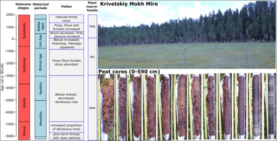
2.1. Study Region and Site

The study was performed in the north of the Valdai Uplands located in the central part of the East European Plain (Figure 1). The area is situated in the southern subzone of taiga forests and represents a hilly plain (150–250 m a.s.l. with a maximum elevation of 275 m) moderately dissected by gullies, valleys of small streams and depressions. Quaternary deposits are formed by moraine materials and fluvioglacial sands. The area is characterized by a large number of lakes and mires developed in depressions between moraine hills. The climate is temperate and moderately continental with relatively cold winters (mean January temperature: −5.9 °C) and warm summers (mean July temperature: 18.3 °C) (Toropets weather station, 80 km southwest from the study site, 1988–2019; http://www.meteo.ru). The mean annual temperature is +5.6 °C. Annual precipitation is about 761 mm. The area is located on the border between the mixed and boreal forests with vegetation dominated by Pinus sylvestris (Scots pine) and Picea abies (European spruce) with the participation of Betula spp. (birch) and Populus tremula (common aspen). Besides, Sorbus aucuparia (rowan), Frangula alnus (alder buckthorn) and Juniperus communis (common juniper) can be observed in sparse undergrowth. Vaccinium myrtillus (European blueberry), V. vitis-idaea (lingonberry), Pteridium aquilinum (eagle fern) and green mosses prevailed on the forest floor. Among soils, Albic Podzols (with a spodic illuviation horizon under a subsurface horizon that has the appearance of ash) are widespread on watersheds and slopes; Albic Retisols (with a clay illuviation horizon and an interfingering of bleached coarser textured soil material into the illuviation horizon forming a net-like pattern) are also present [36]. Archaeological sites of the Final Paleolithic, Mesolithic, Neolithic, Early Iron Age and Middle Ages were found in the study area [37,38]. The archaeological evidence of the population during the Bronze Age does not yet have strong evidence [39].
The study site is an almost round medium-size mire (linear dimensions 200 × 300 m) (57.10460° N, 032.35895° E) formed in a depression between moraine hills. The surface of the mire is covered by a regular ridge-hollow pattern. The overstorey is dominated by rare and low (approximately 2 m heigh) Pinus sylvestris trees. The shrub layer is formed by Chamaedaphne calyculata (cassandra), Ledum palustre (wild rosemary) and Andromeda polifolia (bog-rosemary). The field layer mainly consists of Scheuchzeria palustris (pod grass, mostly in hollows) with rare Carex limosa (bog-sedge). The moss layer is formed by Sphagnum spp. (peat moss).

2.2. Sampling

Peat deposits were extracted during two field campaigns in July 2018 and 2019 with a Russian corer (5 cm in diameter, 50 cm long). The first time, one six-meter core was extracted from the peripheral part of the mire. The second time, a seven-meter core was extracted at the same sampling site. The cores were wrapped in plastic and aluminum foil, placed in boxes and stored at 4 °C before further analyses. In the laboratory, the cores were subsampled in 5-cm continuous slices for a multi-proxy palaeoecological analysis: the six-meter core was used for pollen, plant macrofossil, testate amoebae, Cladocera, loss on ignition (LOI), peat humification, carbon (C), nitrogen (N), and stable isotope (δ13C and δ15N) analyses; the seven-meter core was used for charcoal and diatom analyses. The bottom of the core (600–700 cm) was additionally subsampled for pollen, plant macrofossils and LOI analyses. The latter was used to correlate the cores.

2.3. Chronology

The chronology of the deposits was determined by accelerator mass spectrometer radiocarbon dating (AMS 14C) of eight samples (Table 1). The analysis was performed in the Laboratory of Radiocarbon Dating and Electron Microscopy in the Institute of Geography of the Russian Academy of Science (IG RAS). The radiocarbon dates were calibrated with the IntCal20 [40] using the package “clam” [41] in the R language environment [42]. The age-depth model was developed using the Bayesian-based package “rbacon” [43]. The age at the surface of the deposits (0 cm) was set to −68.5 yr (i.e., the date of the core retrieval). The program default settings were used for all priors. The dates are quoted in the text as 2σ-calibrated years BC/AD.

2.4. Loss on Ignition (LOI) and Peat Humification

LOI was determined following the procedures suggested by [44] (combusting 50 g of the samples at 550 °C for 5 h). Peat humification was analyzed using the standard alkali-extraction and colorimetry method [45]. The samples were dried (50 °C), weighted (0.2 g) and ground in an agate mortar. After this, they were placed in 100 mL of 8% NaOH and heated at 95 °C for 1 h. The extract was then diluted to 200 mL with distilled water and filtered (Whatman No. 1). The light absorbance of the filtrate (50 mL diluted to 100 mL with distilled water) was measured with a spectrophotometer (KFK-3-01-“ZOMZ”, JSC “Zagorsk Optical and Mechanical Plant”, Sergiev Posad, Russia) at a 540-nm wavelength. Greater values of light absorbance indicate more humified peat and vice versa. The obtained values of light absorbance were corrected for loss on ignition as D’ = D/LOI (where LOI is the loss on ignition as a proportion) to account for a lower organic matter content in mineral-rich samples.

2.5. Carbon (C), Nitrogen (N) and Stable Isotope Analyses

Peat material was dried at 50 °C for at least 48 h, homogenized using a ball mill and wrapped in tin foil (from 1500 to 2000 μg). Stable isotope analysis was conducted using a Thermo Delta V Plus continuous-flow IRMS (Thermo Scientific, Waltham, MA, USA) coupled with an elemental analyzer Flash 1112 located at the Joint Usage Centre in the Institute of Ecology and Evolution (Russian Academy of Sciences). The natural abundance of C and N isotopes was expressed in δ-notation relative to international standards (VPDB for C and atmospheric N2 for N): δ (‰) = [(Rsample/Rstandard) – 1] × 1000, where R is the molar ratio of heavy to light isotope in the sample and standard. Samples were analyzed with reference gas calibrated against IAEA reference materials USGS 40, USGS 41 and IAEA CH3. Drift was corrected using internal laboratory standards (casein and alfalfa leaves). The standard deviation of δ15N and δ13C values in standard materials (SD, n = 6) was <0.15‰. Along with stable isotope composition, total C and N content (as %) was measured.

2.6. Macrocharcoal Analysis

Samples for macro charcoal analysis were prepared following Mooney and Tinner [46]. Samples (volume of 1 cm3) were bleached with a water solution of NaOCl and were washed with distilled water using a sieve with a mesh size of 125 μm. All materials in the sieve were carefully transferred to labeled Petri dishes, and all charcoal particles were tallied under a dissecting light microscope at the magnification of 40×. Data processing of macro charcoal concentration was carried out in a modified version of the CharAnalysis software developed by Higuera et al. [47]. To determine fire episodes and fire frequency, the following parameters were used: CHAR—charcoal accumulation rate (pieces cm−2 yr−1), Cint—CHAR of interpolated record, Cback—low-frequency trend in Cint, Cpeak—high-frequency trends in Cint. We used the median sample resolution age (54 years) to interpolate the record. Fire episodes were defined as a ratio (Cpeak = Cint/Cback). These peaks were separated from background charcoal (Cback) using the smoothing method LOWESS (locally weighted scatter plot smoothing). A 1000-year window was applied to smoothen the record over for estimating Cback. The associated threshold value within the Cpeak component was set at the 90th percentile of a Gaussian mixture model.

2.7. Plant Macrofossils

Subsamples (15 cm3) for plant macrofossil analysis were washed and sieved under a warm-water spray using a 0.20-mm mesh sieve. Initially, the entire sample was examined with a stereomicroscope to obtain volume percentages of individual subfossil vascular plants and mosses. The subfossil carpological remains and vegetative fragments (leaves, rootlets and epidermis) were identified following Smith [48] and Mauquoy and van Geel [49] and were expressed as absolute numbers. The percentage volumes of the different vegetative remains and the Sphagnum species were estimated to the nearest 5%. The relative proportions of taxonomic groups of Sphagnum, which are of key importance for interpretations, were estimated on the basis of the branch leaves, which were investigated under the microscope on three 22 × 22 mm cover glasses. The identification of Sphagnum taxa to species level was performed separately on the basis of the stem leaves using identification keys [50,51]. Plant functional groups were distinguished, according to Tuittila et al. [31].

2.8. Pollen Analysis

Samples for pollen analysis (volume ~1 cm3) were treated using the acetolysis method [52]. The sample preparation included wet sieving through a 500 μm mesh, treatment with 10% KOH in a water bath for 5 min followed by repeated washing with distilled water, dehydration with ice-cold acetic acid and acetolysis followed by washing. Counting and identification of spores and pollen were carried out in temporary glycerin slides with a light microscope at 400× magnification according to the standard method [53]. At least 500 pollen grains in total were counted per sample. The relative abundance of pollen was calculated to the total pollen sum of arboreal pollen (AP) and non-arboreal pollen (NAP), excluding pollen and spores of aquatic plants. Pollen of aquatic plants and spores were also calculated in relation to this total. The pollen data were used to reconstruct the mean July temperature based on the pollen–climate calibration set derived from the European Modern Pollen Dataset [54] using the transfer functions developed by Salonen et al. [55]. A weighted averaging-partial least-squares model (WAPLS: 3-components, RMSEP = 1.73, Maximum bias = 5.90) was applied to square-root transformed species data. The analyses and visualization were implemented with the R packages “rioja” [56] and “analogue” [57].

2.9. Testate Amoeba Analysis

Testate amoebae were extracted following the method based on suspension in deionized water (for 24 h), physical agitation (on a flask shaker), wet sieving (500-μm mesh) and sedimentation [58]. The concentrated extracts were inspected at 200× magnification using light microscopy (Zeiss Axio Vert, Carl Zeiss AG, Oberkochen, Germany) until a minimum of 150 tests were counted in each sample. Testate amoebae were identified following Mazei and Tsyganov [59] and Tsyganov et al. [60]. Peatland surface wetness for the bog stage was reconstructed as water table depth (WTD, cm) using a testate amoeba-based transfer function (reversed weighted averaging model) developed for the forest zone of the East European Plain [61].

2.10. Cladocera Analysis

Peat samples (3 g) were placed in deionized water, thoroughly shaken, sieved (100 μm) and washed. The filtrate was concentrated by sedimentation to the volume of 10 cm3. Temporary mounts were made for identification and counting using light microscopy at 100× magnification. Counting was continued until 200 quantifiable remains were identified, except where remains were very scarce, and at these levels, 8–10 slides were systematically scanned. All skeletal elements (i.e., head shield, shell, post-abdomen, claw and ephippium) in each sample were counted and used to compute the relative abundance (%) per the sum of total counts for the Cladocera taxa. Classification of Cladocera habitat preferences followed Bjerring et al. [62] and Błędzki and Rybak [63].

2.11. Diatom Analysis

Samples for diatom analysis were analyzed following the methods outlined in following to Kelly et al. [64]. The material was treated with sulfuric acid to remove organic matter and cell contents. Permanent slides were made using a few drops of washed sample and the synthetic mounting medium Naphrax with a refractive index of 1.73 and analyzed at 1000× magnification (Micromed 3, LOMO, Saint-Petersburg, Russia) using oil immersion. In each sample, at least 3 slides were analyzed. The count data were used to compute the relative abundance of species (%) per the sum of total counts.

2.12. Data Visualization and Zonation
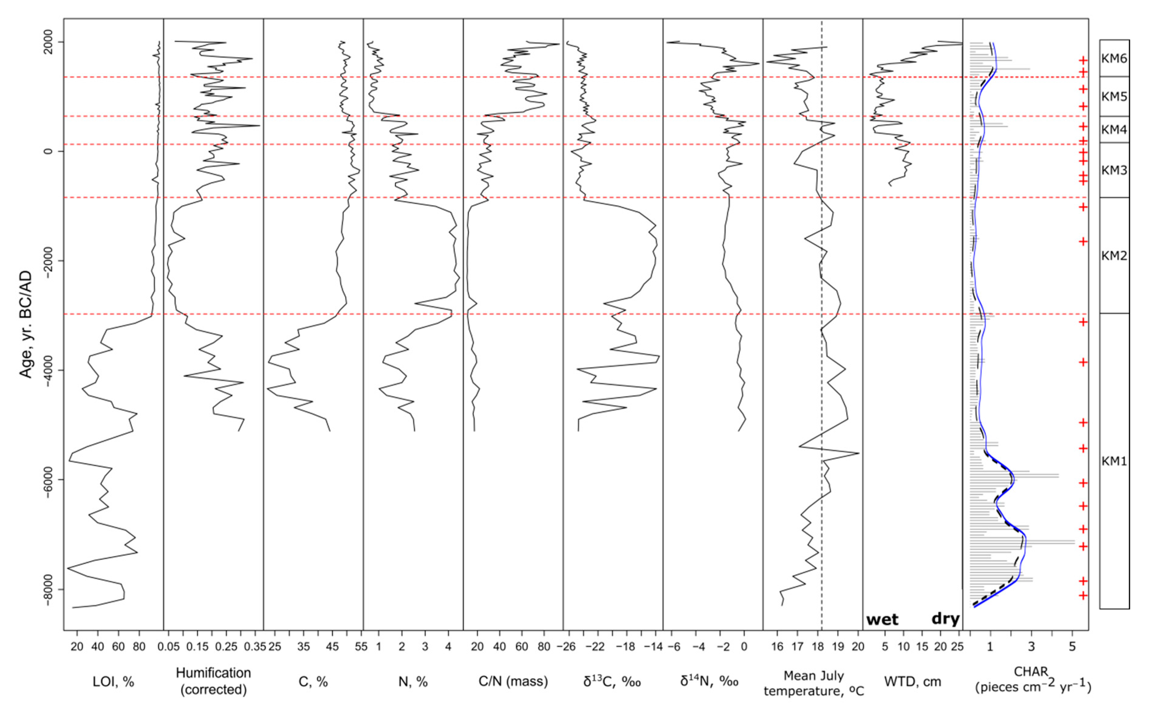
The obtained biostratigraphic data were visualized with the R packages “rioja” [56] and “analog” [57] in the R language environment [42]. The main developmental stages of the mire were visually delimited based on the plant macrofossil composition of the peat deposits (Table S1). These stages were used for the description of other proxies because vegetation composition is one of the major determinants of successional changes in ecosystems. Besides, an application of statistical zonation approaches to the range of the proxies used in this study might have resulted in a number of poorly related boundaries.

3. Results

3.1. Chronology and Biostratigraphy

The results of radiocarbon dating and the age-depth model are presented in Table 1 and Figure 2. The age of the bottom layers of the deposits can be estimated as 8330 BC. Overall, based on the deposit sedimentation times, two main periods could be distinguished: the 1st period (8330–840 BC) of lake-early fen deposits was characterized by relatively slow accumulation (sedimentation time: 25.8 yr cm−1) and the 2nd period (840 BC–present) of faster accumulating fen-bog deposits (sedimentation time: 7.0 yr cm−1) (Figure 3). Six main developmental stages (KM1–6) of the Krivetskiy Mokh mire were distinguished (Figure 3). The univariate peat properties and reconstructed values of local wetness and air temperature are presented in Figure 4 and Table S2.

3.2. Zone KM1 (700–500 cm; 8330–3000 BC): Lake Stage

Pollen recovered from the lowermost portion (8330–7700 BC) of the peat deposits contained high abundances of Betula and Pinus with some Ulmus (Figure 5, Table S3). The non-arboreal vegetation was represented by Poaceae, Brassicaceae and Rosacea. Reconstructed mean July temperatures (Figure 4) were 0.9–2.2 °C lower than the modern values. Around 7700 BC, the proportion of deciduous trees (Alnus, Ulmus and Tilia) increased largely at the expense of Pinus. The difference in mean July temperatures reduces 0.3–1.1 °C. Since 6800 BC, there was a sharp decrease in Betula associated with increased proportions of other deciduous trees (Alnus, Ulmus, Tilia and Quercus). Later (around 4800 BC), Picea, Pinus and Quercus became constantly present and remained until the end of the zone, whereas the proportion of Betula further decreased. Among non-arboreal pollen, Chenopodiaceae, Rosaceae and Poaceae were occasionally abundant with lower abundance in comparison to the beginning of the zone that indicates minimal areas of open landscapes. Reconstructed mean July temperatures exceeded the modern values by 0.1–1.8 °C during most of the zone (6500–3700 BC; with a single cooling event around 5400 BC) and dropped to the modern values by the end of the zone (3800–3000 BC). Plant macrofossils (Figure 6) were dominated by typical water plants (Nymphaea alba, Najas marina, Najas flexilis and Characeae). Starting from 5100 BC, the proportion of the organic material in the deposits varied from 20 to 80% with a stable C:N ratio ca. 20 (Figure 3 and Figure 4). Delta (δ) 13C of the deposits fluctuated considerably, and the absolute values of δ15N remained constantly high (Figure 3 and Figure 4). Peat humification ranged from 0.29–0.31 in 5100 BC to 0.10–0.11 in 3000 BC (Figure 3 and Figure 4). Cladocera remains (Figure 7, Table S4) were abundant and formed mainly by Acroperus harpae and Chydorus sphaericus, which indicate the presence of developed littoral vegetation. The presence of Bosmina longirostris indicates a developed pelagic environment. In contrast, testate amoebae (Figure 8, Table S5) were few and represented mostly by aquatic species (Centropyxis aculeata forms and Difflugia globulosa), whereas diatoms were almost absent (Figure 9, Table S6). Macrocharcoal analysis shows (Figure 3 and Figure 4, Table S7) that during 8330–5700 BC, charcoal accumulation rates were relatively high, reaching 5 pieces cm−2 yr−1. Background charcoal accumulation rate varied from 1 to 3 pieces cm−2 yr−1. Six local fire episodes (i.e., fires that occurred a few kilometers from the mire) were identified (one episode per less than 500 yr). The episodes were distributed relatively evenly. The remaining period (5700–3000 BC) is characterized by background macro charcoal accumulation rate >1 piece cm−2 yr−1 and had four local forest fire episodes. However, the frequency of local fire episodes was relatively low (approximately one episode per less than 900 yr).

3.3. Zone KM2 (500–410 cm, 3000–840 BC): Early Stages of Terrestrialization

The proportion of Betula, Tilia and Ulmus in the regional vegetation decreased in favor of Picea, Pinus and Alnus, with a peak of Picea around 2000 BC. By the end of the zone (1400–840 BC), the abundance of Picea and Pinus declined with a corresponding rise of Betula and Alnus as well as herbaceous taxa, i.e., Artemisia, Thalictrum, Chenopodiaceae and Poaceae (Figure 5). Reconstructed mean July temperatures (Figure 4) were 0.6–0.8 °C greater than the present-day values during 3000–2550 BC and then decreased and fluctuated around them for the rest of the period. Plant macrofossil remains were dominated by the Potamogeton and Nymphaea, indicating active vegetation growth in the lake (Figure 6). Fen species Menyanthes trifoliata and poor-fen species Andromeda polifolia were also present. The organic matter content increased to 90% or greater (Figure 3 and Figure 4), which was associated with higher concentrations of carbon and nitrogen. However, C:N ratio remained stable (Figure 3 and Figure 4). Delta δ13C values were generally high, being lower at the beginning and the end of the zone, whereas the of δ15N values decreased as compared to the previous zone with patterns opposite to those of δ13C, i.e., being greater at the beginning and the end of the zone (Figure 3 and Figure 4). Peat humification was low (0.04–0.10), indicating a minimal degree of organic matter decomposition and slightly increased by the end of the zone (Figure 3 and Figure 4). Among Cladocera remains, the proportion of Chydorus sphaericus reached a maximum, pointing to developed macrophyte vegetation. However, the presence of Bosmina longirostris still shows the existence of an open water environment (Figure 7). Testate amoebae became more abundant and were dominated by freshwater taxa, although some Sphagnum-dwelling species (Archerella flavum and Hyalosphenia papilio) appeared (Figure 8). Diatoms became more abundant and were represented by paludal (Eunotia paludosa and Eunotia bilunaris), epiphytic (Cocconeis placentula) or ubiquitic (Lutticola mutica) taxa (Figure 8). The end of the zone is characterized by the appearance of a planktonic taxon Aulacoseira ambigua typical for eutrophic water bodies and streams that might indicate the presence of patches of open water. Macrocharcoal accumulation rate (Figure 3 and Figure 4) was lowest for the entire core and did not exceed 0.5 pieces cm−2 yr−1. Two local fire episodes were allocated (i.e., more than one episode for 1000 yr).

3.4. Zone KM3 (410–330 cm, 840 BC–130 AD): Fen Stage

The proportion of Betula and Alnus increased, whereas most of the other deciduous trees (Tilia, Quercus and Ulmus) reduced their abundance. The abundance of Picea and Pinus greatly varied. The zone is marked by an increased proportion of Artemisia and Plantago, and other herbs (Figure 5). Reconstructed mean July temperatures (Figure 4) varied around the modern values for the beginning of the zone (840–350 BC) and later decreased to 16.8–17.8 °C. Plant macrofossils were dominated by brown mosses Pseudocalliergon trifarium, Meesia triquetra, Hamatocaulis sp., Drepanocladus sp. as well as remains of Carex sp., Cyperaceae and herb rootlets (Figure 6). C:N ratio increased to 30 due to a decline in nitrogen concentration (Figure 3 and Figure 4). Delta (δ) 13C values considerably decreased in comparison with the previous zone, whereas the absolute values of δ15N became slightly more variable. Peat humification fluctuated (Figure 3 and Figure 4), being at maximum during 580–520 BC and in 230 BC and at a minimum during 790–710 BC, 350 BC and 170 BC. Cladocera remains became less abundant (Figure 7) and were dominated by macrophyte/sediment-associated Alona rectangula and macrophyte associated Alonella excisa, whereas pelagic species disappeared. Testate amoeba assemblages were formed by a mixture of aquatic (Centropyxis aculeata) and moss-dwelling (Hyalosphenia papilio and Nebela collaris) taxa with the prevalence of aquatic forms (Figure 8). Reconstructed WTD shows quite stable moderately wet conditions during the zone (Figure 4). Diversity of diatoms increased and included eutrophic (Aulacoseira ambigua), paludal (Eunotia paludosa and Eunotia nymanniana), and at the same time acidophilic (Kobayasiella subtilissima) and even pelagic (Aulacoseira granulata and Cyclostephanos dubius) indicators (Figure 9). Both testate amoebae and diatoms show high spatial or temporal heterogeneity of the ecosystem. Macrocharcoal accumulation rate (Figure 3 and Figure 4) slightly increased but remained relatively low and did not exceed 0.65 pieces cm−2 yr−1. In total, four fire episodes were identified, i.e., approximately one fire episode for 250 yr.

3.5. Zone KM4 (330–250 cm, 130–640 AD): Early Bog Stage

The zone is characterized by an increased proportion of spores, especially Equisetum and Sphagnum, as well as the pollen of Menyanthes trifoliata and Cyperaceae that indicate the development of the mire (Figure 5). The proportion of Betula decreased, whereas most of the other trees became more abundant (Picea, Pinus and Quercus). However, at the end of the zone, the latter sharply decreased with a simultaneous increase in the proportion of Alnus. Among herbs, Artemisia, Plantago, Poaceae and Brassicaceae were constantly presented throughout the zone (Figure 5). Reconstructed mean July temperatures (Figure 4) were about 18.1–18.8 °C during 130–550 AD, then decreased to 17.5–17.6 °C. The plant remains were dominated by Sphagnum angustifolium, Cyperaceae rootlets and Scheuchzeria palustris, indicating a form of relatively dense floating vegetation mat (Figure 6). As in the previous zone, C:N ratios remained around 30 like (Figure 3 and Figure 4). Delta (δ) 13C and δ15N values kept fluctuating as in the previous zone with the maximal values in 350 and 500 AD. Peat humification was highly variable (Figure 3 and Figure 4) with the periods of higher decomposition in 470 AD and lower ones during 340–370 AD and 560–640 AD. Only a few Cladocera remains of Alonella excisa (mostly macrophyte associated) were observed (Figure 7), which reflects highly reduced areas of aquatic habitats. Testate amoeba assemblages were dominated by moss-dwelling Hyalosphenia papilio and Archerella flavum with lower abundances of aquatic Centropyxis aculeata (Figure 8). Reconstructed WTDs show high variability within the zone (Figure 4) that probably reflects fluctuation of aquatic and moss habitats spread within the peatland. Diatom assemblages represented a mixture of paludal (Eunotia paludosa, Eunotia bilunaris, Eunotia bilunaris var. mucophila and Kobayasiella subtilissima), planktonic (Aulacoseira ambigua and Aulacoseira granulata) and epiphytic (Cocconeis placentula, Epithemia adnata and Fragilaria venter var. venter) taxa (Figure 9). Besides, paludal taxa Nitzschia amphibian and Hantzschia amphioxys, which are able to survive dry periods, were also present. The macro charcoal analysis (Figure 3 and Figure 4) shows an increase in both background and interpolated charcoal accumulation rates up to 0.8 and 2 pieces cm−2 yr−1, respectively. Two local forest fire episodes were indefinite for this period (one fire every about 250 yr).

3.6. Zone KM5 (250–120 cm, 640–1350 AD): Wet Bog Stage

In the regional vegetation, the proportion of Picea and Pinus sharply increased, whereas most of the other trees became less abundant (except for Betula) (Figure 5). From the middle of the zone (around 1050 AD), the proportion of Ericales increased. Reconstructed mean July temperatures (Figure 4) were about 16.9–17.6 °C during 640–1300 AD (0.7–1.4 °C lower than modern values). The local vegetation was mostly formed by Sphagnum magellanicum (Figure 6). C:N ratios increased to 60 due to a decline in nitrogen concentration (Figure 3 and Figure 4). Delta δ13C values were steadily low, whereas δ15N remained low but with three peaks in 960, 1130 and 1300 AD (Figure 3 and Figure 4). Peat humification fluctuated (Figure 3 and Figure 4) with periods of higher decomposition during 940–970 AD and 1270–1300 AD and a lower one during 770–830 AD. Cladocera remains were not observed starting from this zone (Figure 7). Testate amoeba assemblages were dominated by moss-dwelling taxa (Hyalosphenia papilio, Archerella flavum and Cryptodifflugia sacculus) living in moderately wet conditions (Figure 8). Testate amoeba-based WTD reconstruction shows the persistence of wet habitats through the zone (Figure 4). Diatom abundance increased mainly due to planktonic (Aulacoseira ambigua, Aulacoseira granulata, Cyclotella meneghiniana and Stephanodiscus alpinus) and paludal (Eunotia paludosa, Eunotia bilunaris and Eunotia bilunaris var. mucophila) taxa together with several ubiquitous (Nitzschia amphibian and Hantzschia amphioxys) and epiphytic (Cocconeis placentula) taxa (Figure 9). The background accumulation rate of macro charcoal (Figure 3 and Figure 4) slightly decreased to 0.5–0.7 pieces cm−2 yr−1. Two local forest fire episodes were detected with an approximate frequency of one fire episode per 350 yr.

3.7. Zone KM6 (120–0 cm, 1350–2018 AD): Dry Bog Stage

The proportion of non-arboreal pollen (Artemisia, Rumex, Poaceae and Chenopodiaceae) steadily increased, indicating the reduced forest cover in the region. Picea and Pinus, as well as broadleaved trees (Quercus and Ulmus), decreased, whereas the abundance of Alnus and Ericales rose (Figure 5). Reconstructed mean July temperatures (Figure 4) were about 15.8–17.5 °C during 1460–1855 AD, which is lower than modern values by 0.8–2.5 °C with minimal values during 1640–1750 AD. The local vegetation was dominated by Sphagnum fuscum (Figure 6). Pinus and Betula remains were also detected at the end of the zone (Figure 6) that indicates peatland forestation. C:N ratios remained around 60, as in the previous zone (Figure 3 and Figure 4). Values of δ13C were low, decreasing to the top and reaching the minimum, whereas δ15N values sharply increased in 1574 AD and declined towards the surface after that (Figure 3 and Figure 4). Peat humification fluctuated (Figure 3 and Figure 4) with periods of greater decomposition during 1630–1690 AD and lower during 1370–1410 AD and 1880–1905 AD reaching minimal values at the surface. Xerophilic testate amoebae (Assulina muscorum and Trinema lineare) dominated at this stage (Figure 8). Reconstructed WTD steadily decreased upwards, being the driest over the entire period of peatland development (Figure 4). The proportion of aquatic taxa in diatom assemblages greatly declined, and they were mostly formed by paludal (Eunotia paludosa, Eunotia bilunaris, Eunotia bilunaris var. mucophila and Eunotia nymanniana) and ubiquitous (Hantzschia amphioxys) taxa (Figure 9). The background accumulation rate of macro charcoal (Figure 3 and Figure 4) slightly increased to 1.2 pieces cm−2 yr−1 at the beginning of this period. The interpolated CHAR values were almost 3 pieces cm−2 yr−1. After 1700 AD macro charcoal accumulation rate had a minor downward trend. Two local forest fire episodes were identified at the beginning of this stage.

4. Discussion

The results obtained in this study provide a long-term reconstruction of mire development, regional vegetation, climate dynamics and human impact for the border between mixed and boreal forest in the East European Plain during most of the Holocene. The reconstructed mire development covers the entire sequence, including a long-lasting lake stage, fen dominated by green and brown mosses and Sphagnum-dominated oligotrophic bog. That allows us to describe the classic hydroserial succession [5,27,33,34] using not only plant macrofossils but other indicators such as testate amoebae, 13C and 15N isotopes, cladocerans and diatoms. To set the mire development in a more general context, we used pollen (to reconstruct regional vegetation, climate and human impact) and macro charcoal (to reconstruct local fire regime) and interpreted the results within the frameworks of the classical “Blytt-Sernander” system modified for the East European Plain by Khotinsky [65]. Overall, the reconstruction is based on a number of proxies that improve its reliability by providing data from several relatively independent proxies.

4.1. Regional Vegetation, Fire Regime and Climate Reconstruction

4.1.1. Boreal Stage (8300–6800 BC)

Our pollen data (Figure 5) indicate that during 8300–7700 BC, the region was occupied by pine-birch forests with some elm-trees. Other studies [32] also show that during the Boreal stage, with its cold and relatively dry climate, the study area was covered by birch forests with Betula pubescens as principal arboreal species as well as Betula nana and Betula humilis. In the adjacent Priil’men Lowlands between 8000–6000 BC, the landscapes were covered by mixed forests with pine and birch [34]. Probably, the dominance of post-pyrogenic pine-birch forests and the low occurrence of broadleaved species is the result of the high frequency of forest fires noted at that period in the boreo-nemoral zone [66]. Subsequently, the proportion of broadleaved trees (Alnus, Ulmus and Tilia) increased alongside the depletion of Pinus, whereas non-arboreal vegetation reduced their distribution in comparison to the initial period (8300–7700 BC) that indicate minimal areas of open landscapes. The periglacial vegetation complex gradually degraded throughout the early Holocene. Open landscapes decreased significantly from 7800 until 7000 BC when the percentages of Artemisia and Chenopodiaceae pollen reached low values, typical for wooded landscapes [34]. Our pollen-based temperature reconstruction (Figure 3) suggests that mean July temperatures were 0.9–2.2 °C lower than the modern values and then the difference gradually decreased to 0.3–1.1 °C by 6800 BC.

4.1.2. Atlantic Stage (6800–3700 BC)

In the Early Atlantic (6800–5500 BC), the role of Betula, Corylus, Ulmus and Tilia increased (Figure 5), reflecting the transition from the early Holocene to the maximum thermal conditions [34]. The period of decreased charcoal accumulation rate is correlated with the greater role of broadleaved trees and the reduced pine proportion in the forests. A similar situation is observed in other regions of the central part of the East European Plain, which are characterized by a predominance of sandy soils and pine forests [67,68]. Our pollen-based temperature reconstruction (Figure 3) suggests that mean July temperatures were 1.0–1.5 °C lower than modern levels between 6800–6500 BC and then the difference in temperatures reduced to 0.2–0.5 °C between 6500–5600 BC.
In the Late Atlantic (5500–3700 BC), the study region was covered by the vegetation by various types of broadleaved and mixed coniferous-broadleaved forests [34]. Forests composed of Betula, Alnus, Quercus, Ulmus and Corylus with rare Picea and Pinus (Figure 5), which grew on mires and water-logged sites around them [69]. These observations are in agreement with previous works that suggest that the Atlantic stage was characterized by maximal heat supply and optimal temperature and precipitation conditions over the entire territory of Northern Eurasia [69]. Among non-arboreal pollen, Artemisia, Chenopodiaceae, Brassicaceae, Rosaceae and Poaceae were occasionally abundant (Figure 4) that might reflect possible human impact. Our pollen-based temperature reconstruction (Figure 3) suggests that mean July temperatures during 5500–3700 BC exceeded modern values by 0.4–1.8 °C. This is in line with the previously published climate reconstruction based on the pollen data from Staroselsky Moch peatland (the southern Valdai Uplands; [70]), which reported the mean annual temperature in the area was 1–3 °C higher than modern values between 5000 and 3500 BC. The region was widely occupied by Neolithic hunter-fishers-gatherers [39]. However, the proportion of open landscapes was probably minimal during the Holocene [34]. Pollen data from a number of other sites in the East European Plain [71,72,73,74,75] demonstrated a wide distribution of broadleaved forests with Quercus and Ulmus as dominant species during this period. Pollen grains of Picea and Pinus are frequently found in pollen assemblages, but their low abundances indicate their remote location from the study site, which was probably surrounded by broadleaved forests. In contrast, in eastern and northeastern regions of European Russia, the proportion of spruce pollen was greater—up to 5–10% and even 20–30% in Karelia around 5000 BC [76]. The increased precipitation also favored broadleaved species indirectly by suppressing forest fires [77]. Similar patterns were demonstrated by studies in the central and northeastern parts of the East European Plain [67,78].

4.1.3. Subboreal Stage (3700–600 BC)

Our pollen data indicate an increased abundance of Picea and Pinus and a reduced abundance of broadleaved trees that support the previous data on cool and dry climate at the study area during the Subboreal stage [79]. However, the proportion of broadleaved trees in forests remained relatively high in central European Russia, Belarus and the Baltic region during 3700–2000 BC [72,80,81]. The proportion of Picea in the pollen spectra also increased in the Krivetskiy Moch (Figure 5) as well as in other studied areas of the southern part of the Valdai Uplands [69]. Probably it was correlated with the low frequency of forest fires [67]. However, the proportion of Picea macrofossils in the peat profile remained low during this period (Figure 6), suggesting that while spruce was present in the landscape, it was not growing in the immediate vicinity of the studied peatland.
Considerable changes in the vegetation occurred during 2300–1400 BC with increasing abundance of Picea and Pinus and the corresponding decline of deciduous Betula, Tilia, and Ulmus (Figure 5). This is consistent with the observation that, after 2000 BC, Picea reached its maximal range expansion, triggered cooler climate in most sites in Belarus, European Russia, Baltic and NE Poland [71,73,74,78,82]. However, broadleaved trees (Quercus), as well as Corylus and Alnus, persisted in the central part of the East European Plain [32,80]. Nevertheless, at the end of the Subboreal stage (1400–700 BC), there was a decline in the abundance of Picea and Pinus with a corresponding rise of Betula and Alnus as well as herbaceous taxa, i.e., Artemisia, Thalictrum, Chenopodiaceae and Poaceae (Figure 5) that probably reflects the expansion of open landscapes and waterlogged habitats as well as the increased human impact. This period is associated with the spread of the early pastoral tribes to the Valdai Uplands; unfortunately, there is no archaeological evidence of their presence in close vicinity of our study site yet [83].
Our pollen-based temperature reconstruction (Figure 3) suggests that mean July temperatures were 0.8–1.0 °C higher than modern values between 3000 and 2550 BC, and then the temperature dropped down to modern values with some fluctuations between 2100 and 900 BC. Other available climate reconstructions for southern parts of Valdai Uplands based on pollen data [70] showed the first notable cooling at 3000 BC when the mean annual temperature was close to the modern values (4.1 °C). About 2000 BC, the mean annual temperature declined to 3 °C and precipitation increased to 750–800 mm year−1. It seems that low evaporation and relatively high precipitation promoted the rise of Picea in woodlands.

4.1.4. Subatlantic Stage (600 BC–Present)

Our data show that spruce (Figure 5) abundance experienced two declines within the period 600 BC–100 AD, which coincided with increased proportions of Betula and Alnus (and a corresponding decrease in deciduous Tilia, Quercus and Ulmus). At the beginning of the Subatlantic stage, the spruce forest became the main vegetation type in the Eastern Europe Plain [32,76,80,81,82]. After 600 BC, coniferous forests spread from the Valdai Uplands and the northeastern part of European Russia to the central regions [69]. Besides, our pollen record suggests the rise of herbaceous plants, such as Artemisia and Plantago (Figure 5), that may be related to cooling and indicate human impact and development of arable land [34]. Indirect support of possible human influence on a local scale provides evidence of stable spruce abundance in the southern part of the Valdai Uplands [69]. The decreased proportion of broadleaved trees coincides with an increased concentration of macro charcoal. This might indicate a greater impact of forest fires or anthropogenic burning on ecosystems that corresponds to the results of some previous studies for the central part of the East European Plain [68,77,78] and Fennoscandia [21]. During this period, Early Iron Age Djakovskaya archaeological culture (800 BC–600 AD) was present in the region [39]. Local archaeological sites mark the demographic rise and agricultural activity of the population.
Starting from 100 AD (Figure 5), the abundance of plant species that prefer wet conditions (Equisetum, Menyanthes trifoliata and Cyperaceae) increased, which might indicate wetlands expansion, as it was also shown for the southern Valdai Uplands [69]. A sharp decrease in the abundance of Picea and an increase in the proportion of Alnus at 510–570 AD (Figure 5) may indicate paludification of the spruce forest [69]. The archaeological culture of the long barrows was distributed in the region since the middle of the first millennia AD. Archaeological layers of these sites include pollen of cultural cereals [84]. The increased distribution of Alnus may indicate slash-and-burn or shifting farming systems, during and after which many abandoned lands appeared. Gray alder (Alnus incana) successfully occupied such areas [84].
Since 630 AD (Figure 5) in the regional vegetation, the proportions of Picea and Pinus sharply increased, whereas most of the other trees (especially Alnus) became less abundant (except for Betula). Sharp declines in spruce and pine were detected in 1300 AD with a corresponding rise of birch and alder (Figure 5). From 1350 AD, the proportion of non-arboreal pollen (Artemisia, Rumex, Poaceae and Chenopodiaceae) steadily increased, indicating the reduced forest cover in the region and arable area expansion. The decline of Picea and Pinus, as well as broadleaved trees with the corresponding rise of Alnus and Ericales, reflect further paludification of the region.
Pollen records from lakes and peatlands throughout Europe show signs of human impact on vegetation starting from the mid-Holocene [85]. The sharp increase in micro-charcoal accumulation rate and the reduced proportion of Picea and broadleaved trees reported for the southern Valdai Uplands [69] coincided with the expansion of Betula. From ca 1600 AD, the plant communities in the region featured various taxa indicative of anthropogenic disturbance, erosion and grasslands [69], including Centaurea cyanus, Plantago, Artemisia, Chenopodiaceae, Asteroideae, Cichorioideae, Rubiaceae, and Poaceae. However, in our study area, no diverse anthropogenic indicators were detected, and there were no cereals found in both territories that indicate the low intensity of land use in the region. A large decline in the population and economic activity in this area can be expected between the 16th and 18th centuries due to cooling (see below). Perhaps, a small number of the above-mentioned indicators of anthropogenic impact are due to the fact that the studied bog is located far from historical villages of Iron Age sites [86]. The nearest Medieval burial site (9–13 AD centuries) is situated one kilometer from the mire [87].
Our pollen-based temperature reconstruction (Figure 3) also exhibits fluctuations within the period with the corresponding temperatures equal to modern levels (900–350 BC; 100–500 AD) and periods with lower temperatures compared to modern ones (250 BC–100 AD; 630–1855 AD) with minimal values (2.4–2.6 °C lower than today) between 1638 and 1754 AD, coincided with so-called ‘Little Ice Age’ period. Climate reconstructions for the period from 600 BC to the present based on pollen data from Staroselsky Moch peat bog [70] showed large variations in temperature and precipitation. At the beginning of this period, the mean annual temperature and precipitation were close to modern values. Then, during the period of 500 BC–400 AD, the temperature slightly increased to 4.5–5.0 °C, whereas precipitation remained around 700 mm yr–1.

4.2. Peatland Development

4.2.1. Lake and Early Stages of Terrestrialization (8300–900 BC)

The first plant species that colonized the water body (7000–3000 BC) were Najas marina, Najas flexilis, Nymphaea alba and Characeae (Figure 6) that indicate low to medium nutrient-rich water. Both N. flexilis and N. marina are thermophilous submerged plants, the remains of which are commonly found as macrofossils in deposits accumulated during Holocene Thermal Optimum in the northern hemisphere [88,89]. The almost simultaneous decline of these plant populations may have been caused by changes in environmental conditions, e.g., acidification as well as climate deterioration (cf. Gałka et al. [89] and the papers cited there). On the other hand, the disappearance of Najas is followed by the development of the Potamogeton pusillus population. Probably, competition between these species may also be considered as a major mechanism of ecosystem dynamics. However, the simultaneous occurrence of P. pusillus and N. flexilis was previously recorded in sediments in NE Poland [89] and in modern vegetation of Polish lakes [90]. Loss on ignition data shows high fluctuations during this time but exhibits a rapid increase to reach values typical of ombrotrophic bogs (i.e., greater than 90%) by 3000 BC. The C and N values were low, and the C:N ratio varied between 10 and 20 (Figure 4), which indicates a mostly autochthonous origin of nutrients in the lake [91]. Isotopic composition of C (δ13C values) sharply fluctuated, likely reflecting the different contributions of Characeae in the sediments [92,93]. The next period (3000–900 BC) is marked by the presence of Potamogeton pusillus and Nymphaea alba as well as fen species Menyanthes trifoliata and poor-fen species Andromeda polifolia (Figure 6), indicating active vegetation growth in the lake, probably stimulated by an increase in the content of organic matter at the bottom [94]. The concentration of C and N increased, but C:N ratio remained less than 20 (Figure 3), which shows a mostly autochthonous origin of nutrients [91].
Cladocera remains were abundant and formed mainly by Acroperus harpae and Chydorus sphaericus, which indicate the presence of developed littoral vegetation and Bosmina longirostris that reflect a pelagic environment [95]. Testate amoebae remains were few and represented mostly by aquatic species (Centropyxis aculeata and Difflugia globulosa) and those living in acidic wetlands (Hyalosphenia papilio and Archerella flavum), which is probably explained by unfavorable conditions for shell preservation. Diatoms were also rare but indicated acidic conditions. The absence of diatoms in lacustrine sediments was earlier reported [96,97]. Several taphonomic processes such as removal from the outflow of lakes, the resuspension and reworking of older sediments, losses due to grazing, bioturbation and dissolution may negatively affect diatom preservation in sediments [98].

4.2.2. Fen and Early Stages of Ombrotrophication (900 BC–640 AD)

Starting from 900 BC, brown mosses Pseudocalliergon trifarium, Meesia triquetra, Hamatocaulis sp. and Drepanocladus sp. prevail in peat macrofossils composition (Figure 6) that indicate minerotrophic conditions common for extremely or moderately rich fens [91]. Moreover, macrofossils of those mosses are found quite often in peat deposited in the transitional stage between rich fen and bog [30,88,99]. From 100 AD, Sphagnum angustifolium and Scheuchzeria palustris appeared along with brown mosses (Figure 6), indicating the formation of a relatively dense floating vegetation mat with areas of ombrotrophication and subsequent acidification. Moreover, the presence of Carex sp., Cyperaceae rootlets and other herbs rootlets, as typical pioneering mat-forming plants, may indicate a classical lateral (centripetal) encroachment of original vegetation mats from the margins of the lake [1,7]. The C:N ratio fluctuated around 30 during the entire stage (Figure 3) due to a sharp decrease in nitrogen input that indicates the onset of oligotrophication. Cladocera remains became less abundant (Figure 7) and were dominated by macrophyte/sediment-associated Alona rectangula and macrophyte associated Alonella excisa, whereas pelagic species disappeared. Changes in the ratio of pelagic/macrophyte-associated Cladocera is known as an indicator of lake water level, macrophyte development and nutrients availability [95,100]. Testate amoeba assemblages represent a mixture of aquatic (Centropyxis aculeata) and moss-dwelling (Hyalosphenia papilio, Nebela collaris and Archerella flavum) taxa with gradual declining of aquatic forms during this period (Figure 8). Both testate amoebae and diatoms indicate high spatial heterogeneity within the ecosystem or temporal variability at decadal–century scale. Overall, the results suggest that inputs of mineral material declined as the peatland developed but considerably depleted levels were achieved even though the vegetation was still that of a fen [27].

4.2.3. Bog (640 AD–until Present)

At 640 AD, the ecosystem underwent a rapid shift to the bog community. In addition to the establishment of ombrotrophic (Sphagnum magellanicum and Sphagnum fuscum) and loss of minerotrophic (brown mosses) species, other characteristic taxa (Eriophorum vaginatum and Oxycoccus palustre) were detected in plant macrofossils that could be taken as indicating a ‘dry fen-to-bog transition’ with the change initiated by decreased water tables decoupling the peat surface from groundwater supply [101]. Once established, Sphagnum mosses change the ecosystem to their advantage by acidifying the habitat and creating water-logged, nutrient-poor environments that impede other species [102]. The appearance of E. vaginatum further assists the ombrotrophication process [103] as it was shown to act as an ‘ecosystem engineer’ that changes the habitat conditions in a way they are more suitable for the establishment of oligotrophic-ombrotrophic Sphagnum mosses [104]. The highly resistant remains of E. vaginatum promote peat accumulation and consequent ombrotrophication [105].
Overall, it took ca. 500 years from the first appearance of Sphagnum (S. angustifolium) in the mire (which coincided with climate warming) at 100 AD until the total prevalence of Sphagnum (as S. magellanicum carpet) at 640 AD (and coincided with climate cooling). In 1350 AD, i.e., approximately in 700 years, the ecosystem shifted to a drier peatland covered by Sphagnum fuscum. The transitions between these periods were relatively rapid (i.e., decades), supporting the idea for the non-linear, step-like behavior of peatland ecosystems at this stage [7]. Testate amoeba and diatom assemblages were characterized by greater roles of xerophilic taxa (Figure 8 and Figure 9), especially in the final stage of peatland development when reconstructed water table depths were minimal (Figure 4). The appearance of pine and birch on the peatland surface as indicated by the macrofossils remains (Figure 2) suggests a forestation of the mire surface. Most likely, since 1350 AD, peatland represented a mixture of drier (with S. fuscum hummocks during 1350–1460 AD and 1750 until the present) and wetter (with S. magellanicum lawns during 1460–1750 AD) habitats. Probably these dynamics might be related to possible fires and climatic shifts.

5. Conclusions

The studied lake-mire deposits were accumulated over most of the Holocene (starting from the early Boreal stage) and represented a classical progressive succession of a lake ecosystem towards a mire with reduced water saturation and increasing acidity. The applied multi-proxy approach allowed us to estimate changes in the diversity of local vegetation, testate amoebae, cladocerans and diatoms and relate it to environmental and climate changes as well as human impact reconstructed with pollen, macro charcoal and physical peat properties. The studied ecosystem transitioned through the following main stages: a long-lasting lake stage (8300–900 BC), fen (900 BC–630 AD) and ombrotrophic bog (630 AD–present). These periods correspond well with the human colonization of the area; however, anthropogenic activity and peatland development might be both related to climate. Human impact on the mire development might by the most clearly manifested during 900 BC–630 AD when the numerous agricultural communities spread in this area that could lead to changes in the water regime on the watershed. Each stage was associated with clear changes in local diversity of organisms responding mostly to autogenic successional changes during the lake stage and to allogenic factors at the fen-bog stage. It took ca. 500 years from the first appearance of Sphagnum (S. angustifolium) in the mire (which coincided with climate warming) at 100 AD until the total prevalence of Sphagnum (as S. magellanicum carpet) at 640 AD (and coincided with climate cooling). Since 1350 AD, the peatland represented a mixture of drier (with S. fuscum hummocks) and wetter (with S. magellanicum lawns) habitats. Probably these dynamics might be related to possible fires and climatic shifts. Overall, the lake-mire successions did not result in increased local diversity per se but might significantly contribute to greater regional diversity by creating a more heterogeneous environment.

Supplementary Materials

The following are available online at https://0-www-mdpi-com.brum.beds.ac.uk/1424-2818/12/12/462/s1. Table S1: The results of plant macrofossil analysis, Table S2: Loss on ignition (%), peat humification (measured as light absorbance), C (%), N (%), δ13C (‰), δ15N (‰) and reconstructed WTD, Table S3: The results of pollen analysis, Table S4: The results of Cladocera analysis, Table S5: The results of testate amoeba analysis, Table S6: The results of diatom analysis, Table S7: The results of the macro charcoal analysis.

Author Contributions

Conceptualization, A.V.T., M.V.D. and Y.A.M.; project administration, A.V.T..; fieldwork, Y.A.M., A.N.T., M.V.B., D.A.K., K.V.B., M.V.D. and A.V.T.; pollen and LOI analyses, N.G.M.; plant macrofossils analysis, M.G. and N.G.M.; testate amoeba analysis, A.A.K., A.D.M. and D.A.S.; charcoal analysis and interpretation, M.V.B. and D.A.K.; diatom analysis, D.V.R. and K.P.K.; Cladocera analysis, T.G.S. and Y.A.P.; peat humification analysis, Y.A.F.; C, N and stable isotopes analyses, A.V.T.; radiocarbon dating, E.P.Z.; archaeological background and interpretations, M.V.D.; data curation, analysis and visualization, A.N.T; Y.A.M. wrote the first draft of the manuscript to which all authors contributed with text, comments and ideas. All authors have read and agreed to the published version of the manuscript.

Funding

This research was funded by the Russian Foundation for Basic Research (grant number 18-00-00819) and the Russian Science Foundation (grant number 19-14-00102—testate amoeba and diatom analyses).

Acknowledgments

We are grateful to Georgy Lekarev for his help in fieldwork, support and hospitality.

Conflicts of Interest

The authors declare no conflict of interest. The funders had no role in the design of the study; in the collection, analyses, or interpretation of data; in the writing of the manuscript, or in the decision to publish the results.

References

  1. Rydin, H.; Jeglum, J.K.; Bennett, K.D. The Biology of Peatlands, 2nd ed.; Oxford University Press: Oxford, UK, 2013. [Google Scholar]
  2. Minayeva, T.; Bragg, O.; Sirin, A. Peatland biodiversity and its restoration. In Peatland Restoration and Ecosystem Services: Science, Policy and Practice; Cambridge University Press: Cambridge, UK, 2016; pp. 44–62. [Google Scholar]
  3. Yu, Z.; Loisel, J.; Brosseau, D.P.; Beilman, D.W.; Hunt, S.J. Global peatland dynamics since the Last Glacial Maximum. Geophys. Res. Lett. 2010, 37, L13402. [Google Scholar] [CrossRef]
  4. Kuhry, P.; Turunen, J. The postglacial development of boreal and subarctic peatlands. In Boreal Peatland Ecosystems; Springer: Berlin/Heidelberg, Germany, 2006; pp. 25–46. [Google Scholar]
  5. Klinger, L.F. The myth of the classic hydrosere model of bog succession. Arct. Alp. Res. 1996, 28, 1–9. [Google Scholar] [CrossRef] [Green Version]
  6. Charman, D. Peatlands and Environmental Change; John Wiley & Sons Ltd.: Hoboken, NJ, USA, 2002. [Google Scholar]
  7. Tsyganov, A.N.; Kupriyanov, D.A.; Babeshko, K.V.; Borisova, T.V.; Chernyshov, V.A.; Volkova, E.M.; Chekova, D.A.; Mazei, Y.A.; Novenko, E.Y. Autogenic and allogenic factors affecting development of a floating Sphagnum-dominated peat mat in a karst pond basin. Holocene 2019, 29, 120–129. [Google Scholar] [CrossRef]
  8. Gearey, B.; Fyfe, R. Peatlands as knowledge archives. In Peatland Restoration and Ecosystem Services: Science, Policy and Practice; Bonn, A., Allott, T., Evans, M., Joosten, H., Stoneman, R., Eds.; Ecological Reviews; Cambridge University Press: Cambridge, UK, 2016; pp. 95–113. [Google Scholar] [CrossRef]
  9. Charman, D.J.; Beilman, D.W.; Blaauw, M.; Booth, R.K.; Brewer, S.; Chambers, F.M.; Christen, J.A.; Gallego-Sala, A.; Harrison, S.P.; Hughes, P.D.M.; et al. Climate-related changes in peatland carbon accumulation during the last millennium. Biogeosciences 2013, 10, 929–944. [Google Scholar] [CrossRef] [Green Version]
  10. McClymont, E.; Pendall, E.; Nichols, J. Stable isotopes and organic geochemistry in peat: Tools to investigate past hydrology, temperature and biogeochemistry. PAGES News 2010, 18, 15–18. [Google Scholar] [CrossRef] [Green Version]
  11. Loisel, J.; Garneau, M.; Hélie, J.-F. Sphagnum δ13C values as indicators of palaeohydrological changes in a peat bog. Holocene 2010, 20, 285–291. [Google Scholar] [CrossRef]
  12. Blackford, J. Palaeoclimatic records from peat bogs. Trends Ecol. Evol. 2000, 15, 193–198. [Google Scholar] [CrossRef]
  13. Barber, K.E.; Chambers, F.M.; Maddy, D. Holocene palaeoclimates from peat stratigraphy: Macrofossil proxy climate records from three oceanic raised bogs in England and Ireland. Quat. Sci. Rev. 2003, 22, 521–539. [Google Scholar] [CrossRef]
  14. Mauquoy, D.; Hughes, P.; Geel, B.V. A protocol for plant macrofossil analysis of peat deposits. Mires Peat 2010, 7, 1–5. [Google Scholar]
  15. Payne, R.; Blackford, J. Peat humification and climate change: A multi-site comparison from mires in south-east Alaska. Mires Peat 2008, 3, 1–11. [Google Scholar]
  16. Amesbury, M.J.; Swindles, G.T.; Bobrov, A.; Charman, D.J.; Holden, J.; Lamentowicz, M.; Mallon, G.; Mazei, Y.; Mitchell, E.A.D.; Payne, R.J.; et al. Development of a new pan-European testate amoeba transfer function for reconstructing peatland palaeohydrology. Quat. Sci. Rev. 2016, 152, 132–151. [Google Scholar] [CrossRef] [Green Version]
  17. Swindles, G.T.; Morris, P.J.; Mullan, D.J.; Payne, R.J.; Roland, T.P.; Amesbury, M.J.; Lamentowicz, M.; Turner, T.E.; Gallego-Sala, A.; Sim, T.; et al. Widespread drying of European peatlands in recent centuries. Nat. Geosci. 2019, 12, 922–928. [Google Scholar] [CrossRef]
  18. Novenko, E.Y.; Tsyganov, A.N.; Babeshko, K.V.; Payne, R.J.; Li, J.; Mazei, Y.A.; Olchev, A.V. Climatic moisture conditions in the north-west of the Mid-Russian Upland during the Holocene. Geogr. Environ. Sustain. 2019, 12, 188–202. [Google Scholar] [CrossRef]
  19. Kaufman, D.; McKay, N.; Routson, C.; Erb, M.; Dätwyler, C.; Sommer, P.S.; Heiri, O.; Davis, B. Holocene global mean surface temperature, a multi-method reconstruction approach. Sci. Data 2020, 7, 1–13. [Google Scholar] [CrossRef]
  20. Fyfe, R.; Brück, J.; Johnston, R.; Lewis, H.; Roland, T.; Wickstead, H. Historical context and chronology of Bronze Age land enclosure on Dartmoor, UK. J. Archaeol. Sci. 2008, 35, 2250–2261. [Google Scholar] [CrossRef]
  21. Kasin, I.; Blanck, Y.; Storaunet, K.O.; Rolstad, J.; Ohlson, M. The charcoal record in peat and mineral soil across a boreal landscape and possible linkages to climate change and recent fire history. Holocene 2013, 23, 1052–1065. [Google Scholar] [CrossRef]
  22. Wanner, H.; Beer, J.; Bütikofer, J.; Crowley, T.J.; Cubasch, U.; Flückiger, J.; Goosse, H.; Grosjean, M.; Joos, F.; Kaplan, J.O.; et al. Mid- to Late Holocene climate change: An overview. Quat. Sci. Rev. 2008, 27, 1791–1828. [Google Scholar] [CrossRef]
  23. Mann, M.E.; Zhang, Z.; Rutherford, S.; Bradley, R.S.; Hughes, M.K.; Shindell, D.; Ammann, C.; Faluvegi, G.; Ni, F. Global signatures and dynamical origins of the Little Ice Age and Medieval Climate Anomaly. Science 2009, 326, 1256–1260. [Google Scholar] [CrossRef] [Green Version]
  24. Lappalainen, E. Global Peat Resources; International Peat Society Finland: Jyskae, Finland, 1996; Volume 4. [Google Scholar]
  25. Novenko, E.Y.; Tsyganov, A.N.; Volkova, E.M.E.M.; Babeshko, K.V.; Lavrentiev, N.V.N.V.; Payne, R.J.; Mazei, Y.A.Y.A. The Holocene paleoenvironmental history of central European Russia reconstructed from pollen, plant macrofossil, and testate amoeba analyses of the Klukva peatland, Tula region. Quat. Res. 2015, 83, 459–468. [Google Scholar] [CrossRef]
  26. Novenko, E.Y.; Tsyganov, A.N.N.; Rudenko, O.V.; Volkova, E.V.; Zuyganova, I.S.; Babeshko, K.V.K.V.; Olchev, A.V.; Losbenev, N.I.; Payne, R.J.R.J.; Mazei, Y.A. Mid- and late-Holocene vegetation history, climate and human impact in the forest-steppe ecotone of European Russia: New data and a regional synthesis. Biodivers. Conserv. 2016, 25, 1–20. [Google Scholar] [CrossRef]
  27. Payne, R.J.; Malysheva, E.; Tsyganov, A.; Pampura, T.; Novenko, E.Y.; Volkova, E.; Babeshko, K.; Mazei, Y. A multi-proxy record of Holocene environmental change, peatland development and carbon accumulation from Staroselsky Moch peatland, Russia. Holocene 2016, 26, 314–326. [Google Scholar] [CrossRef]
  28. Sillasoo, U.; Mauquoy, D.; Blundell, A.; Charman, D.; Blaauw, M.; Daniell, J.R.; Toms, P.; Newberry, J.; Chambers, F.M.; Karofeld, E. Peat multi-proxy data from Männikjärve bog as indicators of late Holocene climate changes in Estonia. Boreas 2007, 36, 20–37. [Google Scholar] [CrossRef]
  29. Gałka, M.; Miotk-Szpiganowicz, G.; Marczewska, M.; Barabach, J.; van der Knaap, W.O.; Lamentowicz, M. Palaeoenvironmental changes in Central Europe (NE Poland) during the last 6200 years reconstructed from a high-resolution multi-proxy peat archive. Holocene 2015, 25, 421–434. [Google Scholar] [CrossRef]
  30. Lamentowicz, M.; Gałka, M.; Lamentowicz, Ł.; Obremska, M.; Kühl, N.; Lücke, A.; Jassey, V.E.J. Reconstructing climate change and ombrotrophic bog development during the last 4000 years in northern Poland using biotic proxies, stable isotopes and trait-based approach. Palaeogeogr. Palaeoclimatol. Palaeoecol. 2015, 418, 261–277. [Google Scholar] [CrossRef] [Green Version]
  31. Tuittila, E.-S.; Juutinen, S.; Frolking, S.; Väliranta, M.; Laine, A.M.; Miettinen, A.; Seväkivi, M.-L.; Quillet, A.; Merilä, P. Wetland chronosequence as a model of peatland development: Vegetation succession, peat and carbon accumulation. Holocene 2012, 23, 25–35. [Google Scholar] [CrossRef]
  32. Novenko, E.Y.; Volkova, E.; Nosova, N.; Zuganova, I. Late Glacial and Holocene landscape dynamics in the southern taiga zone of East European Plain according to pollen and macrofossil records from the Central Forest State Reserve (Valdai Hills, Russia). Quat. Int. 2009, 207, 93–103. [Google Scholar] [CrossRef]
  33. Nosova, M.; Severova, E.; Volkova, O. A 6500-year pollen record from the Polistovo-Lovatskaya Mire System (northwest European Russia). Vegetation dynamics and signs of human impact. Grana 2017, 56, 410–423. [Google Scholar] [CrossRef]
  34. Nosova, M.B.; Novenko, E.Y.; Severova, E.E.; Volkova, O.A. Vegetation and climate changes within and around the Polistovo-Lovatskaya mire system (Pskov Oblast, north-western Russia) during the past 10,500 years. Veg. Hist. Archaeobotany 2019, 28, 123–140. [Google Scholar] [CrossRef]
  35. Łuców, D.; Lamentowicz, M.; Obremska, M.; Arkhipova, M.; Kittel, P.; Łokas, E.; Mazurkevich, A.; Mróz, T.; Tjallingii, R.; Słowiński, M. Disturbance and resilience of a Sphagnum peatland in western Russia (Western Dvina Lakeland) during the last 300 years: A multiproxy, high-resolution study. Holocene 2020, 30, 1552–1566. [Google Scholar] [CrossRef]
  36. IUSS Working Group WRB. World Reference Base for Soil Resources 2014, Update 2015: International Soil Classification System for Naming Soils and Creating Legends for Soil Maps; FAO: Rome, Italy, 2015. [Google Scholar]
  37. Sinitsyna, G.V.; Lavrushin, Y.A.; Spiridonova, E.A.; Guskova, Y.G.; Raspopov, O.M.; Iosifidi, A.G. About chronology of archaeological materials and about age of accomodating deposits of multy layer site Baranova Gora in Tver’ oblast’. In Tverskoy Arheologicheskiy Sbornik; TTOM: Tver’, Russia, 2009; Volume 7, pp. 52–70. [Google Scholar]
  38. Timofeyev, V.I. Raskopki neoliticheskikh stoyanok v Kalininskoy oblasti i v Priladozhye. In Arkheologicheskiye Otkrytiya 1973 Goda; Rybakov, B.A., Ed.; Nauka: Moscow, Russia, 1974; p. 81. [Google Scholar]
  39. Kashkin, A.V. Archaeological Map of Russia. Tver’ Region. Part 4: Bologovskiy, Penoskiy, Udomelskiy and Firovskiy Districts; IA RAS: Moscow, Russia, 2012; Volume 4. [Google Scholar]
  40. Reimer, P.J.; Austin, W.E.N.; Bard, E.; Bayliss, A.; Blackwell, P.G.; Bronk Ramsey, C.; Butzin, M.; Cheng, H.; Edwards, R.L.; Friedrich, M.; et al. The IntCal20 Northern Hemisphere Radiocarbon Age Calibration Curve (0–55 cal kBP). Radiocarbon 2020, 62, 725–757. [Google Scholar] [CrossRef]
  41. Blaauw, M. clam: Classical Age-Depth Modelling of Cores from Deposits; R Package Version 2.3.5; R Foundation for Statistical Computing: Vienna, Austria, 2020; Available online: https://CRAN.R-project.org/package=clam (accessed on 24 November 2020).
  42. R Core Team. R: A Language and Environment for Statistical Computing; R Foundation for Statistical Computing: Vienna, Austria, 2020. [Google Scholar]
  43. Blaauw, M.; Christen, J.A. Rbacon: Age-Depth Modelling Using Bayesian Statistics; R Package Version 2.3.5; R Foundation for Statistical Computing: Vienna, Austria, 2020; Available online: https://CRAN.R-project.org/package=rbacon (accessed on 28 October 2020).
  44. Dean, W.E. Determination of carbonate and organic matter in calcareous sediments and sedimentary rocks by loss on ignition; comparison with other methods. J. Sediment. Res. 1974, 44, 242–248. [Google Scholar]
  45. Chambers, F.M.; Beilman, D.W.; Yu, Z. Methods for determining peat humification and for quantifying peat bulk density, organic matter and carbon content for palaeostudies of climate and peatland. Mires Peat 2011, 7, 1–10. [Google Scholar]
  46. Mooney, S.; Tinner, W. The analysis of charcoal in peat and organic sediments. Mires Peat 2011, 7, 1–18. [Google Scholar]
  47. Higuera, P.E.; Peters, M.E.; Brubaker, L.B.; Gavin, D.G. Understanding the origin and analysis of sediment-charcoal records with a simulation model. Quat. Sci. Rev. 2007, 26, 1790–1809. [Google Scholar] [CrossRef]
  48. Smith, A.J.E. The Moss Flora of Britain and Ireland; Cambridge University Press: Cambridge, UK, 2004. [Google Scholar]
  49. Mauquoy, D.; Van Geel, B. Plant macrofossil methods and studies: Mire and peat macros. In Encyclopedia of Quaternary Science; Elsevier Science: Amsterdam, The Netherlands, 2007; pp. 2315–2336. [Google Scholar]
  50. Hölzer, A. Die Torfmoose: Südwestdeutschlands und der Nachbargebiete; Weissdorn-Verlag: Jena, Germany, 2010. [Google Scholar]
  51. Laine, J.; Flatberg, K.I.; Harju, P.; Timonen, T.; Minkkinen, K.J.; Laine, A.; Tuittila, E.-S.; Vasander, H.T. Sphagnum Mosses: The Stars of European Mires; Department of Forest Sciences, University of Helsinki: Helsinki, Finland, 2018. [Google Scholar]
  52. Erdtman, G. The acetolysis method-a revised description. Sven Bot Tidskr 1960, 54, 516–564. [Google Scholar]
  53. Moore, P.; Webb, J.; Collinson, M. Pollen Analysis, 2nd ed.; Blackwell Scientific Publications: Oxford, UK, 1991. [Google Scholar]
  54. Davis, B.A.; Zanon, M.; Collins, P.; Mauri, A.; Bakker, J.; Barboni, D.; Barthelmes, A.; Beaudouin, C.; Bjune, A.E.; Bozilova, E. The European modern pollen database (EMPD) project. Veg. Hist. Archaeobotany 2013, 22, 521–530. [Google Scholar] [CrossRef] [Green Version]
  55. Salonen, J.S.; Korpela, M.; Williams, J.W.; Luoto, M. Machine-learning based reconstructions of primary and secondary climate variables from North American and European fossil pollen data. Sci. Rep. 2019, 9, 15805. [Google Scholar] [CrossRef]
  56. Juggins, S. Rioja: Analysis of Quaternary Science Data, R Package Version (0.9-21); Foundation for Statistical Computing: Vienna, Austria, 2017; Available online: http://cran.r-project.org/package=rioja (accessed on 28 October 2020).
  57. Simpson, G.L. Analogue methods in palaeoecology: Using the ‘analogue’ package. J. Stat. Soft. 2007, 22, 1–29. [Google Scholar] [CrossRef] [Green Version]
  58. Mazei, Y.A.; Chernyshov, V.A. Testate amoebae communities in the southern tundra and forest-tundra of Western Siberia. Biol. Bull. 2011, 38, 789–796. [Google Scholar] [CrossRef]
  59. Mazei, Y.A.; Tsyganov, A.N. Freshwater Testate Amoebae; KMK: Moscow, Russia, 2006. [Google Scholar]
  60. Tsyganov, A.; Babeshko, K.; Mazei, Y. A Guide to Testate Amoebae with the Keys to Genera; Publ. House PSU: Penza, Russia, 2016. [Google Scholar]
  61. Tsyganov, A.N.; Babeshko, K.V.; Novenko, E.Y.; Malysheva, E.A.; Payne, R.J.; Mazei, Y.A. Quantitative reconstruction of peatland hydrological regime with fossil testate amoebae communities. Russ. J. Ecol. 2017, 48, 135–142. [Google Scholar] [CrossRef]
  62. Bjerring, R.; Bécares, E.; Declerck, S.; Gross, E.M.; Hansson, L.-A.; Kairesalo, T.; Nykänen, M.; Halkiewicz, A.; Kornijów, R.; Conde-Porcuna, J.M.; et al. Subfossil Cladocera in relation to contemporary environmental variables in 54 Pan-European lakes. Freshw. Biol. 2009, 54, 2401–2417. [Google Scholar] [CrossRef]
  63. Bledzki, L.A.; Rybak, J.I. Freshwater Crustacean Zooplankton of Europe: Cladocera & Copepoda (Calanoida, Cyclopoida) Key to Species Identification, with Notes on Ecology, Distribution, Methods and Introduction to Data Analysis; Springer: Berlin/Heidelberg, Germany, 2016. [Google Scholar]
  64. Kelly, M.; Adams, C.; Graves, A.; Jamieson, J.; Krokowski, J.; Lycett, E.; Murray-Bligh, J.; Pritchard, S.; Wilkins, C. The Trophic Diatom Index: A User’s Manual; Environment Agency: Bristol, UK, 2001. [Google Scholar]
  65. Khotinski, N.A. Holocene of the Northern Eurasia; Nauka: Moskow, Russia, 1977. [Google Scholar]
  66. Feurdean, A.; Vannière, B.; Finsinger, W.; Warren, D.; Connor, S.C.; Forrest, M.; Liakka, J.; Panait, A.; Werner, C.; Andric, M.; et al. Fire hazard modulation by long-term dynamics in land cover and dominant forest type in eastern and central Europe. Biogeosciences 2020, 17, 1213–1230. [Google Scholar] [CrossRef] [Green Version]
  67. Kupriyanov, D.; Novenko, E.Y. Reconstruction of the Holocene Dynamics of Forest Fires in the Central Part of Meshcherskaya Lowlands According to Antracological Analysis. Contemp. Probl. Ecol. 2019, 12, 204–212. [Google Scholar] [CrossRef]
  68. Novenko, E.Y.; Tsyganov, A.N.; Volkova, E.M.; Babeshko, K.V.; Lavrent’ev, N.V.; Mazei, Y.A. Changes of vegetation and climate in the north-west of the Central Russian upland in the Holocene. Izv. Ross. Akad. Nauk Seriya Geogr. 2016. [Google Scholar] [CrossRef] [Green Version]
  69. Novenko, E.Y.; Tsyganov, A.N.; Pisarchuk, N.M.; Volkova, E.M.; Babeshko, K.V.; Kozlov, D.N.; Shilov, P.M.; Payne, R.J.; Mazei, Y.A.; Olchev, A.V. Forest history, peatland development and mid- to late Holocene environmental change in the southern taiga forest of central European Russia. Quat. Res. 2018, 89, 223–236. [Google Scholar] [CrossRef] [Green Version]
  70. Novenko, E.Y.; Olchev, A.V.; Desherevskaya, O.; Zuganova, I.S. Paleoclimatic reconstructions for the south of Valdai Hills (European Russia) as paleo-analogs of possible regional vegetation changes under global warming. Environ. Res. Lett. 2009, 4, 045016. [Google Scholar] [CrossRef] [Green Version]
  71. Niinemets, E.; Saarse, L. Holocene vegetation and land-use dynamics of south-eastern Estonia. Quat. Int. 2009, 207, 104–116. [Google Scholar] [CrossRef]
  72. Heikkilä, M.; Seppä, H. Holocene climate dynamics in Latvia, eastern Baltic region: A pollen-based summer temperature reconstruction and regional comparison. Boreas 2010, 39, 705–719. [Google Scholar] [CrossRef]
  73. Zernitskaya, V.; Mikhailov, N. Evidence of early farming in the Holocene pollen spectra of Belarus. Quat. Int. 2009, 203, 91–104. [Google Scholar] [CrossRef]
  74. Gałka, M.; Tobolski, K.; Zawisza, E.; Goslar, T. Postglacial history of vegetation, human activity and lake-level changes at Jezioro Linówek in northeast Poland, based on multi-proxy data. Veg. Hist. Archaeobotany 2014, 23, 123–152. [Google Scholar] [CrossRef] [Green Version]
  75. Stivrins, N.; Kalnina, L.; Veski, S.; Zeimule, S. Local and regional Holocene vegetation dynamics at two sites in Eastern Latvia. Boreal Environ. Res. 2014, 9, 310–322. [Google Scholar]
  76. Kuosmanen, N.; Seppä, H.; Reitalu, T.; Alenius, T.; Bradshaw, R.H.; Clear, J.L.; Filimonova, L.; Kuznetsov, O.; Zaretskaya, N. Long-term forest composition and its drivers in taiga forest in NW Russia. Veg. Hist. Archaeobotany 2016, 25, 221–236. [Google Scholar] [CrossRef]
  77. Barhoumi, C.; Peyron, O.; Joannin, S.; Subetto, D.; Kryshen, A.; Drobyshev, I.; Girardin, M.P.; Brossier, B.; Paradis, L.; Pastor, T.; et al. Gradually increasing forest fire activity during the Holocene in the northern Ural region (Komi Republic, Russia). Holocene 2019, 29, 1906–1920. [Google Scholar] [CrossRef]
  78. Novenko, E.Y.; Mazei, N.G.; Kupriyanov, D.A.; Volkova, E.M.; Tsyganov, A.N. Holocene dynamics of vegetation and ecological conditions in the center of the East European Plain. Russ. J. Ecol. 2018, 49. [Google Scholar] [CrossRef]
  79. Mauri, A.; Davis, B.; Collins, P.; Kaplan, J. The climate of Europe during the Holocene: A gridded pollen-based reconstruction and its multi-proxy evaluation. Quat. Sci. Rev. 2015, 112, 109–127. [Google Scholar] [CrossRef]
  80. Kremenetski, K.; Borisova, O.; Zelikson, E. The Late Glacial and Holocene history of vegetation in the Moscow region. Paleontol. J. 2000, 34, S67–S74. [Google Scholar]
  81. Zernitskaya, V.; Stančikaitė, M.; Vlasov, B.; Šeirienė, V.; Kisielienė, D.; Gryguc, G.; Skipitytė, R. Vegetation pattern and sedimentation changes in the context of the Lateglacial climatic events: Case study of Staroje Lake (Eastern Belarus). Quat. Int. 2015, 386, 70–82. [Google Scholar] [CrossRef]
  82. Seppä, H.; Poska, A. Holocene annual mean temperature changes in Estonia and their relationship to solar insolation and atmospheric circulation patterns. Quat. Res. 2004, 61, 22–31. [Google Scholar] [CrossRef]
  83. Andreeva, Z.V.; Artemenko, I.I.; Bader, O.N. Epokha Bronzy Lesnoy Polosy SSSR; Bader, O.N., Kraynov, D.A., Kosarev, M.F., Eds.; Nauka: Moscow, Russia, 1987. [Google Scholar]
  84. Islanova, I.V. O lokalnykh gruppakh dyakovskikh pamyatnikov. Tver. Arkheologichesky Sb. 2002, 5, 451–460. [Google Scholar]
  85. Kuneš, P.; Svobodová-Svitavská, H.; Kolář, J.; Hajnalová, M.; Abraham, V.; Macek, M.; Tkáč, P.; Szabó, P. The origin of grasslands in the temperate forest zone of east-central Europe: Long-term legacy of climate and human impact. Quat. Sci. Rev. 2015, 116, 15–27. [Google Scholar] [CrossRef] [Green Version]
  86. Smirnov, A.L.; Kuprianov, D.I. Novye paleoekologicheskiye dannye gorodishch rannego zheleznogo veka v Verkhovyakh Volgi. Tr. XXII Syezda Arkheologov Ross. 2020, in press. [Google Scholar]
  87. Smirnov, A.L.; Dobrovolskaya, M.V.; Menshikov, M.Y. Arkheologicheskiye razvedki v Penovskom rayone Tverskoy oblasti v 2018–2019 gg. Arkheologicheskiye Otkrytiya 2020, in press. [Google Scholar]
  88. Swinehart, A.L.; Parker, G.R. Palaeoecology and development of peatlands in Indiana. Am. Midl. Nat. 2000, 143, 267–297. [Google Scholar] [CrossRef]
  89. Gałka, M.; Tobolski, K.; Kołaczek, P. The Holocene decline of slender naiad (Najas flexilis (Willd.) Rostk. & WLE Schmidt) in NE Poland in the light of new palaeobotanical data. Acta Palaeobot. 2012, 52, 127–138. [Google Scholar]
  90. Matuszkiewicz, W. Przewodnik do Oznaczania Zbiorowisk Roślinnych Polski [Guidebook for Determination of Plant Communities in Poland]; Wydaw. Nauk. PWN: Warszawa, Poland, 2001. [Google Scholar]
  91. Karpińska-Kołaczek, M.; Stachowicz-Rybka, R.; Obidowicz, A.; Woszczyk, M.; Kołaczek, P. A lake-bog succession vs. climate changes from 13,300 to 5900 cal. BP in NE Poland in the light of palaeobotanical and geochemical proxies. Rev. Palaeobot. Palynol. 2016, 233, 199–215. [Google Scholar] [CrossRef]
  92. Coletta, P.; Pentecost, A.; Spiro, B. Stable isotopes in charophyte incrustations: Relationships with climate and water chemistry. Palaeogeogr. Palaeoclimatol. Palaeoecol. 2001, 173, 9–19. [Google Scholar] [CrossRef]
  93. Pentecost, A.; Andrews, J.E.; Dennis, P.F.; Marca-Bell, A.; Dennis, S. Charophyte growth in small temperate water bodies: Extreme isotopic disequilibrium and implications for the palaeoecology of shallow marl lakes. Palaeogeogr. Palaeoclimatol. Palaeoecol. 2006, 240, 389–404. [Google Scholar] [CrossRef]
  94. Zarzycki, K.; Trzcińska-Tacik, H.; Różański, W.; Szeląg, Z.; Wołek, J.; Korzeniak, U. Ecological Indicator Values of Vascular Plants of Poland. Biodiversity of Poland (Volume 2); W Szafer Institute of Botany (Polish Academy of Sciences): Kraków, Poland, 2002. [Google Scholar]
  95. Płóciennik, M.; Pawłowski, D.; Vilizzi, L.; Antczak-Orlewska, O. From oxbow to mire: Chironomidae and Cladocera as habitat palaeoindicators. Hydrobiologia 2020, 847, 3257–3275. [Google Scholar] [CrossRef]
  96. Amon, L.; Heinsalu, A.; Veski, S. Late glacial multiproxy evidence of vegetation development and environmental change at Solova, southeastern Estonia. Est. J. Earth Sci. 2010, 59, 151. [Google Scholar] [CrossRef]
  97. Veski, S.; Amon, L.; Heinsalu, A.; Reitalu, T.; Saarse, L.; Stivrins, N.; Vassiljev, J. Lateglacial vegetation dynamics in the eastern Baltic region between 14,500 and 11,400 cal yr BP: A complete record since the Bølling (GI-1e) to the Holocene. Quat. Sci. Rev. 2012, 40, 39–53. [Google Scholar] [CrossRef]
  98. Kołaczek, P.; Mirosław-Grabowska, J.; Karpińska-Kołaczek, M.; Stachowicz-Rybka, R. Regional and local changes inferred from lacustrine organic matter deposited between the Late Glacial and mid-Holocene in the Skaliska Basin (north-eastern Poland). Quat. Int. 2015, 388, 51–63. [Google Scholar] [CrossRef]
  99. Gałka, M. Pattern of plant succession from eutrophic lake to ombrotrophic bog in NE Poland over the last 9400 years based on high-resolution macrofossil analysis. Ann. Bot. Fenn. 2014, 51, 1–21. [Google Scholar]
  100. Pawłowski, D. Evolution of an Eemian lake based on Cladocera analysis (Konin area, Central Poland). Acta Geol. Pol. 2011, 61, 441–450. [Google Scholar]
  101. Hughes, P.D.M.; Barber, K.E. Contrasting pathways to ombrotrophy in three raised bogs from Ireland and Cumbria, England. Holocene 2004, 14, 65–77. [Google Scholar] [CrossRef]
  102. Van Breemen, N. How Sphagnum bogs down other plants. Trends Ecol. Evol. 1995, 10, 270–275. [Google Scholar] [CrossRef]
  103. Väliranta, M.; Salojärvi, N.; Vuorsalo, A.; Juutinen, S.; Korhola, A.; Luoto, M.; Tuittila, E.-S. Holocene fen–bog transitions, current status in Finland and future perspectives. Holocene 2017, 27, 752–764. [Google Scholar] [CrossRef] [Green Version]
  104. Hughes, P.; Dumayne-Peaty, L. Testing theories of mire development using multiple successions at Crymlyn Bog, West Glamorgan, South Wales, UK. J. Ecol. 2002, 90, 456–471. [Google Scholar] [CrossRef]
  105. Coulson, J.; Butterfield, J. An investigation of the biotic factors determining the rates of plant decomposition on blanket bog. J. Ecol. 1978, 66, 631–650. [Google Scholar] [CrossRef]
Figure 1. (a) Map of the study region (source: http://freegisdata.rtwilson.com) and (b) the study site (source: Yandex.Maps service). Elevation lines are created with a resolution of 1 m based on SRTM 1 arc-second global (source: https://earthexplorer.usgs.gov).
Diversity 12 00462 g001
Figure 2. Age-depth model of the deposits of the Krivetskiy Mokh mire (KM, the calibrated 14C dates are shown in blue, darker grey indicates more likely calendar ages, grey stippled lines show 95% confidence intervals, red curve shows single “best” model based on the mean age for each depth).
Diversity 12 00462 g002
Figure 3. Main stages (KM1–KM6) of the mire development and environment dynamics. The dynamics of the proxies are described in comparison to the preceding period (i.e., lower zone). More details on the dynamics of particular taxa can be found in Figure 5, Figure 6, Figure 7, Figure 8 and Figure 9.
Diversity 12 00462 g003
Figure 4. Peat properties of the deposits of the Krivetskiy Mokh mire (loss on ignition (LOI), %; peat humification, measured as light absorbance corrected for LOI; carbon content, %; nitrogen content, %; C:N ratio; δ13C, ‰, and δ15N, ‰); reconstructed mean July temperature (°C, pollen-based), mire surface wetness (as water table depth, WTD cm; greater values denote drier conditions; testate amoeba-based) and charcoal accumulation rates (CHAR; grey bars—interpolated CHAR, dotted black line—background charcoal, blue line—threshold values, red crosses—local fire episodes). The red dashed lines separate six zones (KM1–KM6) defined based on the main developmental stages of the mire. The vertical grey dashed line marks the present-day mean July temperature in the region for the period 1989–2018.
Diversity 12 00462 g004
Figure 5. Diagram of pollen and spore in the deposits of the Krivetskiy Mokh mire (AP—arboreal pollen (blue-green), NAP—non-arboreal pollen (green), SAP—spores and aquatic plants (blue); KM1–KM6—the zones defined based on the main developmental stages of the mire). Grey polygons show percentage values magnified by ten.
Diversity 12 00462 g005
Figure 6. Plant macrofossil composition in the deposits of the Krivetskiy Mokh mire (polygons are percentages, %; bar plots—counts). Blue color—aquatic plants, olive color—minerotrophic forbes, sedges and shrubs, rose color—obmrotrophic forbes, sedges and shrubs, brown color—brown mosses, green color—lawn Sphagnum mosses; blue-green color—hummock mosses. KM1–KM6—the zones defined based on the main developmental stages of the mire.
Diversity 12 00462 g006
Figure 7. Cladocera composition in the deposits of the Krivetskiy Mokh mire. Blue-green color—sediment-associated Cladocera, brown color—macrophyte/sediment associated, green color—macrophyte associated, blue color—pelagic, grey color—total counts. KM1–KM6—the zones defined based on the main developmental stages of the mire.
Diversity 12 00462 g007
Figure 8. Composition of testate amoeba assemblages in the deposits of the Krivetskiy Mokh mire (only species observed in at least five samples with a relative abundance of 5% or more are shown). Blue color—relative abundance of taxa, grey color—total counts. KM1–KM6—the zones defined based on the main developmental stages of the mire.
Diversity 12 00462 g008
Figure 9. Composition of diatom assemblages in the deposits of the Krivetskiy Mokh mire (only species observed in five or more samples with the maximum relative abundance at least 3% are shown). Blue color—relative abundance of taxa, grey color—total counts. KM1–KM6—the zones defined based on the main developmental stages of the mire.
Diversity 12 00462 g009
Table 1. Results of radiocarbon dating of the deposits in the Krivetskiy Mokh mire.
Laboratory CodeDepth (cm)MaterialRadiocarbon Date
(14C yr BP)
Calibrated Age BP (95% Confidence Interval)
IGAN-AMS-659652–53Sphagnum stems170 ± 201663–1694 AD (17.8%)
1724–1785 AD (42.1%)
1794–1811 AD (9.7%)
1837–1844 AD (1%)
1851–1856 AD (0.7%)
1860–1866AD (0.7%)
1871–1877 AD (1%)
1915–1954 AD (22.1%)
IGAN-AMS-6597121–122Sphagnum stems580 ± 201310–1314 AD (1.3%)
1317–1360 AD (66.5%)
1387–1409 AD (27.2%)
IGAN-AMS-6598215–216Sphagnum stems1190 ± 20774–792 AD (16.1%)
795–888 AD (78.9%)
IGAN-AMS-6599316–317Scheuchzeria sp. Rhizome1760 ± 20238–265 AD (20.7%)
272–350 AD (74%)
357–358 AD (0.3%)
IGAN-AMS-6600401–402Drepanocladus sp. remains2400 ± 20714–712 BC (0.3%)
659–656 BC (0.7%)
540–401 BC (93.9%)
IGAN-AMS-6601585–586Bark and wood of Populus sp.6040 ± 255008–4842 BC (95%)
IGAN-AMS-8002589–590Unidentified plant remains6375 ± 255469–5439 BC (10.2%)
5385–5304 BC (79.8%)
5249.89–5226 BC (5.1%)
IGAN-AMS-8003699–700Unidentified
plant remains
9160 ± 308530–8520 BC (2%)
8460–8288 BC (93%)
Publisher’s Note: MDPI stays neutral with regard to jurisdictional claims in published maps and institutional affiliations.

