Article

Water Reserves for the Environment: A Strategic and Temporal Analysis (2012–2022) for the Implementation of Environmental Flows in Mexico

by
Sergio A. Salinas-Rodríguez
1,* and
Anuar I. Martínez Pacheco
2
1
Department of Sustainability Sciences, El Colegio de la Frontera Sur, Villahermosa 86280, Mexico
2
World Wildlife Fund Inc., Mexico City 03100, Mexico
*
Author to whom correspondence should be addressed.
Submission received: 3 January 2024 / Revised: 12 March 2024 / Accepted: 15 March 2024 / Published: 21 March 2024

Abstract

:
In Mexico, the evaluations of environmental flows are regulated by the Mexican Norm NMX-AA-159-SCFI-2012, and they warrant the establishment of water reserves for the environment. However, the pressure or demand for water use limits the establishment of said reserves because their implementation is generally conditioned to water availability. This research aimed to evaluate the changes through time of the variables that serve as a basis for the implementation strategy by the Mexican government. A geographical information system was built with updated information on water availability, conservation values, and pressures for all basins nationwide. Their desired conservation status was analyzed, and the potential reserves were estimated based on the reference values. The results were examined according to the ranking changes in environmental water reserves enactment feasibility and desired conservation status of Mexican basins, the progress achieved to date, and the potential contribution to the conservation of protected areas and their connectivity if the gaps of reserves were implemented. The outcomes point towards an administrative implementation strategy with positive results despite the growing demand for water use, with a change rate higher than the one for the creation of new protected areas. Currently, basins with low demand and high conservation value have the potential to meet people’s and the environment’s water needs, and contribute to 86% of the goal set by the present administration without affecting water availability. Finally, reserving water in the priority basins would guarantee the legal protection of the flow regime in 48–50% of the hydrographic network (63,760–66,900 km) in a desired conservation status, 43–49% of wetlands of international importance (48,650–49,600 km2) and other protected areas (128,700–136,500 km2) in 85–89% of the global ecoregions represented in Mexico (780,500–852,200 km2).

1. Introduction

The circulation of water on the planet has been fundamental to the development of civilizations throughout history. The use that societies have given to the water from rivers and wetlands has been the foundation of their well-being. The role played by the environment as a guarantor of ecosystem services is crucial, as these depend on the integrity of ecological processes such as connectivity for water and food provision, and the regulation of both climate and the ecosystems that mitigate the adverse effects of extreme events such as droughts and floods [1,2,3].
Despite the value of water in nature, aquatic ecosystems are by far the most threatened globally due to overexploitation, modification of flow regimes for productive uses, and pollution resulting in the loss or degradation of habitat and the establishment of exotic and invasive species, along with other emerging threats such as climate change [3,4,5]. Although these ecosystems cover only 1% of the world’s surface, they harbor 10% of all known species [6], yet approximately 83% of the species abundance within them has been lost in the last 50 years [7]. Even though rivers connect terrestrial and marine environments, only 37% of large rivers maintain high levels of connectivity (conservation status index ≥95%), and only 17% have some form of protection scheme [8,9].
Environmental flows are defined as the quantity, timing, and quality of freshwater flows and levels necessary to sustain aquatic ecosystems which, in turn, support human cultures, economies, sustainable livelihoods, and well-being [2]. They are widely recognized in the specialized literature as a central element for both environmentally sustainable and comprehensive water management, and for achieving related Sustainable Development Goals [2,3,10]. In Mexico, their assessment is guided by the Mexican Norm NMX-AA-159-SCFI-2012 [11], which establishes the procedure for determining the environmental flow in hydrological basins, and has been a cornerstone for environmental water allocation implementation achieved to date to mediate between the needs for productive uses and the conservation of ecological processes and ecosystem services [12,13].
An environmental water reserve (EWR) is an administrative instrument for management grounded on Article 41 of the National Water Law through which a volume is allocated to remain in the environment based on the application of the Mexican Norm NMX-AA-159-SCFI-2012 [12,13]. The environmental flow standard sets a three-level hierarchical framework to conduct assessments, from relatively simple and cheap methods (i.e., “look-up tables” and hydrology-based) to more comprehensive and expensive ones (i.e., holistic ecohydrology-, habitat simulation-, expert panel-, and research driven-based), and provide water reserve outcomes adjusted to a desired conservation state of basins [12,13]. In 2012, the country set the goal of reserving water for the environment in 189 selected basins due to their availability, low usage rates, conservation interest, and other favorable attributes [12,13,14]. In such a set of basins, a preventive strategy for limiting water abstraction to sustainable rates was piloted to halt the increasing pressure or demand for water use to which basins are subjected [3,15,16]. This strategy aimed to meet the water needs of the present, without compromising future generations’ needs [17].
More than ten years after the initiative to allocate water to the environment started, studies have been developed to systematize experiences regarding the performance of methods for the evaluation and the implementation of environmental flows, and the commitment to continue reserving water in the country has been reaffirmed [13,17,18,19,20,21]. Currently, however, no research has been conducted on changes in the key variables for establishing water reserves and implementing the Mexican Norm NMX-AA-159-SCFI-2012, even though it establishes the desired conservation state of basins based on demand for water use and ecological importance at that time [11,22]. Likewise, its effects on public policy goals and on instruments to guarantee long-term environmentally and socially sustainable use have not been analyzed, nor has the potential contribution to the conservation of protected areas, their connectivity, and on the biodiversity dependent on the integrity of flow regimes. Filling this knowledge gap is essential to contribute to the water security public policy agenda.
In the research reported here, the changes over time (2012–2022) in the variables that affect the feasibility of establishing water reserves for ecological protection were evaluated, and the first assessment of environmental flows in the country’s hydrological basins for water planning purposes was conducted, in order to identify areas with sufficient availability and those that are deficient. Additionally, the results were examined based on their potential contribution to the conservation of the connectivity of protected areas, dependent ecosystems, and what this means for the global ecoregions of aquatic ecosystems present in Mexico. Understanding the temporal changes in the variables that underlie the strategic framework for evaluating environmental flows will contribute to the update, monitoring, and long-term implementation of public policy goals in a broader context.

2. Materials and Methods

The methodological procedure consists of three main stages. The first stage focuses on the collection of updated information, useful for water and protected area management, and its geographic processing. The second stage encompasses both the fundamentals and the detailed evaluation for prioritizing basins with feasibility as potential water reserves and the environmental objective class (desired conservation state) for environmental flow assessments based on the principles of the Mexican Norm NMX-AA-159-SCFI-2012. Lastly, the third stage incorporates the analysis of changes from 2012 to 2022, progress to date in water allocation to the environment in the country, and the potential scope of results based on three considerations for the conservation and management of dependent ecosystems:
  • Natural areas such as protected areas, internationally important wetlands (Ramsar sites), and gaps in epicontinental aquatic conservation which are country-scale conservation goals for species, habitats, and vegetation types of freshwater-dependent environments set at 1:1,000,000 resolution based on the optimization of their ecological importance (i.e., risk national or international protection listings), distribution, coverage, species richness, and anthropogenic threats (MARXAN model 1.8.10 was used [23]), officially recognized by the Mexican state [14].
  • Water resource conservation and management based on public policy for water planning and climate change adaptation [21,24].
  • The potential contribution to connectivity and representation in global freshwater ecoregions [8,25].

2.1. Definitions, Data Sources, and Geographic Processing

A potential water reserve consists of a hydrological basin as a basic management unit, identified as feasible for the development of detailed on-site studies of environmental flow to support its establishment, given favorable characteristics such as water availability, low demand for its use, and conservation interest [12,13,14,17]. To ensure the temporal analysis under the same criteria, the collection of updated information was based on the following variables: water availability (updated usually every 3–5 years) and stress status (water exploitation index), conservation value (natural protected areas, internationally important wetlands, and gaps in epicontinental aquatic conservation), presence of bans, hydraulic infrastructure, agricultural activities, and population density (Table 1) [12,14]. While the water availability, bans, and reserves are river basins or aquifers that are geographically dependent on specific studies published in the Official Journal of the Federation (i.e., surface and groundwater annual balances at 1:250,000, and environmental flow assessments), the water stress status is calculated based on the corresponding volume for productive uses (i.e., consumptive use) recorded in the Public Registry of Water Rights and published in said studies. Regarding the spatial resolution of the remaining variables, protected areas regardless of the level (international, national, subnational, municipal, or private) are legally tied by decrees published in the corresponding official journal or are property titles-based, and the inhabitant population is census-based.
The source information used to build the database comes from official sources, including the National Water Commission (CONAGUA as in Spanish), the National Commission of Natural Protected Areas (CONANP), and the National Commission for the Knowledge and Use of Biodiversity (CONABIO) under the umbrella of the Secretary of the Environment (SEMARNAT), the National Population Commission (CONAPO), and the National Institute of Statistics and Geography (INEGI). It was obtained in vector format (shapefile) through institutional transparency portals, personal communication [26], and ad hoc calculations. All of the information was aggregated according to hydrological basin, as the basic functional unit for water management and administration on the national geographic continuum [20] (Supplementary Materials).
In order to guide the development of the global information matrix for the historical analysis, the reference used was the dataset created and managed by the World Wildlife Fund Inc. (WWF) for the National Water Reserves Program, available on the CONABIO web portal [23,28]. The geographic processing was carried out using ArcGIS 10.8 and QGIS 3.28.3, and it involved the integration of variables grounded on their spatial location, using topological intersection methods, or recalculating based on the presence or absence of the incorporated coverages on the resulting layers.

2.2. Criteria for Prioritizing Basins for Environmental Water Allocation

The same procedures of the original studies hold public interest criteria, established in the policy instruments. For the prioritization of basins as potential water reserves, an assessment was conducted based on the relative weight assigned to each variable, whether exclusive, positive, or negative according to its interpretation criteria and weighting factors (Table 2).
To assess and integrate the level of exploitation of aquifers and their influence on the basin, the treatment initially involved calculating water stress due to groundwater extraction, and subsequent adjusting of the indicator by its risk of impact at the surface level. In general, based on international recommendations grounded on preventive water management practices and some field evidence, groundwater pumping below 10% of the monthly natural baseflow is considered a low risk for ecological protection [35]. For this study, given that surface and groundwater balances are nationwide provided at an annual scale [20,27], the groundwater stress index was simplified to low (<40%) and high (≥40%) (extraction/recharge). However, to ensure the interpretation of this index as preventive for ecological protection, the relative weight assigned to groundwater extraction was basin-adjusted based on the extent of the surface difference, without risk if (a) the low-stressed aquifer surface is the same as the basin’s, or (b) high-stressed labeled only if it intersects <1% with the basin’s [12,14]. A distinction was made between wetlands of international importance and the gaps and omissions of epicontinental aquatic conservation, and weighted separately, because such spaces are not necessarily given the same legal protection scheme as other protected areas at a federal level (i.e., promoted and managed by a province or subnational entity different than the Federal Natural Protected Areas Commission). The integration algorithm is presented in Equation (1), and the cut-off criteria for the final feasibility classification are as follows: very high = 4.25–5, high = 3.25–4, medium = 2.25–3, not a candidate or low ≤2, and exclusion of basins without water availability or demand ≥10%.
P = Fav + Fci + Fbans + Fid + Finf + Fgei + Fpd
where P is the priority to conduct the environmental flow studies that sustain the feasibility of the declaration of water reserves; Fav is the availability factor (>0 Hm3 and water stress < 10%); Fci is the conservation interest; Fbans is presence of bans; Fid is irrigation districts; Finf is hydraulic infrastructure (dams); and Fgei is groundwater extraction impact; Fpd is population density. The temporal analysis was performed by comparing the results of previous analyses from 2011, 2013, and 2016.
The classification of environmental objectives for environmental flow assessments was carried out based on the conceptual principles of the Mexican Norm NMX-AA-159-SCFI-2012. In summary, this standard recognizes that the seasonal and interannual variability of the natural hydrological regime, in terms of attributes such as magnitude, frequency, duration, timing, and rate of change, as well as its components of ordinary and extraordinary flows, are essential for the development of ecological processes, functions, and ecosystem services. It also acknowledges that as water resources are used and the regime is modified, the biological–ecological condition of the ecosystem degrades [13,17,18,19]. Apart from the various environmental flow assessment methods used for water planning and management or research purposes (e.g., hydrological, ecohydrological, habitat simulation, or holistic approaches) [16,36,37], the environmental flows are assessed based on the assignment of environmental or management objectives. These objectives establish a balance between water uses, resource conservation, and dependent ecosystems [10,12]. The classification of environmental objectives for setting environmental flow recommendations in regulatory instruments serves as the core of public policy in water administration and management. This is because it determines the level of integrity of the environmental flow regime, which in turn underpins the legal framework for protection.
In the Mexican case, an environmental objective represents ecological integrity, defined as the degradation level of an ecosystem caused by human activities that triggered the loss or transformation of its structural and functional characteristics [11]. These objectives are established, as a function of the pressure for water usage or demand in the basin and its ecological importance, in a combination of classes (Figure 1), where “A” implies a very good desired conservation state, “B” a good one, “C” a moderate state, and “D” a deficient state [12,13,17,18,38]. Thus, the model incorporates fundamental ecohydrological principles that emphasize the system’s dependence on the natural hydrological regime, as well as the ecological consequences of its alteration [10,39,40].
The classification of pressure for water use was based on the percentage relationship between availability and the volumes extracted for productive uses, losses due to evaporation, and reservoir level variations (low ≤ 10%, medium ≥ 11%, high ≥ 40%, and very high ≥ 80% = high). It is important to note that for the existing water reserves for ecological protection, the volumes designated for this purpose were reintegrated into availability to conduct the assessment under the same conditions as the initial evaluation. Regarding the ecological importance, consideration was given to the presence of natural protected areas of any level (federal, state, municipal, or private), internationally important wetlands (Ramsar sites), and gaps or omissions in epicontinental aquatic conservation. Concerning the latter, at least 34 gaps and omissions were considered. The value was obtained from the central range theory of distributions to identify the sites with the highest concentration according to the frequency in the last quartile. Final classification of ecological importance was given based on the following criteria: very high if all three conditions are met = natural protected areas, Ramsar site, and ≥ 34 conservation gaps; high if at least two conditions are met; medium if at least one condition is met; and low if there are no protected natural areas, Ramsar site, and ≥ 34 conservation gaps [12,22]. Lastly, for the temporal analysis, the results were compared with the environmental objectives published in the Mexican Norm NMX-AA-159-SCFI-2012 and the updated information from availability balances, natural protected areas, and internationally important wetlands as of 2016 [13,41].

2.3. Temporal Analysis: The Path to the Current State and Assessment of Achievements

2.3.1. Conservation and Management of Protected Areas

Despite the conceptual recognition of the importance of freshwater circulation in the landscape for the conservation of natural protected areas and internationally important wetlands (Ramsar sites), currently, only one site includes in its management program the role of the environmental flow in its conservation: the Marismas Nacionales Biosphere Reserve in Nayarit [18,42]. Hence, the temporal analysis of results included the extension of these natural areas located in the basins of potential water reserves, the area benefiting from conservation gaps and omissions, and progress to date in the legal protection of the flow regime.

2.3.2. Water Reserves for Water Planning Based on Reference Values

The conservation and management of water resources are fundamental for the protection of ecological processes and functions as well as ensuring the provision of ecosystem services on which human rights depend, such as the right to a healthy environment and access to water in a sustainable and timely manner. Therefore, the protection of environmental flows is a goal of the National Water Program 2020–2024 and the Special Climate Change Program 2021–2024 [21,24]. In this regard, the difference between the number of basins with existing reserves and potential reserves was examined, along with the opportunity it presents to advance in compliance with the mentioned public policy instruments.
In line with the above, in this contribution we provide the first comprehensive country-scale assessment of water reserve volumes for ecological protection in all the Mexican basins that currently do not have such a scheme. Although similar environmental flow estimations are currently available and could inform implementation progress against water scarcity, they are global-scale-model-derived, display significant gaps or inconsistencies in arid, and semiarid climates, and limit confidence in their relevance in countries like Mexico [43,44,45]. This assessment is based on systematic analyses of outcomes reported in scientific literature that have demonstrated consistency between hydrological, ecohydrological, and holistic methods generated in nearly 300 case studies in Mexico [13,17,18,19].
The water reserve volumes for the country’s basins were determined based on their assigned environmental objectives according to their ecological significance and current demand for water use, except in 266 basins where water reserves were already enacted; in these cases, reserved volumes were used [17,46,47]. The reference values from the ecohydrological method were based on the frequency of occurrence and seasonal and interannual variability of hydrological regime components, as recognized in the NMX-AA-159-SCFI-2012.
Among the available reference value options, this study used water reserve volumes based on the central distribution range of percentages of the mean annual runoff for each environmental objective class of each analysis unit. For class “A”, it was 59% of the runoff generated within the basin plus that from upstream (runoff within the basin plus upstream runoff in availability balances), “B” was 44%, “C” was 35%, and “D” was 26% [17]. These reference values are expressed as percentages of the mean annual runoff and are recognized in the international literature solely for water planning purposes, even when the source of information comes from monthly or annual-scale precipitation runoff models, as is the case in Mexico. Thus, for the purpose of this research, the approximation is appropriate (look-up tables, [16,17,18,19,37]). Water reserve calculations were performed using the global database in Microsoft Excel. Basins where water is available in sufficient quantity to ensure environmental flow implementation (surplus) were distinguished from those in deficit by subtracting the ecological reserve based on the reference values to the current availability, and displayed on the map.

2.3.3. Potential Contribution to the Conservation of the Connectivity of Aquatic Ecosystems

The physical–spatial dimensions of connectivity, including longitudinal connectivity between the main river channels and their tributaries along the basin from headwaters to the mouth, lateral connectivity between rivers and adjacent wetlands in floodplains, and vertical connectivity through the interaction of surface, subsurface, and groundwater, are naturally regulated by the temporal dimension [48,49,50,51,52,53]. Protecting the flow regime is key for conserving and managing the ecological integrity of aquatic ecosystems [39,54,55]. The implementation of environmental flows is a top priority step in global action and emergency plans to reverse or at least halt the degradation of these ecosystems [2,3]. Therefore, legal protection for free-flowing rivers, that is to say, free of infrastructure that alters the flow and flood regime, is a crucial move [8,9,17,53,56,57].
To analyze Mexico’s potential contribution to the conservation of connectivity, we examined the length of its free-flowing rivers from headwaters to the mouth and the segments in good conservation status (conservation status index, CSI > 95% [8]) in basins with water reserves (baseline), the potential water reserves from this evaluation, and those with an environmental objective class “A”. To obtain the representation of the results, information on free-flowing rivers worldwide corresponding to the Mexican territory was extracted from the free-flowing rivers map server (Hydrolab, https://hydrolab.io/ffr/#3/25.90/15.79/FFR-CNT-NME-CNN-LKE). From the national hydrographic network, we filtered the connected segments of free-flowing rivers and those in good conservation status with impacts greater than 5% according to the indicator created by the original source (fields INC and CSI_FF2 in the original attribute table [58]). Finally, we also examined the representation of the potential water reserves from this evaluation and those with an environmental objective class “A” in the context of the protected areas, wetlands of international importance, and freshwater ecoregions [25].

3. Results and Discussion

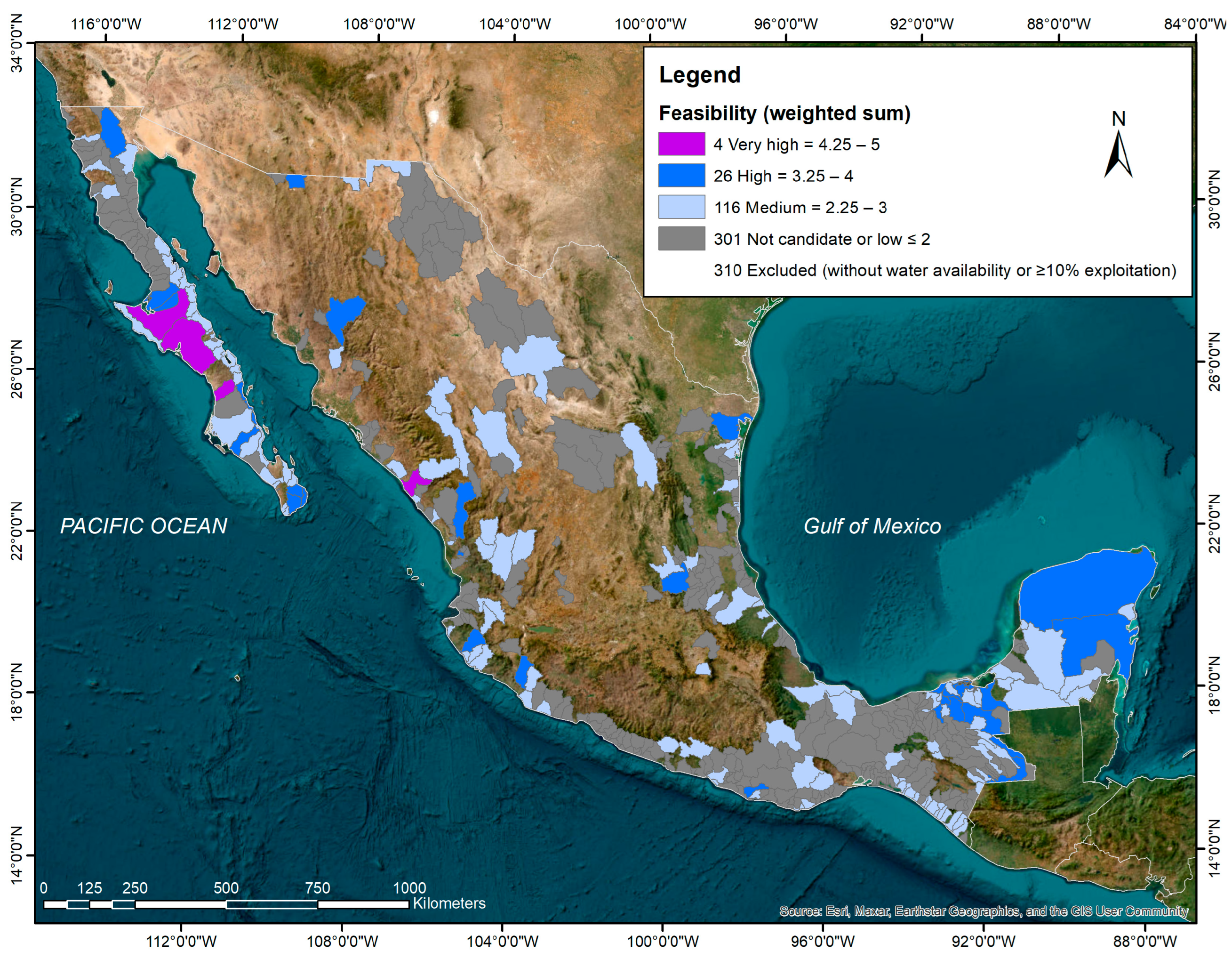
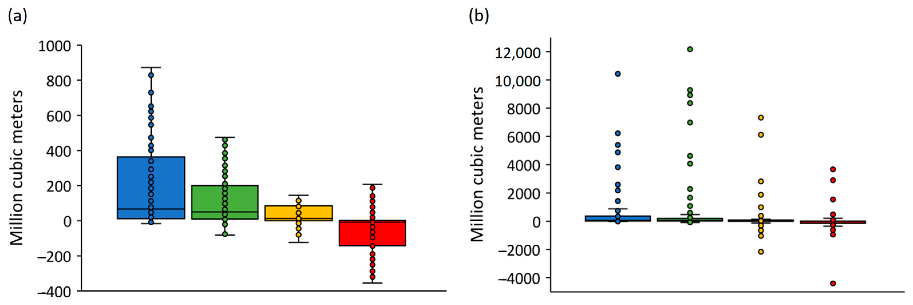
3.1. Feasibility Status of Water Reseves

The feasibility rankings of river basis range from medium to very high priority for conducting environmental flow assessments because they possess favorable conditions of water availability, low demand, and conservation interest (Equation (1) outcome ≥2.25), to non-eligible (≤2), or were excluded due to lack of water availability and/or present and stressed condition (≥10% water exploitation index). Unlike the previous analyses, the administrative division of hydrological basins now stands at 757, with 29 more management units than in 2011 (Table 3). Despite this increase, the overall rate of change is noteworthy, and, particularly, the loss of basins identified as potential water reserves (189 in 2011 vs. 146 in 2022, a decrease of 23%). Except for medium feasibility, which has remained relatively stable over time (~116), the rest of the prioritization categories have been affected.
In 2011, 54 basins with high feasibility were identified, while in 2022, there were only 26 remaining, roughly half. In 2011, 19 basins had very high feasibility, but in 2022, only 4 met the desired conditions. This can be explained by two reasons: the first is related to the number of basins that met all the assessment conditions (457 vs. 447). The second reason, which is related to the first, is due to the increase in excluded basins from the lack of mean annual surface water availability or an increase in water stress (271 vs. 310). This finding demonstrates that water use for productive uses continues to be environmentally and socially unsustainable despite the existing public policies and regulations during the analyzed period.
In terms of their geographical distribution, there is a significant number of potential water reserves in the Baja California (Northwest) and Yucatán (East) peninsulas. The first, despite the limited natural water available, this indicates that population growth remains low. The second reason is due to the abundant surface and groundwater available, with high conservation interest in both cases (Figure 2). The number of basins identified on the Pacific Ocean side stands out, subject to seasonal hydrological variability that distinguishes it significantly from those draining into the Gulf of Mexico side. Finally, it is worth noting that in the northern part of the country, there is still water available for the environment. In addition to the aforementioned potential reserves in the Baja California peninsula, there are also management units which meet the established criteria, located in the northwestern states of the hydrological regions 25 San Fernando–Soto La Marina and 34 Cuencas Centrales del Norte.

3.2. Effect of the Change on Protected Areas and Recognized Conservation Gaps

Currently, Mexico has a system of 187 federal protected areas covering a total of 909,673 km2, encompassing terrestrial ecosystems (173,818 km2 of continental surface, islands, and epicontinental water bodies), exclusive marine areas (440,433 km2), and mixed environments (295,422 km2 in coastal or terrestrial-marine areas) [59]. This evaluation of potential water reserves extends over 76,723 km2, with direct or indirect benefits to protected areas in case of enacting the environmental flows that sustain them (Table 4). This represents a difference of 9408 km2 compared to the initial report (11% rate of change during the analysis period) [14].
As for internationally important wetlands, there are currently 145 Ramsar sites covering an area of 87,274 km2 [60]. Since ecological processes in wetlands are dependent on flood regimes, 37,379 km2 are identified with direct benefits. This indicator shows an additional 8367 km2 compared to the previously reported figures (29% rate of change) [14].
To fully appreciate the potential benefits of protecting environmental flows through the identified potential reserves, it is necessary to consider them as part of the surface of the territory through which water flows, particularly in areas that currently lack legal protection instruments, such as protected areas and recognized gaps and omissions in conservation. In this regard, the global set of 146 potential water reserves implies a drainage area of 411,980 km2. Although this represents a −8% rate of change compared to what was reported previously [14], 90,438 km2 of the area corresponds to federal protected natural areas and internationally important wetlands. The remaining 321,542 km2 contains gaps and omissions in conservation (128,408 km2), and 193,134 km2 are identified as new areas of exclusively hydrological protection not covered by any current instrument. This represents a 146% increase compared to the potential water reserves of 2011. This positive difference is due to the increase of 29 hydrological basins from one period to another, with the southeastern peninsula region being a notable addition.

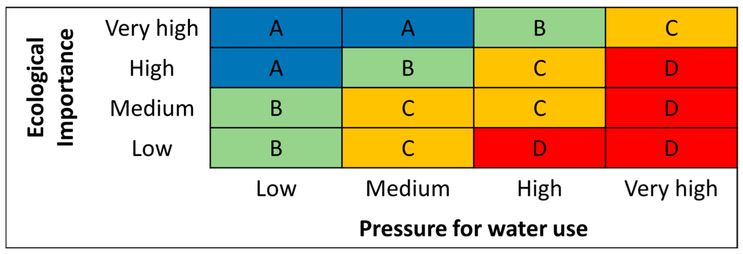
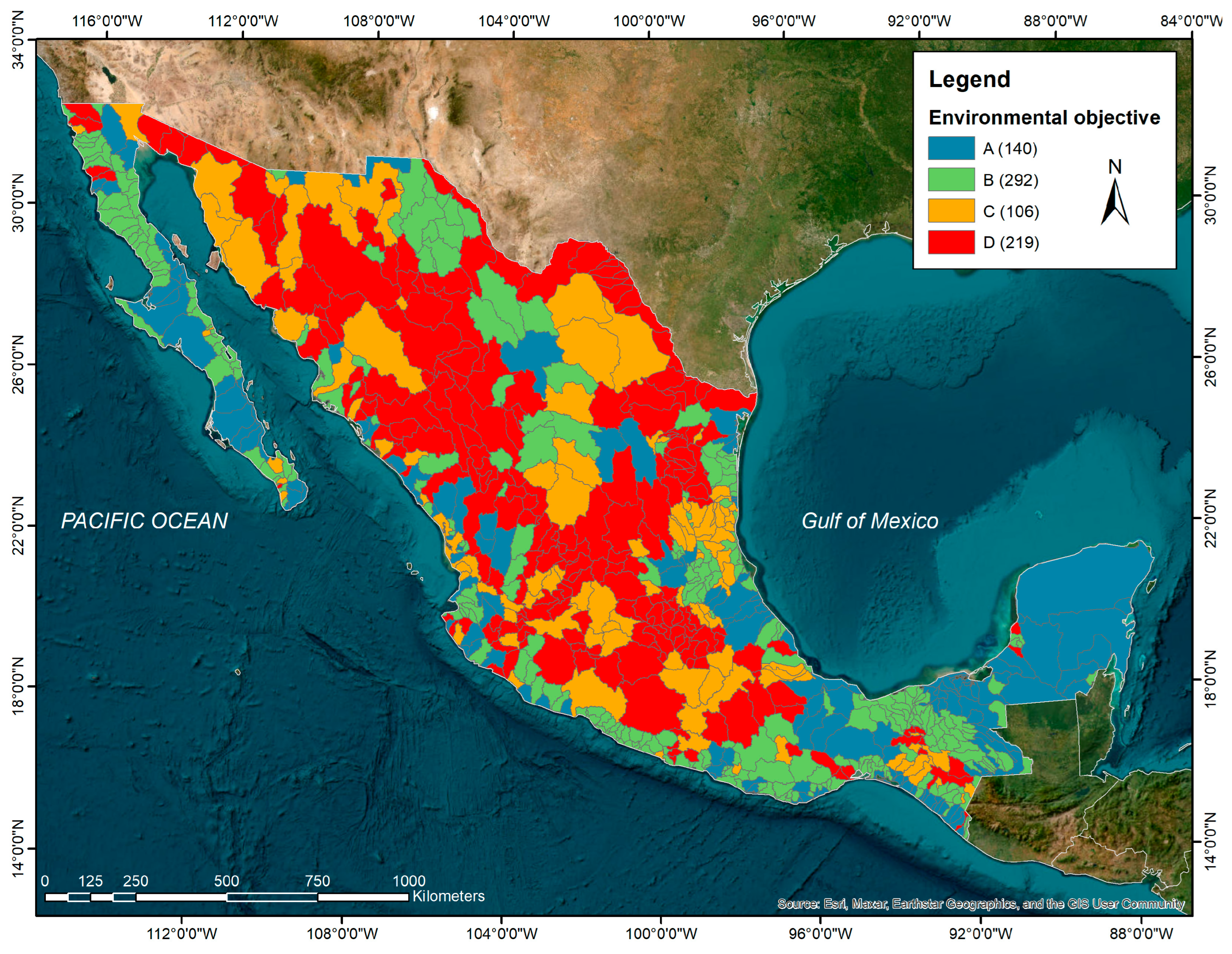
3.3. Environmental Objectives for Environmental Flow Assessments

In general, the classification of environmental objectives for hydrological basins follows the same trend as the identification of potential water reserves. Regarding water pressure or demand of use, the temporal analysis reveals increases with rates of change ranging from 5% to 21% between the low and very high classifications, respectively (Table 5). On the contrary, and despite the addition of 25 management units for the analysis period, the ecological importance in the basins reflects an opposing relationship, albeit to a lesser extent (1–12%). Given the changes in both pressure for water use and ecological importance, the classification of environmental objectives has also been impacted; in general, the most significant changes are found in the central categories (B–C). For the environmental objective class “D”, representing a desired conservation state labeled as deficient, the number of basins has increased from 156 to 220 (41% rate of change), while for class “C,” which represents a desired medium ecological state, the change decreased from 304 to 105 basins (−190%). On the other hand, the change for class “B” increased from 82 to 292 basins (256% with a desired good conservation state), and for class “A,” it decreased from 190 to 140 basins (26%).
Geographically, basins with environmental objectives of class “A” and “B” are mostly distributed in the two peninsulas, in coastal basins along both the Pacific Ocean and Gulf of Mexico, and with a small representation in the northwestern region, as well as in the central northern basins (Figure 3). In contrast, basins with environmental objectives of class “C” and “D” are concentrated in the northernmost region and in central-southern Mexico.

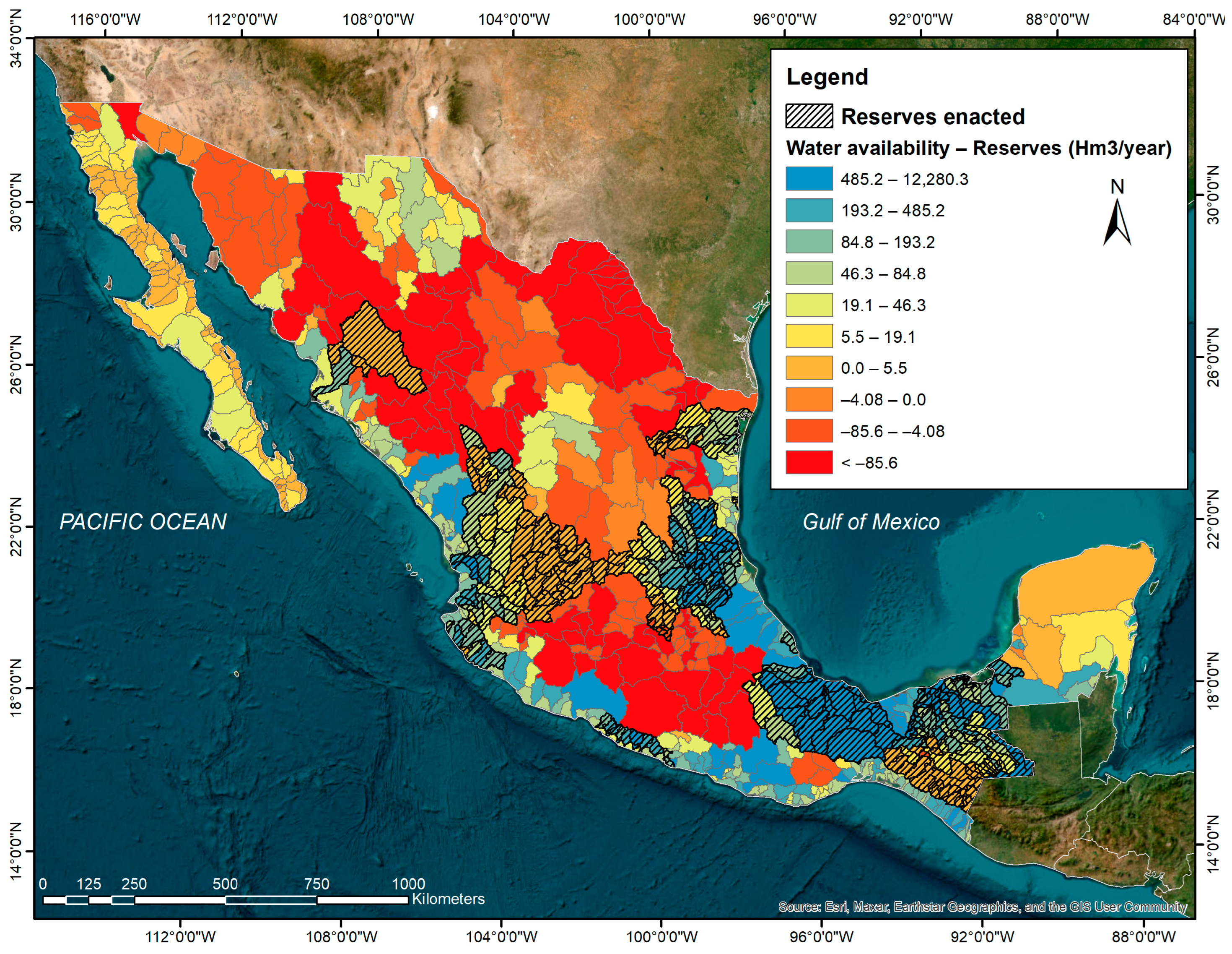
3.4. Gaps in Water Reserves for Management Planning

Out of the 757 basins in the country, 266 have existing water reserves. Among the remaining 491 basins, the use of reference values for reserve volumes for water planning reveals that 323 basins are suitable for establishing new reserves to meet national goals [21,24]. However, 168 of these basins are in deficit, meaning they lack sufficient availability (Table 6; Figure 4). As previously reported, these water availability deficient basins would require detailed environmental flow studies for flow regime reconstruction, adjustments to environmental objectives, and implementation strategies to involve the recovery of consumptive water volumes [12,17].
Regarding the relevance of water reserve volumes for water planning based on reference values, the proportion of basins with a surplus of water availability is concentrated in those with environmental objectives classes “A” and “B” (98% for each class), with the lowest number of outliers (11–12%) (Figure 5). Conversely, in deficit basins, both environmental objectives classes “C” and “D” experience the highest proportions of both conflict (75% and 45%, respectively) and outliers (25% and 29%, respectively).
In general, these results are consistent with the expected as previously reported, both in the method’s proof of concept as well as in case studies that include desktop assessments (ecohydrological methods) and others supported by holistic approaches [13,17,18,19,61,62]. However, the reserve volumes should be taken with caution due to their temporal resolution-related uncertainty, particularly in the desired conservation states of “medium” and “deficient”, and further considerations should be taken into account.
First, the water availability in the basin is mean annual-based and the extremes are not adequately accounted for (i.e., very dry and wet seasonal and yearly conditions). Although carried out at a country and global scale, annual-based water availability and environmental reserves tend to be a regular practice for water planning; there is evidence of inconsistency at finer scales [43,44,45]; drought cycles may affect environmental water reserve previsions provided by the reference values. Furthermore, another limitation to be considered is that the reference values were applied without differentiation between the type of dominant stream in the basins (e.g., perennial, intermittent, or ephemeral), since it is not possible to determine this from the availability balances [17,18,19]. To increase the certainty in these regards, bottom-up detailed methods are recommended, such as holistic ecohydrology-based, habitat simulation, expert panel, or research-driven methods.

3.5. Strategic Contributions of the Reserves to Public Policy and Potential Gains for the Conservation of Aquatic Ecosystem Connectivity

Although the reduction in feasible potential water reserves from 2011 to 2022 may have had an impact on the goal of establishing 189 reserves for ecological protection, currently, 266 have been established and remain in place. From the current set of basins with reserves, only 27 are identified as potential, so there are still 119 possible new establishments in accordance with the national goals [21,24]. As previously reported, the total set of established water reserves exceeded the goal due to management opportunities arising from hydrological connectivity between a select group of units and their contributing upstream basins [17,63]. To ensure the required volumes in the target reserves, it was necessary to ensure connectivity through availability balances, and consequently, reserve the water from the generating or contributing basins.
Unlike previous reports [17], the adjustment of the contribution of current reserves to the protection of flow regimes on the drainage network is around 443,000 km2, providing legal certainty to ensure connectivity, at least in good conservation condition, along ~41,600 km or 31% of the national hydrographic network, ~12,200 km2 in 39 Ramsar wetlands of international importance, ~59,850 km2 in 54 federal natural protected areas, as well as ~442,700 km2 with representation of 70% of the global aquatic ecosystem ecoregions present in Mexico (Table 7). In terms of biodiversity, this benefits at least ~240 protected species, ~180 of which are freshwater dependent (~80 protected) [38]. Moreover, according to a recent report from the International Union for Conservation of Nature (IUCN), this water protection scheme has the potential to improve the conservation status of 450 fish species in Mexico [64]. Based on the present evaluation of potential water reserves and basins with environmental objective class “A”, the gain for the conservation of aquatic ecosystem connectivity could increase to around 63,760–66,900 km of rivers with at least a good state of conservation in their connectivity (48–50% of the national hydrographic network), 48,650–49,600 km2 in 62–66 wetlands (43–46%), 128,700–136,500 km2 in 84–92 natural protected areas (45–49%), and 780,500–852,200 km2 with representation of 85–89% of the global freshwater ecoregions present in the country.
The experience gained in the allocation of water for the environment over the last decade is revealing for its scope and is acknowledged in scientific literature [3,9,16,56,57,63,64]. The results have the potential to be leveraged through public policy for water resources management, conservation, and addressing climate change. Currently, the federal government has the goal of increasing the number of basins with ecological reserves to 448, which means an addition of 182 to the existing ones, along with the development of complementing regulations to ensure the flow regime timing implementation [21,24,65]. Focusing the strategy on the remaining set of 119 basins with potential water reserves and the hydrologically connected management units would provide certainty regarding the current water availability, its low usage demand rates, and conservation interest, contributing at least 86% (385 out of the 448 reserves) towards achieving the goals of the National Water Program 2020–2024 and the Special Climate Change Program 2021–2024.
Such country-scale strategic environmental water implementation is aligned to the state-of-the-art calls for protecting and restoring habitats to mitigate the ongoing loss of freshwater biodiversity [2,3,56,57]. It builds on the commitment made by the government of Mexico, together with those from Colombia, Congo, Ecuador, Gabon, and Zambia at the United Nations (UN) 2023 Water Conference for the Freshwater Challenge (https://www.gob.mx/sre/prensa/mexico-joins-the-freshwater-challenge-to-restore-rivers-and-wetlands-and-address-water-scarcity?idiom=en) that aims to collectively restore 300,000 km of rivers and 350 million hectares of wetlands and address water scarcity. Furthermore, it is consistent with Target 3 of the Kunming-Montreal Global Biodiversity Framework, “ensure and enable that by 2030 at least 30 percent of terrestrial, inland water, and of coastal and marine areas are effectively conserved and managed through ecologically representative, well-connected and equitably governed systems of protected areas and other effective area-based conservation measures […]”, recently adopted by the Convention on Biological Diversity.

4. Conclusions and Recommendations

The results of this research show that over the last decade, the form and geospatial distribution of pressure or demand for water use in Mexico’s basins has been advancing at a higher rate compared to the creation of new protected areas. Although both aspects are crucial for achieving a balance between water use and conservation, water demand is the most determining factor reported in international literature and, therefore, limits the establishment of water reserves for ecological protection. It is an indicator of the level of over-exploitation of resources whose use alters the regime and pollutes water, leading to the loss or degradation of habitat (e.g., connectivity) and of species living in aquatic ecosystems.
The strategy adopted in Mexico to proactively implement environmental flows through water allocation for ecological protection, in basins with low water usage rates and significant conservation interest, has been successful according to performance indicators established in public policy instruments back in 2012 (266 reserves, 77 more than originally targeted) and recognized by specialized literature. However, this was due to the need—and the water management opportunity—to ensure the connectivity of environmental flows in a limited number of basins through all their contributing units located upstream. Currently, while reserves have been guaranteed in only 27 of the initially identified potential basins, there are still 119 management units that meet the conditions of low water usage rates and significant conservation interest; it is recommended to allocate environmental water in such basins. This number could contribute to approximately 86% of the goal set in national programs by 2024, with the certainty that they have water availability, low demand, and conservation interest for the protection of environmental flows, without considering the need to also ensure those of the contributing basins upstream. This has proven to have positive implications from water management.
The evaluation of environmental flows based on reference values for water planning shows that up to 78% of the country’s basins have sufficient and potential availability to manage their administrative implementation through the water reserves legal figure, regardless of their environmental objective class. However, given the associated uncertainty in basins with different desired conservation states, as well as the hydrological nature of the main watercourses (ephemeral, intermittent, or perennial), it is recommended to design differentiated strategies for their implementation. The strategies should be focused on enacting environmental reserves grounded on holistic ecohydrology-based studies in basins with sufficient availability and ecological importance, and developing the complementary regulation to secure timely implementation (i.e., conservation and management plans). The recommended strategy in basins without enough water availability should be focused on the reconstruction of environmental flow regimes, and grounded on holistic research-driven studies to support the corresponding restoration plans.
Finally, in light of our findings, current strategic environmental water allocation in the Mexican basins with certainty of low demand of use and high conservation importance with at least a good state of conservation in their connectivity will provide multiple benefits in the long term. From a management perspective, by enacting the flow regime protection in such basins, water abstractions will be preventively limited for up to 50 years to sustainable rates in around half of the country’s river network, protected areas, and wetlands of international importance, and avoid conflicts between people and nature in this increasingly scarce resource. Such implementation would mean an unprecedented country-scale measure to halt biodiversity loss in aquatic ecosystems. Moreover, it will bring Mexico closer to fulfilling the commitments made at the UN 2023 Water Conference and the Kunming-Montreal Global Biodiversity Framework, recently adopted by the parties to the Convention on Biological Diversity.

Supplementary Materials

The database for the current national assessment on the potential reserves (ranking), desired conservation status of the flow regime (environmental objective class), and environmental water reserve (reference values-based) per river basin are available online at https://0-www-mdpi-com.brum.beds.ac.uk/article/10.3390/d16030190/s1.

Author Contributions

Conceptualization, methodology, formal analysis, investigation, project administration, supervision, visualization, writing—original draft preparation, S.A.S.-R.; validation, resources, data curation, funding acquisition, writing—review and editing, S.A.S.-R. and A.I.M.P. All authors have read and agreed to the published version of the manuscript.

Funding

This research was funded by El Colegio de la Frontera Sur (ECOSUR) and the World Wildlife Fund Inc. (WWF Mexico), grant number ECOSUR/CONVENIO/E/030/VIH/2022. Furthermore, it supports the National Research and Advocacy Project “Ecohydrology for the sustainability and governance of water and basins for the common good”, funded by the Mexican National Council of Humanities, Sciences and Technologies and operated by the Water Reserves Monitoring Network, grant number 318956. The APC was funded WWF Mexico.

Institutional Review Board Statement

Not applicable.

Data Availability Statement

The data presented in this study are available in this published paper. Shapefiles are available upon request to the corresponding author.

Acknowledgments

We are thankful to Sofía Álvarez Castrejón for her support on the manuscript translation and style proofreading.

Conflicts of Interest

The authors declare no conflicts of interest.

References

  1. Forslund, A.D.; Renöfält, B.M.; Barchiesi, S.; Cross, K.; Davidson, S.; Farrell, T.; Korsgaard, L.; Krchnak, K.; McClain, M.; Meijer, K.; et al. Securing Water for Ecosystems and Human Well-Being: The Importance of Environmental Flows. SIWI. 2009. Available online: https://siwi.org/wp-content/uploads/2015/03/1250435228124report24_e-flows-low-res-3.pdf (accessed on 29 February 2024).
  2. Arthington, A.H.; Bhaduri, A.; Bunn, S.E.; Jackson, S.E.; Tharme, R.E.; Tickner, D.; Young, B.; Acreman, M.; Baker, N.; Capon, S.; et al. The Brisbane Declaration and Global Action Agenda on Environmental Flows (2018). Front. Environ. Sci. 2018, 6, 45. [Google Scholar] [CrossRef]
  3. Tickner, D.; Opperman, J.; Abell, R.; Acreman, M.; Arthington, A.H.; Bunn, S.E.; Cooke, S.J.; Dalton, J.; Darwall, W.; Edwards, G.; et al. Bending the Curve of Global Freshwater Biodiversity Loss: An Emergency Recovery Plan. BioScience 2020, 70, 330–342. [Google Scholar] [CrossRef]
  4. Dudgeon, D.; Arthington, A.H.; Gessner, M.O.; Kawabata, Z.-I.; Knowler, D.J.; Lévêque, C.; Naiman, R.J.; Prieur-Richard, A.-H.; Soto, D.; Stiassny, M.L.J.; et al. Freshwater biodiversity: Importance, threats, status and conservation challenges. Biol. Rev. 2006, 81, 163–182. [Google Scholar] [CrossRef] [PubMed]
  5. Reid, A.J.; Carlson, A.K.; Creed, I.F.; Eliason, E.J.; Gell, P.A.; Johnson, P.T.J.; Kidd, K.A.; Maccormack, T.J.; Olden, J.D.; Ormerod, S.J.; et al. Emerging threats and persistent conservation challenges for freshwater biodiversity. Biol. Rev. 2019, 94, 849–873. [Google Scholar] [CrossRef]
  6. Strayer, D.L.; Dudgeon, D. Freshwater biodiversity conservation: Recent progress and future challenges. J. N. Am. Benthol. Soc. 2010, 29, 344–358. [Google Scholar] [CrossRef]
  7. World Wildlife Fund for Nature (WWF). Living Planet Report 2022—Building a Naturepositive Society; WWF: Gland, Switzerland, 2022; Available online: https://wwfint.awsassets.panda.org/downloads/embargo_13_10_2022_lpr_2022_full_report_single_page_1.pdf (accessed on 19 December 2023).
  8. Grill, G.; Lehner, B.; Thieme, M.; Geenen, B.; Tickner, D.; Antonelli, F.; Babu, S.; Borrelli, P.; Cheng, L.; Crochetiere, H.; et al. Mapping the world’s free-flowing rivers. Nature 2019, 569, 215–221. [Google Scholar] [CrossRef] [PubMed]
  9. Perry, D.; Harrison, I.; Fernandes, S.; Burnham, S.; Nichols, A. Global Analysis of Durable Policies for Free-Flowing River Protections. Sustainability 2021, 13, 2347. [Google Scholar] [CrossRef]
  10. Acreman, M.; Arthington, A.H.; Colloff, M.J.; Couch, C.; Crossman, N.D.; Dyer, F.; Overton, I.; Pollino, C.A.; Stewardson, M.J.; Young, W. Environmental flows for natural, hybrid, and novel riverine ecosystems in a changing world. Front. Ecol. Environ. 2014, 12, 466–473. [Google Scholar] [CrossRef]
  11. Secretaría de Economía. Norma Mexicana. Que Establece el Procedimiento para la Determinación del Caudal Ecológico en Cuencas Hidrológicas. 2012. Available online: https://www.gob.mx/cms/uploads/attachment/file/166834/NMX-AA-159-SCFI-2012.pdf (accessed on 19 December 2023).
  12. Barrios Ordóñez, J.E.; Salinas Rodríguez, S.A.; Martínez, A.; López Pérez, M.; Villón Bracamonte, R.A.; Rosales Ángeles, F. National Water Reserves Program in Mexico. Experiences with Environmental Flows and the Allocation of Water for the Environment; BID-TN-864; Inter-American Development Bank, Water and Sanitation Sector, IDB: Washington, DC, USA, 2015. [Google Scholar] [CrossRef]
  13. Salinas-Rodríguez, S.A.; Barrios-Ordóñez, J.E.; Sánchez-Navarro, R.; Wickel, A.J. Environmental flows and water reserves: Principles, strategies, and contributions to water and conservation policies in Mexico. River Res. Appl. 2018, 34, 1057–1084. [Google Scholar] [CrossRef]
  14. Comisión Nacional del Agua (CONAGUA). Identificación de Reservas Potenciales de Agua para el Medio Ambiente en México. 2011. Available online: https://www.conagua.gob.mx/CONAGUA07/Publicaciones/Publicaciones/SGT-3-11Media.pdf (accessed on 19 December 2023).
  15. Horne, A.C.; O’Donnell, E.L.; Tharme, R.E. Chapter 17—Mechanisms to Allocate Environmental Water. In Water for the Environment; Horne, A.C., Webb, J.A., Stewardson, M.J., Richter, B., Acreman, M., Eds.; Academic Press: Cambridge, MA, USA, 2017; pp. 361–398. [Google Scholar] [CrossRef]
  16. Opperman, J.J.; Kendy, E.; Tharme, R.E.; Warner, A.T.; Barrios, E.; Richter, B.D. A Three-Level Framework for Assessing and Implementing Environmental Flows. Front. Environ. Sci. 2018, 6, 76. [Google Scholar] [CrossRef]
  17. Salinas-Rodríguez, S.A.; Barba-Macías, E.; Infante-Mata, D.; Nava-López, M.Z.; Neri-Flores, I.; Domínguez-Varela, R.; González-Mora, I.D. What Do Environmental Flows Mean for Long-term Freshwater Ecosystems’ Protection? Assessment of the Mexican Water Reserves for the Environment Program. Sustainability 2021, 13, 1240. [Google Scholar] [CrossRef]
  18. Salinas-Rodríguez, S.A.; Sánchez-Navarro, R.; Barrios-Ordóñez, J.E. Frequency of occurrence of flow regime components: A hydrology-based approach for environmental flow assessments and water allocation for the environment. Hydrol. Sci. J. 2020, 66, 193–213. [Google Scholar] [CrossRef]
  19. Salinas-Rodríguez, S.A.; van de Giesen, N.C.; McClain, M.E. Inter-Annual and Seasonal Variability of Flows: Delivering Climate-Smart Environmental Flow Reference Values. Water 2022, 14, 1489. [Google Scholar] [CrossRef]
  20. Secretaría de Medio Ambiente y Recursos Naturales (SEMARNAT). Acuerdo por el que se Actualiza la Disponibilidad Media Anual de las Aguas Nacionales Superficiales de las 757 Cuencas Hidrológicas que Comprenden las 37 Regiones Hidrológicas en que se Encuentra Dividido los Estados Unidos Mexicanos. 2020. Available online: https://www.dof.gob.mx/nota_detalle.php?codigo=5600849&fecha=21/09/2020#gsc.tab=0 (accessed on 19 December 2023).
  21. Secretaría de Medio Ambiente y Recursos Naturales (SEMARNAT). Programa Especial de Cambio Climático 2021–2024. 2021. Available online: https://www.gob.mx/cms/uploads/attachment/file/681172/PECC-2021-2024.pdf (accessed on 19 December 2023).
  22. Schroeder Aguirre, A.A.; Salinas Rodríguez, S.A. Guía para la Aplicación de la Norma Mexicana para la Determinación del Régimen de Caudal Ecológico en Cuencas Hidrológicas: Aproximaciones Hidrológicas, Hidrobiológicas y Holísticas; Comisión Nacional del Agua: Mexico City, Mexico, 2011.
  23. Comisión Nacional para el Conocimiento y Uso de la Biodiversidad y Comisión Nacional de Áreas Naturales Protegidas (CONABIO-CONANP). Sitios Prioritarios para la Conservación de los Ecosistemas Acuáticos Epicontinentales. 2010. Available online: http://www.conabio.gob.mx/informacion/gis/?vns=gis_root/region/biotic/spec1mgw (accessed on 19 December 2023).
  24. Secretaría de Medio Ambiente y Recursos Naturales (SEMARNAT). Decreto por el que se Aprueba el Programa Nacional Hídrico 2020–2024. 2020. Available online: https://www.dof.gob.mx/nota_detalle.php?codigo=5609188&fecha=30/12/2020#gsc.tab=0 (accessed on 19 December 2023).
  25. Abell, R.; Thieme, M.L.; Revenga, C.; Bryer, M.; Kottelat, M.; Bogutskaya, N.; Coad, B.; Mandrak, N.; Balderas, S.C.; Bussing, W.; et al. Freshwater Ecoregions of the World: A New Map of Biogeographic Units for Freshwater Biodiversity Conservation. BioScience 2008, 58, 403–414. [Google Scholar] [CrossRef]
  26. Sánchez Montufar, O.; Technical Advisory Manager, Transparency Liaison of the General Technical Subdirectorate, National Water Commission, Mexico City, Mexico; Salinas Rodríguez, S.A.; Associate Researcher, Department of Sustainability Sciences, El Colegio de la Frontera Sur, Villahermosa, Tabasco, Mexico. (Folio No. 1610100126621 and Official Letter No. B00.7.03-022). Personal communication, 2021.
  27. Secretaría de Medio Ambiente y Recursos Naturales (SEMARNAT). Acuerdo por el que se Actualiza la Disponibilidad Media Anual de Agua Subterránea de los 653 Acuíferos de los Estados Unidos Mexicanos, Mismos que Forman Parte de las Regiones Hidrológico-Administrativas que se Indican. 2020. Available online: https://dof.gob.mx/nota_detalle.php?codigo=5600593&fecha=17/09/2020#gsc.tab=0 (accessed on 19 December 2023).
  28. Comisión Nacional para el Conocimiento y Uso de la Biodiversidad (CONABIO). Áreas Naturales Protegidas, Estatales, Municipales, Ejidales, Comunitarias y Privadas de México. 2020. Available online: http://www.conabio.gob.mx/informacion/gis/maps/geo/anpest20gw.zip (accessed on 19 December 2023).
  29. Comisión Nacional de Áreas Naturales Protegidas (CONANP). Información Espacial de las Áreas Naturales Protegidas. 2023. Available online: http://sig.conanp.gob.mx/website/pagsig/info_shape.htm (accessed on 19 December 2023).
  30. Comisión Nacional del Agua (CONAGUA). Distritos y Unidades de Riego. 2022. Available online: https://sinav30.conagua.gob.mx:8080/SINA/?opcion=distritosr (accessed on 6 February 2024).
  31. Comisión Nacional del Agua (CONAGUA). Presas Principales. 2022. Available online: https://sinav30.conagua.gob.mx:8080/SINA/?opcion=monitoreo (accessed on 6 February 2024).
  32. Comisión Nacional de Población (CONAPO). Proyección de la Población de los Municipios de México, 2015–2030. 2019. Available online: http://www.conapo.gob.mx/work/models/CONAPO/Datos_Abiertos/Proyecciones2018/base_municipios_final_datos_02.rar (accessed on 6 February 2024).
  33. Insituto Nacional de Estadística Geografía e Informática (INEGI). Censo de Población y Vivienda 2010. 2010. Available online: https://www.inegi.org.mx/programas/ccpv/2010/#Datos_abiertos (accessed on 6 February 2024).
  34. Insituto Nacional de Estadística Geografía e Informática (INEGI). Censo de Población y Vivienda 2020. 2020. Available online: https://www.inegi.org.mx/programas/ccpv/2020/#Datos_abiertos (accessed on 6 February 2024).
  35. Gleeson, T.; Richter, B. How much groundwater can we pump and protect environmental flows through time? Presumptive standards for conjunctive management of aquifers and rivers. River Res. Appl. 2018, 34, 83–92. [Google Scholar] [CrossRef]
  36. Tharme, R.E. A global perspective on environmental flow assessment: Emerging trends in the development and application of environmental flow methodologies for rivers. River Res. Appl. 2003, 19, 397–441. [Google Scholar] [CrossRef]
  37. Poff, N.L.; Tharme, R.E.; Arthington, A.H. Evolution of Environmental Flow Assessments: Science, principles, and methodologies. In Water for the Environment: From Policy and Science to Implementation and Management; Horne, A., Webb, J.A., Stewardson, M.J., Richter, B., Acreman, M., Eds.; Academic Press: San Diego, CA, USA, 2017; pp. 203–236. [Google Scholar] [CrossRef]
  38. Salinas Rodríguez, S.A. Contribución de las Reservas de Agua para Protección Ecológica en Materia de Conservación de la Biodiversidad: Línea Base para la Selección de Objetos Estratégicos de Conservación; Red de Monitoreo de Reservas de Agua: Mexico City, Mexico, 2022; p. 20. [Google Scholar]
  39. Bunn, S.E.; Arthington, A.H. Basic Principles and Ecological Consequences of Altered Flow Regimes for Aquatic Biodiversity. Environ. Manag. 2002, 30, 492–507. [Google Scholar] [CrossRef] [PubMed]
  40. Davies, S.P.; Jackson, S.K. The biological condition gradient: A descriptive model for interpreting change in aquatic ecosystems. Ecol. Appl. 2006, 16, 1251–1266. [Google Scholar] [CrossRef]
  41. Martínez-Pacheco, A.I.; Salinas-Rodríguez, S.A. Servidor Cartográfico del Programa Nacional de Reservas de Agua, Versión 10.2; World Wildlife Fund Inc.: Mexico City, Mexico, 2018.
  42. Secretaría de Medio Ambiente y Recursos Naturales y Comisión Nacional de Áreas Naturales Protegidas (SEMARNAT-CONANP). Programa de Manejo: Reserva de la Biósfera Marismas Nacionales; SEMARNAT-CONANP: Mexico City, Mexico, 2013; p. 199. Available online: https://www.conanp.gob.mx/que_hacemos/pdf/programas_manejo/2013/MARISMAS.pdf (accessed on 29 February 2024).
  43. Sood, A.; Smakhtin, V.; Eriyagama, N.; Villholth, K.G.; Liyanage, N.; Wada, Y.; Ebrahim, G.; Dickens, C. Global Environmental Flow Information for the Sustainable Development Goals; International Water Management Institute (IWMI): Colombo, Sri Lanka, 2017; p. 37. [Google Scholar]
  44. Mekonnen, M.M.; Hoekstra, A.Y. Four billion people facing severe water scarcity. Sci. Adv. 2016, 2, e1500323. [Google Scholar] [CrossRef] [PubMed]
  45. Messager, M.L.; Dickens, C.W.S.; Eriyagama, N.; Tharme, R.E. Limited comparability of global and local estimates of environmental flow requirements to sustain river ecosystems. Environ. Res. Lett. 2024, 19, 024012. [Google Scholar] [CrossRef]
  46. Secretaría de Medio Ambiente y Recursos Naturales (SEMARNAT). Decreto por el que se deja Insubsistente el Diverso por el que se Suprimen las Vedas Existentes en las Cuencas Hidrológicas Río Actopan y Río Antigua, de la Subregión Hidrológica Papaloapan A, de la Región Hidrológica Número 28 Papaloapan, y se Establecen Reservas Superficiales para Usos Doméstico, Público Urbano y Ambiental o para la Conservación Ecológica en las Mismas Cuencas Hidrológicas, Publicado el 6 de Junio de 2018. 2022. Available online: https://www.dof.gob.mx/nota_detalle.php?codigo=5652171&fecha=17/05/2022#gsc.tab=0 (accessed on 19 December 2023).
  47. Secretaría de Medio Ambiente y Recursos Naturales (SEMARNAT). Decreto por el que se Deja sin Efectos el Diverso por el que se Suprimen las Vedas Existentes en las Cuencas Hidrológicas Río Papagayo 1, Río Petaquillas, Río Omitlán, Río Papagayo 2, Río Papagayo 3, Río Papagayo 4, Río Nexpa 1, Río Nexpa 2, Río La Arena 1 y Río La Arena 2, Pertenecientes a la Región Hidrológica Número 20 Costa Chica de Guerrero y se Establecen Zonas de Reserva de Aguas Nacionales Superficiales para los Usos Doméstico, Público Urbano y Ambiental o para Conservación Ecológica en las Cuencas Hidrológicas que se Señalan, las Cuales Forman Parte de la Región Hidrológica antes Referida, Publicado el 6 de Junio de 2018. 2022. Available online: https://www.dof.gob.mx/nota_detalle.php?codigo=5650819&fecha=03/05/2022#gsc.tab=0 (accessed on 19 December 2023).
  48. Vannote, R.L.; Minshall, G.W.; Cummins, K.W.; Sedell, J.R.; Cushing, C.E. The River Continuum Concept. Can. J. Fish. Aquat. Sci. 1980, 37, 130–137. [Google Scholar] [CrossRef]
  49. Ward, J. The four-dimensional nature of lotic ecosystems. J. N. Am. Benthol. Soc. 1989, 8, 2–8. [Google Scholar] [CrossRef]
  50. Junk, W.; Bailey, P.B.; Sparks, R.E. The Flood pulse concept in river-floodplain systems. In Proceedings of the International Large River Symposium; Dodge, D.P., Ed.; Fish and Aquatic Science: Honey Harbour, ON, Canada, 1989; Volume 106, pp. 110–127. Available online: https://publications.gc.ca/collections/collection_2016/mpo-dfo/Fs41-31-106-eng.pdf (accessed on 29 February 2024).
  51. Junk, W.J. The flood pulse concept of large rivers: Learning from the tropics. SIL Proc. 1922–2010 2001, 27, 3950–3953. [Google Scholar] [CrossRef]
  52. Grantham, T.E.; Matthews, J.H.; Bledsoe, B.P. Shifting currents: Managing freshwater systems for ecological resilience in a changing climate. Water Secur. 2019, 8, 100049. [Google Scholar] [CrossRef]
  53. Poff, N.L. A river that flows free connects up in 4D. Nature 2019, 569, 201–202. [Google Scholar] [CrossRef] [PubMed]
  54. Poff, N.L.; Allan, J.D.; Bain, M.B.; Karr, J.R.; Prestegaard, K.L.; Richter, B.D.; Sparks, R.E.; Stromberg, J.C. The natural flow regime: A new paradigm for riverine conservation and restoration. BioScience 1997, 47, 769–784. [Google Scholar] [CrossRef]
  55. Richter, B.; Baumgartner, J.; Wigington, R.; Braun, D. How Much Water Does A River Need? Freshw. Biol. 1997, 37, 231–249. [Google Scholar] [CrossRef]
  56. Arthington, A.H.; Tickner, D.; McClain, M.E.; Acreman, M.C.; Anderson, E.P.; Babu, S.; Dickens, C.W.S.; Horne, A.C.; Kaushal, N.; Monk, W.A.; et al. Accelerating environmental flows implementation to bend the curve of global freshwater biodiversity loss. Environ. Rev. 2023, 1–27. [Google Scholar] [CrossRef]
  57. Piczak, M.; Perry, D.; Cooke, S.J.; Harrison, I.; Benitez, S.; Koning, A.A.; Peng, L.; Limbu, P.; Smokorowski, K.; Salinas-Rodríguez, S.A.; et al. Protecting and restoring habitats to benefit freshwater biodiversity. Environ. Rev. 2023. [Google Scholar] [CrossRef]
  58. Grill, G.; Lehner, B. Mapping the world’s free-flowing rivers: Data set and technical documentation. Nature 2019. [Google Scholar] [CrossRef]
  59. Comisión Nacional de Áreas Naturales Protegidas (CONANP). Numeralia Sobre la Áreas Naturales Protegidas de México; CONANP: Mexico City, Mexico, 2023.
  60. Ramsar Convention Secretariat. Wetlands of International Importance in Mexico. 2023. Available online: https://www.ramsar.org/es/country-profile/mexico (accessed on 19 December 2023).
  61. De La Lanza Espino, G.; Carbajal Pérez, J.L.; Salinas Rodríguez, S.A.; Barrios Ordoñez, J.E. Medición del caudal ecológico del río Acaponeta, Nayarit, comparando distintos intervalos de tiempo. Investig. Geográficas 2012, 78, 62–74. [Google Scholar] [CrossRef]
  62. De la Lanza Espino, G.; Carbajal Pérez, J.L.; Salinas Rodríguez, S.A. Cálculo de flujo ambiental como sustento para la reserva de agua del río Piaxtla, Sinaloa, México. Investig. Geográficas 2014, 87, 25–38. [Google Scholar] [CrossRef]
  63. Opperman, J.J.; Kendy, E.; Barrios, E. Securing Environmental Flows Through System Reoperation and Management: Lessons From Case Studies of Implementation. Front. Environ. Sci. 2019, 7, 104. [Google Scholar] [CrossRef]
  64. Lyons, T.J.; Máiz, T.L.; Tognelli, M.; Daniels, A.; Meredith, C.; Bullock, R.; Harrison, I. The Status and Distribution of Freshwater Fishes in Mexico; IUCN: Cambridge, UK; Albuquerque, NM, USA, 2020; Available online: https://portals.iucn.org/library/sites/library/files/documents/RL-72-002.pdf (accessed on 29 February 2024).
  65. Secretaría de Medio Ambiente y Recursos Naturales (SEMARNAT). Lineamientos para Incluir Volúmenes no Comprometidos de Aguas Nacionales Superficiales en los 10 Decretos de Reservas de Agua, Publicados el 6 de Junio de 2018 a Través de la Programación Hídrica. 2019. Available online: https://www.dof.gob.mx/nota_detalle.php?codigo=5564306&fecha=27/06/2019#gsc.tab=0 (accessed on 19 December 2023).
Figure 1. Matrix for the classification of environmental objectives. Source: Mexican Norm NMX-AA-159-SCFI-2012.
Diversity 16 00190 g001
Figure 2. Geographic distribution of basins identified as potential water reserves.
Diversity 16 00190 g002
Figure 3. Geographic distribution of the environmental objectives’ classes by hydrological basin.
Diversity 16 00190 g003
Figure 4. Geographical locations of the country’s basins with current water reserves, and the surplus and deficit of water availability for the establishment of new reserves (volume of current water availability minus reserves).
Diversity 16 00190 g004
Figure 5. Exploratory analysis of water availability volumes in million cubic meters based on reference values for ecological reserve by class of environmental flow objectives (A = blue, B = green, C = yellow, D = red), with focus on (a) central frequency distribution values within upper and lower limits (quartile 3 and 1 ± 1.5 times the interquartile range, respectively) and (b) outliers.
Diversity 16 00190 g005
Table 1. Key variables by hydrological basin and information sources for the identification of potential water reserves. Source: Authors’ own elaborations based on [12,14].
VariableReasoningSource
Water availability. For surface waters, it is the difference in volume that results between the mean annual runoff from the hydrological basin downstream and the volume committed by water usage. For groundwater, it is the difference between the mean annual recharge volume, the natural committed discharge, and the extraction of groundwater.It is the determining indicator for the creation of reserves with a preventive focus. If there is no water available in the hydrological basin, water cannot be allocated to the environment.Surface and groundwater mean annual site-specific balances; SEMARNAT and CONAGUA [20,26,27].
Water Stress. The percentage relationship between the mean annual surface runoff, including that generated within the own basin and that coming from upstream sources (or recharge in the case of aquifers), and the volumes extracted for productive water uses, losses due to evaporation, and reservoir level variations.It is an indicator of the degree of water resource exploitation (i.e., pressure for use). With higher demand, there is increased competition for water and reduced potential for establishing reserves.Calculated based on water availability studies [20,26,27].
Water bans. A management tool in response to water overexploitation, or in situations of extreme drought (severe scarcity), or in an emergency caused by water pollution, exploitation, use, or utilization.The existence of water bans is crucial for the establishment of reserves as they provide legal precedent, and are the basis for the reserves with an availability preventive cause.SEMARNAT and CONAGUA [20,26,27].
Water reserves. A management tool to allocate volumes for domestic or urban–public use, energy generation for public service, or to ensure minimum flows for ecological protection, including the conservation or restoration of vital ecosystems.Legal foundation for their establishment and an indicator of progress in public policy for the allocation of water to the environment.Environmental flow site specific assessments; SEMARNAT and CONAGUA [17,20,26,27].
Conservation value. Natural Protected Areas at federal, state, and municipal levels, as well as areas voluntarily designated for conservation, internationally important wetlands (Ramsar sites), and the priorities, gaps, or omissions in the conservation of epicontinental aquatic biodiversity.The circulation of water in the environment is fundamental for sustaining the ecological functioning of natural areas recognized by the state. Conservation objectives such as species, habitats, and vegetation types are linked to these spaces; therefore, they require the establishment of water reserves for ecological protection.CONABIO and CONANP [23,28,29].
Irrigation districts and units.Irrigation farming has a direct effect on land use change and alterations to the natural runoff regime, which is key to establishing the environmental flows that support the reserves.CONAGUA [30].
Location and volumes of large dams (≥15 m curtain height compared to the maximum level of ordinary flow or ≥3 Hm3 capacity).Demand of water use indicator; it may limit the reserves.CONAGUA [31].
Total population, density, and growth rate.Development indicators; the higher the population, density, and growth rate, the larger the demand for water use and lower feasibility for establishing reserves.CONAPO and INEGI [32,33,34].
Table 2. Variables, interpretation, criteria, and weighting factors for the feasibility assessment of potential water reserves. NPA: natural protected area (all categories considered: flora and fauna protection area, natural resources protection area, national monument, national park, and biosphere reserve); Bs: basin surface; Ids: irrigation district surface; As: aquifer surface; Dcv: dam capacity volume; Bmar: basin mean annual runoff (generated within the basin and the one coming from upstream). Source: elaborated by the authors from [12,14].
VariableInterpretationCriterionValue
Surface water availability (I)ExcludingAvailability < 0 Hm3(-.--)
Water stress ExcludingExploitation ≥ 10%(-.--)
Surface water availability (II)PositiveVolume > 0 Hm31
Conservation valuePositivePresence of Ramsar site1
Presence of a Federal NPA1
A total of ≥34 gaps and omissions of epicontinental aquatic conservation1
BansPositivePresence1
Irrigation districtsNegativeIds/Bs ≤ 1%0
Ids/Bs ≤ 10%−0.25
Ids/Bs > 10%−0.5
DamsNegativeDcv/Bmar ≤ 1%0
Dcv/Bmar ≤ 10%−0.25
Dcv/Bmar > 10%−0.5
Risk of impact to the basin from groundwater extraction (groundwater stress)NegativeLow= As/Bs < 100%0
High= As/Bs < 1%0
High= As/Bs ≤ 10%−0.25
High= As/Bs > 10%−0.5
Population densityNegativeDensity ≤ 25 inhab/km20
Density ≤ 50 inhab/km2−0.25
Density > 50 inhab/km2−0.5
Table 3. Number of basins by their level of feasibility as potential water reserves for ecological protection through time (2011–2022).
Feasibility2011201320162022
Very High191934
High54483626
Medium116116108116
Potential water reserve189183147146
Non eligible268276286301
Analyzed basins457459433447
Excluded basins271273298310
Total basins728732731757
Table 4. Extensions in square kilometers of potential water reserves, natural protected areas, internationally important wetlands, and gaps and omissions in the conservation of epicontinental aquatic ecosystems.
FeasibilityVery HighHighMediumTotal
Potential water reserve26,241144,450241,289411,980
Natural Protected Areas15,43123,71837,57576,723
 Flora and Fauna Protection Area13668603852718,496
 Natural Resources Protection Area01643104326
 National Monument0274269
 National Park0194443637
 Biosphere Reserve14,06414,87524,24153,179
 Sanctuary041115
Ramsar Sites738718,52511,46737,379
Gaps and omissions (class)895338,40081,055128,408
 Extreme3899936723,28736,553
 High311212,20316,64331,957
 Medium194216,83041,12559,897
Table 5. Numbers of basins for the evaluation of environmental flows in each level of pressure for water use, ecological importance, and classification of environmental objectives through time.
Description201220162022
Pressure for water use
 Low423387399
 Medium686476
 High343533
 Very High207245249
Ecological importance
 Low174182170
 Medium262252292
 High230227236
 Very High667059
Environmental objective—Desired conservation status
 D—Deficient156144219
 C—Medium304276106
 B—Good8293292
 A—Very good190218140
Table 6. Numbers of basins by environmental objective, with and without available water volume, for the allocation of ecological protection reserves based on the use of reference values for water planning.
Environmental Objective—Desired Conservation StatusSurplusDeficitTotal
D—Deficient87132219
C—Medium8026106
B—Good2857292
A—Very good1373140
Total589168757
Table 7. Strategic and potential contributions of the water reserves and numbers of basins with environmental objective class “A” for environmental flow assessments, according to NMX-AA-159-SCFI-2012 on conservation objects dependent on the flow regime.
Conservation Objects Dependent on the Flow RegimeCurrent Reserves (266 Baseline)Potential Reserves (146)Basins with a Class “A” Environmental Objective
Federal Natural Protected Areas (km2)59,85276,72368,841
Wetlands of international importance (km2)12,21737,37936,438
Ecohydrological connectivity of free-flowing rivers at least in good conservation state (km)41,63225,30622,162
Free-flowing rivers from source to mouth37,97423,37720,668
Good conservation status365719301494
Freshwater ecoregions (km2)442,742409,483337,772
Ameca–Manantlan23,63216,29211,939
Chiapas–Fonseca45514,7628083
Coatzacoalcos19,3926565
Colorado065666566
Cuatro Cienegas000
Gila014921492
Grijalva–Usumacinta69,32546,01044,030
Guzman–Samalayuca3953185318
Lerma–Chapala4621688305
Llanos El Salado883152315231
Lower Rio Grande–Bravo23,46974307240
Mayran–Viesca16,74144,29721,505
Panuco73,71017,59026,647
Papaloapan50,33715,69110,732
Quintana Roo–Motagua029,80129,801
Rio Balsas170621341296
Rio Conchos7432590
Rio Salado000
Rio San Juan (Mexico)3045353
Rio Santiago84,41816,02814,080
Sierra Madre of the South814993724134
Sinaloa34,17517,11213,428
Sonora707888319
Southern California Coastal–Baja California070,31150,415
Upper Rio Grande–Bravo22,62711,3620
Upper Usumacinta063,73111,362
Yucatan0063,731
Disclaimer/Publisher’s Note: The statements, opinions and data contained in all publications are solely those of the individual author(s) and contributor(s) and not of MDPI and/or the editor(s). MDPI and/or the editor(s) disclaim responsibility for any injury to people or property resulting from any ideas, methods, instructions or products referred to in the content.

