
Information Model for Sustainable Rural Development


1
Independent Researcher, 02-414 Warsaw, Poland
2
Independent Researcher, Matan 45858, Israel
*
Author to whom correspondence should be addressed.
Energies 2022, 15(11), 4009; https://0-doi-org.brum.beds.ac.uk/10.3390/en15114009
Submission received: 25 April 2022
/
Revised: 25 May 2022
/
Accepted: 27 May 2022
/
Published: 30 May 2022
(This article belongs to the Special Issue Advances in Scientific, Economic and Policy Analysis for Sustainable Development)
Abstract
:Currently, the sustainable development of rural areas is relevant for various countries, both developed and developing. The improvement of existing approaches for the assessment and management of rural settlement systems is particularly relevant for Belarus, as a country with agricultural resources. Currently, there is no eligible information model for a rural settlement system in Belarus. The main research aim of this study was to develop the information model for formulation and assessment of the settlement scenarios for solving the issue of sustainable rural development in Belarus. The research methods were based on the complex and interdisciplinary approaches, including the systems approach, factor analysis, comparative analysis, spatial and mathematical modelling, SWOT analysis, and the hierarchy method. The paper proposes the development of the informational model of a rural settlement system at a local planning level, including five main determinants of sustainability, namely social, technological, economic, environmental, and political. The model was approved by the assessment of development scenarios for the Zavalocycy local council as the first-level unit of a planning system. We obtained the development indexes for 14 rural settlements within the obtained assessment criteria. The research results showed the relevance of the informational model for the monitoring of sustainable development at a local planning level.
1. Introduction
Sustainable spatial development is a comprehensive and interdisciplinary research issue. The development of new models for assessing the spatial sustainability is relevant for many countries, both developed and developing [1,2,3,4,5]. It should be noted that the issue of rural development has been subjected to much less research analysis than the more general topic of urban planning. Sustainable development is the main goal of strategic planning, which is based on an interdisciplinary approach. Such an approach was successfully implemented in the strategic plans of European cities [6]. It seems possible to use best practices in developing a strategy of sustainable rural development considering the specifics of a rural settlement system. The rural settlement system in Belarus is finely dispersed and generally represented by small settlements. It is difficult to provide basic social services, improve living standards, and ensure sustainable development, while ensuring social standards [7]. One of the key tools of sustainable development is an effective spatial policy that ensures the organization of the settlement system through the definition of socio-cultural, industrial, recreational, and tourist centers within livable interconnections. All of strategic planning policies, including social, economic, and environmental, involve spatial implementation issues which should be highly correlated within the development of spatial policy.
The actual research in the area of sustainable development covers the issues of multifunctional development [8], smart specialization in regional development [9,10], socio-economic heterogeneity of rural areas [11], rural landscape conservation [12,13], socioeconomic and spatial resilience [14,15,16,17], new tools for ensuring rural sustainability [18], socio-economic transformation [19,20], spatio-temporal modelling [21,22], studies on environmental, economic, and social determinants [23,24,25,26,27], and modelling peri-urban areas [28,29,30,31]. The most recent studies on the subject of rural development are aimed at determining the sustainability factors at varied levels of land use planning. Stanny et al. and Rosner et al. showed the role of social innovation and social economy institutions in the development of rural areas [11,19]. Cárdenas Alonso et al. identified three key factors for achieving the sustainable development goals for rural areas in Spain: physical, demographic, and socioeconomic characteristics [24]. The model proposed by Prevolšek et al. is based on hierarchical relations consisting of three basic criteria of sustainable development: economic, social, and environmental [2]. The aim of the study on regional development in Poland was to show the impact of the transportation component on sustainable socio-economic development [32]. Yang et al. focused their study on socio-economic factors and management [33]. A detailed list of rural development indicators was suggested by Gupta [34]. A total of 79 indicators were classified into 7 groups, including basic data, social, economic, educational, wellness and health, access to public amenities, and natural environment. A. Górecka et al. discussed European regulations of smart villages, defining the challenges and smart village traps in rural development and ways to prevent these [35].
There are several important challenges of rural development in Belarus, including depopulation caused by migration, insufficient budget financing, production decrease in private farm holdings, weak rural-urban connections, etc. Considering that the settlement structure of Belarus is similar to a number of European countries, it is advisable to formulate an informational model using actual experiences of regional planning [36,37].
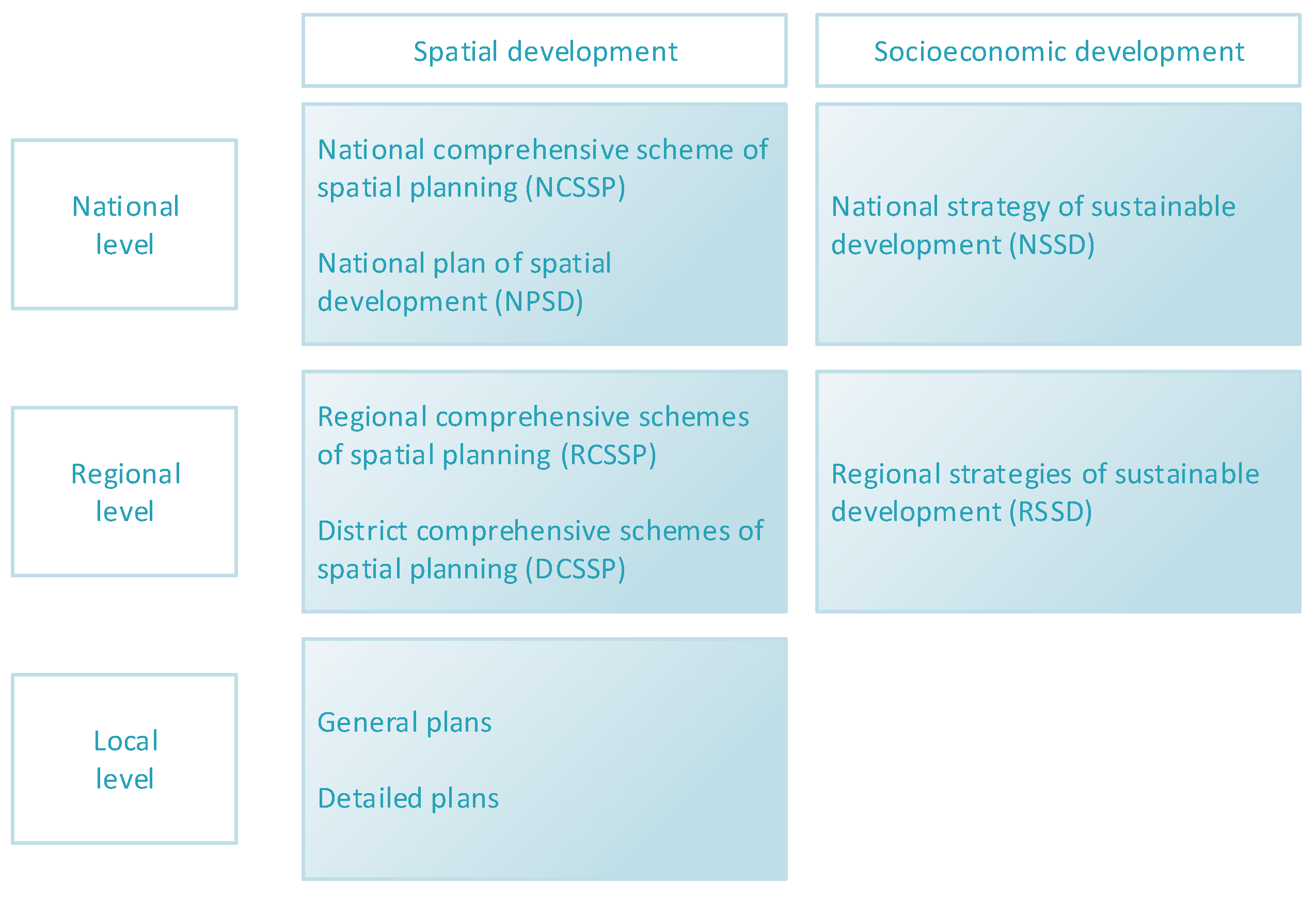
Belarus has a hierarchical administrative system. At the regional level, Belarus is divided into six regions (voblasts). At the local level, the regions are divided into districts (raions). Such an administrative system was set up in 1960 and remained unchanged even after the collapse of the Soviet Union. Belarus’ planning system is represented as a combination of development documents at the national, regional, and local levels, as shown in Figure 1. The national level covers the whole Belarus territory, or two or more regions. The regional level covers a territory of a region or group of administrative districts. The local level covers a territory of a single administrative district or settlement, or its part. The primary unit at the local planning level in Belarus is the local council, which consists of several rural settlements, including the system center and the agro-town. All planning documentations are divided into three main types: comprehensive planning, specialized planning, and detailed planning.
The Mogilev region is located in the eastern part of the country and neighbors the Smolensk and Bryansk regions of Russia. The territory of the Mogilev region covers an area of 29.1 thousand square kilometers. The Mogilev region includes 21 districts (Belynichi, Bobruisk, Bykhovsky, Hlussky, Goretsky, Dribinsky, Kirovsky, Klimovichsky, Klichevsky, Kostyukovichsky, Krasnopolsky, Krichevsky, Kruglyansky, Mogilevsky, Mstislavsky, Osipovichsky, Slavgorodsky, Khotimsky, Chaussky, Cherikovsky, and Shklovsky) and 2 districts in the Mogilev City; 17 cities, including two regional subregions—Mogilev and Bobruisk, 6 urban-type settlements, and 2966 rural settlements, including 203 agro-towns.
As of 1 January 2021, 1,014,843 people lived in the region, including urban—810,706 people, and rural—204,137 people. The largest cities in the region are Mogilev (357,404 people), Bobruisk (211,389 people), Gorki (30,390 people), Osipovichi (29,981 people), and Krichev (24,170 people). There are 1668 industrial enterprises and organizations in the region. The leading industries in the region are the production of food and beverages, rubber and plastic products, building materials, machinery and equipment, and woodworking. The most important sector of the economy and the main component of the agro-industrial complex is agriculture. The agro-industrial complex is represented by 192 agricultural organizations.
The Hlusk district is located southwest of the Mogilev region. The area of the district is 1335.44 km2. It borders the Oktyabrsky, Starodorozhsky, Lyubansky, Bobruisk, and Osipovichi districts. There are deposits of potash salt here, and since 1980, oil has been extracted on an industrial scale. Forests cover 53% of the region’s territory. That is why woodworking, along with agriculture and the processing of its products, plays an important role in the district economy. The territory of the district includes 6 local councils, including Zavolochytsky, Kalatichsky, Katkovsky, Kozlovichsky, Slavkovichi, and Khvastovichsky. The district belongs to a category of agro-industrial districts, with a low socio-economic capacity. The main development dimension of the regional economy should be production diversification in agro-industrial and construction complexes. All this requires capital improvement and innovative technologies in agriculture and industry. The basic direction in social infrastructure development should be creating an integrated system of multi-purpose centers in small towns and rural settlements, or agro-towns. The proximity to the ITC 9B gives weight to small businesses in the area of transit and passengers servicing.
The best practice of creating rural settlement systems within the scope of the assessment of modeling and development scenarios as a component of spatial policy is an important final stage of a strategic planning system. The consistent solution of the issue of urban and rural settlement is an important principle of spatial development policies.
Summarizing the above, it is arguable that there is no flexible and well-defined methodology for the information modelling of a rural settlement system in Belarus. Considering that a sustainable development strategy is developed only at the national level, the study on the development of an information model for spatial planning is particularly relevant today. The main research aim was to extend the current knowledge within the development of the information model of sustainable rural development. The research objectives were the following: the actual methodological approaches in the modelling of rural and urban development were analyzed; methods for assessing the quality of management/monitoring systems were formed based on the analysis of a wide range of sources and methods on the subject; the information model of a rural settlement system was formulated; the structure and characteristics of strategy and planning documents were defined. The research hypothesis was the statement that the informational model of sustainable rural development, which involves a set of planning aspects, including social, economic, environmental, technological, and political factors, is an effective tool for formulating and assessing scenarios aimed at the sustainability of settlement system.
2. Materials and Methods
2.1. Definition and Conceptual Framework
A rural settlement system. (RSS) as an integrated multicomponent system incorporates the interacting aspects of sustainable development, including socioeconomic, technical, ecological, and political components [36,38]. On the other hand, RSS is a naturally formed or aimed unit, including rural settlements, basic and technical infrastructure, agricultural, and environmental areas. In addition, a region has sustainable social, economic, and ecological ties that have to address programs of regional planning. From a system approach, the settlement system is an object of strategic planning. We can consider it as a set of interrelated elements.
Global practices show that strategic planning is a key management tool for the sustainable development of a settlement system at any planning level [39]. It should be noted that improving the strategic planning system is particularly relevant for Belarus, since the actual strategic planning system is non-systemic and uncoordinated, mainly due to an inadequate methodological and legislative basis and a deficiency of financial and institutional support. On the other hand, neither regional nor local government authorities have an adequate and integrated amount of information support for planning management. The most recent planning documents do not meet actual trends in regional planning. Sustainability and living standards (socioeconomic and planning aspects) are regarded as separate components of rural sustainability. Therefore, long-term priorities and goals of sustainable development are not implemented adequately in Belarus.
Regional strategic planning is a complex applied research problem which requires a coordinated effort between the main stakeholders (the official government, citizens, and the scientific community). It seems clear that an appropriate assessment of the current state is contingent upon the ability of the management structures to conduct operational data analyses. Best practices show that successful information support in spatial planning/management comes courtesy of inclusive geoinformation technologies (GIS). Regular monitoring is required for effective development at any level, including all aspects of sustainability, such as spatial, socioeconomic, infrastructural and ecological planning. In view of this, all stakeholders should have access to a live database, which is required for the effective solving of a number of problems.
The information model (IM) is an important management tool that combines traditional documents of socio-economic and territorial planning into an integrated system, as well as defines the information base. The model advantage is flexibility, i.e., capable of supplementing/correcting its components if errors are detected. IM is essential for a clear management vision of rural area problems and should be a structured database of settlement system characteristics.
The main IM issues are the following: monitoring the current state of a planning objective, including planning, socioeconomic, physical, ecological, and legal issues; trends in the main development destinations; the issues of zoning, planning regulations, and requirements; legal regulations for stakeholders in relation to planning/management.
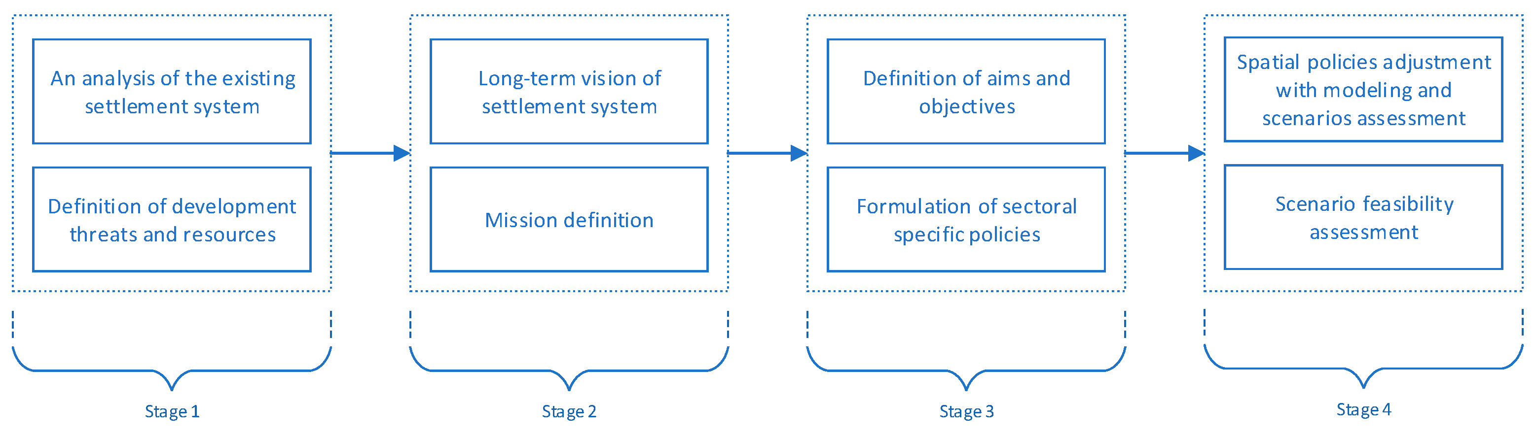
The overall research methodology includes four main stages: (i) data collection and analysis, (ii) generating the concept of an informational model, (iii) formulating the information database model, and (iv) scenario assessment. The research methods were based on the complex and interdisciplinary approaches and basic research approaches in regional planning and sustainable development, including the system approach, comparative analysis, spatial and mathematical modelling, and factor analysis.
The main research sources were the following: (i) basic and methodological documents (regional strategies for sustainable development; regional plans of spatial development (schemes of territorial arrangement); (ii) actual studies on the research issue; and (iii) reports and recommendations for socio-economic and spatial planning documents at the regional and local level. The information background were data from the National Statistics Committee of Belarus, sectoral participating institutions, additional supporting studies, and public and expert inquiries [40,41]. The algorithm of the research methodology is shown as a flowchart in Figure 2.
The analytic process of the research framework was conveniently classified into four main stages, including the following:
- Stage 1.
- (a) An analysis of the existing settlement system (number of settlements, settlement sizes, settlement density, demographic situation, living environment standards, provision with social, industrial, transport infrastructure, etc.), (b) Definition of development threats (social marginalization, poor living standards, rural-urban movement, agricultural land degradation, environmental challenges, sensitivity to natural and industrial disasters, etc.) and development resources (favorable location, environmental, labor, historical and cultural, balneological resources, etc.).
- Stage 2.
- Long-term vision and mission definition for the settlement system in the region/country economic complex.
- Stage 3.
- Definition of aims and objectives for the mission implementation and formulation of sector-specific policies, including social, economic, and environmental.
- Stage 4.
- (a) Spatial policies adjustment within aims and objectives to be achieved with modeling and development scenarios assessment. (b) Scenario feasibility assessment through the definition of required and available resources.
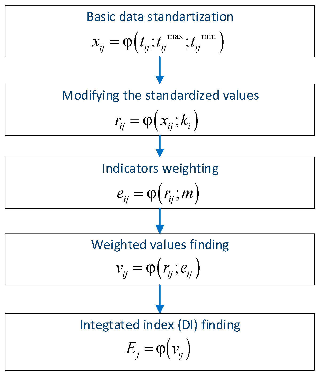
Selecting models for scenario assessment is a topic in its own right. For the purposes of this study we decided to use the multidimensional analysis method. The matter of topical interest is indicators weighting, which is a clear problem due to the lack of a universally accepted weighting procedure. Resent research proposed the use of both expert and non-expert approaches, as well as assigning them equal importance. For the purpose of the research, we used the entropy method; the overall assessment algorithm is shown in Figure 3. We used two taxonomy variables to classify settlements by development level: geometric mean and standard deviation. A more detailed mathematical model is given in our previous research [42].
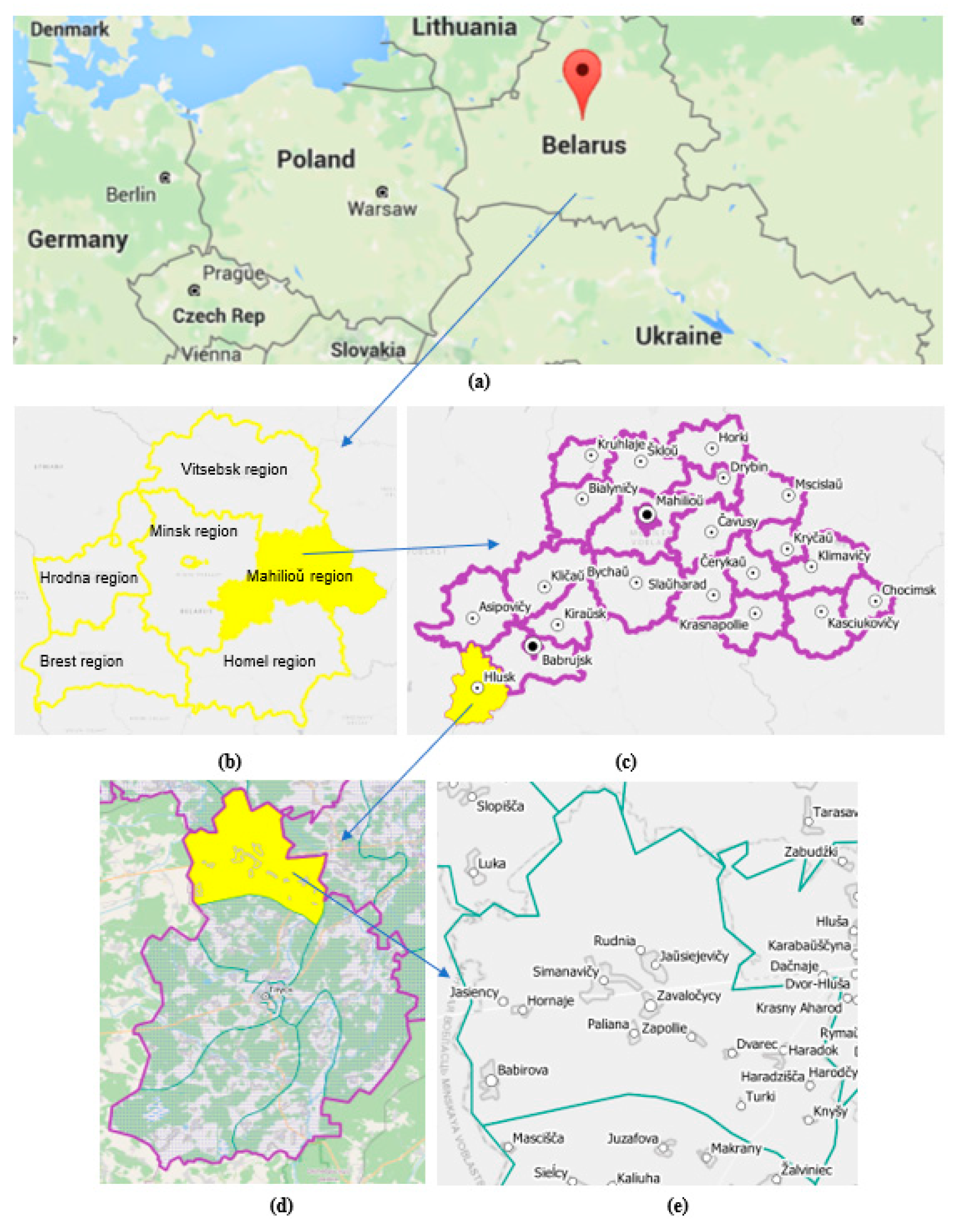
2.2. Reseach Area
The research area was the Zavaločycy local council as a rural settlement system at a local planning level. The council is located in the Hlusk district, Mahilioŭ oblast, Belarus (Figure 4). There are 14 rural settlements (1 agro-town and 13 villages), with a total population of 960 people within the council area. The council center—Zavalocycy agro-town—is located at a distance of 23 km from a district center—Glusk town. The average settlement population is 69 people. The average settlement-pair distance is 4.0 km. The total settlement road length is 35.05 km, including 21.03 km of improved roads.
The industrial infrastructure of the Zavaločycy local council is presented by several enterprises, including an agricultural facility, the Hlusk OJSC Experimental Station, manufacturing facilities, the Zavalocycy and Gorodok forestry sections, and the Cosmos children’s medical rehabilitation unit. The housing resources comprise mainly separate single-story houses in villages and multi-family residential buildings (in the Zavalocycy agro-town). The main entities of social infrastructure are (a) educational facilities (the Zavalocycy State Educational Institution Childcare Center and a secondary school); (b) health care facilities, including two rural outpatient clinics located in the Zavalocycy agro-town and the Babirava village; shopping facilities are represented by two department stores in the Zavalocycy agro-town and the Gorodok village, and two private stores in the Zavalocycy agro-town and the Babirava village. The significant object of cultural heritage is the Zhilinsky–Gatovsky country estate in the Zavalocycy agro-town. Although the estate is not included on the State List of Historical and Cultural Values of Belarus, it has a tourism potential due to its historical importance. Besides, cultural heritage is the most valuable resource for social, cultural, and economic development reflecting the cultural traditions of a village/region.
3. Results and Discussion
3.1. SWOT Analysis
SWOT analysis is considered to be one of the main tools for strategic analysis for municipalities and rural areas. This method allows the identification of the strengths and weaknesses of the research object and the identification of opportunities and threats. As a result, we determine the main problems and directions of sustainable development required to implement strategic development programs.
To assess the current situation, we present a SWOT analysis of the Zavalocycy local council (Hlusk district of the Mahiljow region). There were three main dimensions to be analyzed, including the following: (i) the resource availability pool (land quality, land use categories, and human potential); (ii) the current socioeconomic situation; (iii) the current and possible business dimensions. According to the latest data, the population has decreased markedly; this is due to internal and external population migration. On the other hand, the Zavalocycy local council has sufficient resources for sustainable development. Table 1 illustrates the SWOT Analysis of the Zavalocycy local council.
Thus, the analysis shows that the Zavalocycy local council has a sufficiently high potential for sustainable development, primarily due to its agro-industrial complex, and natural and heritage resources. It is expected that the implementation of a development strategy will lead to new job formation, as well as revenue-enhancement. The economic growth of the council is weak, particularly in local business development, agri-food industry support, consumer services, and encouragement of private farm holdings.
The long-term vision of the Zavalocycy local council involves creating a favorable environment in the Zavalocycy local council for small businesses, the travel industry, and the support of social and living standards (the number and quality of business structures has increased, ensuring a positive effect on economic and social processes in the council; an effective system of additional education, health, and social care has also been created). The council area boasts tourism appeal and a good recreational infrastructure.
3.2. Determinants of Rural Development
Due to the RSS complexity, it has been necessary to classify its key sustainability aspects. Currently, there is no unified typology for settlement development assessment/monitoring. Recent studies and practices provide a variety of structural typologies in regional planning according to the research objective. The classification structure of rural areas in Serbia involves employment, demographic capacity, land-use intensity, and population characteristics [43]. The study [44] focuses on the economic and tourist feature’s demographic and socioeconomic characteristics, agriculture, and food variables.
It should be noted that most of the existing assessment models for rural development involve a wide range of indicators in social, economic, environmental, infrastructural, demographic, and administrative areas [45]. Such an approach requires the involvement of appropriately qualified specialists. Our study covers the issues of area planning in consideration with the sustainable development concept.
It appears to us that the most relevant practice of strategy planning belongs to Poland. Poland has a well-coordinated strategy planning system which covers the issues of human and social capital, innovation and economic efficiency, transport infrastructure, energy security and the environment, regional development, sustainable development of rural areas, the agriculture and fishing industry, and efficient state and national security. The main principles of regional planning are complexity, multifunctionality, environmental friendliness, energy efficiency and waste minimization, etc. The main monitoring tool, STRATEG system, has a publicly accessible database and contains a comprehensive set of key measures. The system resources enable the analysis and perception of information by using data visualization tools, such as maps, charts, and additional information, including links to the most important documents [46].
This practice of regional development is extremely important for Belarus for several reasons. First, we observed the fact that the countries shared a history and the similarity of settlement structures. Development strategies in Poland are developed at the local planning level for rural communes, which corresponds to the village councils in Belarus. Second, Poland followed the unique path from socialism to democracy, with a positive effect on a spatial development. Therefore, it can be safely said that Poland’s development practices are applicable for Belarus as a country which is currently heading down a similar path.
The narrowness of methodological background in the issue of rural development allows us to refer, as well, to the best practices in urban studies. In view of this, we resort to the smart city concept. One of the best practices for issue belongs to Israel. Exemplarily, the strategic plan for Tel Aviv–Yafo includes four main strategic dimensions: (1) a metropolitan and national economic and cultural center and a global city; (2) a city for all its residents; (3) a dynamic, sharing, and autonomous municipal government; (4) an appealing urban environment. The concept of the Tel Aviv–Yafo smart city covers the following areas: community and sports, education, environment and energy, health and welfare, city partners, planning and building, security and emergencies, online services, startup city, and transport and parking [47,48].
Actual RSSD in Belarus cover several main subjects, as follows: (1) healthy environment and sustainable use of natural resources, (2) living standards, welfare, and development inclusion, (3) digitalizing and greening the economy and business development, (4) sustainable development of rural areas and small towns, (5) green urban planning and sustainable consumption, (6) education for sustainable future generations, and (7) social participation in sustainable development. Successful RSSD implementation focuses on key development dimensions including (i) greening of regional planning, (ii) smart management, (iii) location-sensitive development, and (iv) multi-stakeholder engagement. In actual practice, ensuring the stakeholder relations in developing and implementing strategic documents is quite problematic in Belarus [49].
On the other hand, the information model complies with the smart village concept that combines both tools and processes for monitoring rural development. The smart village resources were defined as [13]: social, financial, physical, and informational. The system model of the smart village involves the strategic subsystem, the social subsystem, the economic subsystem, the resource and environment subsystem, and the information subsystem [50,51]. The conceptual model of a rural settlement system includes four subsystems: population, infrastructure, manufacturing, and environment/heritage. Each of subsystems involves a set of components, as shown in Figure 5. The main development trends were identified for RSS sustainability: advances in ICT, providing the most comfortable living and working environment, improving social, engineering and transport infrastructures, and tourism support.
Taking all these points together, and specifically, the SWOT analysis, we have defined five basic strategic lines considering all the available resources of the council: social, technological, economic, environmental, and political. The analysis revealed that those actual approaches can be applied to other planning entities, such as regions and local councils. As a result, a structure for regional planning was obtained (Table 2). It becomes evident that information data is necessary to solve regional planning issues, which determines the relevance and practical significance of the study [52,53].
A set of sub-components was defined through the analysis of regional planning goals. The obtained conceptual framework of RSS includes a wide range of components, such as social, technological, economic, ecological, and political, as shown in Figure 6. The social dimension includes such factors as mindset, cultural sensitivity, and basic values, as well as living standards, and changes in welfare and household budgets. The technological dimension shows the influence of state policy for technologies and innovations, changes in ICT-technologies, and the readiness of businesses, citizens, and infrastructures for energy-efficient technologies. The economic dimension ensures the overall state of the economy and economic growth prospects, the unemployment rate, and changes in financial position. The Environmental dimension defines the impact of business, survival, and transport activities on environmental sustainability or investment, as well as residential attractiveness due to the environmental condition. The policy dimension includes general trends of state/regional policy, the level of state/regional political stability, and legal changes.
The obtained model involves a set of diagnostic features as a basis for formulating the indicators, using five components to explain sustainable rural development, as shown in Table 3.
3.3. Monitoring of Rural Settlement Development
The information model as a tool for systematic data collection and transformation in spatially oriented information-systems involves quantitative and geographical parameters and can be represented in the form of GIS for regional planning in Belarus. We used the model for the developmental monitoring of comparable entities at a local planning level. Monitoring included two main stages: (i) basic indicators and variables definition, (ii) development assessment using the entropy method.
In accordance with the Section 3.2, five indicators of the 1st level were selected: social X1, technological X2, economic X3, environmental X4, political X5, and 10 indexes of the 2nd level: social capital index X11, social services index X12, transport and engineering infrastructure index X21, ICT environment index X22, business environment index X31, labor balance index X32, natural resources index X41, heritage index X42, policy efficiency index X51, and public services index X52. The significance of the 1st level indicators was determined in accordance with the algorithm shown in Figure 3. We used two taxonomy variables to classify settlements by development level: geometric mean and standard deviation. Table 4 shows the assessment results.
The obtained DI values vary from the lowest (DI = 33.69) to highest levels (DI = 68.42). The agro-town of Zavaločycy has the highest development level, while the village of Haradzisca has the lowest one. The majority of settlements (12 entities) exhibit average and below average levels.
Our previous studies showed that the most important aspects of rural development are transport, engineering infrastructure, and ICT environment [46]. For the study aim, we have changed the values of basic indicators of the above-mentioned indicators for Babirova village as the most populated entity. Results of the assessment are shown in Table 3. The DI value for the Babirova village increased from 44.8 to 56.1, changing the development level to high.
The research results show that the obtained model is a new methodology which provides the results objectivity and is of practical value for use due to its flexibility. The practical significance of the study is its applicability in the development/assessment of documents at the local planning level, which is essential in an efficient local governance. Moreover, the model’s significant feature is its multifunctionality, which ensures the possibility of development assessment at any planning level. Such a feature enables the setting of priority growth directions and the formulation of sustainability practices for a rural settlement system and its elements.
4. Conclusions
The study aim was to extend current knowledge within the development of the information model of sustainable rural development. The model provides formulation and assessment of the settlement scenarios for solving the issues of sustainable rural development, ensuring a transition from traditional management forms to a strategic planning system. Such an approach, linking different programs and policies, is an important advantage of the development strategy formulation process. The findings confirmed the validity of the research hypothesis and showed the relevance of the information model as a tool for both the analysis and assessment of settlement system development. The research results showed that the informational model is an effective tool for monitoring sustainable development at a local planning level.
Critical enablers for implementing the state sustainability are effectively implement-ed strategic documents. The strategy should not only focus on economic development, but should also consider issues of social, environmental, political, and other dimensions, and define a single set of documents for socio-economic and territorial planning, which are developed on a common methodological basis in order to ensure the consistency and hierarchical interconnection of the elements of the strategic planning system.
We cannot expect current planning documents in Belarus as a common, unified, and coherent system. Current planning documents in Belarus do not fully match best practices. There are two basic documents at the national level, including the national strategy of sustainable development and the national comprehensive scheme of spatial planning. The relevant regional planning documents are the comprehensive schemes of spatial planning and the strategies of sustainable development. The local planning level is represented by the comprehensive schemes of spatial planning. Strategies of sustainable development for districts are currently under development. The primary units of spatial planning do not have any planning documents, with exception of several districts, including Hlusk district, where socio-economic documents have been developed for each local council. However, we cannot expect such a document to function as a strategic plan due its content, which reflects some current characteristics of a settlement system (social, economic, and infrastructural).
The obtained IM concept involves five main subsystems. The social environment includes aspects of special features of mentality, culture pattern, basic values, requirements for living standards, and changes in wealth and living structure. The technological environment reflects the influences of technologic policy, sectoral innovation technologies, changes in information and communications technologies, and the readiness of business, society and infrastructure communities for energy efficiency technologies. The economic environment includes basics in regional economy and economic growth prospects, the unemployment rate, trends in financial statements, and changes in external costs. The political environment reflects general trends in regional policy, political stability standards in a region, legislation revision in local government, and taxes and utility rates. Moreover, IM provides spatial, physical/technical, socioeconomic, political/managerial, and ecological information and may be a basis for a smart settlement platform that reflects the regional strategy of sustainable development, including smart specialization and development digitalization. Consequently, the proposed model has a potential to be an effective tool for spatial planning and can be a basis for the development of planning documents to assess the sustainability and the management efficiency at the local planning level. To further our study, we plan to extend the research approach by formulation the IM for sustainable regional development and validate it for various districts in Belarus.
Finally, a number of potential limitations need to be considered. First, the inclusive state policy is critical in solving the sustainable development issues and should be focused on strengthening the role of local government authorities while the offering all the necessary resources. Unfortunately, ensuring sustainable development is quite difficult in countries that have the direct government system, including local authorities without the appropriate powers. It should be added that the process of developing planning documents is actually closed for most of stakeholders in Belarus (residents, business, third sector organizations). The core of the problem is an inadequacy of local governments and the political system as a whole. For example, public hearings of local planning documents have a formal approach, and they are conducted after the document development. Therefore, there is a need for political renewal, such as power devolution to local authorities, coupled with the development of new methodological documents for spatial planning.
Author Contributions
Conceptualization, A.H. and L.G.; methodology, A.H. and L.G.; software, A.H.; validation, A.H. and L.G.; formal analysis, A.H.; investigation, A.H. and L.G.; resources, A.H.; data curation, A.H.; writing—original draft preparation, A.H.; writing—review and editing, L.G.; visualization, A.H.; supervision, A.H.; project administration, A.H.; funding acquisition, A.H. and L.G. All authors have read and agreed to the published version of the manuscript.
Funding
This research received no external funding.
Institutional Review Board Statement
Not applicable.
Informed Consent Statement
Not applicable.
Data Availability Statement
Not applicable.
Acknowledgments
The authors are very grateful to the academic editors and anonymous reviewers for constructive comments and suggestions, thanks to whom the article received its final shape.
Conflicts of Interest
The authors declare no conflict of interest.
References
- Krčílková, Š.; Janovská, V. Land Tenure as a Factor Underlying Agricultural Landscape Changes in Europe: A Review. Sci. Agric. Bohem. 2016, 47, 68–81. [Google Scholar] [CrossRef] [Green Version]
- Prevolšek, B.; Maksimović, A.; Puška, A.; Pažek, K.; Žibert, M.; Rozman, Č. Sustainable Development of Ethno-Villages in Bosnia and Herzegovina—A Multi Criteria Assessment. Sustainability 2020, 12, 1399. [Google Scholar] [CrossRef] [Green Version]
- Vetrova, N.M.; Ivanenko, T.A.; Sadykova, G.E.; Sudjeva, D.V. On the Assessment of the Environmental Ecological State in Coastal Cities. In IOP Conference Series: Materials Science and Engineering; IOP Publishing: Bristol, UK, 2020; Volume 913, p. 05203. [Google Scholar] [CrossRef]
- Klóska, R.; Ociepa-Kicińska, E.; Czyżycki, R.; Szklarz, P. Regional Development in Poland in Taxonomic Terms. Sustainability 2020, 12, 4780. [Google Scholar] [CrossRef]
- Perkova, M.V. A Method for Identifying and Resolving Conflicts in Urban Riverside Development. In IOP Conference Series: Materials Science and Engineering; IOP Publishing: Bristol, UK, 2020; Volume 459, p. 052024. [Google Scholar] [CrossRef]
- Gertsberg, L. Sustainable Spatial Development Strategy 2030: From Scientific Evidence to Implementation. Academia. Archit. Constr. 2021, 4, 5–12. [Google Scholar] [CrossRef]
- Gorbenkova, E.; Shcherbina, E. Historical-Genetic Features in Rural Settlement System: A Case Study from Mogilev District (Mogilev Oblast, Belarus). Land 2020, 9, 165. [Google Scholar] [CrossRef]
- Zheng, J.; Na, L.; Liu, B.; Zhang, T.; Wang, H. An Ecological Service System Based Study on Suburban Rural Landscape Multifunction. Land 2021, 10, 232. [Google Scholar] [CrossRef]
- Kogut-Jaworska, M.; Ociepa-Kicińska, E. Smart Specialisation as a Strategy for Implementing the Regional Innovation Development Policy—Poland Case Study. Sustainability 2020, 12, 7986. [Google Scholar] [CrossRef]
- Dziembała, M.; Talar, S. The role of ICT in smart specialization of EU regions. J. Bus. Econ. Manag. 2021, 22, 1512–1530. [Google Scholar] [CrossRef]
- Stanny, M.; Komorowski, Ł.; Rosner, A. The Socio-Economic Heterogeneity of Rural Areas: Towards a Rural Typology of Poland. Energies 2021, 14, 5030. [Google Scholar] [CrossRef]
- Wilkosz-Mamcarczyk, M.; Olczak, B.; Prus, B. Urban Features in Rural Landscape: A Case Study of the Municipality of Skawina. Sustainability 2020, 12, 4638. [Google Scholar] [CrossRef]
- Salvia, R.; Halbac-Cotoara-Zamfir, R.; Cividino, S.; Salvati, L.; Quaranta, G. From Rural Spaces to Peri-Urban Districts: Metropolitan Growth, Sparse Settlements and Demographic Dynamics in a Mediterranean Region. Land 2020, 9, 200. [Google Scholar] [CrossRef]
- Źróbek-Różańska, A. Enclaves of Isolation and Neglect in Rural Areas. Evidence from North-Eastern Poland. Land 2020, 9, 215. [Google Scholar] [CrossRef]
- Kalinowski, S.; Rosa, A. Sustainable development and the problems of rural poverty and social exclusion in the EU countries. Eur. Res. Stud. J. 2021, 24, 438–463. [Google Scholar] [CrossRef]
- Kalinowski, S.; Łuczak, A.; Koziolek, A. The Social Dimension of Security: The Dichotomy of Respondents’ Perceptions during the COVID-19 Pandemic. Sustainability 2022, 14, 1363. [Google Scholar] [CrossRef]
- Kalinowski, S.; Komorowski, Ł.; Rosa, A. Koncepcja Smart Villages. Przykłady z Polski, Wyd; IRWiR PAN, Grupa Cogito: Warszawa, Poland, 2021; ISBN 978-83-89900-62-3. [Google Scholar] [CrossRef]
- Wasser, N.-M.; Ruhstorfer, P.; Kurzrock, B.-M. Advancing Revolving Funds for the Sustainable Development of Rural Regions. Sustainability 2020, 12, 8455. [Google Scholar] [CrossRef]
- Rosner, A.; Wesołowska, M. Deagrarianisation of the Economic Structure and the Evolution of Rural Settlement Patterns in Poland. Land 2020, 9, 523. [Google Scholar] [CrossRef]
- Ślusarz, G.; Gołębiewska, B.; Cierpiał-Wolan, M.; Twaróg, D.; Gołębiewski, J.; Wójcik, S. The Role of Agriculture and Rural Areas in the Development of Autonomous Energy Regions in Poland. Energies 2021, 14, 4033. [Google Scholar] [CrossRef]
- Halamska, M.; Stanny, M. Temporal and spatial diversification of rural social structure: The case of Poland. Sociol. Rural. 2021, 61, 578–601. [Google Scholar] [CrossRef]
- Stych, P.; Kabrda, J.; Bicik, I.; Lastovicka, J. Regional Differentiation of Long-Term Land Use Changes: A Case Study of Czechia. Land 2019, 8, 165. [Google Scholar] [CrossRef] [Green Version]
- Antonić, B.; Djukić, A. Environmentally-Friendly Planning for Urban Shrinkage. In IOP Conference Series: Materials Science and Engineering; IOP Publishing: Bristol, UK, 2020; Volume 410, p. 012084. [Google Scholar] [CrossRef]
- Cárdenas Alonso, G.; Nieto Masot, A. Towards Rural Sustainable Development? Contributions of the EAFRD 2007–2013 in Low Demographic Density Territories: The Case of Extremadura (SW Spain). Sustainability 2017, 9, 1173. [Google Scholar] [CrossRef] [Green Version]
- Alonso, G.C.; Masot, A.N. Rural Space Governance in Extremadura (SW Spain). Analysis of the Leader Approach. Eur. Countrys. 2020, 12, 448–468. [Google Scholar] [CrossRef]
- Agnoletti, M.; Emanueli, F.; Corrieri, F.; Venturi, M.; Santoro, A. Monitoring Traditional Rural Landscapes. The Case of Italy. Sustainability 2019, 11, 6107. [Google Scholar] [CrossRef] [Green Version]
- Fernández Martínez, P.; De Castro-Pardo, M.; Barroso, V.M.; Azevedo, J.C. Assessing Sustainable Rural Development Based on Ecosystem Services Vulnerability. Land 2020, 9, 222. [Google Scholar] [CrossRef]
- Ortiz-Báez, P.; Cabrera-Barona, P.; Bogaert, J. Characterizing landscape patterns in urban-rural interfaces. J. Urban. Manag. 2021, 10, 46–56. [Google Scholar] [CrossRef]
- Zulauf, K.; Wagner, R. Urban and Rural Sustainability: Divergent Concepts and Their Consequences for Marketing. Front. Sustain. Food Syst. 2021, 2, 670866. [Google Scholar] [CrossRef]
- Egidi, G.; Halbac-Cotoara-Zamfir, R.; Cividino, S.; Quaranta, G.; Salvati, L.; Colantoni, A. Rural in Town: Traditional Agriculture, Population Trends, and Long-Term Urban Expansion in Metropolitan Rome. Land 2020, 9, 53. [Google Scholar] [CrossRef] [Green Version]
- Jaszczak, A.; Vaznoniene, G.; Kristianova, K.; Atkociuniene, V. Social and Spatial Relation between Small Towns and Villages in Peripheral Regions: Evidence from Lithuania, Poland and Slovakia. Eur. Countrys. 2021, 13, 242–266. [Google Scholar] [CrossRef]
- Prus, P.; Sikora, M. The Impact of Transport Infrastructure on the Sustainable Development of the Region—Case Study. Agriculture 2021, 11, 279. [Google Scholar] [CrossRef]
- Yang, F.; Chi, G.; Wang, G.; Tang, S.; Li, Y.; Ju, C. Untangle the Complex Stakeholder Relationships in Rural Settlement Consolidation in China: A Social Network Approach. Land 2020, 9, 210. [Google Scholar] [CrossRef]
- Gupta, R. Identification of Suitable Rural Development Indicators. Dev. Sanskriti Interdiscip. Int. J. 2022, 19, 11–22. [Google Scholar] [CrossRef]
- Górecka, A.; Jezic, Z.; Kardum, B. Smart villages and rural development. Acta Sci. Pol. Oeconomia 2021, 20, 39–46. [Google Scholar] [CrossRef]
- Krzysztofik, R.; Kantor-Pietraga, I.; Spórna, T. Spatial and functional dimensions of the COVID-19 epidemic in Poland. Eurasian Geogr. Econ. 2020, 61, 573–586. [Google Scholar] [CrossRef]
- Egidi, G.; Zambon, I.; Tombolin, I.; Salvati, L.; Cividino, S.; Seifollahi-Aghmiuni, S.; Kalantari, Z. Unraveling Latent Aspects of Urban Expansion: Desertification Risk Reveals More. Int. J. Environ. Res. Public Health 2020, 17, 4001. [Google Scholar] [CrossRef] [PubMed]
- Jabareen, Y.; Eizenberg, E. The failure of urban forms under the COVID-19 epidemic: Towards a more just urbanism. Town Plan. Rev. 2021, 92, 57–63. [Google Scholar] [CrossRef]
- Sánchez, M.S.-O.; Castro-Serrano, J.; Robina-Ramírez, R. Stakeholders’ Participation in Sustainable Tourism Planning for a Rural Region: Extremadura Case Study (Spain). Land 2021, 10, 553. [Google Scholar] [CrossRef]
- National Statistical Committee of the Republic of Belarus. Available online: https://www.belstat.gov.by/en/ (accessed on 1 February 2022).
- Glussky District Executive Committee. Available online: http://glusk.gov.by/ (accessed on 1 February 2022).
- Harbiankova, A.; Scherbina, E. Evaluation Model for Sustainable Development of Settlement System. Sustainability 2021, 13, 11778. [Google Scholar] [CrossRef]
- Gajić, A.; Krunić, N.; Protić, B. Classification of Rural Areas in Serbia: Framework and Implications for Spatial Planning. Sustainability 2021, 13, 1596. [Google Scholar] [CrossRef]
- Basile, G.; Cavallo, A. Rural Identity, Authenticity, and Sustainability in Italian Inner Areas. Sustainability 2020, 12, 1272. [Google Scholar] [CrossRef] [Green Version]
- Targeting Policies to Place: A Jurisdictional Analysis of Composite Indicators for Rural Development. Available online: https://www.researchgate.net/publication/360087969_Targeting_Policies_to_Place_A_Jurisdictional_Analysis_Of_Composite_Indicators_for_Rural_Development (accessed on 10 May 2022).
- STRATEG. Available online: https://strateg.stat.gov.pl/#/ (accessed on 15 March 2022).
- Gertsberg, L. Strategic or Master Plan? Acad. Archit. Constr. 2022, 1, 60–67. [Google Scholar] [CrossRef]
- Tel Aviv-Yafo A Smart City. Available online: https://www.tel-aviv.gov.il/About/Pages/smartcity.aspx (accessed on 10 March 2022).
- Regional Strategy of Sustainable Development. Available online: https://mogilev-region.gov.by/files/_mogoblsur_14.12.2020_sc9_fin_1.pdf (accessed on 15 March 2022).
- Zhang, X.; Zhang, Z. How Do Smart Villages Become a Way to Achieve Sustainable Development in Rural Areas? Smart Village Planning and Practices in China. Sustainability 2020, 12, 10510. [Google Scholar] [CrossRef]
- Danilina, N.V.; Privezentseva, S.V. Smart Space Solutions of Pedestrian Ways in Public Transport Transit Hubs. In IOP Conference Series: Materials Science and Engineering; IOP Publishing: Bristol, UK, 2020; Volume 775, Available online: https://0-iopscience-iop-org.brum.beds.ac.uk/article/10.1088/1757-899X/775/1/012008 (accessed on 15 March 2022). [CrossRef] [Green Version]
- Shcherbina, E.; Gorbenkova, E. Factors Influencing the Rural Settlement Development. IFAC-PapersOnLine 2019, 52, 231–235. [Google Scholar] [CrossRef]
- Shcherbina, E.V.; Al-Qatrany, A.S.D.; Slepnev, M.A. Land use information model to ensure balanced development for territories of Basra governorate. Biosph. Compat. Hum. Reg. Technol. 2021, 1, 51–62. [Google Scholar] [CrossRef]
Figure 1.
Belarus Planning System. Source: Own Work.

Figure 2.
The algorithm of the research methodology. Source: Own Work.

Figure 3.
The algorithm DI finding. Source: Own Work.

Figure 4.
Location of the Zavaločycy local council. Source: Own Work. (a) Belarus location, (b) Mahiliou region location, (c) Hlusk district location, (d) Zavaločycy local council location, (e) Zavaločycy local council map.
Figure 4.
Location of the Zavaločycy local council. Source: Own Work. (a) Belarus location, (b) Mahiliou region location, (c) Hlusk district location, (d) Zavaločycy local council location, (e) Zavaločycy local council map.

Figure 5.
Conceptual Data Model for Rural Settlement System. Source: Own Work.

Figure 6.
Preliminary Conceptual Framework of RSS.


Table 1.
SWOT Analysis of the Zavalocycy local council.
| Strengths | Weakness |
| 1. Availability of land resources for both agricultural industry and private farm holdings. | 1. Lack of transport accessibility. |
| 2. Environmentally friendly conditions. | 2. Lack of public business activities. |
| 3. Enterprises for agricultural products processing. | 3. Migration outflow. |
| 4. Availability of investible territories for industrial and residential development. | 4. Regressive age distribution. |
| 5. High level of ICT. | 5. Sparsely populated areas. |
| 6. Advantageous geographical location. | 6. Lack of own financial resources. |
| 7. Raw material capacity. | 7. Insufficient budget financing. |
| 8. Rich cultural and historical heritage. | 8. Isolated location. |
| 9. Implementation of social and planning programs for rural areas. | 9. Business insecurity. |
| Opportunities | Threats |
| 1. Adoption of energy-efficient technologies. | 1. Depopulation. |
| 2. Availability of unused land resources. | 2. Growth in outward migration of skilled labor forces. |
| 3. Actual technologies in agriculture. | 3. Rise in unemployment levels. |
| 4. Partnerships within the Hlusk district. | 4. Production decrease in private farm holdings. |
| 5. Service industry development. | 5. Decline of trust in authorities. |
| 6. Social infrastructure development. | 6. Budget deficit growth. |
| 7. Development of private farm holdings, including mini-processing enterprises as a source of personal income. | |
| 8. Heritage tourism. |
Table 2.
Problems structure for spatial planning.
| Processes in RSS | Spatial Planning Goals |
|---|---|
| Social | Improving the quality and accessibility of public services. Strengthening the regional human and social capital. Promoting social inclusion, combating poverty, and ending discrimination. Investing in education, instruction, and vocational training for skills and lifelong learning. |
| Technological | Strengthening the spatial cohesion of the region. Strengthening research, technological development, and innovation Enhancing access, use, and quality of information and communication technologies. Promoting sustainable transport and removing bottlenecks in key network infrastructures. |
| Economic | Effective use of the economic potential of the region. Promoting sustainable and quality employment and supporting labor mobility. Enhancing the competitiveness of enterprises and the agricultural sector. |
| Environmental | Responsible use of resources and protection of the natural environment and cultural heritage. Supporting the shift towards a low-carbon economy. Promoting climate change adaptation, risk prevention, and management. Preserving and protecting the environment and promoting resource efficiency. Reducing the environmental impact of human processes and economic development, as well as regional adaptation to climate change. |
| Political | Strengthening public administration. Enhancing institutional capacity of public authorities and stakeholders and developing efficient public administration. Creating attractive housing and investment conditions. Determining conditions and possibilities for solving administrative/managerial issues, including the quality and implementation of tools for managerial decisions. |
Table 3.
List of indicators for monitoring rural settlement development.
| Index | Indicator | Median |
|---|---|---|
| Social capital | Population amount | 71.60 |
| Percentage of seniors | 48.86 | |
| Young-to-old-population ratio | 0.17 | |
| Social services | Time needed to reach a social facility, min | 8.00 |
| Number of social facilities | 0.71 | |
| Transport and engineering environment | Transport environment accessibility | 6.90 |
| Engineering environment availability | 1.00 | |
| ICT environment | Number of households with data networks | 35.70 |
| Total number of households | 37.30 | |
| Business environment | Number of farm households | 0.14 |
| Economic diversity | 1.07 | |
| Labor balance | Active working-age percentage | 45.48 |
| Time needed to reach a work location, min | 8.00 | |
| Natural resources | Recreational areas, percentage | 64.50 |
| Recreational areas, availability | 1.93 | |
| Heritage | Number of heritage objects | 0.14 |
| Heritage objects availability | 0.12 | |
| Policy efficiency | Availability of local spatial development plan | 1.00 |
| Administrative status | 1.07 | |
| Public services | E-accessibility of public services | 1.02 |
| Availability of multi-purpose public service center | 1.14 |
Table 4.
Monitoring Results for Local Settlement System (Zavalocycy Local Council). Source: Own Work.
Table 4.
Monitoring Results for Local Settlement System (Zavalocycy Local Council). Source: Own Work.
| Settlement Unit | Scenario I | Settlement Unit | Scenario II | ||||
|---|---|---|---|---|---|---|---|
| DI LSS | DI LSS Value Limits | Development Level | DI LSS | DI LSS Value Limits | Development Level | ||
| Zavalocycy | 71.3 | >62.73 | Highest | Zavalocycy | 76.1 | >62.73 | Highest |
| Haradok | 47.4 | 42.95–52.84 | Average | Babirova | 56.1 | 52.84–62.73 | High |
| Simanavicy | 47.3 | Haradok | 47.4 | 42.95–52.84 | Average | ||
| Zapollie | 46.3 | Simanavicy | 47.3 | ||||
| Hornaje | 45.0 | Zapollie | 46.3 | ||||
| Babirova | 44.8 | Hornaje | 45.0 | ||||
| Paliana | 43.5 | Paliana | 43.5 | ||||
| Jausiejevicy | 43.0 | Jausiejevicy | 43.0 | ||||
| Dvarec | 41.9 | 33.06–42.95 | Below average | Dvarec | 41.9 | 33.06–42.95 | Below average |
| Jasiency | 41.9 | Jasiency | 41.9 | ||||
| Knysy | 40.6 | Knysy | 40.6 | ||||
| Rudnia | 39.9 | Rudnia | 39.9 | ||||
| Turki | 39.9 | Turki | 39.9 | ||||
| Haradzisca | 23.0 | <23.17 | Lowest | Haradzisca | 23.0 | <23.17 | Lowest |
Publisher’s Note: MDPI stays neutral with regard to jurisdictional claims in published maps and institutional affiliations. |
© 2022 by the authors. Licensee MDPI, Basel, Switzerland. This article is an open access article distributed under the terms and conditions of the Creative Commons Attribution (CC BY) license (https://creativecommons.org/licenses/by/4.0/).
Share and Cite
MDPI and ACS Style
Harbiankova, A.; Gertsberg, L. Information Model for Sustainable Rural Development. Energies 2022, 15, 4009. https://0-doi-org.brum.beds.ac.uk/10.3390/en15114009
AMA Style
Harbiankova A, Gertsberg L. Information Model for Sustainable Rural Development. Energies. 2022; 15(11):4009. https://0-doi-org.brum.beds.ac.uk/10.3390/en15114009
Chicago/Turabian StyleHarbiankova, Alena, and Lora Gertsberg. 2022. "Information Model for Sustainable Rural Development" Energies 15, no. 11: 4009. https://0-doi-org.brum.beds.ac.uk/10.3390/en15114009
Note that from the first issue of 2016, this journal uses article numbers instead of page numbers. See further details here.