Article

Determination of Empirical Environmental Indices for the Location of Cemeteries—An Innovative Proposal for Worldwide Use

by
Tania Crisanto-Perrazo
1,*,
Jonathan Guayasamín-Vergara
1,
Eduardo Mayorga-Llerena
2,
Izar Sinde-Gonzalez
1,
Diego Vizuete-Freire
3,
Theofilos Toulkeridis
1,*,
Geomara Flores Gomez
1 and
Greta Fierro-Naranjo
4
1
Department of Earth Sciences and Construction, Universidad de las Fuerzas Armadas ESPE, Av. General Rumiñahui S/N y Ambato, Sangolquí 171103, Ecuador
2
Faculty of Chemical Sciences, Universidad Central del Ecuador, Av. Francisco Viteri and Gato Sobral, Quito 170129, Ecuador
3
Instituto Superior Tecnológico Sucre, Higher Technology in Environmental Management, Av. 10 de Agosto N26-27 y Luis Mosquera Narvaéz, Quito 170129, Ecuador
4
Escuela Politécnica Nacional, Environmental Research and Control Center, Av. Ladrón de Guevara 253, Quito 170525, Ecuador
*
Authors to whom correspondence should be addressed.
Sustainability 2022, 14(10), 6284; https://0-doi-org.brum.beds.ac.uk/10.3390/su14106284
Submission received: 1 April 2022 / Revised: 28 April 2022 / Accepted: 17 May 2022 / Published: 21 May 2022
(This article belongs to the Topic Sustainable Smart Cities and Smart Villages)

Abstract

:
Cemeteries are a source of environmental contamination, as they hold hundreds of human corpses in different stages of decomposition. Therefore, the current research developed a new tool, which is easily applied, to determine the potential environmental contamination generated by current cemeteries within their ecosystems. The linear equations developed, with a number of variables between 10 and 3, allow for obtaining empirical indices to evaluate the suitability of a site, regardless of the geographical area in which it is located, through a variety of sources. In order to obtain the equations and, therefore, the indices, a hierarchy was performed using the Saaty matrix. With such a matrix, different ranges of affectation were established for each variable and relative values were assigned that cover all probabilities quantitatively, from the least probable to the most likely. With the linear equations, three verification runs were conducted, obtaining satisfactory results compared with the location map of cemeteries obtained in previous studies. These equations will constitute a tool of fundamental use for local governments, which will allow for the evaluation of existing cemeteries and use of the methodology described in preliminary analysis, to save resources and have a starting point for an efficient land use plan.

1. Introduction

Worldwide, there is a large number of cemeteries that are located in different areas, without knowing the potential environmental impact on ecosystems or the social impact they can cause [1,2,3,4]. According to data from Worldometer, 2022 [5], there are 7.9 billion people, a population that, when completing the life cycle, has to be disposed of in a suitable place or environment [6,7,8,9].
After a person is deceased and, subsequently, the corresponding body, a series of characteristics typical of the decomposition process are presented, such as cadaveric rigidity, swelling, active and advanced putrefaction, and the remains, the corpse becomes a source of organic matter, whose rate of degradation may reach between five to ten years [9,10], in the presence of adequate environmental conditions, such as the terrain, atmosphere, heat, and humidity [11,12], as well as the influence of scavengers, insects, and decomposing microorganisms [13,14]. According to the chemical composition of the human body, the pollutants released are mainly ammonia and carbon dioxide, although other types of compounds such as sodium, potassium, chlorides, bicarbonates, nitrates, phosphates, ammonium, and sulfate ions are, also, released [2,3,15,16]; in addition, two animal proteins are released that are responsible for the peculiar smell of decomposition, being cadaverine and putrescin, which are contaminants for water and are toxic to humans and other living organisms [17]. Neckel et al., 2017, determined the adverse effects due to the impact of cemeteries because of bacteriological contamination of the groundwater in Brazil [18].
Two centuries ago [19], the piling up of corpses was not considered a contamination problem, since neither the conditions nor the environment where they were dumped were analyzed [20,21]. Spongberg and Becks determined elevated concentrations of Fe, Pb, Cu, Zn, Co, and As, associated with current and past burial practices, which can accumulate deep in cemeteries [22]. A second study of soil contamination in China and Nigeria confirmed that soils associated with coffins featuring painted metal trim or processed wood yielded an increase in trace metals [23]. Neckel et al. encountered elevated concentrations of Cu, Zn, Fe, Mn, Pb, and Cr in three cemeteries in Brazil, when compared to sites outside the study area [24].
In many countries, the mishandling of human corpses has presented a serious problem [18,20,24,25]; in addition to poor location due to the geotopography of cemeteries, lack of available land, unsuitable soils, irregular topography, and little depth in the water table, these constructions are a potential risk factor for surface waters and, therefore, for health [26]. These facts not only represent a danger for the people who handle them directly [27,28], but also they can contaminate the soil and water in the areas of direct influence in the final disposal phase [7,19,29,30,31,32,33,34,35,36,37], due to the chemicals that are immediately released by the decomposition of the corpse [26] as well as those used for its conservation. Therefore, cemeteries are considered as a particular type of landfill [6], in which traceable columns of indicator bacteria suggest that microbiological decomposition products can reach the groundwater by percolation [21,38,39], where contamination is able to cause the affectation of water springs by microorganisms that proliferate in the putrefaction process [38], due to the release of leachates that can cause alterations in underground aquifers [10,17,26,40,41,42,43,44,45]. In addition, there is the disintegration of heavy metals from the destruction of the coffins in which they are disposed [27,36,46]. Therefore, corpses should be considered as waste that needs to be managed in the most appropriate way.
Several studies indicate that unsaturated soils are the main filter that stops the passage of rainwater towards a tomb [7,38,47]. However, favorable environments, in which the hydrogeology of the sector influences the infiltration of the rainwater, produce conditions that allow the transfer of pathogenic organisms to underground sources or alterations to soil chemistry [7,31,32,48] as well as an increase in the concentrations of natural organic or inorganic substances that can cause groundwater to not be usable or drinkable [38,40,41].
Research performed in three cemeteries in Portugal indicated high bacteriological and physical–chemical levels in groundwater, when compared to wells located 300 m away from them [9]. On the other hand, there was evidence of a certain increase in the number of cases of typhoid fever between 1963 and 1967, in people who lived near a cemetery in Berlin, as well as in West Germany. There, the presence of this bacterium was determined to be in concentrations 60 times higher than those found in natural water, detected at 0.5 m from groundwater from the alluvial substrate, whose concentration decreased depending on the depth of sampling [10,49].
A case study conducted in Brazil assessed the monitoring of wells around a cemetery under evaluation, revealing the presence of coliform bacteria, considered an indicator of fecal matter or decomposing meat [43]. In addition, conductivity values of around 700 to 1380 µS/cm were found, typical readings of saline solutions in wastewater [44,45], which may be associated with high levels of calcium, magnesium, and sodium. Additionally, high COD values associated with labile organic compounds, ammoniacal nitrogen, mobile anions, and alkaline earth metals were recorded, determining adverse effects because of the impact of cemeteries, due to bacteriological contamination of groundwater [18,43,47]. Another case study developed in three cemeteries in Carazinho indicated an excess of copper in the cemeteries [24].
Higher mineral compositions are evidenced in a South African cemetery than in sites that are far from it, presenting high concentrations of metals such as B (5.99 mg/kg), Mn (430.66 mg/kg), Ni (440.63 mg/kg), Zn (7.76 mg/kg), Cu (17.39 mg/kg), and As (0.39 mg/kg), which are used in metal ornaments or coffin paints [50]. Likewise, the influence of tombs with multiple burials was evaluated, presenting high concentrations of V (95.29 mg/kg), Cr (608.45 mg/kg), Mn (566.30 mg/kg), Co (62.06 mg/kg), Ni (72.47 mg/kg), and Zn (12.47 mg/kg) [44], concentrations that are able to accumulate deep in cemeteries due to current and past burial practices [12,22,23,34,35].
A further study in Canada [43] and Australia determined the presence of nitrites, nitrates, and phosphates near their cemeteries, in addition to the fact that in the town of Adelaide in Australia the increase in BOD5 and ammonium was evidenced. In other countries, such as southeastern Poland, the presence of nitrates was determined in the rainy season, as well as sulfates, fluorides, and chlorides [29].
In the study performed by Gomez et al. [4], a tendency towards environmental contamination is evidenced, due to cemeteries that are close to bodies of water, with silty-sandy soils and steep slopes. Therefore, the location of cemeteries in suitable areas, in order to generate less impact [9], will depend on both environmental and geographical conditions [11,51,52]. There might be, even, new aspects in the view of paleogeographical interpretation, as the site itself of a cemetery may reveal unknown historical aspects of past strategic areas as one part, and contamination that has occurred through time as a further issue. Contamination is influenced by variables such as the water table and distance from water sources, which have an inverse relationship with contamination, concluding that the deeper the depth is, the lower the contamination [22,41]. Soil texture, directly, influences the transfer of pollutants [22,53], while the slope of the land affects the release of leachate to the closest sub-basin sections [48]. Precipitation and temperature under suitable conditions, such as high humidity and temperatures between 21 and 38 °C, accelerate metabolic reactions for microbiological organisms [13,14]. Population density influences environmental pollution, so cemeteries should be located in areas with a low anthropic level [54,55]. The number of graves and year of operation have, also, a direct relationship with environmental contamination, due to the generation of leachates released into the environment, depending on the number of people buried during the period of operation [52], while a geological fault has an incidence, due to the affectation of pit structures and the generation of possible infiltrations at the phreatic level in unwanted events [52]. All these variables present a potential environmental risk, if they are not properly considered in the evaluation of the location area of a burial center [52], which can be related by means of empirical indices.
Environmental indicators are parameters through which monitoring and quantification, as well as periodic evaluation of environmental variables, can be performed, determining trends and allowing corrections to be generated for continuous improvement. The indicators are, in turn, a technical and scientific information tool, which constitutes a fundamental support in the management and evaluation of sustainability [56,57].
The location proposal for the construction of new cemeteries, in sites with the least possible impact, has been studied by several authors over time, with positive results [58]. Croucamp and Richards generated guidelines for choosing optimal construction sites for new cemeteries in Pretonia [59]. Dian performed a study of the urban location of cemeteries, through a temporal space analysis using the Geography Information System (GIS) tool, in three different time scenarios, based on the land use master plan for a case study in China [60]. Lotfi et al. used the multiple criteria analysis method, called the Analytical Hierarchical Process (AHP), to calculate the weight of factors that affect the decision-making process and, with the help of the GIS tool, the management, standardization, and analysis of spatial and environmental data, for the construction of a cemetery in the city of Sanan-dai in Iran [61]. In Russia and its surroundings, soils have, even, been classified as sites of remains of human cadavers, by the term nekrozems [62,63].
Consequently, the use of an AHP, in conjunction with a GIS tool, is widely used since it allows, through the weighting of influencing factors in decision-making, the superimposition of special layers, in order to create a layer that determines the degree of reasonableness of positions [58,64,65]. This process enables the analysis of a large amount of data and greatly facilitates planning and problem reduction.
Thus, due to the contamination of the environmental matrices of water, air, soil, and biota generated by the release of leachates formed by the decomposition of the corpses [7,15], the materials and chemicals released into the environment [26], and the poor management of this type of waste [26], it is proposed to define, through environmental empirical indices, the most adequate preliminary conditions for the location of final disposal sites in the management of human corpses. The results will constitute an important starting point for updating public policies, standards, and procedures for the treatment of this type of waste, may be used by governments in the inclusion of their land use plans, and will contribute to saving technological and economic resources, as well as time and personnel, which will allow researchers to obtain easily accessible bibliographic data to generate an initial analysis of a site that will be intervened [52].

2. Materials and Methods

We started with the determination of the sample size of a total of 71 cemeteries. Subsequently, the study variables were established by a panel of experts, based on the work of Arcos [51], Guayasamin [52], and Flores [4]. Applying Saaty’s method, the variables were related and ranked, establishing categories for the cemeteries. Finally, the empirical equations for 10 to 3 variables were determined, and, later, they were validated by choosing a cemetery from each category and comparing with Figure 1, obtained from the map algebra.

2.1. Study Area

For the determination of empirical environmental indices for the location of cemeteries, a study area in central Ecuador has been chosen. The zone is located between 2550 and 2886 m above sea level, its temperature is 0 to 24 °C, and its annual precipitation ranges between 500 and 2000 mm [66,67,68].
The current study started with 71 cemeteries located in the central highlands of Ecuador, to which a ranking analysis was applied [4,51,52], in order to determine which of them present the highest probability of generating contamination to the environment. Based on the studies of Arcos 2020 [51] and Guayasamín 2021 [52], three cemeteries were selected for the validation of the given empirical equations. The objective has been to include three scenarios, being best, medium, and worst, in order to confirm the results obtained.
The criteria for choosing the cemeteries were based on previous studies [4,51,52], in which the cemeteries were classified into five zones, being not suitable, slightly suitable, moderately suitable, very adequate, and completely adequate. The Nanegal cemetery is located approximately 74 km away from the capital of Ecuador, Quito, which houses approximately 500 tombs, and it is located in an unsuitable area [4,51,52]. Likewise, the Tumbaco cemetery is located approximately 24 km away from Quito and houses approximately 5,100 graves, being located in a moderately suitable area. Finally, the Calderón cemetery is located 16 km from Quito, where it houses approximately 800 tombs and is located in a completely adequate area.

2.2. Determination of the Hierarchy Analysis through the Saaty Matrix

Starting from the universe proposed by Arcos (2020) [51], of 71 cemeteries, the qualitative and quantitative variables were assessed, discarding distances to the historic center and green areas, since the weights assigned in the Saaty matrix of the Arcos study (2022) are low. Four variables, the water table [22], the distance to a geological fault [52], the number of graves, and the age of the cemetery [52], considered relevant by the panel of experts, were added for the current investigation, which, along with those considered in the first study gave a total of 10, is the maximum number of variables accepted by this method. Subsequently, a paired matrix of judgments was generated, by relating the element in the left column to the element in the top row of the matrix, answering the question, how much more important is the element in the column compared to the element in the row? With this, the degree of importance was established [69], and it was verified that the criteria of reciprocity, homogeneity, and consistency were met [70].
Successively, a priority matrix was developed, which is obtained exactly when the pairwise comparison matrix is raised to high potencies. The answer is approximated by adding each row of the matrix and dividing for its total, until the results obtained do not vary among themselves [46]. A series of coefficients or indices were generated that established the degree of priority for each of the variables proposed [51]. Finally, the calculation of the maximum eigenvector of the paired matrix known as λmax (Equation (1)) was performed, which is generated from the product of the priority matrix and the sum of the columns of the paired comparison matrix [71], the consistency index normal, CI (Equation (2)), and the consistency ratio, CR (Equation (3)). The latter must be less than 10% for validation.
  λ m a x = B W
  C I = λ m a x n n 1
C R = C I R a n d o m   c o n s i s t e n c y   i n d e x
where:
W = priority matrix.
B = matrix of the sum of the elements of each column of the paired comparison matrix.
λmax = maximum eigenvector of the paired matrix, scalar value.
N = number of variables.
CI = normal consistency index.
The random consistency index is obtained from the tables [49].
CR = Consistency Ratio.

2.3. Determination of Empirical Indices

Once the coefficients of the ranking analysis have been obtained through the Saaty matrix [69,70,71], for a total of ten variables, the ranges of affectation are established, according to a bibliographic review and a panel of experts, for each of the variables [51,52]. These were categorized, with a scale of colors and values that range from 1 to 5 depending on the probability of contamination, being Completely Adequate = 1 (Dark Green), Very Adequate = 2 (Light Green), Moderately Adequate = 3 (Yellow), Slightly Adequate = 4 (Orange), and Not Adequate = 5 (Red) [51].
According to the information collected in the laboratory and in the field, as well as with the calculation of consistency determined for the sample size in cemeteries, all the variables considered were added, multiplied by the prioritization values obtained through the Saaty Matrix and through map algebra with the help of a free access GIS, obtaining a new layer, which allowed for differentiation through the relationships of all the variables. With this tool, the cemeteries were determined, which presented a greater degree of importance in the investigation and discriminated those that would not present inconveniences with the selected criteria, differentiating the cemeteries that present a greater probability of generating contamination to the environment and assigning them the color scale described above, whose results were used as comparisons of functionality for the empirical indices, as illustrated in Figure 1.
The information used in the hierarchical analysis was obtained through cartographic maps provided by public institutions in Ecuador, such as the Water Secretariat, the Military Geographic Institute, the Ecuadorian Space Institute, and SIG Tierras.
A relationship was obtained between the initial geographic and environmental conditions, in such a way that the methodology described previously was followed to establish the empirical environmental indices. The number was modified from 10 to 3 variables as listed in Table 1, and linear equations were generated with a maximum of 10 and a minimum of 3 unknowns [52], capable of relating the environmental and geographical conditions to which a cemetery is exposed.
The variables described in Table 1 and represented with letters, prioritize the most relevant environmental and geographical conditions that must be considered, when choosing the disposal site where a new cemetery will be implemented, or through which the evaluation of those already located will be carried out. Thus, flexible empirical formulas were obtained that can be used without the need to initially require physical–chemical parameters, working directly with their environment and with easily accessible information. It is not necessary to have all the variables, to preliminarily determine the conditions in which a cemetery is found and the probability that it will generate contamination. However, the greater the number of variables included, the greater the accuracy is in determining the type of area where a new cemetery would be located.

2.4. Theoretical Validation of Empirical Indices

For the theoretical validation of the empirical indices, a universe of 71 cemeteries was started [51], proceeding to consider three cemeteries located in high (not suitable), medium (slightly suitable), and low (fully suitable) conditions, varying the analysis from 10, 8, and 6 variables and noting that the results are related to the criteria initially determined in this study and to the map obtained (Figure 1), which represents the comparison pattern for all cases.

3. Results

3.1. Hierarchy Analysis through the Saaty Matrix

The categorization scales, determined for each of the variables obtained from bibliographic information and from the analysis of the panel of experts, are detailed in Table 2.
With the criteria detailed in Table 1, the paired matrix of judgments was worked on and, subsequently, the prioritization matrix was obtained. Then, a scale of values (1–5) and colors were generated, which were validated by means of the consistency relation, applying Equations (1)–(3).
λ m a x = 10.3224
C I = 10.3224 10 10 1 = 0.0358
C R = 0.0358 1.49 = 0.0240
0.0240 100 = 2.40 %
2.40   % < 10   %
The results indicate that the judgments determined from the paired matrix are consistent.

3.2. Empirical Indices

The values obtained, after determining the prioritization coefficients for each of the variables, are listed in Table 3.
10 variables
X = 0.2915 A + 0.2126 B + 0.1498 C + 0.1036 D + 0.6987 E + 0.0452 E + 0.0452 F + 0.0292 H + 0.0292 I + 0.0203 J
9 variables
X = 0.3119 A + 0.2206 B + 0.1524 C + 0.1033 D + 0.0683 E + 0.0436 E + 0.0436 F + 0.0282 H + 0.0282 I
8 variables
X = 0.3311 A + 0.2394 B + 0.1551 C + 0.1030 D + 0.0672 E + 0.0427 E + 0.0427 F + 0.0288 H
7 variables
X = 0.3543 A + 0.2392 B + 0.1573 C + 0.1017 D + 0.0650 E + 0.0413 E + 0.0413 F
6 variables
                  X = 0.3825 A + 0.2504 B + 0.1596 C + 0.1006 D + 0.0641 E + 0.0428 E
5 variables
        X = 0.4185 A + 0.2625 B + 0.1599 C + 0.0973 D + 0.0618 E
4 variables
X = 0.4673 A + 0.2772 B + 0.1601 C + 0.0954 D
3 variables
X = 0.5396 A + 0.2970 B + 0.1634 C

3.3. Theoretical Validation of Empirical Indices

For the validation of the method, from the universe of 71 cemeteries, three cemeteries were considered, being Nanegal, Tumbaco, and Calderón, since these represent high (not suitable), medium (slightly suitable), and low (totally suitable) conditions. The first analysis was performed with 10 variables, using the categorization criteria established in Table 2 and Equation (4). The results obtained for the three cemeteries are indicated in Table 4.
Continuing with the validation of the method, we worked with eight and six variables, using the criteria established in Table 3 and Equations (6) and (8), respectively. The results obtained are listed in Table 5 and Table 6.

4. Discussion

The categorization scales, determined by bibliographic analysis and a panel of experts, indicated the best and worst conditions in which a cemetery can be located. In Table 2, where ranges from non-suitable to totally suitable areas are established, an initial evaluation of the study sites was realized for the following variables: water table [22], distance to water sources [41], precipitation [13], slope [48], soil type [22], age of the cemetery [52], temperature [14], number of graves, geological fault [52], and population density [54]. By determining the sample size, the ideal characteristics were identified through a numerical scale that establishes degrees of prioritization [46], which, through an importance relationship [54], allowed for determining the relevance of some variables with respect to others, to, finally, use the methodology for calculating the matrix of priorities and obtain the empirical environmental indices that serve as the basis for the development of this study.
The multi-criteria decision analysis, based on GIS, is useful for determining the location of new cemeteries, since through these tools it is intended to integrate different factors, facilitating the use of large amounts of data and helping to develop greater planning in the location of new cemeteries [58,60,61,64,65]. However, it needs to be considered that, if the data are entered incorrectly, problems may arise in interpretation and decision-making [58].
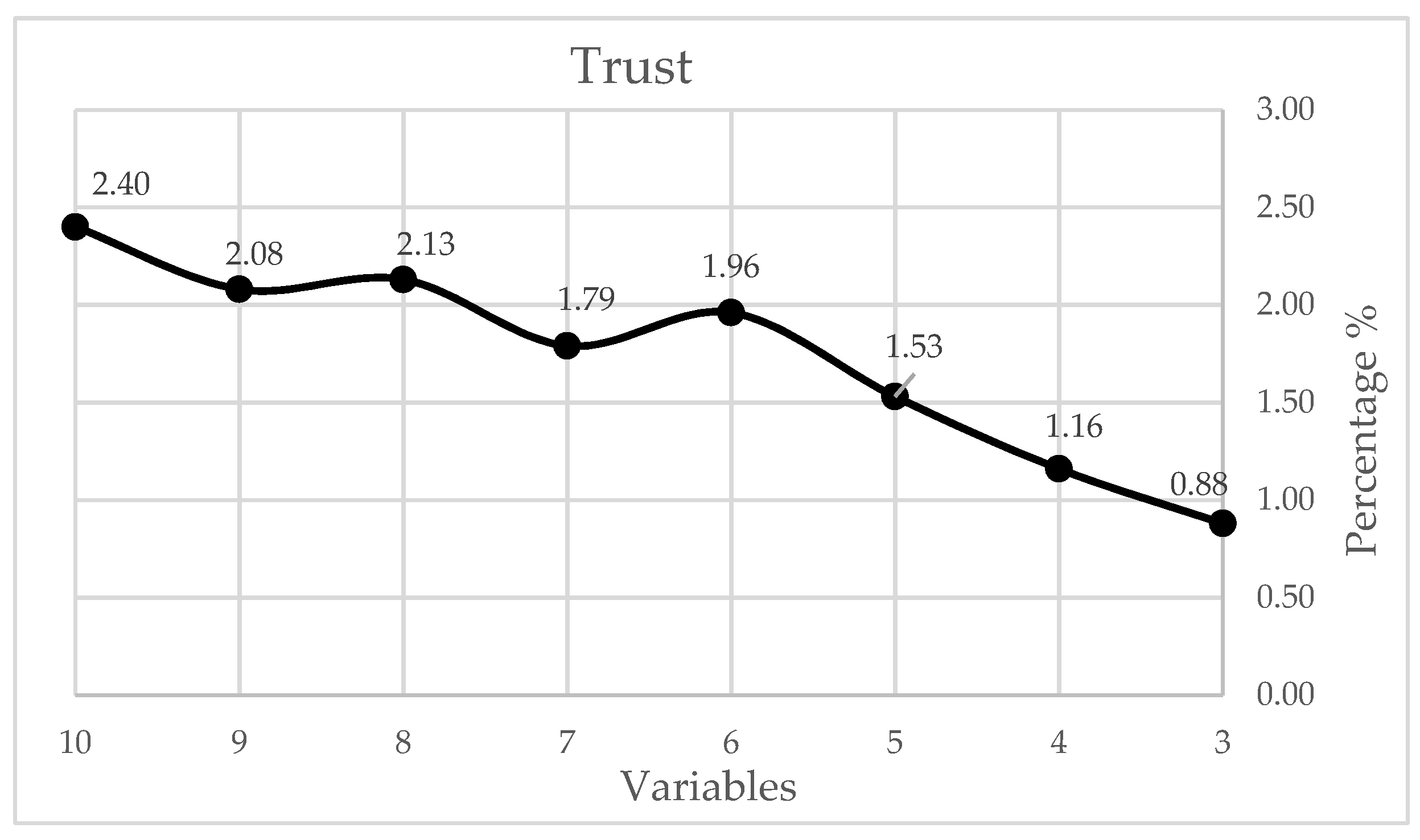
The water table, with a weight of 29.51%, the distance to water sources, with 21.26%, and the type of soil, with 10.36%, constituted 61.13% of the total; that is, these variables highly influence the suitability of the area to implant a cemetery and, therefore, the probability of the transport of contaminants due to the decomposition of corpses, in the environmental matrices that surround a cemetery. The consistency calculation of the Saaty matrix gave a value of 2.40% [71], which indicates that the ranking of the variables is adequate and consistent. If the empirical equations obtained are validated by changing the number of variables and, therefore, their coefficients, through the consistency relationship, percentages less than 10 are obtained (Figure 2), which means the use of the matrix is reliable.
The coefficients obtained in Table 3 are reliable and consistent, since, when submitting the empirical equations developed to validation for different scenarios, they coincided 100% with what was obtained through Arcgis 10.5 software [51]. Therefore, equations 4 to 11 are able to be applied, in order to determine the suitability of the location of cemeteries, whether existing or future, and, at the same time, the probability of environmental contamination.
Considering that not all the documentary data will always be available, the equations obtained allow a range of options to present the information in a preliminary way, ranging from 3 to 10 variables. The suitability assessment equations are applicable at any latitude, since geographic change does not influence the variables analyzed. In other words, they can be applied in any geographical area of the world.
In turn, the proposed equations establish the order of relevance of the variables that need to be considered for the analyses, which determine the water table to be an essential variable, which indicates a decrease in contaminants depending on the depth and can negatively influence areas where the water table is less than 2.5 m [22]. Hereby, the distance to water sources, whose decrease in the concentration of polluting ions occurs after 200 m, is potentially harmful at shorter distances [41], and precipitation due to the increase in metabolic reactions in microorganisms is directly favored, in the presence of a greater contribution of water to its medium [13].
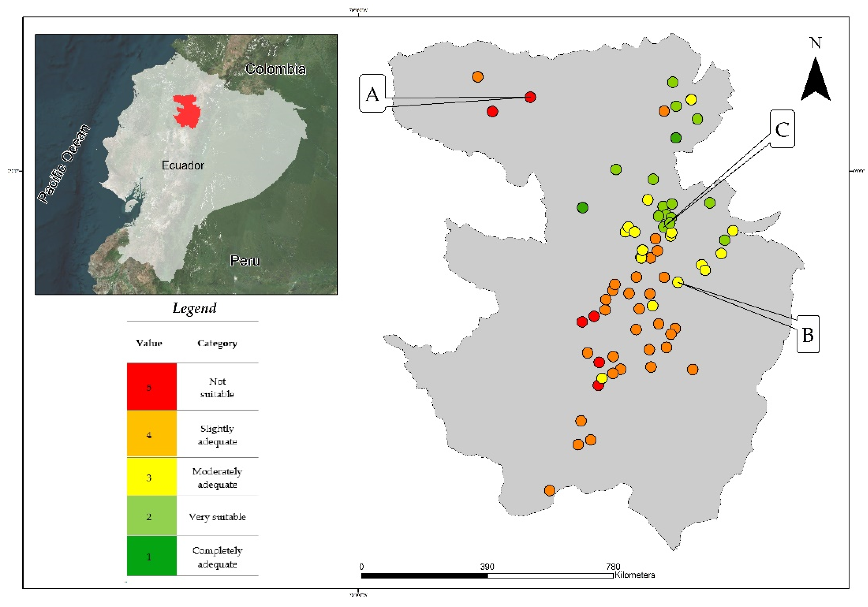
The results obtained in the theoretical validation process for 10, 8, and 6 variables coincides with the Nanegal cemetery being in a “Not Adequate” zone, the Tumbaco cemetery being in a “Moderately Adequate” zone, and the Calderón Cemetery being in a “Very Suitable” zone, as indicated in Table 4, Table 5 and Table 6.
The criteria established, both in the formulation of the empirical indices and in the ranges determined in Table 2 [52], indicate that a cemetery can be considered critical or in an unsuitable area, if, once the values of the sum of variables have been obtained, the result is in a range of 4.01 to 5.00; otherwise, it can be considered slightly adequate in a range of 3.01 to 4.00, moderately adequate in a range of 2.01 to 3.00, very adequate in a range from 1.01 to 2.00, and completely adequate in a range from 0.01 to 1.00. Values greater than 4.01 have a greater probability of presenting risks of environmental contamination. Gomez et al. (2022) performed an analysis of four critical cemeteries, among which is the Nanegal cemetery, determining contamination problems [4]. It is recommended that cemeteries be in ranges from 0.01 to 2.00, since higher values are likely to present problems of environmental contamination.
The assigned values can be modified, according to the criteria of the applicants, if it is easier for them to expand or reduce the range for understanding and estimation. However, the zoning criteria must be preserved. If the values are varied, the summations will, also, vary, so the coverage range of each zone must be established before applying the equations. The ranges proposed above may be used to determine the possible level of contamination of a cemetery, since through them it is recommended that cemeteries be located in dry areas with low levels for precipitation and the water table, considering that several metabolic reactions for microbiological organisms are directly influenced by the presence of a greater contribution of water and temperature in their environment [13,14]. Likewise, locating these sites in hot and humid areas should be avoided, since high temperatures and humidity can accelerate the putrefaction process [13], as well as in sandy soils, since they would allow for the dragging of contaminants [22]. A suitable area for the location of a cemetery is one with clayey or loamy clay soil, since it guarantees a natural waterproofing of the cemetery, thus preventing the infiltration of leachates resulting from the decomposition of the corpses, as well as the migration of physical, chemical, biological, and microbiological levels [53].
Another conditioning factor is the water table on which the cemetery is located, which is recommended to be at distances greater than 4.5 m deep; the distance to water sources be greater than 500 m, since water is the main medium. Transport of contaminants and contaminants resulting from cadaveric decomposition decrease with increasing distance from the source [22,41]. Similarly, geological faults can affect the structures of the pits and facilitate possible infiltrations to the water tables, so cemeteries should not be crossed by them [52].
The slope needs to be considered with another fundamental role. Cemeteries should avoid being located on steep slope sites, since high levels of runoff on sloping land would influence nutrient loss, by affecting the soil erosion area and moving the released leachate to the nearest sub-basin sections [48]. For the establishment of new cemeteries, the most appropriate issue is to, beforehand, perform a study of the conditions to which it will be exposed, analyzing as many variables as possible, or at least the three variables that this study indicates as essential, being the water table, proximity to a body of water, and type of soil [52].
It is necessary, in turn, to regulate the use of metal coffins and change them to more ecological alternatives, such as easily degraded cardboard boxes, in order to reduce the impact on the environment. In addition to seeing the possibility of treating the leachate from these sites, it is important to consider them as a type of sanitary landfill, for example, to be able to waterproof and collect this liquid through drains and collector pipes, so that they can be treated by a wastewater treatment plant (WWTP) [52].

5. Conclusions

The current study obtained some empirical linear equations, which identify whether or not a cemetery is located in an adequate area, and, in turn, determine the probability of environmental contamination to the surrounding environment; this allows for the knowledge of the level of risk that a cemetery would present for the population of the surroundings. Therefore, the variables handled in this work are independent of latitude, so the indices can be applied in any geographical area of the world.
These indices are new and easy-to-apply tools. They will contribute to the authorities when making decisions, since they will facilitate the location and evaluation of existing cemeteries. However, the methodology is valid for future cemeteries, when changes in variables are generated, with an evident savings of economic, technological, time, and personnel resources. Through this analysis of easy bibliographic access, one is able to prioritize resources for cemeteries that are actually more likely to present environmental contamination problems.
Worldwide, the corresponding authorities will be able to use the indices determined in this investigation in the public policies, norms, and procedures for the final disposal of human corpses, including them in their territorial ordering plans.

Author Contributions

Conceptualization, T.C.-P., E.M.-L. and I.S.-G.; methodology, T.C.-P., E.M.-L. and I.S.-G.; software, J.G.-V. and G.F.G.; validation, T.T. and T.C.-P.; formal analysis, T.C.-P. and D.V.-F.; investigation, T.C.-P., J.G.-V., E.M.-L., D.V.-F., G.F.G. and G.F.-N.; resources, T.C.-P., J.G.-V., E.M.-L., D.V.-F., G.F.G., T.T. and G.F.-N.; data curation, J.G.-V.; writing—original draft preparation J.G.-V. and T.C.-P.; writing—review and editing, T.T. and T.C.-P. visualization, G.F.G.; supervision, T.T.; project administration, T.C.-P.; funding acquisition, T.C.-P., J.G.-V., E.M.-L., I.S.-G., D.V.-F., T.T., G.F.G. and G.F.-N. All authors have read and agreed to the published version of the manuscript.

Funding

This research received no external funding.

Institutional Review Board Statement

The study did not require ethical approval.

Informed Consent Statement

Not applicable.

Data Availability Statement

Not applicable.

Conflicts of Interest

The authors declare no conflict of interest.

References

  1. Uçisik, A.S.; Rushbrook, P. The Impact of Cemeteries on the Enviroment and Public Health. Waste Manag. Soil Pollut. WHO Reg. Off. Eur. 1998, 1, 15. Available online: http://whqlibdoc.who.int/euro/1998-99/eur_icp_ehna_01_04_01(a).pdf (accessed on 18 May 2021).
  2. Keijzer, E.E.; Kok, H.J.G. Environmental Impact of Different Funeral Technologies. 2011. Available online: www.tno.nl (accessed on 17 March 2022).
  3. Keijzer, E. The environmental impact of activities after life: Life cycle assessment of funerals. Int. J. Life Cycle Assess. 2017, 22, 715–730. [Google Scholar] [CrossRef]
  4. Flores Gómez, G.; Crisanto-Perrazo, T.; Toulkeridis, T.; Fierro-Naranjo, G.; Guevara-García, P.; Mayorga-Llerena, E.; Vizuete-Freire, D.; Salazar, E.; Sinde-Gonzalez, I. Proposal of an Initial Environmental Management and Land Use for Critical Cemeteries in Central Ecuador. Sustainability 2022, 14, 1577. [Google Scholar] [CrossRef]
  5. Wordldometers. Población Mundial: 7.8 Billones de Personas (2021)—Worldometer. Available online: https://www.worldometers.info/es/poblacion-mundial/ (accessed on 17 March 2022).
  6. Harker, A. Landscapes of the dead: An argument for conservation burial. Berkeley Plan. J. 2012, 25, 150–159. [Google Scholar] [CrossRef] [Green Version]
  7. Ferraz Ferreira, A.R. Body Disposal in Portugal: Current Practices and Potential Adoption of Alkaline Hydrolysis and Natural Burial as Sustainable Alternatives; Facultad de Ciencias Universidad do Portorio: Porto, Portugal, 2016. [Google Scholar]
  8. Toulkeridis, T.; Ortiz-Prad, E.; Chunga-Mora, J.; Heredia-, M.; Debut, A. Excess Mortality Data Analysis of COVID-19 Infections and Fatalities in Ecuador. Uniciencia 2022, 36, 1–12. [Google Scholar] [CrossRef]
  9. Rodrigues, L.; Pacheco, A. Groundwater contamination from cemeteries cases of study. In Proceedings of the Environmental 2010: Situation and Perspectives for the European Union, Porto, Portugal, 6–10 May 2003; pp. 1–6. Available online: http://www.waylandwells.info/wp-content/uploads/2012/07/Groundwater-Contamination-from-Cemeteries-Case-Studies-2010.pdf (accessed on 5 April 2021).
  10. Zychowski, J.; Bryndal, T. Impact of cemeteries on groundwater contamination by bacteria and viruses—A review. J. Water Health 2015, 13, 285–301. [Google Scholar] [CrossRef]
  11. Pallocci, M.; Petroni, G.; Treglia, M.; Giammatteo, J.; Marella, G.L.; Arcangeli, M. Law proposal “provisions on the post-mortem body donation and the use of bodies for the purposes of study, scientific research and training”: Comment and analysis of the bill and the historical-juridical-ethical aspects of cadaveric dissection and practic. Acta Med. Mediterr. 2020, 36, 999–1005. [Google Scholar] [CrossRef]
  12. Ross, A.H.; Cunningham, S.L. Time-since-death and bone weathering in a tropical environment. Forensic Sci. Int. 2011, 204, 126–133. [Google Scholar] [CrossRef]
  13. Clark, M.A.; Worrell, M.B.; Pless, J.E. Forensic Taphonomy: The Postmortem Fate of Human Remains. Forensic Sci. Int. 2001, 116, 227–228. [Google Scholar] [CrossRef]
  14. Ferreira, M.T.; Cunha, E. Can we infer post mortem interval on the basis of decomposition rate? A case from a Portuguese cemetery. Forensic Sci. Int. 2013, 226, 298.e1–298.e6. [Google Scholar] [CrossRef]
  15. Neckel, A.; Korcelski, C.; Silva, L.F.O.; Kujawa, H.A.; Bodah, B.W.; Figueiredo, A.M.R.; Maculan, L.S.; Gonçalves, A.C.; Bodah, E.T.; Moro, L.D. Metals in the soil of urban cemeteries in Carazinho (South Brazil) in view of the increase in deaths from COVID-19: Projects for cemeteries to mitigate environmental impacts. Environ. Dev. Sustain. 2021, 1–24. [Google Scholar] [CrossRef] [PubMed]
  16. Hofle, M.G. Degradation of Putrescine and Cadaverine in Seawater Cultures by Marine Bacteria. Appl. Environ. Microbiol. 1984, 47, 843–849. [Google Scholar] [CrossRef] [PubMed] [Green Version]
  17. Canning, L.; Szmigin, I. Death and disposal: The universal, environmental dilemma. J. Mark. Manag. 2010, 26, 1129–1142. [Google Scholar] [CrossRef]
  18. Neckel, A.; Costa, C.; Mario, D.N.; Sabadin, C.E.S.; Bodah, E.T. Environmental damage and public health threat caused by cemeteries: A proposal of ideal cemeteries for the growing urban sprawl. Urbe 2017, 9, 216–230. [Google Scholar] [CrossRef]
  19. Scalenghe, R.; Pantani, O.L. Connecting existing cemeteries saving good soils (for livings). Sustainability 2020, 12, 93. [Google Scholar] [CrossRef] [Green Version]
  20. Rumble, H.; Troyer, J.; Walter, T.; Woodthorpe, K. Disposal or dispersal? Environmentalism and final treatment of the British dead. Mortality 2014, 19, 243–260. [Google Scholar] [CrossRef] [Green Version]
  21. Williams, A.; Temple, T.; Pollard, S.J.; Jones, R.J.A.; Ritz, K. Environmental considerations for common burial site selection after pandemic events. In Criminal and Environmental Soil Forensics; Springer: Dordrecht, The Netherlands, 2009; pp. 87–101. [Google Scholar]
  22. Spongberg, A.L.; Becks, P.M. Inorganic soil contamination from cemetery leachate. Water. Air. Soil Pollut. 2000, 117, 313–327. [Google Scholar] [CrossRef]
  23. Aruomero, A.S.; Afolabi, O. Comparative assessment of trace metals in soils associated with casket burials: Towards implementing green burials. Eurasian J. Soil Sci. 2014, 3, 65. [Google Scholar] [CrossRef] [Green Version]
  24. Neckel, A.; Korcelski, C.; Kujawa, H.A.; Schaefer da Silva, I.; Prezoto, F.; Walker Amorin, A.L.; Maculan, L.S.; Gonçalves, A.C.; Bodah, E.T.; Bodah, B.W.; et al. Hazardous elements in the soil of urban cemeteries; constructive solutions aimed at sustainability. Chemosphere 2021, 262, 128248. [Google Scholar] [CrossRef]
  25. Lins, E.; Lins, M.; Baltar, S.; Lins, M.; Maria, C.; Silva, M. Negative environmental impacts generated by cemetery: Case study. Int. J. Adv. Sci. Res. 2019, 4, 16–19. Available online: https://www.google.com/url?sa=t&rct=j&q=&esrc=s&source=web&cd=&cad=rja&uact=8&ved=2ahUKEwiOlvyMn872AhWMTTABHcTUB5oQFnoECAQQAQ&url=http%3A%2F%2Fwww.allsciencejournal.com%2Fdownload%2F476%2F4-6-33-218.pdf&usg=AOvVaw1NDpin6-8z6Mkecxij42k1 (accessed on 17 March 2022).
  26. Méndez, Y.; Calderón, F. Evaluación de las aguas subterráneas contaminadas con putrescina y cadaverina en las zonas aledañas a los cementerios del norte de Bogotá y el campus de la Universidad Santo Tomás. Hallazgos 2010, 7, 151–163. [Google Scholar] [CrossRef]
  27. Organización Panamericana de la Salud. La Gestión de cadáveres en Situaciones De Desastres, 6th ed.; Morgan, O., Tidball-Binz, M., van Alphen, D., Eds.; Organización Panamericana de la Salud: Washington, DC, USA, 2017; ISBN 92 75 32630 4 I. [Google Scholar]
  28. Jaimes Morales, J.; Pérez Díaz, K.; Severiche Sierra, C.A. Riesgo toxicológicos por la exposición ocupacional al formaldehido en sala de anatomía patológica. Ciencia y Salud Virtual 2014, 6, 141. [Google Scholar] [CrossRef] [Green Version]
  29. Saltzman, B.E.; Gross, S.B.; Yeager, D.W.; Meiners, B.G.; Gartside, P.S. Total body burdens and tissue concentrations of lead, cadmium, copper, zinc, and ash in 55 human cadavers. Environ. Res. 1990, 52, 126–145. [Google Scholar] [CrossRef]
  30. Dent, B.; Knight, M. Cemeteries: A Special Kind of Landfill. The Context of Their Sustainablemanagement. In Proceedings of the Conference of the International Association of Hydrogeologists: Groundwater: Sustainable Solutions, Melbourne, Australia, 22 April 1998. [Google Scholar]
  31. Carter, D.O.; Yellowlees, D.; Tibbett, M. Moisture can be the dominant environmental parameter governing cadaver decomposition in soil. Forensic Sci. Int. 2010, 200, 60–66. [Google Scholar] [CrossRef]
  32. Velasco Rivera, A.; Minota Zea, Y.M. Evaluación por contaminación en suelos aledaños a los cementerios Jardines del Recuerdo e Inmaculada. Cienc. e Ing. Neogranadina 2012, 22, 165. [Google Scholar] [CrossRef]
  33. Pedrosa, A.; Figueiredo, F.P.O.; Azevedo, J.M.M.; Tavares, A.O. Geologia ambiental associada a cemitérios: Estudo de caso na região centro de Portugal. Comun. Geol. 2014, 101, 1037–1041. Available online: http://www.lneg.pt/iedt/unidades/16/paginas/26/30/185 (accessed on 17 March 2022).
  34. Vélez, S.; Monsalve, T.; Quiroz, M.L.; Castañeda, D.; Cardona-Gallo, S.A.; Terrazas, A.; Sedov, S. The study of necrosols and cemetery soils. Dyna 2019, 86, 337–345. [Google Scholar] [CrossRef] [Green Version]
  35. Francis, D.; Kellaher, L.; Neophytou, G. Sustaining cemeteries: The user perspective. Mortality 2000, 5, 34–52. [Google Scholar] [CrossRef]
  36. Rawson, A.C. R.I.P. to RLUIPA: The Ongoing Debate of RLUIPA as Applied to Local Cemetery Ordinances is Finally Laid to Rest. Roger Williams Univ. Law Rev. 2018, 23, 10. [Google Scholar]
  37. Morgan, O. Infectious disease risks from dead bodies following natural disasters. Rev. Panam. Salud Publica Pan Am. J. Public Health 2004, 15, 307–312. [Google Scholar] [CrossRef]
  38. da Cruz, N.J.T.; Lezana, Á.G.R.; dos Santos, P.C.F.; Santana Pinto, I.M.B.; Zancan, C.; Silva de Souza, G.H. Environmental impacts caused by cemeteries and crematoria, new funeral technologies, and preferences of the Northeastern and Southern Brazilian population as for the funeral process. Environ. Sci. Pollut. Res. 2017, 24, 24121–24134. [Google Scholar] [CrossRef] [PubMed]
  39. Scrimshaw, M.D.; Wong, J.W.C. A survey of green burial sites in England and Wales and an assessment of the feasibility of a groundwater vulnerability tool. Environ. Technol. 2008, 29, 1. [Google Scholar] [CrossRef] [PubMed]
  40. Zychowski, J. Impact of cemeteries on groundwater chemistry: A review. Catena 2012, 93, 29–37. [Google Scholar] [CrossRef]
  41. Pinder, G.F. Groundwater hydrology. In Groundwater Quantity and Quality Management; Wiley: Hoboken, NJ, USA, 2011; pp. 10–35. [Google Scholar]
  42. Fineza, A.G.; Marques, E.A.G.; Bastos, R.K.X.; Betim, L.S. Impacts on the groundwater quality within a cemetery area in southeast Brazil. Soils Rocks 2014, 37, 161–169. Available online: https://www.soilsandrocks.com/sr-3725 (accessed on 17 March 2022).
  43. Rhoades, J.D.; Kandiah, A.; Mashali, A.M. Saline waters as resources. In The Use of Saline Waters for Crop Production: Guidelines on Water, Soil and Crop Management; Food and Agriculture Organization of the United Nations: Rome, Italy, 1992; ISBN 92-5-103237-8. [Google Scholar]
  44. Metcalf, L.; Eddy, H.P.; Tchobanoglous, G. Wastewater Energy: Treatment and Reuse; McGraw-Hill: New York, NY, USA, 2004; ISBN 007124140X. [Google Scholar]
  45. Eche, J.J.E. Evaluación de Impacto Ambiental de un Cementerio Tipo Parque Ecológico. Rev. Inst. Investig. Fac. Ing. Geológica Minera Metal. Geográfica 2001, 4, 53–58. [Google Scholar] [CrossRef]
  46. Neckel, A.; Celso Gonçalves Junior, A.; Ribeiro, L.A.; Oliveira, C.; Silva, A.; Cardoso, G.T. Cemeteries heavy metals concentration analysisof soils and the contamination risk for the surrounding resident population. J. Eng. Res. Appl. 2016, 6, 30–35. Available online: www.ijera.com (accessed on 27 April 2022).
  47. Li, Y.; Wang, C.; Tang, H. Research advances in nutrient runoff on sloping land in watersheds. Aquat. Ecosyst. Health Manag. 2006, 9, 27–32. [Google Scholar] [CrossRef]
  48. Bouwer, H. Ground-water hydrology. Nature 1924, 113, 175. [Google Scholar] [CrossRef]
  49. Jonker, C.; Olivier, J. Mineral Contamination from Cemetery Soils: Case Study of Zandfontein Cemetery, South Africa. Int. J. Environ. Res. Public Health 2012, 9, 511–520. [Google Scholar] [CrossRef]
  50. Arcos Yánez, E.S. Identificación de Zonas Ambientalmente no Adecuadas Para la Ubicación de Camposantos en los Cantones Mejía, Quito y Rumiñahui; Universidad de las Fuerzas Armdas “ESPE”: Sangolqui, Ecuador, 2020. [Google Scholar]
  51. Guayasamín Vergara, J.D. Establecimiento de Índices Empíricos Ambientales Para Manejo de Cadáveres Humanos: Entierro y Cremación en Ecuador; Universidad de las Fuerzas Armadas ESPE: Sangolqui, Ecuador, 2021. [Google Scholar]
  52. Nawrocki, S.P. Forensic taphonomy. In Handbook of Forensic Anthropology and Archaeology; Taylor and Francis: Abingdon, UK, 2016; pp. 373–390. ISBN 9781315528922. [Google Scholar]
  53. Harrington, D.E.; Krynski, K.J. The effect of state funeral regulations on cremation rates: Testing for demand inducement in funeral markets. J. Law Econ. 2002, 45, 199–225. [Google Scholar] [CrossRef] [Green Version]
  54. Okafor, I.A.; Chia, T. Covid-19: Emerging Considerations for Body Sourcing and Handling. A Perspective View from Nigeria. Anat. Sci. Educ. 2021, 14, 154–162. [Google Scholar] [CrossRef] [PubMed]
  55. Wolch, J.R.; Byrne, J.; Newell, J.P. Urban green space, public health, and environmental justice: The challenge of making cities ‘just green enough’. Landsc. Urban Plan. 2014, 125, 234–244. [Google Scholar] [CrossRef] [Green Version]
  56. Haaland, C.; van den Bosch, C.K. Challenges and strategies for urban green-space planning in cities undergoing densification: A review. Urban For. Urban Green. 2015, 14, 760–771. [Google Scholar] [CrossRef]
  57. Nguyen, X.L.; Chou, T.Y.; Van Hoang, T.; Fang, Y.M.; Nguyen, Q.H. Research on Optimal Cemetery Location Selection using Approach of Fuzzy Set Theory and Analytic Hierarchy Process in Environment of Geographic Information System: A Case Study in Hung Ha District, Thai Binh province, Vietnam. Int. J. Res. Innov. Earth Sci. 2019, 6. Available online: http://www.ijries.org/administrator/components/com_jresearch/files/publications/IJRIES_187_FINAL.pdf (accessed on 22 May 2021).
  58. Mahlangu, S.; Lorentz, S.; Diamond, R.; Dippenaar, M. Surface water-groundwater interaction using tritium and stable water isotopes: A case study of Middelburg, South Africa. J. African Earth Sci. 2020, 171, 103886. [Google Scholar] [CrossRef]
  59. Dian, Z. Land for the Dead Locating Urban Cemeteries, Case Study Guilin, China; International Institute for Geo-Information Science and Earth Observation: Enschede, The Netherlands, 2004. [Google Scholar]
  60. Lotfi, S.; Habibi, K.; Javad Koohsari, M. Integrating multi-criteria models and Geographical information system for cemetery site selection (A case study of the Sanandaj city, Iran). Acta Geogr. Slov. 2009, 49, 179–198. [Google Scholar] [CrossRef] [Green Version]
  61. Stroganova, M.; Prokofieva, T. Urban soils classification for Russian cities of the taiga zone. Soil Classif. 2002, 153–156. [Google Scholar]
  62. Sukhacheva, E.Y.; Revina, Y.S. Medium-Scale Soil Map of the Crimea Southern Coast. Eurasian Soil Sci. 2020, 53, 397–404. [Google Scholar] [CrossRef]
  63. Judge, R. Towards a Methodology for Identifying Potential Sites for Cemeteries. Ph.D. Thesis, Nelson Mandela Metropolitan University, Gqeberha, South Africa, 2012. [Google Scholar]
  64. Długozima, A. How to find a suitable location for a cemetery? Application of multi-criteria evaluation for identifying potential sites for cemeteries in Białystok, Poland. Morav. Geogr. Rep. 2022, 30, 34–53. [Google Scholar] [CrossRef]
  65. Municipio del Distrito Metropolitano de Quito Plan de Uso y Gestión del Suelo 2020–2030; Corporación Instituto de la Ciudad: Quito, Ecuador, 2020.
  66. Gobierno Autónomo Descentralizado Municipal del Cantón Mejía. Actualización del Plan de Ordenamiento Territorial del Cantón Mejía 2015–2025. 2014. p. 510. Available online: http://www.municipiodemejia.gob.ec/documents/ordenanzas/act-pdot-2015.pdf (accessed on 22 May 2021).
  67. Plan de Desarrollo y and T. [PDOT]. Atlas Cantón Rumiñahui. Sangolquí-Ecuador, Dirección de Planificación. GADMUR. 2012. Available online: http://181.112.151.212/Documentacion/LOTAIP/2015/pdf/s/DOCUMENTO_PDYOT_FINAL.pdf (accessed on 4 April 2021).
  68. Saaty, T.L. What is the analytic hierarchy process? In Mathematical Models for Decision Support; Springer: Berlin/Heidelberg, Germany, 1988; pp. 109–121. [Google Scholar]
  69. Saaty, T.; Kułakowski, K. Axioms of the Analytic Hierarchy Process (AHP) and its Generalization to Dependence and Feedback: The Analytic Network Process (ANP). arXiv 2016, arXiv:1605.05777. [Google Scholar]
  70. Saaty, T.L. Fundamentals of the Analytic Hierarchy Process; Springer: Dordrecht, The Netherland, 2001; pp. 15–35. [Google Scholar]
  71. Toulkeridis, T.; Tamayo, E.; Simón-Baile, D.; Merizalde-Mora, M.J.; Reyes-Yunga, D.F.; Viera-Torres, M.; Heredia, M. Climate change according to ecuadorian academics-perceptions versus facts. Granja 2020, 31, 21–49. [Google Scholar] [CrossRef] [Green Version]
Figure 1. Categorization of cemeteries in central Ecuador. A = Nanegal; B = Tumbaco; C = Calderón.
Sustainability 14 06284 g001
Figure 2. Consistency of empirical indices for all cases.
Sustainability 14 06284 g002
Table 1. Variables considered for the determination of empirical indices.
DescriptionVariables
109876543
Phreatic level (A)AAAAAAAA
Distance to water sources (B)BBBBBBBB
Precipitation (C)CCCCCCCC
Sloping land (D)DDDDDDD-
Soil type (E)EEEEEE--
Graveyard age (F)FFFFF---
Temperature (G)GGGG----
Number of graves (H)HHH-----
Geologic fault (I)II------
Population density (J)J-------
Table 2. Variables considered for the determination of empirical indices.
ABCDEFG HIJ
(m)(m)(mm)(%)(Type)(Year)(°C)(und)(Km)(hab/km2)
0.5–1.50–200>3000Very Strong > 40Gross sand, Sandy, Loamy Sandy<1833>20>50,0010–5Very High > 160
1.5–2.5200–5002000–3000Strong 25–40Sandy loam, Loam, Slimy loam1833–193316-2025,000–50,0005–10High (81–160)
2.5–3.5500–15001000–2000Half 5–25Clay loam—Slimy1933–198311–155001–25,00010–15Half (21–80)
3.5–4.51500–4000500–1000Mild 2–5Clay loam, Slimy, Sandy—Clay 1983–200806–101001–500015–20Drop (3–20)
>4.5>40000–500Level 0–2Silty—Clay, Clayey2008–20201–50–1000>20Empty areas (0–2)
A = Phreatic level; B = Distance to water sources; C= Precipitation; D = Sloping land; E = Soil type; F = Graveyard age; G = Temperature; H = Number of graves; I = Geologic fault; J = Population density.
Table 3. Environmental empirical indices for the study variables.
DescriptionVariables
109876543
A0.29150.31190.33110.35430.38250.41850.46730.5396
B0.21260.22060.23940.23920.25040.26250.27720.2970
C0.14980.15240.15510.15730.15960.15990.16010.1634
D0.10360.10330.10300.10170.10060.09730.0954-
E0.69870.06830.06720.06500.06410.0618--
F0.04520.04360.04270.04130.0428---
G0.04520.04360.04270.0413----
H0.02920.02820.0288-----
I0.02920.0282------
J0.0203-------
A = Phreatic level; B = Distance to water sources; C= Precipitation; D = Sloping land; E = Soil type; F = Graveyard age; G = Temperature; H = Number of graves; I = Geologic fault; J = Population density.
Table 4. Validation of indices in three study cemeteries with 10 variables.
ItemDescriptionIndicesNanegalTumbacoCalderon
CategoryValueCategoryValueCategoryValue
1A0.291541.1820.5910.30
2B0.212651.0630.6430.64
3C0.149840.6020.3010.15
4D0.103650.5230.3120.21
5E0.698720.1420.1420.14
6F0.045230.1430.1430.14
7G0.045250.2340.1830.14
8H0.029210.0330.0910.03
9I0.029220.0650.1530.09
10J0.020350.1050.150.10
Total4.05Total2.63Total1.92
Table 5. Validation of indices in three study cemeteries with eight variables.
ItemDescriptionIndicesNanegalTumbacoCalderon
CategoryValueCategoryValueCategoryValue
1A0.331141.3220.6610.33
2B0.239451.1530.6930.69
3C0.155140.6220.3110.16
4D0.103050.5230.3120.21
5E0.067220.1320.1320.13
6F0.042730.1330.1330.13
7G0.042750.2140.1730.13
8H0.028810.0330.0910.03
Total4.11Total2.49Total1.80
Table 6. Validation of indices in three study cemeteries with six variables.
ItemDescriptionIndicesNanegalTumbacoCalderon
CategoryValueCategoryValueCategoryValue
1A0.382541.5320.7710.38
2B0.250451.2530.7530.75
3C0.159640.6420.3210.16
4D0.100650.5030.3020.20
5E0.064120.1320.1320.13
6F0.042830.1330.1330.13
Total4.18Total2.39Total1.75
Publisher’s Note: MDPI stays neutral with regard to jurisdictional claims in published maps and institutional affiliations.

