
Applicability Evaluation of Landslide Vulnerability Criteria for Decision on Landcreep-Vulnerable Areas in South Korea


1
Division of Environmental and Forest Science, Gyeongsang National University, Jinju 52725, Korea
2
Korea Association of Forest Enviro-Conservation Technology, Cheongju 28165, Korea
*
Author to whom correspondence should be addressed.
Sustainability 2022, 14(8), 4447; https://0-doi-org.brum.beds.ac.uk/10.3390/su14084447
Submission received: 2 March 2022
/
Revised: 30 March 2022
/
Accepted: 7 April 2022
/
Published: 8 April 2022
(This article belongs to the Special Issue Sustainable Forest Management and Natural Hazards Prevention)
Abstract
:Landcreep, which is a natural hazard, frequently occurs in South Korea. However, despite many differences between general landslides and landcreep, landcreep is still treated as a kind of landslide. A bigger problem in this reality is that no verification has been made on whether the national landslide vulnerability criteria can be applied to the decision on landcreep-vulnerable areas. Therefore, this study was conducted to examine the applicability of the landslide vulnerability criteria for the decision on landcreep-vulnerable areas. For verification, first, as a result of a correlation analysis that extracted seven types of geomorphological environment criteria that are used in deciding landslide-vulnerable areas from 57 landcreep areas, a positive correlation was shown only in the slope type and the parent rock. Second, as a result of the evaluation of the landcreep area by applying the landslide vulnerability criteria, it was analyzed that 61.4% were areas with low or no possibility of the occurrence of landslides. Third, on the basis of the overlapping analysis of the landslide hazard map and landcreep areas, 67.6% were in Level 3 or lower, except for Levels 1 and 2, which had high hazards, and 21.5% were landcreep areas that were not included in the hazard levels. Applying the landslide vulnerability criteria for deciding on landcreep-vulnerable areas is not appropriate, and it is urgent to prepare landcreep vulnerability criteria.
1. Introduction
Natural hazards are a frequent phenomenon worldwide [1]. In particular, landslides are the most destructive natural hazards in many parts of the world. Moreover, these landslides can cost billions of dollars and can cause serious problems, such as deaths, injuries, and widespread damage to property and infrastructure, which can cause further landslides [2,3]. According to a World Bank report, around 300 million people worldwide live in landslide-vulnerable areas, and about 600 people die each year in landslides [4]. The economic loss from landslides is estimated at USD 20 billion worldwide. Countries such as the United States, Italy, India, China, and Germany experience significant losses each year [5]. Recently, landslide damage has increased in South Korea because of frequent heavy rains. In particular, the area that was damaged by localized heavy rain during Typhoons Maysak and Haishen in 2020 was 1343 ha, and the restoration cost was USD 305 million. There were also nine deaths [6].
On the other hand, the natural hazards in Hyuseok-dong and Choongcheongbuk-do of South Korea in 1995 turned out to be landcreep that was first reported in South Korea, and not general landslides [7]. Since then, interest in landcreep has gradually increased, especially in academia. However, the reality is that the South Korean administrative authorities have been treating landcreep as a kind of general landslide until now.
Landcreep is different from general landslides in its fundamental mechanism and in the attributes of the debris flow that is generated [8]. There are several differences between landcreep and landslides. First, landcreep is generated underground, while landslides occur on the ground surface. Second, the effect of landcreep extends up to approximately 100 m underground, while landslides are very shallow in depth. Third, landcreep progresses much slower than landslides: for landcreep, the form of the activity clod is like a circle, but that of a landslide is closer to tears or falls. Fourth, landcreep tends towards recurrence: landcreep moves slightly, owing to specific geological features or underground structures in gentle slope areas, while landslides frequently occur owing to precipitation. Fifth, underground water greatly affects landcreep, and the affected areas were primarily used as farmland in South Korea. Sixth, landcreep exhibits precursors, including the tilting of trees and cracks on the ground, while landslides normally do not present any precursors [9,10].
Landcreep may be caused by weathered clay particles that are contained in the soil [11,12]; discontinuity, and the fragmental zone of faults in the strata [8,13,14,15]; erosion due to freezing–thawing [16]; a reduced shearing force of the soil due to skyrocketing underground water levels and pore water pressure [17,18,19]; and various development activities [8,10]. Landcreep is known to occur in Japan continuously; however, South Korea has also been consistently witnessing it since 1995, with recurrences in the same areas [8] and discoveries of previously affected areas, which has added to the number of cases of landcreep. In Pohang and Gyeongsangbuk-do, the cases are being affected by soil vibrations that are due to earthquakes [20]. In addition, the mountain hazards that are caused by landcreep have led to much larger areas of damage, which do not measure up to those from regular landslides or from collapse and recurrence [8,10,21].
Therefore, constant vigilance is needed in order to mitigate these mountain hazards. Lee et al., in 2009, 2011, and 2015 [22,23,24], established a national landslide forecast system using the soil function index by assessing the areas of debris flow through the extraction of the optimal parameters of a random work model, and by calculating the criteria of the precipitation for generating evacuation alerts against mountain soil hazards by using a tank model. However, landcreep has a different fundamental mechanism, as well as different geological features and topographies, than other landslides, and it occurs more frequently in areas with low risks and in Level 1 areas [10], which require preventive measures against landcreep hazards through the creation of landcreep vulnerability criteria.
Previous studies have published results on the causes of landcreep [8,9,10,11,12,13,14,15,16,17,18,19,20]. However, in the reality that landcreep is being treated as a kind of landslide, research on whether the national landslide vulnerability criteria can be applied to the decision on the vulnerability of the land has not been studied.
Therefore, this study was carried out to inform the justification and urgency of preparing the landcreep vulnerability criteria, and to provide basic data to prepare the criteria. For this purpose, a correlation analysis between the geomorphological environment criteria of the landcreep areas that occurred in South Korea, an evaluation of the landcreep areas through the application of the landslide vulnerability criteria [25], and an overlapping analysis of a landslide hazard map [6] and the landcreep areas were conducted in this study. In addition, we attempted to prove the clear difference between the occurrences of landcreep and landslides, and to assert the necessity and urgency of an in-depth study to establish landcreep vulnerability criteria.
2. Materials and Methods
2.1. Research Sites and Basic Data Acquisiton
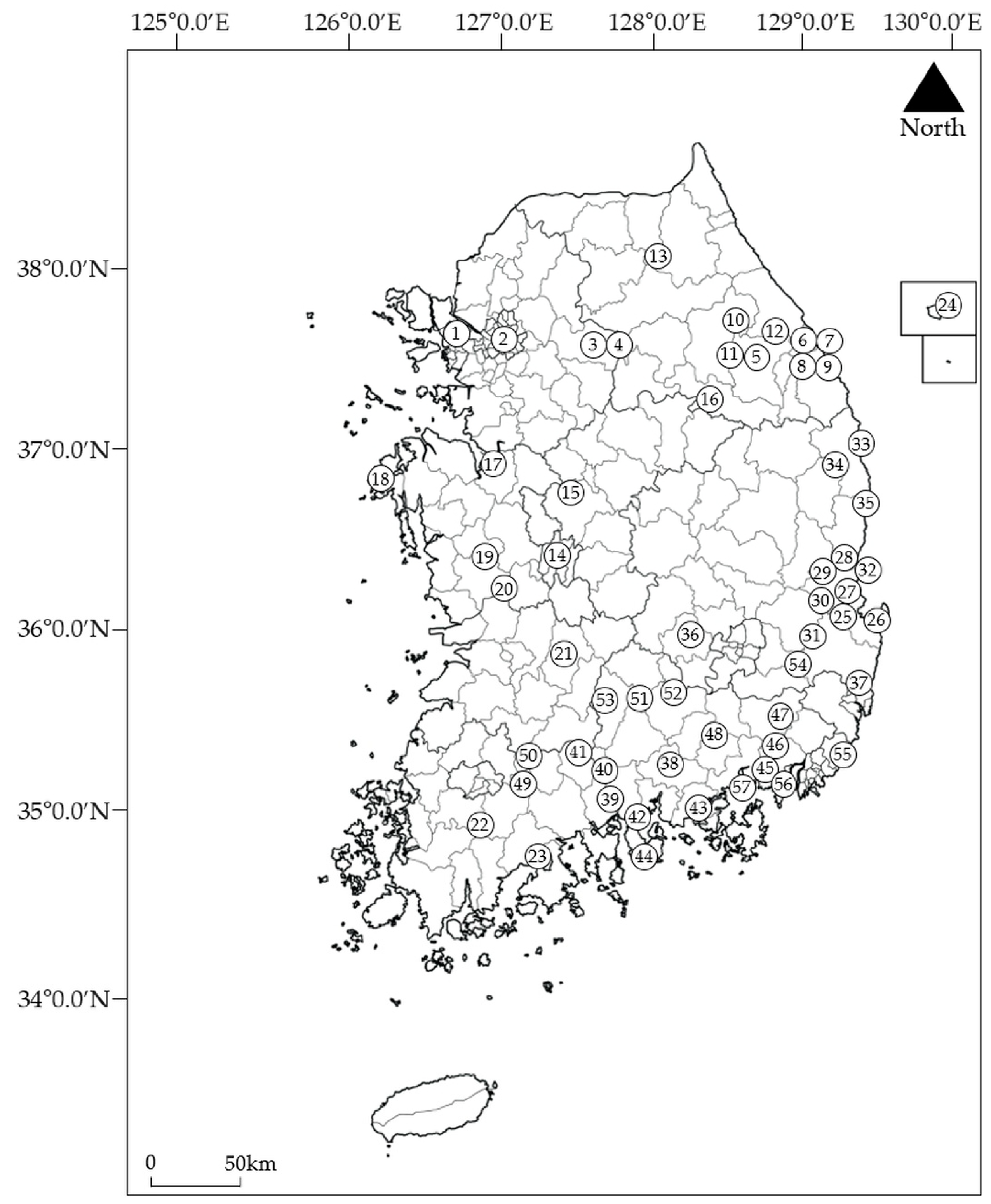
This study was conducted in the landcreep areas in South Korea from 1995 to 2017. The target site of this study was 57 sites (n = 57), which included all areas where restoration was completed or where the landcreep occurred again (Figure 1). For each landcreep area, boundary data with non-occurring areas were acquired by using a portable GPS. Information on each geomorphological environment criterion was acquired for the entire landcreep area by using the data, and not by a sampling method. The geomorphological environment criteria described below were extracted by using boundary data from the topographic map (National Geographic Information Institute (Suwon, Korea), 1:5000), the forest type map (Korea Forest Service (Daejeon, Korea), 1:5000), the forest soil map (Korea Forest Service, 1:25,000), and the geological map (Korea Institute of Geoscience and Mineral Resources (Daejeon, Korea), 1:50,000), and then the average values were calculated. Moreover, the boundary data of the landcreep area were used to evaluate the actual landcreep area to which the landslide vulnerability criteria were applied, and for the overlap analysis of the landslide hazard map and the landcreep area.
2.2. Research Methods
2.2.1. Correlation Analysis between Geomorphological Environment Criteria of the Landcreep Areas
To analyze the criteria that affect the occurrence of landcreep, 7 types of geomorphological environment criteria, which are the landslide vulnerability criteria [25] that are stipulated in the Enforcement Rule of the Mountainous Districts Management Act in South Korea, were extracted from 57 landcreep areas, and a correlation analysis was performed. The landslide vulnerability criteria in South Korea include the slope length (m), the parent rock, the slope position (10 divisions), the forest type, the slope type, the soil depth (cm), and the degree of slope (°), and it is composed of 7 geomorphological environment criteria and the investigator’s correction score (personal judgment on the site). However, in this study, only 7 types of geomorphological environment criteria that can be objectively analyzed were used for analysis. The likelihood of landslides in South Korea increases as the slope length increases, the slope position increases, and the soil depth increases. The lower the degree of the slope below 40 degrees, the higher the likelihood of landslides. Moreover, the probability of landslides increases when the parent rock is metamorphic rock (gneiss type and schist type) and igneous rock (porphyry type and andesite type), when the forest type is coniferous forest, and when the slope type is an equilibrium slope and a convex slope. The analysis was performed using SPSS Ver. 21 by IBM (Armonk, NY, USA).
2.2.2. Evaluating Landcreep Areas by Applying the Landslide Vulnerability Criteria
We analyzed whether the landslide vulnerability criteria [25] can be applied to the decision on landcreep-vulnerable areas. To this end, the vulnerability grade was analyzed by applying 7 geomorphological environment criteria among the landslide vulnerability criteria to the landcreep areas (n = 57). According to the criteria in South Korea, the landslide vulnerability grade is divided into four categories, and the sums of the scores corresponding to the criteria are classified as follows: (1) Areas with a very high probability of the occurrence of landslides (180 points ≤ the score); (2) Areas with a high probability of the occurrence of landslides (120 points ≤ the score < 180 points); (3) Areas with a low probability of the occurrence of landslides (61 points ≤ the score < 120 points); and (4) Areas where landslides are not likely (the score ≤ 60 points).
2.2.3. Overlapping Analysis of Landslide Hazard Map and Landcreep Areas
The landslide hazard map, another piece of information, was provided, in addition to the landslide vulnerability criteria, through the Landslide Information System of the Korea Forest Service (KFS). An overlapping analysis was performed to determine whether the landslide hazard map can be applied to the decision on landcreep-vulnerable areas. The landslide hazard map of South Korea is produced using nine criteria: the degree of the slope, the slope bearing, the slope length, the slope curvature, the topographic wetness index (TWI), the forest type, the diameter of breast height (DBH), the soil depth, and the parent rock. Each criterion is extracted from the topographic map (National Geographic Information Institute, 1:5000), the forest type map (Korea Forest Service, 1:5000), the forest soil map (Korea Forest Service, 1:25,000), and the geological map (Korea Institute of Geoscience and Mineral Resources, 1:50,000). Among these nine criteria, the probability of landslides, which is calculated according to the influence of each criterion through logistic regression analysis, is divided into 5 hazard levels and produced as a map [6]. Meanwhile, ArcGIS 10.3.1 by ESRI (Redlands, CA, USA) was used for the overlapping analysis.
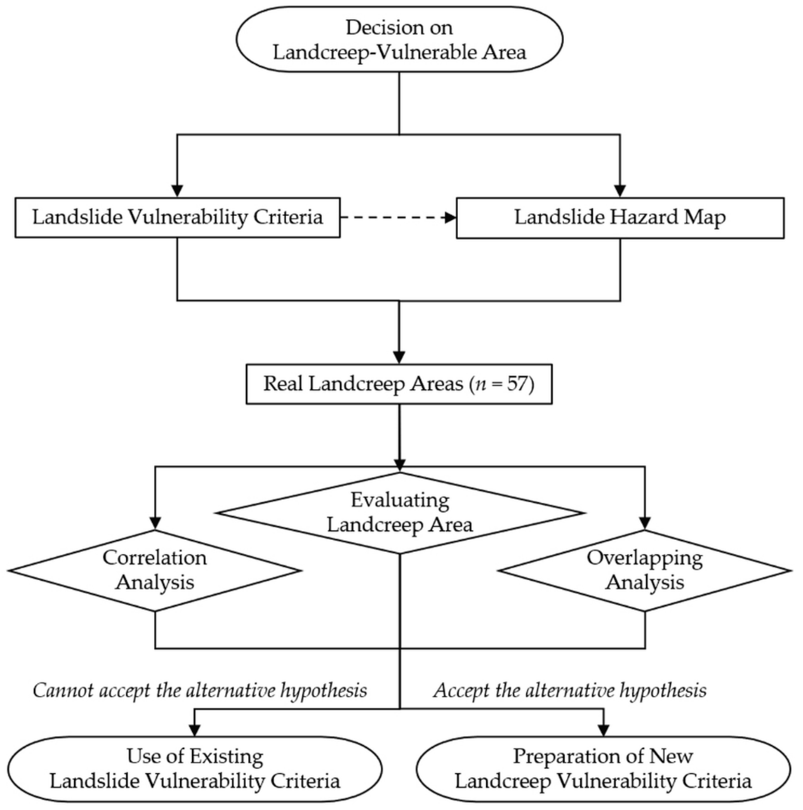
In addition, the overall flow of the study is as shown in the flow diagram (Figure 2). Here, in this study, the null hypothesis was established that the occurrence mechanisms of general landslides and landcreep are the same. On the other hand, the alternative hypothesis is that the occurrence mechanisms of general landslides and landcreep are different.
3. Results and Discussion
3.1. Correlation Analysis Results between the Geomorphological Environment Criteria of the Landcreep Areas
The correlation analysis was conducted by extracting seven types of geomorphological environment criteria, which are the landslide vulnerability criteria, from 57 landcreep areas. As a result, the slope type and the parent rock showed a positive correlation at the 5% significance level (Pearson correlation = 0.494). There was no statistical significance among the criteria, excluding these criteria (Table 1). In correlation analysis, it is generally judged that there is a problem with multicollinearity if the correlation coefficient is more than ±0.9. However, if it is less than ±0.7, it is judged to be safe from the multicollinearity problem. On the basis of these results, the slope type and the parent rock were important factors that were used as landcreep vulnerability criteria. It is judged that the five types of geomorphological environment criteria (the slope length, slope position, forest type, soil depth, and degree of slope) of the landslide vulnerability criteria were not suitable for application to the decision on landcreep-vulnerable areas.
Meanwhile, in previous studies, precipitation [26], rainfall [27], the soil texture [28,29], the groundwater level [30,31], the soil temperature, and artificial forest development [31] were suggested as major factors for landcreep occurrence. However, the seven criteria (national landslide vulnerability criteria) used in the analysis are extremely geomorphological environment factors. Therefore, an analysis that includes the various external environmental factors reported in previous studies will be required.
In the slope types of 57 landcreep areas, the largest number were convex slopes in 31 areas (54.4%), followed by 14 complex slopes (24.6%), and 12 concave slopes (21.1%) (Table A1). Many landcreep areas occur on convex slopes, while many common landslides occur on composite slopes [23]. Different slope types are considered to bring about different consequences (i.e., the occurrence of landslides or landcreep).
As for the parent rocks of the 57 landcreep areas, the igneous rocks were 7 (12.3%), the metamorphic rocks were 14 (24.6%), and the sedimentary rocks were 36 (63.2%) (Table A1). The landcreep in South Korea was the most common in sedimentary rock areas because sedimentary rocks of the Mesozoic and Cenozoic periods usually appear as a mixture of sandstone, clay rock, shale, and limestone, or as an alternation of these. Among these rocks, clay rock or shale becomes clay soil when weathered, which makes the occurrence of landcreep easier [21]. Therefore, this is different from the report that states that general landslides occur mainly in weathered igneous rock [21], whereas landcreep mainly occurs in sedimentary rock areas, including clay rock [12]. Park, in 2016 [10], stated that the criteria that affect landcreep are the geological features, the supergroup, the parent rocks, the number of days of precedent rainfall, and the amount of precedent rainfall. Woo, in 1992 [9], stated that landcreep is included in the broad category of landslides; however, it creeps very slowly, in the range of 0.01–10 mm/day, with a different mechanism from that of a general landslide, which is a phenomenon where the earth becomes saturated by external criteria, such as rainfall, and collapses abruptly. Choi et al., in 2011 [32], stated that slanted trees and trees that are bent by creep are strong evidence that support fluidal landslides, such as past or presently progressing landcreep, and that the damage to trees that is due to a landslide that collapses at once differs from that due to landcreep, where we can identify its progress.
On the other hand, Lee et al., in 2009, 2011, and 2015 [22,23,24], noted that the longer the slope is, the more landslides are likely to happen in weathered igneous rock areas. As for the slope position, landslides tend to be more severe when more rain falls on a valley that is already filled with water from precipitation [9]. In the forest type, artificial coniferous forests with shallow roots were vulnerable to landslides. It is said that the slope type is dangerous near the inflection point, where the slope changes suddenly, or near a straight line, and that landslides occur on steep slopes [22,23,24]. However, among the 57 landcreep areas, the average length was 200.3 m (22.1–920.6 m), which is inconsistent with the slope length that was calculated by using the landslide vulnerability criteria. The longest one was 920.6 m, where the effect reached the top owing to the impact of the soil-and-stone-gathering activities, and it tremendously lengthened the slope length of the damaged area. Except for this case, the lengths were below 110 m in 18 landcreep areas, which accounted for approximately 31.6% of all the affected areas (Table A1). The mountainous areas are divided into 10 in South Korea. General landslides are mainly focused on the top of a mountain ((7–10)/10) or at mountain bellies ((4–6)/10), while landcreep frequently occurs at the bottom of a mountain ((1–3)/10) or at a lower location. To support this, the upper parts of 36 areas (63.2%) of the 57 landcreep areas were below the bottom of a mountain (Table A1).
Kim, in 2006 [33] (2006), reported that the soil layer in landslide areas shows a bad distribution of particles and a loose ground state, compared to non-landslide areas, that the soil layer with a large void ratio and low density is more prone to landslides, and that the soil layer with good permeability is vulnerable to landslides when the geological conditions are the same. It is greatly affected by the environment for weathering or sedimentation. In addition, Jeon and Lee, in 2019 [34], when investigating landcreep areas, stated that a fault and fold that developed simultaneously with the valley area were highly likely to trigger the landcreep, considering the locational aspect of the landcreep—whether its source is a mountain belly, ridge, or valley—and they differentiated and investigated the location.
According to an analysis of the forest type in the 57 landcreep areas, the maximum was mixed forests in 30 areas (52.6%), the second was coniferous forests in 15 areas (26.3%), the third was deciduous forests in 10 areas (17.5%), and the fourth was non-stocked forest lands in 2 areas (3.5%) (Table A1), which is different from the study that states that landslides occurred in areas with coniferous forest and in areas with many shallow-rooted tree species [22]. Among 57 landcreep areas in South Korea, there were 8 bamboo planting areas (14.0%). This bamboo plantation was classified as a mixed forest because it grew along with other trees within the landcreep area. Therefore, more in-depth studies on the relationship between bamboo forests and the occurrence of landcreep are needed.
In terms of the soil depth in 57 landcreep areas, the maximum was 30–60 cm in 31 areas (54.4%), followed by 0–30 cm in 17 areas (29.8%), 60–90 cm in 7 areas (12.3%), and 90 cm or deeper in 2 areas (3.5%) (Table A1). However, Lee et al., in 2009 [22], stated that landslides often occur in barren and shallow areas (e.g., 0–30 cm-soil-depth areas, which causes many landslides in the devastated areas or bare mountains [9]). However, landcreep occurs a lot in colluvial soil with deep soil [10,35], and the landcreep shows different characteristics from the landslide.
The average degree of the slope of the landcreep areas (n = 57) was 23.3° (6.6–40.7°), which was close to the average degree of the slope of the mountains in South Korea [36]. Among the landcreep areas, there were 19 (33.3%) gentle slopes, with degrees of slope of less than 20°. On the other hand, it was analyzed that there were 9 landcreep areas (15.8%) of steep slopes with degrees of slope of 30° or higher, which shows the different characteristics among the landslides that occur at steep slopes [9] (Table A1). Kim and Kim, in 2015 [37], stated that, if the degree of slope exceeds 25° in the case of an infinite slope, and 30° in the case of a finite slope, there is the possibility of a landslide because of a potential decrease in the safety factor. In other words, when judged by the slope, landslides and landcreep show different characteristics in their mechanisms of occurrence [9].
3.2. Landcreep Area Evaluation Result Applying the Landslide Vulnerability Criteria
The landslide vulnerability criteria [25] decides the landslide vulnerability grade by assigning a score to each criterion, such as the slope length (m), the parent rock, the slope position (10 divisions), the forest type, the slope type, the soil depth (cm), and the degree of slope (°), and these are summed up with the investigator’s correction score under Article 5 and Article 28–3 of the Enforcement Rule of the Mountainous Districts Management Act (Table 2).
As a result of applying the landslide vulnerability criteria to 57 landcreep areas, 1 area (1.8%) had a very high probability of landslides (Grade 1: 180 points ≤ the score), 21 areas (36.8%) had high probabilities of landslides (Grade 2: 120 points ≤ the score < 180 points), and 29 areas (50.9%) had low probabilities of landslides (Grade 3: 61 points ≤ the score < 120 points). In addition, 6 areas (10.5%) were found to have no chance of landslides (Grade 4: the score ≤ 60 points) (Table 3 and Table A1). A total of 61.4% (35 areas), out of 57 landcreep areas in South Korea, had low probabilities or no chance of landslides, which makes it difficult to accurately decide landcreep-vulnerable areas on the basis of the landslide vulnerability criteria. Thus, when designating and managing landslide-prone areas, local governments decide and designate landslide-vulnerable areas on the basis of the criteria that are presented by the KFS. From the fact that they also designate landcreep-vulnerable areas on the basis of the criteria, we presume that there could be errors. Therefore, we believe it is necessary to enact new landcreep vulnerability criteria to suit reality and to study the impact criteria in order to decide.
3.3. Overlapping Analysis Result of Landslide Hazard Map and Landcreep Areas
The analysis was carried out by overlapping the landcreep areas (n = 57) on the landslide hazard map that was provided by the KFS. As a result, the landcreep areas corresponding to the landslide hazard, Level 1, was 11.7%, Level 2 was 20.7%, Level 3 was 22.0%, Level 4 was 14.0%, and Level 5 was 10.1%. Moreover, it was analyzed that 21.5% of the landcreep area was not at the hazard level. Areas classified below Level 3 in the landslide hazard rating accounted for 67.6% of the total landcreep areas. Thus, most of the landcreep occurred in areas except for Levels 1 and 2. In particular, it was found that the landcreep areas that are not included in the landslide hazard rating ranked second (Table 4).
4. Conclusions
Landcreep is still treated as a type of landslide. However, since landcreep has a different mechanism of occurrence from landslides, it is necessary to treat them differently. Among the geomorphological environment criteria in South Korea (Enforcement Rule of the Mountainous Districts Management Act) for deciding landslide-vulnerable areas, the only criteria that showed a correlation in the landcreep areas were the slope type and the parent rock. When the landslide vulnerability criteria were applied to the actual landcreep areas, 61.4% of the total sites were areas with low or no possibility of landslides. Moreover, most of the landcreep area was classified as Level 3 or lower on the landslide hazard map. The landcreep area not included in the landslide hazard levels occupied a significant area. Applying the landslide vulnerability criteria for the landcreep-vulnerable area is inappropriate, and landcreep should be treated differently from landslides.
To prevent disasters due to landcreep, it is necessary to prepare criteria for deciding landcreep-vulnerable areas that are different from those for deciding landslides. To this end, this scientifically verifies the various factors (e.g., soil temperature, rainfall, precipitation, torrential rain, typhoon, earthquake, groundwater level, anthropogenic forest development) that are likely to cause landcreep. Thus, it will be necessary to prepare landcreep vulnerability criteria at the national level and to produce a precise landcreep hazard map. In countries with similar types of mountain areas to South Korea, such as China and Japan, it is necessary to recognize the distinction between landcreep and landslide, and to make efforts to prevent potential disasters.
This study mainly analyzed the relationship between the geomorphological environment factors that are related to landslides and landcreep vulnerability. However, natural disasters are caused by the complex action of numerous factors. Therefore, additional research is needed to find the vulnerability criteria by combining various factors that have the potential to influence the occurrence of landcreep with geomorphological environment factors.
Author Contributions
Conceptualization, J.-H.P.; methodology, J.-H.P., S.-G.P. and H.K.; software, S.-G.P.; validation, J.-H.P. and H.K.; formal analysis, J.-H.P., S.-G.P. and H.K.; investigation, J.-H.P. and S.-G.P.; resources, J.-H.P. and S.-G.P.; data curation, J.-H.P., S.-G.P. and H.K.; writing—original draft preparation, J.-H.P., S.-G.P. and H.K.; writing—review and editing, J.-H.P. and H.K.; visualization, J.-H.P. and H.K.; supervision, J.-H.P.; project administration, J.-H.P.; funding acquisition, J.-H.P. All authors have read and agreed to the published version of the manuscript.
Funding
This study was conducted with the support of the “R&D Program for Forest Science Technology (Project No. 2021347B10-2123-CD01)”, provided by the Korea Forest Service (Korea Forestry Promotion Institute).
Institutional Review Board Statement
Not applicable.
Informed Consent Statement
Not applicable.
Data Availability Statement
Not applicable.
Conflicts of Interest
The authors declare no conflict of interest.
Appendix A

Table A1.
Detailed data and evaluation results for each criterion of landcreep areas applying the landslide vulnerability criteria.
Table A1.
Detailed data and evaluation results for each criterion of landcreep areas applying the landslide vulnerability criteria.
| Classification 1 (SN) | ST | PR | SL | SP | FT | SD | DS | Score by Landslide Vulnerability Criteria | |||||||
|---|---|---|---|---|---|---|---|---|---|---|---|---|---|---|---|
| SL | PR | SP | FT | ST | SD | DS | Total | ||||||||
| 1 | Complex slope | Metamorphic rock | 165.20 | 2–3 | Deciduous forest | 30–60 | 14.08 | 36 | 74 | 9 | 0 | 23 | 7 | 16 | 165 |
| (2) | |||||||||||||||
| 2 | Convex slope | Metamorphic rock | 104.37 | 8–9 | Mixed forest | 0–30 | 26.67 | 36 | 74 | 26 | 0 | 0 | 0 | 9 | 145 |
| (2) | |||||||||||||||
| 3 | Complex slope | Metamorphic rock | 211.06 | 1–8 | Coniferous forest | 30–60 | 16.39 | 74 | 74 | 26 | 26 | 23 | 7 | 16 | 246 |
| (1) | |||||||||||||||
| 4 | Complex slope | Metamorphic rock | 201.46 | 1–3 | Mixed forest | 30–60 | 19.15 | 74 | 36 | 9 | 0 | 23 | 7 | 16 | 165 |
| (2) | |||||||||||||||
| 5 | Convex slope | Sedimentary rock | 475.90 | 8–9 | Deciduous forest | 30–60 | 32.95 | 74 | 0 | 26 | 0 | 0 | 7 | 9 | 116 |
| (3) | |||||||||||||||
| 6 | Complex slope | Metamorphic rock | 131.52 | 1–6 | Mixed forest | 0–30 | 32.66 | 36 | 74 | 9 | 0 | 23 | 0 | 9 | 151 |
| (2) | |||||||||||||||
| 7 | Convex slope | Metamorphic rock | 109.28 | 1–6 | Mixed forest | 0–30 | 29.49 | 36 | 74 | 9 | 0 | 0 | 0 | 9 | 128 |
| (2) | |||||||||||||||
| 8 | Convex slope | Metamorphic rock | 133.56 | 3–6 | Mixed forest | 30–60 | 18.32 | 36 | 36 | 9 | 0 | 0 | 7 | 16 | 104 |
| (3) | |||||||||||||||
| 9 | Convex slope | Igneous rock | 203.11 | 2–8 | Coniferous forest | 30–60 | 23.39 | 74 | 19 | 26 | 26 | 0 | 7 | 16 | 168 |
| (2) | |||||||||||||||
| 10 | Complex slope | Sedimentary rock | 467.24 | 3–4 | Mixed forest | 0–30 | 35.01 | 74 | 0 | 9 | 0 | 23 | 0 | 9 | 115 |
| (3) | |||||||||||||||
| 11 | Complex slope | Sedimentary rock | 330.60 | 4–8 | Coniferous forest | 30–60 | 30.37 | 74 | 0 | 26 | 18 | 23 | 7 | 9 | 157 |
| (2) | |||||||||||||||
| 12 | Concave slope | Sedimentary rock | 532.75 | 7–10 | Coniferous forest | 0–30 | 21.36 | 74 | 0 | 26 | 18 | 12 | 0 | 16 | 146 |
| (2) | |||||||||||||||
| 13 | Complex slope | Igneous rock | 243.11 | 5–7 | Mixed forest | 60–90 | 25.18 | 74 | 19 | 26 | 0 | 23 | 7 | 9 | 158 |
| (2) | |||||||||||||||
| 14 | Convex slope | Metamorphic rock | 297.93 | 1–2 | Mixed forest | 60–90 | 21.16 | 74 | 36 | 9 | 0 | 0 | 7 | 16 | 142 |
| (2) | |||||||||||||||
| 15 | Convex slope | Metamorphic rock | 160.59 | 3–4 | Mixed forest | 60–90 | 29.05 | 36 | 36 | 9 | 0 | 0 | 7 | 9 | 97 |
| (3) | |||||||||||||||
| 16 | Convex slope | Sedimentary rock | 252.09 | 2–3 | Mixed forest | 30–60 | 23.90 | 74 | 0 | 9 | 0 | 0 | 7 | 16 | 106 |
| (3) | |||||||||||||||
| 17 | Convex slope | Metamorphic rock | 108.87 | 2–3 | Coniferous forest | 30–60 | 16.71 | 19 | 36 | 9 | 26 | 0 | 7 | 16 | 113 |
| (3) | |||||||||||||||
| 18 | Convex slope | Sedimentary rock | 254.50 | 1–2 | Mixed forest | 60–90 | 22.26 | 74 | 0 | 9 | 0 | 0 | 7 | 16 | 106 |
| (3) | |||||||||||||||
| 19 | Convex slope | Metamorphic rock | 125.70 | 2–3 | Mixed forest | 30–60 | 17.58 | 19 | 36 | 9 | 0 | 0 | 7 | 16 | 87 |
| (3) | |||||||||||||||
| 20 | Convex slope | Metamorphic rock | 378.40 | 1–7 | Mixed forest | 30–60 | 23.36 | 74 | 36 | 9 | 0 | 0 | 7 | 16 | 142 |
| (2) | |||||||||||||||
| 21 | Concave slope | Sedimentary rock | 61.98 | 1–3 | Mixed forest | 30–60 | 40.73 | 19 | 0 | 9 | 0 | 12 | 7 | 0 | 47 |
| (4) | |||||||||||||||
| 22 | Concave slope | Sedimentary rock | 22.14 | 3–5 | Deciduous forest | 30–60 | 6.56 | 0 | 0 | 9 | 0 | 12 | 7 | 16 | 44 |
| (4) | |||||||||||||||
| 23 | Concave slope | Sedimentary rock | 98.17 | 3–5 | Mixed forest | 30–60 | 18.44 | 19 | 0 | 9 | 0 | 12 | 7 | 16 | 63 |
| (3) | |||||||||||||||
| 24 | Concave slope | Sedimentary rock | 319.48 | 1–3 | Mixed forest | 60–90 | 23.13 | 74 | 19 | 9 | 0 | 12 | 7 | 16 | 137 |
| (2) | |||||||||||||||
| 25 | Concave slope | Sedimentary rock | 285.75 | 1–6 | Non-stocked forest land | 0–30 | 22.78 | 74 | 0 | 9 | 18 | 12 | 0 | 16 | 129 |
| (2) | |||||||||||||||
| 26 | Concave slope | Sedimentary rock | 101.57 | 1–3 | Non-stocked forest land | 0–30 | 22.41 | 36 | 0 | 9 | 18 | 12 | 0 | 16 | 91 |
| (3) | |||||||||||||||
| 27 | Concave slope | Sedimentary rock | 62.03 | 1–3 | Deciduous forest | 0–30 | 27.66 | 19 | 0 | 9 | 0 | 12 | 0 | 9 | 49 |
| (4) | |||||||||||||||
| 28 | Concave slope | Sedimentary rock | 157.74 | 1–9 | Coniferous forest | 0–30 | 16.84 | 36 | 0 | 9 | 18 | 12 | 0 | 16 | 91 |
| (3) | |||||||||||||||
| 29 | Complex slope | Sedimentary rock | 97.10 | 1–6 | Coniferous forest | 0–30 | 11.09 | 19 | 0 | 9 | 26 | 23 | 0 | 16 | 93 |
| (3) | |||||||||||||||
| 30 | Complex slope | Sedimentary rock | 68.42 | 1–3 | Deciduous forest | 0–30 | 20.19 | 19 | 0 | 9 | 0 | 23 | 0 | 16 | 47 |
| (4) | |||||||||||||||
| 31 | Convex slope | Sedimentary rock | 108.16 | 2–3 | Coniferous forest | 30–60 | 22.94 | 36 | 0 | 9 | 26 | 0 | 7 | 16 | 94 |
| (3) | |||||||||||||||
| 32 | Convex slope | Sedimentary rock | 114.58 | 1–7 | Coniferous forest | 0–30 | 20.29 | 36 | 0 | 26 | 26 | 0 | 0 | 16 | 104 |
| (3) | |||||||||||||||
| 33 | Complex slope | Sedimentary rock | 287.12 | 8–9 | Mixed forest | 30–60 | 32.28 | 74 | 0 | 26 | 0 | 23 | 7 | 9 | 139 |
| (2) | |||||||||||||||
| 34 | Complex slope | Sedimentary rock | 920.55 | 4–7 | Coniferous forest | 30–60 | 32.64 | 74 | 0 | 26 | 18 | 23 | 7 | 9 | 157 |
| (2) | |||||||||||||||
| 35 | Convex slope | Sedimentary rock | 106.65 | 2–3 | Mixed forest | 0–30 | 20.79 | 36 | 0 | 9 | 0 | 0 | 0 | 16 | 61 |
| (3) | |||||||||||||||
| 36 | Convex slope | Sedimentary rock | 156.11 | 4–7 | Coniferous forest | 0–30 | 17.25 | 36 | 0 | 26 | 18 | 0 | 0 | 16 | 96 |
| (3) | |||||||||||||||
| 37 | Complex slope | Sedimentary rock | 169.42 | 1–6 | Mixed Forest | ≤ 90 | 15.56 | 36 | 0 | 9 | 0 | 23 | 21 | 16 | 105 |
| (3) | |||||||||||||||
| 38 | Convex slope | Sedimentary rock | 174.57 | 1–5 | Mixed forest | 30–60 | 22.60 | 36 | 0 | 9 | 0 | 0 | 7 | 16 | 68 |
| (3) | |||||||||||||||
| 39 | Convex slope | Sedimentary rock | 119.24 | 2–5 | Mixed forest | 30–60 | 19.25 | 36 | 0 | 9 | 0 | 0 | 7 | 16 | 68 |
| (3) | |||||||||||||||
| 40 | Convex slope | Metamorphic rock | 113.27 | 1–7 | Mixed forest | 30–60 | 13.58 | 36 | 74 | 26 | 0 | 0 | 7 | 16 | 159 |
| (2) | |||||||||||||||
| 41 | Convex slope | Sedimentary rock | 149.21 | 7–8 | Mixed forest | 30–60 | 23.87 | 36 | 0 | 26 | 0 | 0 | 7 | 16 | 85 |
| (3) | |||||||||||||||
| 42 | Convex slope | Sedimentary rock | 97.80 | 2–8 | Coniferous forest | 30–60 | 13.70 | 19 | 0 | 26 | 18 | 0 | 7 | 16 | 86 |
| (3) | |||||||||||||||
| 43 | Convex slope | Sedimentary rock | 155.15 | 1–3 | Coniferous forest | 60–90 | 25.74 | 36 | 0 | 9 | 0 | 0 | 7 | 16 | 68 |
| (3) | |||||||||||||||
| 44 | Concave slope | Sedimentary rock | 56.70 | 1–3 | Deciduous forest | 30–60 | 21.55 | 19 | 0 | 9 | 0 | 12 | 7 | 16 | 63 |
| (3) | |||||||||||||||
| 45 | Complex slope | Igneous rock | 365.61 | 2–3 | Mixed forest | 0–30 | 25.13 | 74 | 56 | 9 | 0 | 23 | 0 | 16 | 178 |
| (2) | |||||||||||||||
| 46 | Complex slope | Igneous rock | 271.62 | 2–3 | Deciduous forest | 30–60 | 29.95 | 74 | 56 | 9 | 0 | 23 | 7 | 9 | 178 |
| (2) | |||||||||||||||
| 47 | Convex slope | Igneous rock | 104.33 | 1–2 | Coniferous forest | 30–60 | 29.18 | 36 | 56 | 9 | 26 | 0 | 7 | 9 | 143 |
| (2) | |||||||||||||||
| 48 | Convex slope | Sedimentary rock | 160.84 | 3–4 | Mixed forest | 30–60 | 24.45 | 36 | 0 | 9 | 0 | 0 | 7 | 16 | 68 |
| (3) | |||||||||||||||
| 49 | Convex slope | Metamorphic rock | 270.71 | 4–5 | Mixed forest | 60–90 | 29.64 | 74 | 74 | 9 | 0 | 0 | 7 | 9 | 173 |
| (2) | |||||||||||||||
| 50 | Convex slope | Igneous rock | 529.17 | 1–4 | Mixed forest | 30–60 | 24.62 | 74 | 19 | 9 | 0 | 0 | 7 | 16 | 125 |
| (2) | |||||||||||||||
| 51 | Concave slope | Sedimentary rock | 130.45 | 3–5 | Deciduous forest | 30–60 | 26.32 | 36 | 0 | 9 | 0 | 12 | 7 | 9 | 73 |
| (3) | |||||||||||||||
| 52 | Convex slope | Sedimentary rock | 153.84 | 2–3 | Coniferous forest | 30–60 | 11.80 | 36 | 0 | 9 | 26 | 0 | 7 | 16 | 94 |
| (3) | |||||||||||||||
| 53 | Convex slope | Sedimentary rock | 98.05 | 2–3 | Deciduous forest | 30–60 | 31.33 | 19 | 0 | 9 | 0 | 0 | 7 | 9 | 44 |
| (4) | |||||||||||||||
| 54 | Concave slope | Sedimentary rock | 120.76 | 1–3 | Mixed forest | ≤ 90 | 18.50 | 36 | 0 | 9 | 0 | 12 | 21 | 16 | 94 |
| (3) | |||||||||||||||
| 55 | Convex slope | Sedimentary rock | 143.03 | 1–9 | Deciduous forest | 0–30 | 23.76 | 36 | 0 | 26 | 0 | 0 | 0 | 16 | 78 |
| (3) | |||||||||||||||
| 56 | Convex slope | Sedimentary rock | 83.34 | 1–3 | Mixed forest | 0–30 | 37.03 | 19 | 0 | 9 | 0 | 0 | 0 | 9 | 37 |
| (4) | |||||||||||||||
| 57 | Convex slope | Igneous rock | 97.79 | 4–6 | Mixed forest | 30–60 | 26.50 | 19 | 19 | 9 | 0 | 0 | 7 | 9 | 63 |
| (3) | |||||||||||||||
1 SN = site number; SL = slope length (m); PR = parent rock; SP = slope position (10 divisions); FT = forest type; ST = slope type; SD = soil depth (cm); and DS = degree of slope (°). Values in parenthesis indicate the landslide vulnerability grade (Grade 1 = very high probability of landslide; Grade 2 = high probability of landslide; Grade 3 = low probability of landslide; and Grade 4 = no chance of landslide).
References
- Senanayake, A.; Fernando, N.; Wasana, M.; Amaratunga, D.; Haigh, R.; Malalgoda, C.; Jayakody, C. Landslide induced displacement and relocation option: A case study of owner driven settings in Sri Lanka. Sustainability 2022, 14, 1906. [Google Scholar] [CrossRef]
- Stanley, T.; Kirschbaum, D.B. A heuristic approach to global landslide susceptibility mapping. Nat. Hazards 2017, 87, 145–164. [Google Scholar] [CrossRef] [PubMed] [Green Version]
- Habumugisha, J.M.; Chen, N.; Rahman, M.; Islam, M.M.; Ahmad, H.; Elbeltagi, A.; Sharma, G.; Liza, S.N.; Dewan, A. Landslide susceptibility mapping with deep learning algorithms. Sustainability 2022, 14, 1734. [Google Scholar] [CrossRef]
- Das, G.; Lepcha, K. Application of logistic regression (LR) and frequency ratio (FR) models for landslide susceptibility mapping in Relli Khola river basin of Darjeeling Himalaya, India. SN Appl. Sci. 2019, 1, 1453. [Google Scholar] [CrossRef] [Green Version]
- Klose, M.; Maurischat, P.; Damm, B. Landslide impacts in Germany: A historical and socioeconomic perspective. Landslides 2016, 13, 183–199. [Google Scholar] [CrossRef]
- Land Information System of Korea Forest Service. Available online: https://sansatai.forest.go.kr (accessed on 2 March 2022). (In Korean).
- Woo, B.M.; Park, J.H.; Choi, H.T.; Jeon, G.S.; Kim, K.H. A study on the characteristics of the landslide in Hyuseok-dong (I). J. Korean Soc. For. Sci. 1996, 85, 565–570, (In Korean with English Abstract). [Google Scholar]
- Park, J.H.; Choi, K.; Lee, S.G.; Ma, H.S.; Lee, J.H.; Woo, B.M. Analysis on the characteristics of the landslide in Nasamri (I): With a special reference on geo–topographical characteristics. J. Korean Soc. For. Sci. 2003, 92, 246–253, (In Korean with English Abstract). [Google Scholar]
- Woo, B.M. Erosion Control and Conservation; Hyangmunsa: Seoul, Korea, 1992; p. 310. (In Korean) [Google Scholar]
- Park, J.H. The actual conditions and management of land creep in Korea. Korean Soc. For. Environ. Res. 2016, 19, 40–50, (In Korean with English Abstract). [Google Scholar]
- Culling, W.E.H. Soil creep and the development of hillside slopes. J. Geol. 1963, 71, 127–161. [Google Scholar] [CrossRef]
- Jau, J.G.; Park, S.J.; Son, D.S.; Joo, S.H. The effects of geological and topographical features on landslide and land–creep. J. Korean Soc. For. Sci. 2000, 89, 323–334, (In Korean with English Abstract). [Google Scholar]
- Hirozumi, T.; Abe, S.; Noda, T.; Seto, T. Landslide disaster in Temanggung, Indonesia, 1990. J. Japan Soc. Eros. Control Eng. 1990, 42, 57–59. (In Japanese) [Google Scholar]
- Park, J.H.; Choi, K.; Bae, J.S.; Ma, H.S.; Lee, J.H. Analysis on the characteristics of the landslide in Maeri (I): With a special reference on geo–topographical characteristics. J. Korean Soc. For. Sci. 2005, 94, 129–134, (In Korean with English Abstract). [Google Scholar]
- Kim, H.K. Slope Stability and Characteristic of Shallow Landslide Occurred in Granite Hillslopes. Master’s Thesis, Kyunghee University, Seoul, Korea, 2004. (In Korean with English Abstract). [Google Scholar]
- Auzet, A.V.; Ambroise, B. Soil creep dynamics, soil moisture and temperature conditions on a forested slope in the granitic Vosges Mountains, France. Earth Surf. Process. Landf. 1996, 21, 531–542. [Google Scholar] [CrossRef]
- Matsukura, Y.; Tanaka, Y. Stability analysis for soil slips of two Gruss-slopes in southern Abukuma Mountains, Japan. Chikei 1983, 4, 229–239, (In Japanese with English Abstract). [Google Scholar]
- Anderson, A.G.; Richards, K.S. Slope Stability; Wiley: Chichester, UK, 1987; p. 210. [Google Scholar]
- Montgomery, D.R.; Sullivan, K.; Greenberg, H.M. Regional test of a model for shallow landsliding. Hydrol. Process. 1998, 12, 943–955. [Google Scholar] [CrossRef]
- Park, J.H. Let’s talk about land creep. In Forest Land Environment; Weon, H.K., Ahn, B.Y., Kim, J.H., Shim, W.B., Jeong, Y.S., Eds.; Korea Society of Forest Environment Research: Namyangju, Korea, 2018; Volume 21, pp. 96–107. (In Korean) [Google Scholar]
- Choi, K. Land creep areas and geological features of South Korea. In Forest Land Environment; Weon, H.K., Ahn, B.Y., Kim, J.H., Shim, W.B., Jeong, Y.S., Eds.; Korea Society of Forest Environment Research: Namyangju, Korea, 2018; Volume 21, pp. 108–117. (In Korean) [Google Scholar]
- Lee, C.W.; Youn, H.J.; Woo, C.S. Development and verifying of calculation method of standard rainfall on warning and evacuation for forest soil sediment disaster in mountainous area by using tank model. J. Korean Soc. For. Sci. 2009, 98, 272–278, (In Korean with English Abstract). [Google Scholar]
- Lee, C.W.; Woo, C.S.; Youn, H.J. Analysis of debris flow hazard zone by the optimal parameters extraction of random walk model: Case on debris flow area of Bonghwa County in Gyeongbuk Province. J. Korean Soc. For. Sci. 2011, 100, 664–671, (In Korean with English Abstract). [Google Scholar]
- Lee, C.W.; Kim, D.Y.; Woo, C.S.; Kim, Y.S.; Seo, J.P.; Kwon, H.J. Construction and operation of the national landslide forecast system using soil water index in Republic of Korea. J. Korean Soc. Hazard Mitig. 2015, 15, 213–221, (In Korean with English Abstract). [Google Scholar] [CrossRef] [Green Version]
- Korean Law Information Center: Enforcement Rule of the Mountainous Districts Management Act (Landslide Vulnerability criteria: Attached Tables 1–2). Available online: https://www.law.go.kr/lsSc.do?section=&menuId=1&subMenuId=15&tabMenuId=81&eventGubun=060101&query=%EC%82%B0%EC%A7%80%EA%B4%80%EB%A6%AC%EB%B2%95%EC%8B%9C%ED%96%89%EA%B7%9C%EC%B9%99#AJAX (accessed on 2 March 2022). (In Korean).
- Hilley, G.E.; Burgmann, R.; Ferretti, A.; Novali, F.; Rocca, F. Dynamics of slow-moving landslides from permanent scatterer analysis. Science 2004, 304, 1952–1955. [Google Scholar] [CrossRef] [Green Version]
- Handwerger, A.L.; Roering, J.J.; Schmidt, D.A. Controls on the seasonal deformation of slow-moving landslides. Earth Planet. Sci. Lett. 2013, 377, 239–247. [Google Scholar] [CrossRef]
- Lacroix, P.; Handwerger, A.L.; Bièvre, G. Life and death of slow-moving landslides. Nat. Rev. Earth Environ. 2020, 1, 404–419. [Google Scholar] [CrossRef]
- Kim, J.I.; Kim, J.S.; Lee, S.J.; Cho, K.S.; Kim, J.W. Interpretation of electrical resistivity tomogram with contents of clay minerals for the land creeping area. J. Eng. Geol. 2021, 31, 187–197, (In Korean with English Abstract). [Google Scholar]
- Kim, H.G.; Kim, M.I.; Lee, M.S.; Park, Y.S.; Kwak, J.H. Correlation of deep landslide occurrence and variation of groundwater level. J. Korea Soc. For. Eng. 2017, 15, 1–12, (In Korean with English Abstract). [Google Scholar]
- Choi, J.H.; Choi, B.J.; Kim, N.G.; Lee, C.W.; Seo, J.P.; Jun, B.H. Estimation of potential risk and numerical simulations of landslide disaster based on UAV photogrammetry. KSCE J. Civil. Env. Eng. Res. 2021, 41, 675–686, (In Korean with English Abstract). [Google Scholar]
- Choi, J.H.; Kim, H.T.; Oh, J.Y.; Kim, Y.S. Analysis of the controlling factors of an urban-type landslide at Hwangryeong mountain based on tree growth patterns and geomorphology. J. Eng. Geol. 2011, 21, 281–293, (In Korean with English Abstract). [Google Scholar] [CrossRef]
- Kim, K.S. Soil characteristics according to the geological condition of soil slopes in landslide area. J. Eng. Geol. 2006, 16, 359–371, (In Korean with English Abstract). [Google Scholar]
- Jeon, B.C.; Lee, S.G. A study on the effect of collector well on the landcreep slope. J. Eng. Geol. 2019, 29, 123–136, (In Korean with English Abstract). [Google Scholar]
- Park, J.H.; Lee, C.W.; Kang, M.J.; Kim, K.D. Analysis of characteristics of forest environmental factors on land creeping occurrence. J. Agric. Life Sci. 2015, 49, 133–144, (In Korean with English Abstract). [Google Scholar] [CrossRef]
- Jeong, J.H.; Koo, K.S.; Lee, C.H.; Kim, C.S. Physico-chemical properties of Korean forest by regions. J. Korean Soc. For. Sci. 2002, 91, 694–700, (In Korean with English Abstract). [Google Scholar]
- Kim, M.S.; Kim, J.Y. Slopes risk assessment techniques through pattern classification. J. Eng. Geol. 2015, 25, 189–199, (In Korean with English Abstract). [Google Scholar] [CrossRef]
Figure 1.
Location map of the research sites in South Korea. Note: The circled numbers indicate the numbers assigned to the study areas, which are the landcreep areas.
Figure 1.
Location map of the research sites in South Korea. Note: The circled numbers indicate the numbers assigned to the study areas, which are the landcreep areas.

Figure 2.
Flow diagram of the study.

Table 1.
Correlation analysis results between geomorphological environment criteria of the landcreep areas.
Table 1.
Correlation analysis results between geomorphological environment criteria of the landcreep areas.
| Classification | Parent Rock | Slope Position | Forest Type | Slope Type | Soil Depth | Degree of Slope |
|---|---|---|---|---|---|---|
| Slope length | 0.184 | 0.214 | 0.000 | −0.085 | 0.023 | −0.081 |
| (0.413) | (0.112) | (1.000) | (0.679) | (0.888) | (0.551) | |
| Parent rock | 0.104 | 0.117 | 0.494 * | −0.304 | −0.062 | |
| (0.645) | (0.666) | (0.019) | (0.169) | (0.784) | ||
| Slope position | 0.126 | −0.134 | −0.186 | −0.188 | ||
| (0.642) | (0.515) | (0.250) | (0.165) | |||
| Forest type | −0.126 | −0.258 | −0.250 | |||
| (0.642) | (0.334) | (0.350) | ||||
| Slope type | 0.267 | 0.299 | ||||
| (0.187) | (0.137) | |||||
| Soil depth | 0.175 | |||||
| (0.279) |
* p < 0.05. Values indicate Pearson correlation (Sig. (2-tailed)).
Table 2.
Landslide vulnerability criteria in South Korea.
| Classification | Score by Criterion 1 | ||||
|---|---|---|---|---|---|
| Slope length (m) | <50 | 51–100 | 101–200 | 201≤ | |
| (0) | (19) | (36) | (74) | ||
| Parent rock | SR | IR–I | MR–I | MR–II | IR–II |
| (0) | (5) | (12) | (19) | (56) | |
| Slope position (10 divisions) | 0, 1/10 | (2–6)/10 | (7–10)/10 | ||
| (0) | (9) | (26) | |||
| Forest type | CF–I, UF | CF–II, BF, MF–I | BF, MF–II | ||
| (18) | (26) | (0) | |||
| Slope type | Convex slope | Equilibrium slope | Concave slope | Complex slope | |
| (0) | (5) | (12) | (23) | ||
| Soil depth (cm) | <20 | 21–100 | 101≤ | ||
| (0) | (7) | (21) | |||
| Degree of slope (°) | <25 | 26–40 | 41≤ | ||
| (16) | (9) | (0) | |||
| Correction criterion | 1. Investigators or villagers believe it is a risky area for a landslide. (+10) 2. Investigators or villagers believe there is no risk of a landslide. (−10) 3. A site with incomplete hazard prevention facilities or one that is neglected as an artificial deforestation site. (+20) 4. Mountain areas with incomplete groundcover vegetation, such as orchards, grasslands, and plantations of fruit trees. (+20) 5. Areas where there is a risk of damage spread in the event of a landslide because the mountain is in the city. (+10) | ||||
1 SR = sedimentary rock (mudstone, shale, limestone, and sandstone); IR–I = igneous rock (granite type); MR–I = metamorphic rock (phyllite and slate); MR–II = metamorphic rock (gneiss type and schist type); IR–II = igneous rock (porphyry type and andesite type); CF–I = coniferous forest (newly grown seedlings and small-diameter trees); UF = unstocked forest land; CF–II = coniferous forest (medium- and large-diameter trees); DF = deciduous forest; MF–I = mixed forest (newly grown seedlings); and MF–II = mixed forest (small-, medium-, and large-diameter trees). Values in parentheses indicate scores.
Table 3.
Evaluation results of the landcreep areas applying landslide vulnerability criteria.
| Grade | Score | Probability 1 | Site No. | Percentage (%) |
|---|---|---|---|---|
| 1 | 180≤ | VH | 3 (1) | 1.8 |
| 2 | 120–179 | H | 1, 2, 4, 6, 7, 9, 11, 12, 13, 14, 20, 24, 25, 33, 34, 40, 45, 46, 47, 49, 50 (21) | 36.8 |
| 3 | 60–119 | L | 5, 8, 10, 15, 16, 17, 18, 19, 23, 26, 28, 29, 31, 32, 35, 36, 37, 38, 39, 41, 42, 43, 44, 48, 51, 52, 54, 55, 57 (29) | 50.9 |
| 4 | <60 | N | 21, 22, 27, 30, 53, 56 (6) | 10.5 |
| Total | 57 areas | 100.0 | ||
1 VH = very high probability of landslide; H = high probability of landslide; L = low probability of landslide; and N = no chance of landslide. Values in parenthesis indicate the number of landcreep areas.
Table 4.
Overlapping analysis result of the landslide hazard map and the landcreep areas.
| Site No. | Landslide Hazard Level (ha) | Non-Hazard (ha) | Total (ha) | ||||
|---|---|---|---|---|---|---|---|
| Level 1 | Level 2 | Level 3 | Level 4 | Level 5 | |||
| 1 | 0.0094 | 0.0056 | 0.5822 | 0.5435 | 0.0328 | 0.0000 | 1.1735 |
| 2 | 0.2376 | 0.0922 | 0.1528 | 0.2137 | 0.0000 | 0.1822 | 0.8785 |
| 3 | 0.3717 | 1.4519 | 0.7107 | 0.4233 | 0.1182 | 0.0369 | 3.1126 |
| 4 | 0.3646 | 0.1356 | 1.1851 | 0.0200 | 0.0000 | 0.5287 | 2.2340 |
| 5 | 2.8375 | 4.8002 | 2.8219 | 1.2810 | 0.1088 | 0.0000 | 11.8494 |
| 6 | 0.2897 | 0.3011 | 0.2196 | 0.0000 | 0.0000 | 0.2227 | 1.0331 |
| 7 | 0.0800 | 0.0803 | 0.0593 | 0.0049 | 0.0000 | 0.4500 | 0.6745 |
| 8 | 0.1206 | 1.0508 | 0.0000 | 0.0830 | 0.0000 | 0.0148 | 1.2693 |
| 9 | 0.3825 | 0.6655 | 0.1520 | 0.6165 | 0.0007 | 0.5928 | 2.4100 |
| 10 | 0.0217 | 0.1017 | 0.3579 | 0.7710 | 9.5019 | 0.0000 | 10.7543 |
| 11 | 0.2130 | 0.5984 | 0.8555 | 0.9707 | 0.2900 | 2.2319 | 5.1595 |
| 12 | 9.3073 | 7.1474 | 5.3716 | 3.3297 | 2.5919 | 0.0000 | 27.7480 |
| 13 | 0.0000 | 0.0000 | 0.0000 | 0.0000 | 0.0000 | 4.0266 | 4.0266 |
| 14 | 0.4986 | 3.4755 | 2.6061 | 2.1889 | 1.3174 | 0.0000 | 10.0866 |
| 15 | 0.5410 | 0.7110 | 0.1591 | 0.0047 | 0.0088 | 0.0000 | 1.4246 |
| 16 | 0.0260 | 0.1420 | 0.0385 | 0.0421 | 0.0000 | 3.6532 | 3.9017 |
| 17 | 0.0000 | 0.0000 | 0.0000 | 0.2704 | 0.5075 | 0.6472 | 1.4251 |
| 18 | 0.0510 | 0.5460 | 1.8566 | 0.7780 | 0.2426 | 0.0487 | 3.5229 |
| 19 | 0.0000 | 0.0000 | 0.1415 | 0.6520 | 0.2540 | 0.0769 | 1.1244 |
| 20 | 0.1680 | 3.7766 | 4.2702 | 3.9859 | 2.5469 | 0.5000 | 15.2476 |
| 21 | 0.2041 | 0.2098 | 0.1165 | 0.0282 | 0.0000 | 0.0000 | 0.5587 |
| 22 | 0.0000 | 0.0002 | 0.0322 | 0.0619 | 0.0000 | 0.0018 | 0.0961 |
| 23 | 0.0000 | 0.0800 | 0.6358 | 0.5788 | 0.4512 | 0.1020 | 1.8478 |
| 24 | 0.0000 | 0.0000 | 0.0000 | 0.2504 | 0.4512 | 5.4118 | 6.8053 |
| 25 | 0.4801 | 1.1193 | 1.6049 | 0.1628 | 0.0000 | 0.4455 | 3.8126 |
| 26 | 0.0200 | 0.2259 | 0.4055 | 0.4479 | 0.0000 | 0.7210 | 1.8203 |
| 27 | 0.0000 | 0.0200 | 0.1572 | 0.3425 | 0.0000 | 1.0971 | 1.6168 |
| 28 | 0.6307 | 0.8965 | 0.5569 | 0.3292 | 0.0000 | 0.5731 | 2.9863 |
| 29 | 0.0945 | 0.0532 | 0.0700 | 1.1273 | 0.0000 | 0.4999 | 1.8449 |
| 30 | 0.1348 | 0.1745 | 0.0400 | 0.0000 | 0.0000 | 0.0075 | 0.3568 |
| 31 | 0.0000 | 0.0811 | 0.6935 | 0.4505 | 0.0053 | 0.0000 | 1.2305 |
| 32 | 0.3263 | 0.5103 | 0.5126 | 0.2037 | 0.0000 | 0.0575 | 1.6104 |
| 33 | 0.4846 | 1.2569 | 0.6642 | 0.3557 | 0.2833 | 0.0000 | 3.0446 |
| 34 | 12.4697 | 15.5853 | 16.6991 | 7.8102 | 2.2699 | 26.7000 | 81.5342 |
| 35 | 0.0000 | 0.0045 | 0.1000 | 0.0000 | 0.0000 | 0.3555 | 0.4599 |
| 36 | 0.0000 | 0.0000 | 0.7243 | 0.7339 | 0.0300 | 0.0000 | 1.4882 |
| 37 | 0.0044 | 0.6506 | 1.8694 | 0.4456 | 0.6058 | 1.5214 | 5.0972 |
| 38 | 0.0000 | 0.0500 | 1.0180 | 0.5371 | 0.0000 | 0.0823 | 1.6875 |
| 39 | 0.0000 | 0.0000 | 0.0000 | 0.0000 | 0.0000 | 1.0478 | 1.0478 |
| 40 | 0.0000 | 0.8678 | 0.3071 | 0.0099 | 0.0000 | 1.7367 | 2.9216 |
| 41 | 0.0429 | 0.2010 | 1.8668 | 0.7947 | 0.0674 | 0.0099 | 2.9827 |
| 42 | 0.0000 | 0.0000 | 0.0000 | 0.0000 | 0.0000 | 0.6276 | 0.6276 |
| 43 | 0.0200 | 0.5805 | 0.7241 | 0.5921 | 0.1047 | 0.4281 | 2.4495 |
| 44 | 0.0000 | 0.0000 | 0.0000 | 0.0000 | 0.0000 | 0.3500 | 0.3500 |
| 45 | 0.0000 | 1.4862 | 2.5382 | 1.4842 | 0.1150 | 3.6310 | 9.2547 |
| 46 | 0.3962 | 1.7488 | 2.0888 | 1.8665 | 0.9910 | 0.3252 | 7.4165 |
| 47 | 0.3895 | 0.2711 | 0.1600 | 0.0406 | 0.0000 | 0.3220 | 1.1831 |
| 48 | 0.0000 | 0.2094 | 0.8244 | 0.4965 | 1.0580 | 0.0088 | 2.5971 |
| 49 | 0.3753 | 0.6308 | 0.6433 | 0.7902 | 0.7140 | 0.0000 | 3.1535 |
| 50 | 1.5318 | 5.0193 | 3.6581 | 2.7382 | 3.2663 | 0.0000 | 16.2137 |
| 51 | 0.1873 | 0.7381 | 0.2912 | 0.0000 | 0.0000 | 0.1905 | 1.4071 |
| 52 | 0.0000 | 0.3966 | 0.4509 | 0.1158 | 0.0499 | 0.2843 | 1.2976 |
| 53 | 0.0206 | 0.1854 | 0.3982 | 0.2121 | 0.0835 | 0.0000 | 0.8998 |
| 54 | 0.0000 | 0.3548 | 0.4191 | 0.0145 | 0.0000 | 0.0000 | 0.7883 |
| 55 | 0.0100 | 0.1710 | 0.4761 | 0.5884 | 0.0000 | 1.1346 | 2.3801 |
| 56 | 0.0172 | 0.1055 | 0.0699 | 0.0074 | 0.0000 | 0.3003 | 0.5004 |
| 57 | 0.0000 | 0.0279 | 0.3234 | 0.1566 | 0.0000 | 0.1308 | 0.6387 |
| Total | 33.3602 | 58.9943 | 62.6806 | 39.9531 | 28.7597 | 61.3163 | 285.0642 |
| (11.7) | (20.7) | (22.0) | (14.0) | (10.1) | (21.5) | (100.0) | |
Values in parenthesis indicate the percentages (%) of the total areas.
Publisher’s Note: MDPI stays neutral with regard to jurisdictional claims in published maps and institutional affiliations. |
© 2022 by the authors. Licensee MDPI, Basel, Switzerland. This article is an open access article distributed under the terms and conditions of the Creative Commons Attribution (CC BY) license (https://creativecommons.org/licenses/by/4.0/).
Share and Cite
MDPI and ACS Style
Park, J.-H.; Park, S.-G.; Kim, H. Applicability Evaluation of Landslide Vulnerability Criteria for Decision on Landcreep-Vulnerable Areas in South Korea. Sustainability 2022, 14, 4447. https://0-doi-org.brum.beds.ac.uk/10.3390/su14084447
AMA Style
Park J-H, Park S-G, Kim H. Applicability Evaluation of Landslide Vulnerability Criteria for Decision on Landcreep-Vulnerable Areas in South Korea. Sustainability. 2022; 14(8):4447. https://0-doi-org.brum.beds.ac.uk/10.3390/su14084447
Chicago/Turabian StylePark, Jae-Hyeon, Seong-Gyun Park, and Hyun Kim. 2022. "Applicability Evaluation of Landslide Vulnerability Criteria for Decision on Landcreep-Vulnerable Areas in South Korea" Sustainability 14, no. 8: 4447. https://0-doi-org.brum.beds.ac.uk/10.3390/su14084447
Note that from the first issue of 2016, this journal uses article numbers instead of page numbers. See further details here.