Benchmarking the Retrieval of Biomass in Boreal Forests Using P-Band SAR Backscatter with Multi-Temporal C- and L-Band Observations


Abstract
:
1. Introduction
- differences in the performance of the retrieval of above-ground, stem, and branch biomass between C-, L-, and P-band,
- whether the joint use of multi-temporal C-, L-, and P-bands allows for improving the retrieval of above-ground biomass compared to using data acquired at a single frequency, in particular at P-band,
- and whether retrieval approaches in which above-ground biomass is estimated via independent radar-derived estimates of stem and branch biomass allow for improving the retrieval.
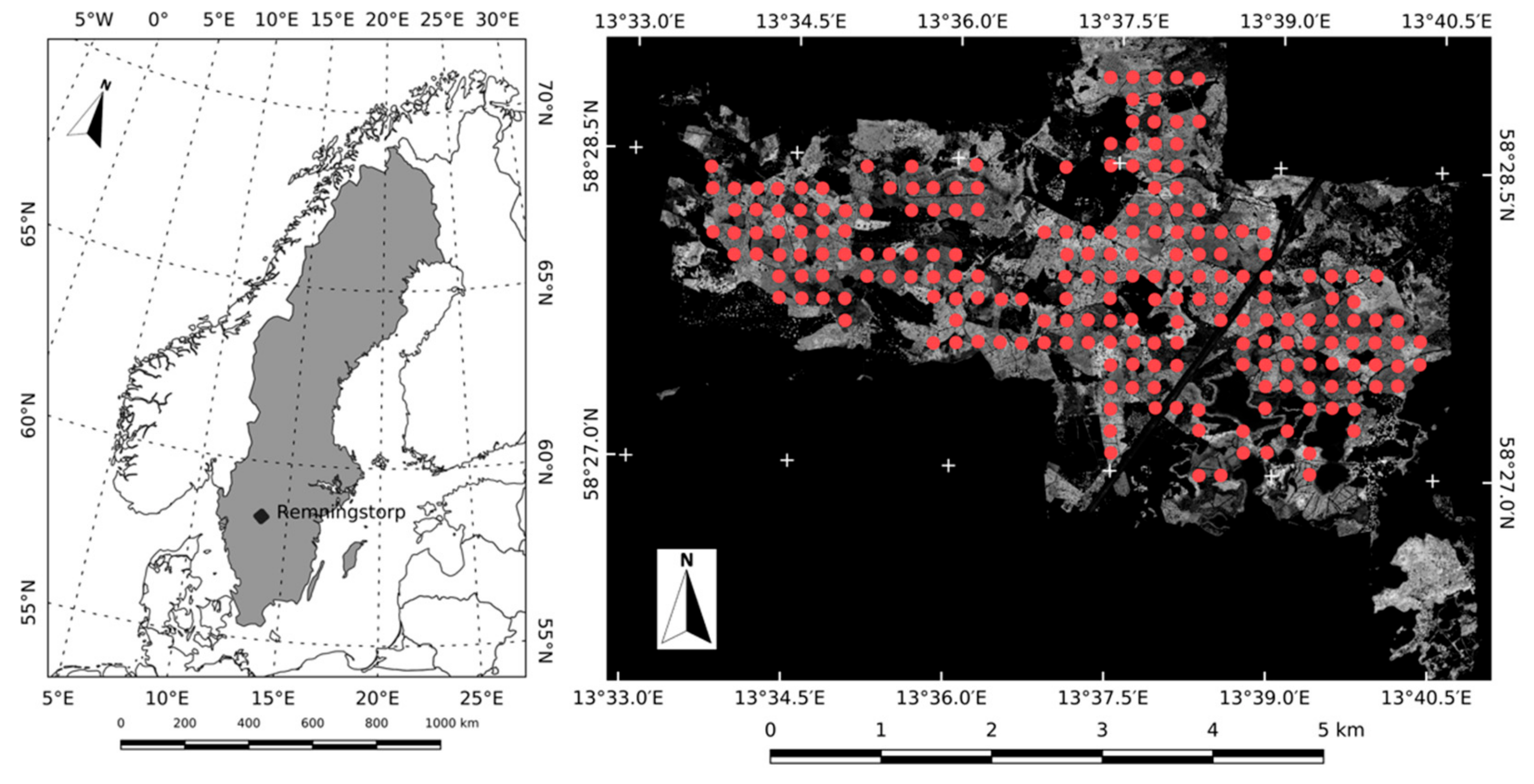
2. Study Area and Reference Data
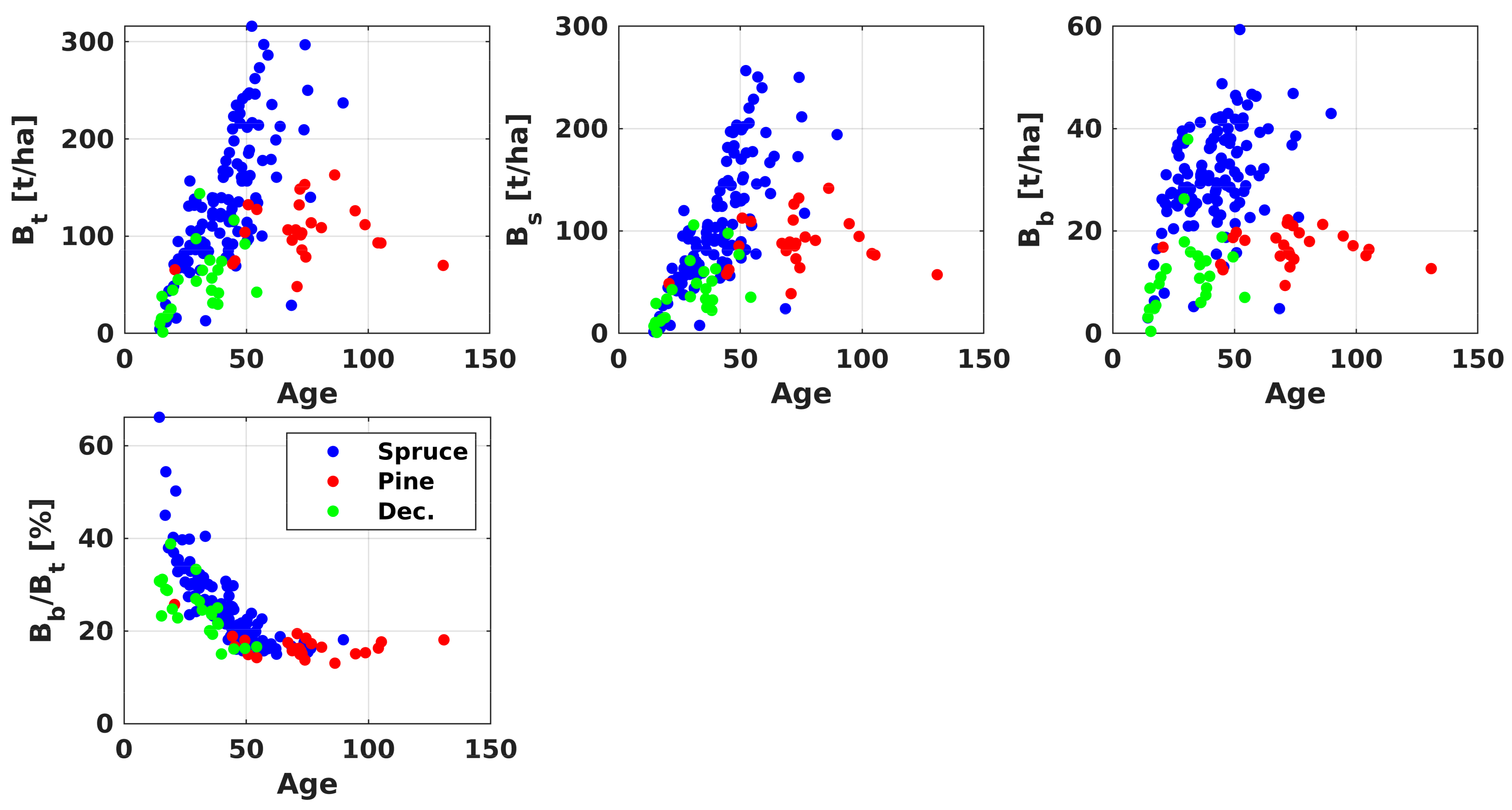
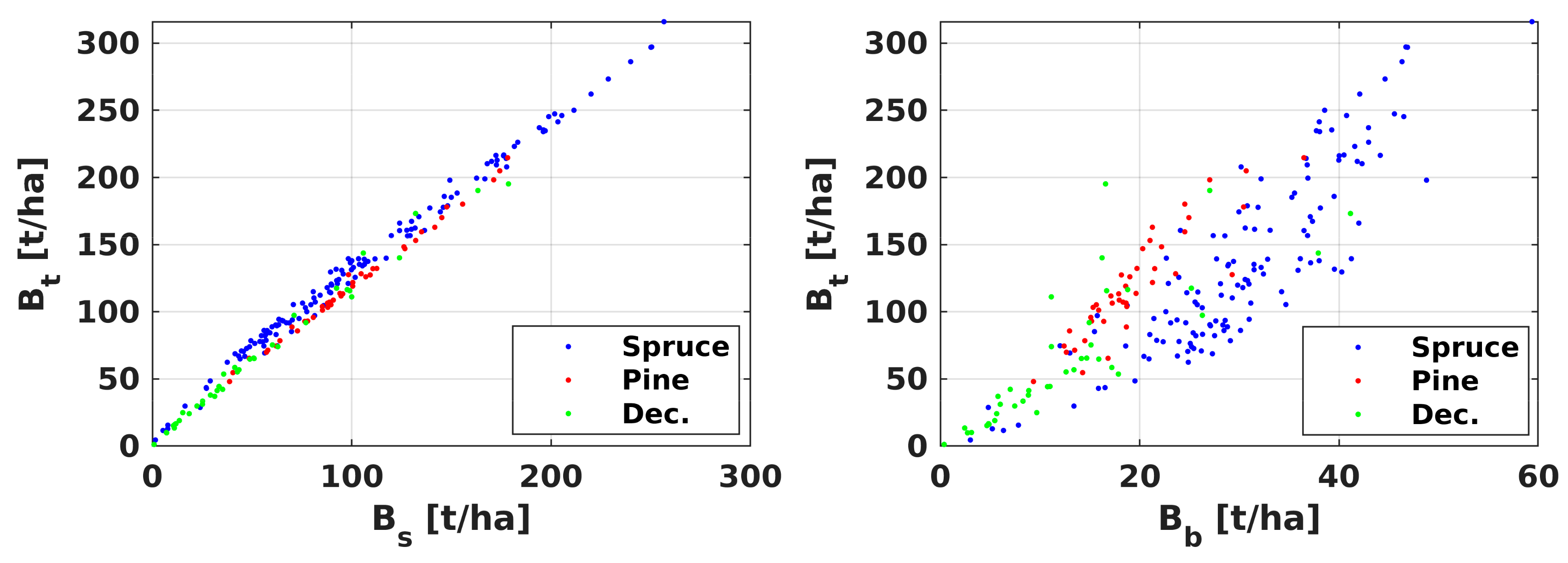
2.1. In Situ Data
2.2. LiDAR Data
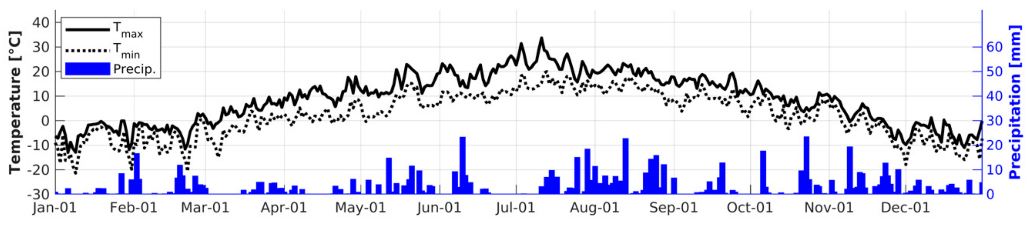
2.3. Weather Data
3. SAR Dataset
4. Methods
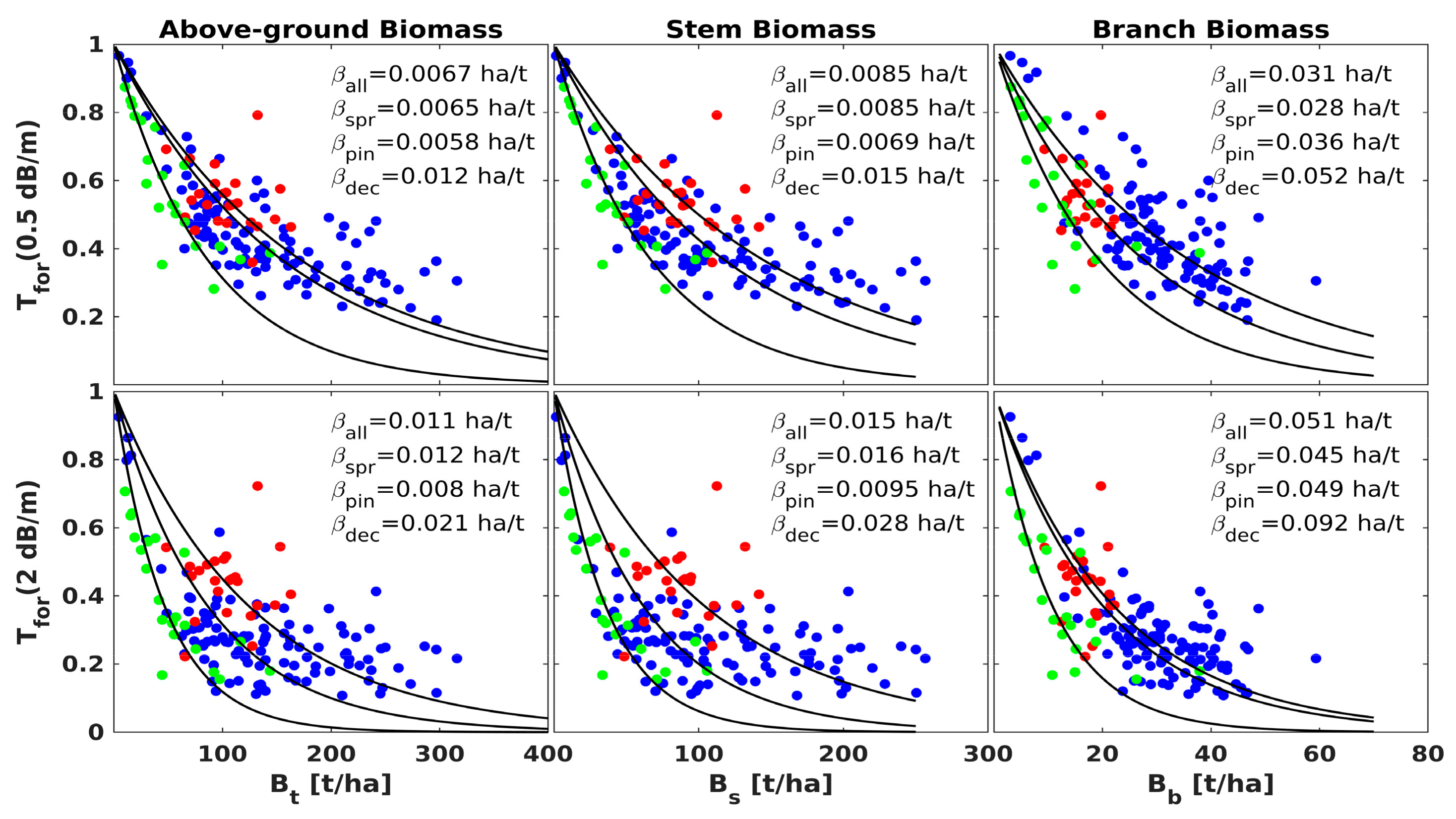
4.1. Retrieval Model for C- and L-Band Backscatter
4.2. Retrieval Model for P-Band Backscatter
4.3. Multi-Image Estimation of Biomass
4.4. Retrieval of Aboveground Biomass Via Estimates of Stem and Branch Biomass
5. Results
5.1. Model Calibration
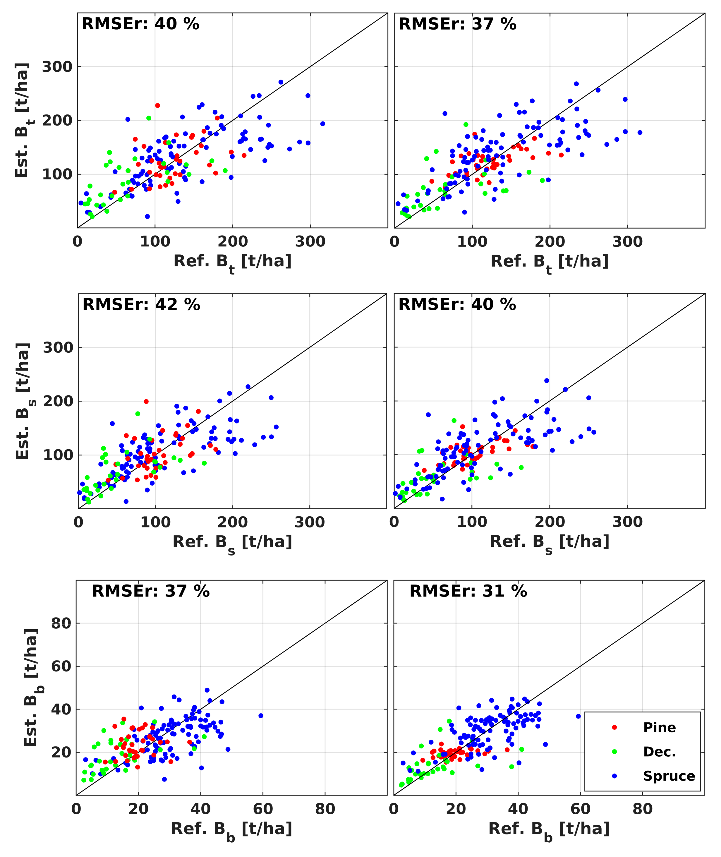
5.2. Retrieval of Above-Ground, Stem, and Branch Biomass
- for each scene in the multi-temporal stack of C-, L-, and P-band observations (Section 5.2.1),
- per frequency/polarization by combining all multi-temporal estimates from backscatter observations at a particular frequency/polarization (Section 5.2.2),
- for different frequency combinations (Section 5.2.3).
5.2.1. Single Image Retrieval
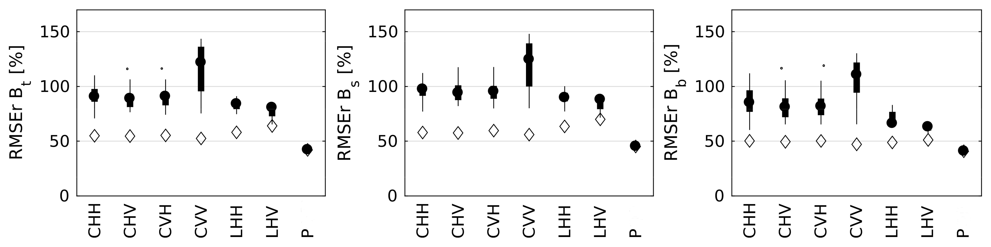
5.2.2. Multi-Temporal Retrieval
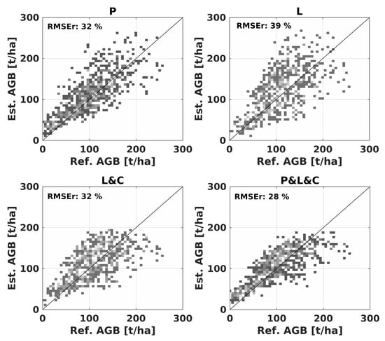
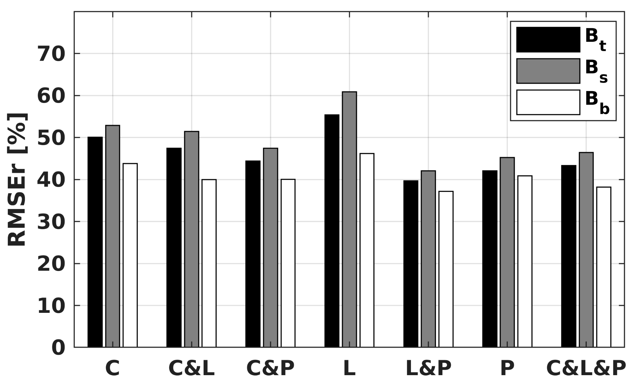
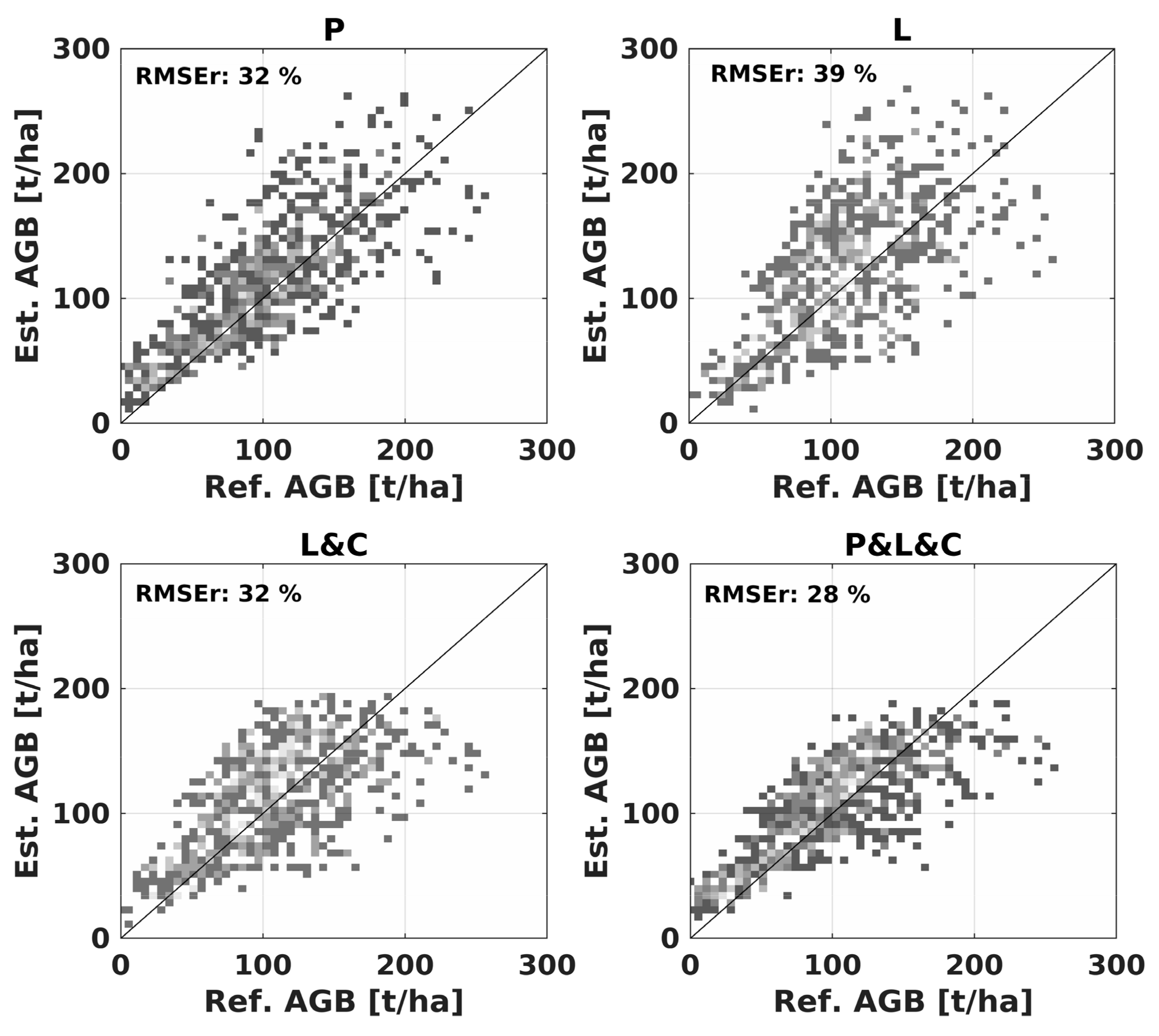
5.2.3. Multi-Frequency Retrieval
5.2.4. Retrieval per Species
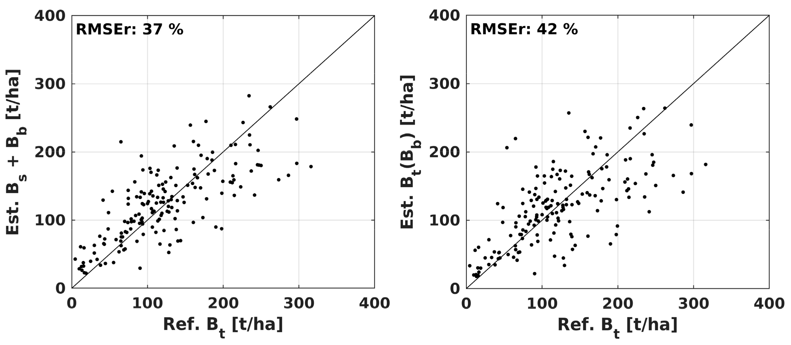
5.2.5. Direct vs Indirect Retrieval of Above-Ground Biomass
5.2.6. Comparison with LiDAR-Derived Above-Ground Biomass
6. Discussion
7. Conclusions
Supplementary Materials
Author Contributions
Funding
Acknowledgments
Conflicts of Interest
References
- Santoro, M.; Cartus, O. Pathways of forest above-ground biomass estimation with SAR backscatter and interferometric SAR observations. Remote Sens. 2018, 10, 608. [Google Scholar] [CrossRef]
- Bouvet, A.; Mermoz, S.; Le Toan, T.; Villard, L.; Mathieu, R.; Naidoo, L.; Asner, G.P. An above-ground biomass map of African savannahs and woodlands at 25 m resolution derived from ALOS PALSAR. Remote Sens. Environ. 2018, 206, 156–173. [Google Scholar] [CrossRef]
- Santoro, M.; Beaudoin, A.; Beer, C.; Cartus, O.; Fransson, J.E.S.; Hall, R.; Pathe, C.; Schepaschenko, D.; Schmullius, C.C.; Shvidenko, A.; et al. Forest growing stock volume of the northern hemisphere: Spatially explicit estimates for 2010 derived from Envisat ASAR data. Remote Sens. Environ. 2015, 168, 316–334. [Google Scholar] [CrossRef]
- Antropov, O.; Rauste, Y.; Häme, T.; Praks, J. Polarimetric ALOS PALSAR Time Series in Mapping Biomass of Boreal Forests. Remote Sens. 2017, 9, 999. [Google Scholar] [CrossRef]
- Quegan, S.; Le Toan, T.; Chave, J.; Dall, J.; Exbrayat, J.F.; Minh, D.H.T.; Rocca, F. The European Space Agency BIOMASS mission: Measuring forest above-ground biomass from space. Remote Sens. Environ. 2019, 227, 44–60. [Google Scholar] [CrossRef] [Green Version]
- Wang, Y.; Davis, F.W.; Melack, J.M. The effects of changes in forest biomass on radar backscatter from tree canopies. Int. J. Remote Sens. 1995, 16, 503–513. [Google Scholar] [CrossRef]
- Lucas, R.M.; Moghaddam, M.; Cronin, N. Microwave scattering from mixed-species forests, Queensland, Australia. IEEE Trans. Geosci. Remote Sens. 2004, 42, 2142–2159. [Google Scholar] [CrossRef]
- Chauhan, N.S.; Lang, R.; Ranson, K.J. Radar Modeling of a Boreal Forest. IEEE Trans. Geosci. Remote Sens. 2004, 29, 627–638. [Google Scholar] [CrossRef]
- Freeman, A.; Durden, S.L. A three-component scattering model for polarimetric SAR data. IEEE Trans. Geosci. Remote Sens. 1998, 36, 963–973. [Google Scholar] [CrossRef] [Green Version]
- Lang, R.; Chauhan, N.S.; Ranson, K.J.; Kilic, O. Modeling P-band SAR returns from a red pine stand. Remote Sens. Environ. 1994, 47, 132–141. [Google Scholar] [CrossRef]
- Ranson, K.J.; Sun, G. Northern forest classification using temporal multifrequency and multipolarimetric SAR images. Remote Sens. Environ. 1994, 47, 142–153. [Google Scholar] [CrossRef]
- Dobson, M.C.; Ulaby, F.T.; Pierce, L.E.; Sharik, T.L.; Bergen, K.M.; Kellndorfer, J.; Sarabandi, K. Estimation of Forest Biophysical Characteristics in Northern Michigan with SIR-C/X-SAR. IEEE Trans. Geosci. Remote Sens. 1995, 33, 877–895. [Google Scholar] [CrossRef]
- Harrell, P.A.; Bourgeau-Chavez, L.L.; Kasischke, E.S.; French, N.H.F.; Christensen, N.L. Sensitivity of ERS-1 and JERS-1 radar data to biomass and stand structure in Alaskan boreal forest. Remote Sens. Environ. 1995, 54, 247–260. [Google Scholar] [CrossRef]
- Kasischke, E.S.; Christensen, N.L.; Bourgeau-Chavez, L.L. Correlating Radar Backscatter with Components of Biomass in Loblolly Pine Forests. IEEE Trans. Geosci. Remote Sens. 1995, 33, 643–659. [Google Scholar] [CrossRef]
- Saatchi, S.S.; Halligan, K.; Despain, D.G.; Crabtree, R.L. Estimation of forest fuel load from radar remote sensing. IEEE Trans. Geosci. Remote Sens. 2007, 45, 1726–1740. [Google Scholar] [CrossRef]
- Kurvonen, L.; Pulliainen, J.T.; Hallikainen, M.T. Retrieval of biomass in boreal forests from multitempotal ERS-1 and JERS-1 SAR images. IEEE Trans. Geosci. Remote Sens. 1999, 37, 198–205. [Google Scholar] [CrossRef]
- Englhart, S.; Keuck, V.; Siegert, F. Aboveground biomass retrieval in tropical forests—The potential of combined X- and L-band SAR data use. Remote Sens. Environ. 2011, 115, 1260–1271. [Google Scholar] [CrossRef]
- Tsui, O.W.; Coops, N.C.; Wulder, M.A.; Marshall, P.L.; McCardle, A. Using multi-frequency radar and discrete-return LiDAR measurements to estimate above-ground biomass and biomass components in a coastal temperate forest. ISPRS J. Photogramm. Remote Sens. 2012, 69, 121–133. [Google Scholar] [CrossRef]
- Harrell, P.A.; Kasischke, E.S.; Bourgeau-Chavez, L.L.; Haney, E.M.; Christensen, N.L. Evaluation of approaches to estimating aboveground biomass in southern pine forests using SIR-C data. Remote Sens. Environ. 1997, 59, 223–233. [Google Scholar] [CrossRef]
- Santi, E.; Paloscia, S.; Pettinato, S.; Fontanelli, G.; Mura, M.; Zolli, C.; Chirici, G. The potential of multifrequency SAR images for estimating forest biomass in Mediterranean areas. Remote Sens. Environ. 2017, 200, 63–73. [Google Scholar] [CrossRef]
- Ranson, K.J.; Sun, G.; Weishampel, J.F.; Knox, R.G. Forest biomass from combined ecosystem and radar backscatter modeling. Remote Sens. Environ. 1997, 59, 118–133. [Google Scholar] [CrossRef]
- Kasischke, E.S.; Bourgeau-Chavez, L.L.; Christensen, N.L.; Haney, E.M. Observations on the sensitivity of ERS-1 sar image intensity to changes in aboveground biomass in young loblolly pine forests. Int. J. Remote Sens. 1994, 15, 3–16. [Google Scholar] [CrossRef]
- Askne, J.I.H.; Santoro, M.; Smith, G.; Fransson, J.E.S. Multitemporal repeat-pass SAR interferometry of boreal forests. IEEE Trans. Geosci. Remote Sens. 2003, 41, 1540–1550. [Google Scholar] [CrossRef]
- Pulliainen, J.T.; Mikkela, P.J.; Hallikainen, M.T.; Ikonen, J.P. Seasonal dynamics of C-band backscatter of boreal forests with applications to biomass and soil moisture estimation. IEEE Trans. Geosci. Remote Sens. 1996, 34, 758–770. [Google Scholar] [CrossRef]
- Ranson, K.J.; Sun, G. Effects of environmental conditions on boreal forest classification and biomass estimates with SAR. IEEE Trans. Geosci. Remote Sens. 2000, 38, 1242–1252. [Google Scholar] [CrossRef]
- Pulliainen, J.T.; Kurvonen, L.; Hallikainen, M.T. Multitemporal behavior of L-and C-band SAR observations of boreal forests. IEEE Trans. Geosci. Remote Sens. 1999, 37, 927–937. [Google Scholar] [CrossRef]
- Santoro, M.; Eriksson, L.E.B.; Askne, J.I.H.; Schmullius, C.C. Assessment of stand-wise stem volume retrieval in boreal forest from JERS-1 L-band SAR backscatter. Int. J. Remote Sens. 2006, 27, 3425–3454. [Google Scholar] [CrossRef]
- Santoro, M.; Fransson, J.E.S.; Eriksson, L.E.B.; Magnusson, M.; Ulander, L.M.H.; Olsson, H. Signatures of ALOS PALSAR L-band backscatter in Swedish Forest. IEEE Trans. Geosci. Remote Sens. 2009, 47, 4001–4019. [Google Scholar] [CrossRef]
- Santoro, M.; Eriksson, L.E.B.; Fransson, J.E.S. Reviewing ALOS PALSAR backscatter observations for stem volume retrieval in Swedish forest. Remote Sens. 2015, 7, 4290–4317. [Google Scholar] [CrossRef]
- Sandberg, G.; Ulander, L.M.H.; Fransson, J.E.S.; Holmgren, J.; Le Toan, T. L-and P-band backscatter intensity for biomass retrieval in hemiboreal forest. Remote Sens. Environ. 2011, 115, 2874–2886. [Google Scholar] [CrossRef]
- Soja, M.J.; Sandberg, G.; Ulander, L.M.H. Regression-based retrieval of boreal forest biomass in sloping terrain using P-band SAR backscatter intensity data. IEEE Trans. Geosci. Remote Sens. 2013, 51, 2646–2665. [Google Scholar] [CrossRef]
- Dubois-Fernandez, P.C.; Le Toan, T.; Daniel, S.; Oriot, H.; Chave, J.; Blanc, L.; Petit, M. The tropiSAR airborne campaign in French Guiana: Objectives, description, and observed temporal behavior of the backscatter signal. IEEE Trans. Geosci. Remote Sens. 2012, 50, 3228–3241. [Google Scholar] [CrossRef]
- Rignot, E.; Zimmermann, R.; van Zyl, J.J. Spaceborne Applications of P Band Imaging Radars for Measuring Forest Biomass. IEEE Trans. Geosci. Remote Sens. 1995, 33, 1162–1169. [Google Scholar] [CrossRef]
- Hajnsek, I.; Scheiber, R.; Ulander, L.; Gustavsson, A.; Sandberg, G.; Tebaldini, S.; Pardini, M. BIOSAR 2008 Technical Assistance for the Development of Airborne SAR and Geophysical Measurements during the BioSAR 2008 Experiment; Final Report; ESA: Paris, France, ESA Contract No. 20755/07/NL/CB; 2009. [Google Scholar]
- Ulander, L.M.H.; Gustavsson, A.; Flood, B.; Murdin, D.; Dubois-Fernandez, P.; Depuis, X.; Holmgren, J. BioSAR 2010–Technical Assictance for the Development of Airborne SAR and Geophysical Measurements during the BioSAR 2010 Experiment; Final Report; ESA: Paris, France, ESA Contract No.: 4000102285/10/NL/JA/ef; 2011. [Google Scholar]
- Petersson, H. Biomassafunktioner för trädfaktorer av tall, gran och björk i Sverige; Rapport 59; Sveriges lantbruksuniversistet Uppsala, Institutionen för Resurshushallning och Geomatik: Böblingen, Germany, 1999. [Google Scholar]
- Wegmüller, U. Automated terrain corrected SAR geocoding. In Proceedings of the IEEE 1999 International Geoscience and Remote Sensing Symposium, IGARSS’99, Hamburg, Germany, 28 June–2 July 1999. [Google Scholar]
- Frey, O.; Santoro, M.; Werner, C.L.; Wegmüller, U. DEM-Based SAR Pixel-Area Estimation for Enhanced Geocoding Refinement and Radiometric Normalization. IEEE Geosci. Remote Sens. Lett. 2013, 10, 48–52. [Google Scholar] [CrossRef]
- Quegan, S.; Yu, J.J. Multichannel Filtering of SAR Images. IEEE Trans. Geosci. Remote Sens. 2001, 39, 2371–2379. [Google Scholar] [CrossRef]
- Askne, J.I.H.; Dammert, P.B.G.; Ulander, L.M.H.; Smith, G. C-band repeat-pass interferometric SAR observations of the forest. IEEE Trans. Geosci. Remote Sens. 1997, 35, 25–35. [Google Scholar] [CrossRef]
- Imhoff, M.L. Radar backscatter and biomass saturation: Ramifications for global biomass inventory. IEEE Trans. Geosci. Remote Sens. 1995, 33, 511–518. [Google Scholar] [CrossRef]
- Breiman, L. Random forests. Mach. Learn. 2001, 45, 5–32. [Google Scholar] [CrossRef]
- Tanase, M.A.; Panciera, R.; Lowell, K.; Tian, S.Y.; Garcia-Martin, A.; Walker, J.P. Sensitivity of L-Band Radar Backscatter to Forest Biomass in Semiarid Environments: A Comparative Analysis of Parametric and Nonparametric Models. IEEE Trans. Geosci. Remote Sens. 2014, 52, 4671–4685. [Google Scholar] [CrossRef]
- Santoro, M.; Askne, J.I.H.; Smith, G.; Fransson, J.E.S. Stem volume retrieval in boreal forests from ERS-1 / 2 interferometry. Remote Sens. Environ. 2002, 81, 19–35. [Google Scholar] [CrossRef]
- Santoro, M.; Cartus, O.; Fransson, J.E.S.; Wegmüller, U. Complementarity of X-, C-and L-band SAR backscatter observations to retrieve forest stem volume. Remote Sens. 2019, 11, 1563. [Google Scholar] [CrossRef]
- Cartus, O.; Santoro, M.; Schmullius, C.C.; Li, Z. Large area forest stem volume mapping in the boreal zone using synergy of ERS-1/2 tandem coherence and MODIS vegetation continuous fields. Remote Sens. Environ. 2011, 115, 931–943. [Google Scholar] [CrossRef]
- Santoro, M.; Shvidenko, A.; McCallum, I.; Askne, J.I.H.; Schmullius, C.C. Properties of ERS-1/2 coherence in the Siberian boreal forest and implications for stem volume retrieval. Remote Sens. Environ. 2007, 106, 154–172. [Google Scholar] [CrossRef]
- Cartus, O.; Santoro, M.; Kellndorfer, J.M. Mapping forest aboveground biomass in the Northeastern United States with ALOS PALSAR dual-polarization L-band. Remote Sens. Environ. 2012, 124, 466–478. [Google Scholar] [CrossRef]
- Newman, M.C. Regression analysis of log-transformed data: Statistical bias and its correction. Environ. Toxicol. Chem. 1993, 12, 1129–1133. [Google Scholar] [CrossRef]
- Praks, J.; Antropov, O.; Hallikainen, M.T. LIDAR Aided SAR Interferometry Studies in Boreal Forest: Phase Center and Extinction Coefficient at X- and L-band. Trans. Geosci. Remote Sens. 2011, 50, 3831–3843. [Google Scholar] [CrossRef]
- Askne, J.I.H.; Santoro, M. Multitemporal repeat pass SAR interferometry of boreal forests. IEEE Trans. Geosci. Remote Sens. 2005, 43, 1219–1228. [Google Scholar] [CrossRef]
- Santoro, M.; Beer, C.; Cartus, O.; Schmullius, C.; Shvidenko, A.; McCallum, I.; Wiesmann, A. Retrieval of growing stock volume in boreal forest using hyper-temporal series of Envisat ASAR ScanSAR backscatter measurements. Remote Sens. Environ. 2011, 115, 490–507. [Google Scholar] [CrossRef]
- Antropov, O.; Rauste, Y.; Ahola, H.; Häme, T. Stand-level stem volume of boreal forests from spaceborne SAR imagery at L-band. IEEE J. Sel. Top. Appl. Earth Observ. Remote Sens. 2013, 6, 35–44. [Google Scholar] [CrossRef]
- Peregon, A.; Yamagata, Y. The use of ALOS/PALSAR backscatter to estimate above-ground forest biomass: A case study in Western Siberia. Remote Sens. Environ. 2013, 137, 139–146. [Google Scholar] [CrossRef]
- Carreiras, J.M.B.; Quegan, S.; Le Toan, T.; Ho Tong Minh, D.; Saatchi, S.S.; Carvalhais, N.; Reichstein, M.; Scipal, K. Coverage of high biomass forests by the ESA BIOMASS mission under defense restrictions. Remote Sens. Environ. 2015, 196, 154–162. [Google Scholar] [CrossRef]


| Band | Sensor | Polarization | Look Angle | Ground-Range and Azimuth Resolution | No. | Acquisition Months |
|---|---|---|---|---|---|---|
| C | ERS-2 | VV | 23° | 25 m × 4 m | 17 | 1,3–12 |
| C | RADARSAT-2 | HH, HV, VH, VV | 21–41° | 7–13 m × 5 m | 25 | 1,2,3,11,12 |
| L | ALOS PALSAR | HH HH, HV | 34° 34° | 8 m × 3 m 15 m × 3 m | 2 4 | 1,2 8,9,10 |
| P | SETHI | HH, HV, VH, VV | 24–62° | 0.9–2 m × 0.8 m | 1 | 9 |
© 2019 by the authors. Licensee MDPI, Basel, Switzerland. This article is an open access article distributed under the terms and conditions of the Creative Commons Attribution (CC BY) license (http://creativecommons.org/licenses/by/4.0/).
Share and Cite
Cartus, O.; Santoro, M.; Wegmüller, U.; Rommen, B. Benchmarking the Retrieval of Biomass in Boreal Forests Using P-Band SAR Backscatter with Multi-Temporal C- and L-Band Observations. Remote Sens. 2019, 11, 1695. https://0-doi-org.brum.beds.ac.uk/10.3390/rs11141695
Cartus O, Santoro M, Wegmüller U, Rommen B. Benchmarking the Retrieval of Biomass in Boreal Forests Using P-Band SAR Backscatter with Multi-Temporal C- and L-Band Observations. Remote Sensing. 2019; 11(14):1695. https://0-doi-org.brum.beds.ac.uk/10.3390/rs11141695
Chicago/Turabian StyleCartus, Oliver, Maurizio Santoro, Urs Wegmüller, and Björn Rommen. 2019. "Benchmarking the Retrieval of Biomass in Boreal Forests Using P-Band SAR Backscatter with Multi-Temporal C- and L-Band Observations" Remote Sensing 11, no. 14: 1695. https://0-doi-org.brum.beds.ac.uk/10.3390/rs11141695