
Mapping Mature Post-Agricultural Forests in the Polish Eastern Carpathians with Archival Remote Sensing Data


Abstract
:1. Introduction
2. Methods
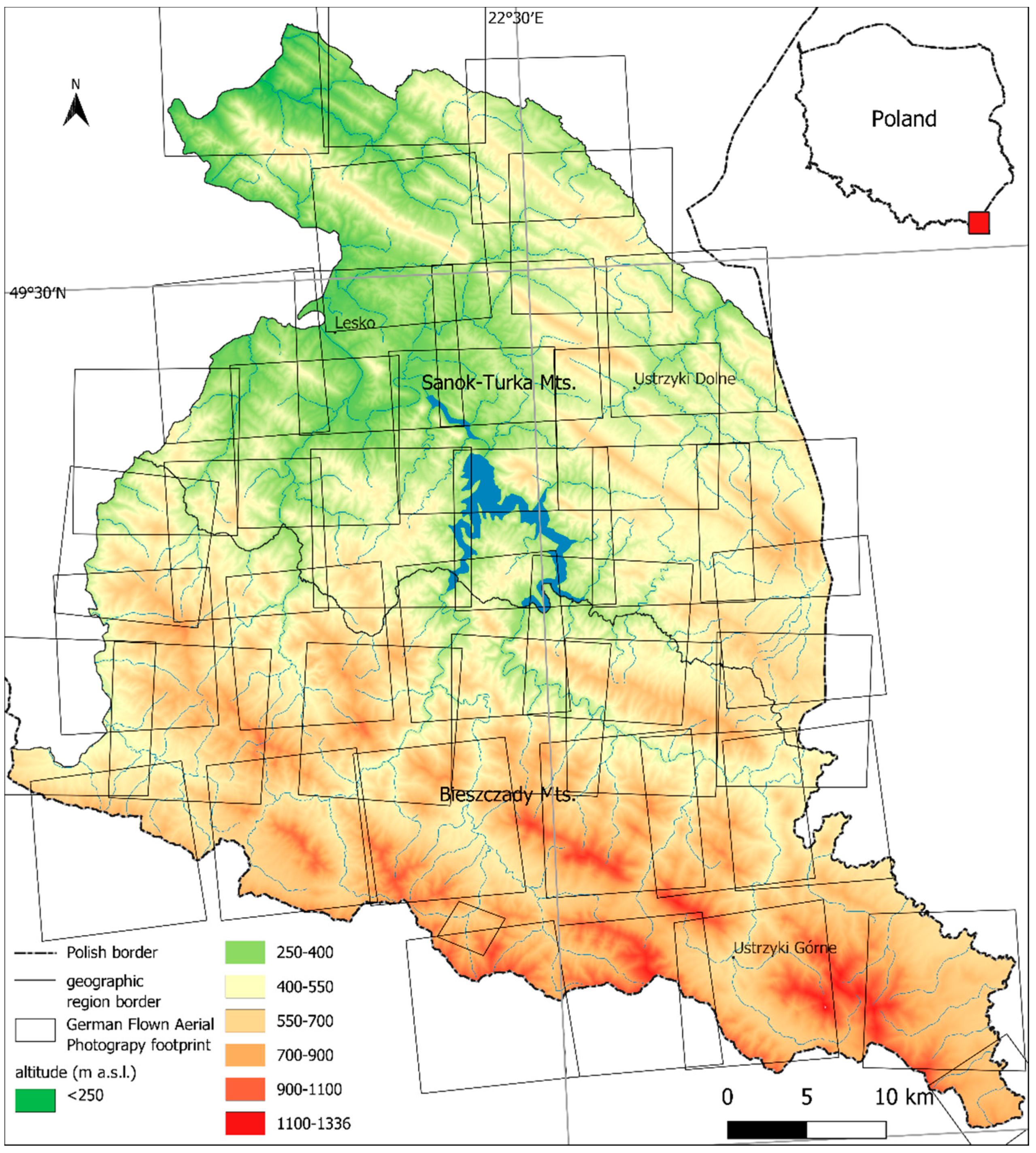
2.1. Study Area
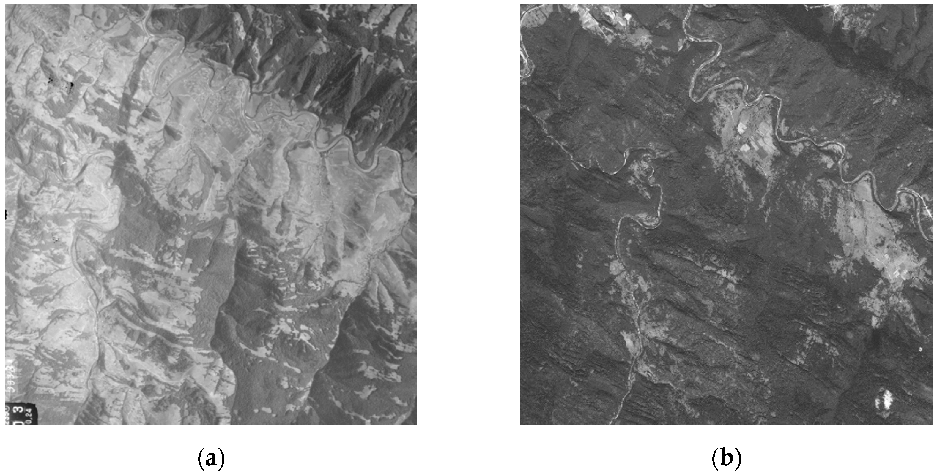
2.2. Remote Sensing Data
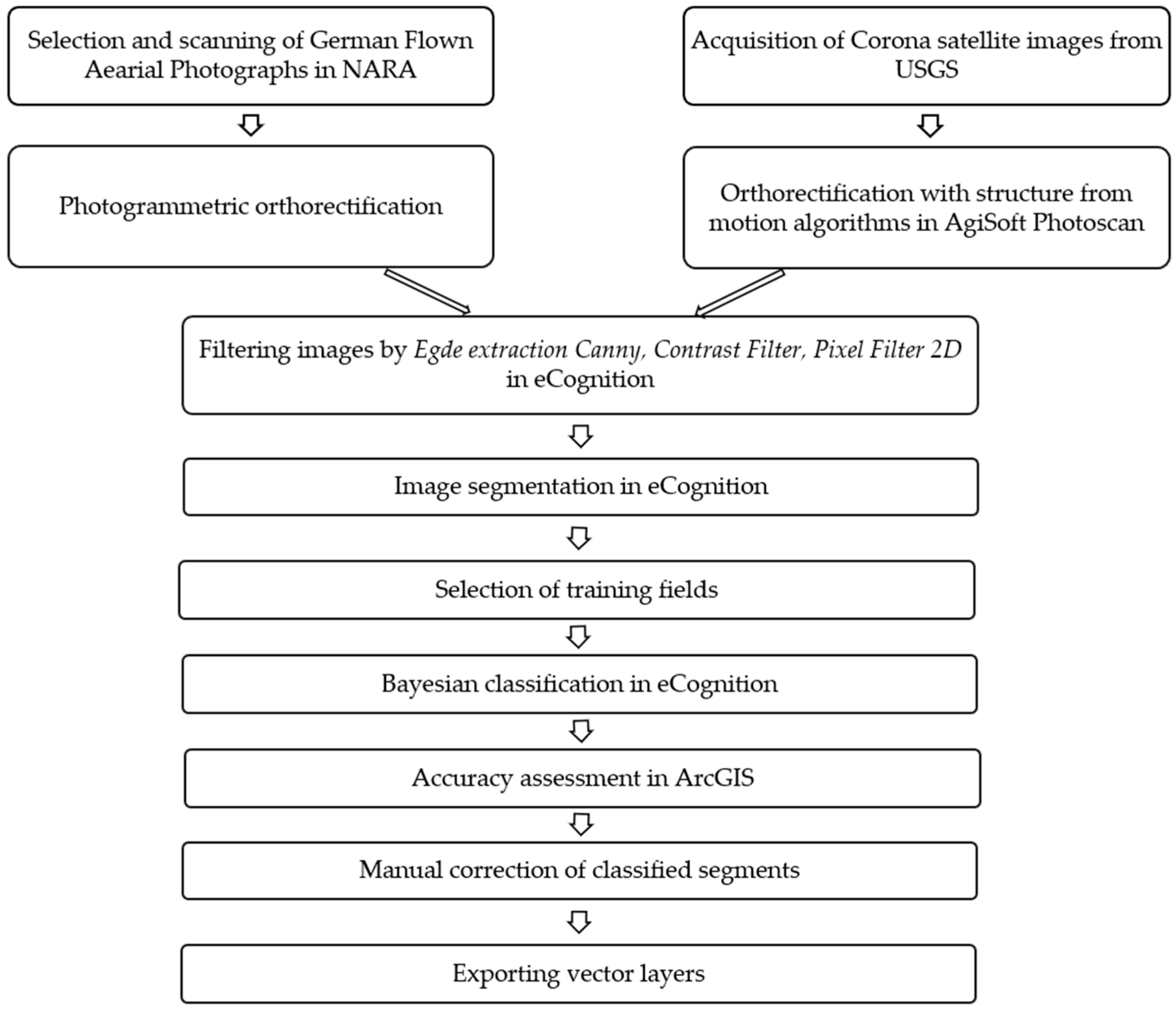
2.3. Data Processing
2.4. Spatial Analysis
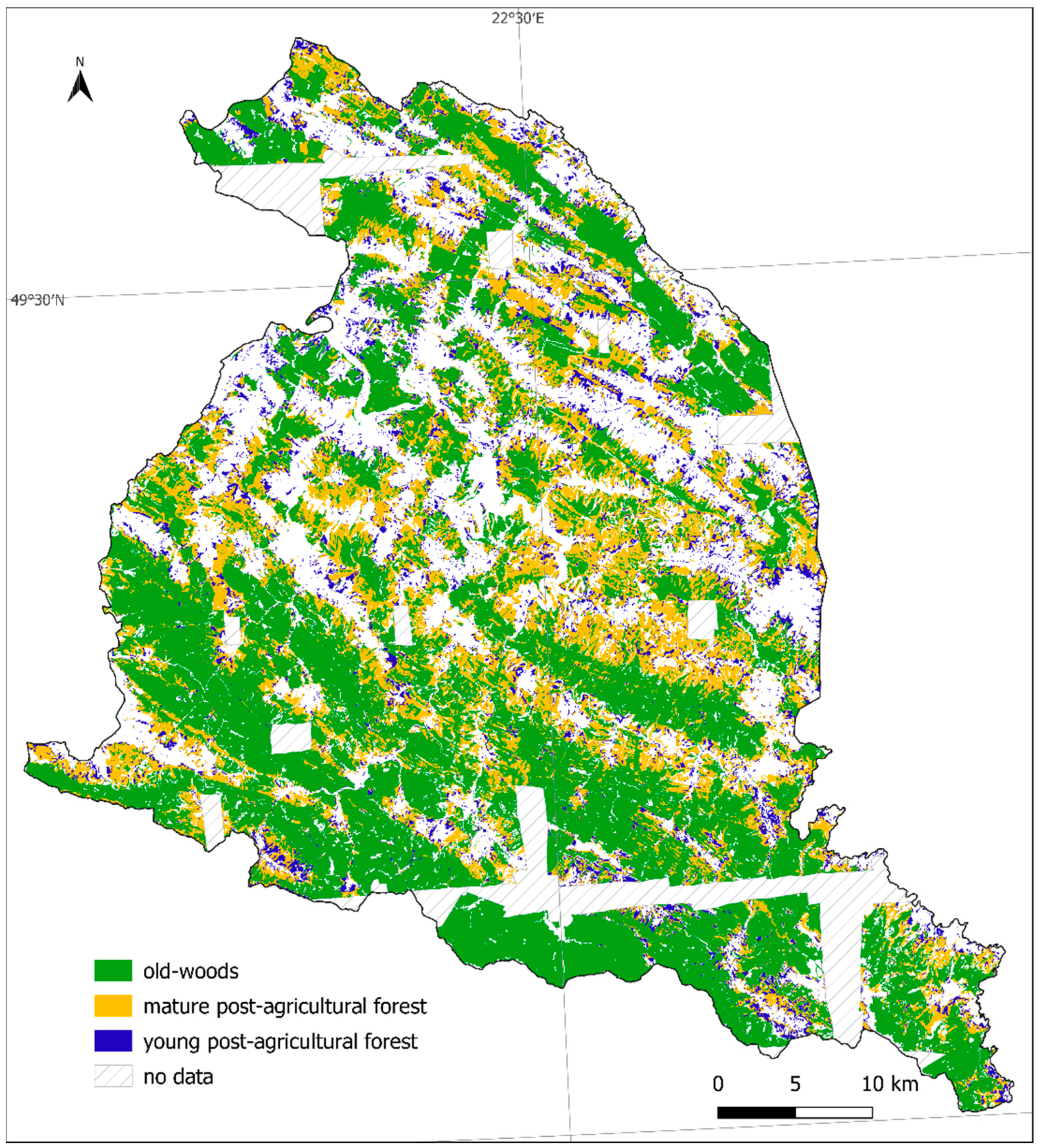
- Old-woods (after Singleton et al. [50])—forests that existed before the displacement and most likely have never been cleared for agriculture;
- Mature post-agricultural forest (after Singleton et al. [50])—stands currently in the age of 60–70, with closed canopies that had developed on land abandoned from agriculture in the 1940s;
- Young post-agricultural forest—forest that developed on former farmlands after 1969.
3. Results
4. Discussion
Supplementary Materials
Author Contributions
Funding
Data Availability Statement
Acknowledgments
Conflicts of Interest
References
- Flinn, K.M.; Vellend, M. Recovery of forest plant communities in post-agricultural landscapes. Front. Ecol. Environ. 2005, 3, 243–250. [Google Scholar] [CrossRef]
- Bergès, L.; Dupouey, J.L. Historical ecology and ancient forests: Progress, conservation issues and scientific prospects, with some examples from the French case. J. Veg. Sci. 2019, 1–17. [Google Scholar] [CrossRef]
- Matuszkiewicz, J.M.; Kowalska, A.; Kozłowska, A.; Roo-Zielińska, E.; Solon, J. Differences in plant-species composition, richness and community structure in ancient and post-agricultural pine forests in central Poland. For. Ecol. Manag. 2013, 310, 567–576. [Google Scholar] [CrossRef] [Green Version]
- D’Orangeville, L.; Bouchard, A.; Cogliastro, A. Post-agricultural forests: Landscape patterns add to stand-scale factors in causing insufficient hardwood regeneration. For. Ecol. Manag. 2008, 255, 1637–1646. [Google Scholar] [CrossRef]
- Naaf, T.; Kolk, J. Colonization credit of post-agricultural forest patches in NE Germany remains 130–230 years after reforestation. Biol. Conserv. 2015, 182, 155–163. [Google Scholar] [CrossRef] [Green Version]
- Estel, S.; Kuemmerle, T.; Alcántara, C.; Levers, C.; Prishchepov, A.; Hostert, P. Mapping farmland abandonment and recultivation across Europe using MODIS NDVI time series. Remote Sens. Environ. 2015, 163, 312–325. [Google Scholar] [CrossRef]
- Alcantara, C.; Kuemmerle, T.; Prishchepov, A.V.; Radeloff, V.C. Mapping abandoned agriculture with multi-temporal MODIS satellite data. Remote Sens. Environ. 2012, 124, 334–347. [Google Scholar] [CrossRef]
- Rendenieks, Z.; Nita, M.D.; Nikodemus, O.; Radeloff, V.C. Half a century of forest cover change along the Latvian-Russian border captured by object-based image analysis of Corona and Landsat TM/OLI data. Remote Sens. Environ. 2020, 249, 1–14. [Google Scholar] [CrossRef]
- Kozak, J.; Estreguil, C.; Troll, M. Forest cover changes in the northern Carpathians in the 20th century: A slow transition. J. Land Use Sci. 2007, 2, 127–146. [Google Scholar] [CrossRef]
- Matuszkiewicz, J.M.; Kowalska, A.; Solon, J.; Degórski, M.; Kozłowska, A.; Roo-Zielińska, E.; Zawiska, I.; Wolski, J. Long-Term Evolution Models of Post-Agricultural Forests; Institute of Geography and Spatial Organization Polish Academy of Sciences: Warsaw, Poland, 2013; Volume 240, ISBN 9788361590293. [Google Scholar]
- Kopecký, M.; Vojta, J. Land use legacies in post-agricultural forests in the Doupovské Mountains, Czech Republic. Appl. Veg. Sci. 2009, 12, 251–260. [Google Scholar] [CrossRef]
- Sciama, D.; Augusto, L.; Dupouey, J.-L.; Gonzalez, M.; Moares Domínguez, C. Floristic and ecological differences between recent and ancient forests growing on non-acidic soils. For. Ecol. Manag. 2009, 258, 600–608. [Google Scholar] [CrossRef]
- Dupouey, J.L.; Dambrine, E.; Laffite, J.D.; Moares, C. Irreversible Impact of Past Land Use on Forest Soils and Biodiversity. Ecology 2002, 83, 2978–2984. [Google Scholar] [CrossRef]
- Bailey, S. Increasing connectivity in fragmented landscapes: An investigation of evidence for biodiversity gain in woodlands. For. Ecol. Manag. 2007, 238, 7–23. [Google Scholar] [CrossRef]
- UNEP. Frontiers 2017 Emerging Issues of Environmental Concern; UNEP: Nairobi, Kenya, 2017.
- Ammer, C.; Fichtner, A.; Fischer, A.; Gossner, M.M.; Meyer, P.; Seidl, R.; Thomas, F.M.; Annighöfer, P.; Kreyling, J.; Ohse, B.; et al. Key ecological research questions for Central European forests. Basic Appl. Ecol. 2018, 32, 3–25. [Google Scholar] [CrossRef]
- Kuhman, T.R.; Pearson, S.M.; Turner, M.G. Agricultural land-use history increases non-native plant invasion in a southern Appalachian forest a century after abandonment. Can. J. For. Res. 2011, 41, 920–929. [Google Scholar] [CrossRef]
- Ito, S.; Nakayama, R.; Buckley, G.P. Effects of previous land-use on plant species diversity in semi-natural and plantation forests in a warm-temperate region in southeastern Kyushu, Japan. For. Ecol. Manag. 2004, 196, 213–225. [Google Scholar] [CrossRef]
- Munteanu, C.; Kuemmerle, T.; Boltiziar, M.; Butsic, V.; Gimmi, U.; Halada, L.; Kaim, D.; Király, G.; Konkoly-Gyuró, É.; Kozak, J.; et al. Forest and agricultural land change in the Carpathian region—A meta-analysis of long-term patterns and drivers of change. Land Use Policy 2014, 38, 685–697. [Google Scholar] [CrossRef]
- Eberhardt, P. Political Migrations on Polish Territories (1939–1950); Institute of Geography and Spatial Organization Polish Academy of Sciences: Warsaw, Poland, 2011. [Google Scholar]
- Korzeniak, J.; Kucharzyk, S. Zmiany w szacie roślinnej od połowy XIX w. do czasów współczesnych. In Bojkowszczyzna Zachodnia—Wczoraj, Dziś i Jutro, Tom II; Wolski, J., Ed.; Institute of Geography and Spatial Organization Polish Academy of Sciences: Warsaw, Poland, 2016. [Google Scholar]
- Affek, A.N.; Wolski, J.; Zachwatowicz, M.; Ostafin, K.; Radeloff, V.C. Effects of post-WWII forced displacements on long-term landscape dynamics in the Polish Carpathians. Landsc. Urban Plan. 2021. in review. [Google Scholar]
- Kaim, D.; Kozak, J.; Ostafin, K.; Dobosz, M.; Ostapowicz, K.; Kolecka, N.; Gimmi, U. Uncertainty in historical land-use reconstructions with topographic maps. Quaest. Geogr. 2014, 33, 55–63. [Google Scholar] [CrossRef] [Green Version]
- Okeke, F.; Karnieli, A. Methods for fuzzy classification and accuracy assessment of historical aerial photographs for vegetation change analyses. Part II: Practical application. Int. J. Remote Sens. 2006, 27, 1825–1838. [Google Scholar] [CrossRef]
- Morgan, J.L.; Gergel, S.E. Automated analysis of aerial photographs and potential for historic forest mapping. Can. J. For. Res. 2013, 43, 699–710. [Google Scholar] [CrossRef]
- Jucha, W.; Franczak, P.; Sadowski, P. Detection of World War II field fortifications using ALS and archival aerial images—German OKH Stellung b1 trenches in the south of the Polish Carpathians. Archaeol. Prospect. 2020, 1–11. [Google Scholar] [CrossRef]
- Cots-Folch, R.; Aitkenhead, M.J.; Martínez-Casasnovas, J.A. Mapping land cover from detailed aerial photography data using textural and neural network analysis. Int. J. Remote Sens. 2007, 28, 1625–1642. [Google Scholar] [CrossRef]
- Hossain, M.D.; Chen, D. Segmentation for Object-Based Image Analysis (OBIA): A review of algorithms and challenges from remote sensing perspective. ISPRS J. Photogramm. Remote Sens. 2019, 150, 115–134. [Google Scholar] [CrossRef]
- Blaschke, T. Object based image analysis for remote sensing. ISPRS J. Photogramm. Remote Sens. 2010, 65, 2–16. [Google Scholar] [CrossRef] [Green Version]
- Blackman, R.; Yuan, F. Detecting Long-Term Urban Forest Cover Change and Impacts of Natural Disasters Using High-Resolution Aerial Images and LiDAR Data. Remote Sens. 2020, 12, 1820. [Google Scholar] [CrossRef]
- Pinto, A.T.; Gonçalves, J.A.; Beja, P.; Pradinho Honrado, J. From Archived Historical Aerial Imagery to Informative Orthophotos: A Framework for Retrieving the Past in Long-Term Socioecological Research. Remote Sens. 2019, 11, 1388. [Google Scholar] [CrossRef] [Green Version]
- Nita, M.D.; Munteanu, C.; Gutman, G.; Abrudan, I.V.; Radeloff, V.C. Widespread forest cutting in the aftermath of World War II captured by broad-scale historical Corona spy satellite photography. Remote Sens. Environ. 2018, 204, 322–332. [Google Scholar] [CrossRef]
- Jabs, Z.J. Uwarunkowania i Kierunki Przekształceń Dawnych Pól Ornych po Wysiedleniach Lat 40. XX Wieku w Beskidach. (Determinants and Directions of Changes of Former Farmlands after Population Displacement in the 1940s in the Beskid Mountains). Master’s Thesis, University of Warsaw, Warsaw, Poland, 2019. [Google Scholar]
- USGS. USGS EROS Archive—Declassified Data—Declassified Satellite Imagery—3. Available online: https://www.usgs.gov/centers/eros/science/usgs-eros-archive-declassified-data-declassified-satellite-imagery-1?qt-science_center_objects=0#qt-science_center_objects (accessed on 12 October 2020).
- Tappan, G.G.; Hadj, A.; Wood, E.C.; Lietzow, R.W. Use of Argon, Corona, and Landsat imagery to assess 30 years of land resource changes in west-central Senegal. Photogramm. Eng. Remote Sens. 2000, 66, 727–735. [Google Scholar]
- Song, D.X.; Huang, C.; Sexton, J.O.; Channan, S.; Feng, M.; Townshend, J.R. Use of Landsat and Corona data for mapping forest cover change from the mid-1960s to 2000s: Case studies from the Eastern United States and Central Brazil. ISPRS J. Photogramm. Remote Sens. 2015, 103, 81–92. [Google Scholar] [CrossRef] [Green Version]
- Solon, J.; Borzyszkowski, J.; Bidłasik, M.; Richling, A.; Badora, K.; Balon, J.; Brzezińska-Wójcik, T.; Chabudziński, Ł.; Dobrowolski, R.; Grzegorczyk, I.; et al. Physico-geographical mesoregions of Poland: Verification and adjustment of boundaries. Geogr. Pol. 2018, 91, 143–170. [Google Scholar] [CrossRef]
- Szafer, W.; Zarzycki, K. Szata Roślinna Polski: Opracowanie Zbiorowe; Państwowe Wydawnictwo Naukowe: Warsaw, Poland, 1972. [Google Scholar]
- UNEP. Carpathians Environment Outlook; United Nations Environment Programme: Geneva, Switzerland, 2007; ISBN 9789280728361.
- Nowosad, M. Warunki klimatyczne. In Bojkowszczyzna Zachodnia Wczoraj, Dziś i Jutro. Tom I; Wolski, J., Ed.; Institute of Geography and Spatial Organization Polish Academy of Sciences: Warsaw, Poland, 2016. [Google Scholar]
- Haczewski, G.; Kukulak, J. Budowa geologiczna i rzeźba terenu. In Bojkowszczyzna Zachodnia Wczoraj, Dziś i Jutro, Tom I; Wolski, J., Ed.; Institute of Geography and Spatial Organization Polish Academy of Sciences: Warsaw, Poland, 2016. [Google Scholar]
- Skiba, S.; Drewnik, M. Mapa gleb obszaru Karpat w granicach Polski. Rocz. Bieszcz. 2003, 11, 15–20. [Google Scholar]
- Sohn, H.-G.; Kim, G.-H.; Yom, J.-H. Mathematical modelling of historical reconnaissance CORONA KH-4B Imagery. Photogramm. Rec. 2004, 19, 51–66. [Google Scholar] [CrossRef]
- United States Geological Survey USGS EROS Archive—Sentinel-2. Available online: https://www.usgs.gov/centers/eros/science/usgs-eros-archive-sentinel-2?qt-science_center_objects=0#qt-science_center_objects (accessed on 20 April 2020).
- Baltsavias, E.P. Digital ortho-images—A powerful tool for the extraction of spatial- and geo-information. ISPRS J. Photogramm. Remote Sens. 1996, 51, 63–77. [Google Scholar] [CrossRef]
- Karwel, K. Ocena dokładności modelu SRTM-X na obszarze Polski (Estimation of accuracy of SRTM-X terrain model on Polish area). Archiwum Fotogrametrii Kartografii i Teledetekcji 2012, 23, 139–145. [Google Scholar]
- Trimble Geospatial. Welcome to eCognition 10. 2020. Available online: https://geospatial.trimble.com/blog/welcome-ecognition-10 (accessed on 18 May 2021).
- Gelman, A.; Carlin, J.B.; Stern, H.S.; Dunson, D.B.; Vehtari, A.; Rubin, D.B. Bayesian Data Analysis; CRC Press: London, UK, 2004. [Google Scholar]
- Condego, L. Semi-Automatic Classification Plugin Documentation 2010. Release 2016, 4, 29. [Google Scholar] [CrossRef]
- Singleton, R.; Gardescu, S.; Marks, P.L.; Geber, M.A. Forest herb colonization of postagricultural forests in central New York State, USA. J. Ecol. 2001, 89, 325–338. [Google Scholar] [CrossRef] [Green Version]
- QGIS Development Team. Changelog for QGIS 3.10. 2020. Available online: https://www.qgis.org/en/site/forusers/visualchangelog310/index.html (accessed on 18 May 2021).
- ESRI Arcgis Pro. Available online: https://pro.arcgis.com/en/pro-app/latest/tool-reference/analysis/near.htm (accessed on 20 February 2021).
- MacGarigal, K.; Marks, B.J. FRAGSTATS: Spatial Pattern Analysis Program for Quantifying Landscape Structure; General Technical Report; U.S. Department of Agriculture, Forest Service, Pacific Northwest Research Station: Portland, OR, USA, 1995.
- U.S. Geological Survey Aerial Photographs and Satellite Images—Online Edition. Available online: http://egsc.usgs.gov/isb/pubs/booklets/aerial/aerial.html (accessed on 15 January 2020).
- Baumann, M.; Kuemmerle, T. The impacts of warfare and armed conflict on land systems. J. Land Use Sci. 2016, 11, 672–688. [Google Scholar] [CrossRef]
- Munteanu, C.; Nita, M.D.; Abrudan, I.V.; Radeloff, V.C. Historical forest management in Romania is imposing strong legacies on contemporary forests and their management. For. Ecol. Manag. 2016, 361, 179–193. [Google Scholar] [CrossRef]
- Lourenço, P.; Teodoro, A.C.; Gonçalves, J.A.; Honrado, J.P.; Cunha, M.; Sillero, N. Assessing the performance of different OBIA software approaches for mapping invasive alien plants along roads with remote sensing data. Int. J. Appl. Earth Obs. Geoinf. 2021, 95, 1–11. [Google Scholar] [CrossRef]
- Turner, M.G.; Pearson, S.M.; Bolstad, P.; Wear, D.N. Effects of land-cover change on spatial pattern of forest communities in the Southern Appalachian Mountains (USA). Landsc. Ecol. 2003, 18, 449–464. [Google Scholar] [CrossRef]
- Foster, D.R.; Motzkin, G.; Slater, B. Land-Use History as Long-Term Broad-Scale Disturbance: Regional Forest Dynamics in Central New England. Ecosystems 1998, 1, 96–119. [Google Scholar] [CrossRef]
- Grashof-Bokdam, C.J.; Geertsema, W. The Effect of Isolation and History on Colonization Patterns of Plant Species in Secondary Woodland. J. Biogeogr. 1998, 25, 837–846. [Google Scholar] [CrossRef]
- Gellrich, M.; Zimmermann, N.E. Investigating the regional-scale pattern of agricultural land abandonment in the Swiss mountains: A spatial statistical modelling approach. Landsc. Urban Plan. 2007, 79, 65–76. [Google Scholar] [CrossRef]
- Griffiths, P.; Müller, D.; Kuemmerle, T.; Hostert, P. Agricultural land change in the Carpathian ecoregion after the breakdown of socialism and expansion of the European Union. Environ. Res. Lett. 2013, 8, 1–12. [Google Scholar] [CrossRef]
- Prishchepov, A.A.; Müller, D.; Dubinin, M.; Baumann, M.; Radeloff, V.C. Determinants of agricultural land abandonment in post-Soviet European Russia. Land Use Policy 2013, 30, 873–884. [Google Scholar] [CrossRef] [Green Version]
- Pazúr, R.; Lieskovský, J.; Feranec, J.; Oťaheľ, J. Spatial determinants of abandonment of large-scale arable lands and managed grasslands in Slovakia during the periods of post-socialist transition and European Union accession. Appl. Geogr. 2014, 54, 118–128. [Google Scholar] [CrossRef]
- Affek, A.N.; Zachwatowicz, M.; Solon, J. Long-term landscape dynamics in the depopulated Carpathian Foothills: A Wiar River basin case study. Geogr. Pol. 2020, 93, 5–23. [Google Scholar] [CrossRef] [Green Version]
- Kozak, J. Forest Cover Change in the Western Carpathians in the Past 180 Years. Mt. Res. Dev. 2003, 23, 369–375. [Google Scholar] [CrossRef] [Green Version]
- Kucharzyk, S. Forest of primeval character in the Bieszczady National Park. Rocz. Bieszcz. 2008, 16, 19–32. [Google Scholar]
- Głowaciński, Z. Kręgowce Bieszczadów Zachodnich ze szczególnym uwzględnieniem Bieszczadzkiego Parku Narodowego; Monografie: Ustrzyki Dolne, Poland, 2000. [Google Scholar]
- Kozak, J.; Ziółkowska, E.; Vogt, P.; Dobosz, M.; Kaim, D.; Kolecka, N.; Ostafin, K. Forest-Cover Increase Does Not Trigger Forest-Fragmentation Decrease: Case Study from the Polish Carpathians. Sustainability 2018, 10, 1472. [Google Scholar] [CrossRef] [Green Version]
- Pazúr, R.; Lieskovský, J.; Bürgi, M.; Müller, D.; Lieskovský, T.; Zhang, Z.; Prischchepov, A.V. Abandonment and Recultivation of Agricultural Lands in Slovakia-Patterns and Determinants from the Past to the Future. Land 2020, 9, 316. [Google Scholar] [CrossRef]


| Data | Source | Image Date | Resolution |
|---|---|---|---|
| German Flown Aerial Photography | National Archives and Records Administration (NARA) | July 1944 | ~0.5 m |
| Corona | U.S. Geological Survey | 25 September 1969 | 2.4 m |
| Sentinel-2 | U.S. Geological Survey | 1 July 2019 | 10 m |
Publisher’s Note: MDPI stays neutral with regard to jurisdictional claims in published maps and institutional affiliations. |
© 2021 by the authors. Licensee MDPI, Basel, Switzerland. This article is an open access article distributed under the terms and conditions of the Creative Commons Attribution (CC BY) license (https://creativecommons.org/licenses/by/4.0/).
Share and Cite
Jabs-Sobocińska, Z.; Affek, A.N.; Ewiak, I.; Nita, M.D. Mapping Mature Post-Agricultural Forests in the Polish Eastern Carpathians with Archival Remote Sensing Data. Remote Sens. 2021, 13, 2018. https://0-doi-org.brum.beds.ac.uk/10.3390/rs13102018
Jabs-Sobocińska Z, Affek AN, Ewiak I, Nita MD. Mapping Mature Post-Agricultural Forests in the Polish Eastern Carpathians with Archival Remote Sensing Data. Remote Sensing. 2021; 13(10):2018. https://0-doi-org.brum.beds.ac.uk/10.3390/rs13102018
Chicago/Turabian StyleJabs-Sobocińska, Zofia, Andrzej N. Affek, Ireneusz Ewiak, and Mihai Daniel Nita. 2021. "Mapping Mature Post-Agricultural Forests in the Polish Eastern Carpathians with Archival Remote Sensing Data" Remote Sensing 13, no. 10: 2018. https://0-doi-org.brum.beds.ac.uk/10.3390/rs13102018