Application of Ecosystem Service Bundles and Tour Experience in Land Use Management: A Case Study of Xiaohuangshan Mountain (China)

 ,
,
Abstract
:
1. Introduction
2. Materials and Methods
2.1. Study Area
2.2. Data Sources
2.3. Modeling Tour Experience
2.4. Quantifying and Mapping ES
2.4.1. Quantifying and Mapping CES
2.4.2. Quantifying and Mapping Other ES Factors
2.5. Statistical Analyses
3. Results
3.1. Survey Responses
3.2. Tour Experience
3.3. ES Distribution Status
3.4. Identification of ES Bundles
4. Discussion
4.1. Seasonality
4.2. Tour Experience Analysis
4.3. Implications for Land Use Management
4.4. Discussion with Current Planning Policies
5. Conclusions
Author Contributions
Funding
Institutional Review Board Statement
Informed Consent Statement
Data Availability Statement
Acknowledgments
Conflicts of Interest
References
- Jin, G.; Deng, X.; Chu, X.; Li, Z.; Wang, Y. Optimization of land-use management for ecosystem service improvement: A review. Phys. Chem. Earth Parts A B C 2017, 101, 70–77. [Google Scholar] [CrossRef]
- Deng, X.; Zhao, C.; Lin, Y.; Zhang, T.; Qu, Y.; Zhang, F.; Wang, Z.; Wu, F. Downscaling the Impacts of Large-Scale LUCC on Surface Temperature along with IPCC RCPs: A Global Perspective. Energies 2014, 7, 2720–2739. [Google Scholar] [CrossRef] [Green Version]
- Bryan, B.A.; Nolan, M.; McKellar, L.; Connor, J.D.; Newth, D.; Harwood, T.; King, D.; Navarro, J.; Cai, Y.; Gao, L.; et al. Land-use and sustainability under intersecting global change and domestic policy scenarios: Trajectories for Australia to 2050. Glob. Environ. Chang. 2016, 38, 130–152. [Google Scholar] [CrossRef] [Green Version]
- Cumming, G.S.; Buerkert, A.; Hoffmann, E.M.; Schlecht, E.; Von Cramon-Taubadel, S.; Tscharntke, T. Implications of agricultural transitions and urbanization for ecosystem services. Nat. Cell Biol. 2014, 515, 50–57. [Google Scholar] [CrossRef] [PubMed]
- Chen, T.; Feng, Z.; Zhao, H.; Wu, K. Identification of ecosystem service bundles and driving factors in Beijing and its surrounding areas. Sci. Total. Environ. 2020, 711, 134687. [Google Scholar] [CrossRef]
- Carpenter, S.R.; Mooney, H.A.; Agard, J.; Capistrano, D.; DeFries, R.S.; Díaz, S.; Dietz, T.; Duraiappah, A.K.; Oteng-Yeboah, A.; Pereira, H.M.; et al. Science for managing ecosystem services: Beyond the Millennium Ecosystem Assessment. Proc. Natl. Acad. Sci. USA 2009, 106, 1305–1312. [Google Scholar] [CrossRef] [Green Version]
- Costanza, R.; d’Arge, R.; De Groot, R.; Farber, S.; Grasso, M.; Hannon, B.; Limburg, K.; Naeem, S.; O’neill, R.V.; Paruelo, J.; et al. The value of the world’s ecosystem services and natural capital. Nature 1997, 387, 253–260. [Google Scholar] [CrossRef]
- Finlayson, M.; Cruz, R.D.; Davidson, N.; Alder, J.; Cork, S.; Groot, R.S.D.; Lévêque, C.; Milton, G.R.; Peterson, G.; Pritchard, D. Millennium Ecosystem Assessment: Ecosystems and Human Well-Being: Wetlands and Water Synthesis; Island Press: Washington, DC, USA, 2005; Volume 656, pp. 87–98. [Google Scholar]
- Costanza, R.; Liu, S. Ecosystem Services and Environmental Governance: Comparing China and the U.S. Asia Pac. Policy Stud. 2014, 1, 160–170. [Google Scholar] [CrossRef]
- Robinson, B.E.; Zheng, H.; Peng, W. Disaggregating livelihood dependence on ecosystem services to inform land management. Ecosyst. Serv. 2019, 36, 100902. [Google Scholar] [CrossRef]
- Bouwma, I.; Schleyer, C.; Primmer, E.; Winkler, K.J.; Berry, P.; Young, J.; Carmen, E.; Špulerová, J.; Bezák, P.; Preda, E.; et al. Adoption of the ecosystem services concept in EU policies. Ecosyst. Serv. 2018, 29, 213–222. [Google Scholar] [CrossRef]
- Schaefer, M.; Goldman, E.; Bartuska, A.M.; Sutton-Grier, A.E.; Lubchenco, J. Nature as capital: Advancing and incorporating ecosystem services in United States federal policies and programs. Proc. Natl. Acad. Sci. USA 2015, 112, 7383–7389. [Google Scholar] [CrossRef] [PubMed] [Green Version]
- Hansen, R.; Frantzeskaki, N.; McPhearson, T.; Rall, E.L.; Kabisch, N.; Kaczorowska, A.; Kain, J.-H.; Artmann, M.; Pauleit, S. The uptake of the ecosystem services concept in planning discourses of European and American cities. Ecosyst. Serv. 2015, 12, 228–246. [Google Scholar] [CrossRef] [Green Version]
- Rao, Y.; Zhou, M.; Ou, G.; Dai, D.; Zhang, L.; Zhang, Z.; Nie, X.; Yang, C. Integrating ecosystem services value for sustainable land-use management in semi-arid region. J. Clean. Prod. 2018, 186, 662–672. [Google Scholar] [CrossRef]
- Connor, J.D.; Bryan, B.A.; Nolan, M.; Stock, F.; Gao, L.; Dunstall, S.; Graham, P.; Ernst, A.; Newth, D.; Grundy, M.; et al. Modelling Australian land use competition and ecosystem services with food price feedbacks at high spatial resolution. Environ. Model. Softw. 2015, 69, 141–154. [Google Scholar] [CrossRef]
- Song, W.; Deng, X.; Yuan, Y.; Wang, Z.; Li, Z. Impacts of land-use change on valued ecosystem service in rapidly urbanized North China Plain. Ecol. Model. 2015, 318, 245–253. [Google Scholar] [CrossRef]
- Wu, M.; Ren, X.; Che, Y.; Yang, K. A Coupled SD and CLUE-S Model for Exploring the Impact of Land Use Change on Ecosystem Service Value: A Case Study in Baoshan District, Shanghai, China. Environ. Manag. 2015, 56, 402–419. [Google Scholar] [CrossRef]
- Camacho-Valdez, V.; Ruiz-Luna, A.; Ghermandi, A.; Berlanga-Robles, C.A.; Nunes, P.A.L.D. Effects of Land Use Changes on the Ecosystem Service Values of Coastal Wetlands. Environ. Manag. 2014, 54, 852–864. [Google Scholar] [CrossRef]
- Sawut, M.; Eziz, M.; Tiyip, T. The effects of land-use change on ecosystem service value of desert oasis: A case study in Ugan-Kuqa River Delta Oasis, China. Can. J. Soil Sci. 2013, 93, 99–108. [Google Scholar] [CrossRef]
- Vallet, A.; Locatelli, B.; Levrel, H.; Wunder, S.; Seppelt, R.; Scholes, R.; Oszwald, J. Relationships Between Ecosystem Services: Comparing Methods for Assessing Tradeoffs and Synergies. Ecol. Econ. 2018, 150, 96–106. [Google Scholar] [CrossRef]
- Guo, Z.; Lin, Z.; Yiming, L.; Natasha, R.T. Increased Dependence of Humans on Ecosystem Services and Biodiversity. PLoS ONE 2010, 5, e13113. [Google Scholar] [CrossRef]
- Brown, G.; Schebella, M.F.; Weber, D. Using participatory GIS to measure physical activity and urban park benefits. Landsc. Urban Plan. 2014, 121, 34–44. [Google Scholar] [CrossRef]
- Haara, A.; Store, R.; Leskinen, P. Analyzing uncertainties and estimating priorities of landscape sensitivity based on expert opinions. Landsc. Urban Plan. 2017, 163, 56–66. [Google Scholar] [CrossRef]
- Tatum, K.; Porter, N.; Hale, J. A feeling for what’s best: Landscape aesthetics and notions of appropriate residential architecture in Dartmoor National Park, England. J. Rural. Stud. 2017, 56, 167–179. [Google Scholar] [CrossRef]
- Zheng, Y.; Lan, S.; Chen, W.Y.; Chen, X.; Xu, X.; Chen, Y.; Dong, J.W. Visual sensitivity versus ecological sensitivity: An application of GIS in urban forest park planning. Urban For. Urban Green. 2019, 41, 139–149. [Google Scholar] [CrossRef]
- Scarfò, F.; Mercurio, R.; Del Peso, C. Assessing visual impacts of forest operations on a landscape in the Serre Regional Park of southern Italy. Landsc. Ecol. Eng. 2011, 9, 1–10. [Google Scholar] [CrossRef]
- Wu, J.; Zhong, X.; Peng, J.; Qin, W. Function classification of ecological land in a small area based on ecosystem service bundles: A case study in Liangjiang New Area, China. Acta Ecol. Sin. 2015, 35, 323–331. [Google Scholar]
- Zhao, M.; Peng, J.; Liu, Y.; Li, T.; Wang, Y. Mapping Watershed-Level Ecosystem Service Bundles in the Pearl River Delta, China. Ecol. Econ. 2018, 152, 106–117. [Google Scholar] [CrossRef]
- Kareiva, P.; Watts, S.; McDonald, R.; Boucher, T. Domesticated nature: Shaping landscapes and ecosystems for human welfare. Science 2007, 316, 1866–1869. [Google Scholar] [CrossRef] [Green Version]
- Yang, Y.; Zheng, H.; Kong, L.; Huang, B.; Xu, W.; Ouyang, Z. Mapping ecosystem services bundles to detect high- and low-value ecosystem services areas for land use management. J. Clean. Prod. 2019, 225, 11–17. [Google Scholar] [CrossRef]
- Dou, H.; Li, X.; Li, S.; Dang, D.; Li, X.; Lyu, X.; Li, M.; Liu, S. Mapping ecosystem services bundles for analyzing spatial trade-offs in inner Mongolia, China. J. Clean. Prod. 2020, 256, 120444. [Google Scholar] [CrossRef]
- Raudsepp-Hearne, C.; Peterson, G.D.; Bennett, E.M. Ecosystem service bundles for analyzing tradeoffs in diverse landscapes. Proc. Natl. Acad. Sci. USA 2010, 107, 5242–5247. [Google Scholar] [CrossRef] [Green Version]
- Li, T.; Lü, Y.; Fu, B.; Hu, W.; Comber, A. Bundling ecosystem services for detecting their interactions driven by large-scale vegetation restoration: Enhanced services while depressed synergies. Ecol. Indic. 2019, 99, 332–342. [Google Scholar] [CrossRef] [Green Version]
- Spake, R.; Lasseur, R.; Crouzat, E.; Bullock, J.M.; Lavorel, S.; Parks, K.E.; Schaafsma, M.; Bennett, E.M.; Maes, J.; Mulligan, M.; et al. Unpacking ecosystem service bundles: Towards predictive mapping of synergies and trade-offs between ecosystem services. Glob. Environ. Chang. 2017, 47, 37–50. [Google Scholar] [CrossRef] [Green Version]
- Clements, H.S.; Cumming, G.S. Manager strategies and user demands: Determinants of cultural ecosystem service bundles on private protected areas. Ecosyst. Serv. 2017, 28, 228–237. [Google Scholar] [CrossRef]
- Shi, X.; Fang, R.; Wu, J.; Xu, H.; Sun, Y.; Yu, J. Sustainable development and utilization of groundwater resources considering land subsidence in Suzhou, China. Eng. Geol. 2012, 124, 77–89. [Google Scholar] [CrossRef]
- Xu, L.; Huang, Q.; Ding, D.; Mei, M.; Qin, H. Modelling urban expansion guided by land ecological suitability: A case study of Changzhou City, China. Habitat Int. 2018, 75, 12–24. [Google Scholar] [CrossRef]
- Store, R.; Karjalainen, E.; Haara, A.; Leskinen, P.; Nivala, V. Producing a sensitivity assessment method for visual forest landscapes. Landsc. Urban Plan. 2015, 144, 128–141. [Google Scholar] [CrossRef]
- Zhao, Q.; Li, J.; Liu, J.; Cuan, Y.; Zhang, C. Integrating supply and demand in cultural ecosystem services assessment: A case study of Cuihua Mountain (China). Environ. Sci. Pollut. Res. 2019, 26, 6065–6076. [Google Scholar] [CrossRef]
- Vigl, L.E.; DePellegrin, D.; Pereira, P.; De Groot, R.; Tappeiner, U. Mapping the ecosystem service delivery chain: Capacity, flow, and demand pertaining to aesthetic experiences in mountain landscapes. Sci. Total. Environ. 2017, 574, 422–436. [Google Scholar] [CrossRef]
- Xinfeng, C.; Yan, W. An analytic study on forest beauty-mosty on form beauty of forest plants. Sci. Silvae Sin. 2001, 37, 122–130. [Google Scholar]
- Wheatley, D. Cumulative viewshed analysis: A GIS-based method for investigating intervisibility, and its archaeological application. In Archaeology and Geographical Information Systems: A European Perspective; Lock, G., Stancic, Z., Eds.; Taylor & Francis: London, UK, 1995; pp. 171–185. [Google Scholar] [CrossRef]
- Zhao, Q.; Li, J.; Cuan, Y.; Zhou, Z. The Evolution Response of Ecosystem Cultural Services under Different Scenarios Based on System Dynamics. Remote. Sens. 2020, 12, 418. [Google Scholar] [CrossRef] [Green Version]
- Van Riper, C.J.; Kyle, G.T.; Sutton, S.G.; Barnes, M.; Sherrouse, B.C. Mapping outdoor recreationists’ perceived social values for ecosystem services at Hinchinbrook Island National Park, Australia. Appl. Geogr. 2012, 35, 164–173. [Google Scholar] [CrossRef]
- A Millward, A.; E Mersey, J. Adapting the RUSLE to model soil erosion potential in a mountainous tropical watershed. Catena 1999, 38, 109–129. [Google Scholar] [CrossRef]
- Available online: https://elksslff327ce5f1ffe12c8f91f10ab09954d2elksslscience.casb.nju.edu.cn:4443/ (accessed on 5 December 2020).
- Tenerelli, P.; Demšar, U.; Luque, S. Crowdsourcing indicators for cultural ecosystem services: A geographically weighted approach for mountain landscapes. Ecol. Indic. 2016, 64, 237–248. [Google Scholar] [CrossRef] [Green Version]
- Wolff, S.; Schulp, C.; Verburg, P.H. Mapping ecosystem services demand: A review of current research and future perspectives. Ecol. Indic. 2015, 55, 159–171. [Google Scholar] [CrossRef]
- Yoshimura, N.; Hiura, T. Demand and supply of cultural ecosystem services: Use of geotagged photos to map the aesthetic value of landscapes in Hokkaido. Ecosyst. Serv. 2017, 24, 68–78. [Google Scholar] [CrossRef]
- Wang, R.; Zhao, J.; Liu, Z. Consensus in visual preferences: The effects of aesthetic quality and landscape types. Urban For. Urban Green. 2016, 20, 210–217. [Google Scholar] [CrossRef]
- Carvalho-Ribeiro, S.M.; Lovett, A. Is an attractive forest also considered well managed? Public preferences for forest cover and stand structure across a rural/urban gradient in northern Portugal. For. Policy Econ. 2011, 13, 46–54. [Google Scholar] [CrossRef]
- Hamann, M.; Biggs, R.; Reyers, B. Mapping social–ecological systems: Identifying ‘green-loop’ and ‘red-loop’ dynamics based on characteristic bundles of ecosystem service use. Glob. Environ. Chang. 2015, 34, 218–226. [Google Scholar] [CrossRef]


| Characteristic | Category | Total | Characteristic | Category | Total |
|---|---|---|---|---|---|
| Age | <18 years 18–30 years 31–40 years 41–50 years 51–60years >60 years | 14 43 62 56 31 36 | Sex | Male | 103 |
| Female | 139 | ||||
| Education | Junior high school | 137 | |||
| Senior high school | 68 | ||||
| University | 37 | ||||
| Local | Yes | 179 | |||
| No | 63 |
| Data | Source | Spatial Resolution |
|---|---|---|
| Digital elevation model (DEM) | RIVERMAP.CN Maps Downloader (http://www.rivermap.cn/) | 5 m |
| Slope | Spatial analysis of DEM | 5 m |
| Hillshade | Spatial analysis of DEM | 5 m |
| Distance from road | Spatial analysis of road | 5 m |
| Distance from water | Spatial analysis of water bodies | 5 m |
| Land use and land cover (LULC) | Changzhou City Natural Resources and Planning Bureau | 5 m |
| GF-1 data | China Center for Resources Satellite Data and Application | 10 m |
| Social survey data | Survey questionnaires | / |
| Meteorological data | National meteorological data center | Vector |
| Soil map | Changzhou City Natural Resources and Planning Bureau | Vector |
| Road, water, and boundary data | Changzhou City Natural Resources and Planning Bureau | Vector |
| ES Types | ES Description |
|---|---|
| Recreation | This area provides a place for outdoor leisure activities that I like. |
| Biodiversity | This area provides abundant animal and plant resources. |
| Historical | The area has recorded important historical events or historical traditions. |
| Aesthetic | This area provides beautiful scenery, pleasant sounds, etc. |
| Soil retention | Soil erosion will reduce land productivity and cause natural disasters such as landslides. |
| Surface water regulation | Surface runoff can regulate water quality and purify pollution. |
| Soil nutrition | This study indicates the cost of protective development. The higher the soil nutrition, the lower the cost of protective development. |
| Multiple Choice | Spring | Summer | Autumn | Winter |
|---|---|---|---|---|
| Single choice | 84 | 23 | 30 | 1 |
| Double choice | 51 | 27 | 44 | 4 |
| Three choice | 22 | 20 | 22 | 2 |
| Full choice | 19 | 19 | 19 | 19 |
| Total | 176 | 89 | 115 | 26 |
| Tour Experience | Value | Area (ha) | Percentage (%) |
|---|---|---|---|
| Very high | 0.52–0.74 | 36.77 | 2.60 |
| High | 0.45–0.52 | 421.67 | 29.80 |
| Moderate | 0.39–0.45 | 569.16 | 40.22 |
| Low | 0.30–0.39 | 387.58 | 27.39 |
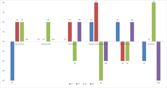
| ES Bundle | Area (%) | Recreation (%) | Biodiversity (%) | Historical (%) | Aesthetic (%) | Soil Retention (%) | Surface Water Regulation (%) | Soil Nutrition (%) |
|---|---|---|---|---|---|---|---|---|
| Soil protection (SP) | 24 | 23 | 15 | 13 | 18 | 10 | 12 | 10 |
| Forest park (FP) | 10 | 27 | 15 | 14 | 19 | 8 | 13 | 8 |
| Sightseeing entertainment (SE) | 22 | 26 | 16 | 12 | 21 | 8 | 9 | 8 |
| Ecological conservation (EN) | 44 | 25 | 15 | 14 | 17 | 10 | 10 | 10 |
Publisher’s Note: MDPI stays neutral with regard to jurisdictional claims in published maps and institutional affiliations. |
© 2021 by the authors. Licensee MDPI, Basel, Switzerland. This article is an open access article distributed under the terms and conditions of the Creative Commons Attribution (CC BY) license (http://creativecommons.org/licenses/by/4.0/).
Share and Cite
Zhao, Q.; Chen, Y.; Cuan, Y.; Zhang, H.; Li, W.; Wan, S.; Li, M. Application of Ecosystem Service Bundles and Tour Experience in Land Use Management: A Case Study of Xiaohuangshan Mountain (China). Remote Sens. 2021, 13, 242. https://0-doi-org.brum.beds.ac.uk/10.3390/rs13020242
Zhao Q, Chen Y, Cuan Y, Zhang H, Li W, Wan S, Li M. Application of Ecosystem Service Bundles and Tour Experience in Land Use Management: A Case Study of Xiaohuangshan Mountain (China). Remote Sensing. 2021; 13(2):242. https://0-doi-org.brum.beds.ac.uk/10.3390/rs13020242
Chicago/Turabian StyleZhao, Qiqi, Yanming Chen, Yuda Cuan, Han Zhang, Wei Li, Sida Wan, and Manchun Li. 2021. "Application of Ecosystem Service Bundles and Tour Experience in Land Use Management: A Case Study of Xiaohuangshan Mountain (China)" Remote Sensing 13, no. 2: 242. https://0-doi-org.brum.beds.ac.uk/10.3390/rs13020242