Communication

Sensing the Past: Perspectives on Collaborative Archaeology and Ground Penetrating Radar Techniques from Coastal California

by
Gabriel M. Sanchez
1,*,†,
Michael A. Grone
2,†,
Alec J. Apodaca
3,†,
R. Scott Byram
4,
Valentin Lopez
2 and
Roberta A. Jewett
4
1
Department of Anthropology, Michigan State University, 655 Auditorium Rd, East Lansing, MI 48824, USA
2
Amah Mutsun Land Trust, Amah Mutsun Tribal Band, P.O. Box 6915, Albany, CA 94706, USA
3
Department of Anthropology, University of California, Berkeley, 232 Kroeber Hall, Berkeley, CA 94720, USA
4
Archaeological Research Facility, University of California, Berkeley, 2251 College Ave, Berkeley, CA 94720, USA
*
Author to whom correspondence should be addressed.
These authors contributed equally to this research and share the credit as first-author.
Submission received: 10 November 2020 / Revised: 10 January 2021 / Accepted: 13 January 2021 / Published: 15 January 2021
(This article belongs to the Special Issue Remote Sensing of Archaeology)

Abstract

:
This paper summarizes over a decade of collaborative eco-archaeological research along the central coast of California involving researchers from the University of California, Berkeley, tribal citizens from the Amah Mutsun Tribal Band, and California Department of Parks and Recreation archaeologists. Our research employs remote sensing methods to document and assess cultural resources threatened by coastal erosion and geophysical methods to identify archaeological deposits, minimize impacts on sensitive cultural resources, and provide tribal and state collaborators with a suite of data to consider before proceeding with any form of invasive archaeological excavation. Our case study of recent eco-archaeological research developed to define the historical biogeography of threatened and endangered anadromous salmonids demonstrates how remote sensing technologies help identify dense archaeological deposits, remove barriers, and create bridges through equitable and inclusive research practices between archaeologists and the Amah Mutsun Tribal Band. These experiences have resulted in the incorporation of remote sensing techniques as a central approach of the Amah Mutsun Tribal Band when conducting archaeology in their traditional territories.

Graphical Abstract

1. Introduction

Over a decade ago, Kent Lightfoot [1] advocated for a rethinking of archaeological research designs and demonstrated how equitable, inclusive, and community-based participatory research practices facilitated research with the Kashaya Pomo tribe in northern California while including the perspectives of a diversity of stakeholders, including Russian citizens, local Sonoma County residents, and other local tribal nations. In his seminal paper, Lightfoot [1] argued for implementing low-impact and “surgical” excavation strategies conceptualized using a medical analogy model, suggesting that researchers fully evaluate surface, near-surface, and subsurface materials via low-impact techniques before implementing invasive subsurface excavations.
Implementing low-impact and minimally-invasive field strategies to document the structure and composition of archaeological sites (e.g., vertical and horizontal dimensions, artifact concentrations, locations of features like house floors, earth ovens, and refuse pits), involves several stages, as outlined by Lightfoot [1]. First, researchers begin with comprehensive mapping of the site(s) via topographic maps, digital elevation models, and/or terrestrial and aerial Light Detection and Ranging (LiDAR), using preexisting data and supplementing these datasets when necessary. Second, researchers establish a systematic grid system to conduct an intensive surface collection of archaeological materials with standardized sampling, recovery, and quantification strategies. These data from near-surface deposits are used to create isopleth artifact density maps for each material class encountered, thereby identifying areas where food processing and other activities may have occurred, habitation features, and areas with a high potential to yield dense and diverse subsurface archaeological deposits. Third, researchers use the data from the previous phases to place geophysical survey grids, including ground-penetrating radar, magnetometry, and electromagnetic resistivity, especially in locations where surface survey units yielded the highest densities. Lastly, integrating the findings from previous phases, collaborators work together to identify locations for subsurface excavations where potential intact features and dense midden deposits may occur while avoiding sensitive features such as human and nonhuman burials and other sacred objects. The low-impact and multistage field methodology advocated by Lightfoot [1] to record site composition and guide subsurface excavations contrast with the more common probabilistic sampling and extensive exploratory excavation strategies in archaeology. Beginning with the least intrusive field methods before proceeding to more invasive techniques, this multistage research approach allows earlier stages of research to inform subsequent stages and provides crucial flexibility for collaborative archaeological projects.
This innovative research design and development of low-impact field methods advocated by Lightfoot [1] over a decade ago have influenced a new generation of archaeologists and continue to be refined [2]. These approaches have been implemented across California and beyond to study European colonialism [3,4,5,6,7], Native Californian persistence [8,9,10], indigenous fire management strategies [11,12,13,14,15,16,17], and the stewardship of marine and estuarine fisheries by Amah Mutsun and Coast Miwok ancestors [18,19,20,21]. In all these examples, the field methods advocated by Lightfoot [1] were critical to guiding subsequent subsurface excavation strategies, along with studying and integrating the cultural heritage of Native Californian tribal communities in archaeological practice. Nonetheless, the low-impact field procedures advocated by Lightfoot [1] have not been explicitly reported and illustrated in previous studies [20,21] and is still somewhat of a novelty technique in most archaeological undertakings in California. In this paper, we attempt to remedy this dearth of data.
This paper outlines a recent community-based and collaborative archaeological research project involving the Amah Mutsun Tribal Band, researchers from the University of California, Berkeley (UC-Berkeley), Michigan State University, and California Department of Parks and Recreation (CDPR) that implements geophysical techniques and low-impact archaeological methods to investigate human-environmental and human-salmon relationships of relevance to the goals of Amah Mutsun, CDPR, other state and federal agencies, and conservation groups. Specifically, our project is directed towards the recovery of ancient anadromous salmon (Oncorhynchus sp.) remains to provide historical datasets of salmon distribution and genetic diversity. We demonstrate how advances in archaeological geophysics and their implementation by California archaeologists were a critical component in trust-building between the Amah Mutsun Tribal Band and University of California archaeologists. Based on examples from our recent field research and other case studies that span over a decade, we demonstrate that the implementation of archaeological geophysics has become a fundamental approach of the Amah Mutsun Tribal Band when conducting archaeological research in their traditional territories.

1.1. Collaborative Eco-Archaeology with the Amah Mutsun, UC-Berkeley, and California Department of Parks and Recreation

The Amah Mutsun Tribal Band are the descendants of the indigenous peoples forcefully removed from their traditional territories spanning portions of present-day San Mateo, Santa Cruz, San Benito, San Jose, and Monterey Counties and taken to Mission San Juan Bautista and Mission Santa Cruz. Since time immemorial, the Amah Mutsun Tribal Band’s ancestors have accumulated knowledge of human-environmental relationships in central California [17].
However, because of Spanish missionization (1769 to 1821), which forcibly suppressed indigenous cultural practices and eroded tribal culture, tribal knowledge was altered, and many traditions were lost. Furthering these changes were the seven missions established within the Amah Mutsun’s traditional territories between 1770–1997 and Spanish laws prohibiting indigenous burning practices [17,22]. During the Mexican Period (1821–1848), the secularization of the missions in 1834–1836 by the Mexican government resulted in indigenous people leaving the missions to work as manual laborers on the ranchos established in their traditional lands previously held by the missions and now under the control of Mexico [22,23]. With the onset of the American Period (1850–present), state and federal officials sanctioned and facilitated a coordinated genocide of California’s indigenous peoples between 1848 and 1900 [24,25,26,27,28,29].
Furthermore, as outlined by Madley [30], disease, dislocation, and starvation increased the number of deaths. Abduction, forced labor, high mortality rates on reservations, unrelenting murders, and battles and atrocious massacres by state militias and federal troops also took countless lives [30]. Therefore, throughout these three periods of colonialism, the Amah Mutsun and other indigenous people’s main concern was survival [17]. Many California Indian tribes, including the Amah Mutsun, were unable to pass on their knowledge regarding traditional resource and environmental management practices and other cultural traditions [17], which led to these practices becoming dormant in later historic times.
In recent years the Amah Mutsun have used archaeology as one approach to revitalize dormant indigenous knowledge and cultural practices along with the study of ethnographic and ethnohistorical documents, partnerships with other indigenous Californian tribes, and other groups. Using collaborative research and archaeological geophysics allowed the team to ethically carry out excavations at sensitive archaeological sites to support broader cultural revitalization efforts of the Amah Mutsun. The development of this collaborative approach, where low-impact archaeology and geophysical methods are front-and-center, is outlined below.
In 2007, archaeologists and environmental scientists from UC-Berkeley approached the Amah Mutsun Tribal Band to initiate an eco-archaeological study of indigenous fire use in central California at Quiroste Valley in Año Nuevo State Park [31]. Initial archaeological surveys in the Quiroste Valley during the 1980s resulted in the recording of over a dozen ancient and historic sites. During 2004–2006, Cabrillo Community College led test excavations and obtained radiocarbon dating assays that suggested a contact era site within the valley, potentially Casa Grande or Metenne, a Quiroste village documented by the Portola overland expedition in 1769, comprised of multiple house structures and a large ceremonial dance house to hold more than a hundred people [31]. A collaborative project involving the Amah Mutsun Tribal Band, CDPR, and UC-Berkeley was initially facilitated by Dr. Chuck Striplen, an Amah Mutsun tribal member and a former Ph.D. student in the Department of Environmental Science and Policy Management pursuing dissertation research on fire ecology and the historical ecology of California’s forests.
A collaborative enterprise was developed to study cultural burning and ancient indigenous landscape management practices in Quiroste Valley [11,17]. While initially hesitant of collaborating with archaeologists, due to a legacy of non-collaboration and disturbance of sacred indigenous sites, the Amah Mutsun approved the archaeological research. Their decision to jointly engage in archaeological research was based on an agreement with UC-Berkeley archaeologists, which ensured they would: (a) minimize adverse impacts to any sites investigated; (b) avoid all sensitive cultural materials, such as human remains and other sacred objects; and (c) employ low-impact field methodologies guided by geophysics to identify discrete deposits with potential to contain high-density cultural materials and artifacts related to indigenous foodways (e.g., fish bones, carbonized plant tissues, invertebrate remains, stone tools, and other important features) and other activities of particular interest to the tribe. Therefore, advances in archaeological geophysics and their incorporation in low-impact field strategies were critical in this research and building trust between the Amah Mutsun and academic researchers. The collaborative program emphasized the inclusion of tribal members in all phases of research and recognized the final decision-making authority of the Amah Mutsun Tribal Band [17].
By 2009, CDPR and Amah Mutsun Tribal Band co-created a 220-acre (80.9 hectares or 809,371 m2) Quiroste Valley Cultural Preserve to protect cultural resources, restore native vegetation, and re-implement and experiment with traditional resource stewardship practices, such as cultural burning. In 2012, the Amah Mutsun Land Trust was created—a nonprofit organization directed toward conservation, restoration, stewardship, education, and research on aboriginal lands. The organization partners with other conservancy groups to facilitate the Amah Mutsun Native Stewardship Corps, which employs young adult tribal members in resource conservation and research opportunities. Therefore, after many years of struggle to regain access to their traditional territories and practices, the Amah Mutsun are now working to restore the indigenous knowledge suppressed during colonization [17]. Given that they do not currently possess landholdings within their tribal territory, the stewardship of their traditional lands has been facilitated by creating partnerships with public and private landowners.

1.2. Previous Geophysical Archaeological Research in the Study Area

In our study area, limited geophysical surveys have been conducted by archaeologists, and those archaeological projects that include geophysics stem from the collaborative archaeological research between the Amah Mutsun Tribal Band and UC-Berkeley researchers. As mentioned above, the results of these geophysical surveys remain mostly unpublished and unreported. However, dissertation research by Cuthrell [11] applies and explicitly reports the results of geophysical surveys in the Quiroste Valley at site CA-SMA-113, known as Metenne located within the Quiroste Valley Cultural Preserve. In researching anthropogenic fire regimes and the potential that indigenous peoples used fire as a tool to manage the landscape to increase the diversity of plant and animal communities, Cuthrell [11] employed the multistage and low-impact archaeological methodologies developed by Lightfoot [1].
The research project relied on geophysics such as magnetometry, resistivity, and ground-penetrating radar to explore subsurface deposits to locate potential features with high integrity for targeted excavation and to avoid disturbing sensitive cultural materials such as human burials. The geophysical survey of CA-SMA-113 included magnetometer surveys comprised of 24 survey grids with a total area of 4494 m2; the magnetometer survey was conducted using a Geometrics G-858 gradiometer. A smaller-scale resistivity survey was conducted over areas previously investigated by magnetometry survey where potential magnetic anomalies were detected. Resistivity survey employed an Advanced Geosciences MiniSting resistivity meter with a Swift multi-electrode control box and switch box connected to a 28-lead electrode cable. A ground-penetrating radar survey of the site occurred. A single 12 m × 60 m grid was surveyed once in 2007, and a 17 m × 27 m portion of the 2007 grid was resurveyed in 2012 following the termination of excavations at the site. However, the results of both surveys were inconclusive.
Consequently, excavations were guided by the results of the magnetometry and resistivity surveys. Cuthrell [11] excavated 22 1 m × 1 m excavation units. Four subsurface features were excavated, two archaeological features (i.e., pit and hearth features with ash and fire-affected rock), and two modern features—interpreted as modern fire pits and back dirt accumulations from previous excavations at the site. Excavated features were identified during the magnetometer survey as high ambient magnetic anomalies. The case study reported by Cuthrell [1] represents the only previously reported application of archaeological geophysics in the immediate study area. While additional geophysical research has been conducted by the Amah Mutsun and the collaborative research team at a series of sites in Santa Cruz County, CA-SCR-7, CA-SCR-10, CA-SCR-14, and CA-SCR-15, these data remain unpublished and unreported.

1.3. Current Project

In 2018, at the request of Valentin Lopez, Chairman of Amah Mutsun Tribal Band, Sanchez and colleagues initiated an eco-archaeological and museum-based research project in San Mateo, Santa Cruz, and Monterey Counties to provide information on the historical ecology of anadromous salmon (Oncorhynchus sp.) and other ecological constituents of relevance to the tribe [12,13,14,16,17]. The research project aims to inform the conservation and management of native salmon species in San Mateo, Santa Cruz, and Monterey Counties, given recent debates regarding the historical biogeography of native anadromous salmon and the potential extirpation or extinction of these cultural keystone species [20,21]. California is home to 32 distinct salmonid fishes, either endemic to California or at the southern extent of their ranges [32]. Research suggests California will lose more than half of its native salmonids in the next half-century [32]. Restoration of these iconic organisms requires protection and rehabilitation of coastal streams and habitat and the protection of salmonid genetic diversity.
Despite pressing concerns regarding anadromous salmonids’ extirpation, their historical biogeography is still highly debated [33,34,35,36]. Some researchers have argued that the endangered Coho salmon (Oncorhynchus kisutch) is not native south of the San Francisco Bay [36], while others suggest Coho are native as far south as Santa Cruz County and possibly further [33,34]. Given that species are most susceptible to extinction and extirpation at the edge of their ranges [37], clarifying the biogeographical extent of anadromous salmonids along the central California coast is highly relevant. While their native status is still under debate, Coho salmon and steelhead (O. mykiss irideus) south of San Francisco are listed as endangered under the Federal Endangered Species Act and the California Endangered Species Act [32,36]. Knowledge of the historical biogeography and extent of Coho salmon and steelhead is necessary to guide restoration planning and future management decision-making. To facilitate our salmonid research, we partnered with Peninsula Open Space Trust and CDPR to identify archaeological sites and archaeological museum collections adjacent to known or probable salmonid streams that may contain ancient and historic salmonid remains and yield molecular data to determine species designation and genetic diversity.
In the summer of 2019, we initiated a field project at CA-SMA-184, known as the Butano Mound, preserved and managed by Peninsula Open Space Trust in proximity to Pescadero Marsh, a major watershed in the region (Figure 1). Butano Mound was selected as an initial project area for three reasons. First, the site is located near Butano Creek, tributary steam to Pescadero Creek, which may have historically supported Coho salmon and steelhead [38]. Second, in the summer of 2019, the Butano Creek Reconnection Project was initiated and designed to remove sediments in Butano Creek and Pescadero Marsh to support salmon conservation and habitat rehabilitation efforts [39]. Therefore, our historical ecological research of the Butano Mound had the potential to provide timely data that could inform current and future salmon conservation in the immediate study area. Third, a previous archaeological survey of the Butano Mound suggested the site was a village and thus offered the opportunity to recover highly dense and diverse cultural materials that might include salmonid remains from food-related activities given its proximity to Butano Creek and Pescadero Marsh [40].

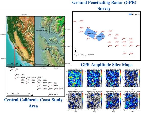
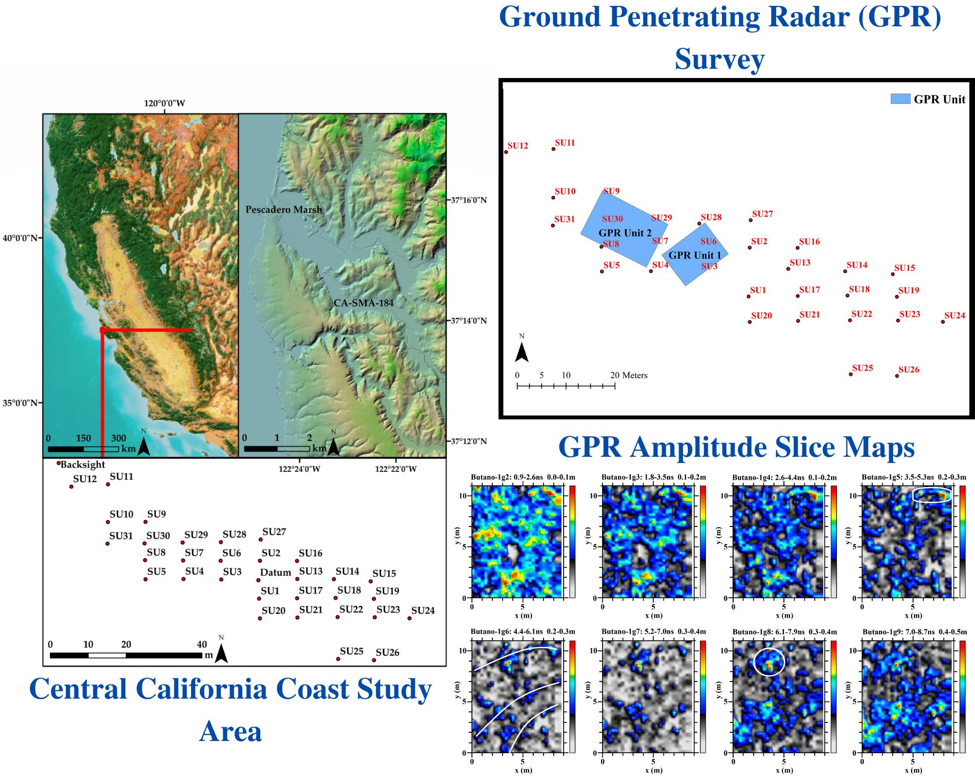
2. Methods and Materials
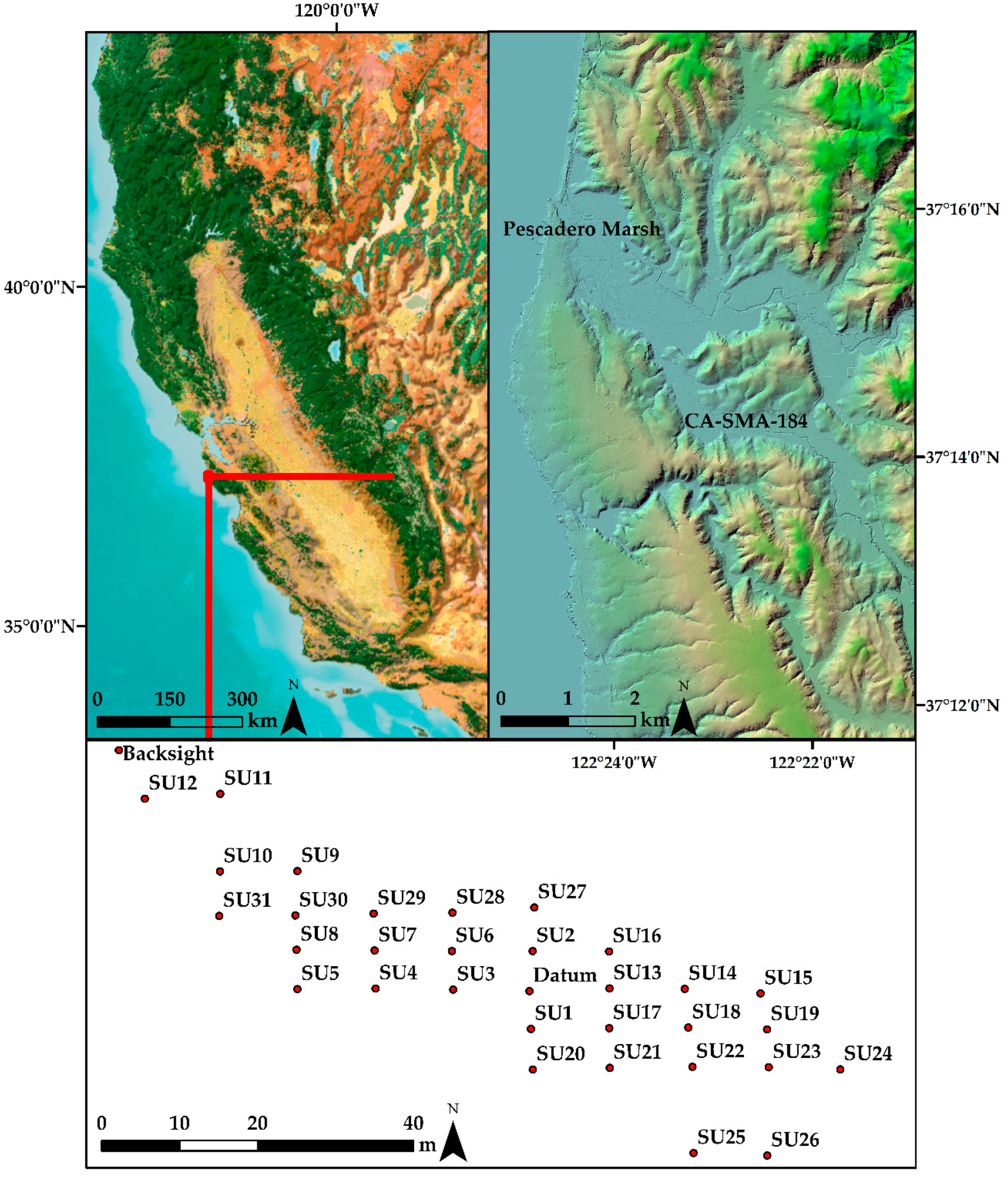
We initiated our field research at the Butano Mound by establishing a datum and backsight using a Trimble GeoXH600 receiver with a Trimble Tornado GNSS antenna capable of providing sub-centimeter accuracy (Figure 1). The datum was established near the mound’s central apex based on digital elevation models referenced during the project’s background research phase. Next, we used a Sokia SET 530r3 Total Station to establish a surface survey grid comprised of 31 units. Surface survey units were spaced at 5 m intervals along the north/south axis and 10 m intervals along the east/west axis to establish site boundaries. Three crews, each comprised of two field members, surveyed each surface survey unit with the following established low-impact and catch and release surface survey methods, outlined below [1,2].
First, we created a 40 cm radius circle applying the “dog-leash” method [41] from each unit datum to establish the unit’s boundaries. Next, field crews removed surface vegetation within their unit to expose cultural materials. Then, crews collected three liters of soil sampling equally from all sections of the unit. The three liters were screened using 1/8” mesh soil sieves, and all cultural materials were sorted, counted (all material classes except shellfish and fire-cracked rock), weighed, and recorded in situ. After each unit was analyzed, cultural materials were returned to their respective units. These data were used to create density maps to reveal cultural material concentrations (i.e., shellfish remains, faunal remains, lithics, and fire-cracked rock) to identify locations with dense and diverse shell midden deposits (Figure 2).
To analyze surface material densities, we applied the kernel density tool from the spatial analyst toolbox and density toolset in ArcMap 10.7 to create density maps [42]. The kernel density estimations calculated the respective materials classes (i.e., faunal remain counts, and total gram weight for lithics including Monterey chert, Franciscan chert, and obsidian, fire-cracked rock, and total shellfish weight) per square meter and were created using the GEODESIC method [42]. While we recognize that cultural materials derived from 80 cm diameter units are being represented in meters in ArcMap, this was the closet concordance of our methods in ArcGIS. We advocate for future use of 1-m diameter surface survey units to mitigate these limitations in future application of the methodology outlined in this study. The selected material classes are used as proxies for various human activities and practices of interest, such as food processing and preparation (shellfish, fauna, and fire-cracked rock) and stone tool maintenance and production (lithics, groundstone, and flaked stone debitage). The results of the surface surveys and density maps provided insight regarding site structure and spatial patterning of archaeological remains across the Butano Mound that was incorporated into our decision-making concerning subsequent fieldwork.
Based on the surface survey results and density estimations, we established two ground-penetrating radar grids to investigate locations that appeared to represent dense shell midden deposits (Figure 3). Ground-penetrating radar (GRP) grid one measured 11 m × 8 m, and grid two measured 15 m × 10 m, both oriented along the mound’s long axis. Before initiating ground-penetrating radar surveys, we placed three augers—10 cm diameter with 20 cm levels—to establish the archaeological deposits’ depth to assist in the ground-penetrating radar configuration and postprocessing the results as shell midden depths were known rather than estimated. The ground-penetrating radar grids were surveyed with the following methods and procedures. Each unit was surveyed with three ground-penetrating radar transects per meter. All transects were initiated from the units southwest corner with transects running north (odd numbers) and south (even numbers). The transect interval was approximately 33 cm, with transect distance measured by a calibrated survey wheel. We used a GSSI SIR4000 with a 400 MHz antennae. Ground-penetrating radar grids were post-processed in the GPR Slice Program (Version 7.MT), and individual transect profiles “radargrams” were processed in GPR Viewer (Version Beta 1.8.5) and included the use of a background filter to remove ambient regional interference. We recorded GNSS data for most transect files, including exploratory transects outside of the formal grids.
Based on the combination of surface collection survey and ground-penetrating radar results, we selected three excavation units for further study. Each excavation unit measured 1 × 1 m with cultural materials screened over 3.175 mm mesh sieves (Figure 3). Excavations were conducted in 10 cm arbitrary levels. All archaeological materials were collected. However, for logistical purposes, only the relative presence of unmodified shellfish remains and fire-cracked rocks were noted but were not collected since there was an overwhelming amount recovered in all the samples. In addition, we collected ca. 10–20 L bulk sediment samples from each arbitrary level for fine-grained recovery of materials such as small, non-dietary gastropods, fish vertebrae, and macrobotanical remains via water flotation.

3. Results

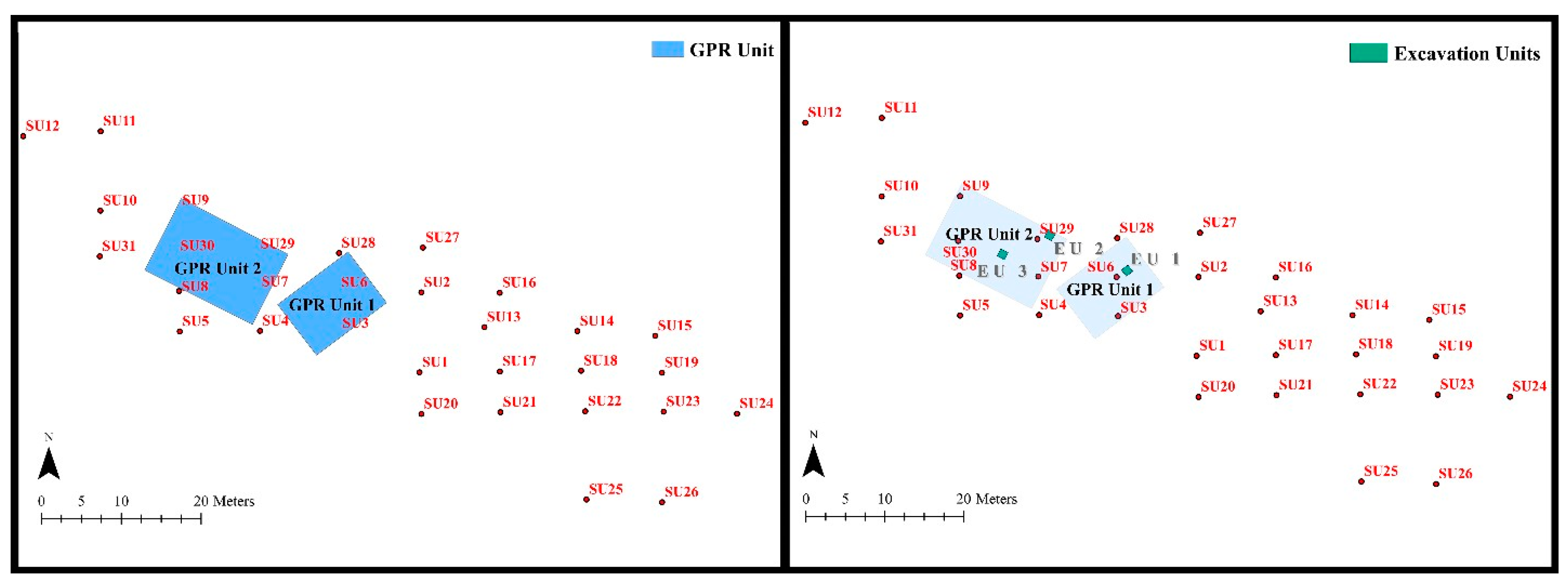
3.1. Surface Survey Units

Of the 31 surface survey units (SU) we sampled, analyzed, and quantified at Butano Mound, only the western and northwest units produced dense and diverse cultural materials, with the eastern deposits mostly devoid of cultural materials other than highly fragmented shellfish remains (Figure 2). Our density analysis began by calculating the shellfish surface remains by gram weight to locate potential dense shell midden deposits. We recognize limitations in representing our materials classes (e.g., fire-cracked rock, shellfish, and lithics) by weight rather than count. However, as the surface survey methodology is designed to locate potentially dense midden deposits expediently and the additional time and labor needed to count each material class, especially highly fragmented shellfish remains individually, we use weight as a means to accomplish the goal of locating dense and diverse deposits. Our findings and field observations highlight dense shellfish concentrations in the vicinity of SU 28 and west and south of SU 28. The eastern portion of the site had much fewer shellfish remains. The majority of shellfish remains in the eastern portion of the site were highly fragmented and likely relocated to that portion of the site by historical disturbances, such as field plowing. The faunal, fire-cracked rock, and lithic data corroborated these trends, revealing high densities of materials in the site’s western portion. Therefore, across all material classes, the densest cultural materials were consistently found in the site’s western portion. Figure 2 highlights these trends by representing shellfish remains faunal remains, fire-cracked rock (FCR), and lithic densities. Densities were the highest at SU 28 and SU 6 across all materials, but high densities were also present near SU 9, 30, 8, 5, 4, 29, and 31.
Given the high density and diversity of cultural materials at the western portion of the site and the likelihood that cultural material on the site’s eastern portion resulted from historical disturbances rather than representing discrete cultural deposits, we established two ground-penetrating radar grids where cultural materials appeared the densest. As previously mentioned, ground-penetrating radar grid one measured 11 m × 8 m, and grid two measured 15 m × 10 m. Grid one captured data near SU units 28, 6, and 3, while grid two sampled SU units 9, 29, 30, 7, and 8, representing ~25% (eight units out of 31 units) of all surveyed surface units.

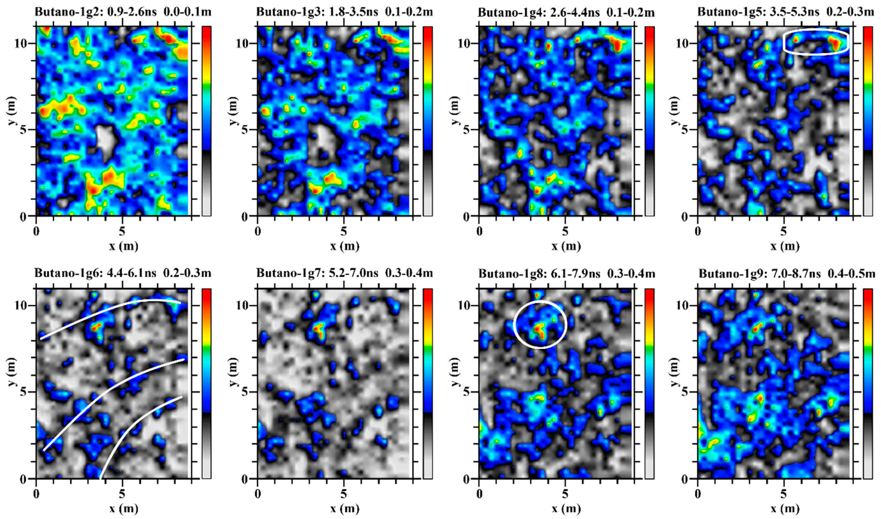
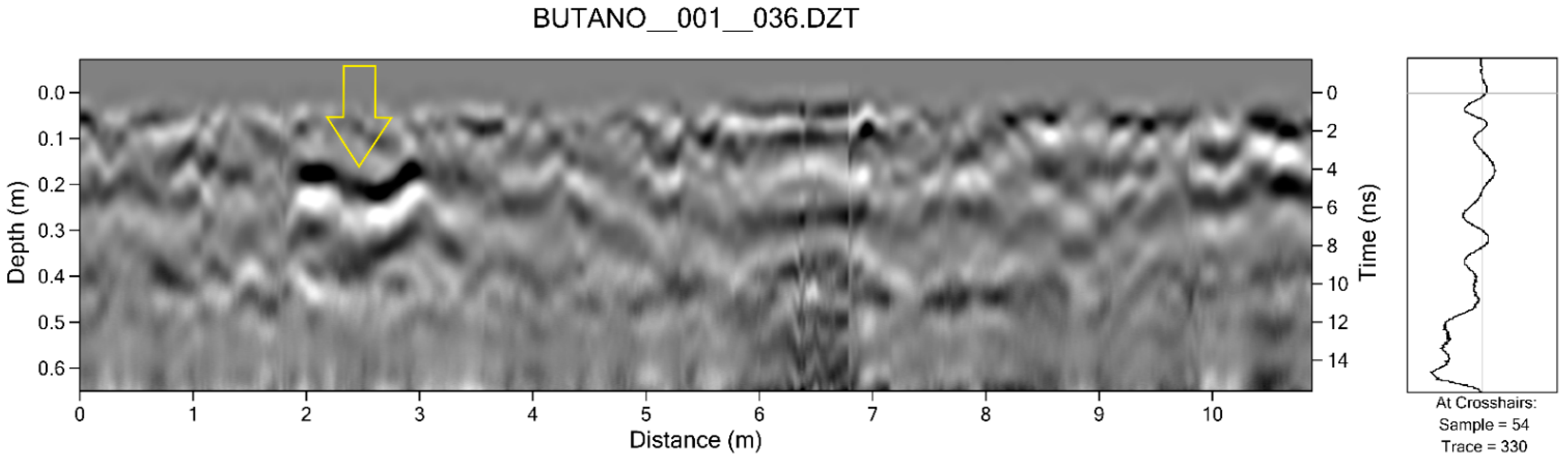
3.2. Ground-Penetrating Radar

3.2.1. Grid 1

The ground-penetrating radar survey of grid 1 resulted in 25 transect files (files 25–50), which begin in the southwest corner (0N/0E); therefore, transects represent the Y-axis (Figure 3). Our survey identified curvilinear striations traced with white lines in slice six—slices two to nine are shown (Figure 4). These striations may result from plowing of the mound historically and represent plow scars or stratigraphic incline intersections. Apart from the curvilinear striations, two potential feature areas were identified in the northern half of the grid—see Figure 4, slices five and eight. These features were highlighted by higher amplitudes noted in most amplitude slice maps and are interpreted as probable features or dense midden deposits that differ from the surrounding sediments—see radargram profile in Figure 5 for an example of the anomaly in slice 8. After communicating these results with all collaborators, we selected the potential feature in slice eight and the anomaly identified in Figure 5, which was located near SU 28 and SU 6 in a portion of the site with high densities of cultural materials and because the area had higher amplitudes in the majority of amplitude slice maps (Figure 2 and Figure 3).

3.2.2. Grid 2

The ground-penetrating radar survey of grid 2 resulted in 46 transect files (53–98), which begin in the southwest corner (0N/0E); therefore, transects represent the Y-axis (Figure 3). We identified two locations of interest for testing based on the amplitude slice maps (Figure 6). The first is a potential circular feature identified in slice five. The potential circular feature was also noted during the surface survey as a possible area of interest for further subsurface excavations, given the presence of a circular feature of rounded cobbles, which may represent the hearth of an earth oven feature. The second possible circular feature (shown in slice seven) was selected because it does not appear to be part of a curvilinear configuration that may represent rodent burrowing and may represent an intact feature or dense shell midden deposits.

3.3. Excavation Units

We decided to place three excavation units based on the surface survey results and ground-penetrating radar data. One 1 m × 1 m excavation unit (EU) was placed within ground-penetrating radar grid 1 (EU1) and two 1 m × 1 m excavation units within grid 2 (EU2 and EU3). As previously mentioned, we identified high densities of artifactual materials in the site’s western area during the catch and release surface survey. The GPR data patterns appeared to have pointed to locations of higher density cultural material (such as shell, which is often highly reflective in concentration) though distinctive features such as house floors were not identified through excavation. The ground-penetrating radar survey undertaken in this area identified potential features represented by high amplitude areas and hyperbolae in amplitude slice maps and individual transect files. Therefore, the units were placed in high amplitude areas that may represent features.

3.3.1. Unit 1

Excavation unit 1 (EU1) was placed in grid 1 in a location we believed may contain intact deposits, although curvilinear striations identified in amplitude slice maps suggested the potential that the site had been previously plowed, which is not uncommon for shell middens along this section of the coast [11]. The excavation and ground-truthing of the unit produced various materials, including faunal remains, lithics, and fire-cracked rock. Two levels were excavated in the unit, which terminated at roughly 23–30 cm below datum (bd) as sterile sediments occur below these depths. Twenty liters of sediment were sampled from each level. The unit included dense shell midden deposits that included evidence of rodent bioturbation and historic plowing. However, no intact features, such as the remnant hearths of earth ovens, were encountered. Evidence for plowing included a water-worn cobble with multiple plow scars. Excavation of the unit resulted in the recovery of complete salmonid vertebrae. We were, therefore, optimistic that further excavations could result in a larger salmon sample size.

3.3.2. Unit 2

Excavation unit 2 (EU2) was placed in grid 2, where based on the ground-penetrating radar and surface survey data, we believed there might be a circular feature. Two levels were excavated in EU2 with bulk sediment samples taken. The unit terminated at ~25 cm bd after encountering sterile sediments at this depth. Consistent with our findings from EU1, EU 2 included dense shell midden deposits that exhibited evidence of rodent bioturbation on the southern sections of the unit and plow zone type midden deposits.
The first level 0–10 cm bd produced multiple Split Punched (Type D-1) and Wide Sequins (Type M1d) Olivella (Olivella biplicata) beads [43]. Wide Sequins and Split Punched Olivella beads are typical of central California Olivella beads reported exclusively in Middle/Late Period Transition (cal AD 1010–1210) contexts. Elsewhere Wide Sequins have been recovered in contexts that suggest they were sewn side-by-side on fabric [43]. Like the Wide Sequins, the Split Punched beads are also temporally diagnostic of the Middle/Late Period Transition [43]. The Butano Mound chronology will be further investigated by forthcoming high-resolution accelerator mass spectrometry (AMS) radiocarbon dating of recovered archaeobotanical and faunal remains.

3.3.3. Unit 3

Excavation unit 3 (EU3) was placed in grid 2 to test an area that may contain a circular feature based on the ground-penetrating radar data. EU3 terminated at about 20 cm bd as sterile sediments occur below these depths. Upon ground-truthing the shell midden deposits, we encountered dense cultural deposits that included evidence of rodent bioturbation and further evidence that the mound had been plowed historically. In the southeast corner of the unit, we found that midden deposits were present below the sterile clay that underlies the site, likely due to bioturbation.
To test our assumptions, we placed augers within EU1 and EU2 below the sterile clay to a depth of about 60 cm and found multiple deeply buried rodent burrows with midden in them. Despite the historical and natural disturbances, our field efforts resulted in the recovery of faunal and paleoethnobotanical data, which appear to be well preserved based on the recovery of visually observable macro-remains of hazelnut (Corylus cornuta var. californica) and wood charcoal from one-eighth inch screening and preliminary analyses of flotation samples.

4. Discussion

Our historical ecological research project was designed to recover ancient and historical evidence of salmon remains and other eco-archaeological datasets from archaeological sites and museum collections from Santa Cruz, San Mateo, and Monterey Counties to inform ongoing debates regarding the native status of threatened and endangered salmon species. The collaborative research project applies low-impact archaeological field methods that rely critically on the incorporation of archaeological geophysics and other surface and near-surface investigations to guide excavation strategies. Our recent research at the Butano Mound highlights how the low-impact field methods advocated by Lightfoot [1] is a fundamental process of collaborative archaeological research programs and directly complement Amah Mutsun approaches to archaeology.
At this time, the field methodologies advocated by Lightfoot [1] and its application in California have remained site-specific and conducted at a small-scale rather than at the landscape level [2,3,4,9,11,21]. However, we recognize that landscape-level and wide-coverage remote sensing, integrating various remote sensing techniques that include targeted ground-truthing and excavation of identified features, offer numerous advantages [44,45,46]. We hope the methods and techniques advocated for in this study and broader landscape-level remote sensing approaches are adopted by researchers in California, tribal organizations, and beyond.
Our findings from recent fieldwork at the Butano Mound demonstrate how the application of low-impact field excavation methodologies are a critical component of conducting indigenous archaeology in our collaborative work with the Amah Mutsun Tribal Band that aims to preserve and revitalize their cultural heritage. Through our study and analysis of digital elevation models, surface survey through the application of catch and release methods [1,2,41], geophysical survey, and small-scale excavations, we are recovering eco-archaeological data that are relevant to our community partners and local conservation issues. Our current research and collaboration with the Amah Mutsun is an outgrowth of a broader eco-archaeological research program initiated in 2007 (see above). The ability to use and apply archaeological geophysics was critical to developing a trusting, collaborative relationship between the Amah Mutsun and UC-Berkeley archaeologists. It provided a method to study ancestral sites that minimized impacts on these spaces and increased the likelihood that sensitive areas and materials would not be disturbed.
Based on the initial geophysical studies conducted in collaboration with the Amah Mutsun by Cuthrell [1], archaeological geophysics is now a central approach of the Amah Mutsun when conducting archaeology in their traditional territories. Therefore, geophysical techniques are a prerequisite to archaeological field research on ancestral sites and landscapes and can help other contemporary tribes who remain skeptical of archaeologists reach an ethical approach to conduct an excavation. While the Amah Mutsun do not currently own geophysical survey equipment, they can gather the data needed to make informed decisions regarding subsurface excavations before they occur through their collaboration with academic researchers at various institutions. The collaborative experiences outlined in this paper have demonstrated to the Amah Mutsun the unique advantage that ground-penetrating radar studies provide and is thought of as a “non-negotiable” method to be integrated with any invasive form of archaeological research of ancestral sites. However, the development of an Amah Mutsun Land Trust Cultural Resource Management Program is underway, where qualified tribal members lead and carry out archaeological studies in their traditional territories.
In the current case study, all fieldwork was conducted by researchers at UC-Berkeley and Michigan State University at the request of the Amah Mutsun Tribal Band. However, research findings from every phase of research (background research, the establishment of survey grid, results of surface survey units, placement and results of ground-penetrating radar, and placement and findings from excavations) were shared with tribal chairman Valentin Lopez and other community members, who were conducting cultural programming and research in the immediate area. We are currently finding ways to integrate tribal members in the Amah Mutsun Land Trust Cultural Resource Management Program in more advanced stages of GPR surveying and data processing. However, it is important to note that Amah Mutsun tribal members have participated in all phases of archaeological research, including multiple UC-Berkeley led field schools to assist in community capacity building by having tribal members conduct a pedestrian survey, establish survey grids, running geophysical equipment, conducting excavations, processing soil samples via water flotation, and laboratory research since the initiation of the collaborative and community-based research project in 2007 [11]. Nonetheless, during the fieldwork reported in this case study, scheduling conflicts made it difficult for tribal stewards to participate due to other projects that were occurring in the study area that included the stewards.
Although the materials of our 2019 field research are still being processed, our preliminary findings suggest that the Butano Mound likely represents an inland village location, based on the diversity of archaeological materials recovered and representing the occurrence of a wide range of cultural activities. Additionally, temporally diagnostic Wide Sequins and Split Punched Olivella beads suggest occupation of the site around cal AD 1010–1210 or during the Middle/late Period transition in central California. These findings are especially relevant as the Butano Mound is contemporaneous with the Quiroste Valley village site CA-SMA-113, which has provided strong evidence of anthropogenic landscape management via small scale fires to expand coastal grassland prairies [11,12,15,16]. Therefore, our current study can broaden discussions regarding anthropogenic landscape management by the Quiroste tribelet outside of the Quiroste Valley [31].
The salmonid remains recovered from the Butano Mound, and a select sample from museum collections are currently awaiting molecular analyses. Unfortunately, our laboratory and molecular analyses and additional field research at CA-SMA-184 and other adjacent sites are currently delayed due to the COVID-19 pandemic and the wildfires that have recently ravaged California and our study area.

5. Conclusions

Our collaborative eco-archaeological research at CA-SMA-184, otherwise known as the Butano Mound, was designed to recover ancient salmon remains that could inform the conservation and management of modern salmon species and applied low-impact archaeological field methods and geophysics to guide all phases of archaeological fieldwork. This collaborative, community-based archaeological research was initiated at the request of the Amah Mutsun Tribal Band, as they are highly concerned about the present state of salmonids in their traditional territories and elsewhere along the coast.
In this paper, we have summarized how developments in archaeological field methodologies through the advancement of low-impact archaeological field strategies and archaeological geophysics have facilitated research between the Amah Mutsun, UC-Berkeley, and recently Michigan State University archaeologists. We further suggest that these methodological developments in field research are a critical component of trust-building and provided critical data for all collaborative partners so that informed decisions could guide all phases of archaeological research. These approaches are vital to preserving and revitalizing the region’s cultural heritage and minimizing unnecessary impacts on the cultural resources of the Amah Mutsun.
While our excavations at the Butano Mound encountered shell midden deposits previously disturbed by rodent bioturbation and historical plowing, our field research resulted in the recovery of dense and diverse cultural materials. In addition, stratigraphic evidence from ground-penetrating radar survey and ground-truthing, the shallow nature of the deposits, and diagnostic Olivella beads suggest a short-term occupation of the Butano Mound. The archaeological data we recovered are currently being processed and analyzed at Michigan State University and UC-Berkeley and will contribute valuable historical baseline data regarding local vertebrate and invertebrate fauna, and paleoethnobotanical data that is highly relevant to the Amah Mutsun, the scientific community, state and federal agencies, and conservation groups.

Author Contributions

G.M.S.: Conceptualization, Data curation, Formal analysis, Investigation, Methodology, Writing—Original draft preparation, Writing—Review and editing, Visualization; M.A.G.: Investigation, Writing—Original draft preparation, Writing—Review and editing; A.J.A.: Investigation, Writing—Original draft preparation, Writing—Review and editing; R.S.B.: Data curation, Formal analysis, Investigation, Methodology, Software, Validation, Visualization; V.L.: Conceptualization, Investigation, Writing—Review and editing; R.A.J.: Investigation, Writing—Review and editing. All authors have read and agreed to the published version of the manuscript.

Funding

This research received no external funding.

Institutional Review Board Statement

Not applicable.

Informed Consent Statement

Not applicable.

Data Availability Statement

The data presented in this study are available on request from the corresponding author.

Acknowledgments

Funding for the project has been generously provided by various donors who supported this project via GoFundMe, which made the field research possible. We would like to thank Peninsula Open Space Trust, especially Laura O’Leary, for providing permission and permits to conduct our research at the Butano Mound. We are also indebted to Mark Hylkema, CDPR, for his assistance in accessing the Butano Mound and providing permits to conduct our work. We want to thank Adrianna Allen of Photon Illustration for assisting with the production of Figure 2, Figure 3, Figure 4 and Figure 5. We would like to recognize Kathryn Field, Ariadna Gonzalez, and Katharine Nusbaum for their field research assistance. We thank the editors of this special issue Carl Philipp Lipo and Timothy S de Smet, for their invitation to contribute. Our manuscript benefitted from anonymous reviewers’ contributions and the editors of Remote Sensing, especially Darcy Zhang.

Conflicts of Interest

The authors declare no conflict of interest. The funders had no role in the design of this study; in the collection, analyses, or interpretation of data; in the writing of the manuscript, or in the decision to publish the results.

References

  1. Lightfoot, K.G. Collaborative Research Programs: Implications for the Practice of North American Archaeology. In Collaborating at the Trowel’s Edge: Teaching and Learning in Indigenous Archaeology; Silliman, S.W., Ed.; The University of Arizona Press: Tucson, AZ, USA, 2008; pp. 211–227. [Google Scholar]
  2. Gonzalez, S.L. Indigenous Values and Methods in Archaeological Practice: Low-Impact Archaeology Through the Kashaya Pomo Interpretive Trail Project. Am. Antiq. 2016, 81, 533–549. [Google Scholar] [CrossRef]
  3. Byram, R.S.; Lightfoot, K.G.; Cuthrell, R.Q.; Nelson, P.; Sunseri, J.; Jewett, R.A.; Parkman, E.B.; Tripcevich, N. Geophysical Investigation of Mission San Francisco Solano, Sonoma, California. Hist Arch. 2018, 52, 242–263. [Google Scholar] [CrossRef] [Green Version]
  4. Lightfoot, K.G.; Gonzalez, S.L. Metini Village: An Archaeological Study of Sustained Colonialism in Northern California; (Contributions of the University of California Archaeological Facility Archaeological Research Facility); Archaeological Facility Archaeological Research Facility: Berkeley, CA, USA, 2018. [Google Scholar]
  5. Lightfoot, K.G.; Simmons, W.S. Culture contact in protohistoric California: Social contexts of native and European encounters. J. Calif. Great Basin Anthropol. 1998, 20, 138–170. [Google Scholar]
  6. Lightfoot, K.G.; Wake, T.A.; Schiff, A.M. The Archaeology and Ethnohistory of Fort Ross. Archaeological Research Facility; (Contributions of the University of California Archaeological Research Facility); University of California at Berkeley: Berkeley, CA, USA, 1991. [Google Scholar]
  7. Lightfoot, K.G.; Martinez, A.; Schiff, A.M. Daily practice and material culture in pluralistic social settings: An archaeological study of culture change and persistence from Fort Ross, California. Am. Antiq. 1998, 199–222. [Google Scholar] [CrossRef]
  8. Gonzalez, S.L.; Modzelewski, D.; Panich, L.M.; Schneider, T.D. Archaeology for the seventh generation. Am. Indian Q. 2006, 30, 388–415. [Google Scholar] [CrossRef]
  9. Schneider, T.D. Placing Refuge: Shell Mounds and the Archaeology of Colonial Encounters in the San Francisco Bay Area, California. Ph.D. Thesis, University of California, Berkeley, CA, USA, 2010. [Google Scholar]
  10. Schneider, T.D.; Panich, L.M. Landscapes of Refuge and Resiliency: Native Californian Persistence at Tomales Bay, California, 1770s–1870s. Ethnohistory 2019, 66, 21–47. [Google Scholar] [CrossRef]
  11. Cuthrell, R.Q. An Eco-Archaeological Study of Late Holocene Indigenous Foodways and Landscape Management Practices at Quiroste Valley Cultural Preserve, San Mateo County, California. Ph.D. Thesis, Department of Anthropology, University of California, Berkeley, CA, USA, 2013. [Google Scholar]
  12. Cuthrell, R.Q. Archaeobotanical evidence for indigenous burning practices and foodways at CA-SMA-113. Calif. Archaeol. 2013, 5, 265–290. [Google Scholar] [CrossRef]
  13. Cuthrell, R.Q.; Striplen, C.; Hylkema, M.G.; Lightfoot, K.G.; Jones, T.L.; Perry, J.E. A land of fire: Anthropogenic burning on the central coast of California. Contemp. Issues Calif. Archaeol. 2012, 153–172. [Google Scholar]
  14. Lightfoot, K.G.; Cuthrell, R.Q.; Striplen, C.J.; Hylkema, M.G. Rethinking the study of landscape management practices among hunter-gatherers in North America. Am. Antiq. 2013, 78, 285–301. [Google Scholar] [CrossRef]
  15. Lightfoot, K.G.; Cuthrell, R.Q.; Boone, C.M.; Byrne, R.; Chavez, A.S.; Collins, L.; Cowart, A.; Evett, R.R.; Fine, P.V.A.; Gifford-Gonzalez, D.; et al. Anthropogenic Burning on the Central California Coast in Late Holocene and Early Historical Times: Findings, Implications, and Future Directions. Calif. Archaeol. 2013, 5, 371–390. [Google Scholar] [CrossRef]
  16. Lightfoot, K.G.; Lopez, V. The Study of Indigenous Management Practices in California: An Introduction. Calif. Archaeol. 2013, 5, 209–219. [Google Scholar] [CrossRef]
  17. Lopez, V. The Amah Mutsun Tribal Band: Reflections on Collaborative Archaeology. Calif. Archaeol. 2013, 5, 221–223. [Google Scholar] [CrossRef]
  18. Grone, M.A. Of Molluscs and Middens: Historical Ecology of Indigenous Shoreline Stewardship along the Central Coast of California. Ph.D. Thesis, University of California, Berkeley, CA, USA, 2020. [Google Scholar]
  19. Sanchez, G.M. The Historical Ecology and Ancient Fisheries of the Central California Coast: Insights from Point Reyes National Seashore and the Santa Cruz Coast. Ph.D. Thesis, University of California, Berkeley, CA, USA, 2019. [Google Scholar]
  20. Sanchez, G.M. Indigenous stewardship of marine and estuarine fisheries? Reconstructing the ancient size of Pacific herring through linear regression models. J. Archaeol. Sci. Rep. 2020, 29, 102061. [Google Scholar] [CrossRef]
  21. Sanchez, G.M.; Gobalet, K.W.; Jewett, R.; Cuthrell, R.Q.; Grone, M.; Engel, P.M.; Lightfoot, K.G. The historical ecology of central California coast fishing: Perspectives from Point Reyes National Seashore. J. Archaeol. Sci. 2018, 100, 1–15. [Google Scholar] [CrossRef]
  22. Levy, R. Costanoan. In Handbook of North American Indians; Heizer, R.F., Ed.; Smithsonian Institution: Washington, DC, USA, 1978; pp. 485–495. [Google Scholar]
  23. Lightfoot, K.G. Indians, Missionaries, and Merchants: The Legacy of Colonial Encounters on the California Frontiers; University of California Press: Berkeley, CA, USA, 2005; p. 338. [Google Scholar]
  24. Cook, S.F. The Conflict between the California Indian and White Civilization III: The American Invasion 1848–1870; University of California Press: Berkeley, CA, USA, 1943; p. 543. [Google Scholar]
  25. Heizer, R.F. They Were Only Diggers: A Collection of Articles from California Newspapers, 1851–1866, on Indian and White Relations; (Ballena Press Publications in Archaeology, Ethnology, and History); Ballena Press: Ramona, CA, USA, 1974; p. 126. [Google Scholar]
  26. Jacknis, I. Introduction: Museum Anthropology in California, 1889–1939. Mus. Anthropol. 1993, 17, 3–6. [Google Scholar] [CrossRef]
  27. Lindsay, B.C. Murder State: California’s Native American Genocide, 1846–1873; University of Nebraska Press: Lincoln, NE, USA, 2012. [Google Scholar]
  28. Madley, B. Understanding Genocide in California Under United States Rule, 1846–1873. West. Hist. Q. 2016, 47, 449–461. [Google Scholar] [CrossRef]
  29. Rawls, J.J. Indians of California: The Changing Image; University of Oklahoma Press: Norman, OK, USA, 1984. [Google Scholar]
  30. Madley, B. An American Genocide: The United States and the California Indian Catastrophe, 1846–1873; (The Lamar Series in Western History); Yale University Press: New Haven, CT, USA, 2016. [Google Scholar]
  31. Hylkema, M.G.; Cuthrell, R.Q. An Archaeological and Historical View of Quiroste Tribal Genesis. Calif. Archaeol. 2013, 5, 225–245. [Google Scholar] [CrossRef]
  32. Moyle, P.B.; Lusardi, R.A.; Samuel, P.J.; Katz, J.V.E. State of the Salmonids: Status of California’s Emblematic Fishes 2017; Davis and California Trout; Center for Watershed Sciences, University of California: San Francisco, CA, USA, 2017. [Google Scholar]
  33. Adams, P.B.; Botsford, L.W.; Gobalet, K.W.; Leidy, R.A.; McEwan, D.R.; Moyle, P.B.; Smith, J.J.; Williams, J.G.; Yoshiyama, R.M. Coho salmon are native south of San Francisco Bay: A reexamination of North American coho salmon’s southern range limit. Fisheries 2007, 32, 441–451. [Google Scholar] [CrossRef]
  34. Gobalet, K.W. A Native Californian’s Meal of Coho Salmon (Oncorhynchus kisutch) Has Legal Consequences for Conservation Biology. In Exploring Methods of Faunal Analysis: Insights from California Archaeology; Perspectives in California, Archaeology; Glassow, M.A., Joslin, T.L., Eds.; Cotsen Institute of Archaeology University of California: Los Angeles, CA, USA, 2012; Volume 9, pp. 87–96. [Google Scholar]
  35. Gobalet, K.W.; Schulz, P.D.; Wake, T.A.; Siefkin, N. Archaeological Perspectives on Native American Fisheries of California, with Emphasis on Steelhead and Salmon. Trans. Am. Fish. Soc. 2004, 133, 801–833. [Google Scholar] [CrossRef]
  36. Kaczynski, V.W.; Alvarado, F. Assessment of the Southern Range Limit of North American Coho Salmon: Difficulties in Establishing Natural Range Boundaries. Fisheries 2006, 31, 374–391. [Google Scholar] [CrossRef]
  37. Doherty, P.F.; Boulinier, T.; Nichols, J.D. Local Extinction and Turnover Rates at the Edge and Interior of Species’ Ranges. Ann. Zool. Fenn. 2003, 40, 145–153. [Google Scholar]
  38. Jackson, D. Pescadero-Butano Watershed Assessment: Final Report; Monterey Bay National Marine Sanctuary Foundation: Monterey, CA, USA, 2004. [Google Scholar]
  39. Butano Creek Reconnection Project|San Mateo RCD. Available online: http://www.sanmateorcd.org/project/butano-creek-reconnection-project/ (accessed on 12 October 2020).
  40. Hylkema, M.G. Enhanced Survey of Two Ancestral Native American Archaeological Sites (CA-SMA-184 and CA-SMA-185) within the Butano Farms Property; Peninsula Open Space Trust: San Mateo County, CA, USA, 2015. [Google Scholar]
  41. Binford, L.R. A Consideration of Archaeological Research Design. Am. Antiq. 1964, 29, 425–441. [Google Scholar] [CrossRef]
  42. Kernel Density—Help|ArcGIS for Desktop. Available online: https://desktop.arcgis.com/en/arcmap/10.3/tools/spatial-analyst-toolbox/kernel-density.htm (accessed on 13 October 2020).
  43. Milliken, R.T.; Schwitalla, A.W. California and Great Basin Olivella Shell Bead Guide [Internet]; Left Coast Press: Walnut Creek, CA, USA, 2016; Available online: https://www.taylorfrancis.com/books/9781315432533 (accessed on 19 November 2019).
  44. Kvamme, K.L. Geophysical Surveys as Landscape Archaeology. Am. Antiq. 2003, 68, 435–457. [Google Scholar] [CrossRef]
  45. Deiana, R.; Leucci, G.; Martorana, R. New Perspectives on Geophysics for Archaeology: A Special Issue. Surv. Geophys. 2018, 39, 1035–1038. [Google Scholar] [CrossRef] [Green Version]
  46. Orengo, H.A.; Conesa, F.C.; Garcia-Molsosa, A.; Lobo, A.; Green, A.S.; Madella, M.; Petrie, C.A. Automated detection of archaeological mounds using machine-learning classification of multisensor and multitemporal satellite data. Proc. Natl. Acad. Sci. USA 2020, 117, 18240–18250. [Google Scholar] [CrossRef] [PubMed]
Figure 1. Left: Overview of the California coast with the general location of the study area. Right: Inset map of the project area, including Pescadero Marsh and the location of the CA-SMA-184, otherwise known as the Butano Mound. Bottom: Schematic of the surface survey units (SU) at CA-SMA-184. The exact location of the mound is excluded to protect the site.
Remotesensing 13 00285 g001
Figure 2. Density maps of surface survey data by material type. FCR: fire-cracked rock. NISP: number of identified specimens.
Remotesensing 13 00285 g002
Figure 3. Approximate locations of the ground-penetrating radar (GPR) grids 1 and 2 and excavation units (EU) 1–3.
Remotesensing 13 00285 g003
Figure 4. Ground-penetrating radar depth slice comparisons for grid 1. Scale represents the gains-adjusted amplitude time slice parameter for 32-bit data.
Remotesensing 13 00285 g004
Figure 5. Ground-penetrating radar transect for grid 1 and anomaly identified in slice eight (Figure 4) marked with an arrow. Radargram profile 36 shows a distinctive feature at a depth of ~20 cm, corresponding to slice 8 (Figure 4).
Remotesensing 13 00285 g005
Figure 6. Ground-penetrating radar depth slice comparisons for grid 2. Scale represents the gains-adjusted amplitude time slice parameter for 32-bit data.
Remotesensing 13 00285 g006
Publisher’s Note: MDPI stays neutral with regard to jurisdictional claims in published maps and institutional affiliations.

