


Semantic Segmentation Model for Wide-Area Coseismic Landslide Extraction Based on Embedded Multichannel Spectral–Topographic Feature Fusion: A Case Study of the Jiuzhaigou Ms7.0 Earthquake in Sichuan, China
 , ,
, ,
Abstract
:1. Introduction
2. Methods
2.1. Research Technical Route
- (1).
- Multisource data acquisition. Because optical remote sensing and digital elevation modeling (DEM) data are required for the extraction of coseismic landslides, it is necessary to obtain multisource time series optical remote sensing images and post-earthquake satellite stereo mapping data covering the study area. The pre- and post-earthquake multitemporal optical remote sensing images are mainly based on China’s land change survey, and the post-earthquake and stereo mapping satellite stereo image pair data are based on ZY-3 DLC data, which was acquired by the ZY-3 satellite belongs to the Ministry of Natural Resources, China.
- (2).
- Data processing. Data processing includes the synthesis of cloudless optical remote sensing images before and after earthquakes and the generation of DEM data after earthquakes. The former is based on pre- and post-earthquake multitemporal remote sensing images through the cloud mask and mosaic. The latter is based on the post-earthquake ZY-3 DLC data and is completed using the methods of “multi class image pair combined DSM extraction” and “median synthesis filtering”. The above work is completed using the flow data processing tools provided by PCI.
- (3).
- Coseismic landslide cataloging and feature combination. According to the data results obtained in (1) and (2), the remote sensing interpretation and cataloging of coseismic landslides are carried out using multitemporal and multisource remote sensing data. Simultaneously, the spectral band combination and topographic feature data, including optical remote sensing images, DEM, and its derived data are determined using consistent resampling, band registration, and combination methods to form a feature dataset.
- (4).
- Sample output and preprocessing. Sample size (256 × 256) and sample format (PASCAL format) are determined using the cataloging data and coseismic landslides feature dataset from (3) on the basis of the analysis of the spatial distribution, scale, and model input requirements. The sample data are formed containing label masks and feature data slices, and the radiation consistency and diversity of samples are improved through sample standardization and sample enhancement processing.
- (5).
- Multichannel spectral–topographic feature fusion model experiment. The sample data from (4) are randomly divided into the training set, test set, and verification set in a 6:3:1 proportion. Using a different number of channels, models, and backbone networks, a multichannel spectral–topographic feature fusion training and testing model for detecting the same earthquake landslide is obtained. Precision, mIou, F1 score, and other precision evaluation indicators are selected for comparative analysis of the results, and the embedded multichannel spectral–topographic feature fusion model proposed in this study is objectively evaluated.

2.2. Embedded Multichannel Spectral–Topographic Feature Fusion Model
2.2.1. Multichannel Spectral–Topographic Feature Fusion Input
2.2.2. DeepLab V3+ Model
2.2.3. Backbone Network Selection
3. Experiments
3.1. Study Area
3.2. Dataset
3.3. Evaluating Indicator
4. Result
5. Discussion
5.1. The Importance of Multisource Data Feature Fusion
5.2. Applicability of the Model for Earthquake Emergency Scenarios
6. Conclusions
Author Contributions
Funding
Data Availability Statement
Acknowledgments
Conflicts of Interest
References
- Dai, L.X.; Xu, Q.; Fan, X.M.; Chang, M.; Yang, Q.; Yang, F.; Ren, J. A preliminary study on remote sensing interpretation of landslides triggered by earthquake in Sichuan on August 8th, 2017 and their spatial distribution patterns. J. Eng. Geol. 2017, 25, 1151–1164. [Google Scholar]
- Peng, L.; Xu, S.N.; Mei, J.J.; Su, F.H. Earthquake-induced landslide recognition using high-resolution remote sensing images. J. Remote Sens. 2017, 21, 509–518. [Google Scholar] [CrossRef]
- Bischof, H.; Schneider, W.; Pinz, A.J. Multispectral classification of Landsat-images using neural networks. IEEE Trans. Geosci. Remote Sens. 1992, 30, 482–490. [Google Scholar] [CrossRef]
- Barlow, J.; Martin, Y.; Franklin, S.E. Detecting translational landslide scars using segmentation of Landsat ETM+ and DEM data in the northern Cascade Mountains, British Columbia. Can. J. Remote Sens. 2003, 29, 510–517. [Google Scholar] [CrossRef]
- Nichol, J.; Wong, M.S. Satellite remote sensing for detailed landslide inventories using change detection and image fusion. Int. J. Remote Sens. 2005, 26, 1913–1926. [Google Scholar] [CrossRef]
- Hua, L.Z.; Cui, S.H.; Li, X.H.; Yin, K.; Qiu, Q.Y. Remote sensing identification of earthquake trigged landsides and their impacts on ecosystem services: A case study of Wenchuan County. Acta Ecol. Sin. 2008, 28, 5909–5916. [Google Scholar]
- Rosin, P.L.; Hervás, J. Remote sensing image thresholding methods for determining landslide activity. Int. J. Remote Sens. 2005, 26, 1075–1092. [Google Scholar] [CrossRef] [Green Version]
- Borghuis, A.M.; Chang, K.; Lee, H.Y. Comparison between automated and manual mapping of typhoon-triggered landslides from SPOT-5 imagery. Int. J. Remote Sens. 2007, 28, 1843–1856. [Google Scholar] [CrossRef]
- Su, F.H.; Liu, H.J.; Han, Y.S. The extraction of mountain hazard induced by wenchuan earthquake and analysis of its distributing characterisitic. J. Remote Sens. 2008, 12, 956–963. [Google Scholar] [CrossRef]
- Yang, X.J.; Chen, L.D. Using multi-temporal remote sensor imagery to detect earthquake-triggered landslides. Int. J. Appl. Earth Obs. Geoinf. 2010, 12, 487–495. [Google Scholar] [CrossRef]
- Zhang, W.J.; Lin, J.Y.; Peng, J.; Lu, Q.F. Estimating Wenchuan Earthquake induced landslides based on remote sensing. Int. J. Remote Sens. 2010, 31, 3495–3508. [Google Scholar] [CrossRef]
- Zhao, W.; Li, A.N.; Nan, X.; Zhang, Z.J.; Lei, G.B. Post-earthquake landslides mapping from Landsat-8 data for the 2015 Nepal Earthquake using a pixel-based change detection method. IEEE J. Sel. Top. Appl. Earth Obs. Remote Sens. 2017, 10, 1758–1768. [Google Scholar] [CrossRef]
- Ramos-Bernal, R.N.; Vázquez-Jiménez, R.; Romero-Calcerrada, R.; Arrogante-Funes, P.; Novillo, C.J. Evaluation of Unsupervised Change Detection Methods Applied to Landslide Inventory Mapping Using ASTER Imagery. Remote Sens. 2018, 10, 1987. [Google Scholar] [CrossRef] [Green Version]
- Lei, T.; Xue, D.; Lv, Z.; Li, S.; Zhang, Y.K.; Nandi, A. Unsupervised Change Detection Using Fast Fuzzy Clustering for Landslide Mapping from Very High-Resolution Images. Remote Sens. 2018, 10, 1381. [Google Scholar] [CrossRef] [Green Version]
- Miura, T.; Nagai, S. Landslide Detection with Himawari-8 Geostationary Satellite Data: A Case Study of a Torrential Rain Event in Kyushu, Japan. Remote Sens. 2020, 12, 1734. [Google Scholar] [CrossRef]
- He, G.J.; Zhang, Z.M.; Jiao, W.L.; Long, T.F.; Peng, Y.; Wang, G.Z.; Yin, R.Y.; Wang, W.; Zhang, X.M.; Liu, H.C.; et al. Generation of ready to use (RTU) products over China based on Landsat series data. Big Earth Data 2018, 2, 56–64. [Google Scholar] [CrossRef] [Green Version]
- Li, Y. Research on Landslide Detection Algorithm Based on Deep Learning. Chengdu University of Technology, Chengdu, China, 2018. [Google Scholar]
- Ghorbanzadeh, O.; Blaschke, T.; Gholamnia, K.; Meena, S.R.; Tiede, D.; Aryal, J. Evaluation of Different Machine Learning Methods and Deep-Learning Convolutional Neural Networks for Landslide Detection. Remote Sens. 2019, 11, 196. [Google Scholar] [CrossRef] [Green Version]
- Tavakkoli Piralilou, S.; Shahabi, H.; Jarihani, B.; Ghorbanzadeh, O.; Blaschke, T.; Gholamnia, K.; Meena, S.R.; Aryal, J. Landslide Detection Using Multi-Scale Image Segmentation and Different Machine Learning Models in the Higher Himalayas. Remote Sens. 2019, 11, 2575. [Google Scholar] [CrossRef] [Green Version]
- Shirvani, Z.; Abdi, O.; Buchroithner, M. A Synergetic Analysis of Sentinel-1 and -2 for Mapping Historical Landslides Using Object-Oriented Random Forest in the Hyrcanian Forests. Remote Sens. 2019, 11, 2300. [Google Scholar] [CrossRef] [Green Version]
- Liang, R.; Dai, K.; Shi, X.; Guo, B.; Dong, X.; Liang, F.; Tomás, R.; Wen, N.; Fan, X. Automated Mapping of Ms 7.0 Jiuzhaigou Earthquake (China) Post-Disaster Landslides Based on High-Resolution UAV Imagery. Remote Sens. 2021, 13, 1330. [Google Scholar] [CrossRef]
- He, G.J.; Wang, L.Z.; Ma, Y.; Zhang, Z.M.; Wang, G.Z.; Peng, Y.; Long, T.F.; Zhang, X.M. Processing of earth observation big data: Challenges and countermeasures. Chin. Sci. Bull. 2015, 60, 470–478. (In Chinese) [Google Scholar] [CrossRef] [Green Version]
- Lobo, A.; Chic, O.; Casterad, A. Classification of Mediterranean crops with multi-sensor data: Per-pixel versus per-object statistics and image segmentation. Int. J. Remote Sens. 1996, 17, 2385–2400. [Google Scholar] [CrossRef]
- Baatz, M.; Schäpe, A. Object-oriented and multi-scale image analysis in semantic networks. In Proceedings of the Second International Symposium on Operationalization of Remote Sensing, Enschede, The Netherlands, 16–20 August 1999; pp. 2563–2575. [Google Scholar]
- Mauro, C.; Eufemia, T. Accuracy assessment of Per-field classification integrating very fine spatial resolution satellite imagery with topographic data. J. Geospat. Eng. 2001, 3, 127–134. [Google Scholar]
- Giada, S.; De Groeve, T.; Ehrlich, D.; Soille, P. Information extraction from very high resolution satellite imagery over Lukole refugee camp, Tanzania. Int. J. Remote Sens. 2003, 24, 4251–4266. [Google Scholar] [CrossRef]
- Huang, H.P.; Wu, B.F.; Fan, J.L. Analysis to the relationship of classification accuracy, segmentation scale, image resolution. In Proceedings of the 2003 IEEE International Geoscience and Remote Sensing Symposium, Toulouse, France, 21–25 July 2003; IEEE: Piscataway, NJ, USA, 2003; pp. 3671–3673. [Google Scholar] [CrossRef]
- Hu, D.Y.; Li, J.; Zhao, W.J.; Peng, G.X. Object-oriented landslide detection from remote sensing imageries with high resolution. J. Nat. Disasters 2008, 17, 42–46. [Google Scholar] [CrossRef]
- Ren, Y.H.; Liu, Y.L.; Wei, C.J.; Hu, L.Q. Study on information extraction method to road damage in Wenchuan earthquake based on high-resolution remote sensing images. Remote Sens. Technol. Appl. 2009, 24, 52–56. [Google Scholar] [CrossRef]
- Niu, Q.F.; Cheng, W.M.; Lan, H.X.; Liu, Y.; Xie, Y.W.; Cao, Y.Y. The extraction of landslide hazard induced by Yushu earthquake and analysis of its distributing characteristic. In Proceedings of the Symposium on Emergency Handling and Disaster Prevention and Control Technology for Sudden Geological Disasters in China, Lanzhou, China, 25–27 June 2010; pp. 39–45. [Google Scholar]
- Chen, T.B.; Hu, Z.W.; Wei, L.; Hu, S.Q. Data processing and landslide information extraction based on UAV remote sensing. J. Geo-Inf. Sci. 2017, 19, 692–701. [Google Scholar]
- Lu, P.; Stumpf, A.; Kerle, N.; Casagli, N. Object-oriented change detection for landslide rapid mapping. IEEE Geosci. Remote Sens. Lett. 2011, 8, 701–705. [Google Scholar] [CrossRef]
- Stumpf, A.; Kerle, N. Object-oriented mapping of landslides using Random Forests. Remote Sens. Environ. 2011, 115, 2564–2577. [Google Scholar] [CrossRef]
- Ding, H.; Zhang, M.S.; Li, L. Regional landslide identification base on Multi-feature Object-oriented image classification. Remote Sens. Technol. Appl. 2013, 28, 1107–1113. [Google Scholar]
- Zhang, Y.; Tan, L.; Chen, G.; Guo, P.; Qiao, L.; Meng, X.M. Landslide information extracted from high resolution remote sensing based on the object oriented classification method. J. Lanzhou Univ. (Nat. Sci.) 2014, 50, 745–750. [Google Scholar] [CrossRef]
- Blaschke, T.; Feizizadeh, B.; Holbling, D. Object-based image analysis and digital terrain analysis for locating landslides in the Urmia Lake basin, Iran. IEEE J. Sel. Top. Appl. Earth Obs. Remote Sens. 2014, 7, 4806–4817. [Google Scholar] [CrossRef]
- Kurtz, C.; Stumpf, A.; Malet, J.P.; Gançarski, P.; Puissant, A.; Passat, N. Hierarchical extraction of landslides from multiresolution remotely sensed optical images. ISPRS J. Photogramm. Remote Sens. 2014, 87, 122–136. [Google Scholar] [CrossRef] [Green Version]
- Rau, J.Y.; Jhan, J.P.; Rau, R.J. Semiautomatic object-oriented landslide recognition scheme from multi-sensor optical imagery and DEM. IEEE Trans. Geosci. Remote Sens. 2014, 52, 1336–1349. [Google Scholar] [CrossRef]
- Dou, J.; Chang, K.T.; Chen, S.S.; Yunus, A.P.; Liu, J.K.; Xia, H.; Zhu, Z.F. Automatic case-based reasoning approach for landslide detection: Integration of object-oriented image analysis and a genetic algorithm. Remote Sens. 2015, 7, 4318–4342. [Google Scholar] [CrossRef] [Green Version]
- Hölbling, D.; Friedl, B.; Eisank, C. An object-based approach for semi-automated landslide change detection and attribution of changes to landslide classes in northern Taiwan. Earth Sci. Inform. 2015, 8, 327–335. [Google Scholar] [CrossRef] [Green Version]
- Martha, T.R.; Kamala, P.; Jose, J.; Kumar, K.V.; Sankar, G.J. Identification of new landslides from high resolution satellite data covering a large area using object-based change detection methods. J. Indian Soc. Remote Sens. 2016, 44, 515–524. [Google Scholar] [CrossRef]
- Martha, T.R.; Kerle, N.; Jetten, V.; Van Westen, C.J.; Kumar, K.V. Characterising spectral, spatial and morphometric properties of landslides for semi-automatic detection using object-oriented methods. Geomorphology 2010, 116, 24–36. [Google Scholar] [CrossRef]
- Martha, T.R.; Kerle, N.; Van Westen, C.J.; Jetten, V.; Kumar, K.V. Object-oriented analysis of multi-temporal panchromatic images for creation of historical landslide inventories. ISPRS J. Photogramm. Remote Sens. 2012, 67, 105–119. [Google Scholar] [CrossRef]
- Li, Z.B.; Shi, W.Z.; Lu, P.; Wang, Q.M.; Miao, Z.L. Landslide mapping from aerial photographs using change detection-based Markov random field. Remote Sens. Environ. 2016, 187, 76–90. [Google Scholar] [CrossRef] [Green Version]
- Kamps, M.; Bouten, W.; Seijmonsbergen, A.C. LiDAR and Orthophoto Synergy to optimize Object-Based Landscape Change: Analysis of an Active Landslide. Remote Sens. 2017, 9, 805. [Google Scholar] [CrossRef] [Green Version]
- Yan, Q. Study on Rapid and Intelligent Extraction of Typical Seismic Secondary Geological Disasters Using High Resolution Remote Sensing Imagery; Institute of Remote Sensing and Digital Earth, Chinese Academy of Sciences: Beijing, China, 2017. [Google Scholar]
- Mezaal, M.R.; Pradhan, B.; Rizeei, H.M. Improving Landslide Detection from Airborne Laser Scanning Data Using Optimized Dempster-Shafer. Remote Sens. 2018, 10, 1029. [Google Scholar] [CrossRef] [Green Version]
- Pawłuszek, K.; Marczak, S.; Borkowski, A.; Tarolli, P. Multi-Aspect Analysis of Object-Oriented Landslide Detection Based on an Extended Set of LiDAR-Derived Terrain Features. ISPRS Int. J. Geo-Inf. 2019, 8, 321. [Google Scholar] [CrossRef] [Green Version]
- Li, Q.; Zhang, J.F.; Luo, Y.; Jiao, Q.S. Recognition of earthquake-induced landslide and spatial distribution patterns triggered by the Jiuzhaigou earthquake in August 8, 2017. J. Remote Sens. 2019, 23, 785–795. [Google Scholar] [CrossRef]
- Li, Q.L.; Zhang, W.C.; Yi, Y.N. An information extraction method of earthquake-induced landslide: A case study of the Jiuzhaigou earthquake in 2017. J. Univ. Chin. Acad. Sci. 2020, 37, 93–102. [Google Scholar]
- Karantanellis, E.; Marinos, V.; Vassilakis, E.; Christaras, B. Object-Based Analysis Using Unmanned Aerial Vehicles (UAVs) for Site-Specific Landslide Assessment. Remote Sens. 2020, 12, 1711. [Google Scholar] [CrossRef]
- Lin, S.Y.; Lin, C.W.; van Gasselt, S. Processing Framework for Landslide Detection Based on Synthetic Aperture Radar (SAR) Intensity-Image Analysis. Remote Sens. 2021, 13, 644. [Google Scholar] [CrossRef]
- Han, Y.; Wang, P.; Zheng, Y.; Yasir, M.; Xu, C.; Nazir, S.; Hossain, M.S.; Ullah, S.; Khan, S. Extraction of Landslide Information Based on Object-Oriented Approach and Cause Analysis in Shuicheng, China. Remote Sens. 2022, 14, 502. [Google Scholar] [CrossRef]
- Liu, Y.; Wu, L.Z. Geological Disaster Recognition on Optical Remote Sensing Images Using Deep Learning. Procedia Comput. Sci. 2016, 91, 566–575. [Google Scholar] [CrossRef] [Green Version]
- Recep, C.; Sultan, K.; Candan, G. A Convolutional Neural Network Architecture for Auto-Detection of Landslide Photographs to Assess Citizen Science and Volunteered Geographic Information Data Quality. ISPRS Int. J. Geo-Inf. 2019, 8, 300. [Google Scholar]
- Wang, Y.; Wang, X.F.; Jian, J.F. Remote Sensing Landslide Recognition Based on Convolutional Neural Network. Math. Probl. Eng. 2019, 11–12. [Google Scholar] [CrossRef]
- Wang, Y.; Yang, Y.; Wang, B.S.; Wang, T.; Bu, X.H.; Wang, C.Y. Building segmentation in high high-resolution remote sensing image through deep neural network and conditional random fields. J. Remote Sens. 2019, 23, 1194–1208. [Google Scholar]
- Liu, P.; Wei, Y.M.; Wang, Q.J.; Chen, Y.; Xie, J.J. Research on Post-Earthquake Landslide Extraction Algorithm Based on Improved U-Net Model. Remote Sens. 2020, 12, 894. [Google Scholar] [CrossRef] [Green Version]
- Xu, B.Z. Landslide Range Extraction from UAV Images Based on Multiscale Depth Attention Model and It’s Application in Susceptibility Assessment. Southwest Jiaotong University, Chengdu, China, 2020. [Google Scholar]
- Prakash, N.; Manconi, A.; Loew, S. Mapping Landslides on EO Data: Performance of Deep Learning Models vs. Traditional Machine Learning Models. Remote Sens. 2020, 12, 346. [Google Scholar] [CrossRef] [Green Version]
- Xia, W.; Chen, J.; Liu, J.; Ma, C.; Liu, W. Landslide Extraction from High-Resolution Remote Sensing Imagery Using Fully Convolutional Spectral-Topographic Fusion Network. Remote Sens. 2021, 13, 5116. [Google Scholar] [CrossRef]
- Shahabi, H.; Rahimzad, M.; Tavakkoli Piralilou, S.; Ghorbanzadeh, O.; Homayouni, S.; Blaschke, T.; Lim, S.; Ghamisi, P. Unsupervised Deep Learning for Landslide Detection from Multispectral Sentinel-2 Imagery. Remote Sens. 2021, 13, 4698. [Google Scholar] [CrossRef]
- Yu, B.; Chen, F.; Xu, C.; Wang, L.; Wang, N. Matrix SegNet: A Practical Deep Learning Framework for Landslide Mapping from Images of Different Areas with Different Spatial Resolutions. Remote Sens. 2021, 13, 3158. [Google Scholar] [CrossRef]
- Zhang, X.; Pun, M.O.; Liu, M. Semi-Supervised Multi-Temporal Deep Representation Fusion Network for Landslide Mapping from Aerial Orthophotos. Remote Sens. 2021, 13, 548. [Google Scholar] [CrossRef]
- Plank, S.; Twele, A.; Martinis, S. Landslide Mapping in Vegetated Areas Using Change Detection Based on Optical and Polarimetric SAR Data. Remote Sens. 2016, 8, 307. [Google Scholar] [CrossRef] [Green Version]
- Burrows, K.; Walters, R.J.; Milledge, D.; Spaans, K.; Densmore, A.L. A New Method for Large-Scale Landslide Classification from Satellite Radar. Remote Sens. 2019, 11, 237. [Google Scholar] [CrossRef] [Green Version]
- Mondini, A.C.; Santangelo, M.; Rocchetti, M.; Rossetto, E.; Manconi, A.; Monserrat, O. Sentinel-1 SAR Amplitude Imagery for Rapid Landslide Detection. Remote Sens. 2019, 11, 760. [Google Scholar] [CrossRef] [Green Version]
- Aimaiti, Y.; Liu, W.; Yamazaki, F.; Maruyama, Y. Earthquake-Induced Landslide Mapping for the 2018 Hokkaido Eastern Iburi Earthquake Using PALSAR-2 Data. Remote Sens. 2019, 11, 2351. [Google Scholar] [CrossRef] [Green Version]
- Jung, J.; Yun, S.H. Evaluation of Coherent and Incoherent Landslide Detection Methods Based on Synthetic Aperture Radar for Rapid Response: A Case Study for the 2018 Hokkaido Landslides. Remote Sens. 2020, 12, 265. [Google Scholar] [CrossRef] [Green Version]
- Li, Z.; Li, S.S.; Ge, X.Q. Transfer learning method to extract landslide after the Wenchuan earthquake of GF-1 image. J. Remote Sens. 2021. [Google Scholar] [CrossRef]
- Ye, R.Q.; Deng, Q.L.; Wang, H.Q. Landslide Identification Based on Image Classification: A Case Study on Guizhoulaocheng landslide in the Three Gorges Reservoir Area. Chin. J. Eng. Geophys. 2007, 4, 574–577. [Google Scholar] [CrossRef]
- Li, Y.; Cui, P.; Ye, C.; Junior, J.M.; Zhang, Z.; Guo, J.; Li, J. Accurate Prediction of Earthquake-Induced Landslides Based on Deep Learning Considering Landslide Source Area. Remote Sens. 2021, 13, 3436. [Google Scholar] [CrossRef]
- Huang, R.Q.; Li, W.L. Research on Development and Distribution Rules of Geohazards Induced by Wenchuan Earthquake on 12th May, 2008. Chin. J. Rock Mech. Eng. 2008, 27, 2585–2592. [Google Scholar]
- Chen, L.C.; Zhu, Y.; Papandreou, G.; Schroff, F.; Adam, H. Encoder-Decoder with Atrous Separable Convolution for Semantic Image Segmentation. In Proceedings of the Computer Vision–ECCV 2018, Munich, Germany, 8–14 September 2018. [Google Scholar]
- He, K.; Zhang, X.; Ren, S.; Sun, J. Deep Residual Learning for Image Recognition. In Proceedings of the 2016 IEEE Conference on Computer Vision and Pattern Recognition (CVPR), Las Vegas, NV, USA, 27–30 June 2016; pp. 770–778. [Google Scholar] [CrossRef] [Green Version]
- Chen, L.C.; Papandreou, G.; Schroff, F.; Adam, H. Rethinking Atrous Convolution for Semantic Image Segmentation. arXiv 2017. [Google Scholar] [CrossRef]
- Fu, G.C.; Li, T.Y.; Sun, D.X.; Xiong, R.W. Seismogenic Structure of The Ms7.0 Earthquake on August 8, 2017 in JiuZhaiGou, SiChuan. J. Geomech. 2017, 23, 799–809. [Google Scholar]
- Chen, X.L.; Shan, X.J.; Zhang, L.; Liu, C.G.; Han, N.N.; Lan, J. Quick assessment of earthquanke-triggered landslide hazards: A case study of the 2017 Ms7.0 Jiuzhaigou earthquake. Erath Sci. Front. 2019, 26, 312–320. [Google Scholar] [CrossRef]
- Bruneau, M.; Chang, S.E.; Eguchi, R.T.; Lee, G.C.; O’Rourke, T.D.; Reinhorn, A.M.; Shinozuka, M.; Tierney, K.; Wallace, W.A.; Von Winterfeldt, D. A Framework to Quantitatively Assess and Enhance the Seismic Resilience of Communities. Earthq. Spectra 2003, 19, 733–752. [Google Scholar] [CrossRef] [Green Version]
- Elms, D.G. Improving Community Resilience to Natural Events. Civ. Eng. Environ. Syst. 2015, 32, 77–89. [Google Scholar] [CrossRef]
- Forcellini, D. A resilience-based methodology to assess soil structure interaction on a benchmark bridge. Infrastructures 2020, 5, 90. [Google Scholar] [CrossRef]
- Forcellini, D. A new methodology to assess indirect losses in bridges subjected to multiple hazards. Innov. Infrastruct. Solut. 2019, 4, 10. [Google Scholar] [CrossRef]
- Zhai, C.; Zhao, Y.; Wen, W.; Qin, H.; Xie, L. A novel urban seismic resilience assessment method considering the weighting of post-earthquake loss and recovery time. Int. J. Disaster Risk Reduct. 2023, 84, 103453. [Google Scholar] [CrossRef]
- Dong, X.J.; Xu, Q.; She, J.X.; Li, W.L.; Liu, F.; Zhou, X.X. Preliminary Study on Interpretation of Geological Hazards in Jiuzhaigou Based on Multi-source Remote Sensing Data. Geomat. Inf. Sci. Wuhan Univ. 2020, 45, 432–441. [Google Scholar] [CrossRef]
- Xu, X.W.; Chen, G.H.; Wang, Q.X.; Chen, L.C.; Ren, Z.K.; Xu, C.; Wei, Z.Y.; Lu, R.Q.; Tan, X.B.; Dong, S.P.; et al. Discussion on seismogenic structure of Jiuzhaigou earthquake and its implication for current strain state in the southeastern Qinghai-Tibet plateau. Chin. J. Geophys. 2017, 60, 4018–4026. [Google Scholar] [CrossRef]


| Data Type | Spatial Resolution | Time | Data Source |
|---|---|---|---|
| Post-earthquake optical remote sensing image | 5 m | After 8 August 2017 | Ministry of Land and Resources, China |
| Pre-earthquake optical remote sensing image | 2 m/5 m | Before 8 August 2017 | Ministry of Land and Resources, China |
| ZY3 DLC stereo mapping satellite raw data | 2.5 m | October 2017–January 2018 | Land Satellite Remote Sensing Application Center, Ministry of Natural Resources, China |
| DEM extracted from ZY3 DLC data | 5 m | October 2017–January 2018 | Data processing |
| Slope | 5 m | October 2017–January 2018 | Data processing |
| Aspect | 5 m | October 2017–January 2018 | Data processing |
| Coseismic landslide cataloguing data based on pre-earthquake and post-earthquake multi temporal optical images | —— | —— | Human–computer interaction interpretation |
| Jiuzhaigou seismic intensity data | —— | 12 August 2017 | China Seismological Bureau |
| Monitoring data of Jiuzhaigou Seismic Peak Acceleration Station | —— | 21:19:59, 8 August 2017 | China Seismological Bureau |
| Predictive Value = 1 | Predictive Value = 0 | |
|---|---|---|
| True Value = 1 | TP | FN |
| True Value = 0 | FP | TN |
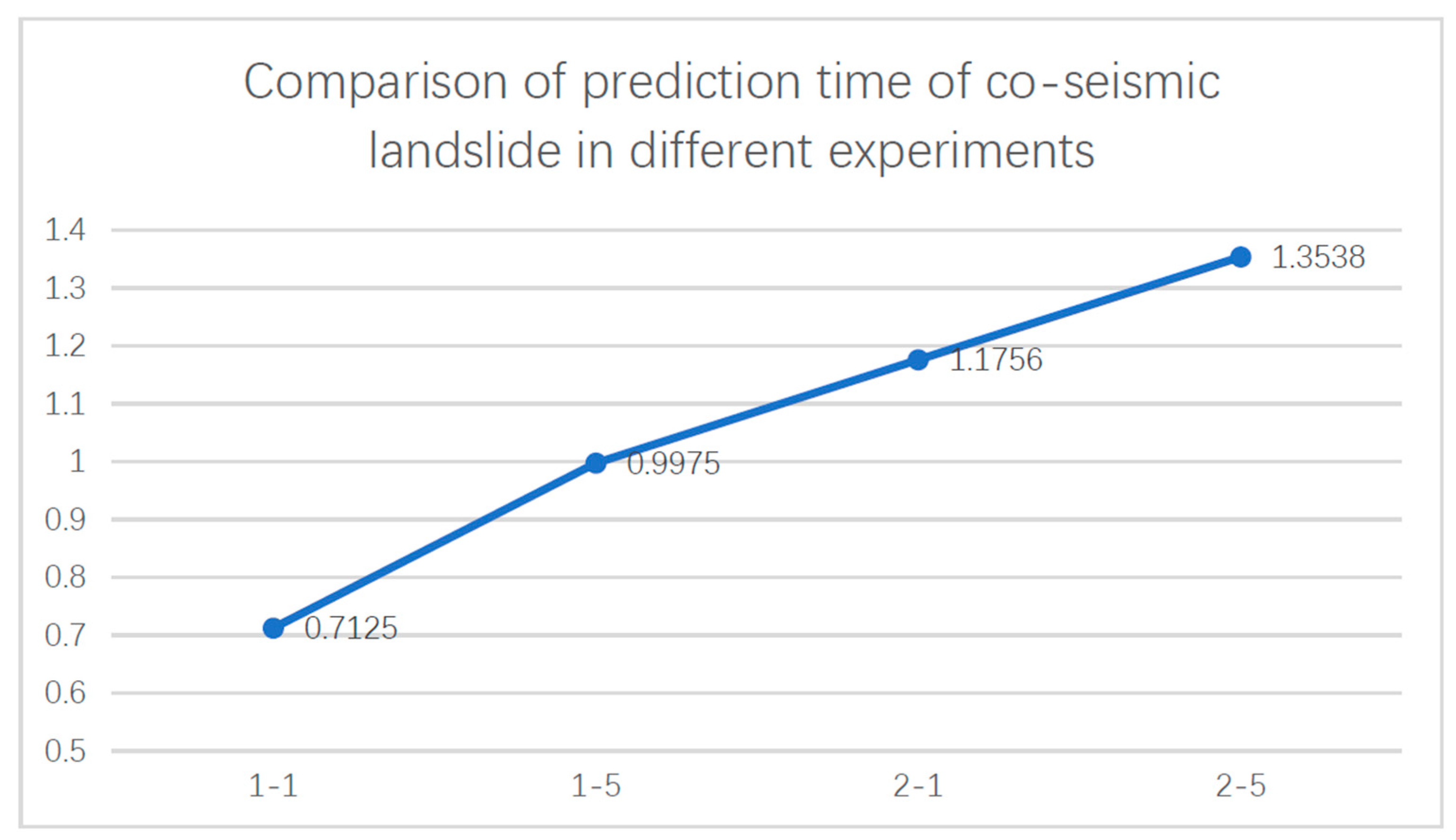
| Experiment Number | Experiment | |||
|---|---|---|---|---|
| Feature Input | Model (Backbone Network) | Training Epochs | ||
| Feature Selection | Number of Bands | |||
| 1-1 | Image (RGB) | 3 | U-Net | 50 |
| 1-2 | DeepLab V3+ (ResNet18) | 50 | ||
| 1-3 | DeepLab V3+ (ResNet34) | 50 | ||
| 1-4 | DeepLab V3+ (ResNet50) | 50 | ||
| 1-5 | DeepLab V3+ (ResNet50) | 100 | ||
| 2-1 | Image (RGB) DEM Slope Aspect | 6 | U-Net | 50 |
| 2-2 | DeepLab V3+ (ResNet18) | 50 | ||
| 2-3 | DeepLab V3+ (ResNet34) | 50 | ||
| 2-4 | DeepLab V3+ (ResNet50) | 50 | ||
| 2-5 | DeepLab V3+ (ResNet50) | 100 | ||
| Num | Precision | mIou | Recall | F-1 Score |
|---|---|---|---|---|
| 1-1 | 0.660389 | 0.708744 | 0.566244 | 0.609704 |
| 1-2 | 0.632827 | 0.717469 | 0.620872 | 0.626793 |
| 1-3 | 0.631112 | 0.724469 | 0.648415 | 0.639647 |
| 1-4 | 0.717093 | 0.747202 | 0.641909 | 0.677421 |
| 1-5 | 0.749731 | 0.750279 | 0.683364 | 0.715011 |
| 2-1 | 0.643282 | 0.713783 | 0.597672 | 0.619639 |
| 2-2 | 0.692092 | 0.73331 | 0.619586 | 0.653835 |
| 2-3 | 0.664166 | 0.740159 | 0.668856 | 0.666503 |
| 2-4 | 0.728748 | 0.750367 | 0.641902 | 0.682574 |
| 2-5 | 0.796203 | 0.760474 | 0.672002 | 0.728404 |
Disclaimer/Publisher’s Note: The statements, opinions and data contained in all publications are solely those of the individual author(s) and contributor(s) and not of MDPI and/or the editor(s). MDPI and/or the editor(s) disclaim responsibility for any injury to people or property resulting from any ideas, methods, instructions or products referred to in the content. |
© 2023 by the authors. Licensee MDPI, Basel, Switzerland. This article is an open access article distributed under the terms and conditions of the Creative Commons Attribution (CC BY) license (https://creativecommons.org/licenses/by/4.0/).
Share and Cite
Zheng, X.; Han, L.; He, G.; Wang, N.; Wang, G.; Feng, L. Semantic Segmentation Model for Wide-Area Coseismic Landslide Extraction Based on Embedded Multichannel Spectral–Topographic Feature Fusion: A Case Study of the Jiuzhaigou Ms7.0 Earthquake in Sichuan, China. Remote Sens. 2023, 15, 1084. https://0-doi-org.brum.beds.ac.uk/10.3390/rs15041084
Zheng X, Han L, He G, Wang N, Wang G, Feng L. Semantic Segmentation Model for Wide-Area Coseismic Landslide Extraction Based on Embedded Multichannel Spectral–Topographic Feature Fusion: A Case Study of the Jiuzhaigou Ms7.0 Earthquake in Sichuan, China. Remote Sensing. 2023; 15(4):1084. https://0-doi-org.brum.beds.ac.uk/10.3390/rs15041084
Chicago/Turabian StyleZheng, Xiangxiang, Lingyi Han, Guojin He, Ning Wang, Guizhou Wang, and Lei Feng. 2023. "Semantic Segmentation Model for Wide-Area Coseismic Landslide Extraction Based on Embedded Multichannel Spectral–Topographic Feature Fusion: A Case Study of the Jiuzhaigou Ms7.0 Earthquake in Sichuan, China" Remote Sensing 15, no. 4: 1084. https://0-doi-org.brum.beds.ac.uk/10.3390/rs15041084