Article

Numerical Study on Microclimate and Outdoor Thermal Comfort of Street Canyon Typology in Extremely Hot Weather—A Case Study of Busan, South Korea

1
Department of Architecture, Pusan National University, Geumjeong-gu, Busan 46241, Korea
2
Department of Architecture, School of Human Settlement and Civil Engineering, Xi’an Jiaotong University, Xi’An 710049, China
*
Author to whom correspondence should be addressed.
Submission received: 3 January 2022 / Revised: 4 February 2022 / Accepted: 9 February 2022 / Published: 11 February 2022

Abstract

:
As cities are extremely vulnerable to the impacts of climate change, they are fundamental in addressing these changes. However, streets, which are external spaces accessed by citizens in daily life, play an important role in improving the urban environment and public health. This study considered Busan in South Korea as a case study to investigate street canyons, including street canyon geometries and tree configurations, of old, present, and new city centers. The influence of morphological factors on the microclimate and outdoor thermal comfort was evaluated using the ENVI-met program for extremely hot weather. Changes in the street width, street orientation, and street canyon aspect ratio had a significantly higher impact on the microclimate and thermal comfort index (p < 0.01). These results indicated that the orientation of the main street should be consistent with the prevailing wind direction of Busan. Further, the shading of adjacent buildings improved the outdoor thermal comfort and reduced the significance of tree configuration in deeper street canyons. In addition, tree height had a more significant impact on street environment than other tree configuration factors, especially when the tree height increased from 9 m to 12 m. We recommended that the thermal comfort level can be improved by dynamically adjusting the relationship between the planting distance and tree height in streets having shallow street canyons.

1. Introduction

Rapid urbanization has further strengthened the urban heat island (UHI) effect [1] and promoted frequent occurrences of extreme weather events [2,3]. The impacts of urbanization on the local atmospheric circulation have been demonstrated in previous studies [4]. Extremely hot weather is associated with high risks to cardiovascular health, especially for adults with pre-existing cardiovascular diseases [5]. Thus, mitigating urban environmental problems is fundamental for successful sustainable urban development in the future [6]. Moreover, the COVID-19 pandemic has notably influenced the urban environment, economy, and urban transportation [7]. Therefore, it is necessary to re-examine the existing urban plans and execute transformative actions to create sustainable cities and communities (Sustainable Development Goal 11) [8,9]. The United Nations Environment Programme launched the “Share the road” plan to encourage citizens to walk or ride bicycles to alleviate urban environmental problems [10]. Street, which is the most basic and important space for urban functions and daily life, and which is associated with organic activities, is a primary component of the master plan of a city [11]. Geometric characteristics of the underlying urban surfaces [12,13] and physical properties of building materials [14] not only affect the microclimate environment but also affect the whole urban climate.
Studies have evaluated the UHI effect, urban climate disasters [15], and the thermal environment of residential areas [16,17,18,19] and campus areas [20,21]. With the expansion of cities, the building density and floor area ratio of new cities far exceeded those of old cities; thus, the new cities have become centers of strong UHI effects [22]. Furthermore, land use change forcing on green infrastructure in the subsequent decades may affect the capacity of urban areas in adapting to extreme weather conditions [23]. Micro-scale green infrastructure can effectively improve the thermal environmental conditions of urban areas at the micro-scale [13]. In urban centers, practical building geometry and landscape planning can decrease heat stress and air pollutant levels of blocks, thereby providing comfortable environmental conditions in summer [24,25]. Many studies have discussed the effects of building morphology and street surface materials on urban heat stress, and overheating mitigation strategies in highly dense cities through field measurements or numerical simulations [26,27,28,29,30,31]. In addition, the Urban Weather Generator tool can be used to correct the weather station data for districts where a weather station is far from the research area or for districts that lack proper measurement equipment, and this data can be input as forcing data for the model [32,33]. Shading achieved by a high street canyon aspect ratio can reduce air temperature (Ta) and mean radiant temperature (MRT), thereby improving the thermal environment of streets [34]. Increased Ta in the street intersections and street canyon contributes to the thermal comfort among residents [27]. Street canyon aspect ratio and street orientation can have a considerable effect on street thermal comfort, which is mainly affected by exposure to solar radiation [35]. Moreover, the street canyon aspect ratio is a crucial factor for reducing the peak building cooling demand [36]. However, vegetation studies have mainly focused on the micro-scale to reduce Ta, improve thermal comfort, and promote pollutant diffusion. A study conducted on a park in Berlin showed that the spatial configuration and vegetation type of green areas jointly affected the efficiency of the cooling effect of green areas [37]. Another study conducted on a university campus in Italy showed that the presence of vegetation promoted optimum values of MRT, predicted mean vote, and physiological equivalent temperature (PET) [38]. Tree species and areas covered with large trees ensure improved thermal comfort, with higher comfort in double rows of trees than in centered tree plantations [39,40,41]. In-canyon vegetation exhibits a relatively larger cooling effect during daytime than at night [42]. Tree height, crown diameter, and volume are primary factors affecting the pedestrian level of particulate matter reduction ratio, whereas leaf area index (LAI) has a comparatively low influence [43]. However, trees block the airflow in street canyons, which leads to higher pollutant concentrations [44].
Outdoor thermal comfort is affected by the external microclimate and internal factors of humans (such as human physiology, psychology, and thermal balance). These internal factors also significantly affect the outdoor thermal comfort [45]. Owing to the multiple factors influencing urban streets, systematically quantifying the effectiveness of these factors is necessary to formulate urban street planning guidelines. However, previous studies have discussed the influence of only 2–3 factors, such as street geometry and vegetation, on microclimate and outdoor thermal comfort. Simultaneous assessment of multiple factors will help provide renewal and planning guidelines for the regeneration and development of urban areas.
In this context, many evaluation models have been developed to study and predict microclimate and thermal comfort in recent years. ENVI-met is widely used in microclimate and thermal comfort assessments because it can simulate the interaction between buildings, vegetation, soil, and atmosphere. By comparing measurement and simulation data, ENVI-met can reproduce surface temperature, Ta, and relative humidity [46,47,48]. It can also simulate the impact of tree factors on the surrounding environment in complex urban environments [49,50]. Simulated results of previous studies have shown a strong fit with measured values under different building geometrical and meteorological conditions [51,52,53,54,55]. These studies verified the suitability of ENVI-met in studying the effects of building geometry and vegetation on the urban microclimate and thermal environment.
In summary, both street geometry and vegetation have a strong impact on microclimate and outdoor thermal comfort. Most previous studies have only focused on some variables, such as street geometry or vegetation, and have not considered the comprehensive effects of these factors when evaluating characteristics of microclimate and thermal comfort. In addition, they were mostly aimed at tropical, cold, and arid regions, with their results being difficult to apply in other climate regions. To fill these gaps, this study aimed to comprehensively evaluate the microclimate characteristics (i.e., Ta, WVEL, and MRT) of pedestrian areas and the thermal comfort (i.e., PET index) under extremely hot weather by quantifying the impacts of street canyon geometry and street tree configuration to propose the improvement strategies of outdoor thermal environment using microclimate software ENVI-met. This study considered Busan, which is located in a subtropical humid region, as a case study, and typical street canyon factors were selected according to field measurements. Based on microclimate and thermal comfort of pedestrian levels, this study further aimed to provide a reference for street planning to regenerate old cities and develop new cities experiencing extremely hot weather.

2. Materials and Methods

In this study, the main streets in the old, present, and new city centers of Busan were considered as the study areas, and their street canyon geometry and street tree configuration were investigated. Based on field measurement results, seven factors were selected, and 32 scenarios were generated using the Taguchi method. Using ENVI-met to simulate the microclimate and thermal comfort of 32 scenarios in extremely hot weather, the importance and variation characteristics of different factors of pedestrian height on the microclimate and thermal comfort were analyzed.

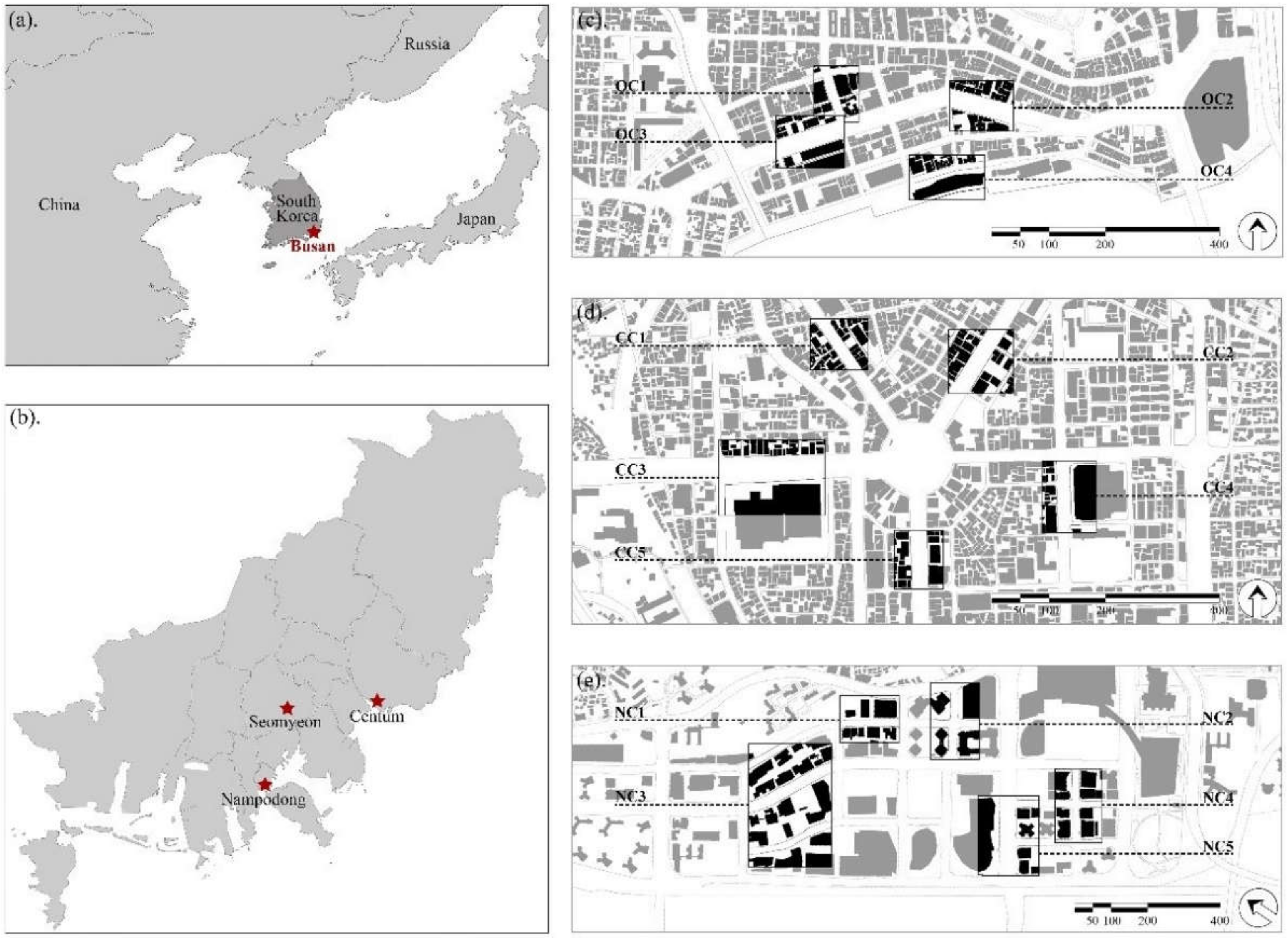
2.1. Site Description

Busan (35°05′ N, 128°35′ E), the south-easternmost tip of the Korean Peninsula (Figure 1a), is the economic, cultural, and educational center of southeast Korea. The study areas of Nampodong, Seomyeon, and Centum city represent the old, present, and new city centers, and are collectively known as Busan’s three core business districts (Figure 1b). Nampodong is characterized by low buildings, with building units comprising mainly 2–5 floors (F), and scattered buildings above 6 (F). Subway station exits on both sides of the main street. The density of street trees is sparse and the crowns of the existing trees are small. Other streets are narrow and have less vegetation. Building units of Seomyeon included mainly 5–12 (F), and the building height, and the scale and street width of the main road are larger than those of Nampodong. However, the vegetation characteristics of Seomyeon are similar to those of Nampodong. Building height and scale of Centum are significantly larger than those of Nampodong and Seomyeon with the highest building reaching 51 (F) (187 m). The main street width and plant coverage ratio are also the largest and street trees are uniformly planted on both sides of the street. Shrubs, which are absent in the other districts, are planted in Centum. The terrain of the three districts is approximately horizontal, and most streets in Nampodong and Centum are mainly facing NE–SW or SE–NW directions.
The mean annual temperature of Busan is 14.7 °C and its summer precipitation is 778.7 mm, accounting for 51.2% of the annual precipitation. According to the Köppen–Geiger climate classification, Busan falls under a dry-winter humid subtropical climate (Cwa) zone [56]. The Automated Synoptic Observing System data obtained from the Korea Meteorological Agency indicated that the highest air temperature recorded till date was 37.3 °C on 14 August 2016 (Figure 2a). However, the lowest relative humidity was observed at the beginning of June and the end of August. In addition, Busan is affected by the monsoon in summer, and the prevailing direction of wind at a speed of 2.1–3.0 m/s (Figure 2b) is South by Southwest (SSW).
To explore the characteristics of street canyons, representative plots were selected for field measurements using Laser Range-finder in the three districts (Figure 1c–e), and the corresponding results are shown in Table 1. In terms of street canyon geometry, street width (WS) represented the distance between building façades along the street, including lane width, sidewalks, and open space width in front of buildings. Street canyon aspect ratio (HB/WS) was the ratio of building height to street width. The average WS of Centum (36–67 m) was significantly wider than that of Nampodong and Seomyeon. However, the average HB/WS ratio of Centum was not majorly different from that of Seomyeon. Only two areas showed ratios of 2.4 and 2.8, whereas the remaining plots showed a ratio of within 2.0 in the Centum. In terms of tree configuration, the distance between the trees and buildings (DB–T) was calculated as the distance from the building façade to the tree trunk. Planting distance (DT–T) was the space between the tree trunks that occurred symmetrically on both side of the streets. As trees were close to the buildings, tree height (HT) was obtained by estimating the top position of the crowns projected parallel to the building façades by measuring the single-story building height. Nampodong and Seomyeon had few trees, most of which were unevenly planted on both sides of the streets; additionally, the tree species in each plot were different. Due to the small DB–T and to ensure that the natural lighting of buildings was not affected, the tree crowns were excessively pruned despite the high HT. In contrast, the street trees of Centum, dominated by Zelkova which were evenly distributed on both sides of the streets, had a larger DB–T, and crowns were not excessively pruned. Shrubs were not considered in this study because they were present only in Centum, and because they were less affected by the microclimate.

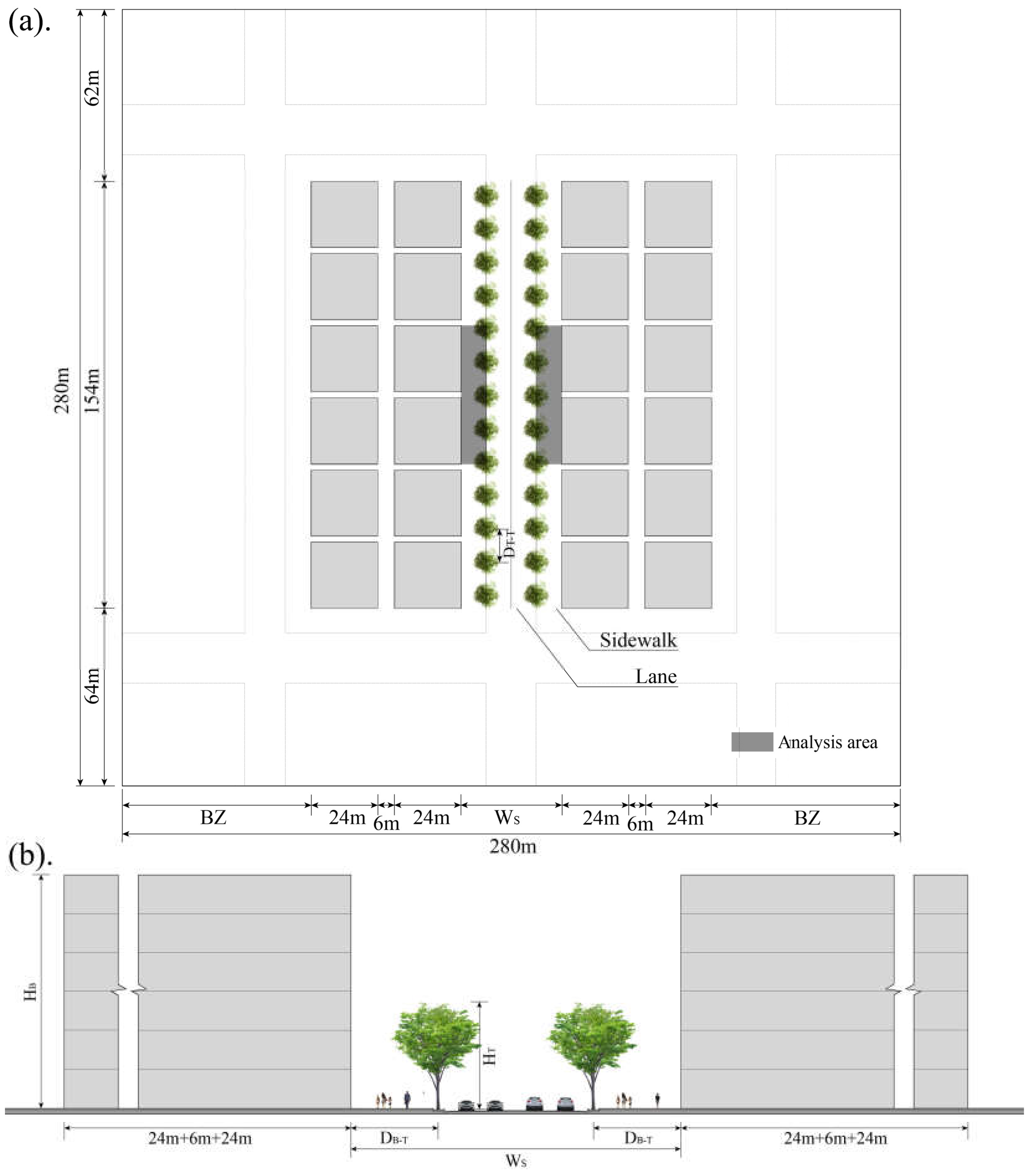
2.2. Setting the Street Canyon Scenario

2.2.1. Parametric Simulation Using Taguchi Method

The Taguchi method is an experimental design method pioneered by Dr. Genichi Taguchi in the 1950s [57]. It is commonly used for achieving robust design and thus is also known as the Taguchi Method of Robust Design. It uses statistical methods to conduct experiments and control the production process to achieve the dual purpose of improving product quality and reducing costs, and has extensive applications in biology, engineering, agriculture, and advertising [58]. It mainly selects an appropriate orthogonal array according to the design parameters, including control factors and level values, acquires large-scale data using the least number of experiments, and obtains the degree of influence on factors through analysis of variance (ANOVA).
In this study, factors such as street width (WS), street orientation (OS), street canyon aspect ratio (HB/WS), distance between trees and buildings (DB–T), planting distance (DT–T), tree height (HT), and LAI were set in the order as shown in Table 2 based on field measurements. Most streets had less vegetation when WS was less than 24 m, and central vegetation was observed when WS was over 60 m. OS was simulated by considering four standard directions and HB/WS represented the cross-sectional shape of street canyons. Considering that building height will increase in the future, the range of the simulated HB/WS values was slightly higher than those acquired by field measurements. Tree configuration setting was not only based on field measurements but also on the street landscape guidelines of other countries. For example, DB–T was set to 4.5 m for narrow streets and 5.5 m for new streets in London; further, DB–T was set to 7.6 m for new streets and DT–T was set to 6–12 m based on the tree size in the United States of America [59,60,61]. According to the landscape guidelines in China, the distance between the crown underside and ground should be greater than 2 m in the pedestrian-only street, and greater than 3.5 m in the bus lane in China [62,63]. LAI is a measure of the total area of leaves per unit ground area and is directly related to the light that can be intercepted by plants. It is a dimensionless entity characterizing the canopy of an ecosystem and is a key component of biogeochemical cycles in ecosystems [64]. Therefore, LAI is an important factor to be considered due to varying conditions of the tree crowns. The field measurement results found that Zelkova is the main street tree species. All the vertical and horizontal crown structures of tree crowns were taken as examples of Zelkova.
In this study, the Taguchi method was used to select a L32 (49) orthogonal array to generate 32 scenarios (Table 3). This orthogonal array can generally select up to nine factors with four parameters to be studied; however, in this study only seven factors with four parameters were selected and the remaining two unused columns were left empty. The two columns were left empty because of the need to verify whether there is a correlation between the street canyon geometry factors. However, the analysis results showed that the p values were far greater than 0.05, which is not statistically significant. Therefore, no analysis was performed in the “Result” section.

2.2.2. Basic Model Description

According to the field measurements, most street lengths between the main intersections were approximately 150 m. A secondary road or branch road was present between the main intersection to facilitate traffic and the land was divided into rectangular blocks. Twelve single buildings were established in the rectangular blocks on both sides of the street to simplify the simulation (Figure 3). The roof and façade materials of buildings were composed of concrete, the lanes between two rows of street tree were composed of asphalt, and the sidewalk pavements between trees and buildings were composed of concrete to simulate the underlying surface of an impermeable environment. In addition, the lane material of the buffer zones was also composed of the same material as that used for the middle streets. The remaining blocks were composed of concrete. The specific physical parameters of material were set as default values in ENVI-met.
Data collected from a height of 1.4 m above the ground surface were used as the output data. The analysis area is shown in Figure 3. The average value of the analysis area in each scenario was considered for further data analysis.

2.3. Microclimate Simulation Using ENVI-Met

2.3.1. ENVI-Met Description

The ENVI-met software is a widely used prognostic, three-dimensional model developed by Bruse and Fleer [65] based on computational fluid dynamics and thermodynamics for modeling air, surface, and vegetation interactions to simulate the turbulence, moisture, radiation flux, and microclimate in outdoor environments. ENVI-met analyzes the effects of small-scale and meso-scale changes in urban design (e.g., trees, backyard greening, and new building constellations) on microclimate with a spatial resolution of 0.5–10 m and a temporal resolution of 10 s. It allows the user to surround domains with nesting grids to improve the stability of the lateral boundary conditions [66]. Moreover, it consists of 1D boundary model, 3D atmospheric, soil model, and vegetation model as sub-models. The analytical model is based on Navier-Stokes equations for wind flow, atmospheric flow turbulence equations, energy and momentum equations, and boundary condition parameters [32]. Model structure and mathematical equations of sub-models were provided by Tsoka et al. [67] and Huttner [68]. The high spatiotemporal resolutions of ENVI-met provided more precise outputs for Ta, relative humidity, WVEL, MRT, and solar radiation, thereby providing a better understanding of microclimate effects at the street-scale.

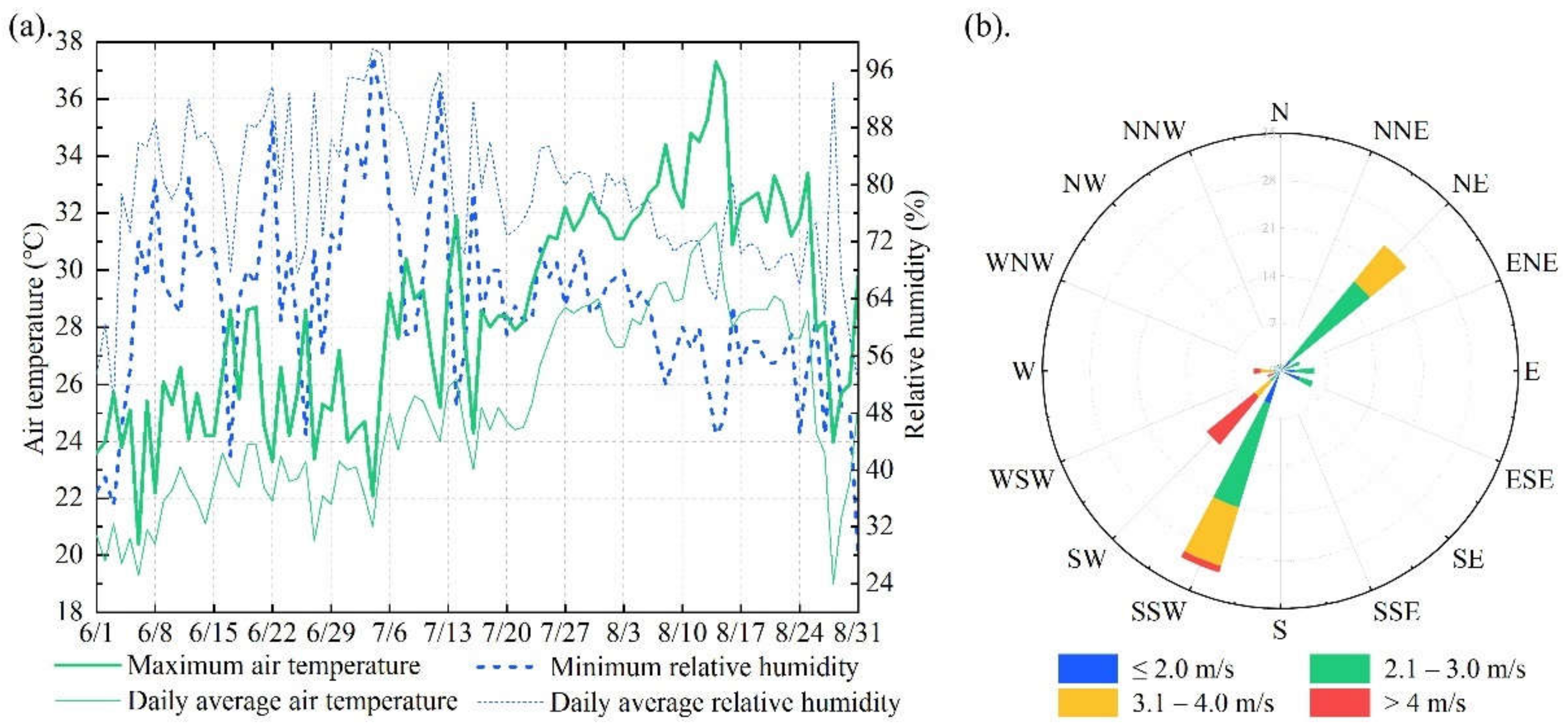
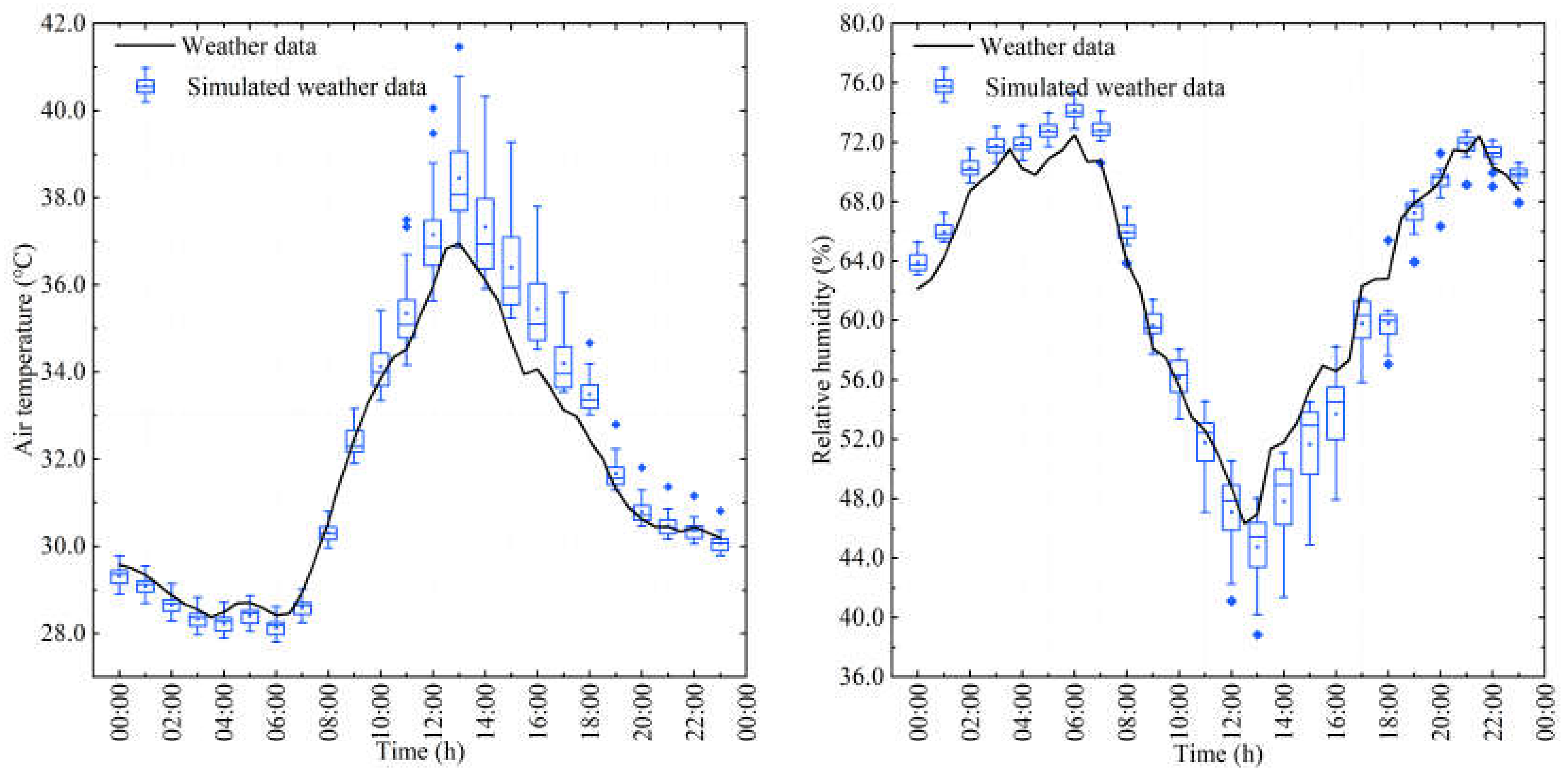
2.3.2. Weather Data Input for Simulation

The simulation was initiated on 13 August 2016, and data were used on 14 August 2016, for analyses. Precipitation and cloud cover were not observed before and after the simulation period. To guarantee the stability of the simulation process, this study adopted boundary conditions of full forcing for air temperature and relative humidity. Considering the instantaneous nature and randomness of WVEL and direction, the amount of model calculations increased, wind flow turbulence became unstable and caused errors. Therefore, this study adopted the prevailing wind direction of Busan in summer from SSW and a wind speed of 2.8 m/s as input parameters. Further details are presented in Table 4.
The unit grid size was set to 2 m × 2 m × 2 m, with a domain having dimensions of 280 m × 280 m (L × W). Five nesting grids were added around the main model to minimize the edge effect and to ensure the validity of the simulation. The vertical boundary of the domain was set to 2 HB, where HB is the height of the highest building.

2.4. Parametric Setting of Thermal Comfort Index

PET is a human bio-meteorological parameter that describes the thermal perception of an individual. To calculate the physiological parameters, PET uses the Munich energy balance model for individuals [69]. Further description and classifications are given in [70] and [71]. Biomet, a plugin in ENVI-met, can calculate the thermal comfort index by interacting directly with the atmosphere results and it can also set personal human parameters. The efficiency of PET for tropical, subtropical, and temperate regions has been verified among the existing studies on the thermal comfort index [72], which is widely used in the field.
Considering these advantages, this study used PET to assess the effects of street canyons on in-canyon thermal comfort, and personal human parameters were set as shown in Table 5.

2.5. Data Extraction Tool for NetCDF Files from ENVI-Met

There are two different types of output files in ENVI-met: simple text files and binary files (EDX/EDT). The main output files were stored in binary format and were accessed and visualized by Leonardo in the ENVI-met software. In addition, the built-in NetCDF program in ENVI-met supports the conversion of EDX/EDT files into .nc files for storage. Although the software can set receptors before the beginning of simulation, if users intend to analyze other point data or certain area data, the corresponding data must be exported separately through Leonardo. In this study, combined with the structurale characteristics of the .nc file, which is the output in ENVI-met, a data extraction tool was developed using Python. Users can enter coordinate information according to their requirements to limit the three-dimensional area. Moreover, up to five data types can be exported to an Excel file for data segregation and further analyses.

3. Results

3.1. Characteristics of the Street Microclimate on the Pedestrian Level

ANOVA was used for analyzing the orthogonal experiment design results. The priority order of research factors and mitigation plan was determined through the analysis results. Figure 4 shows the diurnal changes in air temperature and relative humidity from all simulated scenarios (box plots) in the pedestrian area and weather data (dashed line). Maximum air temperature and minimum relative humidity were observed at 13:00. Further, the weather data underestimated the air temperature from 13:00 to 19:00 in the pedestrian area, thus indicating that considering the microclimate effect of street canyons is necessary. This study focused on the simulated data at 13:00 and diurnal changes to study the effects of the characteristics of street canyon geometry and tree configuration on the microclimate and thermal comfort changes of the pedestrian areas. The selected analysis factors of the microclimate were Ta, WVEL, and MRT, while the PET was reflected by the thermal comfort index.

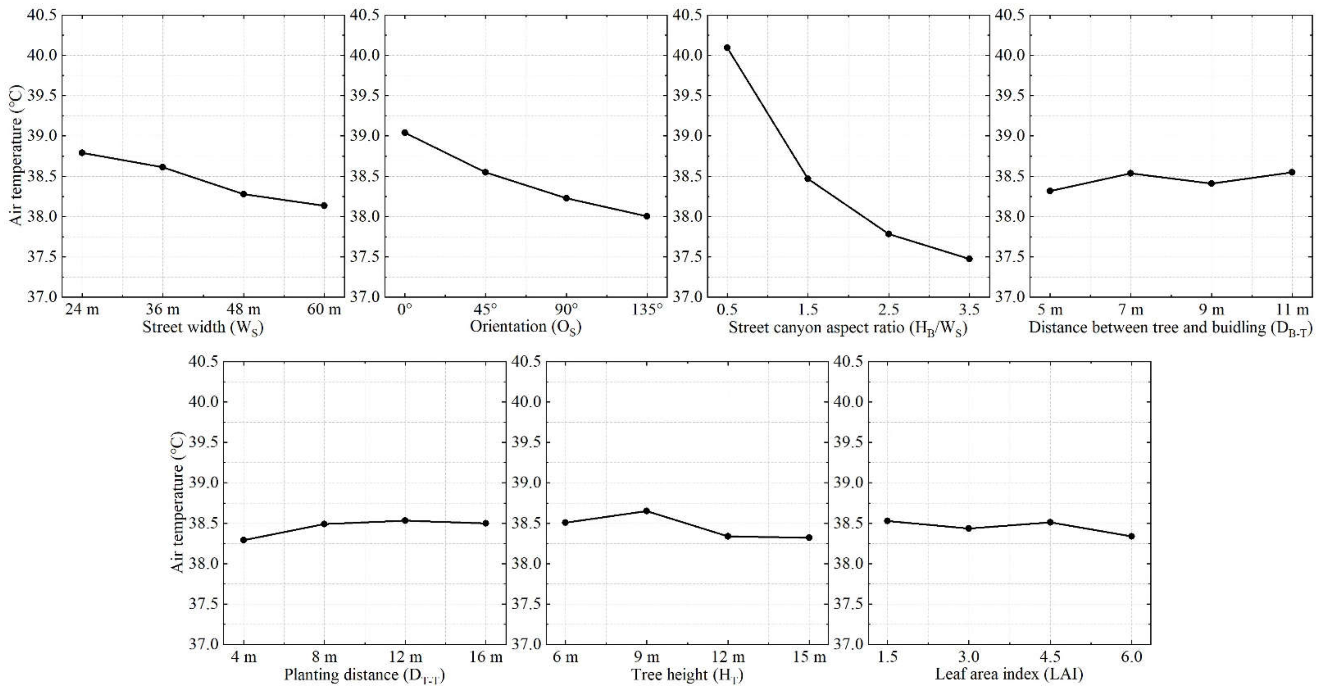
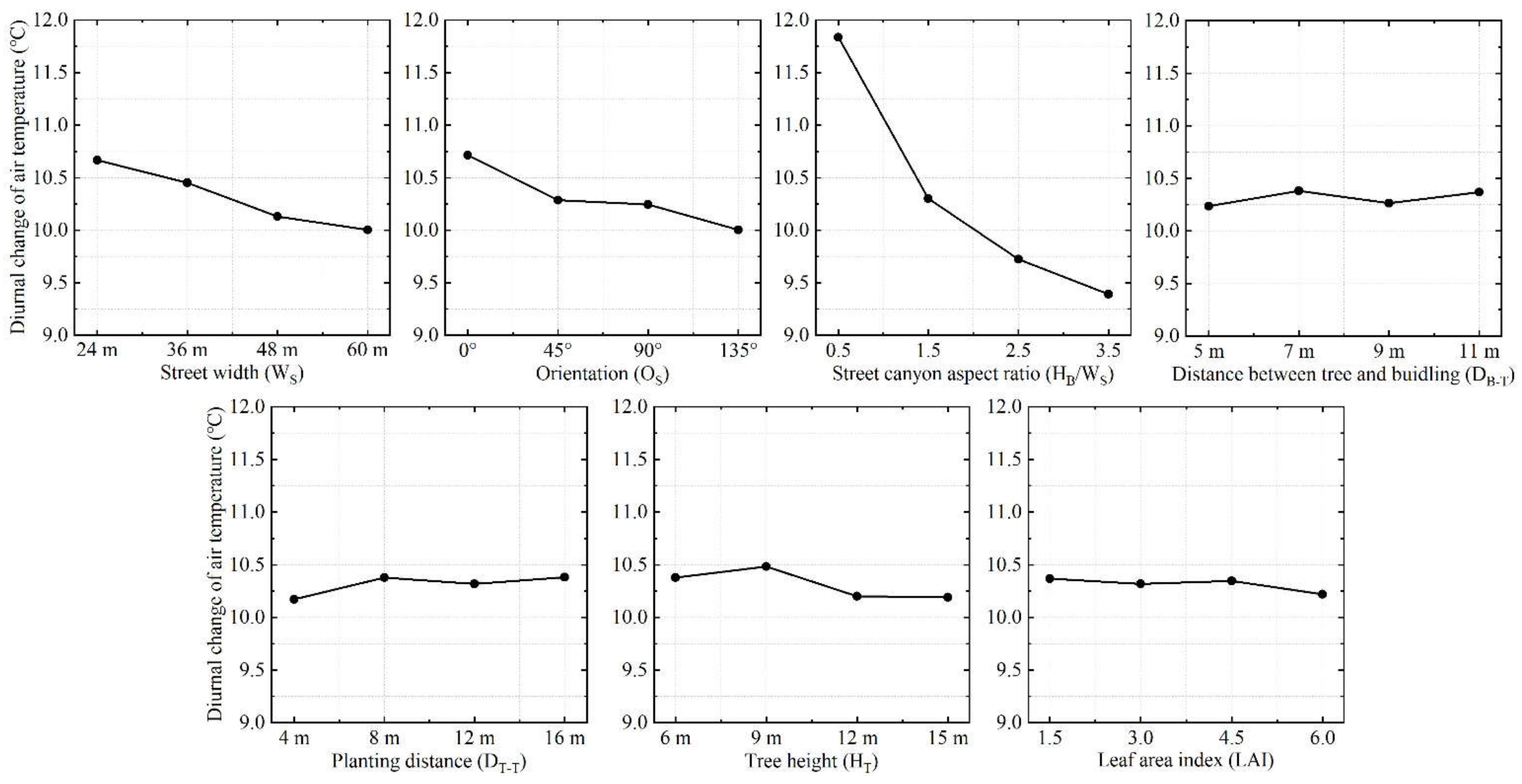
3.1.1. Influence of Air Temperature (Ta)

Thermal comfort of the pedestrian area was affected by the microclimate. The effect of street canyon geometry and tree configuration factors against Ta at 13:00 was studied using ANOVA (Figure 5 and Table 6). WS, OS, and HB/WS were statistically significant (p < 0.01), indicating a strong relationship with Ta. Building and artificial surfaces were heated due to high solar radiation at noon, and subsequently released the captured heat to the air through heat exchange. Ta decreased as HB/WS increased due to the increase of the shading area; likewise, this relationship between Ta and HB/WS was also improved by Morakinyo and Lam [39]. Further, Ta was higher for the 0° streets than the 45° streets because of the higher heat gain in the artificial surface before 13:00, and Ta was lower for the 90° and 135° streets than the other two directions due to the shading effect. Moreover, it was lower for the 135° street than the 90° street because wind speed was slightly higher. Wind speed increased with the increase in WS (see Section 3.1.2 for further details), which in turn increased both convective heat transfer intensity near the ground and heat dispersion. The effect of tree configuration was lower than street canyon geometry at 13:00. Yang and Lan [73] reported the median improvement effect of ground greening on Ta at 0.65 °C and reported that the maximum value did not exceed 1.0 °C. DT–T (p = 0.010, p < 0.05) and HT (p = 0.025, p < 0.05) were more significant than DB-T and LAI. Ta did not decrease over 0.4 °C irrespective of the tree configuration. These results indicated that the street trees had a limited effect on Ta reduction. Smaller DT–T and higher HT had more cooling effect, suggesting that larger tree crowns are preferred to promote the cooling effect, especially in shallow street canyons as reported by other studies [39,42,74]. Although the significance of DB–T and DT–T was not high, the results were similar to those reported by Li et al. [29], but the Ta differences in this study were slightly more than those observed when DB–T and DT–T changed. This could be because of the selection of different study sites, with Li et al. [29] focusing on Harbin, China, which has a higher dimension as well as weaker Ta and solar radiation in summer than in Busan.
Tamin was observed at 6:00 and the differences between the scenarios were small compared with those observed at 13:00. The diurnal changes between Tamin and Tamax, were mainly affected by the maximum value (Figure 6 and Table 7). WS (p = 0.001), OS (p = 0.001), and HB/WS (p = 0.000) significantly affected the diurnal changes. Huang and Li [36] reported a less significant correlation between WS and the Ta near the building façade. This result was contrary to the results observed in this study because Huang and Li [36] used typical meteorological year data from EnergyPlus as the input data. The input WVEL was only 0.07 m/s, indicating almost windless conditions in the simulation scenarios. Convective heat transfer intensity weakened during the windless condition, but as WS increased, the heated area within the street increased, which in turn increased the average daily Ta. In this study, the input WVEL was 2.8 m/s, and the convective heat transfer intensity was much greater than the reference scenarios. Therefore, larger WS, results in lower Ta and higher correlation between Ta and WS. Due to shading of the adjacent buildings, the heat gain of the buildings and artificial surfaces was reduced, resulting in smaller diurnal changes in deeper street canyons. The cooling effect was affected by the changes in the shadow as the sun moved during daytime and by wind speed during nighttime. However, the influence of solar radiation dominated the major effects during changes in OS, especially in the afternoon due to high radiation heating in the air. In terms of the tree configuration, DT–T (p = 0.027, p < 0.05) and HT (p = 0.012, p < 0.05) were statistically significant, but the influence of HT can be neglected when it exceeds 12 m. Diurnal changes were higher when DT–T was less than 8 m, which followed the findings of Huang and Li [36]. The influence of DB–T and LAI was less evident. Therefore, higher greening rate showed stronger heat storage capacity to reduce the diurnal changes of Ta.

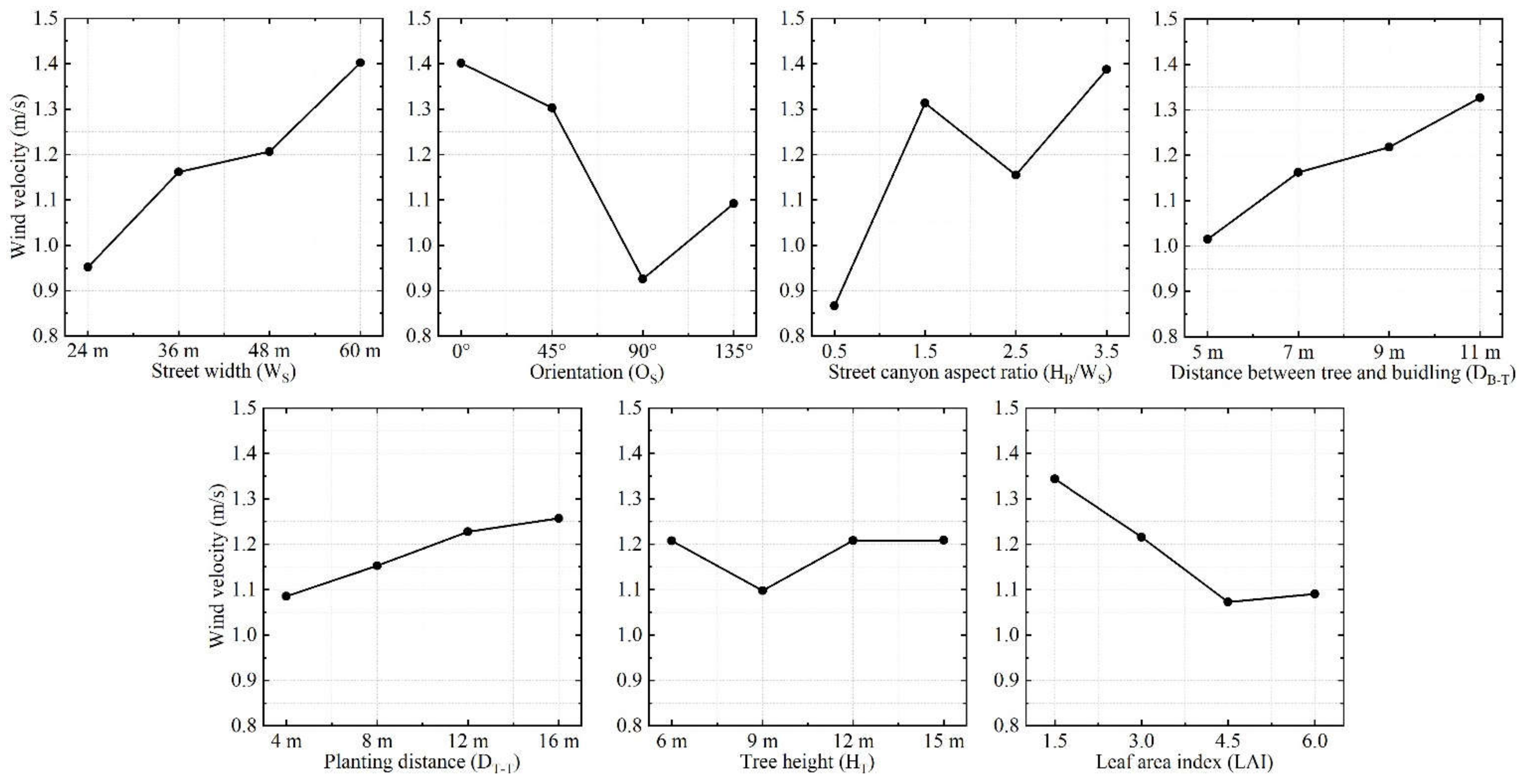
3.1.2. Influence of Wind Velocity (WVEL)

The presence of high-rise buildings in the city center has changed the original WVEL and direction. The presence of main streets in the same direction as the prevailing wind direction can reinforce the WVEL in the streets, and increase the surface convection heat transfer intensity, thereby increasing the streets’ thermal comfort. However, if streets are perpendicular to the prevailing wind direction, the buildings can block the wind, resulting in areas with low WVEL or the absence of wind in the streets. The taller the building, the more severe the wind resistance. As shown in Figure 7 and Table 8, WS, OS, and HB/WS significantly influenced WVEL (p < 0.01). WVEL initially decreased and then increased when HB/WS exceeded 1.5 due to influence of downward wind. The WVEL results of Huang and Li [36] did not evidently show this trend due to small WVEL input. In this study, the input wind direction was 200° (North was 0°) and approximately S–SW. The angles between the wind direction and OS were 20°, 25°, 70°, and 65° based on the prevailing wind direction in summer of 2016. Thus, smaller the angles, higher the WVEL in the pedestrian area. Further, WVEL in the street canyon was affected by the resistances caused by WS and tree density. Thus, the larger the WS and DB–T, the lower the wind resistance, and vice versa. Therefore, WVEL was high during high WS and DB–T values, consistent with the reports of Deng and Wong [28]. In addition, DB–T (p = 0.040, p < 0.05) and LAI (p = 0.045, p < 0.05) significantly affected WVEL. Higher LAI implied thicker tree crowns, which increased the wind resistance. However, this effect diminished when LAI was over 4.5. Although the influence of DT–T was less significant, linear growth was observed because wind resistance decreased with an increase in DT–T. In addition, WVEL dropped abruptly when HT was 9 m. This indicates the possibility of an interaction with other environmental factors. Because of the limited degrees of freedom and limitation of factorial column in the orthogonal array, the speculated interaction could not be further quantified.
In this study, the prevailing wind direction and average WVEL, which remained unchanged, were used as input during summer. Diurnal changes in WVEL were small in the streets (less than 0.1 m/s). Therefore, these diurnal variations of WVEL were not considered in this study.

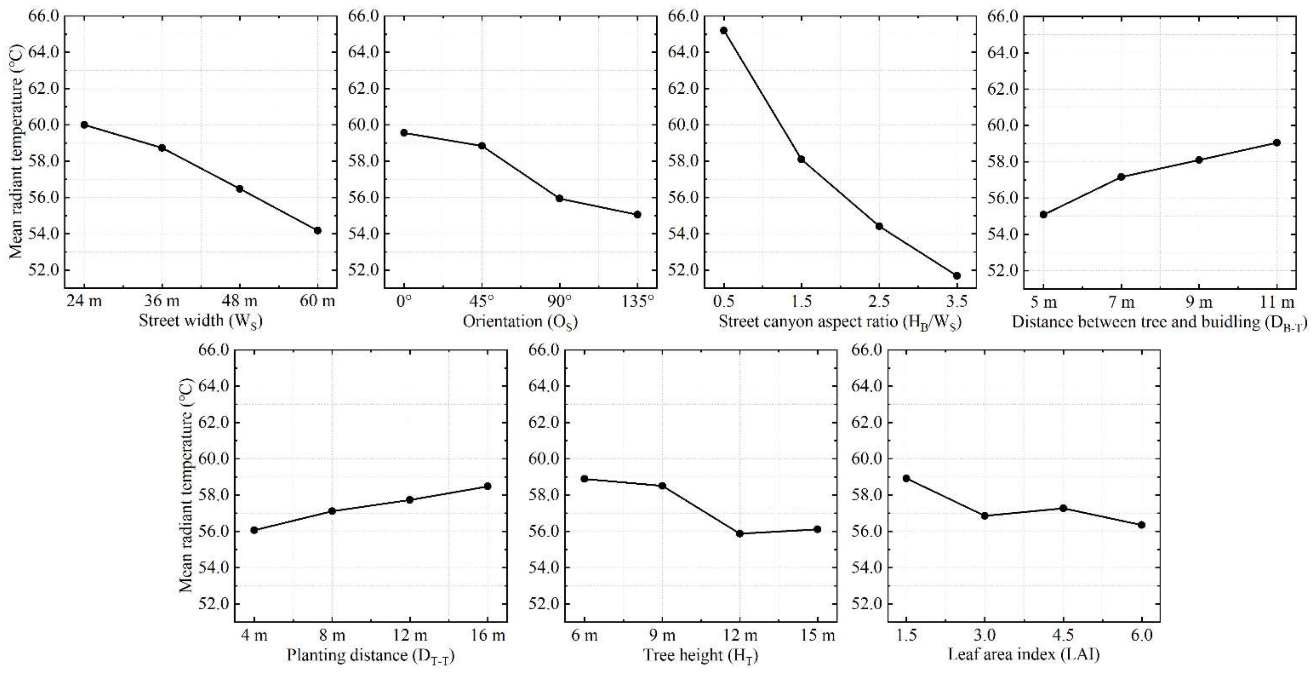
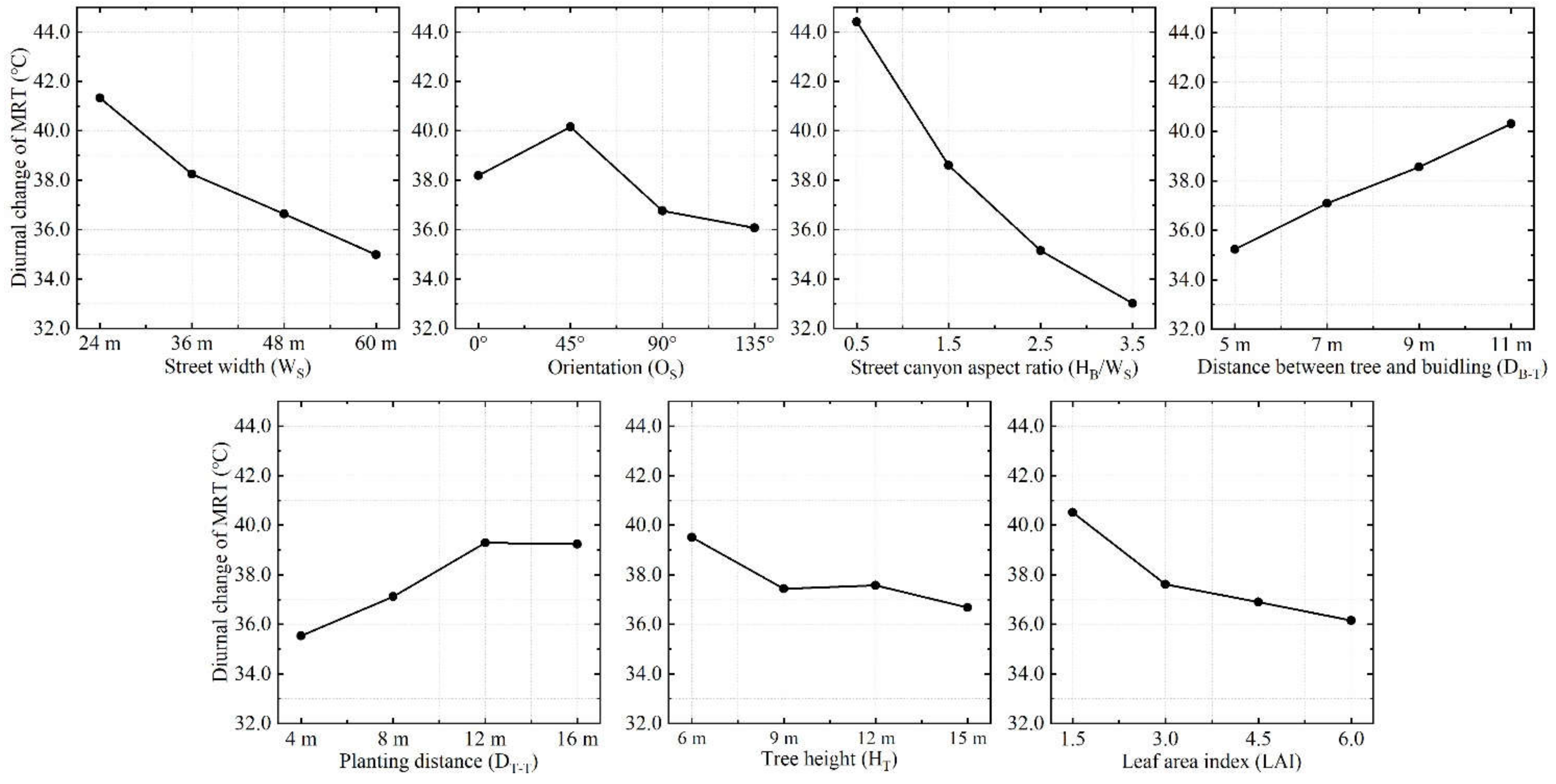
3.1.3. Influence of Mean Radiant Temperature (MRT)

MRT is one of the most important meteorological parameters controlling human energy balance and thermal comfort. Artificial surfaces are more sensitive to radiation and have high emittance compared with natural surfaces. WS, OS, HB/WS, and HT significantly affected MRT (p < 0.01), whereas the significant influence of DB–T (p = 0.029) and DT–T (p = 0.023) was lower than the abovementioned four factors (Figure 8 and Table 9). The influence of HB/WS on MRT was significantly more with a range of 13.50 °C because buildings prevent shortwave radiations emitted from the sun to reach the ground surface. As WS increased, MRT gradually decreased due to the influence of Ta and WVEL. Streets oriented at 0° and 45° were directly exposed to the sun during noon and the corresponding shading area was small, resulting in the MRT being significantly higher than the other two orientations. MRT was mostly affected by tree shades because it depends on radiative fluxes (especially direct shortwave radiations) in shallow street canyons. Li et al. [29] reported that different effects of DB–T and DT–T on MRT during varying OS values. Low DT–T increased the radiation from the trees, whereas high DT–T increased the solar radiation the pedestrian areas. This study found that larger the DB–T and DT–T, higher is the MRT, suggesting that smaller DB–T and DT–T are preferred to mitigate MRT, especially during low HB/WS because of increased solar radiation. Low DT–T and high HT increased the greening rate, which prevented the shortwave solar radiation from reaching the pedestrian area and building surfaces. This also prevented heated building surfaces from emitting longwave radiation. HT had a reducing effect on MRT, which diminished when HT was over 12 m, from where the effect of trees could be neglected. Although the effect of LAI was less evident, large LAIs reduced transmissivity and prevented radiation to decrease MRT.
The MRT value was the highest at 14:00 in the 45° street due to direct solar radiation and longwave radiation from artificial surfaces, but the highest MRT value in other scenarios was observed at 13:00. Diurnal changes showed a strong significant correlation with the seven factors (p < 0.01) (Figure 9 and Table 10). Shallow street canyon showed high diurnal changes due to the lack of mutual shading from adjacent buildings. The wider the WS, the greater the heat dissipation of longwave radiation to the sky, resulting in a lower diurnal change. The 45° streets received more solar radiation and heat dissipation from artificial surfaces at 14:00, thus, these streets faced the highest diurnal changes. The diurnal changes of MRT for OS were affected by shadow changes as the sun moved in the daytime, especially in the afternoon. Moreover, higher diurnal changes were observed for trees with larger DB–T, and trees with smaller LAI. Larger DB–T caused higher fluctuation of MRT in buildings and artificial surfaces. Smaller LAI caused higher transmittance, and more radiation could enter the buildings and artificial surfaces, leading to high diurnal change. Larger DT–T showed a reduction effect on the diurnal changes of MRT, and this effect decreased when DT–T was more than 12 m, from where the effect of trees can be neglected. Generally, the evapotranspiration from trees with high HT and large crowns was relatively stronger. In addition, street trees with high HT but scattered canopy in the pedestrian area could attenuate solar radiation up to 43% compared with short trees having dense leaves under the same LAI [39].

3.2. Characteristics of Changes in the Street Thermal Comfort (PET Index) on the Pedestrian Level

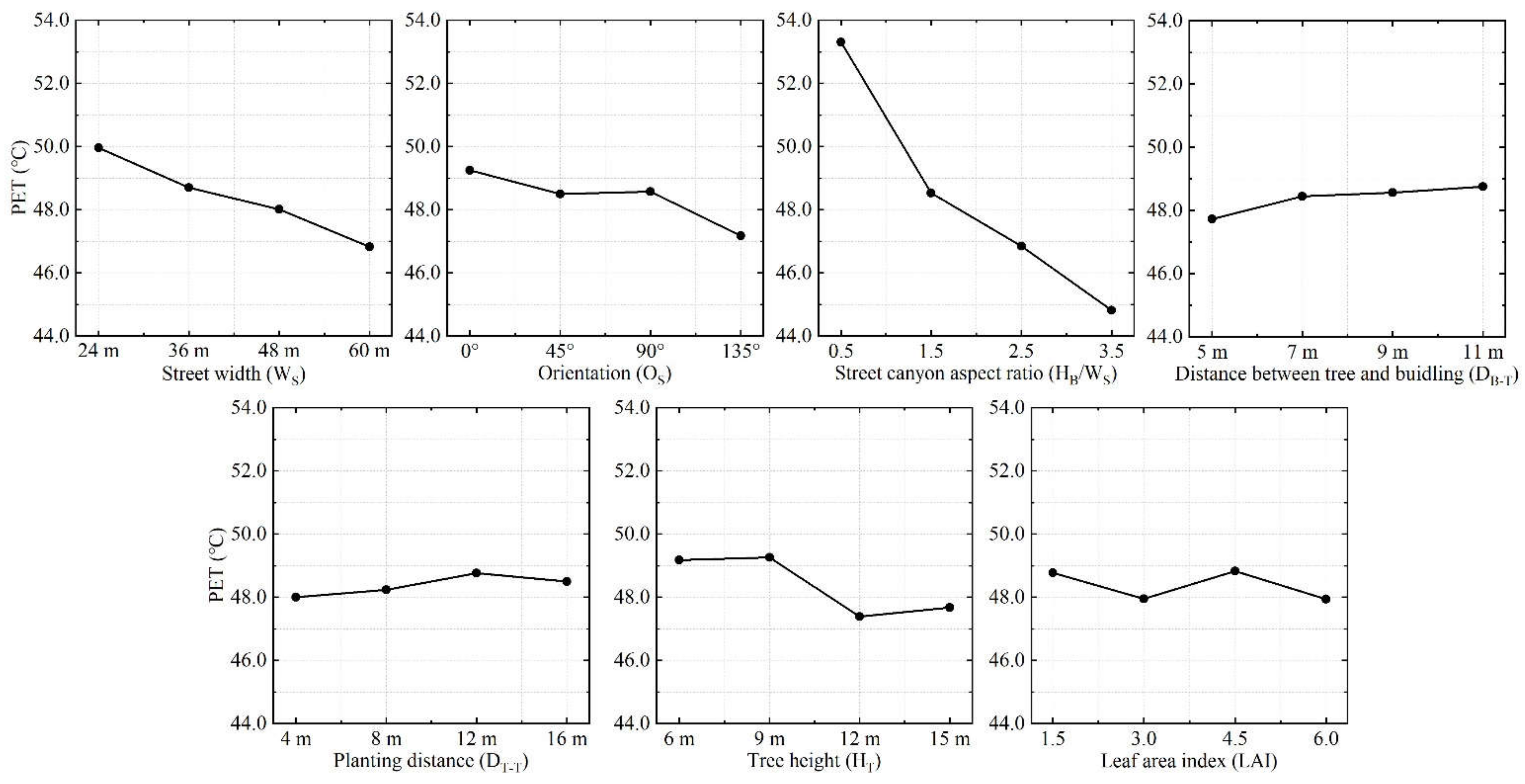
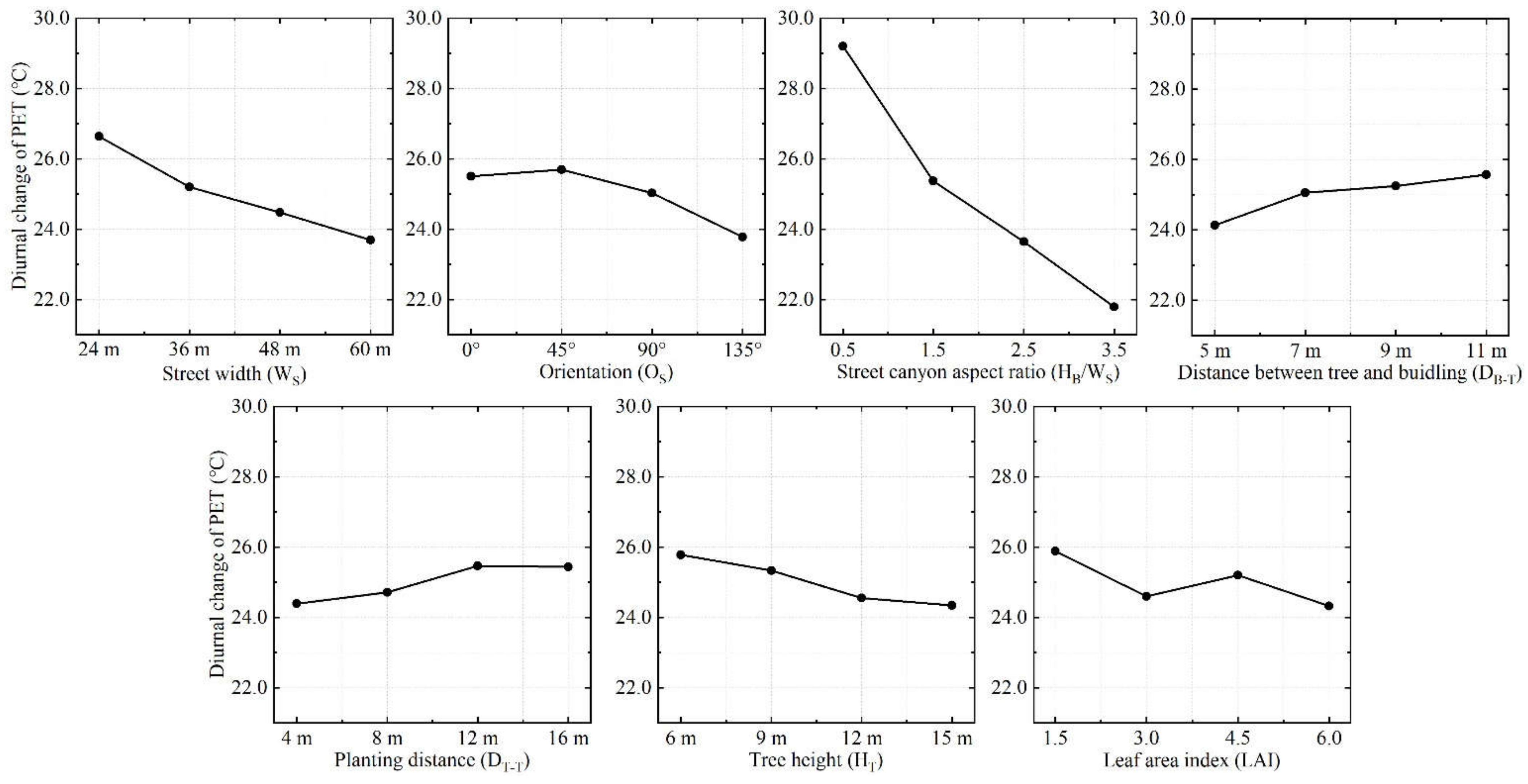
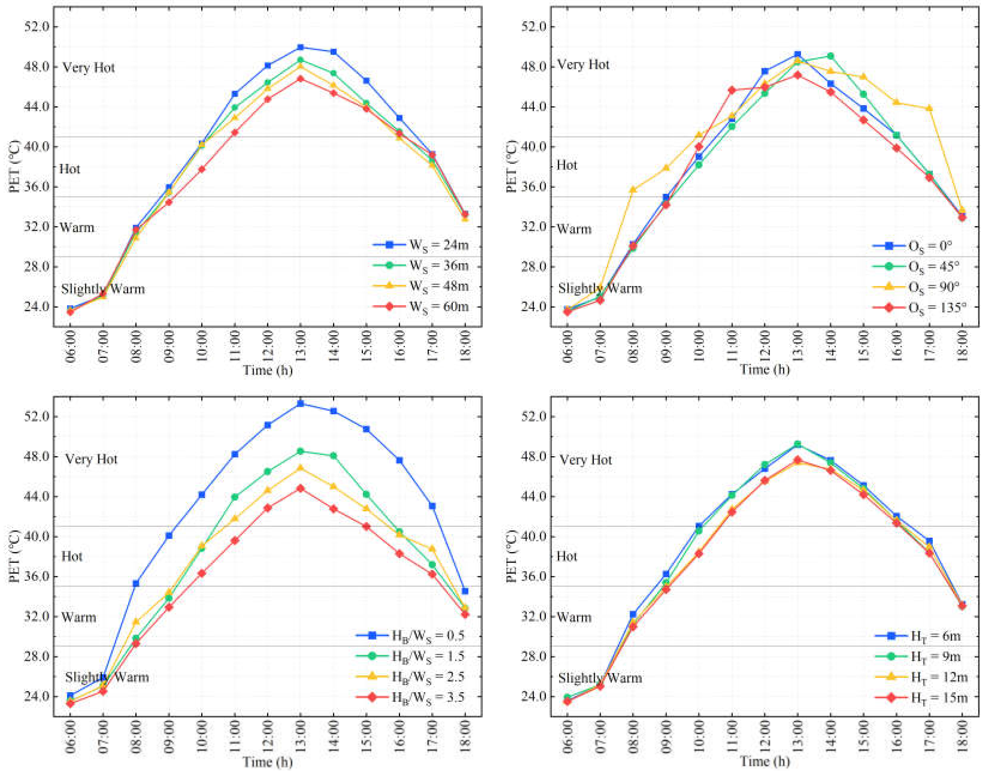
3.2.1. Influence of PET

Thermal comfort refers to the state where most people are physiologically and psychologically satisfied with the objective thermal environment. Generally, comprehensive analysis is conducted from physical, physiological, and psychological aspects. Section 2.5 explains the input parameters of PET. As shown in Figure 10 and Table 11, WS, OS, HB/WS, and HT were statistically significant to PET (p < 0.01). The PET changes ranged between 44.8 °C and 53.3 °C, which exceeded the “Very Hot” standards according to the grades of thermal sensitivity [75]. The shaded area of the buildings decreased the PET in the deeper street canyons with both sides of the pedestrian area and the underlying building surface falling under the shaded area. The PET in the deep street canyons was driven by the accumulated heat and other radiative fluxes, but not by shortwave radiation. Another important factor that significantly affected the PET reduction capability was WS due to increased WVEL, which dissipated more heat from the street. The impact of HB/WS was approximately 2.7 times the impact of WS from the range value. The solar elevation angle for OS was the maximum at noon, causing the building and artificial surfaces to heat up and radiate the heat to streets, which resulted in the highest Ta, MRT, and PET in the streets oriented at 0°. PET reduced significantly when HT was 9–12 m, and was the lowest at 12 m. The effect of DB–T on PET was less significant, but it also increased linearly as DB–T increased. Compared with the HT and DB–T results from Yang et al. [41], the changes in the peak PET in this study were slightly more, but the overall trends of PET changes were similar to the findings of this study. As the reference literature examined the 0° and 90° streets, and WS and the building heights were relatively small, street trees were necessary elements to improve the thermal comfort of the pedestrian areas. This study considered more factors than previous studies, and thus, the changes in DB–T and DT–T may be affected more by changes in the street canyon geometry. According to Morakinyo and Lam [39], PET increased as LAI increased on the 0° street. Further, the maximum reduction was observed when the LAI was the highest and vice-versa. The differences of LAI may be affected by the OS. Thus, quantitative studies on the impacts of LAI should be conducted for different OS.
PET was most affected by MRT. The occurrence time of the highest PET value was consistent with that of MRT. WS, OS, HB/WS, HT, and DT–T significantly affected PET (p < 0.01) (Figure 11 and Table 12). The effect of LAI (p = 0.032) and DB–T (p = 0.083) was more significant than the other five factors. The reasons for the diurnal changes of WS, OS, and HB/WS were the same as those for MRT. Further, the effects of mutual shading from adjacent buildings had a greater impact on PET than wind speed in the pedestrian area. The trees with larger crowns showed greater cooling and humidification effect, which could effectively reduce the diurnal changes in PET. Moreover, DT–T showed a reduction effect; however, this effect diminished when DT–T was larger than 12 m, from where the effect of trees could be neglected. Higher greening rate had a better reduction effect for PET. Moreover, although LAI and DB–T were less significant, greater PET reduction due to diurnal changes was observed with small DB–T and large LAI.

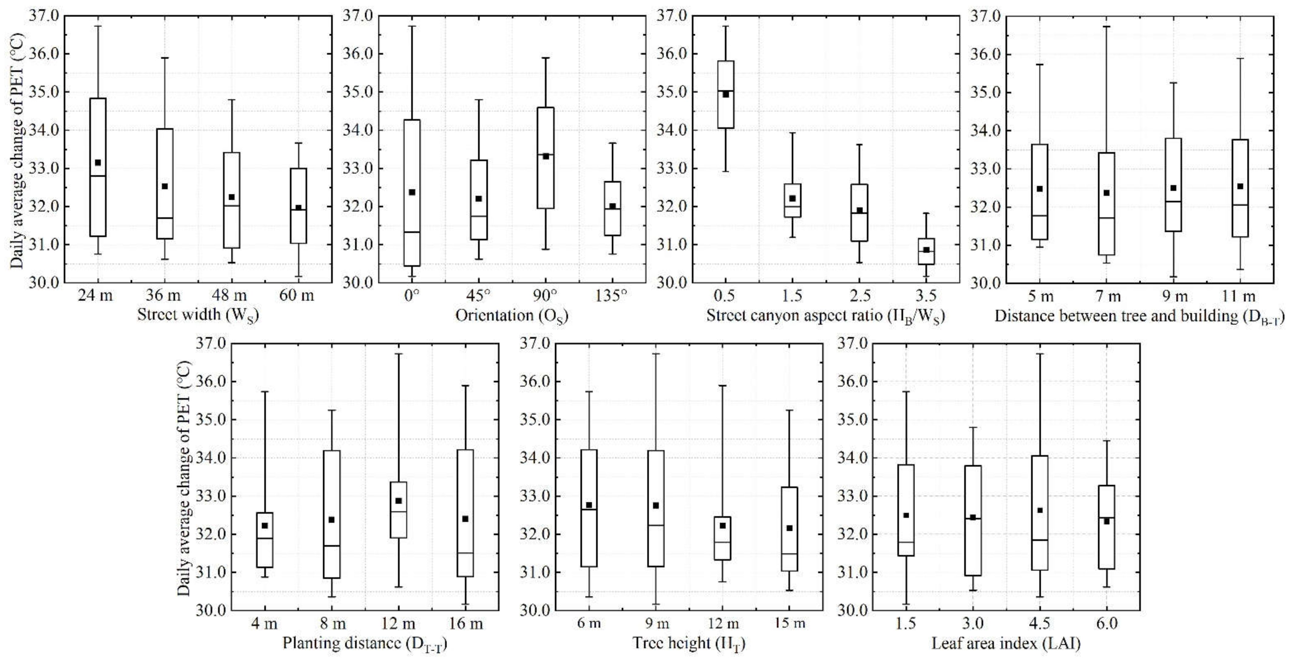
3.2.2. Daily Average Change of PET

In this section, the impacts of street canyon geometry and tree configuration on the thermal comfort during the hottest day are discussed from the perspective of daily average changes of PET. It shows that thermal comfort of the pedestrian area was promoted from the perspective of planning and designing the street canyon of the city center. The ANOVA results showed that the effects of WS (p = 0.014), OS (p = 0.003), HB/WS (p = 0.000), and HT (p = 0.048) on PET were statistically significant (p < 0.05). As shown in Figure 12 and Table 13, HB/WS dominated most effects on the daily average changes of PET with a range of 4.06 °C. The wider the WS, the smaller is the fluctuation range of daily average changes. The daily average value was the highest in the 90° street, but the fluctuation range was the largest in the 0° street. Further, the influence of solar radiation on the daily average changes in PET in the afternoon was significantly greater than in the morning and evening based on analyses. HT was statistically significant and the fluctuation range was the largest when HT was 9 m, and it was the smallest when HT was 12 m. In addition, the influence of DB–T, DT–T, and LAI was less significant (p > 0.05). The greater the DB–T and DT–T, greater the daily average change in PET, and larger the LAI, the smaller is the daily average of PET.
The characteristics at 13:00, diurnal changes, and the daily average values of PET for different factors were studied. The effects of WS, OS, HB/WS, and HS were statistically significant (p < 0.05). Moreover, the differences in various factors between 0:00–6:00 and 18:00–24:00 had a marginal effect on PET; thus, a PET curve of four factors between 6:00–18:00 was selected for analysis (Figure 13). Further, there was an uncomfortable thermal comfort period in the daytime, during which PET was more than neutral (18–23 °C). The lowest PET was observed at 6:00, and it gradually increased from 6:00 to 12:00, and decreased after 12:00. However, the highest PET was observed at 14:00 in the 135° streets. In terms of WS, the PET of 24 m, 36 m, and 48 m streets reached the “Hot” level at 9:00, whereas the 60 m street reached this level at 10:00. Between 11:00 and 16:00, all WS values reached the “Very Hot” level, but as WS increased, the PET value decreased. After 16:00, the PET difference gradually decreased. It is evident that narrow streets could be more uncomfortable due to poor air circulation. In terms of OS, PET showed an evident increasing trend in the 90° street from 6:00 to 8:00. Moreover, the PET of the 90° street was significantly higher than streets at other orientations during 8:00–10:00 and 15:00–17:00. The PET of the 135° street increased slowly after 11:00, until it reached a maximum value (47.17 °C) at 13:00, but this value was lower than the values observed for other orientations. The area exposed to solar radiation on the 45° street increased after 12:00 and reached a maximum value (49.07 °C) at 14:00. In addition, the total duration of the “Hot” and “Very Hot” levels in the 90° street was 10 h, whereas that of other orientations was 8 h. The 0° and 90° streets showed different characteristics with the changes reported by Yang et al. [41]. It is speculated that the input WVEL, wind direction, and intensity of local solar radiation caused the differences in PET during daytime. Yang et al. [41] also indicated that PET was significantly correlated with the shortwave direct radiation quality. PET for HB/WS = 0.5 was always highest and PET for HB/WS = 3.5 was lowest in the daytime. The total duration of the “Very Hot” level was 8 h when HB/WS was 0.5, whereas the total duration decreased to 3 h when HB/WS was 3.5. In addition, the difference was more obvious between 11:00 and 15:00 when HB/WS was 1.5 and 2.5, respectively. HT did not differ considerably between 6 m, 9 m, 12 m, and 15 m. However, the difference was greater between 8:00 and 14:00 when HT increased from 9 m to 12 m. Further, a marginal difference was observed between 8:00 and 10:00 when HT increased from 6 m to 9 m, and the difference gradually decreased, especially between 13:00 and 15:00 when there was almost no difference.

4. Discussion

To improve the microclimate and street thermal comfort in summer especially during extremely hot weather, various factors should be combined, e.g., improved street wind condition [43], practical street orientation [28,36], and landscape planning [25,76] as suggested by Lai et al. [77].
In this study, street canyon geometry showed a greater impact on the microclimate and thermal comfort of the pedestrian areas than tree configuration. Shading of the adjacent buildings prevented the solar radiation from reaching the artificial surfaces, improving thermal comfort in the pedestrian areas of deeper street canyons. This reduced the significance of tree configuration in deep street canyons. In addition, Busan, a coastal city, was more affected by WVEL and wind direction than the inland areas [78]. Street orientation was more consistent with the prevailing wind direction, and wider streets had more air influxes, which increased the dissipation of heat from the street canyons. In the tree configuration, the influence of HT on the microclimate and thermal comfort was higher than DB–T, DT–T, and LAI. Further, increasing the greening ratio intensified the cooling and humidification effect to improve thermal comfort. The order of importance of the street canyon factors in improving the thermal comfort of the pedestrian area in the city center of Busan was HB/WS > WS > OS > HT > DT–T > DB–T > LAI.
To promote good ventilation potential in Busan, the main street plan should follow the prevailing wind direction, and high-rise buildings should be arranged along the main street while planning a new city. Each block should stipulate a restricted building setback to obtain additional street width. In a city, the temperature of a street is also influenced by the temperature of the surrounding streets, and different street orientations can, therefore, partially compensate for the high temperature in other streets [79]. Further, the length of the blocks in a direction perpendicular to the prevailing wind should be reduced, thereby reducing the length of the street perpendicular to the prevailing wind. An urban ventilation corridor is formed by adjusting the street geometry of main and secondary streets, by appropriately increasing the greening ratio; moreover, a green belt can be established under street trees on both sides of the main street to mitigate pollution [80]. This study indicated that low building height and street width of the old city highly require tree shading, although that will reduce the wind conditions; similar findings were reported by Morakinyo et al. [81]. Furthermore, greening was the most efficient method to improve the urban street thermal comfort in the old city, especially during daytime. Trees with large crowns should be selected to increase the density of planting to obtain more shading areas, improve the outdoor thermal environment, and reduce the impact of extremely hot weather on public health.
Each city has a unique combination of street trees. This study showed that mature trees with a height of approximately 12 m can effectively improve the microclimate and thermal comfort of streets. Urban planners can, thus, transplant mature trees on the streets, but the transplantation cost is large. Therefore, young trees can be transplanted while planning and designing a new city, especially for high street canyon aspect ratio and SE–NW streets.

5. Conclusions

This study investigated multiple factors affecting the microclimate and outdoor thermal comfort of street canyon typology in extremely hot weather using Busan as a case study. Based on the field measurement results, 32 scenarios were generated by considering the street canyon geometry and tree configuration through the orthogonal array of Taguchi method. ENVI-met was used to simulate scenarios and evaluate microclimate and thermal comfort of the pedestrian areas. ANOVA was used to determine the significant effects of microclimate and thermal comfort degree of each factor. The results showed that HB/WS had a significant impact on the microclimate and thermal comfort, followed by WS and OS. The 135° street (SE–NW) showed a shading effect for the pedestrian area, which can effectively ensure thermal comfort in the hottest weather. Changes in the street canyon geometry had a higher impact on the microclimate and thermal comfort than tree configuration. The impact of HT on improving thermal comfort decreased with the increase in the street canyon geometry. This indicated that shallow street canyons require additional greening to improve the microclimate and thermal comfort.
Our study provides significant insights for urban planners on how different street canyon geometries and tree configurations could influence the microclimate and human thermal comfort on the street. While planning a new city, the main street orientation is recommended to be towards the prevailing wind. Further, the length of the short side of the block should be reduced as much as possible to facilitate better overall performances of street thermal comfort. Further, for restoring old cities, selecting taller trees with larger crowns and ensuring sufficient planting distance is necessary to improve thermal comfort. Although none of these scenarios can reverse the long-term effects of the warming trends, rigorously applying various combinations of these strategies can moderate extreme climate events and accelerate the establishment of sustainable cities.

Author Contributions

Conceptualization, J.W. and S.Y.; methodology, J.W., H.C. and S.Y.; software, J.W. and H.C.; validation, S.Y.; formal analysis, J.W., H.C. and S.Y.; investigation, J.W.; resources, J.W.; data curation, J.W.; writing—original draft preparation, J.W.; writing—review and editing, J.W., H.C. and S.Y.; visualization, J.W. and H.C.; supervision, S.Y.; project administration, S.Y.; funding acquisition, S.Y. All authors have read and agreed to the published version of the manuscript.

Funding

This research was funded by the National Research Foundation (NRF), Korea, under project BK21 FOUR; Korea Ministry of Environment (MOE) as 「Graduate School specialized in Climate Change」; and National Research Foundation of Korea (NRF) grant funded by the Korea government (MSIT) (No. NRF-2017R1E1A1A01074904).

Institutional Review Board Statement

Not applicable.

Informed Consent Statement

Not applicable.

Data Availability Statement

Data available on request.

Acknowledgments

This research was supported by the National Research Foundation (NRF), Korea, under project BK21 FOUR; Korea Ministry of Environment (MOE) as 「Graduate School specialized in Climate Change」; and National Research Foundation of Korea (NRF) grant funded by the Korea government (MSIT) (No. NRF-2017R1E1A1A01074904).

Conflicts of Interest

The authors declare no conflict of interest.

References

  1. Oke, T.R. The Energetic Basis of the Urban Heat Island. Q. J. R. Meteorol. Soc. 1982, 108, 1–24. [Google Scholar] [CrossRef]
  2. Hammond, M.J.; Chen, A.S.; Djordjević, S.; Butler, D.; Mark, O. Urban Flood Impact Assessment: A State-of-the-Art Review. Urban Water J. 2015, 12, 14–29. [Google Scholar] [CrossRef] [Green Version]
  3. Wang, D.; Lau, K.K.-L.; Ren, C.; Goggins, W.B.I.; Shi, Y.; Ho, H.C.; Lee, T.-C.; Lee, L.-S.; Woo, J.; Ng, E. The Impact of Extremely Hot Weather Events on All-Cause Mortality in a Highly Urbanized and Densely Populated Subtropical City: A 10-Year Time-Series Study (2006–2015). Sci. Total Environ. 2019, 690, 923–931. [Google Scholar] [CrossRef] [PubMed]
  4. Kim, G.; Lee, J.; Lee, M.-I.; Kim, D. Impacts of Urbanization on Atmospheric Circulation and Aerosol Transport in a Coastal Environment Simulated by the WRF-Chem Coupled with Urban Canopy Model. Atmos. Environ. 2021, 249, 118253. [Google Scholar] [CrossRef]
  5. Chaseling, G.K.; Iglesies-Grau, J.; Juneau, M.; Nigam, A.; Kaiser, D.; Gagnon, D. Extreme Heat and Cardiovascular Health: What a Cardiovascular Health Professional Should Know. Can. J. Cardiol. 2021, 37, 1828–1836. [Google Scholar] [CrossRef] [PubMed]
  6. Kenworthy, J.R. The Eco-City: Ten Key Transport and Planning Dimensions for Sustainable City Development. Environ. Urban. 2006, 18, 67–85. [Google Scholar] [CrossRef]
  7. Sharifi, A.; Khavarian-Garmsir, A.R. The COVID-19 Pandemic: Impacts on Cities and Major Lessons for Urban Planning, Design, and Management. Sci. Total Environ. 2020, 749, 142391. [Google Scholar] [CrossRef]
  8. Bereitschaft, B.; Scheller, D. How Might the COVID-19 Pandemic Affect 21st Century Urban Design, Planning, and Development? Urban Sci. 2020, 4, 56. [Google Scholar] [CrossRef]
  9. Teixeira, J.F.; Lopes, M. The Link between Bike Sharing and Subway Use during the COVID-19 Pandemic: The Case-Study of New York’s Citi Bike. Transp. Res. Interdiscip. Perspect. 2020, 6, 100166. [Google Scholar] [CrossRef]
  10. UNEP Share the Road. Available online: http://www.unep.org/explore-topics/transport/what-we-do/share-road (accessed on 19 May 2021).
  11. Ge, J.; Hokao, K. Applying the Methods of Image Evaluation and Spatial Analysis to Study the Sound Environment of Urban Street Areas. J. Environ. Psychol. 2005, 25, 455–466. [Google Scholar] [CrossRef]
  12. Zou, H.; Xu, H.; Zhao, L.; Li, M. The Influence of the Geometric Characteristics of Street Valley on the Wind Environment. In Proceedings of the 11th International Symposium on Heating, Ventilation and Air Conditioning (ISHVAC 2019), Harbin, China, 12–15 July 2019; Wang, Z., Zhu, Y., Wang, F., Wang, P., Shen, C., Liu, J., Eds.; Springer: Singapore, 2020; pp. 989–997. [Google Scholar]
  13. Kim, Y.; An, S.; Eum, J.-H.; Woo, J.-H. Analysis of Thermal Environment over a Small-Scale Landscape in a Densely Built-Up Asian Megacity. Sustainability 2016, 8, 358. [Google Scholar] [CrossRef] [Green Version]
  14. Falasca, S.; Ciancio, V.; Salata, F.; Golasi, I.; Rosso, F.; Curci, G. High Albedo Materials to Counteract Heat Waves in Cities: An Assessment of Meteorology, Buildings Energy Needs and Pedestrian Thermal Comfort. Build. Environ. 2019, 163, 106242. [Google Scholar] [CrossRef]
  15. Kim, K.; Yoon, S. Assessment of Building Damage Risk by Natural Disasters in South Korea Using Decision Tree Analysis. Sustainability 2018, 10, 1072. [Google Scholar] [CrossRef] [Green Version]
  16. Tan, Y.; Liu, G.; Zhang, Y.; Shuai, C.; Shen, G.Q. Green Retrofit of Aged Residential Buildings in Hong Kong: A Preliminary Study. Build. Environ. 2018, 143, 89–98. [Google Scholar] [CrossRef]
  17. Allegrini, J.; Dorer, V.; Carmeliet, J. Influence of Morphologies on the Microclimate in Urban Neighbourhoods. J. Wind. Eng. Ind. Aerodyn. 2015, 144, 108–117. [Google Scholar] [CrossRef]
  18. Wu, J.-D.; Lee, J.-H.; Yoon, S.-H. An Analysis on Micro-climate Characteristic of Apartments in Beijing, China Using ENVI-met Simulation. J. Archit. Inst. Korea Struct. Constr. 2019, 35, 169–176. [Google Scholar]
  19. Yang, Y.; Zhou, D.; Wang, Y.; Ma, D.; Chen, W.; Xu, D.; Zhu, Z. Economical and Outdoor Thermal Comfort Analysis of Greening in Multistory Residential Areas in Xi’an. Sustain. Cities Soc. 2019, 51, 101730. [Google Scholar] [CrossRef]
  20. Zhang, A.; Bokel, R.; van den Dobbelsteen, A.; Sun, Y.; Huang, Q.; Zhang, Q. An Integrated School and Schoolyard Design Method for Summer Thermal Comfort and Energy Efficiency in Northern China. Build. Environ. 2017, 124, 369–387. [Google Scholar] [CrossRef]
  21. Kang, G.; Kim, J.-J.; Choi, W. Computational Fluid Dynamics Simulation of Tree Effects on Pedestrian Wind Comfort in an Urban Area. Sustain. Cities Soc. 2020, 56, 102086. [Google Scholar] [CrossRef]
  22. Kim, H.; Jung, Y.; Oh, J.I. Transformation of Urban Heat Island in the Three-Center City of Seoul, South Korea: The Role of Master Plans. Land Use Policy 2019, 86, 328–338. [Google Scholar] [CrossRef]
  23. Carter, J.G. Urban Climate Change Adaptation: Exploring the Implications of Future Land Cover Scenarios. Cities 2018, 77, 73–80. [Google Scholar] [CrossRef] [Green Version]
  24. Lauriks, T.; Longo, R.; Baetens, D.; Derudi, M.; Parente, A.; Bellemans, A.; van Beeck, J.; Denys, S. Application of Improved CFD Modeling for Prediction and Mitigation of Traffic-Related Air Pollution Hotspots in a Realistic Urban Street. Atmos. Environ. 2021, 246, 118127. [Google Scholar] [CrossRef]
  25. Wang, Y.; Zacharias, J. Landscape Modification for Ambient Environmental Improvement in Central Business Districts—A Case from Beijing. Urban For. Urban Green. 2015, 14, 8–18. [Google Scholar] [CrossRef]
  26. Jung, S.; Yoon, S. Analysis of the Effects of Floor Area Ratio Change in Urban Street Canyons on Microclimate and Particulate Matter. Energies 2021, 14, 714. [Google Scholar] [CrossRef]
  27. Wai, K.-M.; Yuan, C.; Lai, A.; Yu, P.K.N. Relationship between Pedestrian-Level Outdoor Thermal Comfort and Building Morphology in a High-Density City. Sci. Total Environ. 2020, 708, 134516. [Google Scholar] [CrossRef]
  28. Deng, J.-Y.; Wong, N.H. Impact of Urban Canyon Geometries on Outdoor Thermal Comfort in Central Business Districts. Sustain. Cities Soc. 2020, 53, 101966. [Google Scholar] [CrossRef]
  29. Li, G.; Ren, Z.; Zhan, C. Sky View Factor-Based Correlation of Landscape Morphology and the Thermal Environment of Street Canyons: A Case Study of Harbin, China. Build. Environ. 2020, 169, 106587. [Google Scholar] [CrossRef]
  30. Battista, G.; de Lieto Vollaro, R.; Zinzi, M. Assessment of Urban Overheating Mitigation Strategies in a Square in Rome, Italy. Sol. Energy 2019, 180, 608–621. [Google Scholar] [CrossRef]
  31. Massetti, L.; Petralli, M.; Napoli, M.; Brandani, G.; Orlandini, S.; Pearlmutter, D. Effects of Deciduous Shade Trees on Surface Temperature and Pedestrian Thermal Stress during Summer and Autumn. Int. J. Biometeorol. 2019, 63, 467–479. [Google Scholar] [CrossRef]
  32. Detommaso, M.; Costanzo, V.; Nocera, F. Application of Weather Data Morphing for Calibration of Urban ENVI-Met Microclimate Models. Results and Critical Issues. Urban Clim. 2021, 38, 100895. [Google Scholar] [CrossRef]
  33. Salvati, A.; Kolokotroni, M. Microclimate Data for Building Energy Modelling: Study on ENVI-Met Forcing Data. In Proceedings of the Building Simulation 2019: 16th Conference of IBPSA, Rome, Italy, 2–4 September 2019; pp. 3361–3368. [Google Scholar]
  34. Yang, W.; Wong, N.H.; Lin, Y. Thermal Comfort in High-Rise Urban Environments in Singapore. Procedia Eng. 2015, 121, 2125–2131. [Google Scholar] [CrossRef]
  35. Andreou, E. Thermal Comfort in Outdoor Spaces and Urban Canyon Microclimate. Renew. Energy 2013, 55, 182–188. [Google Scholar] [CrossRef]
  36. Huang, K.-T.; Li, Y.-J. Impact of Street Canyon Typology on Building’s Peak Cooling Energy Demand: A Parametric Analysis Using Orthogonal Experiment. Energy Build. 2017, 154, 448–464. [Google Scholar] [CrossRef]
  37. Sodoudi, S.; Zhang, H.; Chi, X.; Müller, F.; Li, H. The Influence of Spatial Configuration of Green Areas on Microclimate and Thermal Comfort. Urban For. Urban Green. 2018, 34, 85–96. [Google Scholar] [CrossRef]
  38. Detommaso, M.; Gagliano, A.; Marletta, L.; Nocera, F. Sustainable Urban Greening and Cooling Strategies for Thermal Comfort at Pedestrian Level. Sustainability 2021, 13, 3138. [Google Scholar] [CrossRef]
  39. Morakinyo, T.E.; Lam, Y.F. Simulation Study on the Impact of Tree-Configuration, Planting Pattern and Wind Condition on Street-Canyon’s Micro-Climate and Thermal Comfort. Build. Environ. 2016, 103, 262–275. [Google Scholar] [CrossRef]
  40. Kim, H.-J.; Lee, S.-H. Developing the Volume Models for 5 Major Species of Street Trees in Gwangju Metropolitan City of Korea. Urban For. Urban Green. 2016, 18, 53–58. [Google Scholar] [CrossRef]
  41. Yang, Y.; Zhou, D.; Gao, W.; Zhang, Z.; Chen, W.; Peng, W. Simulation on the Impacts of the Street Tree Pattern on Built Summer Thermal Comfort in Cold Region of China. Sustain. Cities Soc. 2018, 37, 563–580. [Google Scholar] [CrossRef]
  42. Lee, S.-H.; Lee, H.; Park, S.-B.; Woo, J.-W.; Lee, D.-I.; Baik, J.-J. Impacts of In-Canyon Vegetation and Canyon Aspect Ratio on the Thermal Environment of Street Canyons: Numerical Investigation Using a Coupled WRF-VUCM Model: Thermal Impacts of In-Canyon Vegetation and Canyon Aspect Ratio. Q. J. R. Meteorol. Soc. 2016, 142, 2562–2578. [Google Scholar] [CrossRef]
  43. Qin, H.; Hong, B.; Huang, B.; Cui, X.; Zhang, T. How Dynamic Growth of Avenue Trees Affects Particulate Matter Dispersion: CFD Simulations in Street Canyons. Sustain. Cities Soc. 2020, 61, 102331. [Google Scholar] [CrossRef]
  44. Wang, L.; Su, J.; Gu, Z.; Tang, L. Numerical Study on Flow Field and Pollutant Dispersion in an Ideal Street Canyon within a Real Tree Model at Different Wind Velocities. Comput. Math. Appl. 2021, 81, 679–692. [Google Scholar] [CrossRef]
  45. Havenith, G.; Holmér, I.; Parsons, K. Personal Factors in Thermal Comfort Assessment: Clothing Properties and Metabolic Heat Production. Energy Build. 2002, 34, 581–591. [Google Scholar] [CrossRef]
  46. Yang, X.; Zhao, L.; Bruse, M.; Meng, Q. Evaluation of a Microclimate Model for Predicting the Thermal Behavior of Different Ground Surfaces. Build. Environ. 2013, 60, 93–104. [Google Scholar] [CrossRef]
  47. Forouzandeh, A. Prediction of Surface Temperature of Building Surrounding Envelopes Using Holistic Microclimate ENVI-Met Model. Sustain. Cities Soc. 2021, 70, 102878. [Google Scholar] [CrossRef]
  48. Perini, K.; Magliocco, A. Effects of Vegetation, Urban Density, Building Height, and Atmospheric Conditions on Local Temperatures and Thermal Comfort. Urban For. Urban Green. 2014, 13, 495–506. [Google Scholar] [CrossRef]
  49. Simon, H.; Lindén, J.; Hoffmann, D.; Braun, P.; Bruse, M.; Esper, J. Modeling Transpiration and Leaf Temperature of Urban Trees—A Case Study Evaluating the Microclimate Model ENVI-Met against Measurement Data. Landsc. Urban Plan. 2018, 174, 33–40. [Google Scholar] [CrossRef]
  50. Middel, A.; Chhetri, N.; Quay, R. Urban Forestry and Cool Roofs: Assessment of Heat Mitigation Strategies in Phoenix Residential Neighborhoods. Urban For. Urban Green. 2015, 14, 178–186. [Google Scholar] [CrossRef]
  51. Acero, J.A.; Arrizabalaga, J. Evaluating the Performance of ENVI-Met Model in Diurnal Cycles for Different Meteorological Conditions. Theor. Appl. Climatol. 2018, 131, 455–469. [Google Scholar] [CrossRef]
  52. Salata, F.; Golasi, I.; de Lieto Vollaro, R.; de Lieto Vollaro, A. Urban Microclimate and Outdoor Thermal Comfort. A Proper Procedure to Fit ENVI-Met Simulation Outputs to Experimental Data. Sustain. Cities Soc. 2016, 26, 318–343. [Google Scholar] [CrossRef]
  53. Alznafer, B.M. The Impact of Neighbourhood Geometries on Outdoor Thermal Comfort and Energy Consumption from Urban Dwellings: A Case Study of the Riyadh City, the Kingdom of Saudi Arabia. Ph.D. Thesis, Cardiff University, Cardiff, UK, 2014. [Google Scholar]
  54. Yang, X.; Zhao, L.; Bruse, M.; Meng, Q. An Integrated Simulation Method for Building Energy Performance Assessment in Urban Environments. Energy Build. 2012, 54, 243–251. [Google Scholar] [CrossRef]
  55. Ali-Toudert, F.; Mayer, H. Numerical Study on the Effects of Aspect Ratio and Orientation of an Urban Street Canyon on Outdoor Thermal Comfort in Hot and Dry Climate. Build. Environ. 2006, 41, 94–108. [Google Scholar] [CrossRef]
  56. Kottek, M.; Grieser, J.; Beck, C.; Rudolf, B.; Rubel, F. World Map of the Köppen-Geiger Climate Classification Updated. Meteorol. Z. 2006, 15, 259–263. [Google Scholar] [CrossRef]
  57. Taguchi, G. Quality Engineering (Taguchi Methods) for the Development of Electronic Circuit Technology. IEEE Trans. Reliab. 1995, 44, 225–229. [Google Scholar] [CrossRef]
  58. Sijo, M.T.; Biju, N. Taguchi Method for Optimization of Cutting Parameters in Turning Operations. Int. J. Manuf. Mater. Sci. 2011, 1, 44–46. [Google Scholar]
  59. NYC Parks NYC Street Design Manual. Available online: https://www.nycstreetdesign.info/landscape/tree-bed (accessed on 7 December 2021).
  60. The Seattle Department of Transportation the Seattle Department of Transportation STREET TREE MANUAL. Available online: https://online.fliphtml5.com/vdxa/xolp/#p=6 (accessed on 7 December 2021).
  61. Trees and Design Action Group Trees in Hard Landscapes: A Guide for Delivery. Available online: https://www.tdag.org.uk/trees-in-hard-landscapes.html (accessed on 7 December 2021).
  62. Li, Z. Urban Landscape Planning and Design; II; China Architecture & Building Press: Shanghai, China, 2006; ISBN 7-112-08056-8. [Google Scholar]
  63. Shanghai Municipal Administration of Planning. Shanghai Street Design Guidelines; Tongji University Press: Shanghai, China, 2016; ISBN 978-7-5608-6567-6. [Google Scholar]
  64. Bréda, N.J.J. Ground-based Measurements of Leaf Area Index: A Review of Methods, Instruments and Current Controversies. J. Exp. Bot. 2003, 54, 2403–2417. [Google Scholar] [CrossRef]
  65. Bruse, M.; Fleer, H. Simulating Surface–Plant–Air Interactions inside Urban Environments with a Three Dimensional Numerical Model. Environ. Model. Softw. 1998, 13, 373–384. [Google Scholar] [CrossRef]
  66. Chatzinikolaou, E.; Chalkias, C.; Dimopoulou, E. URBAN MICROCLIMATE IMPROVEMENT USING ENVI-MET CLIMATE MODEL. Int. Arch. Photogramm. Remote Sens. Spat. Inf. Sci. 2018, XLII–4, 69–76. [Google Scholar] [CrossRef] [Green Version]
  67. Tsoka, S.; Tsikaloudaki, A.; Theodosiou, T. Analyzing the ENVI-Met Microclimate Model’s Performance and Assessing Cool Materials and Urban Vegetation Applications–A Review. Sustain. Cities Soc. 2018, 43, 55–76. [Google Scholar] [CrossRef]
  68. Huttner, S. Further Development and Application of the 3D Microclimate Simulation ENVI-Met. Ph.D. Thesis, Johannes Gutenberg-Universität, Mainz, Germany, 2012. [Google Scholar]
  69. Höppe, P.R. Heat Balance Modelling. Experientia 1993, 49, 741–746. [Google Scholar] [CrossRef]
  70. Höppe, P. The Physiological Equivalent Temperature—A Universal Index for the Biometeorological Assessment of the Thermal Environment. Int. J. Biometeorol. 1999, 43, 71–75. [Google Scholar] [CrossRef]
  71. Jacobs, C.; Klok, L.; Bruse, M.; Cortesão, J.; Lenzholzer, S.; Kluck, J. Are Urban Water Bodies Really Cooling? Urban Clim. 2020, 32, 100607. [Google Scholar] [CrossRef]
  72. Fischereit, J.; Schlünzen, K.H. Evaluation of Thermal Indices for Their Applicability in Obstacle-Resolving Meteorology Models. Int. J. Biometeorol. 2018, 62, 1887–1900. [Google Scholar] [CrossRef] [PubMed] [Green Version]
  73. Yang, Y.; Lan, H. Overview of the Application of Numerical Simulation Tools in the Field of Urban Microclimate Research—Taking ENVI-Met Software as an Example. Available online: http://www.chinahvac.com.cn/Article/Index/4671 (accessed on 25 October 2021).
  74. Chen, L.; Ng, E.; An, X.; Ren, C.; Lee, M.; Wang, U.; He, Z. Sky View Factor Analysis of Street Canyons and Its Implications for Daytime Intra-Urban Air Temperature Differentials in High-Rise, High-Density Urban Areas of Hong Kong: A GIS-Based Simulation Approach. Int. J. Climatol. 2012, 32, 121–136. [Google Scholar] [CrossRef]
  75. Matzarakis, A.; Mayer, H. Another Kind of Environmental Stress: Thermal Stress. WHO Collab. Cent. Air Qual. Manag. Air Pollut. Control. 1996, 18, 7–10. [Google Scholar]
  76. Unger, J. Intra-Urban Relationship between Surface Geometry and Urban Heat Island: Review and New Approach. Clim. Res. 2004, 27, 253–264. [Google Scholar] [CrossRef] [Green Version]
  77. Lai, D.; Liu, W.; Gan, T.; Liu, K.; Chen, Q. A Review of Mitigating Strategies to Improve the Thermal Environment and Thermal Comfort in Urban Outdoor Spaces. Sci. Total Environ. 2019, 661, 337–353. [Google Scholar] [CrossRef]
  78. Yoon, J.-O. The Characteristics for Wind in the 29 Cities of Korea. J. Archit. Inst. Korea Plan. Des. 2003, 19, 229–236. [Google Scholar]
  79. Mballo, S.; Herpin, S.; Manteau, M.; Demotes-Mainard, S.; Bournet, P.E. Impact of Well-Watered Trees on the Microclimate inside a Canyon Street Scale Model in Outdoor Environment. Urban Clim. 2021, 37, 100844. [Google Scholar] [CrossRef]
  80. Zhang, L.; Zhang, Z.; McNulty, S.; Wang, P. The Mitigation Strategy of Automobile Generated Fine Particle Pollutants by Applying Vegetation Configuration in a Street-Canyon. J. Clean. Prod. 2020, 274, 122941. [Google Scholar] [CrossRef]
  81. Morakinyo, T.E.; Dahanayake, K.W.D.; Kalani, C.; Ng, E.; Chow, C.L. Temperature and Cooling Demand Reduction by Green-Roof Types in Different Climates and Urban Densities: A Co-Simulation Parametric Study. Energy Build. 2017, 145, 226–237. [Google Scholar] [CrossRef]
Figure 1. Location of the reference site in (a) Location of Busan, South Korea; (b) Analysis objects location of Busan; (c) Nampodong district; (d) Seomyeon district; (e) Centum district.
Atmosphere 13 00307 g001
Figure 2. Busan weather data during from June 1 to August 31, 2016 in (a) Ta and relative humidity; (b) WVEL and wind direction.
Atmosphere 13 00307 g002
Figure 3. Geometry description in (a) Master plan of main model; (b) Sectional view.
Atmosphere 13 00307 g003
Figure 4. Simulated air temperature and relative humidity of the pedestrian area compared with weather data.
Atmosphere 13 00307 g004
Figure 5. Ta diagrams of different factors at 13:00 at the pedestrian level.
Atmosphere 13 00307 g005
Figure 6. Diurnal ranges of Ta diagrams between minimum and maximum values of different factors.
Atmosphere 13 00307 g006
Figure 7. WVEL diagrams of different factors at 13:00 at the pedestrian level.
Atmosphere 13 00307 g007
Figure 8. MRT diagrams of different factors at 13:00 at the pedestrian level.
Atmosphere 13 00307 g008
Figure 9. Diurnal ranges of MRT diagrams between minimum and maximum values of different factors.
Atmosphere 13 00307 g009
Figure 10. PET diagrams of different factors at 13:00 at the pedestrian level.
Atmosphere 13 00307 g010
Figure 11. Diurnal ranges of PET diagrams between minimum and maximum values of different factors.
Atmosphere 13 00307 g011
Figure 12. Daily average changes in PET.
Atmosphere 13 00307 g012
Figure 13. Changes in WS, OS, HB/WS, and HT from 06:00 to 18:00.
Atmosphere 13 00307 g013
Table 1. Field measurement results of representative plots.
SiteIDDimension
(m)
WS
(m)
Main
OS
Avg.
HB/WS
Number of TreesDistribution Tree
Species
Avg. DB–T
(m)
Avg. DT–T
(m)
Avg. HT
(m)
NampodongOC180 × 13017S by E 18°0.98One-side, unevenGingko3.85.412.2
OC2140 × 14041E by S 16°0.416Both sides, unevenGingko6.112.015.4
OC3120 × 14036E by N 18°0.510Both sides, unevenGingko6.010.714.7
OC4160 × 10021E by N 16°1.314One-side, evenPalm6.54.84.3
SeomyeonCC1130 × 17020S by E 34°1.527Both sides, evenZelkova4.36.27.3
CC2125 × 17033N by E 32°1.713Both sides, unevenPlatanus5.29.617.4
CC3210 × 16049E1.629Both sides, unevenZelkova7.513.213.8
CC4100 × 14025S1.017Both sides, unevenGingko5.79.912.9
CC5130 × 12033S1.311Both sides, unevenGingko4.810.316.4
CentumNC1190 × 15034S by E 34°1.212Both sides, unevenZelkova10.36.59.2
NC2310 × 21036E by N 35°2.824Both sides, evenZelkova8.18.18.6
NC3290 × 35044E by S 29°1.4144Both sides, evenZelkova9.27.99.0
NC4230 × 25038E by N 34°2.430Both sides, evenZelkova7.67.49.2
NC5220 × 25067E by N 34°1.391Both sides, evenZelkova16.37.010.4
Table 2. Values of variables setting.
FactorsWS (m)OS (°)HB/WSDB-T (m)DT-T (m)HT (m)LAI
Level 1240° (N–S)0.55461.5
Level 23645° (NE–SW)1.57893.0
Level 34890° (E–W)2.5912124.5
Level 460135° (SE–NW)3.51116156.0
Table 3. L32 (49) orthogonal array.
No.WS (m)OS (°)HB/WSDB-T (m)DT-T (m)HT (m)LAI
1240° (N–S)0.55461.5
22490° (E–W)1.57893.0
32445° (NE–SW)2.5912124.5
424135° (SW–NW)3.51116156.0
5360° (N–S)1.5912126
63690° (E–W)0.51116154.5
73645° (NE–SW)3.55463
836135° (SW–NW)2.57891.5
9480° (N–S)2.55894.5
104890° (E–W)3.57466
114845° (NE–SW)0.5916151.5
1248135° (SW–NW)1.51112123
13600° (N–S)3.5916153
146090° (E–W)2.51112121.5
156045° (NE–SW)1.55896
1660135° (SW–NW)0.57464.5
17240° (N–S)0.5712123
182490° (E–W)2.5516151.5
192445° (NE–SW)1.511466
2024135° (SW–NW)3.59894.5
21360° (N–S)1.511464.5
223690° (E–W)0.59896
233645° (NE–SW)3.5712121.5
2436135° (SW–NW)2.5516153
25480° (N–S)2.5716156
264890° (E–W)3.5512124.5
274845° (NE–SW)0.511893
2848135° (SW–NW)1.59461.5
29600° (N–S)3.511891.5
306090° (E–W)2.59463
316045° (NE–SW)1.5716154.5
3260135° (SW–NW)0.5512126
Table 4. Initial setting of the ENVI-met simulation.
General Simulation SettingsParameter
Location Busan, South Korea. 35.05° N, 128.35° E
Simulation start day2016.08.13
Nesting grids5
Grid size2 m × 2 m × 2 m
Initial wind speed 2.8 m/s
Wind direction (N = 0°, E = 90°…)200°
Roughness length0.1
Lateral boundary conditions Full forcing with air temperature and relative humidity
Table 5. Personal human parameters.
Columns Value
Body parameters Age of person35
Gender Male
Weight75 kg
Height 1.75 m
Surface area1.91 m2
Clothing parametersStatic clothing insulation0.9 clo
Metabolism of the personBasal rate84.49 W
Work metabolism80 W
Calculate from walking speed1.21 m/s
Total metabolic rate164.49 W
Table 6. Results of the significance tests for Ta at 13:00 at the pedestrian level.
Factors F.p Value
Street width (WS)13.5610.001
Orientation (OS)27.9680.000
Street canyon aspect ratio (HB/WS)205.8250.000
Distance between tree and building (DB-T)0.4820.702
Planting distance (DT-T)4.8450.025
Tree height (HT)6.4990.010
Leaf area index (LAI)0.2560.856
Table 7. Results of the significance tests for diurnal ranges of Ta between minimum and maximum values of different factors.
Factors F.p Value
Street width (WS)14.3000.001
Orientation (OS)14.4460.001
Street canyon aspect ratio (HB/WS)187.8920.000
Distance between tree and building (DB-T)0.5580.655
Planting distance (DT-T)4.6630.027
Tree height (HT)6.1650.012
Leaf area index (LAI)0.1980.895
Table 8. Results of the significance tests for WVEL at 13:00 at the pedestrian level.
Factors F.p Value
Street width (WS)8.2630.005
Orientation (OS)10.9050.002
Street canyon aspect ratio (HB/WS)11.9430.001
Distance between tree and building (DB-T)4.0610.040
Planting distance (DT-T)1.1890.363
Tree height (HT)0.7500.547
Leaf area index (LAI)3.8610.045
Table 9. Results of the significance tests for MRT at 13:00 at the pedestrian level.
Factors F.p Value
Street width (WS)18.4340.000
Orientation (OS)11.1400.002
Street canyon aspect ratio (HB/WS)93.7230.000
Distance between tree and building (DB-T)4.5730.029
Planting distance (DT-T)4.9970.023
Tree height (HT)9.2600.003
Leaf area index (LAI)1.4980.274
Table 10. Results of the significance tests for diurnal ranges of MRT between minimum and maximum values of different factors.
Factors F.p Value
Street width (WS)52.4830.000
Orientation (OS)17.7750.000
Street canyon aspect ratio (HB/WS)169.6030.000
Distance between tree and building (DB-T)23.9200.000
Planting distance (DT-T)28.3440.000
Tree height (HT)14.3550.001
Leaf area index (LAI)18.4090.000
Table 11. Results of the significance tests for PET at 13:00 at the pedestrian level.
Factors F.p Value
Street width (WS)21.8540.000
Orientation (OS)10.6290.002
Street canyon aspect ratio (HB/WS)170.0020.000
Distance between tree and building (DB-T)0.6160.620
Planting distance (DT-T)3.3210.065
Tree height (HT)16.3990.000
Leaf area index (LAI)1.6960.231
Table 12. Results of the significance tests for diurnal ranges of PET between minimum and maximum values of different factors.
Factors F.p Value
Street width (WS)28.2910.000
Orientation (OS)12.0670.001
Street canyon aspect ratio (HB/WS)180.2720.000
Distance between tree and building (DB-T)2.9810.083
Planting distance (DT-T)8.7930.004
Tree height (HT)12.5410.001
Leaf area index (LAI)4.3900.032
Table 13. Results of the significance tests for daily average changes in PET.
Factors F.p Value
Street width (WS)5.8680.014
Orientation (OS)9.7780.003
Street canyon aspect ratio (HB/WS)71.9110.000
Distance between tree and building (DB-T)0.2400.866
Planting distance (DT-T)2.4450.124
Tree height (HT)3.7590.048
Leaf area index (LAI)0.2750.842
Publisher’s Note: MDPI stays neutral with regard to jurisdictional claims in published maps and institutional affiliations.

