
Soil Carbon Regulating Ecosystem Services in the State of South Carolina, USA


 ,
,  ,
,
Abstract
:1. Introduction

| Total soil carbon, TSC (Biotic + Abiotic) = Soil organic carbon, SOC (Biotic) + Soil inorganic carbon, SIC (Abiotic) | ||
|---|---|---|
| Biotic | Abiotic | |
| Soil organic matter (SOM) of <2 mm particle size fraction | Soil organic carbon (SOC) | Soil inorganic carbon (SIC) |
| - Fresh residue, decomposing organic matter, stable organic matter (humus), and living organisms. or - “Continuum of organic material in all stages of transformation and decomposition or stabilization [12].” | - Carbon fraction of soil organic matter of <2 mm particle size fraction. | - Carbon fraction of calcium carbonate (CaCO3) of <2 mm particle size fraction. |
| Conversion (using Van Bemmelen factor of 0.58 or 1.724): SOM (%) = SOC (%) × 1.724 or SOC (%) = SOM (%) × 0.58 [13] | Conversion: CaCO3 (%) = SIC (%) × 100/12 or SIC (%) = CaCO3 (%) × 0.12 | |
| Pathways to increased C sequestration: Additions of organic matter (e.g., compost additions, etc.); land/agricultural management (e.g., no-till operations, land conservation, etc.); afforestation, etc. [6,7]. | Pathways to increased C sequestration: Additions of Ca2+ and Mg2+ cations outside the soil (e.g., atmospheric deposition, etc.) [14]. | |

2. Materials and Methods
The Accounting Framework
| Biophysical Accounts (Science-Based) | Administrative Accounts (Boundary-Based) | Monetary Account(s) | Benefit(s) | Total Value |
|---|---|---|---|---|
| Soil extent: | Administrative extent: | Ecosystem good(s) and service(s): | Sector: | Types of value: |
| Separate constitute stock 1: Soil organic carbon (SOC) | ||||
| Separate constitute stock 2: Soil inorganic carbon (SIC) | ||||
| Composite (total) stock: Total soil carbon (TSC) = Soil organic carbon (SOC) + Soil inorganic carbon (SIC) | ||||
| Environment: | The social cost of carbon (SC-CO2) and avoided emissions: | |||
| - Soil order | - State - Region - County | - Regulating (e.g., carbon sequestration) | - Carbon sequestration | - $46 per metric ton of CO2 (2007 U.S. dollars with an average discount rate of 3% [16]) |

3. Results
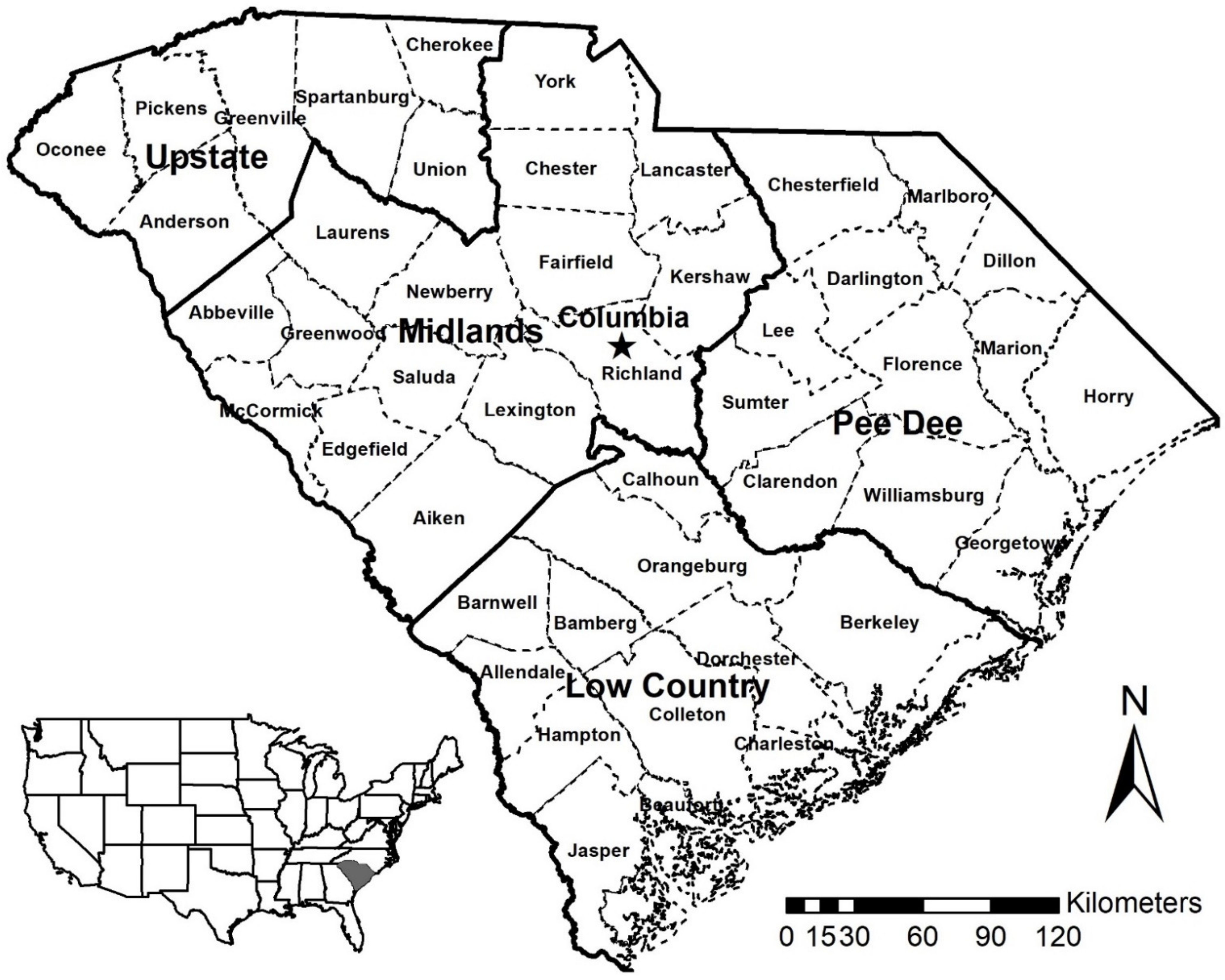
3.1. Storage and Value of SOC by County, Region, and Soil Order for the State of South Carolina (U.S.A.)
3.2. Storage and Value of SIC by County, Region, and Soil Order for the State of South Carolina (U.S.A.)
3.3. Storage and Value of TSC (SOC + SIC) by County, Region, and Soil Order for the State of South Carolina (U.S.A.)
4. Discussion
| Soil Regulating Ecosystem Services in the State of South Carolina | ||||||
|---|---|---|---|---|---|---|
| Slight <------------------- Degree of Weathering and Soil Development ----------------------> Strong | ||||||
| Slightly Weathered 18% | Moderately Weathered 9% | Strongly Weathered 72% | ||||
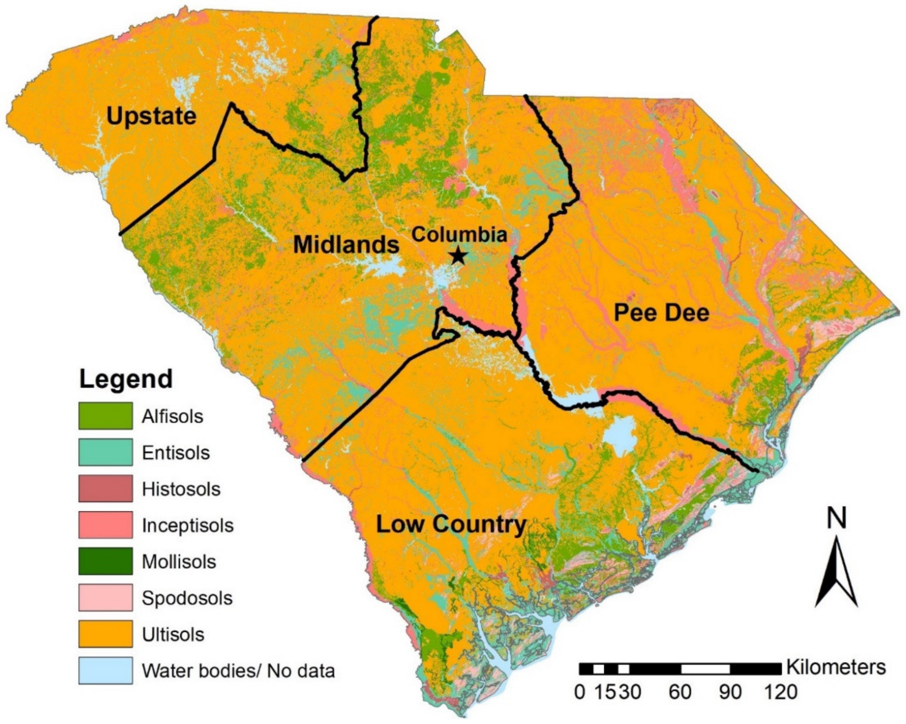
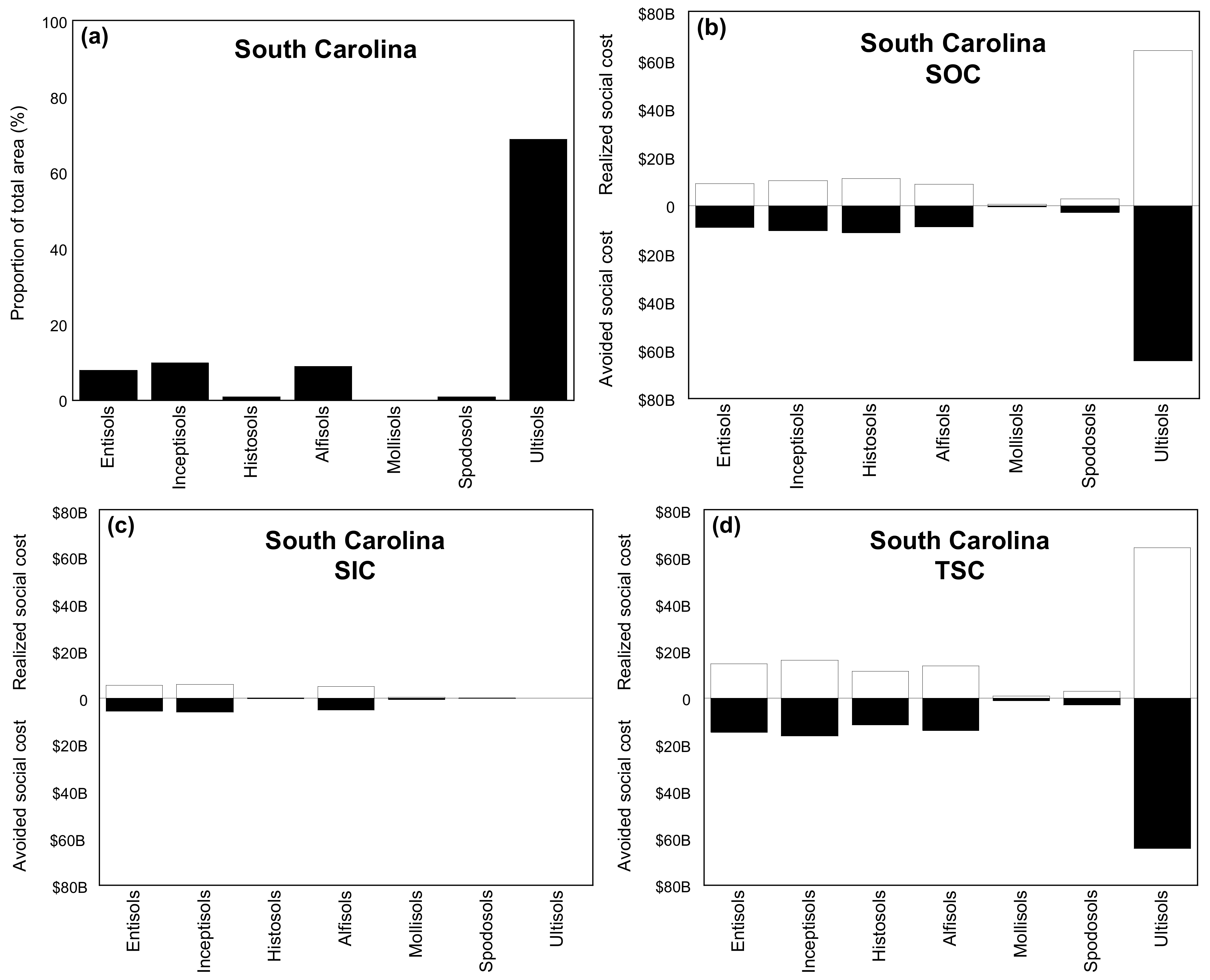
| Entisols 9% | Inceptisols 9% | Histosols 1% | Alfisols 9% | Mollisols 0% | Spodosols 2% | Ultisols 70% |
 |  |  |  |  |  |  |
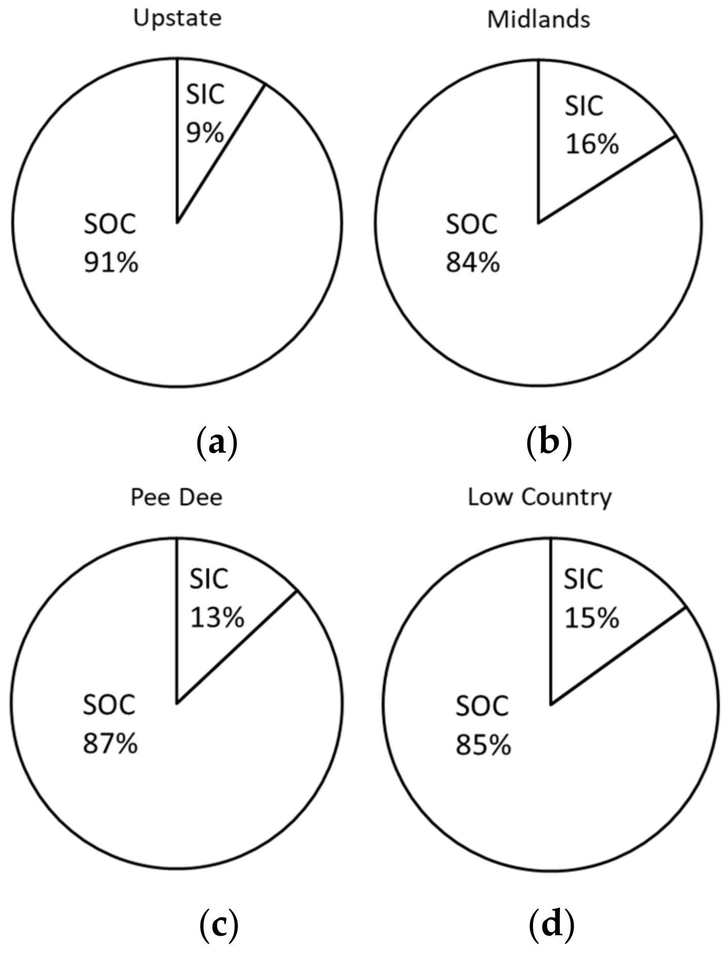
| The social cost of soil organic carbon (SOC) in USD: $107.14B | ||||||
| $9.11B | $10.30B | $11.20B | $8.82B | $524.00M | $2.82B | $64.30B |
| 9% | 10% | 10% | 8% | 0% | 3% | 60% |
| The social cost of soil inorganic carbon (SIC) in USD: $17.22B | ||||||
| $5.53B | $5.91B | $195.00M | $5.00B | $444.00M | $136.00M | $0 |
| 32% | 34% | 1% | 29% | 3% | 1% | 0% |
| The social cost of total soil carbon (TSC) in USD: $124.36B | ||||||
| $14.60B | $16.20B | $11.40B | $13.80B | $968.00M | $2.95B | $64.30B |
| 12% | 13% | 9% | 11% | 1% | 2% | 52% |
| Sensitivity to climate change | ||||||
| Low | Low | High | High | High | Low | Low |
| Soil organic and inorganic carbon sequestration (recarbonization) potential | ||||||
| Low | Low | Low | Low | Low | Low | Low |
5. Conclusions
Author Contributions
Funding
Data Availability Statement
Acknowledgments
Conflicts of Interest
Glossary
| ED | Ecosystem disservices |
| ES | Ecosystem services |
| EPA | Environmental Protection Agency |
| SC-CO2 | Social cost of carbon emissions |
| SDGs | Sustainable Development Goals |
| SOC | Soil organic carbon |
| SIC | Soil inorganic carbon |
| SOM | Soil organic matter |
| SSURGO | Soil Survey Geographic Database |
| TSC | Total soil carbon |
| USDA | United States Department of Agriculture |
| U.S.A. | United States of America |
References
- Keestra, S.D.; Bouma, J.; Wallinga, J.; Tittonell, P.; Smith, P.; Cerda, A.; Montanarella, L.; Quinton, J.N.; Pachepsky, Y.; Van der Putten, W.H.; et al. The significance of soils and soil science towards realization of the United Nations Sustainable Development Goals. Soil 2016, 2, 111–128. [Google Scholar] [CrossRef] [Green Version]
- Wood, S.L.; Jones, S.K.; Johnson, J.A.; Brauman, K.A.; Chaplin-Kramer, R.; Fremier, A.; Girvetz, E.; Gordon, L.J.; Kappel, C.V.; Mandle, L.; et al. Distilling the role of ecosystem services in the Sustainable Development Goals. Ecosyt. Serv. 2017, 29, 701–782. [Google Scholar] [CrossRef] [Green Version]
- Adhikari, K.; Hartemink, A.E. Linking soils to ecosystem services—A global review. Geoderma 2016, 262, 101–111. [Google Scholar] [CrossRef]
- Plaster, E.J. Soil Science and Management, 4th ed.; Delmar Learning, a Division of Thomson Learning, Inc.: Clifton Park, NY, USA, 2003; ISBN 0766839362. [Google Scholar]
- Mikhailova, E.A.; Post, C.J.; Schlautman, M.A.; Post, G.C.; Zurqani, H.A. The business side of ecosystem services of soil systems. Earth 2020, 1, 15–34. [Google Scholar] [CrossRef]
- Feller, C.; Manlay, R.J.; Swift, M.J.; Bernoux, M. Functions, services and value of soil organic matter for human societies and the environment: A historical perspective. In Functions of Soils for Human Societies and the Environment, 2nd ed.; Frossard, E., Blum, W.E.H., Warkentin, B.P., Eds.; Geological Society of London: London, UK, 2006; Volume 206, pp. 9–22. [Google Scholar]
- Sheikh, M.A.; Kumar, M.; Todaria, N.P.; Pandey, R. Biomass and soil carbon along altitudinal gradients in temperate Cedrus deodara forests in Central Himalaya, India: Implications for climate change mitigation. Ecol. Indic. 2020, 111, 106025. [Google Scholar] [CrossRef]
- Mikhailova, E.A.; Groshans, G.R.; Post, C.J.; Schlautman, M.A.; Post, G.C. Valuation of soil organic carbon stocks in the contiguous United States based on the avoided social cost of carbon emissions. Resources 2019, 8, 153. [Google Scholar] [CrossRef] [Green Version]
- Groshans, G.R.; Mikhailova, E.A.; Post, C.J.; Schlautman, M.A.; Zhang, L. Determining the value of soil inorganic carbon stocks in the contiguous United States based on the avoided social cost of carbon emissions. Resources 2019, 8, 119. [Google Scholar] [CrossRef] [Green Version]
- Mikhailova, E.A.; Post, C.J.; Schlautman, M.A.; Post, C.J.; Zurqani, H.A. Determining farm-scale site-specific monetary values of “soil carbon hotspots” based on avoided social costs of CO2 emissions. Cogent Environ. Sci. 2020, 6, 1–1817289. [Google Scholar] [CrossRef]
- Mikhailova, E.A.; Groshans, G.R.; Post, C.J.; Schlautman, M.A.; Post, C.J. Valuation of total soil carbon stocks in the contiguous United States based on the avoided social cost of carbon emissions. Resources 2019, 8, 157. [Google Scholar] [CrossRef] [Green Version]
- Lehmann, J.; Kleber, M. The contentious nature of soil organic matter. Nature 2015, 528, 60–68. [Google Scholar] [CrossRef] [PubMed]
- Heaton, L.; Fullen, M.A.; Bhattacharyya, R. Critical analysis of the van Bemmelen conversion factor used to convert soil organic matter data to soil organic carbon data: Comparative analyses in a UK loamy sand soil. Espaço Aberto 2016, 6, 35–44. [Google Scholar] [CrossRef]
- Mikhailova, E.A.; Goddard, M.A.; Post, C.J.; Schlautman, M.A.; Galbraith, J.M. Potential contribution of combined atmospheric Ca2+ and Mg2+ wet deposition within the continental U.S. to soil inorganic carbon sequestration. Pedosphere 2013, 23, 808–814. [Google Scholar] [CrossRef]
- Soil Survey Staff, Natural Resources Conservation Service, United States Department of Agriculture. Soil Survey Geographic (SSURGO) Database. Available online: https://nrcs.app.box.com/v/soils (accessed on 10 September 2020).
- Fossey, M.; Angers, D.; Bustany, C.; Cudennec, C.; Durand, P.; Gascuel-Odoux, C.; Jaffrezic, A.; Pérès, G.; Besse, C.; Walter, C. A framework to consider soil ecosystem services in territorial planning. Front. Environ. Sci. 2020, 8. Article 28. [Google Scholar] [CrossRef] [Green Version]
- EPA. The Social Cost of Carbon. EPA Fact Sheet. 2016. Available online: https://19january2017snapshot.epa.gov/climatechange/social-cost-carbon_.html (accessed on 15 March 2019).
- Guo, Y.; Amundson, R.; Gong, P.; Yu, Q. Quantity and spatial variability of soil carbon in the conterminous United States. Soil Sci. Soc. Am. J. 2006, 70, 590–600. [Google Scholar] [CrossRef] [Green Version]
- Groshans, G.R.; Mikhailova, E.A.; Post, C.J.; Schlautman, M.A. Accounting for soil inorganic carbon in the ecosystem services framework for the United Nations sustainable development goals. Geoderma 2018, 324, 37–46. [Google Scholar] [CrossRef] [Green Version]
- The United States Census Bureau, 2018 TIGER/Line Boundary Shapefiles. Available online: https://www.census.gov/geographies/mapping-files/time-series/geo/tiger-line-file.2018.html (accessed on 10 October 2020).
- Burt, R. Soil Survey Laboratory Methods Manual. Soil Survey Investigations Report No. 42 Version 3. U.S. Department of Agriculture, Natural Resources Conservation Service. 1996. Available online: https://www.nrcs.usda.gov/Internet/FSE_DOCUMENTS/nrcseprd1026806.pdf (accessed on 10 October 2020).
- Mikhailova, E.A.; Zurqani, H.A.; Post, C.J.; Schlautman, M.A.; Post, C.J. Soil diversity (pedodiversity) and ecosystem services. Land 2021, 10, 288. [Google Scholar] [CrossRef]
- Soil Survey Staff, Natural Resources Conservation Service, United States Department of Agriculture. Photos of soil orders. Available online: https://www.nrcs.usda.gov/wps/portal/nrcs/detail/soils/edu/?cid=nrcs142p2_053588 (accessed on 20 February 2021).
- Amelung, W.; Bossio, D.; de Vries, W.; Kögel-Knabner, I.; Lehmann, J.; Amundson, R.; Bol, R.; Collins, C.; Lal, R.; Leifeld, J.; et al. Towards a global-scale soil climate mitigation strategy. Nat. Commun. 2020, 11, 5427. [Google Scholar] [CrossRef] [PubMed]
- Galang, M.A.; Markewitz, D.; Morris, L.A.; Bussell, P. Land use change and gully erosion in the Piedmont region of South Carolina. J. Soil Water Conserv. 2007, 62, 122–129. [Google Scholar]
- Kroeger, T.; Casey, F. An assessment of market-based approaches to providing ecosystem services on agricultural lands. Ecol. Econ. 2007, 321–332. [Google Scholar] [CrossRef]
- Greainer, L.; Keller, A.; Grêt-Regamey, A.; Papritz, A. Soil function assessment: Review of methods for quantifying the contributions of soils to ecosystem services. Land Use Policy 2017, 69, 224–237. [Google Scholar] [CrossRef]


| County (Region) | Total Area (km2) (Rank) | Slight <------------------ Degree of Weathering and Soil Development -------------------------> Strong | ||||||
|---|---|---|---|---|---|---|---|---|
| Slightly Weathered | Moderately Weathered | Strongly Weathered | ||||||
| Entisols | Inceptisols | Histosols | Alfisols | Mollisols | Spodosols | Ultisols | ||
| Area (km2) | ||||||||
| Anderson | 1841 (14) | 102 | 0 | 0 | 0 | 0 | 0 | 1739 |
| Cherokee | 1012 (44) | 118 | 94 | 0 | 100 | 0 | 0 | 700 |
| Greenville | 1916 (11) | 108 | 166 | 0 | 0 | 0 | 0 | 1642 |
| Oconee | 1620 (23) | 37 | 56 | 0 | 0 | 0 | 0 | 1527 |
| Pickens | 1257 (35) | 39 | 55 | 0 | 0 | 0 | 0 | 1163 |
| Spartanburg | 1881 (12) | 8 | 161 | 0 | 77 | 0 | 0 | 1635 |
| Union | 1322 (32) | 74 | 61 | 0 | 364 | 0 | 0 | 823 |
| (Upstate) | 10,849 (4) | 486 | 593 | 0 | 541 | 0 | 0 | 9229 |
| Abbeville | 1269 (34) | 52 | 38 | 0 | 401 | 0 | 0 | 778 |
| Aiken | 2758 (4) | 445 | 213 | 11 | 5 | 0 | 0 | 2084 |
| Chester | 1493 (25) | 60 | 82 | 0 | 570 | 6 | 0 | 775 |
| Edgefield | 1289 (33) | 101 | 56 | 0 | 61 | 0 | 0 | 1071 |
| Fairfield | 1683 (20) | 1 | 175 | 0 | 585 | 0 | 0 | 922 |
| Greenwood | 1171 (38) | 0 | 116 | 0 | 335 | 0 | 0 | 720 |
| Kershaw | 1871 (13) | 383 | 161 | 20 | 47 | 0 | 0 | 1260 |
| Lancaster | 1409 (30) | 53 | 151 | 0 | 62 | 0 | 0 | 1143 |
| Laurens | 1837 (15) | 125 | 19 | 0 | 351 | 0 | 0 | 1342 |
| Lexington | 1756 (17) | 454 | 86 | 0 | 36 | 0 | 10 | 1170 |
| Newberry | 1621 (22) | 70 | 64 | 0 | 278 | 0 | 0 | 1209 |
| Richland | 1827 (16) | 163 | 360 | 8 | 19 | 0 | 0 | 1277 |
| Saluda | 1170 (39) | 19 | 83 | 0 | 77 | 0 | 0 | 991 |
| York | 1753 (18) | 5 | 134 | 0 | 577 | 0 | 0 | 1037 |
| (Midlands) | 22,899 (1) | 1931 | 1738 | 31 | 3404 | 6 | 10 | 15,779 |
| Chesterfield | 2053 (9) | 173 | 655 | 0 | 23 | 0 | 0 | 1202 |
| Clarendon | 1566 (24) | 39 | 192 | 6 | 0 | 0 | 0 | 1329 |
| Darlington | 1442 (28) | 36 | 258 | 9 | 0 | 0 | 1 | 1138 |
| Dillon | 1040 (42) | 91 | 128 | 8 | 0 | 0 | 19 | 794 |
| Florence | 2046 (10) | 97 | 224 | 0 | 0 | 0 | 2 | 1723 |
| Georgetown | 2064 (8) | 351 | 274 | 57 | 409 | 0 | 115 | 858 |
| Horry | 2888 (1) | 252 | 431 | 64 | 287 | 0 | 330 | 1524 |
| Lee | 1058 (40) | 29 | 131 | 0 | 1 | 0 | 0 | 897 |
| Marion | 1241 (36) | 107 | 286 | 27 | 0 | 0 | 49 | 772 |
| Marlboro | 1230 (37) | 75 | 269 | 81 | 17 | 0 | 2 | 786 |
| Sumter | 1694 (19) | 9 | 350 | 0 | 4 | 0 | 2 | 1329 |
| Williamsburg | 2400 (6) | 25 | 209 | 0 | 0 | 0 | 3 | 2163 |
| (Pee Dee) | 20,722 (3) | 1284 | 3407 | 252 | 741 | 0 | 523 | 14,515 |
| Allendale | 1055 (41) | 25 | 101 | 6 | 0 | 0 | 0 | 923 |
| Bamberg | 1018 (44) | 126 | 1 | 0 | 41 | 0 | 3 | 847 |
| Barnwell | 1416 (29) | 78 | 138 | 0 | 0 | 0 | 0 | 1200 |
| Beaufort | 1402 (31) | 698 | 34 | 6 | 40 | 23 | 210 | 391 |
| Berkeley | 2809 (3) | 145 | 208 | 23 | 409 | 0 | 137 | 1887 |
| Calhoun | 748 (46) | 66 | 26 | 0 | 0 | 0 | 0 | 656 |
| Charleston | 2317 (7) | 765 | 332 | 0 | 727 | 0 | 273 | 220 |
| Colleton | 2677 (5) | 280 | 49 | 88 | 140 | 85 | 109 | 1,926 |
| Dorchester | 1455 (26) | 274 | 17 | 1 | 280 | 0 | 30 | 853 |
| Hampton | 1443 (27) | 136 | 87 | 3 | 101 | 0 | 40 | 1076 |
| Jasper | 1669 (21) | 318 | 58 | 57 | 246 | 116 | 24 | 850 |
| McCormick | 921 (45) | 64 | 65 | 0 | 247 | 0 | 0 | 545 |
| Orangeburg | 2844 (2) | 73 | 18 | 0 | 25 | 0 | 1 | 2,727 |
| (Low Country) | 21,774 (2) | 3048 | 1134 | 184 | 2256 | 224 | 827 | 14,101 |
| Totals | 76,252 | 6749 | 6872 | 475 | 6942 | 230 | 1360 | 53,624 |
| Soil Order | SOC Content | SIC Content | TSC Content | SOC Value | SIC Value | TSC Value |
|---|---|---|---|---|---|---|
| Minimum–Midpoint–Maximum Values | Midpoint Values | |||||
| (kg m−2) | (kg m−2) | (kg m−2) | ($ m−2) | ($ m−2) | ($ m−2) | |
| Slightly Weathered | ||||||
| Entisols | 1.8–8.0–15.8 | 1.9–4.8–8.4 | 3.7–12.8–24.2 | 1.35 | 0.82 | 2.17 |
| Inceptisols | 2.8–8.9–17.4 | 2.5–5.1–8.4 | 5.3–14.0–25.8 | 1.50 | 0.86 | 2.36 |
| Histosols | 63.9–140.1–243.9 | 0.6–2.4–5.0 | 64.5–142.5–248.9 | 23.62 | 0.41 | 24.03 |
| Moderately Weathered | ||||||
| Alfisols | 2.3–7.5–14.1 | 1.3–4.3–8.1 | 3.6–11.8–22.2 | 1.27 | 0.72 | 1.99 |
| Mollisols | 5.9–13.5–22.8 | 4.9–11.5–19.7 | 10.8–25.0–42.5 | 2.28 | 1.93 | 4.21 |
| Strongly Weathered | ||||||
| Spodosols | 2.9–12.3–25.5 | 0.2–0.6–1.1 | 3.1–12.9–26.6 | 2.07 | 0.10 | 2.17 |
| Ultisols | 1.9–7.1–13.9 | 0.0–0.0–0.0 | 1.9–7.1–13.9 | 1.20 | 0.00 | 1.20 |
| County (Region) | Total Storage (kg) (Rank) | Slight <------------------- Degree of Weathering and Soil Development -------------------------> Strong | ||||||
|---|---|---|---|---|---|---|---|---|
| Slightly Weathered | Moderately Weathered | Strongly Weathered | ||||||
| Entisols | Inceptisols | Histosols | Alfisols | Mollisols | Spodosols | Ultisols | ||
| Total Storage (kg) | ||||||||
| Anderson | 1.32 × 10¹⁰ (19) | 8.16 × 10⁸ | 0 | 0 | 0 | 0 | 0 | 1.23 × 10¹⁰ |
| Cherokee | 7.50 × 10⁹ (43) | 9.44 × 10⁸ | 8.37 × 10⁸ | 0 | 7.50 × 10⁸ | 0 | 0 | 4.97 × 10⁹ |
| Greenville | 1.40 × 10¹⁰ (15) | 8.64 × 10⁸ | 1.48 × 10⁹ | 0 | 0 | 0 | 0 | 1.17 × 10¹⁰ |
| Oconee | 1.16 × 10¹⁰ (28) | 2.96 × 10⁸ | 4.98 × 10⁸ | 0 | 0 | 0 | 0 | 1.08 × 10¹⁰ |
| Pickens | 9.06 × 10⁹ (37) | 3.12 × 10⁸ | 4.90 × 10⁸ | 0 | 0 | 0 | 0 | 8.26 × 10⁹ |
| Spartanburg | 1.37 × 10¹⁰ (16) | 6.40 × 10⁷ | 1.43 × 10⁹ | 0 | 5.78 × 10⁸ | 0 | 0 | 1.16 × 10¹⁰ |
| Union | 9.71 × 10⁹ (34) | 5.92 × 10⁸ | 5.43 × 10⁸ | 0 | 2.73 × 10⁹ | 0 | 0 | 5.84 × 10⁹ |
| (Upstate) | 7.87× 10¹⁰ (4) | 3.89× 10⁹ | 5.28× 10⁹ | 0 | 4.06× 10⁹ | 0 | 0 | 6.55× 10¹⁰ |
| Abbeville | 9.29 × 10⁹ (36) | 4.16 × 10⁸ | 3.38 × 10⁸ | 0 | 3.01 × 10⁹ | 0 | 0 | 5.52 × 10⁹ |
| Aiken | 2.18 × 10¹⁰ (5) | 3.56 × 10⁹ | 1.90 × 10⁹ | 1.54 × 10⁹ | 3.75 × 10⁷ | 0 | 0 | 1.48 × 10¹⁰ |
| Chester | 1.11 × 10¹⁰ (30) | 4.80 × 10⁸ | 7.30 × 10⁸ | 0 | 4.28 × 10⁹ | 8.10 × 10⁷ | 0 | 5.50 × 10⁹ |
| Edgefield | 9.37 × 10⁹ (35) | 8.08 × 10⁸ | 4.98 × 10⁸ | 0 | 4.58 × 10⁸ | 0 | 0 | 7.60 × 10⁹ |
| Fairfield | 1.25 × 10¹⁰ (24) | 8.00 × 10⁶ | 1.56 × 10⁹ | 0 | 4.39 × 10⁹ | 0 | 0 | 6.55 × 10⁹ |
| Greenwood | 8.66 × 10⁹ (39) | 0 | 1.03 × 10⁹ | 0 | 2.51 × 10⁹ | 0 | 0 | 5.11 × 10⁹ |
| Kershaw | 1.66 × 10¹⁰ (11) | 3.06 × 10⁹ | 1.43 × 10⁹ | 2.80 × 10⁹ | 3.53 × 10⁸ | 0 | 0 | 8.95 × 10⁹ |
| Lancaster | 1.03 × 10¹⁰ (33) | 4.24 × 10⁸ | 1.34 × 10⁹ | 0 | 4.65 × 10⁸ | 0 | 0 | 8.12 × 10⁹ |
| Laurens | 1.33 × 10¹⁰ (17) | 1.00 × 10⁹ | 1.69 × 10⁸ | 0 | 2.63 × 10⁹ | 0 | 0 | 9.53 × 10⁹ |
| Lexington | 1.31 × 10¹⁰ (20) | 3.63 × 10⁹ | 7.65 × 10⁸ | 0 | 2.70 × 10⁸ | 0 | 1.23 × 10⁸ | 8.31 × 10⁹ |
| Newberry | 1.18 × 10¹⁰ (27) | 5.60 × 10⁸ | 5.70 × 10⁸ | 0 | 2.09 × 10⁹ | 0 | 0 | 8.58 × 10⁹ |
| Richland | 1.48 × 10¹⁰ (14) | 1.30 × 10⁹ | 3.20 × 10⁹ | 1.12 × 10⁹ | 1.43 × 10⁸ | 0 | 0 | 9.07 × 10⁹ |
| Saluda | 8.50 × 10⁹ (40) | 1.52 × 10⁸ | 7.39 × 10⁸ | 0 | 5.78 × 10⁸ | 0 | 0 | 7.04 × 10⁹ |
| York | 1.29 × 10¹⁰ (21) | 4.00 × 10⁷ | 1.19 × 10⁹ | 0 | 4.33 × 10⁹ | 0 | 0 | 7.36 × 10⁹ |
| (Midlands) | 1.73× 10¹¹ (3) | 1.54× 10¹⁰ | 1.55× 10¹⁰ | 4.34× 10⁹ | 2.55× 10¹⁰ | 8.10× 10⁷ | 1.23× 10⁸ | 1.12× 10¹¹ |
| Chesterfield | 1.59 × 10¹⁰ (12) | 1.38 × 10⁹ | 5.83 × 10⁹ | 0 | 1.73 × 10⁸ | 0 | 0 | 8.53 × 10⁹ |
| Clarendon | 1.23 × 10¹⁰ (25) | 3.12 × 10⁸ | 1.71 × 10⁹ | 8.41 × 10⁸ | 0 | 0 | 0 | 9.44 × 10⁹ |
| Darlington | 1.19 × 10¹⁰ (26) | 2.88 × 10⁸ | 2.30 × 10⁹ | 1.26 × 10⁹ | 0 | 0 | 1.23 × 10⁷ | 8.08 × 10⁹ |
| Dillon | 8.86 × 10⁹ (38) | 7.28 × 10⁸ | 1.14 × 10⁹ | 1.12 × 10⁹ | 0 | 0 | 2.34 × 10⁸ | 5.64 × 10⁹ |
| Florence | 1.50 × 10¹⁰ (13) | 7.76 × 10⁸ | 1.99 × 10⁹ | 0 | 0 | 0 | 2.46 × 10⁷ | 1.22 × 10¹⁰ |
| Georgetown | 2.38 × 10¹⁰ (4) | 2.81 × 10⁹ | 2.44 × 10⁹ | 7.99 × 10⁹ | 3.07 × 10⁹ | 0 | 1.41 × 10⁹ | 6.09 × 10⁹ |
| Horry | 3.19 × 10¹⁰ (2) | 2.02 × 10⁹ | 3.84 × 10⁹ | 8.97 × 10⁹ | 2.15 × 10⁹ | 0 | 4.06 × 10⁹ | 1.08 × 10¹⁰ |
| Lee | 7.77 × 10⁹ (42) | 2.32 × 10⁸ | 1.17 × 10⁹ | 0 | 7.50 × 10⁶ | 0 | 0 | 6.37 × 10⁹ |
| Marion | 1.33 × 10¹⁰ (18) | 8.56 × 10⁸ | 2.55 × 10⁹ | 3.78 × 10⁹ | 0 | 0 | 6.03 × 10⁸ | 5.48 × 10⁹ |
| Marlboro | 2.01 × 10¹⁰ (8) | 6.00 × 10⁸ | 2.39 × 10⁹ | 1.13 × 10¹⁰ | 1.28 × 10⁸ | 0 | 2.46 × 10⁷ | 5.58 × 10⁹ |
| Sumter | 1.27 × 10¹⁰ (23) | 7.20 × 10⁷ | 3.12 × 10⁹ | 0 | 3.00 × 10⁷ | 0 | 2.46 × 10⁷ | 9.44 × 10⁹ |
| Williamsburg | 1.75 × 10¹⁰ (10) | 2.00 × 10⁸ | 1.86 × 10⁹ | 0 | 0 | 0 | 3.69 × 10⁷ | 1.54 × 10¹⁰ |
| (Pee Dee) | 1.91× 10¹¹ (1) | 1.03× 10¹⁰ | 3.03× 10¹⁰ | 3.53× 10¹⁰ | 5.56× 10⁹ | 0 | 6.43× 10⁹ | 1.03× 10¹¹ |
| Allendale | 8.49 × 10⁹ (41) | 2.00 × 10⁸ | 8.99 × 10⁸ | 8.41 × 10⁸ | 0 | 0 | 0 | 6.55 × 10⁹ |
| Bamberg | 7.38 × 10⁹ (44) | 1.01 × 10⁹ | 8.90 × 10⁶ | 0 | 3.08 × 10⁸ | 0 | 3.69 × 10⁷ | 6.01 × 10⁹ |
| Barnwell | 1.04 × 10¹⁰ (32) | 6.24 × 10⁸ | 1.23 × 10⁹ | 0 | 0 | 0 | 0 | 8.52 × 10⁹ |
| Beaufort | 1.27 × 10¹⁰ (22) | 5.58 × 10⁹ | 3.03 × 10⁸ | 8.41 × 10⁸ | 3.00 × 10⁸ | 3.11 × 10⁸ | 2.58 × 10⁹ | 2.78 × 10⁹ |
| Berkeley | 2.44 × 10¹⁰ (3) | 1.16 × 10⁹ | 1.85 × 10⁹ | 3.22 × 10⁹ | 3.07 × 10⁹ | 0 | 1.69 × 10⁹ | 1.34 × 10¹⁰ |
| Calhoun | 5.42 × 10⁹ (46) | 5.28 × 10⁸ | 2.31 × 10⁸ | 0 | 0 | 0 | 0 | 4.66 × 10⁹ |
| Charleston | 1.94 × 10¹⁰ (9) | 6.12 × 10⁹ | 2.95 × 10⁹ | 0 | 5.45 × 10⁹ | 0 | 3.36 × 10⁹ | 1.56 × 10⁹ |
| Colleton | 3.22 × 10¹⁰ (1) | 2.24 × 10⁹ | 4.36 × 10⁸ | 1.23 × 10¹⁰ | 1.05 × 10⁹ | 1.15 × 10⁹ | 1.34 × 10⁹ | 1.37 × 10¹⁰ |
| Dorchester | 1.10 × 10¹⁰ (31) | 2.19 × 10⁹ | 1.51 × 10⁸ | 1.40 × 10⁸ | 2.10 × 10⁹ | 0 | 3.69 × 10⁸ | 6.06 × 10⁹ |
| Hampton | 1.12 × 10¹⁰ (29) | 1.09 × 10⁹ | 7.74 × 10⁸ | 4.20 × 10⁸ | 7.58 × 10⁸ | 0 | 4.92 × 10⁸ | 7.64 × 10⁹ |
| Jasper | 2.08 × 10¹⁰ (6) | 2.54 × 10⁹ | 5.16 × 10⁸ | 7.99 × 10⁹ | 1.85 × 10⁹ | 1.57 × 10⁹ | 2.95 × 10⁸ | 6.04 × 10⁹ |
| McCormick | 6.81 × 10⁹ (45) | 5.12 × 10⁸ | 5.79 × 10⁸ | 0 | 1.85 × 10⁹ | 0 | 0 | 3.87 × 10⁹ |
| Orangeburg | 2.03 × 10¹⁰ (7) | 5.84 × 10⁸ | 1.60 × 10⁸ | 0 | 1.88 × 10⁸ | 0 | 1.23 × 10⁷ | 1.94 × 10¹⁰ |
| (Low Country) | 1.90× 10¹¹ (2) | 2.44× 10¹⁰ | 1.01× 10¹⁰ | 2.58× 10¹⁰ | 1.69× 10¹⁰ | 3.02× 10⁹ | 1.02× 10¹⁰ | 1.00× 10¹¹ |
| Totals (kg) | 6.34× 10¹¹ | 5.40× 10¹⁰ | 6.12× 10¹⁰ | 6.65× 10¹⁰ | 5.21× 10¹⁰ | 3.11× 10⁹ | 1.67× 10¹⁰ | 3.81× 10¹¹ |
| County (Region) | Total Value ($) (Rank) | Slight <-------------------- Degree of Weathering and Soil Development -----------------------------> Strong | ||||||
|---|---|---|---|---|---|---|---|---|
| Slightly Weathered | Moderately Weathered | Strongly Weathered | ||||||
| Entisols | Inceptisols | Histosols | Alfisols | Mollisols | Spodosols | Ultisols | ||
| Value ($) | ||||||||
| Anderson | 2.22 × 10⁹ (19) | 1.38 × 10⁸ | 0 | 0 | 0 | 0 | 0 | 2.09 × 10⁹ |
| Cherokee | 1.27 × 10⁹ (43) | 1.59 × 10⁸ | 1.41 × 10⁸ | 0 | 1.27 × 10⁸ | 0 | 0 | 8.40 × 10⁸ |
| Greenville | 2.37 × 10⁹ (15) | 1.46 × 10⁸ | 2.49 × 10⁸ | 0 | 0 | 0 | 0 | 1.97 × 10⁹ |
| Oconee | 1.97 × 10⁹ (28) | 5.00 × 10⁷ | 8.40 × 10⁷ | 0 | 0 | 0 | 0 | 1.83 × 10⁹ |
| Pickens | 1.53 × 10⁹ (37) | 5.27 × 10⁷ | 8.25 × 10⁷ | 0 | 0 | 0 | 0 | 1.40 × 10⁹ |
| Spartanburg | 2.31 × 10⁹ (16) | 1.08 × 10⁷ | 2.42 × 10⁸ | 0 | 9.78 × 10⁷ | 0 | 0 | 1.96 × 10⁹ |
| Union | 1.64 × 10⁹ (34) | 9.99 × 10⁷ | 9.15 × 10⁷ | 0 | 4.62 × 10⁸ | 0 | 0 | 9.88 × 10⁸ |
| (Upstate) | 1.33 × 10¹⁰(4) | 6.56× 10⁸ | 8.90 × 10⁸ | 0 | 6.87× 10⁸ | 0 | 0 | 1.11 × 10¹⁰ |
| Abbeville | 1.57 × 10⁹ (36) | 7.02 × 10⁷ | 5.70 × 10⁷ | 0 | 5.09 × 10⁸ | 0 | 0 | 9.34 × 10⁸ |
| Aiken | 3.69 × 10⁹ (5) | 6.01 × 10⁸ | 3.20 × 10⁸ | 2.60 × 10⁸ | 6.35 × 10⁶ | 0 | 0 | 2.50 × 10⁹ |
| Chester | 1.87 × 10⁹ (30) | 8.10 × 10⁷ | 1.23 × 10⁸ | 0 | 7.24 × 10⁸ | 1.37 × 10⁷ | 0 | 9.30 × 10⁸ |
| Edgefield | 1.58 × 10⁹ (35) | 1.36 × 10⁸ | 8.40 × 10⁷ | 0 | 7.75 × 10⁷ | 0 | 0 | 1.29 × 10⁹ |
| Fairfield | 2.11 × 10⁹ (24) | 1.35 × 10⁶ | 2.63 × 10⁸ | 0 | 7.43 × 10⁸ | 0 | 0 | 1.11 × 10⁹ |
| Greenwood | 1.46 × 10⁹ (39) | 0 | 1.74 × 10⁸ | 0 | 4.25 × 10⁸ | 0 | 0 | 8.64 × 10⁸ |
| Kershaw | 2.80 × 10⁹ (11) | 5.17 × 10⁸ | 2.42 × 10⁸ | 4.72 × 10⁸ | 5.97 × 10⁷ | 0 | 0 | 1.51 × 10⁹ |
| Lancaster | 1.75 × 10⁹ (33) | 7.16 × 10⁷ | 2.27 × 10⁸ | 0 | 7.87 × 10⁷ | 0 | 0 | 1.37 × 10⁹ |
| Laurens | 2.25 × 10⁹ (17) | 1.69 × 10⁸ | 2.85 × 10⁷ | 0 | 4.46 × 10⁸ | 0 | 0 | 1.61 × 10⁹ |
| Lexington | 2.21 × 10⁹ (20) | 6.13 × 10⁸ | 1.29 × 10⁸ | 0 | 4.57 × 10⁷ | 0 | 2.07 × 10⁷ | 1.40 × 10⁹ |
| Newberry | 1.99 × 10⁹ (27) | 9.45 × 10⁷ | 9.60 × 10⁷ | 0 | 3.53 × 10⁸ | 0 | 0 | 1.45 × 10⁹ |
| Richland | 2.51 × 10⁹ (14) | 2.20 × 10⁸ | 5.40 × 10⁸ | 1.89 × 10⁸ | 2.41 × 10⁷ | 0 | 0 | 1.53 × 10⁹ |
| Saluda | 1.44 × 10⁹ (40) | 2.57 × 10⁷ | 1.25 × 10⁸ | 0 | 9.78 × 10⁷ | 0 | 0 | 1.19 × 10⁹ |
| York | 2.18 × 10⁹ (21) | 6.75 × 10⁶ | 2.01 × 10⁸ | 0 | 7.33 × 10⁸ | 0 | 0 | 1.24 × 10⁹ |
| (Midlands) | 2.92 × 10¹⁰(3) | 2.61× 10⁹ | 2.61 × 10⁹ | 7.32 × 10⁸ | 4.32× 10⁹ | 1.37× 10⁷ | 2.07× 10⁷ | 1.89 × 10¹⁰ |
| Chesterfield | 2.69 × 10⁹ (12) | 2.34 × 10⁸ | 9.83 × 10⁸ | 0 | 2.92 × 10⁷ | 0 | 0 | 1.44 × 10⁹ |
| Clarendon | 2.08 × 10⁹ (25) | 5.27 × 10⁷ | 2.88 × 10⁸ | 1.42 × 10⁸ | 0 | 0 | 0 | 1.59 × 10⁹ |
| Darlington | 2.02 × 10⁹ (26) | 4.86 × 10⁷ | 3.87 × 10⁸ | 2.13 × 10⁸ | 0 | 0 | 2.07 × 10⁶ | 1.37 × 10⁹ |
| Dillon | 1.50 × 10⁹ (38) | 1.23 × 10⁸ | 1.92 × 10⁸ | 1.89 × 10⁸ | 0 | 0 | 3.93 × 10⁷ | 9.53 × 10⁸ |
| Florence | 2.54 × 10⁹ (13) | 1.31 × 10⁸ | 3.36 × 10⁸ | 0 | 0 | 0 | 4.14 × 10⁶ | 2.07 × 10⁹ |
| Georgetown | 4.02 × 10⁹ (4) | 4.74 × 10⁸ | 4.11 × 10⁸ | 1.35 × 10⁹ | 5.19 × 10⁸ | 0 | 2.38 × 10⁸ | 1.03 × 10⁹ |
| Horry | 5.37 × 10⁹ (2) | 3.40 × 10⁸ | 6.47 × 10⁸ | 1.51 × 10⁹ | 3.64 × 10⁸ | 0 | 6.83 × 10⁸ | 1.83 × 10⁹ |
| Lee | 1.31 × 10⁹ (42) | 3.92 × 10⁷ | 1.97 × 10⁸ | 0 | 1.27 × 10⁶ | 0 | 0 | 1.08 × 10⁹ |
| Marion | 2.24 × 10⁹ (18) | 1.44 × 10⁸ | 4.29 × 10⁸ | 6.38 × 10⁸ | 0 | 0 | 1.01 × 10⁸ | 9.26 × 10⁸ |
| Marlboro | 3.39 × 10⁹ (8) | 1.01 × 10⁸ | 4.04 × 10⁸ | 1.91 × 10⁹ | 2.16 × 10⁷ | 0 | 4.14 × 10⁶ | 9.43 × 10⁸ |
| Sumter | 2.14 × 10⁹ (23) | 1.22 × 10⁷ | 5.25 × 10⁸ | 0 | 5.08 × 10⁶ | 0 | 4.14 × 10⁶ | 1.59 × 10⁹ |
| Williamsburg | 2.95 × 10⁹ (10) | 3.38 × 10⁷ | 3.14 × 10⁸ | 0 | 0 | 0 | 6.21 × 10⁶ | 2.60 × 10⁹ |
| (Pee Dee) | 3.22 × 10¹⁰(1) | 1.73× 10⁹ | 5.11 × 10⁹ | 5.95 × 10⁹ | 9.41× 10⁸ | 0 | 1.08× 10⁹ | 1.74 × 10¹⁰ |
| Allendale | 1.43 × 10⁹ (41) | 3.38 × 10⁷ | 1.52 × 10⁸ | 1.42 × 10⁸ | 0 | 0 | 0 | 1.11 × 10⁹ |
| Bamberg | 1.25 × 10⁹ (44) | 1.70 × 10⁸ | 1.50 × 10⁶ | 0 | 5.21 × 10⁷ | 0 | 6.21 × 10⁶ | 1.02 × 10⁹ |
| Barnwell | 1.75 × 10⁹ (32) | 1.05 × 10⁸ | 2.07 × 10⁸ | 0 | 0 | 0 | 0 | 1.44 × 10⁹ |
| Beaufort | 2.14 × 10⁹ (22) | 9.42 × 10⁸ | 5.10 × 10⁷ | 1.42 × 10⁸ | 5.08 × 10⁷ | 5.24 × 10⁷ | 4.35 × 10⁸ | 4.69 × 10⁸ |
| Berkeley | 4.12 × 10⁹ (3) | 1.96 × 10⁸ | 3.12 × 10⁸ | 5.43 × 10⁸ | 5.19 × 10⁸ | 0 | 2.84 × 10⁸ | 2.26 × 10⁹ |
| Calhoun | 9.15 × 10⁸ (46) | 8.91 × 10⁷ | 3.90 × 10⁷ | 0 | 0 | 0 | 0 | 7.87 × 10⁸ |
| Charleston | 3.28 × 10⁹ (9) | 1.03 × 10⁹ | 4.98 × 10⁸ | 0 | 9.23 × 10⁸ | 0 | 5.65 × 10⁸ | 2.64 × 10⁸ |
| Colleton | 5.44 × 10⁹ (1) | 3.78 × 10⁸ | 7.35 × 10⁷ | 2.08 × 10⁹ | 1.78 × 10⁸ | 1.94 × 10⁸ | 2.26 × 10⁸ | 2.31 × 10⁹ |
| Dorchester | 1.86 × 10⁹ (31) | 3.70 × 10⁸ | 2.55 × 10⁷ | 2.36 × 10⁷ | 3.56 × 10⁸ | 0 | 6.21 × 10⁷ | 1.02 × 10⁹ |
| Hampton | 1.89 × 10⁹ (29) | 1.84 × 10⁸ | 1.31 × 10⁸ | 7.09 × 10⁷ | 1.28 × 10⁸ | 0 | 8.28 × 10⁷ | 1.29 × 10⁹ |
| Jasper | 3.51 × 10⁹ (6) | 4.29 × 10⁸ | 8.70 × 10⁷ | 1.35 × 10⁹ | 3.12 × 10⁸ | 2.64 × 10⁸ | 4.97 × 10⁷ | 1.02 × 10⁹ |
| McCormick | 1.15 × 10⁹ (45) | 8.64 × 10⁷ | 9.75 × 10⁷ | 0 | 3.14 × 10⁸ | 0 | 0 | 6.54 × 10⁸ |
| Orangeburg | 3.43 × 10⁹ (7) | 9.86 × 10⁷ | 2.70 × 10⁷ | 0 | 3.18 × 10⁷ | 0 | 2.07 × 10⁶ | 3.27 × 10⁹ |
| (Low Country) | 3.22 × 10¹⁰(2) | 4.11× 10⁹ | 1.70 × 10⁹ | 4.35 × 10⁹ | 2.87× 10⁹ | 5.11× 10⁸ | 1.71× 10⁹ | 1.69 × 10¹⁰ |
| Totals ($) | 1.07 × 10¹¹ | 9.11× 10⁹ | 1.03 × 10¹⁰ | 1.12 × 10¹⁰ | 8.82× 10⁹ | 5.24× 10⁸ | 2.82× 10⁹ | 6.43 × 10¹⁰ |
| County (Region) | Total Storage (kg) (Rank) | Slight <------------------- Degree of Weathering and Soil Development --------------------------> Strong | ||||||
|---|---|---|---|---|---|---|---|---|
| Slightly Weathered | Moderately Weathered | Strongly Weathered | ||||||
| Entisols | Inceptisols | Histosols | Alfisols | Mollisols | Spodosols | Ultisols | ||
| Total Storage (kg) | ||||||||
| Anderson | 4.90 × 10⁸ (43) | 4.90 × 10⁸ | 0 | 0 | 0 | 0 | 0 | 0 |
| Cherokee | 1.48 × 10⁹ (29) | 5.66 × 10⁸ | 4.79 × 10⁸ | 0 | 4.30 × 10⁸ | 0 | 0 | 0 |
| Greenville | 1.37 × 10⁹ (30) | 5.18 × 10⁸ | 8.47 × 10⁸ | 0 | 0 | 0 | 0 | 0 |
| Oconee | 4.63 × 10⁸ (45) | 1.78 × 10⁸ | 2.86 × 10⁸ | 0 | 0 | 0 | 0 | 0 |
| Pickens | 4.68 × 10⁸ (44) | 1.87 × 10⁸ | 2.81 × 10⁸ | 0 | 0 | 0 | 0 | 0 |
| Spartanburg | 1.19 × 10⁹ (32) | 3.84 × 10⁷ | 8.21 × 10⁸ | 0 | 3.31 × 10⁸ | 0 | 0 | 0 |
| Union | 2.23 × 10⁹ (17) | 3.55 × 10⁸ | 3.11 × 10⁸ | 0 | 1.57 × 10⁹ | 0 | 0 | 0 |
| (Upstate) | 7.68× 10⁹ (4) | 2.33× 10⁹ | 3.02× 10⁹ | 0 | 2.33× 10⁹ | 0 | 0 | 0 |
| Abbeville | 2.17 × 10⁹ (19) | 2.50 × 10⁸ | 1.94 × 10⁸ | 0 | 1.72 × 10⁹ | 0 | 0 | 0 |
| Aiken | 3.27 × 10⁹ (10) | 2.14 × 10⁹ | 1.09 × 10⁹ | 2.64 × 10⁷ | 2.15 × 10⁷ | 0 | 0 | 0 |
| Chester | 3.23 × 10⁹ (11) | 2.88 × 10⁸ | 4.18 × 10⁸ | 0 | 2.45 × 10⁹ | 6.90 × 10⁷ | 0 | 0 |
| Edgefield | 1.03 × 10⁹ (37) | 4.85 × 10⁸ | 2.86 × 10⁸ | 0 | 2.62 × 10⁸ | 0 | 0 | 0 |
| Fairfield | 3.41 × 10⁹ (9) | 4.80 × 10⁶ | 8.93 × 10⁸ | 0 | 2.52 × 10⁹ | 0 | 0 | 0 |
| Greenwood | 2.03 × 10⁹ (21) | 0 | 5.92 × 10⁸ | 0 | 1.44 × 10⁹ | 0 | 0 | 0 |
| Kershaw | 2.91 × 10⁹ (13) | 1.84 × 10⁹ | 8.21 × 10⁸ | 4.80 × 10⁷ | 2.02 × 10⁸ | 0 | 0 | 0 |
| Lancaster | 1.29 × 10⁹ (31) | 2.54 × 10⁸ | 7.70 × 10⁸ | 0 | 2.67 × 10⁸ | 0 | 0 | 0 |
| Laurens | 2.21 × 10⁹ (18) | 6.00 × 10⁸ | 9.69 × 10⁷ | 0 | 1.51 × 10⁹ | 0 | 0 | 0 |
| Lexington | 2.78 × 10⁹ (14) | 2.18 × 10⁹ | 4.39 × 10⁸ | 0 | 1.55 × 10⁸ | 0 | 6.00 × 10⁶ | 0 |
| Newberry | 1.86 × 10⁹ (23) | 3.36 × 10⁸ | 3.26 × 10⁸ | 0 | 1.20 × 10⁹ | 0 | 0 | 0 |
| Richland | 2.72 × 10⁹ (15) | 7.82 × 10⁸ | 1.84 × 10⁹ | 1.92 × 10⁷ | 8.17 × 10⁷ | 0 | 0 | 0 |
| Saluda | 8.46 × 10⁸ (38) | 9.12 × 10⁷ | 4.23 × 10⁸ | 0 | 3.31 × 10⁸ | 0 | 0 | 0 |
| York | 3.19 × 10⁹ (12) | 2.40 × 10⁷ | 6.83 × 10⁸ | 0 | 2.48 × 10⁹ | 0 | 0 | 0 |
| (Midlands) | 3.29× 10¹⁰ (2) | 9.27× 10⁹ | 8.86× 10⁹ | 7.44× 10⁷ | 1.46× 10¹⁰ | 6.90× 10⁷ | 6.00× 10⁶ | 0 |
| Chesterfield | 4.27 × 10⁹ (5) | 8.30 × 10⁸ | 3.34 × 10⁹ | 0 | 9.89 × 10⁷ | 0 | 0 | 0 |
| Clarendon | 1.18 × 10⁹ (34) | 1.87 × 10⁸ | 9.79 × 10⁸ | 1.44 × 10⁷ | 0 | 0 | 0 | 0 |
| Darlington | 1.51 × 10⁹ (28) | 1.73 × 10⁸ | 1.32 × 10⁹ | 2.16 × 10⁷ | 0 | 0 | 6.00 × 10⁵ | 0 |
| Dillon | 1.12 × 10⁹ (35) | 4.37 × 10⁸ | 6.53 × 10⁸ | 1.92 × 10⁷ | 0 | 0 | 1.14 × 10⁷ | 0 |
| Florence | 1.61 × 10⁹ (26) | 4.66 × 10⁸ | 1.14 × 10⁹ | 0 | 0 | 0 | 1.20 × 10⁶ | 0 |
| Georgetown | 5.05 × 10⁹ (2) | 1.68 × 10⁹ | 1.40 × 10⁹ | 1.37 × 10⁸ | 1.76 × 10⁹ | 0 | 6.90 × 10⁷ | 0 |
| Horry | 4.99 × 10⁹ (3) | 1.21 × 10⁹ | 2.20 × 10⁹ | 1.54 × 10⁸ | 1.23 × 10⁹ | 0 | 1.98 × 10⁸ | 0 |
| Lee | 8.12 × 10⁸ (39) | 1.39 × 10⁸ | 6.68 × 10⁸ | 0 | 4.30 × 10⁶ | 0 | 0 | 0 |
| Marion | 2.07 × 10⁹ (20) | 5.14 × 10⁸ | 1.46 × 10⁹ | 6.48 × 10⁷ | 0 | 0 | 2.94 × 10⁷ | 0 |
| Marlboro | 2.00 × 10⁹ (22) | 3.60 × 10⁸ | 1.37 × 10⁹ | 1.94 × 10⁸ | 7.31 × 10⁷ | 0 | 1.20 × 10⁶ | 0 |
| Sumter | 1.85 × 10⁹ (24) | 4.32 × 10⁷ | 1.79 × 10⁹ | 0 | 1.72 × 10⁷ | 0 | 1.20 × 10⁶ | 0 |
| Williamsburg | 1.19 × 10⁹ (33) | 1.20 × 10⁸ | 1.07 × 10⁹ | 0 | 0 | 0 | 1.80 × 10⁶ | 0 |
| (Pee Dee) | 2.76× 10¹⁰ (3) | 6.16× 10⁹ | 1.74× 10¹⁰ | 6.05× 10⁸ | 3.19× 10⁹ | 0 | 3.14× 10⁸ | 0 |
| Allendale | 6.50 × 10⁸ (41) | 1.20 × 10⁸ | 5.15 × 10⁸ | 1.44 × 10⁷ | 0 | 0 | 0 | 0 |
| Bamberg | 7.88 × 10⁸ (40) | 6.05 × 10⁸ | 5.10 × 10⁶ | 0 | 1.76 × 10⁸ | 0 | 1.80 × 10⁶ | 0 |
| Barnwell | 1.08 × 10⁹ (36) | 3.74 × 10⁸ | 7.04 × 10⁸ | 0 | 0 | 0 | 0 | 0 |
| Beaufort | 4.10 × 10⁹ (6) | 3.35 × 10⁹ | 1.73 × 10⁸ | 1.44 × 10⁷ | 1.72 × 10⁸ | 2.65 × 10⁸ | 1.26 × 10⁸ | 0 |
| Berkeley | 3.65 × 10⁹ (7) | 6.96 × 10⁸ | 1.06 × 10⁹ | 5.52 × 10⁷ | 1.76 × 10⁹ | 0 | 8.22 × 10⁷ | 0 |
| Calhoun | 4.49 × 10⁸ (46) | 3.17 × 10⁸ | 1.33 × 10⁸ | 0 | 0 | 0 | 0 | 0 |
| Charleston | 8.66 × 10⁹ (1) | 3.67 × 10⁹ | 1.69 × 10⁹ | 0 | 3.13 × 10⁹ | 0 | 1.64 × 10⁸ | 0 |
| Colleton | 3.45 × 10⁹ (8) | 1.34 × 10⁹ | 2.50 × 10⁸ | 2.11 × 10⁸ | 6.02 × 10⁸ | 9.78 × 10⁸ | 6.54 × 10⁷ | 0 |
| Dorchester | 2.63 × 10⁹ (16) | 1.32 × 10⁹ | 8.67 × 10⁷ | 2.40 × 10⁶ | 1.20 × 10⁹ | 0 | 1.80 × 10⁷ | 0 |
| Hampton | 1.56 × 10⁹ (27) | 6.53 × 10⁸ | 4.44 × 10⁸ | 7.20 × 10⁶ | 4.34 × 10⁸ | 0 | 2.40 × 10⁷ | 0 |
| Jasper | 4.37 × 10⁹ (4) | 1.53 × 10⁹ | 2.96 × 10⁸ | 1.37 × 10⁸ | 1.06 × 10⁹ | 1.33 × 10⁹ | 1.44 × 10⁷ | 0 |
| McCormick | 1.70 × 10⁹ (25) | 3.07 × 10⁸ | 3.32 × 10⁸ | 0 | 1.06 × 10⁹ | 0 | 0 | 0 |
| Orangeburg | 5.50 × 10⁸ (42) | 3.50 × 10⁸ | 9.18 × 10⁷ | 0 | 1.08 × 10⁸ | 0 | 6.00 × 10⁵ | 0 |
| (Low Country) | 3.36× 10¹⁰ (1) | 1.46× 10¹⁰ | 5.78× 10⁹ | 4.42× 10⁸ | 9.70× 10⁹ | 2.58× 10⁹ | 4.96× 10⁸ | 0 |
| Totals (kg) | 1.02× 10¹¹ | 3.24× 10¹⁰ | 3.50× 10¹⁰ | 1.14× 10⁹ | 2.99× 10¹⁰ | 2.65× 10⁹ | 8.16× 10⁸ | 0 |
| County (Region) | Total Value ($) (Rank) | Slight <----------------- Degree of Weathering and Soil Development -------------------------> Strong | ||||||
|---|---|---|---|---|---|---|---|---|
| Slightly Weathered | Moderately Weathered | Strongly Weathered | ||||||
| Entisols | Inceptisols | Histosols | Alfisols | Mollisols | Spodosols | Ultisols | ||
| Value ($) | ||||||||
| Anderson | 8.36 × 10⁷ (43) | 8.36 × 10⁷ | 0 | 0 | 0 | 0 | 0 | 0 |
| Cherokee | 2.50 × 10⁸ (29) | 9.68 × 10⁷ | 8.08 × 10⁷ | 0 | 7.20 × 10⁷ | 0 | 0 | 0 |
| Greenville | 2.31 × 10⁸ (30) | 8.86 × 10⁷ | 1.43 × 10⁸ | 0 | 0 | 0 | 0 | 0 |
| Oconee | 7.85 × 10⁷ (45) | 3.03 × 10⁷ | 4.82 × 10⁷ | 0 | 0 | 0 | 0 | 0 |
| Pickens | 7.93 × 10⁷ (44) | 3.20 × 10⁷ | 4.73 × 10⁷ | 0 | 0 | 0 | 0 | 0 |
| Spartanburg | 2.00 × 10⁸ (32) | 6.56 × 10⁶ | 1.38 × 10⁸ | 0 | 5.54 × 10⁷ | 0 | 0 | 0 |
| Union | 3.75 × 10⁸ (17) | 6.07 × 10⁷ | 5.25 × 10⁷ | 0 | 2.62 × 10⁸ | 0 | 0 | 0 |
| (Upstate) | 1.30× 10⁹(4) | 3.99× 10⁸ | 5.10× 10⁸ | 0 | 3.90× 10⁸ | 0 | 0 | 0 |
| Abbeville | 3.64 × 10⁸ (19) | 4.26 × 10⁷ | 3.27 × 10⁷ | 0 | 2.89 × 10⁸ | 0 | 0 | 0 |
| Aiken | 5.56 × 10⁸ (10) | 3.65 × 10⁸ | 1.83 × 10⁸ | 4.51 × 10⁶ | 3.60 × 10⁶ | 0 | 0 | 0 |
| Chester | 5.42 × 10⁸ (11) | 4.92 × 10⁷ | 7.05 × 10⁷ | 0 | 4.10 × 10⁸ | 1.16 × 10⁷ | 0 | 0 |
| Edgefield | 1.75 × 10⁸ (37) | 8.28 × 10⁷ | 4.82 × 10⁷ | 0 | 4.39 × 10⁷ | 0 | 0 | 0 |
| Fairfield | 5.73 × 10⁸ (9) | 8.20 × 10⁵ | 1.51 × 10⁸ | 0 | 4.21 × 10⁸ | 0 | 0 | 0 |
| Greenwood | 3.41 × 10⁸ (21) | 0 | 9.98 × 10⁷ | 0 | 2.41 × 10⁸ | 0 | 0 | 0 |
| Kershaw | 4.95 × 10⁸ (13) | 3.14 × 10⁸ | 1.38 × 10⁸ | 8.20 × 10⁶ | 3.38 × 10⁷ | 0 | 0 | 0 |
| Lancaster | 2.18 × 10⁸ (31) | 4.35 × 10⁷ | 1.30 × 10⁸ | 0 | 4.46 × 10⁷ | 0 | 0 | 0 |
| Laurens | 3.72 × 10⁸ (18) | 1.03 × 10⁸ | 1.63 × 10⁷ | 0 | 2.53 × 10⁸ | 0 | 0 | 0 |
| Lexington | 4.73 × 10⁸ (14) | 3.72 × 10⁸ | 7.40 × 10⁷ | 0 | 2.59 × 10⁷ | 0 | 1.00 × 10⁶ | 0 |
| Newberry | 3.13 × 10⁸ (23) | 5.74 × 10⁷ | 5.50 × 10⁷ | 0 | 2.00 × 10⁸ | 0 | 0 | 0 |
| Richland | 4.60 × 10⁸ (15) | 1.34 × 10⁸ | 3.10 × 10⁸ | 3.28 × 10⁶ | 1.37 × 10⁷ | 0 | 0 | 0 |
| Saluda | 1.42 × 10⁸ (38) | 1.56 × 10⁷ | 7.14 × 10⁷ | 0 | 5.54 × 10⁷ | 0 | 0 | 0 |
| York | 5.35 × 10⁸ (12) | 4.10 × 10⁶ | 1.15 × 10⁸ | 0 | 4.15 × 10⁸ | 0 | 0 | 0 |
| (Midlands) | 5.55× 10⁹(2) | 1.58× 10⁹ | 1.49× 10⁹ | 1.27× 10⁷ | 2.45× 10⁹ | 1.16 × 10⁷ | 1.00 × 10⁶ | 0 |
| Chesterfield | 7.22 × 10⁸ (5) | 1.42 × 10⁸ | 5.63 × 10⁸ | 0 | 1.66 × 10⁷ | 0 | 0 | 0 |
| Clarendon | 2.00 × 10⁸ (34) | 3.20 × 10⁷ | 1.65 × 10⁸ | 2.46 × 10⁶ | 0 | 0 | 0 | 0 |
| Darlington | 2.55 × 10⁸ (28) | 2.95 × 10⁷ | 2.22 × 10⁸ | 3.69 × 10⁶ | 0 | 0 | 1.00 × 10⁵ | 0 |
| Dillon | 1.90 × 10⁸ (35) | 7.46 × 10⁷ | 1.10 × 10⁸ | 3.28 × 10⁶ | 0 | 0 | 1.90 × 10⁶ | 0 |
| Florence | 2.72 × 10⁸ (26) | 7.95 × 10⁷ | 1.93 × 10⁸ | 0 | 0 | 0 | 2.00 × 10⁵ | 0 |
| Georgetown | 8.53 × 10⁸ (2) | 2.88 × 10⁸ | 2.36 × 10⁸ | 2.34 × 10⁷ | 2.94 × 10⁸ | 0 | 1.15 × 10⁷ | 0 |
| Horry | 8.43 × 10⁸ (3) | 2.07 × 10⁸ | 3.71 × 10⁸ | 2.62 × 10⁷ | 2.07 × 10⁸ | 0 | 3.30 × 10⁷ | 0 |
| Lee | 1.37 × 10⁸ (39) | 2.38 × 10⁷ | 1.13 × 10⁸ | 0 | 7.20 × 10⁵ | 0 | 0 | 0 |
| Marion | 3.50 × 10⁸ (20) | 8.77 × 10⁷ | 2.46 × 10⁸ | 1.11 × 10⁷ | 0 | 0 | 4.90 × 10⁶ | 0 |
| Marlboro | 3.38 × 10⁸ (22) | 6.15 × 10⁷ | 2.31 × 10⁸ | 3.32 × 10⁷ | 1.22 × 10⁷ | 0 | 2.00 × 10⁵ | 0 |
| Sumter | 3.11 × 10⁸ (24) | 7.38 × 10⁶ | 3.01 × 10⁸ | 0 | 2.88 × 10⁶ | 0 | 2.00 × 10⁵ | 0 |
| Williamsburg | 2.01 × 10⁸ (33) | 2.05 × 10⁷ | 1.80 × 10⁸ | 0 | 0 | 0 | 3.00 × 10⁵ | 0 |
| (Pee Dee) | 4.67 × 10⁹(3) | 1.05× 10⁹ | 2.93× 10⁹ | 1.03× 10⁸ | 5.34× 10⁸ | 0 | 5.23 × 10⁷ | 0 |
| Allendale | 1.10 × 10⁸ (41) | 2.05 × 10⁷ | 8.69 × 10⁷ | 2.46 × 10⁶ | 0 | 0 | 0 | 0 |
| Bamberg | 1.34 × 10⁸ (40) | 1.03 × 10⁸ | 8.60 × 10⁵ | 0 | 2.95 × 10⁷ | 0 | 3.00 × 10⁵ | 0 |
| Barnwell | 1.83 × 10⁸ (36) | 6.40 × 10⁷ | 1.19 × 10⁸ | 0 | 0 | 0 | 0 | 0 |
| Beaufort | 6.98 × 10⁸ (6) | 5.72 × 10⁸ | 2.92 × 10⁷ | 2.46 × 10⁶ | 2.88 × 10⁷ | 4.44 × 10⁷ | 2.10 × 10⁷ | 0 |
| Berkeley | 6.15 × 10⁸ (7) | 1.19 × 10⁸ | 1.79 × 10⁸ | 9.43 × 10⁶ | 2.94 × 10⁸ | 0 | 1.37 × 10⁷ | 0 |
| Calhoun | 7.65 × 10⁷ (46) | 5.41 × 10⁷ | 2.24 × 10⁷ | 0 | 0 | 0 | 0 | 0 |
| Charleston | 1.46 × 10⁹ (1) | 6.27 × 10⁸ | 2.86 × 10⁸ | 0 | 5.23 × 10⁸ | 0 | 2.73 × 10⁷ | 0 |
| Colleton | 5.84 × 10⁸ (8) | 2.30 × 10⁸ | 4.21 × 10⁷ | 3.61 × 10⁷ | 1.01 × 10⁸ | 1.64 × 10⁸ | 1.09 × 10⁷ | 0 |
| Dorchester | 4.44 × 10⁸ (16) | 2.25 × 10⁸ | 1.46 × 10⁷ | 4.10 × 10⁵ | 2.02 × 10⁸ | 0 | 3.00 × 10⁶ | 0 |
| Hampton | 2.64 × 10⁸ (27) | 1.12 × 10⁸ | 7.48 × 10⁷ | 1.23 × 10⁶ | 7.27 × 10⁷ | 0 | 4.00 × 10⁶ | 0 |
| Jasper | 7.37 × 10⁸ (4) | 2.61 × 10⁸ | 4.99 × 10⁷ | 2.34 × 10⁷ | 1.77 × 10⁸ | 2.24 × 10⁸ | 2.40 × 10⁶ | 0 |
| McCormick | 2.86 × 10⁸ (25) | 5.25 × 10⁷ | 5.59 × 10⁷ | 0 | 1.78 × 10⁸ | 0 | 0 | 0 |
| Orangeburg | 9.34 × 10⁷ (42) | 5.99 × 10⁷ | 1.55 × 10⁷ | 0 | 1.80 × 10⁷ | 0 | 1.00 × 10⁵ | 0 |
| (Low Country) | 5.69 × 10⁹(1) | 2.50× 10⁹ | 9.75× 10⁸ | 7.54× 10⁷ | 1.62× 10⁹ | 4.32× 10⁸ | 8.27 × 10⁷ | 0 |
| Totals ($) | 1.72 × 10¹⁰ | 5.53× 10⁹ | 5.91× 10⁹ | 1.95× 10⁸ | 5.00× 10⁹ | 4.44× 10⁸ | 1.36× 10⁸ | 0 |
| County (Region) | Total Storage (kg) (Rank) | Slight <------------------------- Degree of Weathering and Soil Development ----------------------> Strong | ||||||
|---|---|---|---|---|---|---|---|---|
| Slightly Weathered | Moderately Weathered | Strongly Weathered | ||||||
| Entisols | Inceptisols | Histosols | Alfisols | Mollisols | Spodosols | Ultisols | ||
| Total Storage (kg) | ||||||||
| Anderson | 1.37 × 10¹⁰ (26) | 1.31 × 10⁹ | 0 | 0 | 0 | 0 | 0 | 1.23 × 10¹⁰ |
| Cherokee | 8.98 × 10⁹ (42) | 1.51 × 10⁹ | 1.32 × 10⁹ | 0 | 1.18 × 10⁹ | 0 | 0 | 4.97 × 10⁹ |
| Greenville | 1.54 × 10¹⁰ (20) | 1.38 × 10⁹ | 2.32 × 10⁹ | 0 | 0 | 0 | 0 | 1.17 × 10¹⁰ |
| Oconee | 1.21 × 10¹⁰ (31) | 4.74 × 10⁸ | 7.84 × 10⁸ | 0 | 0 | 0 | 0 | 1.08 × 10¹⁰ |
| Pickens | 9.53 × 10⁹ (39) | 4.99 × 10⁸ | 7.70 × 10⁸ | 0 | 0 | 0 | 0 | 8.26 × 10⁹ |
| Spartanburg | 1.49 × 10¹⁰ (22) | 1.02 × 10⁸ | 2.25 × 10⁹ | 0 | 9.09 × 10⁸ | 0 | 0 | 1.16 × 10¹⁰ |
| Union | 1.19 × 10¹⁰ (32) | 9.47 × 10⁸ | 8.54 × 10⁸ | 0 | 4.30 × 10⁹ | 0 | 0 | 5.84 × 10⁹ |
| (Upstate) | 8.64× 10¹⁰ (4) | 6.22× 10⁹ | 8.30× 10⁹ | 0 | 6.38× 10⁹ | 0 | 0 | 6.55× 10¹⁰ |
| Abbeville | 1.15 × 10¹⁰ (34) | 6.66 × 10⁸ | 5.32 × 10⁸ | 0 | 4.73 × 10⁹ | 0 | 0 | 5.52 × 10⁹ |
| Aiken | 2.51 × 10¹⁰ (7) | 5.70 × 10⁹ | 2.98 × 10⁹ | 1.57 × 10⁹ | 5.90 × 10⁷ | 0 | 0 | 1.48 × 10¹⁰ |
| Chester | 1.43 × 10¹⁰ (24) | 7.68 × 10⁸ | 1.15 × 10⁹ | 0 | 6.73 × 10⁹ | 1.50 × 10⁸ | 0 | 5.50 × 10⁹ |
| Edgefield | 1.04 × 10¹⁰ (37) | 1.29 × 10⁹ | 7.84 × 10⁸ | 0 | 7.20 × 10⁸ | 0 | 0 | 7.60 × 10⁹ |
| Fairfield | 1.59 × 10¹⁰ (17) | 1.28 × 10⁷ | 2.45 × 10⁹ | 0 | 6.90 × 10⁹ | 0 | 0 | 6.55 × 10⁹ |
| Greenwood | 1.07 × 10¹⁰ (36) | 0 | 1.62 × 10⁹ | 0 | 3.95 × 10⁹ | 0 | 0 | 5.11 × 10⁹ |
| Kershaw | 1.95 × 10¹⁰ (11) | 4.90 × 10⁹ | 2.25 × 10⁹ | 2.85 × 10⁹ | 5.55 × 10⁸ | 0 | 0 | 8.95 × 10⁹ |
| Lancaster | 1.16 × 10¹⁰ (33) | 6.78 × 10⁸ | 2.11 × 10⁹ | 0 | 7.32 × 10⁸ | 0 | 0 | 8.12 × 10⁹ |
| Laurens | 1.55 × 10¹⁰ (19) | 1.60 × 10⁹ | 2.66 × 10⁸ | 0 | 4.14 × 10⁹ | 0 | 0 | 9.53 × 10⁹ |
| Lexington | 1.59 × 10¹⁰ (18) | 5.81 × 10⁹ | 1.20 × 10⁹ | 0 | 4.25 × 10⁸ | 0 | 1.29 × 10⁸ | 8.31 × 10⁹ |
| Newberry | 1.37 × 10¹⁰ (25) | 8.96 × 10⁸ | 8.96 × 10⁸ | 0 | 3.28 × 10⁹ | 0 | 0 | 8.58 × 10⁹ |
| Richland | 1.76 × 10¹⁰ (13) | 2.09 × 10⁹ | 5.04 × 10⁹ | 1.14 × 10⁹ | 2.24 × 10⁸ | 0 | 0 | 9.07 × 10⁹ |
| Saluda | 9.35 × 10⁹ (40) | 2.43 × 10⁸ | 1.16 × 10⁹ | 0 | 9.09 × 10⁸ | 0 | 0 | 7.04 × 10⁹ |
| York | 1.61 × 10¹⁰ (16) | 6.40 × 10⁷ | 1.88 × 10⁹ | 0 | 6.81 × 10⁹ | 0 | 0 | 7.36 × 10⁹ |
| (Midlands) | 2.06× 10¹¹ (3) | 2.47× 10¹⁰ | 2.43× 10¹⁰ | 4.42× 10⁹ | 4.02× 10¹⁰ | 1.50× 10⁸ | 1.29× 10⁸ | 1.12× 10¹¹ |
| Chesterfield | 2.02 × 10¹⁰ (10) | 2.21 × 10⁹ | 9.17 × 10⁹ | 0 | 2.71 × 10⁸ | 0 | 0 | 8.53 × 10⁹ |
| Clarendon | 1.35 × 10¹⁰ (28) | 4.99 × 10⁸ | 2.69 × 10⁹ | 8.55 × 10⁸ | 0 | 0 | 0 | 9.44 × 10⁹ |
| Darlington | 1.34 × 10¹⁰ (29) | 4.61 × 10⁸ | 3.61 × 10⁹ | 1.28 × 10⁹ | 0 | 0 | 1.29 × 10⁷ | 8.08 × 10⁹ |
| Dillon | 9.98 × 10⁹ (38) | 1.16 × 10⁹ | 1.79 × 10⁹ | 1.14 × 10⁹ | 0 | 0 | 2.45 × 10⁸ | 5.64 × 10⁹ |
| Florence | 1.66 × 10¹⁰ (15) | 1.24 × 10⁹ | 3.14 × 10⁹ | 0 | 0 | 0 | 2.58 × 10⁷ | 1.22 × 10¹⁰ |
| Georgetown | 2.89 × 10¹⁰ (3) | 4.49 × 10⁹ | 3.84 × 10⁹ | 8.12 × 10⁹ | 4.83 × 10⁹ | 0 | 1.48 × 10⁹ | 6.09 × 10⁹ |
| Horry | 3.68 × 10¹⁰ (1) | 3.23 × 10⁹ | 6.03 × 10⁹ | 9.12 × 10⁹ | 3.39 × 10⁹ | 0 | 4.26 × 10⁹ | 1.08 × 10¹⁰ |
| Lee | 8.59 × 10⁹ (43) | 3.71 × 10⁸ | 1.83 × 10⁹ | 0 | 1.18 × 10⁷ | 0 | 0 | 6.37 × 10⁹ |
| Marion | 1.53 × 10¹⁰ (21) | 1.37 × 10⁹ | 4.00 × 10⁹ | 3.85 × 10⁹ | 0 | 0 | 6.32 × 10⁸ | 5.48 × 10⁹ |
| Marlboro | 2.21 × 10¹⁰ (8) | 9.60 × 10⁸ | 3.77 × 10⁹ | 1.15 × 10¹⁰ | 2.01 × 10⁸ | 0 | 2.58 × 10⁷ | 5.58 × 10⁹ |
| Sumter | 1.45 × 10¹⁰ (23) | 1.15 × 10⁸ | 4.90 × 10⁹ | 0 | 4.72 × 10⁷ | 0 | 2.58 × 10⁷ | 9.44 × 10⁹ |
| Williamsburg | 1.86 × 10¹⁰ (12) | 3.20 × 10⁸ | 2.93 × 10⁹ | 0 | 0 | 0 | 3.87 × 10⁷ | 1.54 × 10¹⁰ |
| (Pee Dee) | 2.19× 10¹¹ (2) | 1.64× 10¹⁰ | 4.77× 10¹⁰ | 3.59× 10¹⁰ | 8.74× 10⁹ | 0 | 6.75× 10⁹ | 1.03× 10¹¹ |
| Allendale | 9.14 × 10⁹ (41) | 3.20 × 10⁸ | 1.41 × 10⁹ | 8.55 × 10⁸ | 0 | 0 | 0 | 6.55 × 10⁹ |
| Bamberg | 8.16 × 10⁹ (45) | 1.61 × 10⁹ | 1.40 × 10⁷ | 0 | 4.84 × 10⁸ | 0 | 3.87 × 10⁷ | 6.01 × 10⁹ |
| Barnwell | 1.15 × 10¹⁰ (35) | 9.98 × 10⁸ | 1.93 × 10⁹ | 0 | 0 | 0 | 0 | 8.52 × 10⁹ |
| Beaufort | 1.68 × 10¹⁰ (14) | 8.93 × 10⁹ | 4.76 × 10⁸ | 8.55 × 10⁸ | 4.72 × 10⁸ | 5.75 × 10⁸ | 2.71 × 10⁹ | 2.78 × 10⁹ |
| Berkeley | 2.80 × 10¹⁰ (5) | 1.86 × 10⁹ | 2.91 × 10⁹ | 3.28 × 10⁹ | 4.83 × 10⁹ | 0 | 1.77 × 10⁹ | 1.34 × 10¹⁰ |
| Calhoun | 5.87 × 10⁹ (46) | 8.45 × 10⁸ | 3.64 × 10⁸ | 0 | 0 | 0 | 0 | 4.66 × 10⁹ |
| Charleston | 2.81 × 10¹⁰ (4) | 9.79 × 10⁹ | 4.65 × 10⁹ | 0 | 8.58 × 10⁹ | 0 | 3.52 × 10⁹ | 1.56 × 10⁹ |
| Colleton | 3.57 × 10¹⁰ (2) | 3.58 × 10⁹ | 6.86 × 10⁸ | 1.25 × 10¹⁰ | 1.65 × 10⁹ | 2.13 × 10⁹ | 1.41 × 10⁹ | 1.37 × 10¹⁰ |
| Dorchester | 1.36 × 10¹⁰ (27) | 3.51 × 10⁹ | 2.38 × 10⁸ | 1.43 × 10⁸ | 3.30 × 10⁹ | 0 | 3.87 × 10⁸ | 6.06 × 10⁹ |
| Hampton | 1.27 × 10¹⁰ (30) | 1.74 × 10⁹ | 1.22 × 10⁹ | 4.28 × 10⁸ | 1.19 × 10⁹ | 0 | 5.16 × 10⁸ | 7.64 × 10⁹ |
| Jasper | 2.52 × 10¹⁰ (6) | 4.07 × 10⁹ | 8.12 × 10⁸ | 8.12 × 10⁹ | 2.90 × 10⁹ | 2.90 × 10⁹ | 3.10 × 10⁸ | 6.04 × 10⁹ |
| McCormick | 8.51 × 10⁹ (44) | 8.19 × 10⁸ | 9.10 × 10⁸ | 0 | 2.91 × 10⁹ | 0 | 0 | 3.87 × 10⁹ |
| Orangeburg | 2.09 × 10¹⁰ (9) | 9.34 × 10⁸ | 2.52 × 10⁸ | 0 | 2.95 × 10⁸ | 0 | 1.29 × 10⁷ | 1.94 × 10¹⁰ |
| (Low Country) | 2.24× 10¹¹ (1) | 3.90× 10¹⁰ | 1.59× 10¹⁰ | 2.62× 10¹⁰ | 2.66× 10¹⁰ | 5.60× 10⁹ | 1.07× 10¹⁰ | 1.00× 10¹¹ |
| Totals (kg) | 7.36× 10¹¹ | 8.64× 10¹⁰ | 9.62× 10¹⁰ | 6.77× 10¹⁰ | 8.19× 10¹⁰ | 5.75× 10⁹ | 1.75× 10¹⁰ | 3.81× 10¹¹ |
| County (Region) | Total Value ($) (Rank) | Slight <------------------- Degree of Weathering and Soil Development -----------------------> Strong | ||||||
|---|---|---|---|---|---|---|---|---|
| Slightly Weathered | Moderately Weathered | Strongly Weathered | ||||||
| Entisols | Inceptisols | Histosols | Alfisols | Mollisols | Spodosols | Ultisols | ||
| Value ($) | ||||||||
| Anderson | 2.31 × 10⁹ (26) | 2.21 × 10⁸ | 0 | 0 | 0 | 0 | 0 | 2.09 × 10⁹ |
| Cherokee | 1.52 × 10⁹ (42) | 2.56 × 10⁸ | 2.22 × 10⁸ | 0 | 1.99 × 10⁸ | 0 | 0 | 8.40 × 10⁸ |
| Greenville | 2.60 × 10⁹ (20) | 2.34 × 10⁸ | 3.92 × 10⁸ | 0 | 0 | 0 | 0 | 1.97 × 10⁹ |
| Oconee | 2.04 × 10⁹ (31) | 8.03 × 10⁷ | 1.32 × 10⁸ | 0 | 0 | 0 | 0 | 1.83 × 10⁹ |
| Pickens | 1.61 × 10⁹ (39) | 8.46 × 10⁷ | 1.30 × 10⁸ | 0 | 0 | 0 | 0 | 1.40 × 10⁹ |
| Spartanburg | 2.51 × 10⁹ (22) | 1.74 × 10⁷ | 3.80 × 10⁸ | 0 | 1.53 × 10⁸ | 0 | 0 | 1.96 × 10⁹ |
| Union | 2.02 × 10⁹ (32) | 1.61 × 10⁸ | 1.44 × 10⁸ | 0 | 7.24 × 10⁸ | 0 | 0 | 9.88 × 10⁸ |
| (Upstate) | 1.46 × 10¹⁰(4) | 1.05 × 10⁹ | 1.40 × 10⁹ | 0 | 1.08 × 10⁹ | 0 | 0 | 1.11 × 10¹⁰ |
| Abbeville | 1.93 × 10⁹ (34) | 1.13 × 10⁸ | 8.97 × 10⁷ | 0 | 7.98 × 10⁸ | 0 | 0 | 9.34 × 10⁸ |
| Aiken | 4.24 × 10⁹ (7) | 9.66 × 10⁸ | 5.03 × 10⁸ | 2.64 × 10⁸ | 9.95 × 10⁶ | 0 | 0 | 2.50 × 10⁹ |
| Chester | 2.41 × 10⁹ (24) | 1.30 × 10⁸ | 1.94 × 10⁸ | 0 | 1.13 × 10⁹ | 2.53 × 10⁷ | 0 | 9.30 × 10⁸ |
| Edgefield | 1.76 × 10⁹ (37) | 2.19 × 10⁸ | 1.32 × 10⁸ | 0 | 1.21 × 10⁸ | 0 | 0 | 1.29 × 10⁹ |
| Fairfield | 2.69 × 10⁹ (17) | 2.17 × 10⁶ | 4.13 × 10⁸ | 0 | 1.16 × 10⁹ | 0 | 0 | 1.11 × 10⁹ |
| Greenwood | 1.80 × 10⁹ (36) | 0 | 2.74 × 10⁸ | 0 | 6.67 × 10⁸ | 0 | 0 | 8.64 × 10⁸ |
| Kershaw | 3.30 × 10⁹ (11) | 8.31 × 10⁸ | 3.80 × 10⁸ | 4.81 × 10⁸ | 9.35 × 10⁷ | 0 | 0 | 1.51 × 10⁹ |
| Lancaster | 1.97 × 10⁹ (33) | 1.15 × 10⁸ | 3.56 × 10⁸ | 0 | 1.23 × 10⁸ | 0 | 0 | 1.37 × 10⁹ |
| Laurens | 2.62 × 10⁹ (19) | 2.71 × 10⁸ | 4.48 × 10⁷ | 0 | 6.98 × 10⁸ | 0 | 0 | 1.61 × 10⁹ |
| Lexington | 2.69 × 10⁹ (18) | 9.85 × 10⁸ | 2.03 × 10⁸ | 0 | 7.16 × 10⁷ | 0 | 2.17 × 10⁷ | 1.40 × 10⁹ |
| Newberry | 2.31 × 10⁹ (25) | 1.52 × 10⁸ | 1.51 × 10⁸ | 0 | 5.53 × 10⁸ | 0 | 0 | 1.45 × 10⁹ |
| Richland | 2.97 × 10⁹ (13) | 3.54 × 10⁸ | 8.50 × 10⁸ | 1.92 × 10⁸ | 3.78 × 10⁷ | 0 | 0 | 1.53 × 10⁹ |
| Saluda | 1.58 × 10⁹ (40) | 4.12 × 10⁷ | 1.96 × 10⁸ | 0 | 1.53 × 10⁸ | 0 | 0 | 1.19 × 10⁹ |
| York | 2.72 × 10⁹ (16) | 1.09 × 10⁷ | 3.16 × 10⁸ | 0 | 1.15 × 10⁹ | 0 | 0 | 1.24 × 10⁹ |
| (Midlands) | 3.48 × 10¹⁰(3) | 4.19 × 10⁹ | 4.10 × 10⁹ | 7.45 × 10⁸ | 6.77 × 10⁹ | 2.53× 10⁷ | 2.17× 10⁷ | 1.89 × 10¹⁰ |
| Chesterfield | 3.41 × 10⁹ (10) | 3.75 × 10⁸ | 1.55 × 10⁹ | 0 | 4.58 × 10⁷ | 0 | 0 | 1.44 × 10⁹ |
| Clarendon | 2.28 × 10⁹ (28) | 8.46 × 10⁷ | 4.53 × 10⁸ | 1.44 × 10⁸ | 0 | 0 | 0 | 1.59 × 10⁹ |
| Darlington | 2.27 × 10⁹ (29) | 7.81 × 10⁷ | 6.09 × 10⁸ | 2.16 × 10⁸ | 0 | 0 | 2.17 × 10⁶ | 1.37 × 10⁹ |
| Dillon | 1.69 × 10⁹ (38) | 1.97 × 10⁸ | 3.02 × 10⁸ | 1.92 × 10⁸ | 0 | 0 | 4.12 × 10⁷ | 9.53 × 10⁸ |
| Florence | 2.81 × 10⁹ (15) | 2.10 × 10⁸ | 5.29 × 10⁸ | 0 | 0 | 0 | 4.34 × 10⁶ | 2.07 × 10⁹ |
| Georgetown | 4.87 × 10⁹ (3) | 7.62 × 10⁸ | 6.47 × 10⁸ | 1.37 × 10⁹ | 8.14 × 10⁸ | 0 | 2.50 × 10⁸ | 1.03 × 10⁹ |
| Horry | 6.22 × 10⁹ (1) | 5.47 × 10⁸ | 1.02 × 10⁹ | 1.54 × 10⁹ | 5.71 × 10⁸ | 0 | 7.16 × 10⁸ | 1.83 × 10⁹ |
| Lee | 1.45 × 10⁹ (43) | 6.29 × 10⁷ | 3.09 × 10⁸ | 0 | 1.99 × 10⁶ | 0 | 0 | 1.08 × 10⁹ |
| Marion | 2.59 × 10⁹ (21) | 2.32 × 10⁸ | 6.75 × 10⁸ | 6.49 × 10⁸ | 0 | 0 | 1.06 × 10⁸ | 9.26 × 10⁸ |
| Marlboro | 3.73 × 10⁹ (8) | 1.63 × 10⁸ | 6.35 × 10⁸ | 1.95 × 10⁹ | 3.38 × 10⁷ | 0 | 4.34 × 10⁶ | 9.43 × 10⁸ |
| Sumter | 2.45 × 10⁹ (23) | 1.95 × 10⁷ | 8.26 × 10⁸ | 0 | 7.96 × 10⁶ | 0 | 4.34 × 10⁶ | 1.59 × 10⁹ |
| Williamsburg | 3.15 × 10⁹ (12) | 5.43 × 10⁷ | 4.93 × 10⁸ | 0 | 0 | 0 | 6.51 × 10⁶ | 2.60 × 10⁹ |
| (Pee Dee) | 3.69 × 10¹⁰(2) | 2.79 × 10⁹ | 8.04 × 10⁹ | 6.06 × 10⁹ | 1.47 × 10⁹ | 0 | 1.13 × 10⁹ | 1.74 × 10¹⁰ |
| Allendale | 1.54 × 10⁹ (41) | 5.43 × 10⁷ | 2.38 × 10⁸ | 1.44 × 10⁸ | 0 | 0 | 0 | 1.11 × 10⁹ |
| Bamberg | 1.38 × 10⁹ (45) | 2.73 × 10⁸ | 2.36 × 10⁶ | 0 | 8.16 × 10⁷ | 0 | 6.51 × 10⁶ | 1.02 × 10⁹ |
| Barnwell | 1.93 × 10⁹ (35) | 1.69 × 10⁸ | 3.26 × 10⁸ | 0 | 0 | 0 | 0 | 1.44 × 10⁹ |
| Beaufort | 2.84 × 10⁹ (14) | 1.51 × 10⁹ | 8.02 × 10⁷ | 1.44 × 10⁸ | 7.96 × 10⁷ | 9.68 × 10⁷ | 4.56 × 10⁸ | 4.69 × 10⁸ |
| Berkeley | 4.73 × 10⁹ (5) | 3.15 × 10⁸ | 4.91 × 10⁸ | 5.53 × 10⁸ | 8.14 × 10⁸ | 0 | 2.97 × 10⁸ | 2.26 × 10⁹ |
| Calhoun | 9.92 × 10⁸ (46) | 1.43 × 10⁸ | 6.14 × 10⁷ | 0 | 0 | 0 | 0 | 7.87 × 10⁸ |
| Charleston | 4.75 × 10⁹ (4) | 1.66 × 10⁹ | 7.84 × 10⁸ | 0 | 1.45 × 10⁹ | 0 | 5.92 × 10⁸ | 2.64 × 10⁸ |
| Colleton | 6.02 × 10⁹ (2) | 6.08 × 10⁸ | 1.16 × 10⁸ | 2.11 × 10⁹ | 2.79 × 10⁸ | 3.58 × 10⁸ | 2.37 × 10⁸ | 2.31 × 10⁹ |
| Dorchester | 2.30 × 10⁹ (27) | 5.95 × 10⁸ | 4.01 × 10⁷ | 2.40 × 10⁷ | 5.57 × 10⁸ | 0 | 6.51 × 10⁷ | 1.02 × 10⁹ |
| Hampton | 2.15 × 10⁹ (30) | 2.95 × 10⁸ | 2.05 × 10⁸ | 7.21 × 10⁷ | 2.01 × 10⁸ | 0 | 8.68 × 10⁷ | 1.29 × 10⁹ |
| Jasper | 4.25 × 10⁹ (6) | 6.90 × 10⁸ | 1.37 × 10⁸ | 1.37 × 10⁹ | 4.90 × 10⁸ | 4.88 × 10⁸ | 5.21 × 10⁷ | 1.02 × 10⁹ |
| McCormick | 1.44 × 10⁹ (44) | 1.39 × 10⁸ | 1.53 × 10⁸ | 0 | 4.92 × 10⁸ | 0 | 0 | 6.54 × 10⁸ |
| Orangeburg | 3.53 × 10⁹ (9) | 1.58 × 10⁸ | 4.25 × 10⁷ | 0 | 4.98 × 10⁷ | 0 | 2.17 × 10⁶ | 3.27 × 10⁹ |
| (Low Country) | 3.79 × 10¹⁰(1) | 6.61 × 10⁹ | 2.68 × 10⁹ | 4.42 × 10⁹ | 4.49 × 10⁹ | 9.43 × 10⁸ | 1.79 × 10⁹ | 1.69 × 10¹⁰ |
| Totals ($) | 1.24 × 10¹¹ | 1.46 × 10¹⁰ | 1.62 × 10¹⁰ | 1.14 × 10¹⁰ | 1.38 × 10¹⁰ | 9.68 × 10⁸ | 2.95 × 10⁹ | 6.43 × 10¹⁰ |
Publisher’s Note: MDPI stays neutral with regard to jurisdictional claims in published maps and institutional affiliations. |
© 2021 by the authors. Licensee MDPI, Basel, Switzerland. This article is an open access article distributed under the terms and conditions of the Creative Commons Attribution (CC BY) license (http://creativecommons.org/licenses/by/4.0/).
Share and Cite
Mikhailova, E.A.; Zurqani, H.A.; Post, C.J.; Schlautman, M.A.; Post, G.C.; Lin, L.; Hao, Z. Soil Carbon Regulating Ecosystem Services in the State of South Carolina, USA. Land 2021, 10, 309. https://0-doi-org.brum.beds.ac.uk/10.3390/land10030309
Mikhailova EA, Zurqani HA, Post CJ, Schlautman MA, Post GC, Lin L, Hao Z. Soil Carbon Regulating Ecosystem Services in the State of South Carolina, USA. Land. 2021; 10(3):309. https://0-doi-org.brum.beds.ac.uk/10.3390/land10030309
Chicago/Turabian StyleMikhailova, Elena A., Hamdi A. Zurqani, Christopher J. Post, Mark A. Schlautman, Gregory C. Post, Lili Lin, and Zhenbang Hao. 2021. "Soil Carbon Regulating Ecosystem Services in the State of South Carolina, USA" Land 10, no. 3: 309. https://0-doi-org.brum.beds.ac.uk/10.3390/land10030309