1. Introduction
Agrarian landscapes are considered a result of the interaction between human activity and natural environments over time. This suggests another general characteristic in their formation: they involve very complex interactions that transcend productive and ecological frameworks, and include social, political, and historical factors. This transversality places agrarian landscapes very near the Maussian concept of “
fait social total” [
1], and their analysis permits a broad reading of a rural world in a given place and period. The notion that agrarian landscapes can be read like polysemic texts emerged in the foundational studies of M. Bloch [
2] and W.G. Hoskins [
3], and remains relevant today, as does the consideration of these spaces as palimpsests [
4], in which new texts erase previous ones. This is undoubtedly a common aspect seen in European agrarian landscapes and those found in many other rural areas around the world.
In this article, we analyse the evolution of the agrarian landscape on the high slopes of the Quebrada de Humahuaca (Jujuy Province, Argentina), a part of the southern Andean space remarkable for the high density of remains linked to agricultural and farming production dating back to pre-Hispanic times. We identify the different phases that shaped the agrarian landscape in two contiguous districts, Coctaca and Rodero, and examine them in relation to the social processes and successive productive transformations that took place over centuries. The results of this study broaden our understanding of the processes of formation of agrarian landscapes in the Andes, while they also contest the universality of some theoretical premises still present in studies on the topic like the figure of the palimpsest, by showing how past temporalities articulate with the present. Researchers examining landscapes point to some tensions and challenges in the field addressed in our interdisciplinary study. As Palang and Fry [
5] highlight in their examination of cultural landscapes, the methodologies employed by scientists of the natural world and those studying human societies often focus on quite different kinds of data, each with their own claim to legitimacy and consequent results. As studies on cultural landscapes suggest, we incorporate both approaches in our study, by combining a study of the material aspects of agrarian landscapes with the phenomenological and historical dynamics that contextualize and contribute to the forms and meanings of these spaces. Beyond this, however, we also seek to demonstrate how the historical agrarian landscape influences or interferes in the more recent productive decisions, lifestyles, and culture of the people currently living in the area. In this sense, we approach the topic through the framework provided by Jones [
6] for understanding cultural landscapes as elements charged with meaning that possess a cognitive dimension as well.
The agrarian landscape is not, then, a passive product of human interaction with the natural environment, but also an active agent of its own continuous transformation. This double dimension that the agrarian landscape acquires reinforces Hoskins’ [
3] (p. 14) assertion that the landscape itself is, for those who can decipher it, the richest historical record at our disposal. Each phase in the formation of the landscapes in both districts studied here reflects shifts in objective social relations [
7]. However, the inhabitants of the region engage with the agrarian landscape in dialectical manner, in which they mutually construct and reconstruct one another. This approach necessarily implies expanding the conceptual and analytical category of landscape, which is no longer defined solely in terms of the observation of an object (physical space), but also acquires an experiential and territorial significance. Both connotations are particularly relevant for rural regions of the Andes where indigenous and peasant populations live, as is the case here [
8]. Andean indigenous languages, principally Aymara and Quechua, do not possess a term equivalent to “landscape”, and even the translation of the abstract concept can be difficult. This is not only a question of idiomatic specificity, but reflects a structure of thought in which space and time are inseparable from experience [
9], whether direct and personal, or historical and collective. This pattern remains even in many regions where these languages were replaced by Spanish. As Howard indicates, the “concept of landscape is inevitably coloured by linguistics” [
10] (p.46), religion, and many other social factors. However, this fact does not preclude a simultaneous geographical reading of space and an aesthetic conceptualization of the environment [
11], nor does it rule out the existence of a bourgeois rationality [
12,
13], in which the spaces are also understood to be economic supports, goods, and properties. All these ways of conceiving and experiencing the physical environment connect the concepts of landscape and territory, as both refer to the social appropriation of a space by a collective self-identified with it and to the relational structure that is built from this appropriation [
14].
3. Results
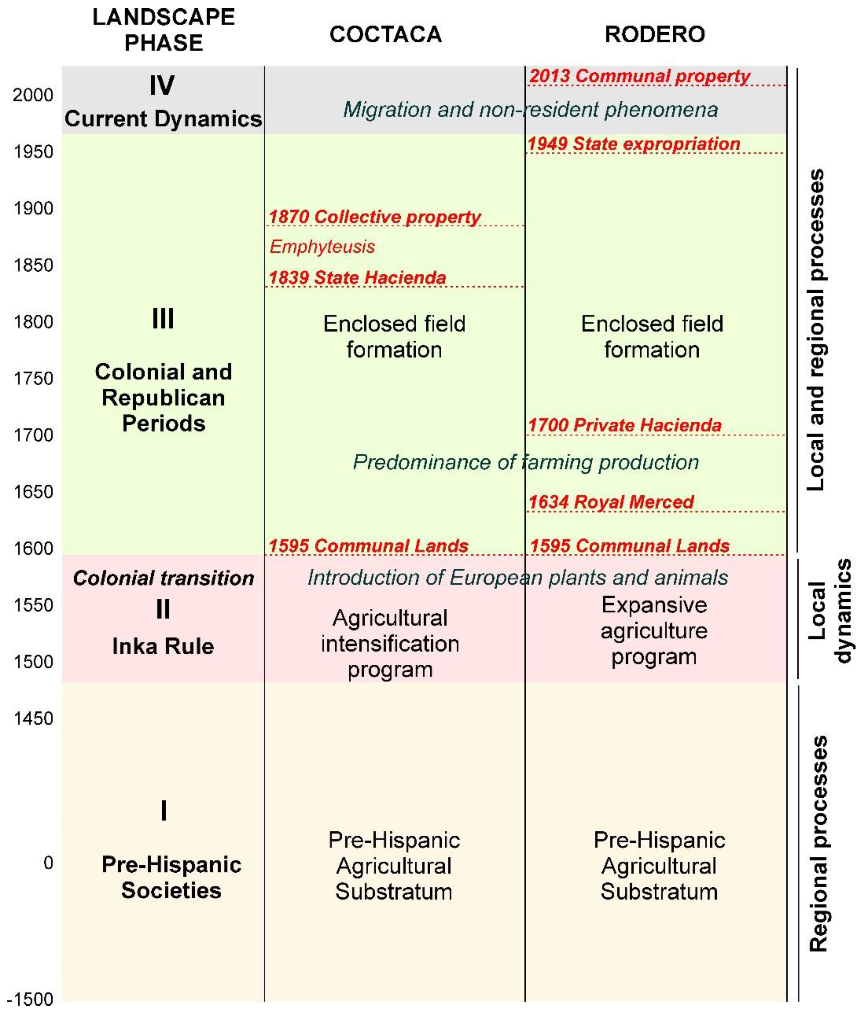
The agricultural landscapes of the Coctaca and Rodero districts share remarkable characteristics. First, the external limits of both represent dramatic interruptions of the anthropised landscape and mark sharp contrasts with the natural areas surrounding them. Second, the heterogeneity of the landscape is striking, especially given that these are adjacent areas with similar environmental conditions. Both the micro-environmental conditions in certain sectors and the different productive dynamics employed over time have contributed to these differences. The agricultural landscape in both areas is composed of four main units, which are spatially and morphologically well defined. Each of these corresponds to a particular chronological, social, and productive phase, all quite different from one another. However, beyond the differences seen between the two districts, the horizontal distribution of these four distinct phases represents one of the main particularities of the agricultural landscape addressed here: the relatively unaltered presence of units corresponding to each chronological phase.
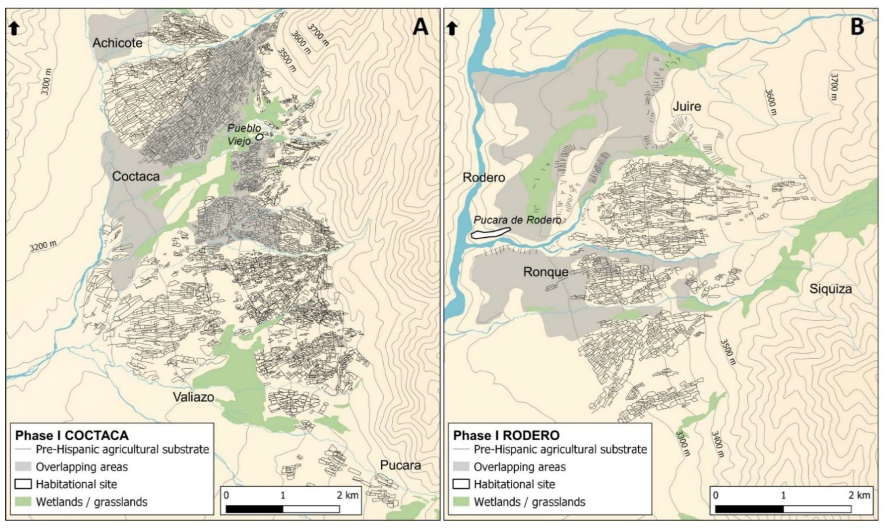
3.1. Phase I. A Pre-Hispanic Agricultural Substratum on a Regional Scale
The first phase identified at these sites consists of an agricultural substratum present in most of the two districts that covers more than 5000 ha (
Figure 2 and
Figure 3). These well-defined areas of cultivation form extensive plots that sometimes exceed 250 ha in size. With some exceptions, most of the areas comprising this substratum were cultivated under a rainfed system, probably for Andean tubers (e.g.,
Solanum tuberosum, Solanum juzepczukii) and chenopods (e.g.,
Chenopodium quinoa, Chenopodium pallidicaule). On the more moderate slopes, we find two principal types of crop terrains: simple large surfaces and large surfaces with traversal stone lines (for erosion prevention). The average size of these varies between 1668 m
2 and 1683 m
2, and they are mostly delimited by not very voluminous linear
despiedres, or stone clearing heaps, which resulted from land clearing activities. Depending on the sector, between 10% and 40% of these surfaces are internally crossed by parallel lines of stones that cut the slopes. These structures even out cultivation areas and reduce water erosion during the rainy season. In addition, on the steeper slopes (10–25%), we find sectors of linear terraces, contour terraces, micro-terraces. and
canchones (enclosed crops).
Although the pre-Hispanic agricultural substrata of both districts share many general characteristics, they do differ in some sectors. For example, most of the large terraced areas located in the localities of Pucara and Ronque are not delimited by the perimeter clearings seen in other places. Beyond Coctaca and Rodero, this same pre-Hispanic agricultural substratum appears in other parts of the Quebrada de Humahuaca, such as in Capla and Alfarcito on the eastern slopes, Raya Raya and Estancia Grande on the western slopes, and in Atumpa to the north of the Quebrada de Humahuaca (
Figure 4). An area with similar characteristics is located some 100 km further south, in the high altitude valleys of Morohuasi and Incahuasi in the Province of Salta.
Unfortunately, we do not have radiocarbon dates that allow us to definitively determine the time of formation of this agricultural substratum at Coctaca and Rodero. However, at nearby Alfarcito, a domestic context associated with similar cultivation areas was dated at 2020 +/− 100 BP and 1970 +/− 70 BP [
30] (p. 129). To this, we can add dates from contexts also linked to agricultural activity at the Antumpa locality, which range between 2900 and 1300 BP [
31] (p. 191), and those of 1510 +/− 70 BP obtained from Estancia Grande [
32] (p. 249). Similarly, a result obtained for one of the agricultural areas of the Quebrada de Morohuasi points to an initial time between 2030 +/− 30 BP and 1745 +/− 30 BP. These and the similarities observed in cultivation surfaces suggest the development of this agricultural substratum during the Formative Period, approximately 2500–1500 BP. With differing degrees of intensity, this agricultural substratum remained in operation during the following centuries without major changes until the period known as Late Regional Development Period (hereafter, LRDP), from the 12th to 15th centuries [
33,
34]. In this region, the LRDP is characterised by a demographic increase and important changes in the mode of establishment of these pre-Hispanic societies, which were mainly concentrated in settlements located in or near the bottom of valleys. Often named
pukará, these settlements were built on promontories near permanent watercourses, which allowed for irrigated crops. However, despite the existence of an extensive agricultural substratum, we found only two settlements from the LRDP in Coctaca and Rodero: Pueblo Viejo in Coctaca [
17] and Pucara de Rodero [
35]. Such a change in the mode of settlement between the initial period of formation of the agricultural substratum and the LRDP was most likely associated with worsening climatic conditions during this period, which was marked by prolonged severe drought [
36].
3.2. Phase II. The Region under Inka Rule
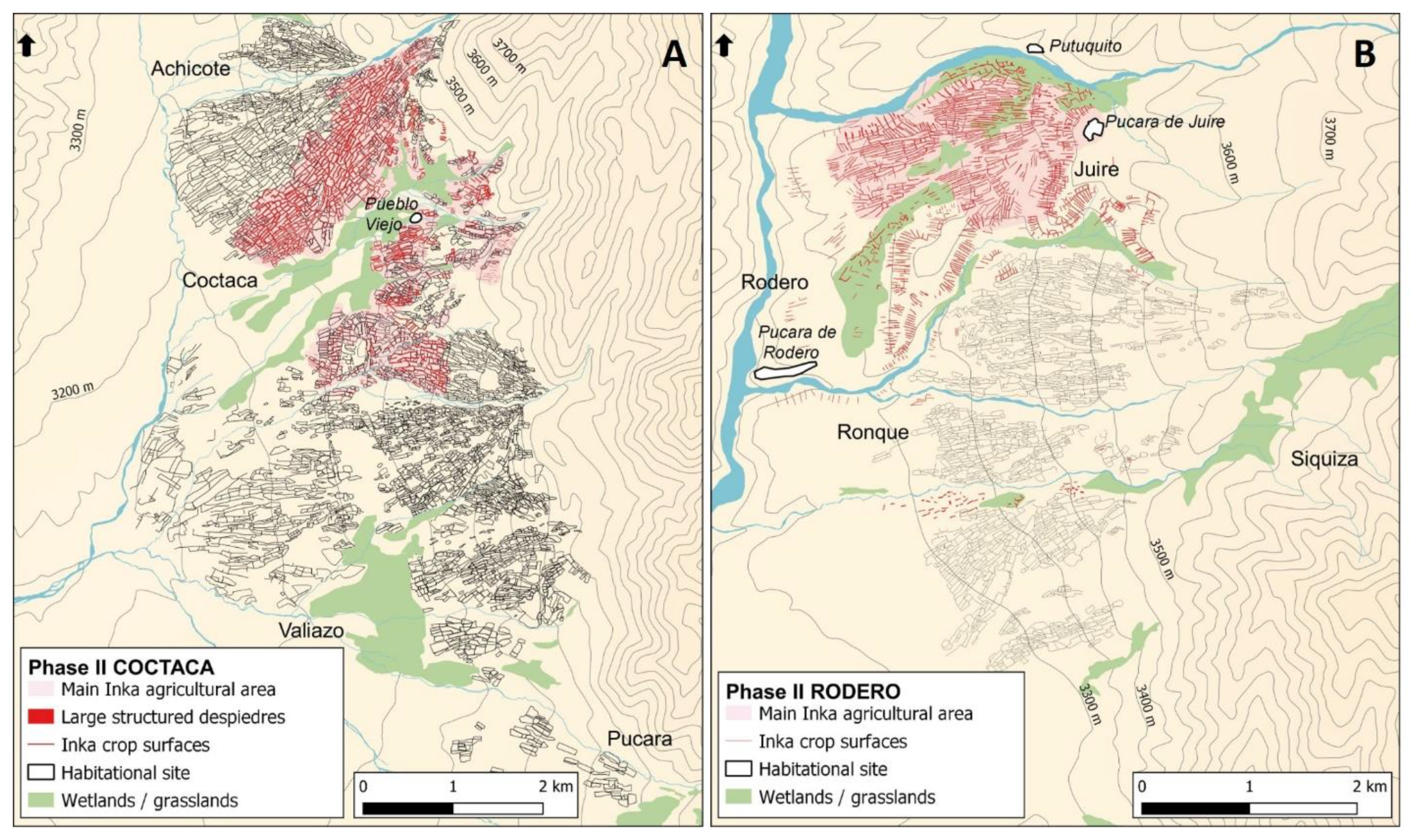
The second phase we identified in the agricultural landscape of Coctaca and Rodero correlates with the establishment of the Inkas in the region during the second half of the 15th century (
Figure 2). From this period forward, we see a notable differentiation in the landscapes of the two districts. With the arrival of the Inkas, agricultural production intensified in Coctaca [
24,
25]. Pre-existing cultivation areas were readapted and new ones were created, covering a total area of approximately 410 ha (
Figure 5A and
Figure 6). In this farming system, four main categories of cultivation areas can be distinguished, each with two or more variants. First, we see cultivation enclosures [
21] that together cover more than 254 ha (
Figure 6B). The intensification of agricultural production undertaken by the Inkas at Coctaca is reflected in the stone clearing heaps, which not only multiplied, but also increased exponentially in volume, and included the removal of even small stones [
24]. In contrast to what we find in the previous substratum, these clearings did not result from a superficial clearing of land, but rather an intensive programme to create and improve the soil.
The enormous investment made by the Inkas to intensify the agricultural production in Coctaca undoubtedly responded to the need to increase harvests and guarantee production in the face of the aggravation of climatic constraints, especially in a period of drought and frost [
34]. However, this enterprise should not be understood only in productive terms or environmental pressures. The extension of the agricultural area, the density of structures in the different productive sectors, the highly elaborate nature of the cultivated surfaces, and the quantity and size of the stone clearing heaps produced a crowded human landscape that transcended agricultural practices. The visual disruption caused by the endless structures stretching up the slopes points to the colossal scale of the Inka undertaking, and hence the enormous capabilities of those who produced them and the massive mobilization and coordination of labour needed to carry out the task. In this sense, the agricultural surfaces of Coctaca were, from the time of their creation, an important manifestation of the colonial power exercised by the Inkas after their arrival in this part of the Andes.
Despite its proximity to Coctaca, the Inka agricultural programme at Rodero differed substantially in that it did not centre on the intensification of production. Instead, the Rodero programme involved the re-adaptation of two previously created types of cultivation surfaces. On the steeper slopes of Rodero, Juire, and Ronque, former
canchones and terraces were reconditioned, delimited by thick lines of parallel clearings, some of which were irrigated with canalisations. In total, these surfaces extend over approximately 100 ha. On the very moderately sloping hillsides that cover the entire locality of Juire, the Inkas created a vast production space, approximately 232 ha, composed mainly of broad longitudinal surfaces (
Figure 4). Some of the stone clearing heaps that delimit these areas extend more than 500 m long. The pattern of wide longitudinal surfaces running down the slope in Juire is similar to what is found in several other
altiplano localities surrounding Lake Titicaca, such as Tiwanaku, Ancoraimes, and San Andrés de Pacajes, which were also colonized by the Inkas.
Inka occupations near these Rodero agricultural surfaces are located at the Pucara de Juire and Putuquito; have been studied by Nielsen [
25]; and show a temporally limited occupation, which would have spanned from the end of the Inka period to the time following the effective establishment of the Spanish colony in the region. A charcoal sample taken from a rubbish pit at Putuquito was dated at 313 +/− 48 BP [
27] (p. 43), which when calibrated gives a temporal range of 1508–1658 (68.2%) and 1480–1798 (95.4%). Bones corresponding to cow phalanges were found on the floors of two enclosures excavated at Pucara de Juire [
27] (p. 40). The dates and material found at these Inka sites indicate their occupation throughout a period of dramatic changes and shifts in power produced by the Spanish colonization of the region. At Juire, some 30 ancient corrals were identified within the large areas of cultivation created by the Inkas, and completely separated from the fenced paddocks. The remains of cattle bones found in two rooms excavated by Nielsen at the Pucara of Juire [
27] (p. 40) suggest an Inka occupation located in the same area as these corrals. These activities may have involved other animals introduced from Europe like goats and sheep along with Andean camelids. The existence of ancient corrals on the cultivation surfaces created by the Inkas suggests a first and early phase of livestock production prior to the effective establishment of the Spanish in the region and the formation of the enclosed-field system.
The Inka control of the region did not continue for long. As in much of the Andes, major changes took place from 1535 onwards, resulting from the imminent establishment of a new Spanish colonial order. These included the following: the spread of a new religion and the persecution of native cults, the introduction of new vegetable and animal species, the emergence of important mining centres and Spanish towns in neighbouring regions, the development of new economic markets and trade circuits, the implementation of far-reaching territorial and tax reforms, and so forth. The new colonial order consolidated in this region between 1595 and 1600, after the dismantling of indigenous resistance and the founding of San Antonio de Omaguaca (currently the town of Humahuaca). For the Inkas that were established in the region, these six decades must have meant a continuous repositioning in power struggles, not only to try to maintain their hegemony, but also to guarantee their survival. In this complex and unstable scenario, Coctaca and Rodero, as well as the rest of the agricultural areas of the region under their control, may have acquired capital importance for the Inkas, because not only did they help sustain part of the economy, but also played a role in strategies of resistance and practices of retribution. However, the Inkas were displaced from their positions of power and replaced by local indigenous leaders and authorities [
37,
38] with the consolidation of Spanish colonial power.
3.3. Phase III. The Establishment of Spanish Colonial Rule, Republican Economies, and the Enclosed-Field System
The creation of the village of San Antonio de Omaguaca between 1595 and 1600 [
37,
38] marked the beginning of a new and prolonged period in which the productive matrix of the region progressively changed, and further accentuated some of the already existing differences in the agrarian landscapes of Coctaca and Rodero. However, throughout these changes, the landscapes of both districts became closer to one another in other ways (
Figure 2).
In the locality of Coctaca, several indicators suggest that a considerable part of the agricultural sectors prepared by the Inkas continued to be cultivated. The cultivated surfaces of these sectors are notoriously better preserved than the rest, and there is practically no overlapping. Another indicator is the number and size of giant cacti or
cardones (
Trichocereus atacamensis) found in the cultivated areas, which are substantially smaller and less numerous than in the nearby abandoned areas. Likewise, soil samples taken from these cultivation areas revealed a higher phosphate content than those less conserved, a difference related to a greater availability of animal manure to enrich the soils. In addition, this continuity is explicitly referenced in some historical documentation, in particular, in the testament of Don Andrés Choque, cacique (local indigenous authority) of Omaguaca. In this document, dated 1632, Don Andrés declares as his own property four
chacras (cultivation areas) located “upriver from this locality (Humahuaca)”, that is, in the Coctaca area [
39] (p. 80). The combination of evidence from different sources points to some degree of continued used of these units.
However, the introduction of new species of domestic animals from Europe reoriented much of the production in the region towards the development of livestock. Another colonial document indicates that, by 1616, the indigenous authorities of Omaguaca and Tilcara paid tribute for the sheep they raised [
38] (p. 307). In his will and testament, Don Andrés Choque declared that he also owned two
haciendas, or rural estates, in Coctaca and Siquiza, principally dedicated for livestock, and that he owned 20 horses, 2 mules, 2 pairs of oxen, 20 cows, and around 400 sheep [
39] (pp. 79–80). The development of animal husbandry quickly led to the creation of fenced spaces with stone walls for grazing and shelter. Local inhabitants identify these spaces as
potreros. These represent a progressive improvement of natural pastures and are also compatible with the extensive cultivation of forage crops. At this same time, the number of corrals multiplied (
Figure 7). They were located inside the paddocks, and either attached to the perimeter walls or just outside. This emerging dynamic led to the formation of enclosed farms in sectors that were close to watercourses or with a greater abundance of pastures, which represented a change in the mode of settlement with more dispersed into independent family and productive units. Though this process was created by very distinct processes, especially in terms of vegetation use, the types of fenced spaces created present similarities with the European bocage landscape [
2].
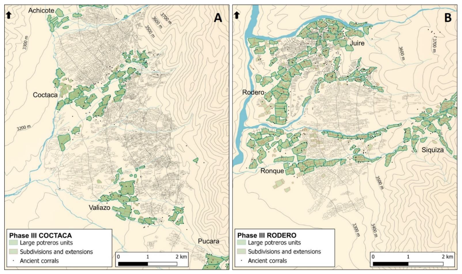
In the Coctaca area, the enclosed-field formation process developed with similar characteristics in all of the four localities and extended over 396 ha (
Figure 8A). Most of the fenced paddocks resulted from the segmentation of 88 initial units, which can be discerned by their well-defined perimeter walls. Individual paddocks can exceed 10 ha in size. The progressive segmentation of these initial units over generations resulted in the creation of 429 fenced paddocks, with average surface areas of 0.9 ha. We should note that, in the locality of Coctaca, only part of the fenced paddocks (18.5 ha) overlap with the agricultural sectors created by the Inkas.
This same process of enclosed-field formation took place at Rodero, though with some differences. Despite covering a smaller area than Coctaca, these processes occurred on a greater scale in Rodero and with more intensity. The fenced paddocks created during this period occupy a total of 519 ha (
Figure 8B). Most of these paddocks pertain to an initial group of 129 units, and were then segmented into 684 smaller ones, with an average area of 0.74 ha. The fenced paddocks of Rodero not only occupy a larger area on moderately steep slopes, a significant portion (200) extend over higher slopes and ravines, even exceeding 3850 m in altitude. Another aspect of the enclosed-field system at Rodero contrasts significantly with Coctaca: In Juire, most of the fenced paddocks (90 units) are located above the cultivation areas previously created by the Inkas, and the previous stone heaps were used to build the perimeter walls of the new structures. This overlap shows the compatibility of these particular cultivation areas with the livestock farming practices mentioned above.
The foundation of the
Pueblo de Indios (a settlement created by Spanish rulers) called San Antonio de Omaguaca, in 1595–1600, initially involved the creation of a legal construction of vast communal lands, of which the districts of Coctaca and Rodero formed part. Agricultural production on these communal lands remained in the hands of the indigenous population in exchange for the payment of tribute. However, once the tax obligations to the
encomendero, the Spanish colonial figure given dominion over the indigenous people and their lands, had been fulfilled, the indigenous people were then able to trade or market their agricultural products independently. However, not long after, in 1634, the indigenous people of Rodero were dispossessed of their communal lands, which became part of the
Merced, or crown land-grant, of Colanzulí [
40] (p. 17). This initial stage is followed by a prolonged period of time, over 300 years, in which no significant changes can be observed in the landscape of both districts apart from the process of formation of the enclosed-fields.
The formation of enclosed-field systems and the growth in livestock production may have been directly connected to important structural changes produced by the creation of the Spanish colonial economy. The consolidation of the Spanish regime brought on a prolonged period of demographic decline in the indigenous populations, a result of migration and successive cycles of plagues [
38]. However, the period following the solidification of this power structure was also marked by relative political stability, despite fluctuations in the regional economy. Following cycles of growth, a sustained decrease in production in the Andean mines, beginning in the second half of the 17th century, impacted markets and circuits for foodstuffs and related products that had developed within the region. This network developed during the Colonial Period crossed the Andes to link agricultural production and trade with mines in the Andean highlands via extensive transport routes. These roads and paths passed through the districts of Rodero and Coctaca and may have played an important role in the expansion of agricultural structures related to pasture and the forage production. Humahuaca was an important stopping post in these circuits [
41].
The placement of the region within a larger economic circuit and political structures provides interesting insight into the very different trajectories of both of these districts with respect to land tenure. Rodero remained a private property and, from 1778, was a
hacienda and latifundia called Nuestra Señora de la Concepción de Rodero [
42] (p. 59). After successive changes in ownership at the end of the colonial period and through the 19th century, it was only in 1949 that the lands of Rodero ceased to be a private estate. This change followed the promulgation of National Decree No. 18.341, by the then President Juan Domingo Perón, who ordered the expropriation of latifundia in the northwest. After passing through the hands of the province (Jujuy), legal possession of the cattle pastures in Rodero progressively passed to their historical indigenous owners. However, it was not until 2013 that the entirety of Rodero’s lands were collectively transferred to the newly formed aboriginal community of Rodero (provincial decree No. 2386). In other words, it took more than 450 years for the people of Rodero to regain full control of their ancestral lands. Coctaca’s history is quite different. Those lands remained communal until the 1830s, when, following independence, they were converted into
Estancias del Estado, or agricultural and pasture lands owned by and under the control of the State. This change meant that the State leased the lands to residents. With this, the State began to implement a policy of emphyteusis over the course of several decades [
43]. Beginning in the 1860s, those lands held in emphyteusis began to be privatised, and were principally acquired by regional landowners. However, as Fandos and Teruel [
44] (p. 227) point out, a report from 1870 states that the
Estancias del Estado in Coctaca, Valiazo, and Pucara were bought by a group of at least 17 individuals, who were none other than representatives of the local indigenous population. In other words, while these processes and reforms led to the privatisation and loss of control in Rodero, residents of Coctaca were able to hold onto their lands. This collective ownership continues to this day in the locality of Coctaca, in the form of a condominium, with the title of ownership being updated in each generation. Continuities in Coctaca may have extended beyond control of lands as well. During the summer of 1931, the archaeologist Eduardo Casanova carried out a limited research campaign at Coctaca, during which he excavated different pre-Hispanic contexts and toured the agricultural sectors. In the resulting publication, Casanova notes that the local inhabitants continue to cultivate “in the same stubble fields as the pre-Hispanic Indians did several centuries ago” [
17] (p. 27), explaining that, due to the exhaustion of the springs “today barely 10 percent of the fields that were once worked are cultivated” [
17] (p. 30). While this percentage may be exaggerated, there is no doubt that, in 1931, a significant portion of Coctaca’s pre-Hispanic agricultural areas were still being cultivated by local people.
3.4. Phase IV. Contemporary Communities with Non-Resident Neighbours
The social and economic transformations that occurred in the last decades of the 20th century define the last phase of the agrarian landscape of Coctaca and Rodero, during which both the State and neoliberal forces interacted to produce important changes from the 1980s to today [
45,
46] (
Figure 2). Neoliberal policies dismantled many of the structural foundations of the regional economy and later periods of increased State presence attempted to alter these dynamics. Later interventions took the form of the development of public infrastructure (expansion of trunk and secondary roads, gas pipeline, health posts, and so on) and the intervention of national institutions for productive development (INTA, IPAF, Subsecretaría de Agricultura Familiar, Universidad de Jujuy, Programa ProHuerta, and so on), and transformed the State into a principal source of employment (municipal officials, health system, education, police, and so on) and of social support (work plans, production and housing loans, educational grants, family allowances, pensions for housewives and people without contributions, and so on).
However, despite the increased presence of the State after the shock of the most intensive neoliberal reforms, the region has experienced a sustained depopulation in rural areas and the replacement of the peasant way of life by a more urban one. This process intensified from the 1980s onwards [
45]. In Coctaca and Rodero districts, the vast majority of the population migrated to the departmental capital of Humahuaca (between 8 and 16 km); to the provincial capital of San Salvador (130 km); to other major cities in the province of Jujuy (Palpalá, Perico); and to a lesser extent to other cities in Argentina, mainly Buenos Aires. However, despite permanent residence in these urban localities, individuals and families continue to maintain strong ties with their communities of origin, even participating in collective decision-making and administrative positions. For example, the president of the Centro Vecinal de Coctaca resides in the city of Humahuaca and the Municipal Commissioner of Rodero in the city of Palpalá (164 km away). Fully recognised as members of the community, this non-resident population maintains family homes and builds new dwellings, and the vast majority continue to farm their land, although on a substantially smaller scale than their predecessors. The growing importance of this category of non-resident neighbours can be clearly seen in the large disparity between the population information provided by the last census (2010) and the number of dwellings currently used. In Rodero, the 2010 census details a population of only 30 people, 16 women and 14 men, for the entire district. This figure bears no relation to the 205 functional residential units in the area. For Coctaca, the same census indicates a population of 144 people (
Figure 9A), a number higher than in Rodero, but also unrelated to the 202 functional residential units found there (
Figure 9B).
The agricultural production of both districts reflects these changes in the way of life of the local population. The total area currently cultivated in the Coctaca area is around 52 ha, spread over 750 cultivation units, each with an average area of 450 m2. In Rodero, the total cultivated area is 45 ha, spread over 600 units of an average size similar to those in Coctaca. The small size of the cultivation areas reflects the fact that production is now family-scale agriculture aimed mainly at self-consumption, and to a lesser extent the local market. Depending on the distance from their actual residences, these non-resident villagers work their land and maintain their crops several times during the week, after their regular work day, or during weekends and holiday periods.
Practically all of the current cultivation in Coctaca and Rodero occurs within fenced paddocks, a dynamic directly connected to questions of ownership in addition to the other compatibilities mentioned previously. In the 1960s, the national government granted ownership of the paddocks in Rodero “free of charge and definitively”, and some were subsequently bought and sold by local inhabitants [
45] (pp. 45, 178). The generational fragmentation of the enclosed-fields and the kinship relations within each locality mean that it is common for the same producer to own and use plots in different paddocks. The generalised use of fenced paddocks for agriculture reflects the decline of livestock farming practices, something also seen in the abandonment of corrals. This decrease correlates to population changes [
45] (p. 207) because, unlike crop farming, animal husbandry requires greater permanence. As a result, it is mainly the permanent residents who continue this activity. In terms of the agricultural landscape, it is particularly interesting to note that, in Juire, a large part of the current crops are found both within the fenced paddocks and on the former cultivation areas created by the Inkas. Thus, after a long period in which these former agricultural areas were integrated into the cattle pastures, they have returned to their original function, though no longer part of an extensive and centralised system, but rather a peasant mode much closer to the family farming model.
Finally, since the mid-1980s, the tourist industry has grown in tandem with the advancement of ideas of heritage preservation, in which the pre-Hispanic past plays a prominent role. The UNESCO declaration of the Quebrada of Humahuaca as a World Heritage Site in 2003 intensified this process. Though this dynamic has not yet impacted the landscapes of the high slopes, unlike the towns on the valley floor, it has changed the way that local population see their territories, the natural attractions found there, and their culture and archaeological remains—all of which have become potential economic resources. From the beginning of this change, Coctaca appeared to be one of the most promoted tourist sites in the northern sector of the Quebrada de Humahuaca, because it is such a major landmark of pre-Hispanic agriculture. However, few tourists visit Coctaca compared with other places in the Quebrada and, as most that do come in organised tours, they do not stay long. Despite having been frequented by tourists for at least two decades now and the manifest interest of the local inhabitants in generating economic resources from this activity, no individual or collective undertaking has been developed to enhance the ancient agricultural system for tourism. There are no guides to show visitors the particularities of the site, no circuits, no explanatory signage, no meeting spaces for tourists, no sanitary facilities, and so on. No stalls sell handicrafts or food, like there are in most of the tourist towns in the Quebrada, and the two shops in the village have very few products. While this can be explained by a variety of factors, including the small number of visitors, lack of training, and lack of time or investments, other symbolic and religious reasons play an important role.
4. Discussion
By combining an analysis of the agrarian landscapes of the Coctaca and Rodero districts with an examination of the cartographic, archaeological, and historical records, we identified the main phases involved in their formation. The first phase is marked by the flourishing of village societies in the region, during the Formative Period that adopted a way of life based on an agricultural and pastoral economy. The vast agricultural substratum present in both districts, as well as in some other more distant localities, took shape during this first period. The second phase is related to the establishment of the Inkas in the region. This period, unlike the previous one, was much more limited in time, most probably between the end of the 15th and the beginning of the 16th century. However, the marked differences in the agricultural programme carried out by the Inkas in the districts of Coctaca and Rodero are noteworthy. In the locality of Coctaca, the monumental investment made by the Inkas in the development of old cultivation areas aimed to not only intensify agricultural production, but also manifest their power at the regional level. In contrast, in the locality of Juire, they advanced an extensive agricultural programme, based mainly on the cultivation of large, longitudinal plots, which required no great investment in terms of labour. The third phase began shortly after the definitive establishment of the Spanish colonial system in the region at the end of the 16th century, when profound political, social, economic, and demographic changes took place. This phase of the agrarian landscape saw the formation of enclosed-fields for livestock and dispersed settlements around them, a process favoured by the introduction of new species of plants and domestic animals. In this new scenario, data indicate the continued cultivation of a considerable part of the agricultural areas previously created by the Inkas in Coctaca, with the production used to supply the new mining sites in the region and provide food and pasture to pack animals transiting through the regional networks of trade linked to colonial productive and urban centres.
The third phase is also characterized by other particularly significant changes. While Rodero first formed part of a crown land grant and later a private
hacienda from 1634, lands in Coctaca remained, for a long period of time, communal lands that were attached to the Indian village of Omaguaca. While these differences were decisive for the indigenous people affected by them, the changes in land tenure do not correspond to starkly different changes in the evolution of the agrarian landscape; the same processes of enclosed-field formation are seen in both districts during this period. Moreover, over time, two very similar settlements emerged in both areas that would later become the administrative seats of both districts. This may have been due to the fact that the
haciendas in the region were less profitable than the mines and geographically distant from the principal urban centres. As a result, these estates often relied on tenant production [
47]. This meant that, in practice, little difference in forms of production may have existed in the day to day functioning of the private properties and the communal lands of the region with respect to land use. The principal difference was that the indigenous people on the estates paid their grazing and land use rights to the landowners. In fact, the name Rodero refers to the word
rodeo, which is the collection of animals, and from
roda, the payment for rights to pasture livestock. Residents of the communal lands in Coctaca paid taxes or paid in labour for their lands directly to the State. However, what is very surprising about the enclosed-fields at both Coctaca and Rodero is the evident segmentation of the fenced paddocks, something that indicates a generational transmission in the tenure of these spaces. In fact, after the expropriation of the Rodero estate in the 1960s, the first thing the nation State did was to adjudicate the ownership of these pastures to their historical indigenous owners.
The last phase we identified in our study encompasses a period of time marked by dynamics surrounding migration to urban centres that began in the last decades of the twentieth century. However, despite the census records that indicate a significant decrease in population, we observe a considerable increase in the number of housing units. This is directly connected to the growth in numbers of “non-resident neighbours”, who, despite living and working elsewhere, continue to maintain strong ties with their localities of origin and actively participate in the social life of the community, a livelihood pattern also seen in other rural areas of the Andes [
48] and other parts of the world [
49]. In this sense, the concept of community is now much broader and more complex than it was a century ago, and does not necessarily require the permanent residence of members, nor that their principal work activities occur within the community.
Two broader perspectives help to contextualize the state of current-day land use in our study area. Despite proximity, the decrease in agricultural production observed in Coctaca and Rodero is not replicated in the localities situated along the bottom of the Quebrada of Humahuaca. These have better soil and access to water for irrigation and, therefore, concentrate the bulk of regional agricultural activity. The differences become even more intense when one considers the agricultural dynamics occurring on the vast plains located east of the Andes in the region, like the Chaco and Pampa regions. There, the growth of agricultural and livestock production has been a continuous process since the nineteenth century, and the area has been the site of a major expansion of soy production in the last decades of the twentieth century [
50].
On a more conceptual level, first, we see that the same landscape structure seen in both districts is replicated through four main phases, each the result of social, economic, and political processes on a regional and macro-regional scale. At the same time, we find in each district, and even locality, some different productive dynamics that impacted the landscape. Certainly, the interference of regional processes and local dynamics in the formation of the agricultural landscape is a phenomenon present in all rural areas of the planet [
51]. This is also reminiscent of two situations found at a global scale. It certainly fits the definition of marginalised and abandoned landscapes proposed by Plieninger and Bieling [
52], which are frequently found in remote and mountainous regions of the planet with arid climatic conditions that condition the sustained development of agricultural production (climatic risk, soil erosion, geographical isolation) and foment land abandonment or the halting of productive enterprises. Likewise, abandoned agricultural areas and terraced surfaces are found in different parts of the Andes as well as in Europe and around the world [
53,
54,
55]. While in many places, these dynamics are relatively recent and related to increased scale and mechanization of agricultural production, in others, we find systems abandoned in the remote past that remain fossilised in the landscape. The particularities seen in the agrarian landscapes of Coctaca and Rodero centre on the scale, density, and state of conservation of the ancient structures, which constitute remarkably well-defined presentations of the chronologically disparate processes and dynamics that shaped them. In effect, it is a multi-temporal landscape, with past and present integrated on the same experiential plane.
In the conceptualisation of anthropised landscapes, whether in rural or urban settings, researchers frequently invoke the figure of the palimpsest [
56,
57,
58]. The term refers to the superimposition over time, in the same space, of productive and residential surfaces and structures, with the new ones covering and partially erasing the older ones on the surface. The agricultural landscape of Coctaca and Rodero does not correspond to the classic metaphor of the palimpsest, given that, except in a few places, the old crop surfaces and other agricultural structures have generally not been destroyed to make way for new ones. In certain sectors, the remains of the different productive phases have been added horizontally, while in others, they are superimposed to form dense multi-temporal conglomerates that correspond to the precise concept of cumulative palimpsests proposed by Bailey [
59] (pp. 204–207). In this sense, the agricultural landscape observed in Coctaca and Rodero is a composition or agglutinating combination of independent, but not necessarily unrelated, chronotopes (
Figure 10).
The multi-temporal character of the agricultural landscape of Coctaca and Rodero relates to the spatial and productive discontinuities of each phase with respect to the previous ones, especially the pre-Hispanic agricultural systems. While those extended throughout both districts and covered almost the entire anthropised space, the subsequent three phases occurred in a more sectored manner, overlapping mainly in those areas with better conditions for animal grazing and irrigated crops (
Figure 11). After being abandoned, most of the pre-Hispanic cultivated areas remained as such and were only altered by the passage of time and environmental agents, thus giving rise to the formation of the vast fossilised agricultural spaces that can be seen today. The same taphonomy appears in fenced paddocks that have been definitively abandoned.
The dynamics of abandonment are not limited to agricultural and pastoral spaces, nor only the remote past. Both districts include significant numbers of houses and corrals that are in a state of ruin or total abandonment (
Figure 12). Such buildings are located in close proximity to currently inhabited dwellings, often on the same property. This is because houses and corrals are generally used only by the nuclear family involved in their construction. Once these people have died, their dwellings are not used again, nor are they demolished or reconditioned for another use. Similarly, it is quite common to find in Coctaca and Rodero houses that continue to be inhabited, despite the fact that one or more rooms have been abandoned and have no roofs. This is the result of a widespread practice in the region, and in much of the Andes, which consists of abandoning, after the death of a family member, the rooms occupied by them and dismantling the roofs in order to reuse the materials in new constructions [
60]. This points to important aspects of the relationship that local people maintain with the past and its material remains. As seen throughout the region, the current inhabitants of Coctaca and Rodero distinguish between those remains from the distant past, which we identify as pre-Hispanic or archaeological, and those linked to the recent past. They use the terms
antigal to refer to the ruins of pre-Hispanic settlements and funerary structures, and
ronque for ancient agricultural fields. Elsewhere in the Andes, these remote remains are generically identified as
chullpas or
gentilares. Regardless of the specific term used in different parts of the Andes, all these structures are considered remnants of a pre-solar era when the Earth was inhabited by a different humanity than today. It was a period of shadows and a world lacking differentiation. That time was also marked by, among other things, great fertility of the land. The existence of vast fossilised agricultural systems, such as those found at Coctaca and Rodero, is tangible proof of the fertility of this mythical time. The sudden appearance of the sun brought about the end of this world and the extinction of this earlier humanity. Therefore, spirits remain active in those spaces where the remains of their dwellings, corrals, and cultivation areas are to be found. In fact, there are frequent accounts that tell how, during the night, these beings return to their old plots of land to continue working on their crops. In any case, the energy emanated by these spirits potentially threatens human beings and is the source of some pathologies that are widespread in the Andes (fright, loss of spirit, possession), some of which can even lead to death if they do not receive the appropriate ritual treatment [
61,
62]. For this reason, inhabitants of rural Andean areas circulate these spaces very cautiously and try to avoid any interventions in them. Something similar happens with remains that are ascribed to a more recent past (fenced pastures, ruins of old dwellings, abandoned corrals, and so on), as they are directly linked to the dead, be they ancestors of the place or direct ancestors of the current inhabitants. Every year at the beginning of November, for the feast of All Saints, the dead return to their communities and visit their old dwellings and relatives who are still alive. However, unlike the spirits of the
antigales, the dead that are closer to the inhabitants can intervene beneficially in the future of individuals and communities, and even mediate inclement weather, influence the fertility of crops and livestock, or the fortunes of businesses [
63,
64]. For this reason, their return for All Saints’ Day, which coincides with the beginning of the rainy season, is one of the main festivities of the year in the Andes and one in which they are celebrated, remembered, thanked, and prayed to.
So, whether as a precaution or because of their connections to the dead, the material vestiges of the past are respected and, unless there are circumstances that justify it, generally preserved from any intervention. Further than that, however, these are spaces and materialities in which ontological explanations about the world and the unwritten histories of peoples take root; places where collective memory is reproduced [
65]. As we have seen in the cases of Coctaca and Rodero, this does not only concern some specific places, but the totality of the inhabited spaces. From this perspective, the close relationship that local people maintain with the vestiges of the past in a multi-temporal physical environment challenges us to read the agrarian landscape beyond a framework focused on the form seen by an observer at one point in time. If, as indicated, landscapes embody human history as “pattern of activities ‘collapsed’ into an array of features” [
66] (p. 162), they are also very much living processes [
67]. In their role as a factor shaping lives today in Coctaca and Rodero, the landscapes reveal their continued vitality.


