
A Review on the Overall Optimization of Production–Living–Ecological Space: Theoretical Basis and Conceptual Framework


1
Institute of Geographic Sciences and Natural Resources Research, Chinese Academy of Sciences, No. 11A Datun Road, Chaoyang District, Beijing 100101, China
2
College of Resources and Environment, University of Chinese Academy of Sciences, No. 19A Yuquan Road, Haidian District, Beijing 100049, China
3
Key Laboratory of Carrying Capacity Assessment for Resource and Environment, Ministry of Natural Resources, No. 46 Fuchengmen Road, Xicheng District, Beijing 100812, China
4
College of Geoscience and Surveying Engineering, China University of Mining and Technology, No. 11 Xueyuan Road, Haidian District, Beijing 100083, China
*
Author to whom correspondence should be addressed.
Land 2022, 11(3), 345; https://0-doi-org.brum.beds.ac.uk/10.3390/land11030345
Submission received: 31 December 2021
/
Revised: 22 February 2022
/
Accepted: 24 February 2022
/
Published: 25 February 2022
(This article belongs to the Special Issue Land Use Conflict Detection and Multi-Objective Optimization Based on the Productivity, Sustainability, and Livability Perspective)
Abstract
:The 18th National Congress of the Communist Party of China put forward the optimization of territorial space development patterns as the primary measure of ecological civilization construction, and put forward the goal of “promoting intensive and efficient production space, livable and moderate living space, and beautiful (picturesque scenery) ecological space”. Through literature research and summing induction, this paper combs the research progress of the overall optimization of “Production–Living–Ecological” space (PLES) systematically. It is found that the existing work mainly focuses on the overall optimization of PLES from the perspectives of land-use quality, land-use suitability evaluation, resource and environmental carrying capacity, and comparative advantages. However, due to the lack of understanding of the scientific connotation of PLES, and the imperfect construction of quantitative identification methods and classification system, there are many problems in the technical approaches of the overall optimization of PLES, which remain to be clarified. In the future, the technological approach to the overall optimization of PLES should be guided by the vision of building a beautiful China, with the theory of a human–Earth coupling system as the core, and systematically build a theoretical system and technical framework to identify and optimize territorial space.
1. Introduction
Since China’s reform and opening up, with the acceleration of industrialization, large-scale land resources have been continuously developed. Urban construction land is also faced with environmental problems, such as occupying ecological space, air pollution, water pollution, and ecological imbalance. How to coordinate social and economic development with ecological and environmental protection has become the core issue of sustainable development research in China. At the 18th National Congress of the Communist Party, the five-sphere integrated strategy of giving prominence to ecological progress was put forward from an overall and strategic perspective. At the same time, it pointed out that optimizing the spatial development pattern of the national territory should be taken as the primary measure of ecological civilization construction, so as to promote intensive and efficient production space, livable and appropriate living space, and beautiful (picturesque scenery) ecological space [1,2,3].The “Production–Living–Ecological” space (production space, living space, and ecological space, PLES), as the main body of the spatial pattern optimization, has become an important foundation for the planning and implementation of functional zones at all levels, the establishment of the spatial planning system, and the improvement of the system for the development and protection of territorial space. At the third Plenary Session of the 18th CPC Central Committee in November 2013, a number of major issues concerning comprehensively deepening reform were discussed in depth, and the Decision of the CPC Central Committee on Some Major Issues Concerning Comprehensively Deepening Reform was adopted. The decision calls for accelerating the construction of an ecological civilization system, establishing a spatial planning system, delimiting the limits of space development control, and implementing use control. In May 2019, the Opinions of the CPC Central Committee and the State Council on Establishing a Territorial Space Planning System and Supervising its Implementation identified the main objectives of territorial space planning, which included that “By 2035, China will comprehensively modernize its governance system and capacity of land and space, and basically form the national space pattern featuring intensive and efficient production space, livable and appropriate living space, beautiful ecological space, secure, harmonious, competitive and sustainable.”
PLES basically covers the space activity scope of human social life, and is the basic carrier of human economic and social development. The three are independent and inter-related, with a symbiotic integration and restriction effect. The synergistic effect of “Production–Living–Ecological” (PLE) will be greater than the sum of its parts [4]. Coordinating the spatial function and land-use structure under the linkage of PLES; promoting the coordinated development of the quantity structure and spatial layout of PLES; and taking into account factors such as population distribution, economic development, territorial space utilization, and ecological and environmental protection to improve the layout of PLES in a scientific and reasonable way is the key measure to promote the building of a beautiful China, and accelerate the transformation of the way of production and living to “green” under the overall layout of the national ecological civilization construction [5]. It is also an important means to promote high-quality development and quality of life with the center of people, which is both necessary in reality, and urgent of the times. Since the report of the 18th CPC National Congress first clarified the development requirements of PLES from the height of national strategy, PLES has become the practice subject and research focus of territorial space planning and urban planning [6]. At present, the relevant theoretical research and local practice of PLES are still in the exploratory stage [7]. Related research and work mostly focused on the formulation of policies and management methods, or the evaluation and analysis of a single “space”, such as demarcating the red line for basic farmland protection, the red line for ecological protection, and the boundary of urban development. These studies lack comprehensive and integrated studies of PLES in the whole domain, and lack systematic and comprehensive technical ideas and application practices of overall optimization of PLES.
Based on the classification, identification, evaluation, and optimization of PLES as the theme, through filtering and sorting the published literature since 2012 (the 18th CPC National Congress), the optimization theory, method, and practice of PLES was combed systematically, which oriented the national spatial planning. In order to provide theoretical support for the optimization of territorial space development, protection, and planning, this study also tries to put forward the development direction of the overall optimization of PLES in the future.
2. Connotation and Development of PLES
2.1. Definition of PLES
As early as 1984, some scholars in China put forward the dialectical relationship of PLE in the process of material exchange between human beings and nature [8]. Subsequently, the concept of PLE began to appear in research on sociology and ecology, and it was not until 2002 that PLE was gradually applied to research on geography [9]. At that time, research was guided only by the literal meaning of PLE, rather than the core of the research, and did not give further explanations for its scientific connotations. Different scholars have discussed the definition of the basic connotation of PLES from different perspectives. Some scholars started from the top-level design of national planning and correlated PLES with main function zoning. These authors argued that ecological space mainly has ecological functions, accumulates ecological capital, and relates to the functions of production and living; production space focuses on the accumulation of production capital, and relates to living functions, which is equivalent to the key development zone and optimized development zone in the main functional area of the country; and living space mainly plays the service function of living, accumulates living capital, and gives play to the functions of both production and ecology. This understanding is equivalent to restricted development zones in the national main function area [10]. However, main function zoning is only stipulated at the national and provincial levels, whereas the basic evaluation unit is the county administrative region, which is unable to control smaller spatial areas, and lacks overall planning capabilities [11].
Wu [12] was the first to clearly define PLES from the perspective of the PLE function. He argued that ecological space refers to an area featuring important ecological functions, with ecological products and services as its main function; production space is an area with the main function of providing industrial products, agricultural products, and service products, primarily including industrial and mining construction space and agricultural production space; and living space is a region that provides the main function of human habitation and public activity, primarily including the urban and town settlement space and rural living space. Together, the three dimensions of production, living, and ecology constitute the whole national space. Zhu [13,14] enriched the above definition while also emphasizing the dominant function of land-use, arguing that production space is mainly used for production and operation activities. Living space provides places for people to live, consume, and engage in recreation, whereas ecological space is the sum of the environment needed or occupied by a species in a macroscopic stable state, and provides ecological products necessary for human beings.
Territorial space is a complex geographical system, and includes land, water, mineral resources, ecology, social economy, and other different resource elements; moreover, there are extremely complex interactions among the elements [15]. From this perspective, PLES covers biophysical processes; direct and indirect production; as well as spiritual, cultural, leisure, and aesthetic needs, and represents the product of the synergy and coupling of multiple systems of nature, society, and economy [16,17,18]. Among them, ecological space is the foundation that enables production space and living space to realize their own functions, and is key to coordinating the relationship between humans and land, and achieving regional sustainable development [19,20].
2.2. Classification of PLES
There are two types of studies on the classification of PLES. One type classifies different land uses based on the single functions of production space, living space, and ecological space. For example, Hu [21] and others established a classification system for PLES at the scales of urban and rural regions and urban built-up areas by referring to the Standard of Urban Land Classification and Planning and Construction Land. According to the dominant function of a single land category, Ma [22] proposed a one-to-one correspondence between the secondary land-use types and PLES, and conducted a classification study on PLES. This classification method simplified the complex relationship between these three spaces, but ignored the complex multiple functions of land. For example, arable land (paddy field and dry land) was uniformly divided into production space, but its ecological function characteristics were not fully considered. The other classification method is mainly based on the multiple functions of land-use. This method extends the function of PLE, lists the land by each separate compound function type, and classifies the land according to the land-use standard on this basis [23]. Starting from the main function of land, and taking other functions into account, Zhang et al. [24] incorporated the concept of ecological land, and constructed a classification system of Production–Living–Ecological land (PLEL) use at a national scale to coordinate the space of PLE land. This method compensates for the shortcoming that land ecological function is not sufficiently considered in land-use classification, and realizes the connection between land function classification, land-use classification, and urban land classification. Thus, this method is widely used in production practice and scientific research related to land function regulations, ecological political achievement assessments, and ecological environmental effects [25,26,27]. In addition, based on the theoretical connotations of PLEL, Liu et al. [28] analyzed the dialectical relationship between land-use functions and land-use types from the perspective of the complexity of the land PLE multifunctional complex, and constructed a classification standard system for PLEL according to the national classification standard of land-use status. To some extent, this classification method also reflects that PLES is, in essence, a result of the evolution and regional differentiation of the human–Earth relationship system.
Existing research on the identification of mainstream PLES methods can be divided into research using the merge classification method and the quantitative measurement method. The former involves qualitative research, which mainly merges and classifies land-use data based on yearbook data, national land surveys, and remote-sensing image data to identify PLES [29,30,31,32,33]. This method facilitates the connection between land-use function and classification standards, and compensates for the deficiency of ecological functions in land-use classification to some extent. Thus, this method has been widely used in practical fields [34,35,36]. However, this method produces errors in the recognition results, as it ignores the composite function of space. Moreover, these results will be different under different classification systems. Most of the latter systems focus on quantitative analysis, and mainly use the calculation function group of the spatial function value to establish a measurement system for land-use function, and identify PLES through a quantitative measure of the leading function of land-use [37]. For example, Li et al. [16] integrated the calculation function group of spatial function value based on ecosystem-service value assessment, and quantitatively identified the PLE functions of different value quantities, as well as the distribution of dominant function space. By processing and analyzing POI data, Cao et al. [38] identified, in more detail, the dominant function of land-use at a micro scale, and then, differentiated and delineated the PLES with single and mixed functions in the city. The advantage of the quantitative measurement method is that it can accurately identify the dominant function of PLES. However, it remains difficult to carry out multi-subject integration and multi-scale integrated expression using this method. Moreover, this method is difficult to apply in practice.
3. Research Progress on the Overall Optimization of PLES
3.1. Theoretical Basis for Overall Optimization of the PLES
The goal of PLES optimization is to achieve a “win–win” PLE situation, which is the key to ecological civilization construction [39]. Achieving a win–win PLE situation is the basic principle of environmental management put forward by Ye [40], based on China’s basic situation. The core idea of this principle is that environmental governance should not involve disruptive, passive, or excessive governance, or damage the economy. Tian Daqing et al. argued that a win–win PLE situation should not only be the goal criterion of sustainable development, but also the behavioral judgment criterion of sustainable development. Based on this concept, Gao [41] constructed an evaluation system for comprehensive management of the water environment in small watersheds, and endowed this system with the scientific connotation of a win–win PLE situation.
The optimization of PLES should be based on the carrying capacity of resources and the environment, and be carried out in accordance with the principle of balance between the population, resources, and the environment, in order to coordinate the development of the land-use structure and scale of PLES [7]. Scientific evaluation of the carrying capacity of resources and the environment, and the suitability of territorial space development, are key to scientifically develop a PLES [42]. Therefore, in order to achieve the goal of a win–win PLE situation, the overall optimization of PLES should be supported by regional sustainable development theory, human–Earth system coupling theory, system science theory, spatial equilibrium theory, and community theory.
3.1.1. Theory of Sustainable Development
The theory of sustainable development refers to development that meets the needs of the present without jeopardizing the ability of future generations to also meet their own needs. Sustainable development includes common development, coordinated development, fair development, efficient development, and multidimensional development; the core theories of sustainable development are the theory of sustainable utilization of resources, externality theory, and three production theories [43,44]. In PLES, the intensive and efficient production space emphasizes improving the intensive utilization level and output efficiency of production space, that is, the economic goal; appropriate living space refers to improving the quality of life and livable level of residents, that is, the environmental goal; the beautiful ecological space attaches importance to improving the ecological service function and the quality of ecological environment, that is, the environmental goal; the overall planning of PLES is the optimization goal of coordinating different functional spaces to maximize the comprehensive benefits of the economy, society, and environment. Therefore, the overall planning and optimization of PLES is an important practical way for the goal of a “beautiful China” and China’s SDGs. To meet the strategic needs of territorial space optimization, the coordinated optimization and overall development of PLES should be guided by the sustainable development concept of “people-oriented” development to develop scientific cognitive methods, and clarify the basic logic problems relevant to the situation.
3.1.2. Human–Earth System Coupling Theory
The human–Earth system is a dynamic, open, large, and complex system composed of subsystems related to population, resources, ecology, the environment, the economy, and society. Each subsystem has a relationship of mutual influence, mutual promotion, and restrictions. Furthermore, there are frequent exchanges of personnel, materials, energy, capital, technology, and information inside and outside the system, and the complex feedback structure inside the system presents obvious non-linear and dissipative characteristics [45,46]. Human–Earth coupling refers to the dynamic correlation between humanity and nature through the interactions and complex feedback mechanisms between human economic and social activities, resources, ecology, and the environment [47,48]. The human–Earth coupling system emphasizes the multi-dimensional coupling in organization, space, and time. Through the complex interaction between one element and many elements, as well as the interaction and coupling between many elements, this system embodies the characteristics of comprehensiveness, complexity, and nonlinearity at a high level [49,50]. Optimization of the human–Earth system refers to the reasonable combination and matching of sub-systems and components of the regional human–Earth system in the space–time process [51]. The PLES system involves different resource elements and their combinations, such as water resources, land resources, and energy resources. These elements have extremely complicated mutually influential relationships. The overall optimization of PLES should take the human–Earth coupling theory as its core, and effectively measure the nonlinear effects among the subsystems and elements in the system; scientifically clarify the ordered structure of matter, energy, and information in the system; and emphasize the multi-dimensional coupling in organization, space, and time.
3.1.3. System Science Theory
According to the perspective of system theory, a system refers to an agglomeration of many elements with specific functions and organic connections [52]. From this perspective, “space” is the collection of all material flow, energy flow, and information flow generated by the interaction between man and nature, including natural resource elements (water resources, land resources, energy, etc.), the artificial environment, and other material space. “Space” also includes attribute space, which is formed from changes to the distribution, structure, and function characteristics of material space, along with the formation and development of technology and information [53]. Territorial space is a large, dynamic, complex system involving the interaction of multiple factors. Territorial space is a dynamic, multi-dimensional, and complex human–Earth relationship space–time system developed along the time axis under the participation of human activities, with time–space–human is its core element [54]. According to the theory of “element–structure–function” in system theory, system structure is the foundation of system–function realization. However, the system structure depends on the organizational form and action mode of the system elements. Only by systematically splitting the territorial space structure, and analyzing the interactions between space and function, can we model comprehensive zoning, and explain the geographical decision mechanism of territorial space optimization using a quantitative decision analysis model [55].
In terms of the “territorial space” system, the research topics cover land resources, water resources, mineral resources, the ecological environment, economic and social development, and other multi-dimensional and multifaceted factors. Only the comprehensive integration and overall optimization of these spatial elements can maximize the PLE functions, and achieve the ultimate goal of the optimal allocation of territorial space [11,56,57,58]. Therefore, the identification of key elements is the basis of structural optimization and functional realization. As the main carrier of future spatial planning, land resources represent the core of PLES optimization. The optimization of PLES is driven and guided by optimizing the quantity ratio and spatial allocation of land.
3.1.4. Spatial Equilibrium Theory
Spatial equilibrium is a spatial “Pareto efficiency” state based on the coordination of the population, economy, resources, and environment [59]. State equilibrium considers not only economic development (that is, the development of production space), but also the development of living space and ecological space, as well as the spatial allocation of land resources in the region. On the one hand, the balanced development of PLES should optimize the allocation of various elements; give full play to the potential and advantages of various spaces; and, at the same time, make the social, economic, resource, environmental, and other elements harmonious and orderly, in order to maximize the overall benefits.
3.1.5. Community Theory
The concept of “community” emerges from Aristotle’s definition of the relationship between a combination of various elements to achieve a common “good”. With the rapid development of urbanization, community has yielded the concept of “union” for each region, which not only corresponds to the combination of people in regional space, but also refers to the community at different levels [60]. In addition, the idea of a community with a shared future for humans means that, on the whole, humans have become an increasingly close community in the era of globalization and information. Only by establishing the central position of a community with a shared future for mankind can we truly grasp the essence and future of the world. The essence of territorial space optimization is pursuing the sustainable development of PLES, and represents a systematic project to optimize PLES. For the community of PLES optimization, the ultimate goals are to realize the optimization of PLEL; achieve the mutual restriction, adaptation, promotion, and coordination of the subsystems of ecology, production, and living; and achieve a benign impact in a win–win PLES situation [61,62,63].
3.2. Technical Methods for the Overall Optimization of PLES
3.2.1. Spatial Optimization Based on Territorial Space Utilization Quality
The expression of various functions of territorial space directly reflects the sustainability of territorial space utilization, and the utilization quality of these functions reflects the demand of PLES [64,65]. From the perspective of PLES, it is an important element of territorial space planning to evaluate the internal mechanism and coupling coordination degree of territorial space utilization quality development. This task can realize the balanced development of regional PLES, and promote the coordination and coupling of economic and social resources, and the ecological environment [66,67,68]. Li et al. [69] took the utilization quality of PLES as an assessment index, evaluated the utilization quality index of PLES in different provinces, and coordinated construction of the land-use mechanism of “population–land–industry” as a goal; the authors also proposed countermeasures to optimize construction land patterns from the perspective of industrial land-use structures. Zhang [66] constructed an evaluation index system of territorial space utilization quality from a realistic state of territorial space and the guaranteed function and support ability of economic development and social harmony. The author evaluated and analyzed the spatio-temporal differentiation characteristics of utilization quality and the coupling coordination degree of PLES in combination with the entropy method and comprehensive evaluation method, providing effective guidance for the rational development and utilization of PLES in regional land. The concepts and connotations of the utilization quality evaluation of national territorial space from the perspective of PLES emphasize the comprehensive diagnosis and evaluation of the utilization status, efficiency, and guarantees related to the sustainable development of human society. Using the landscape ecological index and GIS spatial analysis methods to identify the spatio-temporal competition and game processes of resource elements (with land as the core in the same spatial location), and carrying out the optimal allocation of PLES, also represent important means of spatial optimization in the early stage. For example, with the goal of minimizing land-use conflict and maximizing industrial suitability, Zhang et al. [70] proposed a spatial allocation scheme of industrial land based on the conflict identification of PLES by evaluating the conflict level of PLES and the suitability of industrial production space. With the help of the landscape ecological index method, Lin et al. [71] constructed a spatial conflict index, measured the conflict level of regional PLES, and constructed a spatial allocation model based on multi-objective constraints and scenario setting, thereby realizing the optimization and simulation of a spatial layout for PLEL. However, the conflict of PLES covers many aspects such as society, economy, and ecology [72,73], and is a result of the comprehensive effect of the regional human–Earth relationship system. It can only judge the rationality of the distribution pattern and coordination of the utilization quality using the theory of land-use function and landscape ecological patterns, and requires further verification and improvement.
3.2.2. Spatial Optimization Based on Suitability Evaluation
The suitability evaluation of PLES is an important basis for optimizing the quantity ratio and spatial layout of PLES. Here, suitability is defined as the suitability of land for PLE functions in a specific area under specific conditions, and focuses on comprehensive consideration of territorial space development, protection, and spatial carrying capacity [6]. Research on the optimization of PLES based on suitability evaluation can be roughly divided into two types. One type involves the comprehensive evaluation of multi-element superposition based on spatial superposition analysis. For example, Jin [30] applied the BP neural network model to evaluate the PLE functions of the standard evaluation units of territorial space, and completed research on the comprehensive functional zoning of territorial space based on double-constraint clustering. Starting from the concept of PLES suitability, Yang [74] used GIS spatial analysis tools to construct an evaluation system for PLES suitability that integrates natural, cultural, and ecological elements, and employed spatial superposition to divide the evaluation grades of PLES suitability within the whole domain. He analyzed the problems existing in the layout of PLES, and proposed an optimization path for PLES, along with relevant policy suggestions. The second method involves undertaking suitability evaluations using landscape ecological pattern analysis, the cumulative resistance model, or the gravity model. For example, by introducing the competition perspective of PLES, Chen [75] established an evolutionary game model of PLES, and proposed an optimal decision scheme for the allocation of PLES to optimize the allocation of resilient ecological space under the guidance of the action mechanism of the evolution of ecological space through the competition of PLES. Chen [75] introduced a competition perspective of “production–ecological space” to optimize the allocation of national resilience ecological space. Under the guidance of the action mechanism of ecological space evolution under the competition of PLES, the evolutionary game model of PLES was established, and an optimal decision scheme of allocation for PLES was put forward.
3.2.3. Spatial Optimization of Bearing Capacity Based on PLE
PLE capacity refers to the capacity of the ecosystem to provide resources and environmental capacity (ecological capacity), the capacity of economic development activities (productive capacity), and the capacity of social development under certain living standards (living capacity) [76]. Among them, ecological-space-bearing capacity refers to the bearing capacity of regional water and soil energy resources to production space and living space, as well as the strength of system elasticity and self-repair ability; production space bearing capacity refers to the intensity and scale of economic activities that can be achieved by the existing economic and technological level within the elastic limits of the system itself; and living-space bearing capacity refers to the bearing capacity of natural conditions, infrastructure, public transportation, medical and health care, culture and education, and other resources of a city provided to the population under a certain living standard, which can reflect the quality of living in a region. Some scholars believe that the essence of PLES is the dynamic mapping of social, economic, and ecological processes in land-use space, and that the key to its optimization is the PLE bearing capacity [76]. Wang [77] evaluated the bearing capacity and development potential of PLES by constructing an evaluation index system and development potential evaluation index system. He also put forward suggestions for optimizing the spatial development pattern of national land based on the evaluation results. Zhou [51] used the state-space method to construct a three-dimensional state model of PLE, evaluated the bearing capacity of the PLE composite system, detailed the problems and shortcomings of each research unit in development, and proposed the direction for spatial layout optimization of the PLE system.
3.2.4. Spatial Optimization Based on Comparative Advantage
The theory of comparative advantage holds that there are differences in resource endowment between different regions that determine the different efficiency levels in the utilization of different commodities within those regions. Comparative advantage can be gained through exchange [78]. The standard Normalized Revealed Comparative Advantage index (NRCA), which is not constrained by time and space, can be used to evaluate the dominant function of each city, and determine the comparative advantage function of the city scientifically and effectively [79]. Therefore, under the guidance of PLES function theory, the spatial pattern of urban agglomeration can be optimized by constructing a normalized revealed comparative advantage index combined with system clustering and GIS technology. For example, taking the PLE function as a breakthrough point, Xu [79] introduced the NRCA based on the comparative advantage theory, determined the distribution pattern in the dominant functions of land space in the middle reaches of the Yangtze River urban agglomeration, and put forward a realization path for the optimal utilization of territorial space; Wei et al. [80] analyzed the land spatial characteristics of urban agglomerations in the upper reaches of the Yangtze River via the entropy weight method and function evaluation method from the perspective of the PLE function, and built a spatial-function comparative-advantage index to explore the optimization path of the land-space optimization scheme.
The optimization of PLES belongs to the research category working on the optimal allocation of land and resources, and the optimization of its quantitative structure and spatial layout is an important part of previous research [6]. From a theoretical perspective, the related theories of regional resources and environmental carrying capacity, urbanization, and ecological environment coupling play a major supporting role. From the perspective of research methods, the traditional technology for the optimal allocation of land resources is often used to construct economic models or landscape ecological models for optimizing the quantity ratio or land allocation in order to realize the optimization of land spatial patterns based on PLES. Research can, moreover, explore different scales, such as provinces, cities (urban agglomerations), counties, towns, and villages, covering different areas, such as cities and villages; and urban–rural ecotones, such as coastal zones, mining reclamation areas, and island fishing villages [81,82,83,84]. However, due to the lack of a unified technical system for the division of PLES at different scales and for different geographical types, along with the systematic combing and summarization of concepts for optimizing PLES patterns, the optimization of PLES requires further research.
4. Optimization Approach for PLES Considering the Vision of “Beautiful China”
Forty years after China’s reform and opening up, China’s land space has basically formed a relatively stable pattern [14]. The corresponding zoning research work also has a relatively mature framework of support, which is constantly being enriched and improved upon. Since 1950, China’s regionalization has entered a widescale developmental period. However, no in-depth theoretical or methodological support for the zoning work was provided at this stage. At the same time, due to the limitations of the objective conditions and basic data, most zoning plans were relatively simple. At the end of the 20th century, zoning entered an ongoing stage of comprehensive zoning research, during which, many zoning schemes in China were developed with profound historical backgrounds closely related to the levels and needs of national economic development in the same period. The study of regionalization accordingly changed from serving mainly agricultural production to considering both agricultural production and economic development, and then, serving sustainable development. However, due to some contents being quite different in regional division, there is also no institutionalized guarantee for the identification of natural regionalization, which leads to the fact that it is not really absorbed by the economic construction planning of local governments, resulting in the failure to combine natural regionalization with economic regionalization, which entails certain restrictions in supporting regional sustainable development [85].
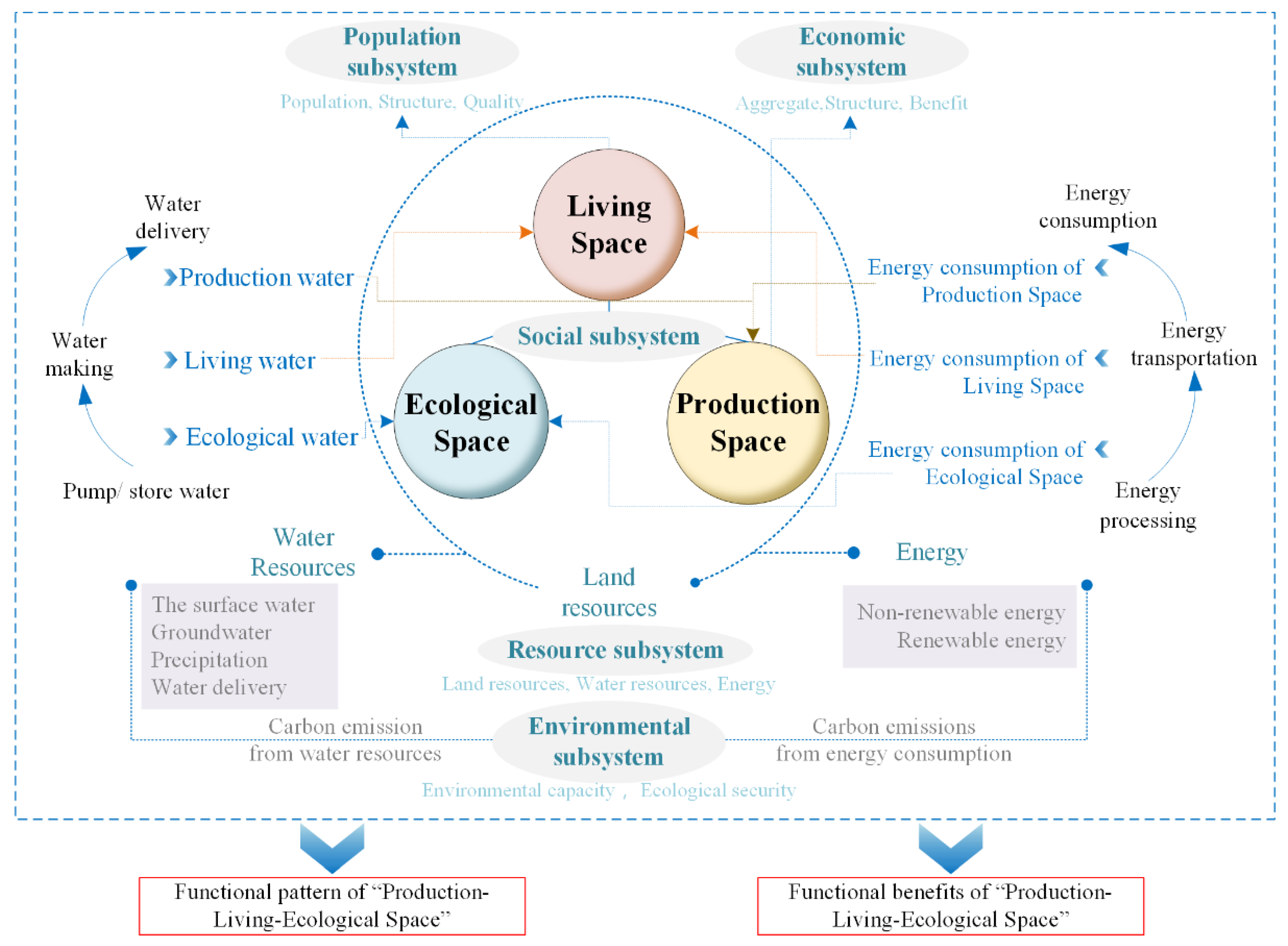
Planning for the national main functional area should represent the strategic background of basic planning in the future. Indeed, as the core means of spatial optimization at present, territorial spatial planning is an important part of the future national planning system. Moreover, PLES embodies the Chinese people’s vision for “future” development. This vision represents the final and most direct spatial carrier for the national strategy to penetrate into people’s livelihoods, and the ultimate optimization goal of planning implementation [86]. However, under the current strategic background of ecological civilization construction, there are many problems in the layout of “main function zones”, “territorial space planning”, and PLES. “Beautiful China” was a major strategic goal proposed at the 18th National Congress of the CPC, and represents a spatial carrier for realizing sustainable development of the Chinese nation, and enabling the Chinese people to enjoy better lives. To achieve the vision of “beautiful China”, the territorial and spatial patterns in the new era should be scientific and orderly, and remain in line with the processes of both modern and sustainable development. Based on analyzing the internal relationship between ecological civilization, beautiful China, and PLES, as well as the scientific connotations of PLES, the overall optimization system of PLES should be guided by the vision of building a beautiful China supported by the needs of national strategic applications, and centered on the human–Earth coupling system theory. By comprehensively considering the multi-dimensional coupling relationships between subsystems of the population, society, economy, resources, and the environment, as well as various elements within the system, a large, complex, dynamic, and open geographical system can be formed (Figure 1).
The overall optimization system of PLES includes the resource subsystem, population subsystem, social subsystem, economic subsystem, and environmental subsystem. Among them, the resource subsystem includes land resources, water resources, and energy. As the main carrier of future spatial planning, land resources are the core of PLES optimization. From the perspective of function, land resources can be divided into PLES. PLES has the characteristics of differences in spatial scale, functional complexity, and dynamic scope. Under different spatial scales and time nodes, the same territorial space can feature different, or even overlapping, properties of PLES [86]. Living space mainly functions as living land, providing resource support for population subsystems, and guaranteeing living needs. Production space mainly functions as production land, providing resource input for the economic subsystem, and meeting regional production demands. Ecological space mainly functions as ecological land, which provides ecological environment security maintenance capabilities for the environmental subsystem. As a compound land with multiple functions, public resources provide services for the resource supply, management, substitution, and compensation of social subsystems. In the process of land resource utilization, the population, society, and economic subsystem are also accompanied by the utilization of water resources and energy. The utilization of water resources includes production water for the agricultural and service industries, domestic water for urban and rural areas, and ecological water. Energy utilization includes production space energy consumption, living-space energy consumption, and ecological-space energy consumption. In the resource subsystem, land resources, water resources, and energy are interrelated through different avenues that, together, constitute the resource basis for the utilization and development of PLES. The different utilization modes, industrial structures, and development degrees of PLES determine the intensity of regional carbon emissions caused by the different quantitative methods of mutual demand between water, soil, and energy elements [87]. Therefore, constraints such as boundaries, red lines, and standards of land resources, water resources, energy, and carbon emissions should be taken into consideration in the overall optimization system for PLES.
Optimizing the quantitative structure and spatial layout of PLES based on water–land–energy–carbon constraints solves the problem of the pattern level of PLES. However, this optimization only reflects the application of the national strategy in territorial space optimization, and does not express people’s demands for high standards of living, production, and ecological and environmental safety, which would involve solving the qualitative level of PLES. In the Evaluation Index System and Implementation Plan for the Construction of a Beautiful China issued by the National Development and Reform Commission on 28 February 2020 [88], 22 indicators in the five categories of fresh air, clean water, safe soil, good ecology, and clean living were used to evaluate the construction of a beautiful China. These indicators are a direct reflection of the production environment, ecological environment, and living environment in the overall optimization system of PLES. Therefore, the evaluation results for the construction of a beautiful China will directly test the qualities and benefits of the overall optimization of PLES in order to realize the overall optimization of PLES under the dual constraints of patterns and benefits.
5. Conclusions and Future Prospects
By analyzing the internal relationship between ecological civilization, beautiful China, and PLES, as well as the scientific connotations of PLES, this paper systematically organized the optimization theory, methods, and practices for PLES around territorial spatial planning, with the overall planning of PLES as the goal, and the promotion of ecological civilization construction as the starting point. We also proposed an optimization approach for PLES. Based on the analysis and summary, the main research directions for the overall optimization of PLES in the future should include the following:
(1) Research on the main regional types and differentiation rules of PLES: This paper studied the distribution characteristics of the functional spatial patterns of PLES at multiple scales. In this way, the scale differences and functional complexities of PLES under different spatial scales were clarified. Moreover, classification and identification systems for PLES under different scales and different regional types were established.
(2) Analysis and research on the evolution process, structural characteristics, and development trends of PLES: The dynamic spatial and temporal evolution characteristics of the structural proportion and spatial scale of PLES were analyzed, including regional suitability and carrying capacity evaluation, regional differences in space, and development over time. Moreover, the coupling coordination degree and conflict mechanism in the evolutionary process of PLES were revealed.
(3) Analysis of the internal nonlinear mechanism for the PLES System: Guided by the theory of the human–Earth system, we revealed the competition and synergistic interactions and positive feedback mechanisms between population, resources, ecology, environment, and economic and social development in the PLES system, and identified the nonlinear dynamic effects among subsystems and elements in the system.
(4) Analysis of the mechanism for matter and energy transfer in the overall optimization system of PLES: Based on the regional resource metabolism theory and the geographical patterns of PLES, we deeply analyzed the transfer path, flow process, and metabolic mechanisms of key elements, such as water, soil, energy, and carbon, in the co-evolution process of PLES.
(5) Development and application of a simulation model and multi-objective optimization model for the overall optimization system of PLES: Studies should make full use of the research results for the nonlinear dynamic mechanisms, transmission paths, and flow processes of key elements in the PLES system, and carry out research on overall optimization strategies and scenario predictions for PLES in different regions, at different scales, and for different types.
(6) Research, development, and application of the overall optimization and decision support platform for PLES: A visual support platform was developed with integrated functions for data processing, spatio-temporal analysis, scenario simulation, result output, problem diagnosis, and early warning and control. This platform can help coordinate the government at all levels, and between different departments and different areas of the target demand, to facilitate population migration, urban and rural construction and industrial development, resource development, ecological construction, environmental protection, infrastructure construction, public services and disaster prevention, and mitigation-system spatial deployment as components of unified and consensus development goals and plans.
Author Contributions
G.L. and J.F. contributed to all aspects of this work; D.J. conducted data analysis; and G.L. and Y.Z. wrote the main manuscript text. All authors reviewed the manuscript. All authors have read and agreed to the published version of the manuscript.
Funding
This work was supported by grants from the Strategic Priority Research Program of the Chinese Academy of Sciences (Grant No. XDA19040305), Youth Innovation Promotion Association (Grant No. 2018068), and Institute of Geographical Sciences and Natural Resources Research, Chinese Academy of Sciences (Grant No. E0V00112YZ).
Institutional Review Board Statement
Not applicable.
Informed Consent Statement
Not applicable.
Data Availability Statement
The data presented in this study are available on request from the author.
Conflicts of Interest
The authors declare no conflict of interest.
References
- Li, S.D.; Liu, M.C.; Chen, Y.F. Beautiful Ecology: Theoretical Exploration Index Evaluation and Development Strategy, 3rd ed.; Beijing Science Press: Beijing, China, 2017. [Google Scholar]
- Wang, Q.M. The development path of ecological civilization. QIUSHI 2008, 3, 43–44. [Google Scholar]
- Xue, X.F. Accelerating ecological progress. West J. 2013, 15–16, 26. [Google Scholar]
- Chen, Y.W.; Mai, J.M. Adhere to the harmonious coexistence of human and nature, accelerate the construction of green modern landscape city. China Ecol. Civiliz. 2017, S1, 6–9. [Google Scholar]
- Gao, F.; Zhao, X.Y.; Song, X.Y.; Wang, B.; Wang, P.L.; Niu, Y.B.; Wang, W.J.; Huang, C.L. Connotation and Evaluation Index System of Beautiful China for SDGs. Adv. Earth Sci. 2019, 34, 75–85. [Google Scholar]
- Huang, J.C.; Lin, H.X.; Qi, X.X. A literature review on optimization of spatial development pattern based on ecological-production-living space. Prog. Geogr. 2017, 36, 378–391. [Google Scholar]
- Lu, D.F.; Jiang, M.Q. Features, logical relations and optimizing strategies of urban “Production-living-ecological space”. Hebei Acad. J. 2019, 39, 156–166. [Google Scholar]
- Xu, D.X. Social production and ecological environment in human life. J. Guangxi Norm. Univ. Philos. Soc. Sci. Ed. 1984, 4, 3–11. [Google Scholar]
- Zhang, C.G.; Fang, C.L. Driving mechanism analysis of ecological-economic-social capacity interactions in oasis systems of arid lands. J. Nat. Resour. 2002, 17, 181–187. [Google Scholar]
- Fang, C.L. The Scientific Basis and Systematic Framework of the Optimization of Chinese Urban Development Pattern. Econ. Geogr. 2013, 33, 1–9. [Google Scholar]
- Li, W. A Study on Theoretic Methods and Application of the Evaluation and Optimization of County Land Space. Ph.D. Dissertation, Fujian Normal University, Fuzhou, China, 2018. [Google Scholar]
- Wu, Z.Y. Space optimization of "Production-living-ecological" and ecological environment protection of Beijing, Tianjin and Hebei. City 2014, 12, 26–29. [Google Scholar]
- Zhu, Y.Y.; Yu, B.; Zeng, J.X.; Han, Y. Spatial Optimization from Three Spaces of Production, Living and Ecology in National Restricted Zones—A Case Study of Wufeng County in Hubei Province. Econ. Geogr. 2015, 35, 26–32. [Google Scholar]
- Fu, X.; Wang, X.; Zhou, J.; Ma, J. Optimizing the Production-Living-Ecological Space for Reducing the Ecosystem Services Deficit. Land 2021, 10, 1001. [Google Scholar] [CrossRef]
- Cao, X.S. Geogovernance of national land use based on coupled human and natural systems. J. Nat. Resour. 2019, 34, 2051–2059. [Google Scholar] [CrossRef]
- LI, G.D.; Fang, C.L. Quantitative function identification and analysis of urban ecological-production-living spaces. Acta Geogr. Sin. 2016, 71, 49–65. [Google Scholar]
- Liu, D.P. Thinking on the demarcation of “Production-living-ecological space” in urban and rural planning. Anhui Archit. 2021, 28, 38–39. [Google Scholar]
- Yang, X.J.; Zhao, B.Y.; Li, M.L. Rural construction planning at county level based on “Production-living-ecological space” coordinated development: A case study of Pinglu County, Shanxi Province. China Anc. City 2021, 35, 66–74. [Google Scholar]
- Kates, R.W.; Clark, W.C.; Corell, R.; Hall, J.M.; Svedlin, U. Environment and development—Sustainability science. Science 2001, 292, 641–642. [Google Scholar] [CrossRef]
- Ge, Y.C.; Ge, D.B. Ecological spatial distribution based on ecological suitability: A case study of Xiangyin County, Yueyang City. J. Northeast Agric. Sci. 2021, 46, 120–124. [Google Scholar]
- Hu, W.T.; Wang, L.G.; Shu, M.H. Reflections on Delimiting the Three Basic Spaces in the Compilation of Urban and Plans. City Plan. Rev. 2016, 40, 21–26. [Google Scholar]
- Ma, Y.Y. The Study on the Optimization of “Production-Living-Ecological” Space in Puge County. Master’s Dissertation, Sichuan Normal University, Chengdu, China, 2017. [Google Scholar]
- Liao, G.T.; He, P.; Gao, X.S.; Deng, L.J.; Zhang, H.; Feng, N.N.; Zhou, W.; Deng, O.P. The Production–Living–Ecological Land Classification System and Its Characteristics in the Hilly Area of Sichuan Province, Southwest China Based on Identification of the Main Functions. Sustainability 2019, 11, 1600. [Google Scholar] [CrossRef] [Green Version]
- Zhang, H.Q.; Xu, E.Q.; Zhu, H.Y. An ecological-living-industrial land classification system and its spatial distribution in China. Resour. Sci. 2015, 37, 1332–1338. [Google Scholar]
- Gou, M.M.; Liu, C.F.; Li, L.; Xiao, W.F.; Wang, N.; Hu, J.W. Ecosystem service value effects of the Three Gorges Reservoir Area land use transformation under the perspective of “production-living-ecological space”. Chin. J. Appl. Ecol. 2021, 32, 3933–3941. [Google Scholar]
- Zhou, J.X.; Zhang, Q.J. Study on the Relationship between Land Use Transformation and Ecological Environment Change in Tianjin Based on “Ecological-production-living Spaces”. J. Tianjin Chengjian Univ. 2021, 27, 333–339. [Google Scholar]
- Wang, R.J.; Zhao, X.M.; Guo, X.; Ye, Y.C.; Li, Y.; Zhou, Y. A Study on Land Use Transformation and Ecological Environment Effects fromthe Perspective of "Production-Living-Ecological Space”: A Case Study of Yingtan City, Jiangxi Province. Acta Agric. Univ. Jiangxiensis 2021, 43, 681–693. [Google Scholar]
- Liu, J.L.; Liu, Y.S.; Li, Y.R. Classification evaluation and spatial-temporal analysis of "production-living-ecological" spaces in China. Acta Geogr. Sin. 2017, 72, 1290–1304. [Google Scholar]
- Cheng, T.; Zhao, R.; Liang, Y. Production- living -ecological Space Classification and Its Functionzl Evaluation. Remote Sens. Inf. 2018, 33, 118–125. [Google Scholar]
- Jin, G. Study on Comprehensive Function Regionalization of National Spatial Territory. Ph.D. Dissertation, China University of Geosciences, Wuhan, China, 2014. [Google Scholar]
- Chen, L.; Zhou, S.L.; Zhou, B.B.; Gang, L.L.; Chang, T. Characteristics and Driving Forces of Regional Land Use Transition Based on the Leading Function Classification: A Case Study of Jiangsu Province. Econ. Geogr. 2015, 35, 155–162. [Google Scholar]
- Liu, Y.; Shi, D.; Wang, J. Recognition and analysis of Sansheng space function in tourist towns—Taking Erdaobaihe Town Changbai Mountain, Jilin Province as an example. Jiangsu Agric. Sci. 2021, 49, 201–206. [Google Scholar]
- Zhang, C.; Zhang, Y.B.; Chen, S.; Yang, L.H. Identification and Evaluation of Development Patterns of Small Towns in Hebei Province: A Functional Perspective of Production, Living and Ecology. J. Hebei Univ. Technol. Soc. Sci. Ed. 2021, 13, 16–24. [Google Scholar]
- Huang, S.Q.; Xi, F.R.; Chen, Y.M.; Gao, M.; Pan, X.; Ren, C. Land Use Optimization and Simulation of Low-Carbon-Oriented—A Case Study of Jinhua, China. Land 2021, 10, 1020. [Google Scholar] [CrossRef]
- Zhang, J.; Chen, Y.; Zhu, C.M.; Huang, B.B.; Gan, M.Y. Identification of Potential Land-Use Conflicts between Agricultural and Ecological Space in an Ecologically Fragile Area of Southeastern China. Land 2021, 10, 1011. [Google Scholar] [CrossRef]
- Li, B.; Yang, C.X.; Xie, D.L.; Luo, Y.Z.; Li, Y.T. Analysis of Spatiotemporal Evolution Characteristics of ‘Sansheng’ Function in Hilly Areas—A Case Study of Jiangjin District of Chongqing. Res. Soil Water Conserv. 2021, 28, 316–323. [Google Scholar]
- Guo, R.; Zhao, Y.W.; Song, X.Y.; Aihemaiti, N.M.T. Identification and layout of Production-living-ecological Space based on POI data: A case study of Qingdao city. In Proceedings of the 2020/2021 China Urban Planning Annual Conference and 2021 China Urban Planning Academic Season Chengdu 2021, Chengdu, China, 25 September 2021; pp. 881–888. (In Chinese). [Google Scholar]
- Cao, G.R.; Gu, C.L.; Zhang, Q.Y. Recognition of “Ecological Space, Living Space, and Production Space” in Urban Central Area Based on POI Data: The Case of Shanghai. Production 2019, 2, 44–53. [Google Scholar]
- Ye, W.H. Building a healthy society by coordinating ecology, life and production for ecological civilization. J. Wuhan Univ. Sci. Technol. Soc. Sci. Ed. 2010, 12, 7–10. [Google Scholar]
- Tian, D.Q.; Wang, Q.; Ye, W.H. Common development of life, production and environment: Basic goal and behavior norms of sustainable development. China population. Resour. Environ. 2004, 14, 8–11. [Google Scholar]
- Gao, S.; Zhu, D.L.; Hu, H.L. Water Environment Comprehensive Management of Small Watershed Based on Common Development of Life, Production and Environment. Chin. J. Environ. Manag. 2017, 9, 52–56. [Google Scholar]
- Gu, C.L. Scientific Planning of “Production-Living-Ecological Space” Elements under the Land Space Planning System. CIYEW.COM. Available online: https://www.ciyew.com/policy/0637-4238.html (accessed on 7 October 2019).
- Bossel, H. Indicators for Sustainable Development: Theory, Method, Applications: A Report to the Balaton Group; International Institute for Sustainable Development (IISD): Winnipeg, MB, Canada; Institut International du Développment Durable: Vernier, Switzerland, 1999. [Google Scholar]
- Wang, F. Philosophical Thinking on sustainable development strategy. Theory Horiz. 2002, 5, 7–8. [Google Scholar]
- Wu, C.J. On the research core of geography—The regional system of man earth relationship. Econ. Geogr. 1991, 3, 7–12. [Google Scholar]
- Lu, D.D. Theoretical studies of man-land system as the core of geographical science. Geogr. Res. 2002, 21, 135–145. [Google Scholar]
- Liu, J.G.; Dietz, T.; Carpenter, S.R.; Alberti, M.; Folke, C.; Moran, E.; Pell, A.N.; Deadman, P.; Kratz, T.; Lubchenco, J. Complexity of coupled human and natural systems. Science 2007, 317, 1513–1516. [Google Scholar] [CrossRef] [Green Version]
- Liu, J.G.; Dietz, T.; Carpenter, S.R.; Folke, C.; Trade, S. Coupled Human and Natural Systems. AMBIO J. Hum. Environ. 2007, 36, 639–649. [Google Scholar] [CrossRef]
- Liu, T.; Hou, L.G. Spatial-temporal evolution characteristics of the production-living-ecological spatial function coupling coordination in the western Sichuan urban agglomeration. Hubei Agric. Sci. 2021, 60, 76–83. [Google Scholar]
- Niu, Y.X.; Wu, S.X.; Guo, C.Y.; Zhuang, Q.W.; Xie, C.H.; Zhang, Z.H.; Luo, G.P. Analysis on the spatio-temporal changes and coupling coordination of the function of “production-living-ecological” in Xinjiang. Arid Land Geogr. 2021, 44, 1–21. Available online: http://kns.cnki.net/kcms/detail/65.1103.X.20210622.1109.002.html (accessed on 20 October 2021).
- Mao, H.Y. Theories and methods of optimal control of human-earth system: Commemoration of 100th anniversary of Academician Wu Chuanjun’s birth. Acta Geogr. Sin. 2018, 73, 608–619. [Google Scholar]
- Von Bertalanffy, L. The History and Status of General Systems Theory. Acad. Manag. J. 1972, 15, 407–426. [Google Scholar]
- Zhang, X.J. The Elements, Structure and Model of Smart City System. Ph.D. Dissertation, South China University of Technology, Guangzhou, China, 2015. [Google Scholar]
- Zhang, Y.Y.; Cheng, M.J. Spatial Systematic Cognition and Ideas on Spatial Planning System Reform. China Land Sci. 2016, 30, 11–21. [Google Scholar]
- Ma, S.F.; Huang, H.Y.; Cai, Y.M.; Nian, P.H. Theoretical Framework with Regard to Comprehensive Sub-Areas of China’s Land Spaces Based on the Functional Optimization of Production, Life and Ecology. Nat. Resour. Econ. China 2014, 27, 31–34. [Google Scholar]
- Chen, H.; Yang, Q.; Su, K.; Zhang, H.; Lu, D.; Xiang, H.; Zhou, L. Identification and Optimization of Production-Living-Ecological Space in an Ecological Foundation Area in the Upper Reaches of the Yangtze River: A Case Study of Jiangjin District of Chongqing, China. Land 2021, 10, 863. [Google Scholar] [CrossRef]
- Li, J.S.; Sun, W.; Yu, J.H. Change and regional differences of production-living-ecological space in the Yellow River Basin: Based on comparative analysis of resource-based and non-resource-based cities. Resour. Sci. 2020, 42, 2285–2299. [Google Scholar] [CrossRef]
- Du, L.Z.; Yang, W.W. Multi-functional Evaluation and Zoning Optimization in Rural Areas under the Perspective of “Sansheng Spaces”: Taking Heilongjiang Province as an Example. Archit. Cult. 2021, 8, 258–261. [Google Scholar]
- Zhang, Y.Z.; Zhang, J.L.; Cheng, Y.; Ren, J.L. Study on the Meaning of Space Balance and Condition Assessment from the Perspective of Supply and Demand Driven—A Case of Shandong Province. Soft Sci. 2016, 30, 54–58. [Google Scholar]
- Bauman, Z. Community: Seeking Safety in an Insecure World. Contemp. Sociol. 2001, 31, 442. [Google Scholar] [CrossRef]
- Hu, X.D. Production, Living and Ecological Space Based on Human Settlements in Reclation Area of Coal Min. Master’s Dissertation, China University of Geosciences, Beijing, China, 2016. [Google Scholar]
- Ding, C.Y.; Tang, G.N.; Ji, Y.N.; Sun, Y.P. Study on the integrated development of “Production-living-Ecological Space” in beautiful countryside -- A case study of Zhejiang Province. Rural Sci. Technol. 2021, 12, 99–103. [Google Scholar]
- Zhang, C.W.; Chen, K.Q.; Guo, Y.W.; Wang, D.; Zhao, B.B.; Wu, Y. Evaluating livability of urban space with consideration of the interactive characteristics of ecological-living-productive spaces: A case of Wuhan city. Bull. Surv. Mapp. 2021, 1, 124–129. [Google Scholar]
- Zhang, X.S.; Xu, Z.J. Spatial Temporal Evolution of Functional Coupling Coordination Degree of Production-Living-Ecological Space and Its Relationship with Human Activity Intensity in Ethnic Minority Areas—Taking Minority Autonomous Prefecture of Guizhou as an Example. Res. Soil Water Conserv. 2021, 28, 268–273. [Google Scholar]
- Li, Z.Y.; Li, Y.Y.; Wang, L.; Pei, Y.L. Study on the Functional Characteristics and Division Optimization of “Production-Living-Ecological” of Geographical Space in Yunnan Province. Ecol. Econ. 2021, 37, 94–101. [Google Scholar]
- Zhang, J.X. Assessment of land space utilization quality and its coupling and coordination based on producing, living and ecological—A case study of the southern Jiangsu Region. J. Agric. Sci. 2017, 38, 57–63. [Google Scholar]
- Wang, D.; Jiang, D.; Fu, J.Y.; Lin, G.; Zhang, J.L. Comprehensive Assessment of Production–Living–Ecological Space Based on the Coupling Coordination Degree Model. Sustainability 2020, 12, 2009. [Google Scholar] [CrossRef] [Green Version]
- Dong, G.; Ge, Y.; Jia, H.; Sun, C.Z.; Pan, S.Y. Land Use Multi-Suitability, Land Resource Scarcity and Diversity of Human Needs: A New Framework for Land Use Conflict Identification. Land 2021, 10, 1003. [Google Scholar] [CrossRef]
- Li, Q.Y.; Fang, C.L.; Wang, S.J. Evaluation of Territorial Utilization Quality in China: Based on the Aspect of Production-Living-Ecological Space. Areal Res. Dev. 2016, 35, 163–169. [Google Scholar]
- Zhang, L.; Cheng, X.Q.; Dong, X.C.; Ma, C.Q.; Wang, Y.X. Research on Spatial Layout Optimization of Industrial Land Based on Mutual Exclusion of Ecological-Production-Living Spaces in Tianjin. Geogr. Geo-Inf. Sci. 2019, 35, 112–119. [Google Scholar]
- Lin, G.; Jiang, D.; Fu, J.Y.; Cao, C.L.; Zhang, D.W. Spatial Conflict of Production-Living-Ecological Space and Sustainable-Development Scenario Simulation in Yangtze River Delta Agglomerations. Sustainability 2020, 12, 2175. [Google Scholar] [CrossRef] [Green Version]
- Yang, C.M.; Xu, X.F.; Zhang, H.; Hu, Y.G. Evolution and Optimization Features of Rural Residential Areas Based on ‘the Functions of Production-living-ecological Spaces’ in Shanghai. Resour. Environ. Yangtze Basin 2021, 30, 2392–2404. [Google Scholar]
- Lin, X.H.; Wang, Y. Study on the Strategy of Village Space Optimization in Xunwu County of Jiangxi Province against the Background of Rural Vitalization Strategy. Subtrop. Soil Water Conserv. 2021, 33, 5–10. [Google Scholar]
- Yang, H. Study on the Suitability Evaluation and the Optimization of “Production-Living-Ecological” Space-Taking Yangzhong for Example. Master’s Dissertation, Nanjing Normal University, Nanjing, China, 2018. [Google Scholar]
- Cheng, X.Q. A Study on the Delimitation of Resilient Ecological Space of Land Based on the Game of “Production-Living-Ecological”. Master’s Dissertation, Tianjin Polytechnic University, Tianjin, China, 2019. [Google Scholar]
- Zhou, L.Q. The Study on the Optimization and Function Improvement of “Ecological-Production-Living” Space in Zhengzhou. Master’s Dissertation, Zhengzhou University, Zhengzhou, China, 2018. [Google Scholar]
- Wang, S. Optimization of Territorial Development Patterns Based on Production-Living-Ecological Space of Xi’an City. Master’s Dissertation, Chang’an University, Xi’an, China, 2018. [Google Scholar]
- Tang, J.H.; Liu, C.W.; Wu, Y.X. A Study on Evaluation of Energy Consumption in China Based on NRCA Model. Econ. Geogr. 2011, 31, 1313–1318. [Google Scholar]
- Xu, L. Research on the Optimization of Geographical Spatial Pattern of Urban Agglomeration in the Middle Reaches of the Yangtze River Base on the Production-Living-Ecological Function. Ph.D. Dissertation, Huazhong Agricultural University, Wuhan, China, 2017. [Google Scholar]
- Wei, X.F.; Zhao, Y.L.; Li, X.B.; Xue, C.L.; Xia, S.Y. Characteristics and Optimization of Geographical Space in Urban Agglomeration in the Upper Reaches of the Yangtze River Based on the Function of “Production-Living-Ecological”. Resour. Environ. Yangtze Basin 2019, 28, 70–79. [Google Scholar]
- Lin, G.; Fu, J.; Jiang, D. Production–Living–Ecological Conflict Identification Using a Multiscale Integration Model Based on Spatial Suitability Analysis and Sustainable Development Evaluation: A Case Study of Ningbo, China. Land 2021, 10, 383. [Google Scholar] [CrossRef]
- Yuan, G.; Chen, W.B.; Yu, S.K.; Tang, S.L. A Study of Multi-scale Demarcation and Function Domination of the Production, Living and Ecological Space at County Level. Acta Agric. Univ. Jiangxiensis 2021, 43, 931–941. [Google Scholar]
- Xiao, R.; Shao, H.Y.; Li, F.; Xie, H.B. Classification evaluation and spatial-temporal pattern analysis of the “production-living-ecological spaces” in Sichuan province. Hubei Agric. Sci. 2021, 60, 146–152. [Google Scholar]
- Li, Q.; Luo, H.M.; Liu, C.X.; Yu, X.F.; Liu, Z.X. Study on Characteristics Evolution and Optimal Allocation of “Production-Living-Ecological Spaces” in Pearl River Delta Urban Agglomeration. Land Resour. Inf. 2021, 298, 126803. Available online: http://kns.cnki.net/kcms/detail/11.4479.n.20210918.0918.012.html (accessed on 2 November 2021).
- Zhang, D.; Ge, Q.S.; Zhang, X.Q.; Wu, S.H.; Yang, Q.Y. Regionalization in China: Retrospect and prospect. Geogr. Res. 2005, 24, 330–344. [Google Scholar]
- Wei, W.; Zhang, R. Exploration on the Optimization Path of Land Space Based on Main Functional Areas, Spatial Planning, and Three Living Spaces. Urban. Archit. 2019, 16, 45–51. [Google Scholar]
- Lai, X.J. Research on “production-living-ecological” spatial governance mode of Guangdong Province for “carbon peak and carbon neutral”. Real Estate World 2021, 13, 25–27. [Google Scholar]
- National Development and Reform Commission. Circular of the National Development and Reform Commission on Printing and Distributing Evaluation Index System and Implementation Plan of Beautiful China Construction. Fghz [2020] No. 296. 2020. Available online: https://www.ndrc.gov.cn/xxgk/zcfb/tz/202003/t20200306_1222531.html (accessed on 3 July 2020).
Figure 1.
Framework system for the overall optimization of PLES.

Publisher’s Note: MDPI stays neutral with regard to jurisdictional claims in published maps and institutional affiliations. |
© 2022 by the authors. Licensee MDPI, Basel, Switzerland. This article is an open access article distributed under the terms and conditions of the Creative Commons Attribution (CC BY) license (https://creativecommons.org/licenses/by/4.0/).
Share and Cite
MDPI and ACS Style
Lin, G.; Jiang, D.; Fu, J.; Zhao, Y. A Review on the Overall Optimization of Production–Living–Ecological Space: Theoretical Basis and Conceptual Framework. Land 2022, 11, 345. https://0-doi-org.brum.beds.ac.uk/10.3390/land11030345
AMA Style
Lin G, Jiang D, Fu J, Zhao Y. A Review on the Overall Optimization of Production–Living–Ecological Space: Theoretical Basis and Conceptual Framework. Land. 2022; 11(3):345. https://0-doi-org.brum.beds.ac.uk/10.3390/land11030345
Chicago/Turabian StyleLin, Gang, Dong Jiang, Jingying Fu, and Yi Zhao. 2022. "A Review on the Overall Optimization of Production–Living–Ecological Space: Theoretical Basis and Conceptual Framework" Land 11, no. 3: 345. https://0-doi-org.brum.beds.ac.uk/10.3390/land11030345
Note that from the first issue of 2016, this journal uses article numbers instead of page numbers. See further details here.