Case Report

Industrial Sprawl and Residential Housing: Exploring the Interplay between Local Development and Land-Use Change in the Valencian Community, Spain

1
Department of Agricultural and Forestry Sciences (DAFNE), Tuscia University, Via San Camillo de Lellis, I-01100 Viterbo, Italy
2
Soil Erosion and Degradation Research Group, Department of Geography, University of Valencia, ES-46010 Valencia, Spain
3
Department of Agriculture, University of Sassari, Viale Italia, I-07100 Sassari, Italy
4
Council for Agricultural Research and Economics (CREA), Viale S. Margherita 80, I-52100 Arezzo, Italy
*
Author to whom correspondence should be addressed.
Submission received: 30 July 2019 / Revised: 26 August 2019 / Accepted: 18 September 2019 / Published: 20 September 2019

Abstract

:
Urbanization in Mediterranean Europe has occurred in recent decades with expansion of residential, commercial and industrial settlements into rural landscapes outside the traditional metropolitan boundaries. Industrial expansion in peri-urban contexts was particularly intense in Southern Europe. Based on these premises, this work investigates residential and industrial settlement dynamics in the Valencian Community, Spain, between 2005 and 2015, with the aim to clarify the role of industrial expansion in total urban growth in a paradigmatic Mediterranean region. Since the early 1990s, the Valencian industrial sector developed in correspondence with already established industrial nodes, altering the surrounding rural landscape. Six variables (urban hierarchy, discontinuous settlements, pristine land under urban expansion, isolated industrial settlements, within- and out-of-plan industrial areas) were considered with the aim at exploring land-use change. Empirical results indicate a role of industrial development in pushing urban sprawl in coastal Valencia. A reflection on the distinctive evolution of residential and industrial settlements is essential for designing new planning measures for sustainable land management and containment of urban sprawl in Southern Europe. A comparative analysis of different alternatives of urban development based on quantitative assessment of land-use change provides guidelines for local development and ecological sustainability.

1. Introduction

Land-use has transformed substantially in recent decades since agricultural and forest areas have been replaced by urban settlements designated for both residence and industrial/commercial activities [1,2]. Such transformations were associated with distinctive socioeconomic contexts [3,4,5,6,7,8,9,10,11] and a progressive trend toward decentralization of population and industries [3,12,13]. In Europe, the recent expansion of industrial settlements was the result of multiple factors, including economic and financial globalization, national and local policies, societal changes, and new lifestyles [10,14]. Moreover, urbanization processes—especially those involving industrial settlements—have occurred in recent decades outside the traditional urban centers, settling new economic poles along peri-urban landscapes [4,7,15,16,17,18]. Along with residential sprawl [6,8,9,19,20], some metropolitan areas in Europe have witnessed a huge expansion of industrial settlements, increasing their degree of innovation and urban competitiveness [4,21,22,23]. However, new industrial settlements have been concentrated along the major roads of metropolitan regions, optimizing logistics, attractiveness and commercial relations with global markets [4,24,25]. The increasingly dispersed location pattern of economic activities—especially industry—in peri-urban regions have received particular attention in social sciences recently [26,27]. Positive externalities of proximity have been documented [28]. The notion of ‘Industrial Districts’ [29] or ‘Industrial Clusters’ [30] have been analyzed in the content and nature of these externalities. Firms participating in territorial-based networks have developed a set of relationships in the form of “untraded interdependencies”, which benefit their innovation and competitive capabilities in different aspects [31].
At the same time, the expansion of residential settlements in peri-urban Europe has also been investigated [4,8]. For instance, Southern European cities have extended into rural areas forming suburbs and residential sub-centers with medium-dense settlements mixed up with scattered and fragmented commercial areas [32,33,34,35]. In these contexts, spatially unbalanced settlements have expanded into rural areas through low-density suburbs and isolated residential settlements [36]. The legacy of the past development was replicated in the spatial configuration of several metropolitan regions in Southern Europe [10]. Weak planning regulations, ‘informal’ building activities and high costs of housing in central cities have played a major role in residential sprawl [33,37]. At the same time, processes underlying industrial sprawl in such contexts were only occasionally investigated and need a more comprehensive understanding to clarify the latent mechanisms underlying urban dispersion in the Mediterranean basin. The purpose of the present work is to investigate industrial and residential expansion of a Southern European city (Valencia, Spain). A mixed residential/industrial expansion was particularly evident in Valencia since the 1980s [38,39,40,41,42]. More recently, large industrial poles were established in peri-urban districts involving different economic sectors; for example, the car manufacturer in the Southern Valencia and ceramics in the province of Castellón [43]. The current industrial outline also changed the traditional landscape in Valencia, converting rural areas towards residential and industrial land-use [42].
Based on these premises, the present study assumes that spatial transformations in the Valencian Community have been strongly associated with economic specialization and social contexts [43,44]. In these regards it was demonstrated how urban expansion in the Southern Europe has frequently stimulated transformations towards (i) industrialization, (ii) economic specialization and (iii) innovation spillovers [31]. Such phenomena led to accelerated growth of residential and industrial settlements, giving job opportunities to people living in neighboring districts [4]. Exploring residential and industrial evolution in the last decade in relation with other land-use may suggest improved regional planning and sustainable management of peri-urban land. By reflecting on the recent residential and industrial evolution in a Spanish region, a comparative assessment of the interplay between local development and land-use changes may inform policies for urban containment under conditions of accelerated industrial development.

2. Material and Methods
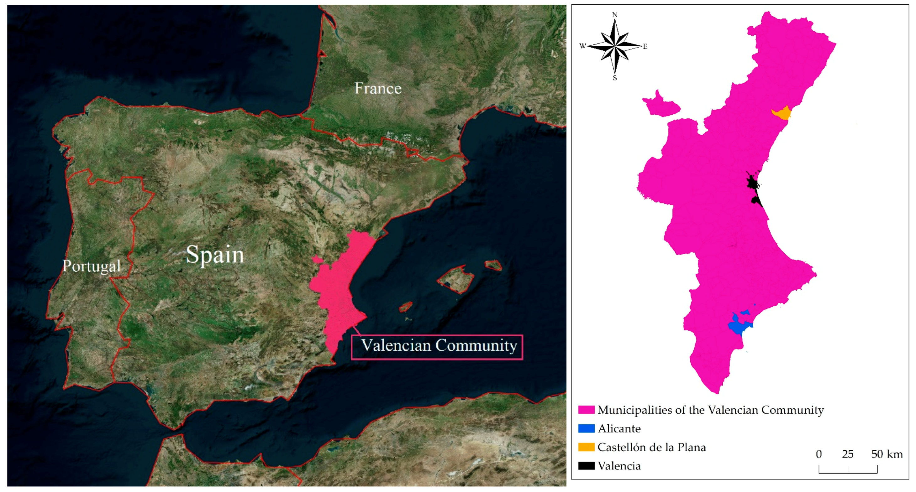
2.1. Case Study

With an area extending 23,255 km2 and hosting nearly five million inhabitants, the Valencian Community is one of the most dynamic regions of Spain [45], located in the eastern area of the Iberian Peninsula (Figure 1). Valencia, the capital city of the Valencian Community, is the third largest city in the country, with a metropolitan area populated by 1.5 million inhabitants. Besides Valencia, Castellon de la Plana and Alicante are the other two head towns of the region [38,46,47].
Being a typically Mediterranean region, Valencian Community has become a major tourist destination in recent decades [39,42], promoting its touristic image, especially the Costa Blanca destination in Alicante [39]. Its strategic position in the Mediterranean basin, mild climate and territorial diversity contribute to make the Valencian Community very attractive in every aspect and season [45], revealing its cultural and natural heritage, a diversified economic system, extended farmlands and highly qualified services in the tourism sector [42].
The Valencian Community has exhibited a particularly intense urban growth in recent years (48). In this region, suburbanization has affected not only major cities but also medium-sized towns, peri-urban areas and intermediate rural districts [48]. According to data derived from the Corine Land Cover European project, sealed soil area increased by 52.1% between the 1990s and the 2000s, a value above the national average. About 41.4% of this development came from urban areas, particularly those characterized by dispersed and low-density patterns. Consequently, discontinuous urban fabric grew by 48% and sparse urban structures by 103%, while compact urban fabric rose by 8.5% (following the statistics disseminated by Observatory of Sustainability in Spain in 2006).
In recent decades, the Valencian Community had experienced a rapid urban and economic growth centered on “commercial” attractiveness, with implications on landscape quality [45]. While residential settlements have spread along the seacoast, reflecting the expansion of second home housing markets [49,50,51,52], industrial activities have been more concentrated along the main road axes [53]. Recent urban developments have defined a new metropolitan corridor where the main urban centers provide a sparse countryside of houses, industrial parks and highways expanding into agricultural lands [42]. Such kind of outline designs a distinctive Spanish style of urban sprawl [3,54,55]. Counteracting a potential loss of landscape, the Valencian Community was the first Spanish region to be fully adherent with the objectives of the European Landscape Convention through the design and implementation of a set of policies and plans for the protection and enhancement of its landscapes [45].
The agreement of Spain’s democratic Constitution in 1978 instigated a process of political decentralization, basically changing legal bases and political drives overdue land-use planning [40,49]. Authority concerning the urban and regional planning was relocated from the Spanish capital city, Madrid, to the regions, like the Valencian Community. Therefore, regional governments endorse their regional economic development since decentralization transformed also the social background for planning and economic expansion [40]. Regional administrations were shaped and cities, as Valencia, turned out to be the regional capitals, occupied with new institutional and representational devices. The 1978 Constitution deputized select jurisdictional authority over urban planning to new regional administrations, like the Generalitat Valenciana; meanwhile, municipalities engaged important planning autonomy and regional government to have a certain planning role of territorial planning at the supra-municipal scale [40]. Though the scale of territorial planning is distinct and greater to that of traditional urban planning, both territorial and urban planning are essentially connected with a common devotion on land-use [40].
With the 1990–1992 Act during a social-democratic government, a modest effort to limit landownership rights gave more importance to public goals in the planning system [56]. In fact, the 1994 ‘urbanizing agents’ law has led to increased investment and urbanization in the context of public spatial planning throughout the Valencian Community. This event has directed real land-use changes in the planning practice of local authorities, industry development and land markets [57,58]. As a result of land speculation often derived from urban dispersion, landowners have built up a wealth of second homes and villas in peri-urban areas and near the seacoast. The 1994 law was applied to provide luxury infrastructure to these semi-consolidated and often underserved areas. The owners could build more and escape from the new infrastructure, though they were forced to pay for these benefits and to give up a significant part of their land [59]. However, such urbanization has transformed the landscape, as owners build second homes and villas with high land consumption [56,57,58,59,60].
However, the recent housing construction of second homes along the seacoast and dispersive urbanization happened thanks to direct involvement of the local and regional government [61,62]. In fact, Spanish municipalities have suffered from a shortage of financial resources due to the regional decentralization. As a result, local administrations have detected sprawl urbanization to raise their resources through land supervision and new housing taxes. They are consequently better fortified to face inhabitants’ demands and opportunities for the enhancement of services. The transaction fees connected to urbanization and land liberalization, together with local fiscal competences over housing construction, have offered both municipal and regional administrations with the resources needed to renovate cities [61,62]. Though, the restrictions of what modernization incomes have occasionally been blurred, to the extent that the housing boom became in some cases unreasonable, like in Southeastern Spain [8,20,37].

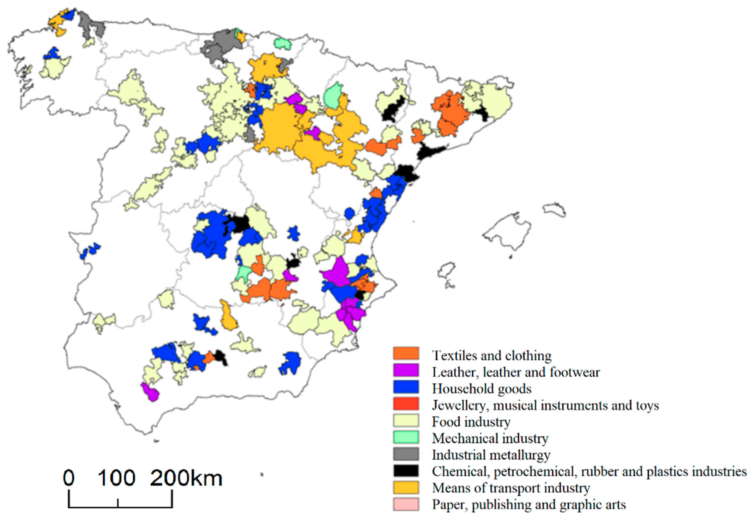
2.2. The Industrial Context

The Valencian Community has been the most investigated among the industrial districts of Spain (Figure 2), thanks to the role of industry in regional economy since the early 1980s [44,63,64]. The first industrial district of the region was in a municipal cluster specialized in the ceramic production in the province of Castellón, being likely the most studied local system in Spain [46,47,63,64,65,66].
The historical expansion of Valencia’s metropolitan area reflected the structural transformations arising from the industrialization process of the 1960s. In the 1970s, population and economic growth associated with industrialization were concentrated in the central municipality and in specific municipalities southwest of Valencia. In the 1980s, development took place mainly northwest of Valencia, as a result of industrial, residential and tertiary sector growth promoted by improvements in transport and communication infrastructures. Residential and economic decentralization started in the 1990s, giving rise to marked differences in land-use structures between the central municipality, where the tertiary sector was mainly located, and the metropolitan ring, where industry still prevails [67]. A small portion of the regional population (17%) settled in a low-density intermediate region in-between seacoast and mountains, concentrated along the main roads, where a predominance of medium-sized towns, industrial settlements and rain-fed agriculture dominate the landscape [60]. In this context, industrialization stimulated residential expansion.
Despite the 2007 recession, industrial specialization in Valencia was preserved in recent times, thanks to ceramic production [46]. However, industry in the last decade has lost importance in the Valencian economy. According to the data collected in the Spanish Regional Accounts, the manufacturing industry contributed 19.5% of regional Gross Value Added (GVA) in 2000, falling to 12.3% in 2009. The industrial decline was particularly intense in this period: Valencian industry accounted for 11.5% of Spanish industrial GVA in 2000 and only for 9.0% in 2009. In a decade, the productive structure of the Valencian Community has reduced its industrial specialization: the location quotient of the manufacturing industry decreased from 1.19 in 2000 to 1.09 in 2009. In 2011, the industrial GVA grew in a context of recession, with a share in the regional value added up to 13.3% [48]. Valencian industry has been negatively influenced by the 2008 crisis, to the extent that some of the traditional sectors are on the edge of extinction, especially furniture and glass manufacturing sectors. Other sectors seriously affected by global recession are the textile industry, clothing and toys. Conversely, the manufacture of ceramic products and the manufacture of rubber and plastics have better endured the recent crisis [48]. For instance, the existence of sub-networks of different relations within the ceramic district of Castellón gave a substantial resilience to the crisis, having promoted a spatial differentiation into a core network and a peripheral network with distinctive products and management, particularly in terms of share capital and innovation [46,47,65,66]. The ceramic industry emerged with a greater number of related firms in a bounded geographical area [27]. In Valencia, it is considered an example of ‘growth poles’ [68,69]. The ceramic cluster has maintained a dynamic trajectory and demonstrated a great adaptation to the crisis [45]. Even the textile industry is an important industrial district located in the province of both Alicante and Valencia, increasing considerably in recent years [44,70].

2.3. Indicators

Land-use data used in this study has been derived from the database of the Statistical and Cartographic institute of the Valencian Community (Table 1). Land-use maps were elaborated through photointerpretation on a set of ortho-photo-images at two distinctive years, 2005 and 2015. Land-use maps indicate that the landscape of Valencian Community is composed by more than 160,000 polygons of different land-use classes. For each polygon, the centroid was calculated as the most representative location. Polygon centroids are used widely in geographical studies [71,72] since they allow characterization of the spatial distribution of land-use in a definite region [73]. Each centroid was used to calculate the distance from the neighboring centroids [72]. Polygons were also profiled according to (i) the surface area, (ii) the perimeter and (iii) the mean elevation (using a Digital Terrain Model provided by the same data source); (iv) the ratio among surface area and perimeter of each land-use polygon; and (v) the name of the respective municipality.
For each land-use polygon, a spatial analysis was carried out to calculate other indicators assessing the linear distance from attractors such as (i) the seacoast, (ii) the neighboring major road, (iii) each of the three main cities in the region (Valencia, Castellon de la Plana and Alicante), (iv) each of the three main airports of the region, (v) the closest boundary of the neighboring statutory natural area and (vi) railway. The category “natural areas” included forests (e.g., deciduous forests and conifers), marshes, shrub, rocky outcrops, water system, as well as marine cliffs. Area designation followed the regional plan of protection of natural areas (Pla d’Ordenació de Recursos Naturals, PORN). Dummies were used to identify polygons belonging to (i) coastal municipalities, (ii) urban centers, (iii) discontinuous settlements, (iv) areas under urban expansion, (v) isolated industrial areas, (vi) planned industrial areas and, finally, (vii) out-of-plan industrial areas. Spatial analysis was carried out using Geographic Information Systems. Kernel density allowed us to calculate a magnitude per unit area from point features to fit a smoothly tapered surface to each point creating an output raster dataset with 1 km grid resolution. Descriptive statistics (average, minimum and maximum value, standard deviation and variance) were also calculated for each relevant variable.

2.4. Cluster Analysis
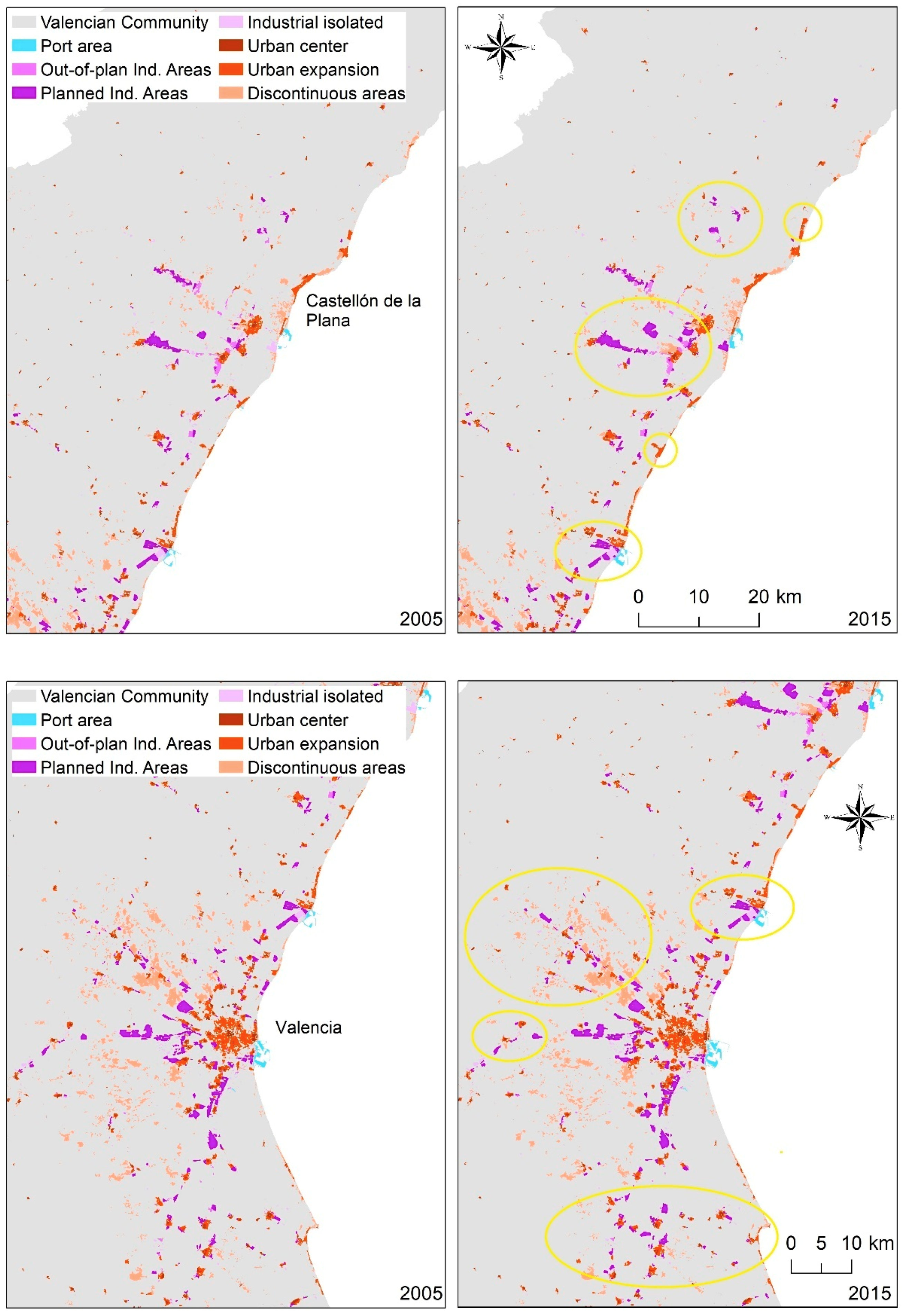
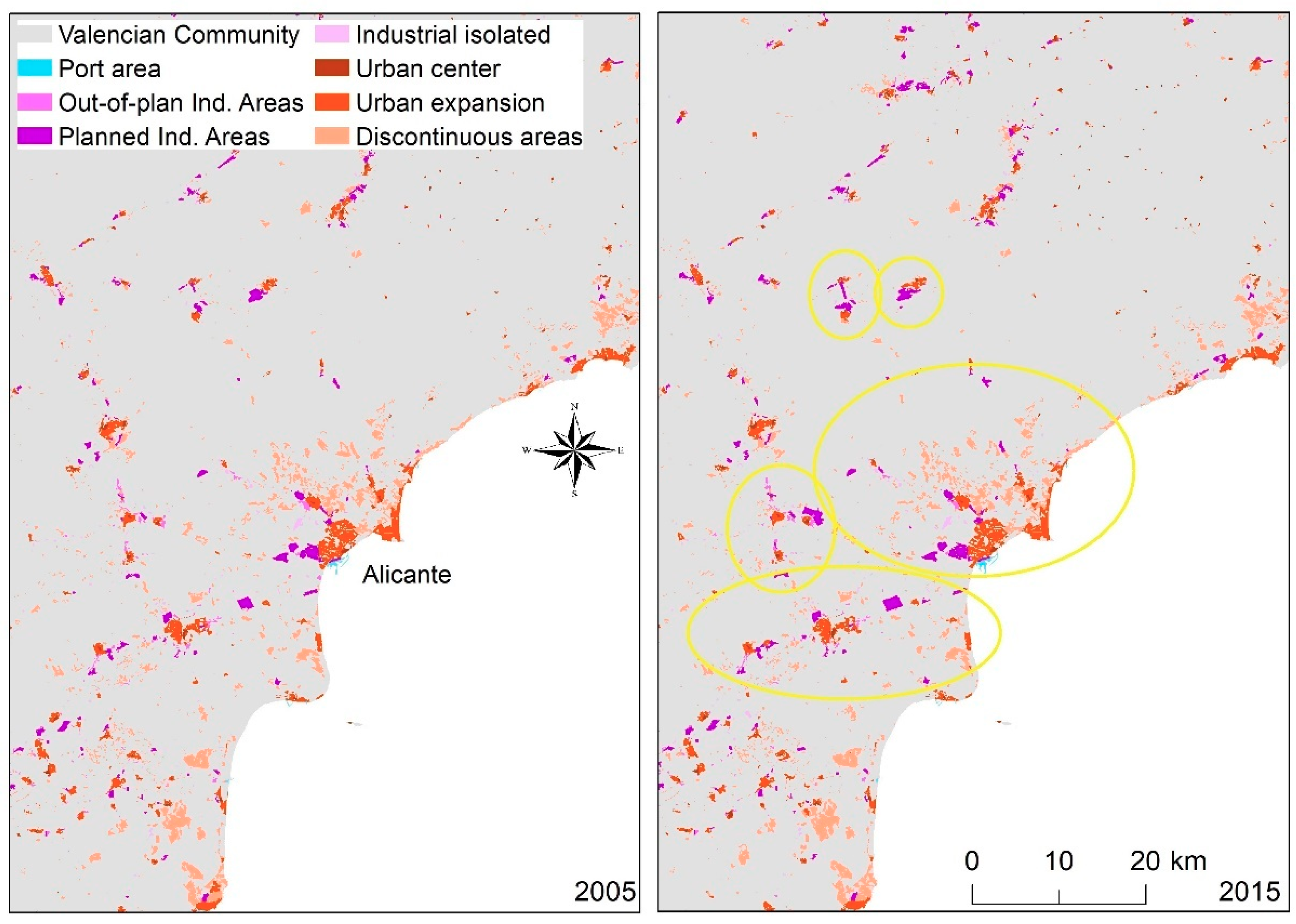
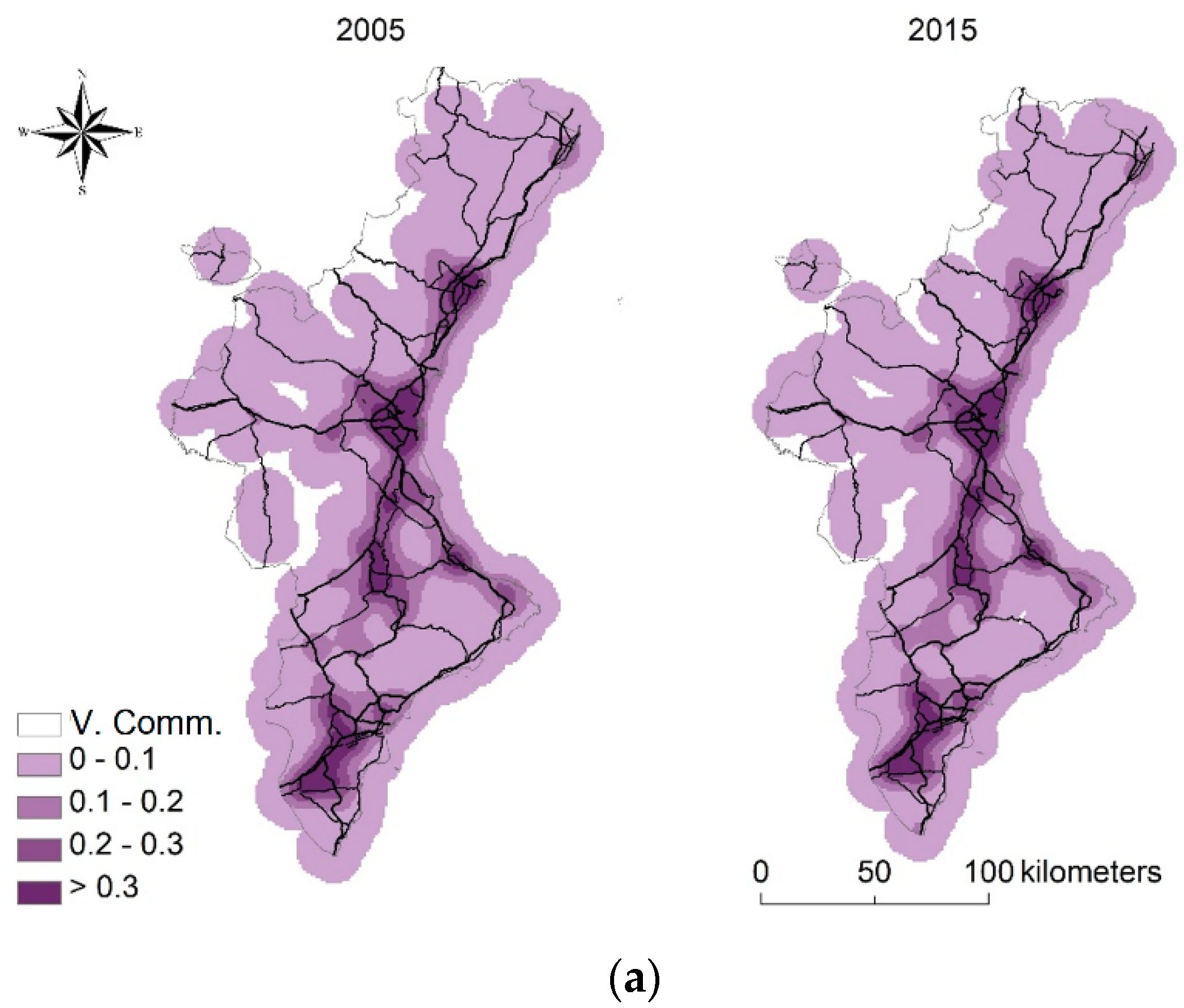
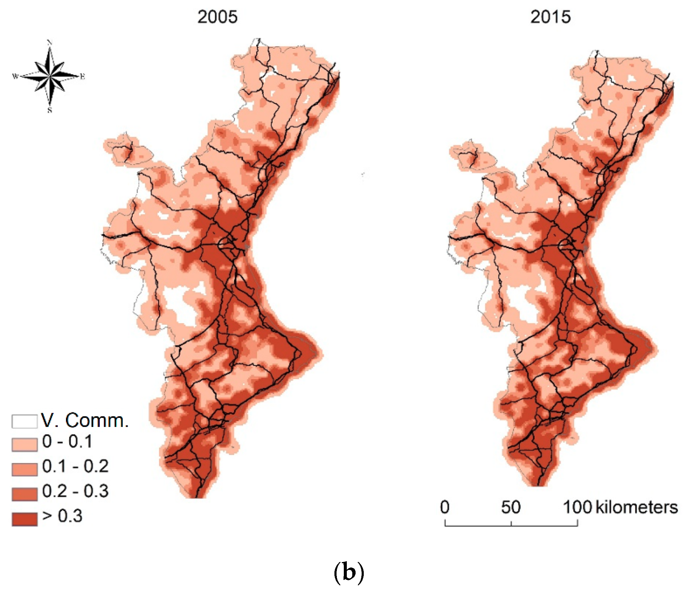
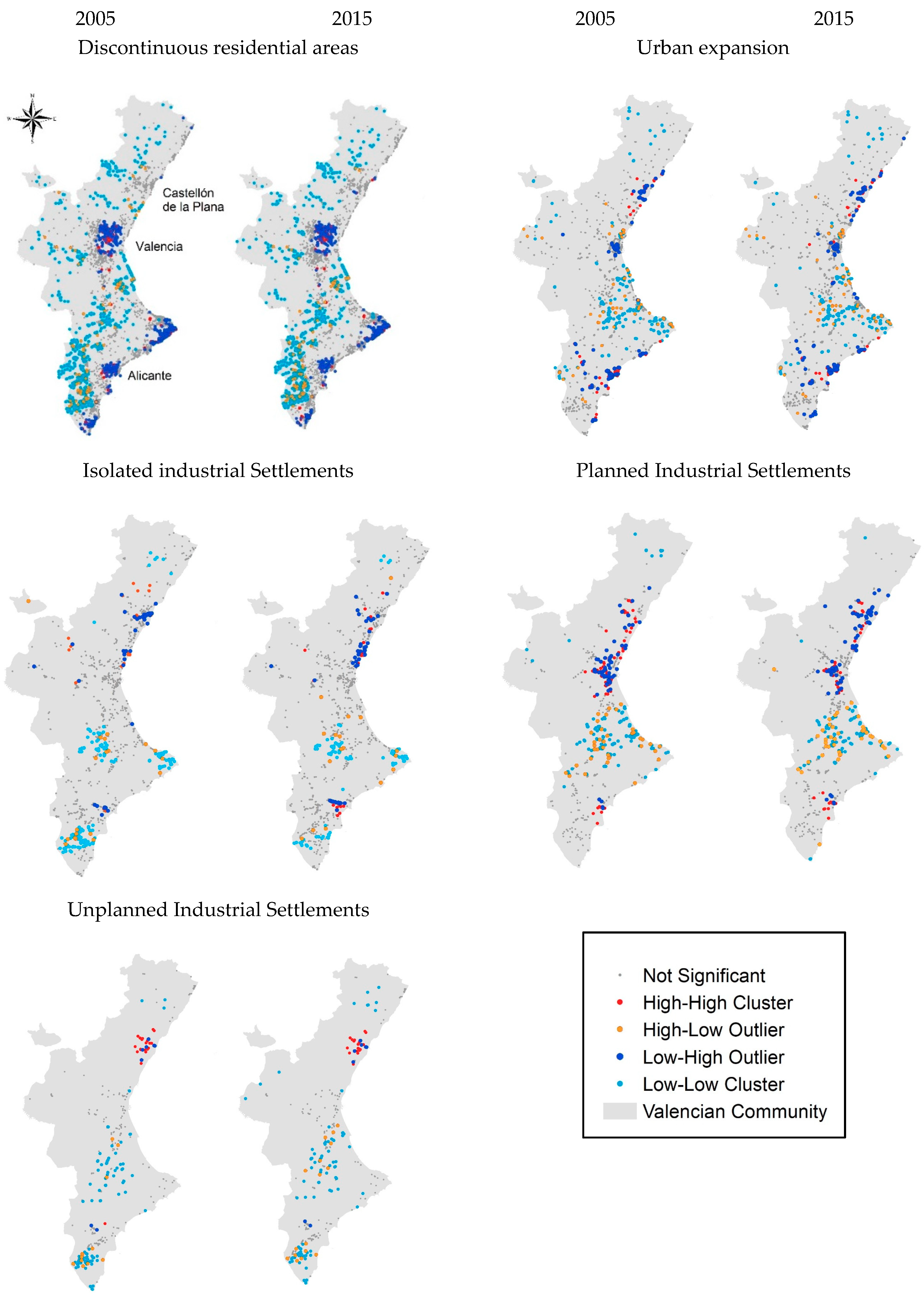
Clustering allowed identification of different types of land-use and their changes over time. Given a set of weighted features, a Cluster and Outlier Analysis (Anselin Local Moran’s I index) was run with the aim at identifying statistically significant spatial clusters and outliers. For each land-use class reported above, spatial analysis also explored how each cluster had transformed over time considering the relative surface area as a basic attribute.

3. Results

The analysis of polygon centroids falling in residential areas (urban center, discontinuous settlement and urban expansion) and industrial areas (industrial isolated, ordered industrial estate and unordered industrial estate) is illustrated in Table 2 separately for 2005 and 2015. The surface area for each land-use (‘sup_area’), the amount of industrial parcels (‘n_parc’), the average patch area (‘aver_parc’) and the related standard deviation (‘dev.stand_parc’) were calculated. Change over time in the surface area (‘Var_sup_1505’) and the absolute number of parcels (‘Var_n_1505’) was also calculated. Suburban areas, including discontinuous settlements and residential areas have strongly expanded between 2005 and 2015 (34%) although with a moderate fragmentation (12%). Isolated and out-of-plan industrial fabric decreased by 22% and 15%, respectively. Planned industrial areas have grown moderately (5%), similarly to settlements dispersed along the major economic poles and roads (12%).
Comparing residential and industrial land-use maps dated 2005 and 2015, both urban types expanded significantly over time (Figure 3). Metropolitan expansion was particularly evident in the case of dispersed urban settlements and planned industrial fabric.
Kernel analysis outlined different trends for industrial and residential land-use between 2005 and 2015 (Figure 4). First, industrial districts developed mainly along the motorways and main roads (Figure 4a). They seem to become more compact over time, particularly in the metropolitan area near Valencia. Industrial intensification took place near the major production centers and in correspondence with large urban centers. Unlike industrial settlements, residential development outlined a different trend where the highest density has concentrated over time along the coastal rim and, more slightly, along the main roads (Figure 4b).
Descriptive statistics (average, minimum and maximum value, standard deviation) were calculated for the distance between residential and industrial centroids from natural (protected) areas (Table 3). The lowest value was recorded for both discontinuous settlements and expanding urban areas, indicating a preference of sprawled settlements for locations close to natural amenities. The average distance from dispersed settlements decreased over time (from 765 m in 2005 to 718 m in 2015), indicating a subtle expansion of settlements towards natural areas. The greatest distance to natural locations was recorded for industrial areas, both informal and planned. Especially for unplanned sites, this distance decreased slightly from 1120 m (2005) to 1012 m (2015). This evidence indicates that industrial areas were settled relatively far from natural areas. At the same time, industrial areas were located far from residential areas. A specific pattern is evident for 2015, where isolated, planned and informal industrial estates were far from natural areas, 7.6, 22.3 and 2.8 km, respectively.
Analysis of spatial clusters identifies both residential and industrial settlements, classified into 4 sub-categories: (i) high–high cluster (red), when larger areas of a specific land-use are concentrated in areas similar in size and type of land-use; (ii) high–low outlier (orange), when larger areas of a given land-use type are concentrated around smaller areas of the same land-use; (iii) low–high outlier (dark blue), when smaller areas of a given land-use are concentrated in larger areas of the same land-use; (iv) low–low cluster (light blue), when smaller areas of a given land-use are concentrated in areas similar in size and type of land-use (Figure 5).
A greater dynamism was observed for the industrial settlements in the Valencian Community. In the area around Castellon, isolated industrial settlements expanded over time were classified as a low–high cluster. This outcome exhibited that small (isolated) industrial settlements tend to group over space following typical trends of larger industrial contexts. A similar trend also occurs in the area near Alicante. A divergent trend was instead recorded with low–low clusters, which seem to shrink over time, a pattern typical of the three light blue clusters identified in the southern area near Alicante. A strong dynamism is also evident for planned industrial areas. Particularly, fragmentation of industrial land was observed in the area of Castellon where the largest outlier in 2005 has turned into two distinct spatial outliers in 2015.
At the same time, high–high clusters emerged in the area of Alicante. Greater clusters and outliers have emerged for unplanned industrial estates. This trend was found in almost all areas, strengthening over time and concentrating in the spatial districts already evident for 2005. Concerning residential areas, several clusters define small plots of discontinuous land-use near larger residential areas (dark blue). This kind of cluster emerges in the cities of Valencia and Alicante, but also along the southern coastal area (Costa Blanca), between Denia and Benidorm. Moreover, this cluster does not vary significantly over time. Smaller and more isolated discontinuous residential areas are concentrated in the internal municipalities of the Valencian Community south of Valencia (light blue). Expanding areas strengthen clusters of this land-use class. In fact, the most evident clusters are located along the seacoast, particularly low–low clusters (light blue) between Valencia and Alicante.

4. Discussion

A half-century ago Valencia was a traditional Spanish provincial city entrenched economically and culturally in the surrounding croplands [42]. Nowadays the city has transformed rapidly [45], influencing the entire Valencian Community, promising a destination for tourists, and attracting trade and foreign investments [60,74]. In addition to the city of Valencia, the other two major cities, Alicante and Castellon de la Plana, have also expanded their metropolitan boundaries. For instance, while the economy of Alicante is based on a growing tourism sector, Castellon de la Plana has seen the birth of new and consolidated industrial districts in recent times [38,44,46,47,70].
The results of this study have outlined that residential development followed a different trend from industrial development in the Valencian Community. The highest residential density was concentrated along the seacoast, being spatially associated with the road system and decreasing along the urban–rural gradient. In contrast with the spatial pattern observed for residential settlements, industrial districts have developed especially along the major roads and railways. In fact, industrial areas have concentrated in the metropolitan area of Valencia, avoiding both mountainous and coastal locations. Moreover, the highest industrial density seems to overlap with the intermediate area designated by regional planning in Valencia [60]. A greater industrial intensification took place close to (i) the major production centers and (ii) the largest urban centers [75,76,77].
Descriptive statistics revealed a different relationship of residential and industrial development with natural areas. Discontinuous settlements and new compact urban areas designated for residential purposes were the results of suburbanization. These settlements were frequently located near the city and, in many cases, have replaced agricultural, forest and (protected) natural areas [6,78]. Conversely, industrial settlements resulted more distantly from natural areas. Their distance increased for both isolated and ordered industrial areas over time, decreasing for unplanned areas. The resulting outcome is a possible sign that, due to their potential risk for human health and environmental quality, industrial areas were preferentially located further away from natural areas. Reflecting on where locating residential or productive settlements is essential in prevention of potential risks to population and human activities in a given district [79]. Mediterranean contexts are sensitive to extreme episodes which affect economic activities and the inhabitants living in dispersed villages [78,80,81,82,83]. The presence of an industrial pole in areas classified at risk can cause socioeconomic damages and environmental disturbance [84,85].
Empirical results provide a better knowledge of a complex process of urban sprawl fueled by industrial development. Policymakers and decision-planners should consider specific requirements and threshold for implementing measures of sustainable land management [60,86]. Containment of urban sprawl is particularly required in risky areas dominated by industrial settlements. Land conversion to urban use should be allowed only in specific areas, considering criteria for sustainability and resilience, and taking example from earlier studies that demonstrate how sprawl affects land quality at the local scale [60]. In contrast with classical patterns of residential sprawl, industrial expansion has followed a precise spatial location depending on the road system, alternative to both coastal and internal natural locations. Analysis of land-use changes over time also demonstrated that residential development in the study area was limited and spatially coherent while an accelerated expansion of industrial settlements was noted together with strong location heterogeneity. More specifically, the Alicante context exposed similar production units forming an industrial cluster dominated by small enterprises. In Valencia, larger industrial areas were surrounded by smaller (satellite) areas. For planned industrial areas, a more evident spatial fragmentation was observed during the study period in Castellon where a large industrial district in 2005 was divided into two distinct outliers in 2015.
The spatial distribution of clusters and outliers has finally emerged for unplanned industrial settlements. This trend occurred in almost all districts and consolidated over time. Being the most studied economic district in Spain [46,47,61,62,63,64,65], the industrial context of Castellón emerged with Moran’s clustering. In this area, isolated industrial settlements expanded rapidly over time, ensuing a low–high clustering. These results indicate that small (isolated) industrial contexts tend to cluster after a sufficiently long time period, following consolidated trends typical of larger industrial settlements. A similar trend also occurs in the area surrounding Alicante. A divergent trend was recorded with low–low clusters, which seemed to decrease over time, in the three light blue clusters identified in the southern area near Alicante. The lack of up to date information limits the analysis of land-use change to the most recent time period. Several empirical studies are based on statistical data including censuses carried out every 10 years in Spain [44]. The approach proposed here and based on land-use analysis allows an enriched location analysis of industrial settlements. Our results emphasize the role of sprawl monitoring, distinguishing different components of urban expansion, namely residential and industrial growth. Integrating statistical sources such as national censuses, with land-use maps and other continuously updated databases would allow a more precise assessment of land-use dynamics vis à vis local development in a given region [44,87].
The analysis of residential and industrial areas has proved to be convenient for reading the internal structure of the Valencia community and its recent land-use development defined by different economic functions. Empirical results of this study finally outline an increase in the geographical polarization of industrial settlements at the local scale. The growing spatial inequality fueled by recession has been reflected in the emerging configuration of Valencian Community [67,88]. The city of Valencia and the entire Valencian Community will endure to be a characteristic case study of Mediterranean urban transformations [42], shaping complex landscapes intrinsically defined by a mix of residential, industrial, agricultural and natural land-use [82,86,89]. The residential and industrial development has resulted in the loss of soils and open areas that will contribute to land degradation, as agriculture and forest land is transformed into sealed land that results in low infiltration rates and high runoff, the emission of CO2 and the lack of vegetation. Therefore, there is a need to fight against the loss of services, goods and resources that soils offer to humankind. Future policies should promote the Sustainable Development Goals of the United Nations [90] and aim to achieve the Land Degradation Neutrality Challenge [91].

5. Conclusions

The Valencian Community has witnessed a transformation of its traditional land-use towards low-density residential settlements, often linked to the presence of second homes built up thanks to the influence of tourism as in Alicante, and industrial contexts, as a result of the consolidation of specialized industrial poles (e.g., ceramics) in Castellón de la Plana. Through a comparative analysis of urban development alternatives, a quantitative assessment of land-use changes provides appropriate guidelines corresponding to local development, smart growth, and ecological sustainability. Reflection on the distinctive evolution of residential and industrial settlements in coastal Spain is indispensable to design new planning measures for sustainable land management and containment of urban sprawl.

Author Contributions

Conceptualization, I.Z. and L.S.; methodology, I.Z. and L.S.; software, I.Z.; validation, A.C.; formal analysis, I.Z., F.G. and G.E.; investigation, A.C.; resources, A.C.; data curation, I.Z.; writing—original draft preparation, I.Z. and L.S.; writing—review and editing, I.Z. and L.S.; visualization, I.Z.; supervision, L.S.; project administration, A.C.; funding acquisition, A.C.

Funding

This research received no external funding.

Conflicts of Interest

The authors declare no conflict of interest.

References

  1. Diaz-Pacheco, J.; García-Palomares, J.C.; Dí Az-Pacheco, J.; Garcí A-Palomares, J.C. Urban Sprawl in the Mediterranean Urban Regions in Europe and the Crisis Effect on the Urban Land Development: Madrid as Study Case. Urban Stud. Res. 2014, 2014, 807381. [Google Scholar] [CrossRef]
  2. Salvati, L.; Sateriano, A.; Bajocco, S. To grow or to sprawl? Land Cover Relationships in a Mediterranean City Region and implications for land use management. Cities 2013, 30, 113–121. [Google Scholar] [CrossRef]
  3. Catalán, B.; Saurí, D.; Serra, P. Urban sprawl in the Mediterranean? Patterns of growth and change in the Barcelona Metropolitan Region 1993–2000. Landsc. Urban Plan. 2008, 85, 174–184. [Google Scholar] [CrossRef]
  4. Chorianopoulos, I.; Pagonis, T.; Koukoulas, S.; Drymoniti, S. Planning, competitiveness and sprawl in the Mediterranean city: The case of Athens. Cities 2010, 27, 249–259. [Google Scholar] [CrossRef]
  5. Couch, C.; Petschel-Held, G.; Leontidou, L. Urban sprawl in Europe: Landscape, Land-Use Change and Policy; John and Wiley and Sons: Hoboken, NJ, USA, 2008. [Google Scholar]
  6. Hennig, E.I.; Schwick, C.; Soukup, T.; Orlitová, E.; Kienast, F.; Jaeger, J.A. Multi-scale analysis of urban sprawl in Europe: Towards a European de-sprawling strategy. Land Use Policy 2015, 49, 483–498. [Google Scholar] [CrossRef] [Green Version]
  7. Palacio, F.A.H. Sprawl and Fragmentation. The case of Medellin Region in Colombia. Tema J. Land-Use Mobil. Environ. 2012, 5, 101–120. [Google Scholar]
  8. Zambon, I.; Serra, P.; Saurí, D.; Carlucci, M.; Salvati, L. Beyond the ‘Mediterranean city’: Socioeconomic disparities and urban sprawl in three Southern European cities. Geogr. Ann. Ser. B Hum. Geogr. 2017, 99, 319–337. [Google Scholar] [CrossRef]
  9. Salvati, L.; Carlucci, M. Patterns of sprawl: The socioeconomic and territorial profile of dispersed urban areas in Italy. Reg. Stud. 2016, 50, 1346–1359. [Google Scholar] [CrossRef]
  10. Salvati, L.; Morelli, V.G. Unveiling Urban Sprawl in the Mediterranean Region: Towards a Latent Urban Transformation? Int. J. Urban Reg. Res. 2014, 38, 1935–1953. [Google Scholar] [CrossRef]
  11. Chorianopoulos, I.; Tsilimigkas, G.; Koukoulas, S.; Balatsos, T. The shift to competitiveness and a new phase of sprawl in the Mediterranean city: Enterprises guiding growth in Messoghia–Athens. Cities 2014, 39, 133–143. [Google Scholar] [CrossRef]
  12. Brettel, M.; Friederichsen, N.; Keller, M.; Rosenberg, M. How virtualization, decentralization and network building change the manufacturing landscape: An industry 4.0 perspective. Int. J. Mech. Ind. Sci. Eng. 2014, 8, 37–44. [Google Scholar]
  13. Hohenberg, P.M. Chapter 67 The historical geography of European cities: An interpretive essay. Handb. Reg. Urban Econ. 2004, 4, 3021–3052. [Google Scholar]
  14. Seto, K.C.; Sánchez-Rodríguez, R.; Fragkias, M. The New Geography of Contemporary Urbanization and the Environment. Annu. Rev. Environ. Resour. 2010, 35, 167–194. [Google Scholar] [CrossRef] [Green Version]
  15. Etherington, D.; Jones, M. City-Regions: New Geographies of Uneven Development and Inequality. Reg. Stud. 2009, 43, 247–265. [Google Scholar] [CrossRef] [Green Version]
  16. Gounaridis, D.; Chorianopoulos, I.; Koukoulas, S. Exploring prospective urban growth trends under different economic outlooks and land-use planning scenarios: The case of Athens. Appl. Geogr. 2018, 90, 134–144. [Google Scholar] [CrossRef]
  17. Hall, P. Looking Backward, Looking Forward: The City Region of the Mid-21st Century. Reg. Stud. 2009, 43, 803–817. [Google Scholar] [CrossRef]
  18. Jonas, A.E.; Ward, K. Introduction to a Debate on City-Regions: New Geographies of Governance, Democracy and Social Reproduction. Int. J. Urban Reg. Res. 2007, 31, 169–178. [Google Scholar] [CrossRef]
  19. Bednar-Friedl, B.; Koland, O.; Steininger, K.W. Urban sprawl and policy responses: A general equilibrium analysis of residential choice. J. Environ. Plan. Manag. 2011, 54, 145–168. [Google Scholar] [CrossRef]
  20. Tombolini, I.; Zambon, I.; Ippolito, A.; Grigoriadis, S.; Serra, P.; Salvati, L. Revisiting “Southern” Sprawl: Urban Growth, Socio-Spatial Structure and the Influence of Local Economic Contexts. Economies 2015, 3, 237–259. [Google Scholar] [CrossRef]
  21. Camagni, R.; Capello, R. Macroeconomic and territorial policies for regional competitiveness: An EU perspective. Reg. Sci. Policy Pract. 2010, 2, 1–19. [Google Scholar] [CrossRef]
  22. Castells, M. Technopoles of the World: The Making of 21st Century Industrial Complexes; Routledge, 2014. [Google Scholar]
  23. Duvernoy, I.; Zambon, I.; Sateriano, A.; Salvati, L. Pictures from the other side of the fringe: Urban growth and peri-urban agriculture in a post-industrial city (Toulouse, France). J. Rural Stud. 2018, 57, 25–35. [Google Scholar] [CrossRef]
  24. Aljohani, K.; Thompson, R.G. Impacts of logistics sprawl on the urban environment and logistics: Taxonomy and review of literature. J. Transp. Geogr. 2016, 57, 255–263. [Google Scholar] [CrossRef]
  25. Heitz, A.; Dablanc, L.; Tavasszy, L.A. Logistics sprawl in monocentric and polycentric metropolitan areas: The cases of Paris, France, and the Randstad, the Netherlands. Region 2017, 4, 93–107. [Google Scholar] [CrossRef]
  26. Gardiner, B.; Martin, R.; Tyler, P. Does spatial agglomeration increase national growth? some evidence from Europe. J. Econ. Geogr. 2010, 11, 979–1006. [Google Scholar] [CrossRef] [Green Version]
  27. Molina-Morales, F.X. The Territorial Agglomerations of Firms: A Social Capital Perspective from the Spanish Tile Industry. Growth Chang. 2005, 36, 74–99. [Google Scholar] [CrossRef]
  28. Ottaviano, G.I.P. ’New’ new economic geography: Firm heterogeneity and agglomeration economies. J. Econ. Geogr. 2010, 11, 231–240. [Google Scholar] [CrossRef]
  29. Becattini, G. The Marshallian industrial district as a socio-economic notion. In Industrial Districts and Inter-Firm Cooperation in Italy; Pyke, F., Becattini, G., Sengenberger, W., Eds.; International Institute for Labor Studies: Geneva, Switzerland, 1990; pp. 37–51. [Google Scholar]
  30. Porter, M.E. The Competitive Advantage of the Nations; The Free Press: New York, NY, USA, 1990. [Google Scholar]
  31. Scott, A.J.; Storper, M. The nature of cities: The scope and limits of urban theory. Int. J. Urban Reg. Res. 2015, 39, 1–15. [Google Scholar] [CrossRef]
  32. Kasanko, M.; Barredo, J.I.; Lavalle, C.; McCormick, N.; Demicheli, L.; Sagris, V.; Brezger, A. Are european cities becoming dispersed? A comparative analysis of fifteen European urban areas. Landsc. Urban Plan. 2006, 77, 111–130. [Google Scholar] [CrossRef]
  33. Salvati, L.; Carlucci, M.; Grigoriadis, E.; Chelli, F.M. Uneven dispersion or adaptive polycentrism? Urban expansion, population dynamics and employment growth in an ‘ordinary’ city. Rev. Reg. Res. 2018, 38, 1–25. [Google Scholar] [CrossRef]
  34. Schneider, A.; Woodcock, C.E. Compact, dispersed, fragmented, extensive? A comparison of urban growth in twenty-five global cities using remotely sensed data, pattern metrics, and census information. Urban Stud. 2008, 45, 659–692. [Google Scholar] [CrossRef]
  35. Turok, I.; Mykhnenko, V. The trajectories of European cities, 1960–2005. Cities 2007, 24, 165–182. [Google Scholar] [CrossRef]
  36. Carlucci, M.; Grigoriadis, E.; Rontos, K.; Salvati, L. Revisiting a Hegemonic Concept: Long-term ‘Mediterranean Urbanization’ in Between City Re-polarization and Metropolitan Decline. Appl. Spat. Anal. Policy 2016, 10, 347–362. [Google Scholar] [CrossRef]
  37. Allen, J.; Barlow, J.; Leal, J.; Maloutas, T.; Padovani, L. Housing in Southern Europe; Blackwell: London, UK, 2004. [Google Scholar]
  38. Claver-Cortés, E.; Molina-Azorin, J.F.; Pereira-Moliner, J. Strategic groups in the hospitality industry: Intergroup and intragroup performance differences in Alicante, Spain. Tour. Manag. 2006, 27, 1101–1116. [Google Scholar] [CrossRef]
  39. Pearce, D. Tourism and the autonomous communities in Spain. Ann. Tour. Res. 1997, 24, 156–177. [Google Scholar] [CrossRef]
  40. Prytherch, D.L. Urban planning and a Europe transformed: The landscape politics of scale in Valencia. Cities 2003, 20, 421–428. [Google Scholar] [CrossRef]
  41. Prytherch, D.L.; Huntoon, L. Entrepreneurial Regionalist Planning in a Rescaled Spain: The Cases of Bilbao and València. GeoJournal 2005, 62, 41–50. [Google Scholar] [CrossRef]
  42. Prytherch, D.L.; Boira Maiques, J.V.B. City profile: Valencia. Cities 2009, 26, 103–115. [Google Scholar] [CrossRef]
  43. Molina-Morales, F.X.; Martínez-Fernández, M.T. Shared Resources in Industrial Districts: Information, Know-How and Institutions in the Spanish Tile Industry. Int. Reg. Sci. Rev. 2008, 31, 35–61. [Google Scholar] [CrossRef] [Green Version]
  44. Boix, R.; Sforzi, F.; Galletto, V.L.J. Sistemas locales de trabajo y distritos industriales en España 2001–2011. In XLI Conference on Regional Studies; AECR, Barcelona: Barcelona, Spain, 2015; pp. 18–20. [Google Scholar]
  45. Franciosa, A. La valutazione della qualita’percepita del paesaggio: Il caso studio della regione di valencia. Bdc. Bollettino Del Centro Calza Bini 2013, 13, 119–144. [Google Scholar]
  46. Albertos Puebla, J.M.; Salom Carrasco, J. Le district industriel de la céramique à Castellón (Espagne): Ancrages locaux et déploiement mondial dans un contexte de crise. Sud-Ouest Eur. Rev. Géographique Pyrénées Sud-Ouest 2016, 41–42, 83–102. [Google Scholar] [CrossRef]
  47. Molina Morales, X.; Martínez Fernández, M.T.; Coll Serrano, V. Eficiencia de las empresas del distrito industrial cerámico de Castellón: Un análisis comparativo mediante medidas no radiales. Rev. Estud. Reg. 2011, 90, 155–177. [Google Scholar]
  48. Salom Carrasco, J.S.; Albertos Puebla, J.M. Delimitation and characterization of new urban spaces in Valencia. BAGE 2014, 64, 433–436. [Google Scholar]
  49. Burriel, E.L. Subversion of land-use plans and the housing bubble in Spain. Urban Res. Pract. 2011, 4, 232–249. [Google Scholar] [CrossRef]
  50. Mantecón, A. Tourist modernisation and social legitimation in Spain. Int. J. Tour. Res. 2010, 12, 617–626. [Google Scholar] [CrossRef]
  51. Ribes, J.F.P.; Rodríguez, A.R.; Jiménez, M.S. Determinants of the Competitive Advantage of Residential Tourism Destinations in Spain. Tour. Econ. 2011, 17, 373–403. [Google Scholar] [CrossRef]
  52. Vidal, M.; Domene, E.; Saurí, D. Changing geographies of water-related consumption: Residential swimming pools in suburban Barcelona. Area 2011, 43, 67–75. [Google Scholar] [CrossRef]
  53. Generalitat Valenciana. Documentos de Plan de Acciòn Territorial de Infraestrtuctura Verde y Paisaje de la Comunitat Valenciana. In Documentos de Evaluaciòn Ambiental; Generalitat Valenciana: Valencia, Spain, 2011. [Google Scholar]
  54. Cuadrado-Ciuraneta, S.; Durà-Guimerà, A.; Salvati, L. Not only tourism: Unravelling suburbanization, second-home expansion and “rural” sprawl in Catalonia, Spain. Urban Geogr. 2017, 38, 66–89. [Google Scholar] [CrossRef]
  55. Muñoz, F. Lock living: Urban sprawl in Mediterranean cities. Cities 2003, 20, 381–385. [Google Scholar] [CrossRef]
  56. Gielen, D.M.; Altes, W.K.; Altes, W.K.K. Lessons from Valencia: Separating infrastructure provision from land ownership. Town Plan. Rev. 2007, 78, 61–79. [Google Scholar] [CrossRef]
  57. Modrego Caballero, F. Cuarenta meses de aplicación de la Ley Reguladora de la Actividad Urbanística de la Comunicad Valenciana (Forty months of application of the LRAU in the Valencian region). Ciudad Y Territ.-Estud. Territ. 2000, 32, 11–28. [Google Scholar]
  58. Gascó Verdier, C.; Muñoz Gielen, D. Valencian recipe for building stagnation. Rooilijn 2003, 6, 281–286. [Google Scholar]
  59. Roca Cladera, J.; Burns, M.C. The liberalisation of the land market in Spain: The 1998 reform of urban planning legislation. Eur. Plan. Stud. 2000, 8, 547–564. [Google Scholar] [CrossRef]
  60. Gielen, E.; Riutort-Mayol, G.; Palencia-Jiménez, J.S.; Cantarino, I. An urban sprawl index based on multivariate and Bayesian factor analysis with application at the municipality level in Valencia. Environ. Plan. B Urban Anal. City Sci. 2018, 45, 888–914. [Google Scholar] [CrossRef]
  61. García, M. The Breakdown of the Spanish Urban Growth Model: Social and Territorial Effects of the Global Crisis. Int. J. Urban Reg. Res. 2010, 34, 967–980. [Google Scholar] [CrossRef] [Green Version]
  62. Garcia, J.L.M.; Aguirre, S.D.; Grau, V.J.A. Environmental impact on the Mediterranean Spanish coast produced by the latest process of urban developments. WIT Trans. Ecol. Environ. 2012, 155, 379–389. [Google Scholar]
  63. Ybarra, J.A. Determinación cuantitativa de distritos industriales: La experiencia del País Valenciano. Estud. Territ. 1991, 37, 53–67. [Google Scholar]
  64. Ybarra, J.A. Los distritos industriales en el desarrollo local valenciano. Quad. d’Innovació 2006, 1, 6–18. [Google Scholar]
  65. Molina-Morales, F.X.; Martínez-Fernández, M.T. Does homogeneity exist within industrial districts? A social capital-based approach. Pap. Reg. Sci. 2009, 88, 209–229. [Google Scholar] [CrossRef]
  66. Molina-Morales, F.X.; Tomás-Miquel, J.V.; Expósito-Langa, M. La heterogeneidad dimensional de los distritos industriales. Un estudio longitudinal del caso español. Rev. Estud. Reg. 2012, 93, 43–63. [Google Scholar]
  67. Salom Carrasco, J.; Fajardo, F. Recent Changes in The Socio-Demographic Spatial Structure of The Metropolitan Area of Valencia (2001–2011). Bol. Asoc. Geógrafos Españoles 2017, 73, 123–147. [Google Scholar]
  68. Padmore, T.; Gibson, H. Modelling systems of innovation: II. A framework for industrial cluster analysis in regions. Res. Policy 1998, 26, 625–641. [Google Scholar] [CrossRef]
  69. Perroux, F. L’Europe sans Rivages; Presses Universitaires de France: Paris, France, 1954. [Google Scholar]
  70. Expósito-Langa, M.; Molina-Morales, F.X.; Capó-Vicedo, J. New Product Development and Absorptive Capacity in Industrial Districts: A Multidimensional Approach. Reg. Stud. 2011, 45, 319–331. [Google Scholar] [CrossRef] [Green Version]
  71. Apparicio, P.; Gelb, J.; Dubé, A.-S.; Kingham, S.; Gauvin, L.; Robitaille, É. The approaches to measuring the potential spatial access to urban health services revisited: Distance types and aggregation-error issues. Int. J. Health Geogr. 2017, 16, 32. [Google Scholar] [CrossRef] [PubMed]
  72. Stępniak, M.; Jacobs-Crisioni, C. Reducing the uncertainty induced by spatial aggregation in accessibility and spatial interaction applications. J. Transp. Geogr. 2017, 61, 17–29. [Google Scholar] [CrossRef] [PubMed]
  73. Hodgson, M.J.; Shmulevitz, F.; Körkel, M. Aggregation error effects on the discrete-space p-median model: the case of edmonton, Canada. Can. Geogr. Le Géographe Can. 1997, 41, 415–428. [Google Scholar] [CrossRef]
  74. Giner, J.Y.; Santa María, M.J. Los distritos industriales en la Comunidad Valenciana. In Un Análisis de su Dinámica Industrial; XXXIV Reunión de Estudios Regionales: Baeza-Jaén, Spain, 2008. [Google Scholar]
  75. Aguilera, F.; Valenzuela, L.M.; Botequilha-Leitão, A.; Aguilera-Benavente, F. Landscape metrics in the analysis of urban land use patterns: A case study in a Spanish metropolitan area. Landsc. Urban Plan. 2011, 99, 226–238. [Google Scholar] [CrossRef]
  76. Serra, P.; Vera, A.; Tulla, A.F.; Salvati, L. Beyond urban–rural dichotomy: Exploring socioeconomic and land-use processes of change in Spain (1991–2011). Appl. Geogr. 2014, 55, 71–81. [Google Scholar] [CrossRef]
  77. Soja, E.W. Regional urbanization and the end of the metropolis era. In Cities in the 21st Century; Routledge, 2016; pp. 71–89. [Google Scholar]
  78. Biasi, R.; Colantoni, A.; Ferrara, C.; Ranalli, F.; Salvati, L. In-between sprawl and fires: Long-term forest expansion and settlement dynamics at the wildland–urban interface in Rome, Italy. Int. J. Sustain. Dev. World Ecol. 2015, 22, 467–475. [Google Scholar] [CrossRef]
  79. Salvati, L.; Ferrara, C.; Mavrakis, A.; Colantoni, A. Toward forest “sprawl”: Monitoring and planning a changing landscape for urban sustainability. J. For. Res. 2016, 27, 175–184. [Google Scholar] [CrossRef]
  80. Muñoz-Rojas, M.; Pereira, P.; Brevik, E.C.; Cerdà, A.; Jordán, A. Soil Mapping and Processes Models for Sustainable Land Management Applied to Modern Challenges. In Soil Mapping and Process Modeling for Sustainable Land Use Management; Elsevier BV, 2017; pp. 151–190. [Google Scholar]
  81. Zambon, I.; Cerdà, A.; Cudlin, P.; Serra, P.; Pili, S.; Salvati, L. Road Network and the Spatial Distribution of Wildfires in the Valencian Community (1993–2015). Agriculture 2019, 9, 100. [Google Scholar] [CrossRef]
  82. Zambon, I.; Colantoni, A.; Cecchini, M.; Mosconi, E.M. Rethinking Sustainability within the Viticulture Realities Integrating Economy, Landscape and Energy. Sustainability 2018, 10, 320. [Google Scholar] [CrossRef]
  83. Zambon, I.; Serra, P.; Grigoriadis, E.; Carlucci, M.; Salvati, L. Emerging urban centrality: An entropy-based indicator of polycentric development and economic growth. Land Use Policy 2017, 68, 365–371. [Google Scholar] [CrossRef]
  84. Nadal-Romero, E.; Lasanta, T.; Cerdà, A. Integrating Extensive Livestock and Soil Conservation Policies in Mediterranean Mountain Areas for Recovery of Abandoned Lands in the Central Spanish Pyrenees. A Long-Term Research Assessment. Land Degrad. Dev. 2018, 29, 262–273. [Google Scholar] [CrossRef]
  85. Zambon, I.; Colantoni, A.; Carlucci, M.; Morrow, N.; Sateriano, A.; Salvati, L. Land quality, sustainable development and environmental degradation in agricultural districts: A computational approach based on entropy indexes. Environ. Impact Assess. Rev. 2017, 64, 37–46. [Google Scholar] [CrossRef]
  86. Cecchini, M.; Zambon, I.; Pontrandolfi, A.; Turco, R.; Colantoni, A.; Mavrakis, A.; Salvati, L. Urban sprawl and the ‘olive’landscape: Sustainable land management for ‘crisis’ cities. GeoJournal 2019, 84, 237–255. [Google Scholar] [CrossRef]
  87. Salvati, L.; Colantoni, A. Land use dynamics and soil quality in agro-forest systems: A country-scale assessment in Italy. J. Environ. Plan. Manag. 2015, 58, 175–188. [Google Scholar] [CrossRef]
  88. Salvati, L.; Serra, P. One thing leads to another: Economic polarizations and social disparities in a pre-crisis Mediterranean city. Int. Rev. Appl. Econ. 2019, 33, 353–383. [Google Scholar] [CrossRef]
  89. Zambon, I.; Ferrara, A.; Salvia, R.; Mosconi, E.M.; Fici, L.; Turco, R.; Salvati, L. Rural Districts between Urbanization and Land Abandonment: Undermining Long-Term Changes in Mediterranean Landscapes. Sustainability 2018, 10, 1159. [Google Scholar] [CrossRef]
  90. Keesstra, S.D.; Bouma, J.; Wallinga, J.; Tittonell, P.; Smith, P.; Cerdà, A.; Montanarella, L.; Quinton, J.N.; Pachepsky, Y.; Van Der Putten, W.H.; et al. The significance of soils and soil science towards realization of the United Nations Sustainable Development Goals. SOIL 2016, 2, 111–128. [Google Scholar] [CrossRef] [Green Version]
  91. Keesstra, S.; Mol, G.; De Leeuw, J.; Okx, J.; Molenaar, C.; De Cleen, M.; Visser, S. Soil-Related Sustainable Development Goals: Four Concepts to Make Land Degradation Neutrality and Restoration Work. Land 2018, 7, 133. [Google Scholar] [CrossRef]
Figure 1. Territorial framework of the study area in Southwestern Mediterranean Europe. Source: Own elaboration.
Land 08 00143 g001
Figure 2. A general map identifying and classifying industrial districts in Spain (2011). Source: Own elaboration from [44].
Land 08 00143 g002
Figure 3. Spatial distribution of urban and industrial land-use in 2005 and 2015. From Castellón de la Plana (upper figures), Valencia (second row of figures) to Alicante (figures in bottom).
Land 08 00143 g003aLand 08 00143 g003b
Figure 4. Kernel analysis of (a) industrial and (b) residential land-use polygon centroids in 2005 and 2015, based on main roads.
Land 08 00143 g004aLand 08 00143 g004b
Figure 5. Results from a Moran’s spatial clustering by land-use type, 2005 and 2015.
Land 08 00143 g005
Table 1. List of indicators used in this study.
AcronymDescriptionUnit
CoocGeographic coordinate x of each centroid
CooyGeographic coordinate y of each centroid
CpmMunicipal code
MunMunicipal name
S_munMunicipal areaHa
DtmElevationm
AreaPatch areaHa
PerPatch perimeterm
Area_pPatch area to perimeter ratioha/m
D_seaDistance from the seam
D_roadDistance (minimum) from the road networkm
D_vaDistance from downtown Valenciam
D_alDistance from downtown Alicantem
D_caDistance from downtown Castellonm
A_vaDistance from Valencia airportm
A_alDistance from Alicante airportm
A_caDistance from Castellon Airportm
D_natDistance from natural areasm
D_railDistance from railwaym
CosCoastal municipalityDummy (0: no; 1: yes)
UrbUrban centerDummy (0: no; 1: yes)
DiscDiscontinuous urban areas
ExpArea with compact urban expansion
I_isoIsolated industrial area
I_plaPlanned industrial settlement
I_nplaOut-of-plan industrial area
Table 2. Indicators and descriptive statistics.
20052015Change (%)
sup_area (km2)n_parcaver_parc (ha)cv_parcsup_arean_parcaver_parccv_parcVar_sup_1505Var_n_1505
Urban center79,754,314732108,9544.180,440,345742107,8294.112
Discontinuous areas992,621,4794291231,3267.61,223,159,3684369277,23511.5233
Urban expansion241,406,9682353102,5081.8268,825,3382535104,7642.4119
Industrial isolated77,794,70897679,7088.160,698,91296562,3837.2−220
Planned Ind. Areas175,128,636691253,4423.4183,157,805770236,9441.9512
Out-of-plan Ind. Areas51,773,908366141,4595.543,939,408348124,1236.4−15−3
Total landscape57,216,872,486157,687362,0668.257,162,714,346159,867359,3539.401
Table 3. Distance (m) among residential and industrial sites from natural areas.
Land-Use TypeAverageMinMaxDeviation Standard
2005
Urban center79707303859
Discontinuous areas94306641869
Urban expansion76606440847
Industrial isolated100787936874
Ordered industrial estate102205758970
Unordered industrial estate1120386281080
2015
Urban center8000.07303866
Discontinuous areas9290.06641816
Urban expansion7180.05908769
Industrial isolated100685435798
Ordered industrial estate1041225758954
Unordered industrial estate101235270843

