Article

Examining Post-Fire Perceptions of Selected Mitigation Strategies after the 2016 Horse River Wildland Fire in Alberta, Canada

by
Quazi K. Hassan
1,*,
Khan Rubayet Rahaman
1,2,
M. Razu Ahmed
1 and
Sheikh M. Hossain
3
1
Department of Geomatics Engineering, University of Calgary, Calgary, AB T2N 1N4, Canada
2
Department of Geography and Environmental Studies, Saint Mary’s University, Halifax, NS B3H 3C3, Canada
3
Building Infrastructure, Facility Management, The City of Calgary, 800 Macleod Trail SE, Calgary, AB T2P 2M5, Canada
*
Author to whom correspondence should be addressed.
Submission received: 29 August 2021 / Revised: 25 October 2021 / Accepted: 27 October 2021 / Published: 29 October 2021

Abstract

:
Our aim was to study post-fire perceptions of selected mitigation strategies for wildland fire-induced risks proposed in a previous scientific study for the communities situated within the forested areas. Consequently, we considered engaging relevant professionals in the Regional Municipality of Wood Buffalo (RMWB), Alberta who experienced the costliest wildland fire occurrences in Canadian history known as the 2016 Horse River Fire (HRF). To meet our goal, we formulated a questionnaire based on the scientific evidence presented in a previous study and conducted a structured survey. Our results revealed that 24 professionals participated in the survey during the June 2020–April 2021 period, providing a 32% response rate. We observed that a high percentage of the participants agreed (i.e., between 63% and 80%) with the proposed wildland fire-induced risk mitigation strategies, including the presence of no to little vegetation in the 30 m buffer zone from the wildland–urban interface (WUI), extending the 30 m buffer zone to 70 m from the WUI, constructing a 70 m width ring road around the communities, and parking lots of the social infrastructures in the fringe of the communities encountering to the forest. We also found other views, including the use of non-combustible and fire-resistant construction materials, and developing the 70 m buffer zone as a recreational space.

1. Introduction

Wildland fire is one of the critical natural hazards/disasters that creates a significant threat to the urban/rural/remote communities situated in the proximity of forested areas across the world, including Canada [1]. In Canada, about 7400 wildland fires take place that impact 29 communities and force to evacuate 13,000 people, on an average every year during the 1980–2018 period [2]. In recent times, the province of Alberta experienced the costliest wildland fire in Canadian history, known as the Horse River Fire (HRF), that started on 1 May 2016 in a forested area southwest of Fort McMurray. On 3 May, it swept through the community, causing a city-wide evacuation of more than 88,000 people and the loss of 2400 homes with a total estimated economic impact of about CAD 8.9 billion [1,3,4,5]. Fort McMurray is an urban service centre and the largest settlement in the Regional Municipality of Wood Buffalo (RMWB) that has a population of 66,573 [6] with a growth of about 80% since 2000 [7]. It is a central economic hub in Alberta and Canada because of the oil sands industry, where the expected investment for the industry is approximately CAD 200 billion by 2030 [8]. Thus, it is critical to recognize the wildland fire risks in this area and study the mitigation strategies to develop resilient communities for a sustainable economy.
Wildland fire risk is commonly associated with the wildland-urban interface (WUI) in fire-prone countries around the world. The WUI is defined as the line, area, or zone where community structures intermingle with undeveloped/unmanaged vegetation (i.e., fuels) [9,10,11,12,13]. Wildland fires in the WUI showed their cruelty to the communities by destroying homes and structures and killing people in many countries, including the USA (2003 and 2007 wildfires in Southern California), 2007 Greek wildfires, and 2009 Black Saturday bushfires in Australia [14,15,16]. To minimize the risk and protect homes and communities from wildland fires, different countries apply various methods of managing the WUI [10,11,17]. For example, in addition to “Prepare, Stay and Defend or Early Leave” (also known as “Stay or Go”) preparedness policy [18,19] in Australia, wildfires (bushfires) risk reduction strategies for communities included four categories, such as land management, building management, community education, and fire danger warnings [20]. Here, land management is primarily concerned with vegetation management. In the United States of America (USA), the Firewise USA program considers management up to 61 m (200 feet) from a home’s foundation for risk reduction, known as Home Ignition Zone (HIZ), in addition to using fire-resistant building materials for the homes [17,21]. The HIZ includes three zones around a house, such as immediate zone (0 to 1.5 m), intermediate zone (1.5 to 9 m), and extended zone (9 to 31 m, out to 61 m). While the immediate zone is a non-combustible area, i.e., not keeping any burning or combustible materials, the other two zones (i.e., intermediate and extended) are about managing landscape/hardscape in terms of vegetation. Furthermore, Canada practices similar methods for managing the WUI using several guidelines, known as FireSmart Canada. To address the threat of wildland fire for the communities in Canada and reduce the risks from it, the FireSmart program comprises of seven disciplines, such as vegetation management, development, education, cross-training legislation, emergency planning, and interagency cooperation [22]. All disciplines are very important for reducing risks from wildland fires; however, vegetation management is a priority in developing landscapes at the WUI. Landscape development to protect communities is known as FireSmart protection that addresses strategic planning of three FireSmart zones, such as interface, community (about 10 km depending on local forest conditions), and landscape (more than 10 km) zones. Here, the WUI is the interface zone that extends up to 100 m around a building, group of buildings, or the foundation [11,23]. This interface zone (also known as HIZ) is further divided into four Priority Zones, such as Zone 1a (non-combustible zone; 0–1.5 m), Zone 1 (1.5–10 m), Zone 2 (10–30 m), and Zone 3 (30–100 m) [11,23]. Here, Zone 1a reduces the home ignition chance through combustible materials around due to flying amber during a wildland fire. Clearing any vegetation and combustible materials in this zone down to the mineral soil could satisfy the criteria [23,24]. The other three Zones are related to managing vegetation in different patterns, meeting some suggested criteria. For instance, Zone 1 should not have any vegetation, but can only include low density and fire-resistant plants, shrubs, grass, mulch, and other materials. Zone 2 is suggested to have thin, prune, and selectively remove evergreen trees. The horizontal space between single or grouped-tree crowns of evergreen trees should have at least 3 m with no branches to a height of 2 m from the ground. The thinning and pruning are also suggested for Zone 3 (if possible) [25].
Following the FireSmart Canada guidelines, Ahmed et al. [1] assessed wildland fire risk for the communities of Fort McMurray urban service area following a remote sensing approach, i.e., using a high spatial resolution WorldView-2 satellite image of post-HRF, and Google Earth Pro images for pre-HRF and during HRF events. The study considered three priority zones (FireSmart Canada Priority Zones 1–3), and used the property-lines as the WUI line considering the typical wood fence boundary as structures. In the study, they applied a method of vegetation presence as a risk factor in the Priority Zones (i.e., 10, 30, and 100 m buffers from the WUI line), particularly the presence of vegetation inside the 10 m buffer. Furthermore, they used two additional buffers (50 and 70 m) to identify the risk areas at WUI. They quantified on-stand vegetation presence in all the five buffer zones and categorized into five risk groups, such as extreme, very high, high, medium, and low. Based on the qualitative and quantitative assessments of HRF, the study reported several mitigation strategies for communities to minimize the risks from the threat of wildland fires. They recommended for any future development that the social service infrastructures, recreation facilities, large shopping malls, and major highways could be constructed at the outskirts of the communities, where the parking lots should be facing towards the forest. Constructing a 70 m wide ring road around a community was also recommended by the authors in a media coverage [26]. The recommended approaches and structures would act as fuel-breaks and barriers to protect fire spreading towards the communities during a wildland fire. In addition, the community resilience from wildland fires depends on the land use framework, municipal development plan, expansion of industrial activities (in particular, oil sands development for the Fort McMurray communities), and provincial forest management regulations. Jakes and Sturtevant [27] demonstrated a tool named Community Wildfire Protection Planning (CWPP) to collaborate among multiple stakeholders to prioritize areas for fuel (i.e., vegetation) mitigation, reduce structural ignitability, and involve communities for mitigation and adaptation strategies [28]. Wildland fire management in Canada is a provincial and territorial responsibility, except few jurisdictions of the national parks under the Federal Government [29,30]. The Canadian Wildland Fire Strategy (CWFS) developed in 2006 under the auspices of the Canadian Council of Forest Ministers (CCFM) with the concerns of wildland fire risks had been growing [31]. Government efforts had been in place to engage public focuses on providing information to assist people living in the forested communities in understanding risks and associated mitigation measures that they could undertake [32]. All these stimulating approaches attempted to engage communities actively for their supports to enhance mitigation measures. While the perception of the communities has utmost importance, Ahmed et al. [1] did not engage them in recommending the mitigation measures in their study. In this context, our goal of this study was to engage professionals representing the major stakeholders and rightsholders (including First Nations, and Métis Organizations) of Fort McMurray communities, and synthesize their perceptions to strengthen wildland fire-induced mitigation strategies.

2. Materials and Methods
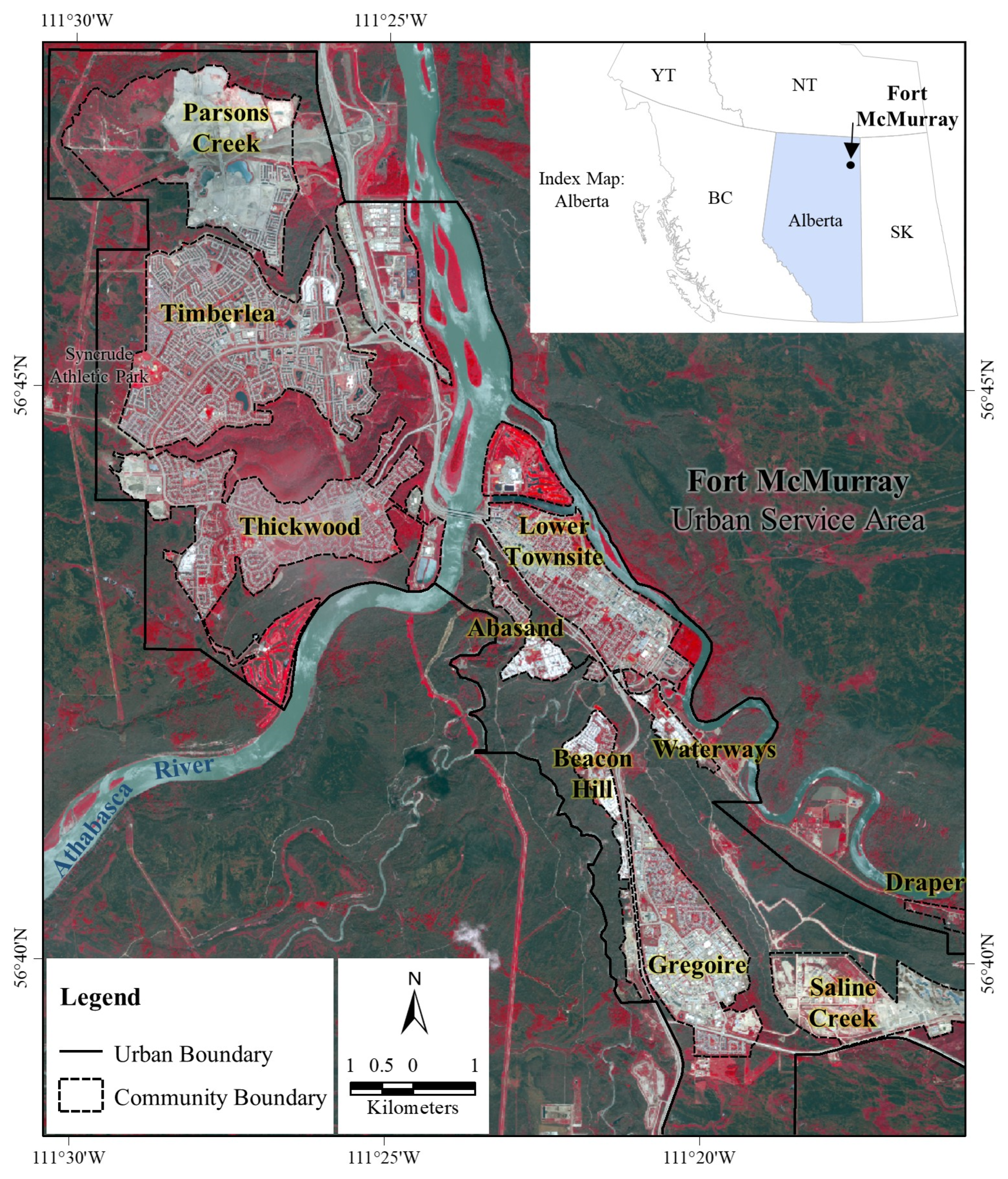
2.1. Study Area

Our study area is Fort McMurray, which is an urban service area in the RMWB situated in the northeastern part of Alberta, Canada (Figure 1). This area is approximately 450 km northeast of Edmonton, the capital of Alberta. The Athabasca River, the longest river in Alberta, passes through the area from the southwest towards the north. Fort McMurray city has been the center of the oil sands industry in the Greater Athabasca Region that dominates the local to the national economy, contributing to 30% of the total regional labour force [33]. The population in the city has increased significantly from approximately 1186 to 66,573 during 1961–2016 [34,35]. Such a population increase may happen due to the rapidly developing oil sands resources in the region, which is the third-largest oil deposit in the world, with a spatial extent of approximately 140,000 km2 [36].
A borderline subarctic climate characterizes the region that causes severe winter and mild-warm dry summer. In Fort McMurray, the daily average temperature in January (a winter month) and July (a summer month) was −17.4 and +17.1 °C, respectively, for the period 1981–2010 [37]. During the period, the area received an annual average precipitation of 418.6 mm [37]. The area is situated in the ‘Northern Alberta Lowlands’ physiography [38] with an average elevation of 369 m above mean sea level [39]. Ecologically, the area is in the ‘Central Mixedwood’ natural subregion of Alberta [38] and bordered by thick boreal forest consisting of bogs, oil sands and dense coniferous forest [40]. This subregion often time experiences wildland fires due to dry summer and the abrupt presence of the hefty boreal forest. For example, during 1961–2014, this subregion suffered from 18,424 wildland fires (~51% lightning-caused and ~49% human-caused), which was about 34.37% of the total wildland fire incidents in Alberta [41].

2.2. Methods

We adopted a method consisting of four main steps. First, we obtained scientific evidence and generated models highlighting wildland fire-induced risk zonation and mapping [1] from Earth Observation for Environment Laboratory (EOEL) at the University of Calgary (UofC). Second, we identified the stakeholders and rightsholders in the RMWB area, prepared the questionnaire, decided on the survey format, and received ethical approval from the Research Ethics Board (REB) of UofC. During the process, we selected both stakeholders and rightsholders according to the recommended protocols suggested by OCAP (Ownership, Control, Access, and Possession) [42] and TCPS (Tri-Council Policy Statement) [43]. Note that the principles of OCAP uphold that the First Nations have control on data collection processes, and they own and control the use of this information; and TCPS promote the ethical conduct for research involving humans in the fields of health, natural sciences and engineering, and social sciences and humanities. Third, we directed an online questionnaire survey. Finally, we performed data analysis and sent it to the participants for their further feedbacks.

2.2.1. Collection of Scientific Data and Models

We used the wildland fire-induced risk map for the Fort McMurray communities, the primary basis of this study, that was prepared after the HRF event (the fire entered from the southwest on 1 May 2016) primarily using a WorldView-2 satellite image acquired on 6 June 2016 [1]. Additionally, we collected remote sensing-based forecasting models to understand wildland fire danger conditions in the area, which were primarily based on the meteorological and biophysical variables of vegetation, such as land surface temperature, precipitable water, normalized difference vegetation index, normalized difference water index; and historical ignition cause-specific static fire danger (SFD) maps [44,45,46]. We considered all the recommendations of these models for preparing the survey questionnaire in this study. It would be worth noting that we obtained the comprehensive dataset from the integrated analysis of satellite images and GIS (geographic information systems) to make the generated maps available for potential use in this research.

2.2.2. Preparation for the Survey

In order to make a plan for engaging the communities in this research, we prepared a list of 75 email addresses of potential participants involved in natural disaster management activities based on literature review (e.g., [47,48]) and public perceptions widely available in Alberta. These invited participants were from various organizations including Fire and Law Enforcement Department, Chamber of Commerce, Canadian Red Cross, Insurance Bureau of Canada, Fort McMurray Tourism, Elected Political Leaders, Non-Government Organizations (NGO), Voluntary Organizations, First Nations, and Métis Organizations. In the case of getting responses, we assumed to have a response rate of about 20% like other Canadian studies [49].
We prepared a questionnaire for the survey comprising four sections. The first section included respondents’ agreement and contact details (i.e., name, email address, and affiliated organization). The second section highlighted the technical questions related to wildland-urban interface (WUI) buffer, wildland fire-induced risk zonation mapping, and importance of social and physical infrastructures (e.g., religious establishments, schools, athletic parks/arenas, commercial entities, shopping malls, ring roads, etc.) and few other associated information in graphical formats. In section three of the questionnaire, we asked for information related to the involvement of the respondent’s organization during and after the 2016 HRF event and whether the organization received any training programs after the event to enhance the organizational capacity in managing wildland fire-induced risks. The final section consisted of short questions with options to share the initial summary of the anonymous survey data and further potentials of scientific publications and thanking notes for completing the survey.
Initially, we had a plan to organize a day-long workshop at Fort McMurray inviting the targeted stakeholders and rightsholders for focus group discussion and completing the structured questionnaire survey. However, due to the ongoing COVID-19 pandemic, we opted to use an online platform for the questionnaire survey using the Qualtrics system licensed and administered by the UofC’s web portal.
Once we finalized the lists of participants (i.e., stakeholders and rightsholders), the questionnaire, and the survey data collection method for this study, we applied for the ethical approvals from UofC’s Conjoint Faculties Research Ethics Board (CFREB). Here, we followed two different protocols for receiving ethical approvals to engage the stakeholders and rightsholders (i.e., First Nations and Métis Organizations) in the survey. For the approval related to the stakeholders, we prepared and provided a list of stakeholders (as outlined in Section 3.2.1) along with a draft cover letter of communication as an attachment. However, in the case of rightsholders’ engagement, we followed the OCAP and TCPS guidelines. As per the instructions, we provided a list of the identified rightsholders in the study area with their contact details. Simultaneously, we communicated with the First Nations and Métis Organizations with trying to set up the network for collaboration in this research project. Note that a research agreement would be required before recruiting a participant from the rightsholder groups along with the ethical approvals [39].

2.2.3. Directed Online Questionnaire Survey

Once we received the ethical approvals, we set up our prepared questionnaire into the Qualtrics system to record the participants’ responses online. All the questionnaires were designed with the options of agree, somewhat agree, disagree, and unknown. There was an additional option with each asked question to provide comments. After finalizing the online setup, we sent invitations via emails to the listed stakeholders and rightsholders (if agreed) to participate in the online survey. We also attached two documents with the email, including (i) CFREB approved certification of institutional ethics review; and (ii) CFREB provided consent form. Finally, we sent the online survey link to the stakeholder/rightsholder in another email with thanks, who replied to our previous email by providing consent to participate in the survey.

2.2.4. Data Analysis and Feedback Mechanisms

The respondents completed a set of questions distributed online. Once we captured the responses, we compiled and analyzed them to understand several themes highly connected with future risk mitigation and management strategies of wildland fires in the RMWB. The responses were quantitatively analyzed based on the provided options (i.e., agree, somewhat agree, disagree, and unknown) for each question. In the case of no response, it was also included in the analysis to understand the percentage of participants who did not answer a question. Additional comments provided by the participants were also synthesized and summarized. Once we analyzed the data of the responses and synthesized the additional comments obtained through the questionnaire survey, we sent the summarized outcomes to the respondents who only decided to see the synthesized anonymous data before any formal publication. Finally, we started to connect with the generated models, participants’ views, and professional thoughts to complement the policies relevant to wildland fire-induced risk mitigation measures in the study area.

3. Results

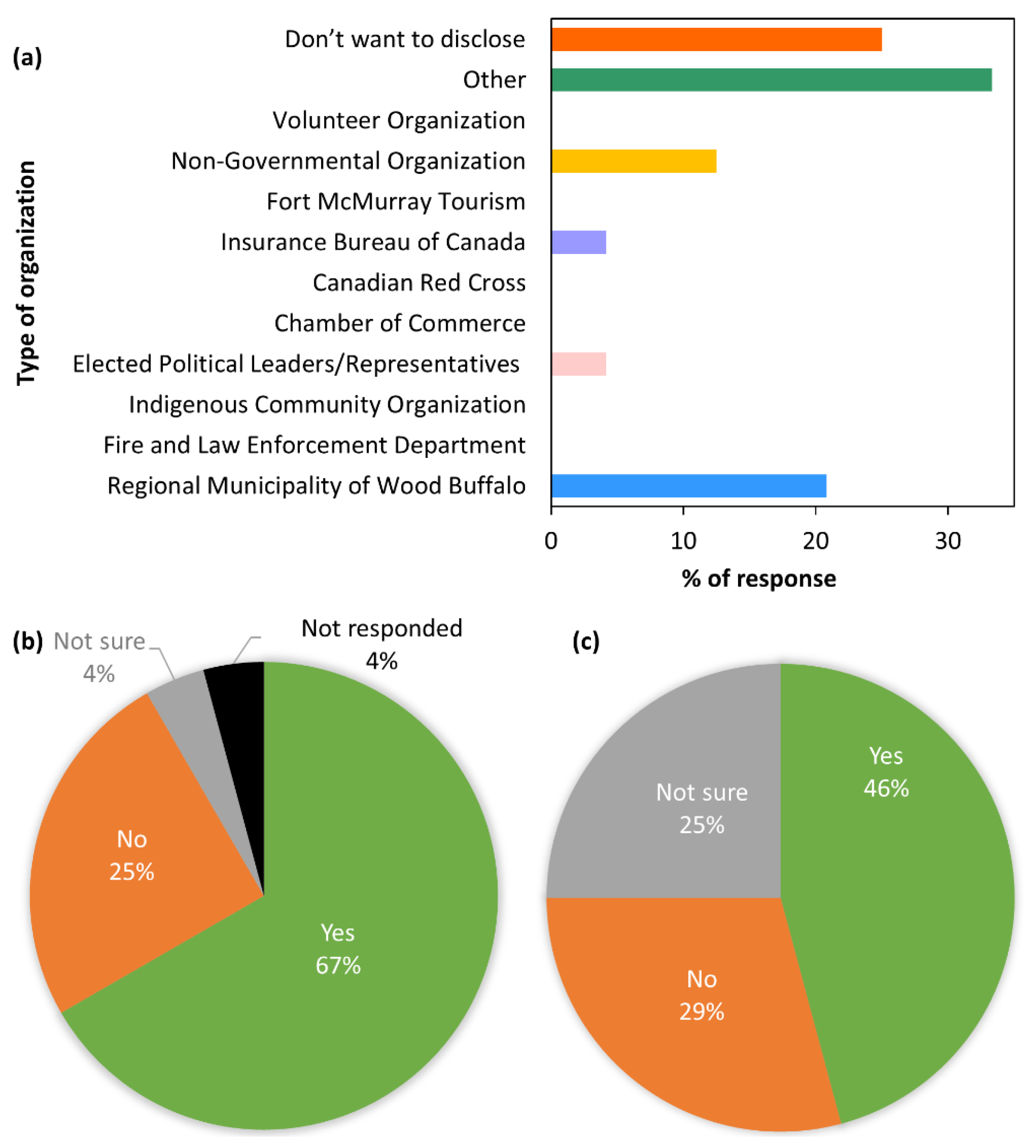
3.1. Participants’ Responses about Their Organizations and Its Involvement

This survey had been open for the period June 2020 to April 2021. Upon concluding the survey, we found that 24 participants responded to our invitation, providing a 32% response rate. Figure 2 shows the type of participants’ affiliated organizationsand quantifies whether their organizations have collaborated/cooperated/coordinated with others during the 2016 HRF event and received any further training/capacity building programs after the disaster.
Upon analysing the responses to the question entitled “Have your organization collaborate/cooperate/coordinate with others during and after the 2016 Horse River Fire?”, we found that at least 67% of the participants’ organizations mentioned such activities (Figure 2b). In these cases, they also briefly explained the extent of their organizational efforts, and these activities could be summarized as follows:
  • working with Provincial and Federal Governments, including Alberta Emergency Management Agency, Alberta Forestry, Regional Operations Centre, etc.;
  • cooperating with the Local Government;
  • providing support to the fire victims;
  • involving in the evacuation responses;
  • monitoring of the regional air quality; and
  • assessing the environmental impacts of fire on canopy structure, among others.
Additionally, in response to the question asked “Have your organization received any further training/capacity building programs after the 2016 Horse River Fire in wildland fire-induced risk management?”, we found that at least 46% of the participant’s organization had attended such programs (see Figure 2c). When the responses were ‘yes’, the participants also briefly explained the extent of further training and/or capacity building programs in their organization that were received after the 2016 HRF event. Those included: (i) development of business continuity plan, which came into effect during the wildfire and again COVID-19 lockdown making sure that these were prepared to respond in case of an emergency; (ii) adaptation of a nationally recognized program like FireSmart, including rehabilitation of fire affected cities in forests and support for personal property redevelopment; (iii) training on Incident Command System, i.e., a standardized management system to organize and manage a scalable response to any emergency incidents [50]; and (iv) performing Table Top simulations [51], among others.

3.2. Participants’ Perception Related to Wildland Fire-Induced Risks and Its Mitigation

Here, we summarized the participants’ perception about wildland fire-induced risks and their mitigation, where the questions were formulated based on an earlier published article, i.e., Ahmed et al. 2018 [1], related to the 2016 HRF incident in Fort McMurray. Note that the background image used in Figure 3, Figure 4 and Figure 5 was acquired by the WorldView-2 satellite on 6 June 2016.

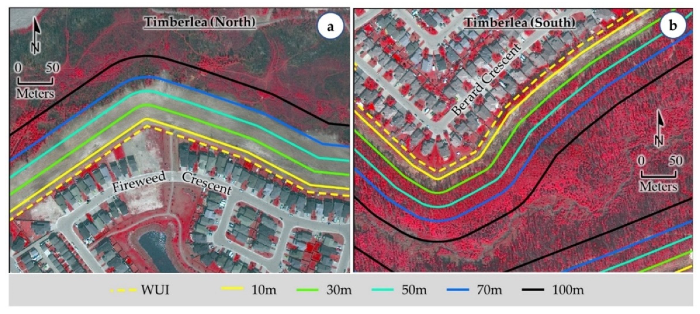
3.2.1. Views about the Characteristics of 30 m Buffer Zone

In response to the question entitled “Ahmed et al. 2018 had observed the existence of forest (fuel for the fire) within the 10–30 m (i.e., about 30–90 feet) from the WUI as shown in the figure below (referred to as Figure 3 in this document) (i.e., blackish tone of the burned forest) near the Abasand and Beacon Hill communities. Thus, we may infer that the zone of 30 m buffer from the WUI should have very little to no existence of forest/vegetation to reduce the propagation of wildland fire into the communities. Do you agree with this statement? Please briefly explain your opinion.”, we found that at least 63% of the participants agreed with the statement (see Table 1). Once the participants agreed, they also explained the importance of having no vegetation in the 30 m buffer zone. In this case, they emphasised the fact that it would reduce wildfire-associated risks by clearing the fuel (i.e., vegetation), which would be critical to initiate wildfires and their potential spreading towards the built-up area. Some of the noteworthy quotes were:
  • “A 30 m buffer is consistent with other environmental offsets between urban development and natural settings.”;
  • “That (30 m buffer) would reduce the fuel, which is an important part in starting and developing wildfires. You can build a path with certain width, and also you can use fire resistant materials in structuring the paths.”;
  • “It was determined that 30 m is the minimum distance to achieve in order to achieve any benefit reducing the thermal transfer of heat.”
Despite agreeing with the suggestion, several participants pointed out two issues: (i) the 2016 Horse River Fire jumped over the Athabasca River, which was having a width greater than 30 m; and (ii) some landowners or developers would prefer to keep green vegetation close to their properties for beautification upon not following the FireSmart guidelines. Additionally, we also observed some disagreements, quoted as follows:
  • “I think this is small enough distance. 200 m I think can be considered safe considering the forest height is below 10 m at the edge of the forest.”;
  • “No, in the case of the 2016 fire, it was creating its own systems. It sent a heat wave first and that is was caused some of the damage in Beacon hill especially.”

3.2.2. Views about the Characteristics of 70 m Buffer Zone

In response to the question, “In Panel (a) of the following figure (referred as Figure 4 in this document), Ahmed et al. assumed that relevant authorities removed forest/vegetation between 30 m and 70 m buffers from the WUI to protect the structures in the nearby communities, i.e., Timberlea. Furthermore, panel (b) of the figure (i.e., Figure 4) shows the existence of dense vegetation (shown in reddish color) within 10 to 70 m from the WUI after the 2016 HRF event; and identifies as forest fire-induced vulnerable areas. In order to reduce the wildland fire-induced risk, we may emphasize that a vegetation zone of up to 70 m from the WUI would enhance the safety measures to reduce the wildland fire-induced risk. Do you agree with this statement? Please briefly explain your opinion.”, we realized that at least 68% of participants agreed with this statement (see Table 2). They also provided additional comments comprising of:
  • “I agree based on the logical perspective. 30m is safer than 10 m, 70 m is safer than 30 m. The distance between combustible material directly impacts the propagation or spread of fire.”;
  • “This 70 m buffer zone would be optimistic target for reducing the fire risk depending upon the weather condition.”;
  • “These buffer zones can be useful recreation/greenspace for the surrounding communities.”;
  • “The extended vegetation zone will enhance more safety against forest fire. The extended zone will ensure the forest fire blow of burning fuel burn completeness (the dry leaves particles and dry wood husk are the fuel of forest fire). This 30 to 70 m is enough space to control the fire by facilitating the fire itself to be as control burned, it will not catch the building/other object.”
Note that participants also mentioned the importance of such 70 m buffer with some caution, e.g., the loss of wildlife habitat and cost of land acquisition and maintenance, in particular. In case of disagreements, one of the participants mentioned, “there must be a happy medium, because vegetation helps lowering the water table as most of the RMWB is built on marshlands, and 2016 Horse River Fire jumped over the Athabasca River which is at least 1000 m wide.”. Additionally, another participant noted, “I would believe that we should create and design a mosaic of different landscapes with different vegetation cover in order to reduce the expansion of wildfires.”, which might be important for reducing the fuel loading for fire severity reduction purposes.

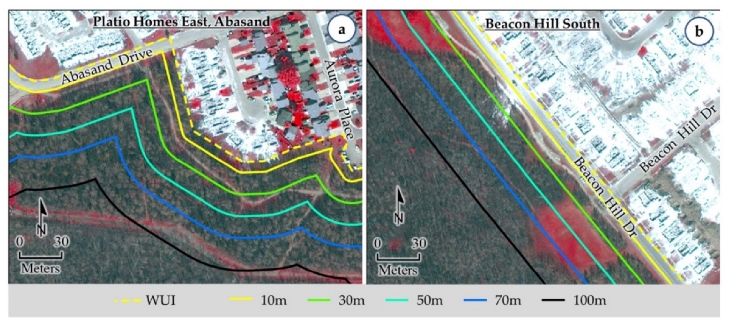
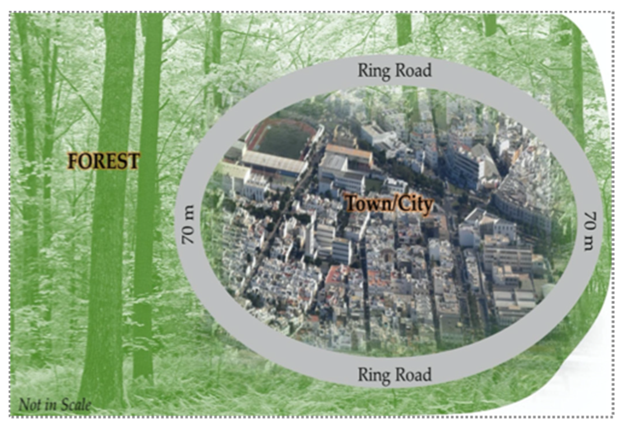
3.2.3. Views about the Construction of a Ring Road with a Width of 70 m

In response to the question entitled, “According to Ahmed et al. 2018, we recommend that the construction of a ring road with a width of about 70 m around a community as shown in the following figure (referred to as Figure 6 in this document) may potentially reduce wildland fire-induced risks. Do you agree with this statement? Please briefly explain your thought.”, we observed that at least 72% of the participants agreed (see Table 3). In further explanation, they mentioned that such a ring road would provide an extra buffer zone of protection from wildland fires, add scenic beauty to the community, offer alternate exit route of evacuation during an emergency (e.g., highway 63 was the only highway to communicate with Edmonton and Timberlea during the recent flood), and ensure better accessibility for emergency service crews to combat fires, etc. In this context, we opted to quote some of the detailed comments, including:
  • “It (ring road with a width of about 70 m) provides separation of combustible material. The significance of a ring road provides a defensible space for emergency response crews. It provides opportunity for municipally supplied water supply to assist in mitigation efforts. Analysis of the 2016 Horse River Wildfire, the concept of a road around the perimeter of a neighbourhood proved to be beneficial in minimizing damage to structures along Signal Road in the Thickwood area of Fort McMurray.”;
  • “Possible ring road construction with the mentioned approximately 70 m gap will also a scientific safety measure to prevent forest fire to the community establishments, buildings, business facilities with residence. This ring type road with continuous gap zone will provide buffer safety space which facilitates the blowing wind carrying forest fire fuel (the leaves, dust of plant leaves, wood husk, dead tree husks) to burnt out itself within this space, so it will lose the fire catching ability. So, no fire expanded. With Minor modification to older communities like Thickwood, Timberlea, and Eagle ridge, it could be possible; and up front this concept could be in policy & plan for the new communities or on-going developments of existing new subdivisions like stone creek.”;
  • “Few communities already have right roads around and then children park facing forest. The walking trails are built around the communities facing forest. There is buffer zone between walking trails and communities. These are built after 2016 fire.”
Though, some of the participants appreciated the concept of having a ring road especially for newly designed communities; however, noted that these might not be realistic and economical for the existing urban centres. In some cases, the participants indicated this (ring road) might not reduce the fire risk but would provide an alternate exit route and prevent bottlenecking during an emergency. Finally, the participants with disagreements quoted as, “Not applicable practically. Trees are long in the range of 10~20 m, wind accelerated fire to approximately over 100 m” and “My opinion is roads shouldn’t be used a buffer as the road vehicles are also fire risk assets. Especially roads could be full with slow moving vehicles during rush hours”.

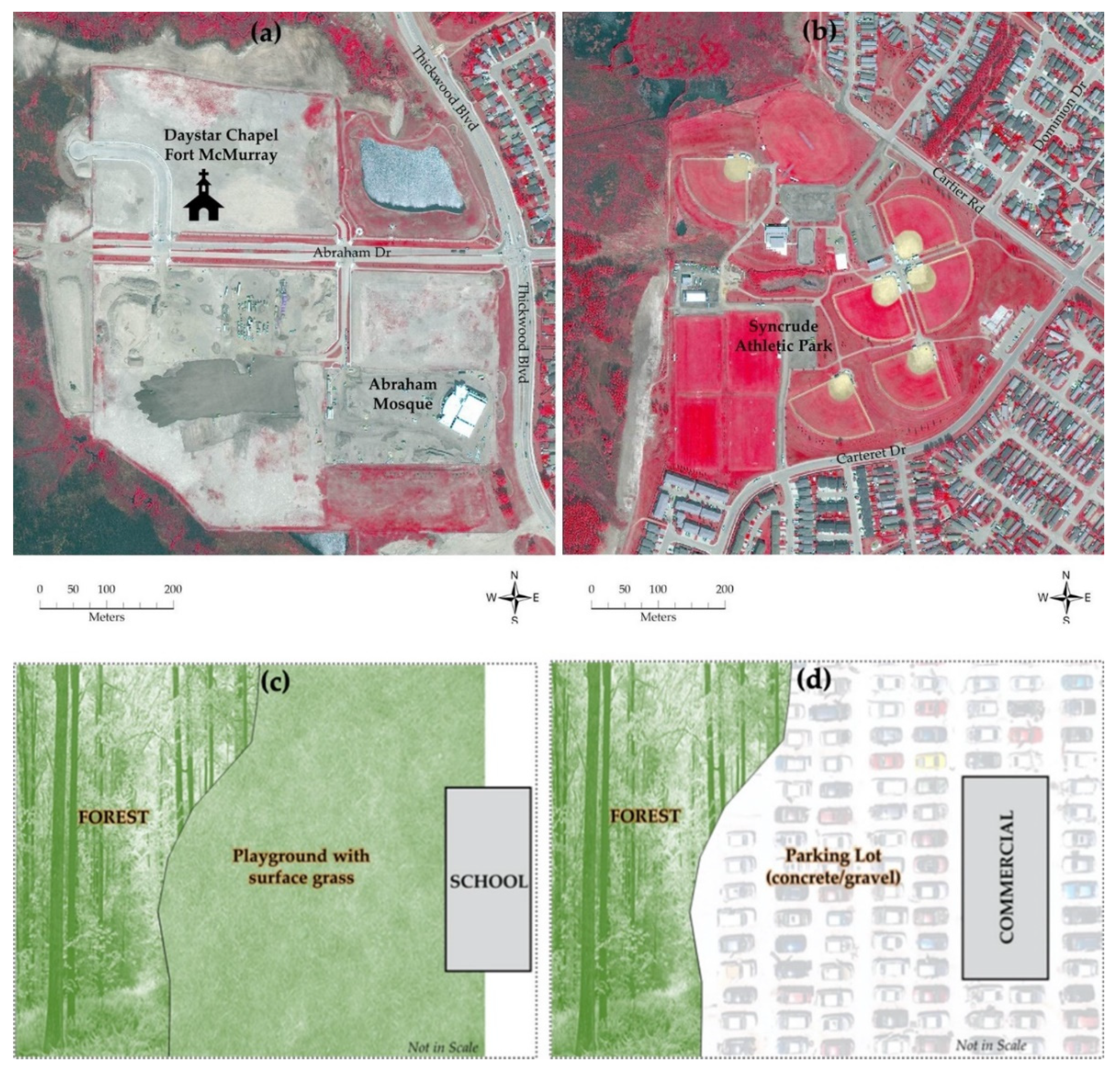
3.2.4. Views about the Placing of the Social Infrastructures

In response to the question entitled, “According to Ahmed et al. 2018, we recommend that major social infrastructures may be planned at the outskirts of the communities. This may follow a design guideline to establish the parking lots facing towards the forested areas to ensure buffer zones between wildland-urban interface (WUI) and forest. Do you think that such social infrastructures, including: (i) religious establishments; (ii) athletic parks/arenas; (iii) school buildings, or community centres; and (iv) commercial entities, e.g., Walmart, Superstores, etc.; may play a significant role in reducing forest fire-induced risks? Please briefly explain your perception under the respective figure/sketch (referred to as Figure 5 in this document).”, we noticed that at least 63 to 80% of the participants agreed (see Table 4). In general, the participants appreciated the concept of creating additional buffer zones using large parking lots between the forest and social infrastructures, which would act as safeguard/fire break for wildfire risk reduction. Moreover, in the case of wildfires that would burn forest-facing surface grass in the athletic parks and school playgrounds, the rate of burn would be significantly slow that potentially need more time to spread towards the communities. In fact, these would be substantiated in the following quotes:
  • “The parking may be at the closest area of the forest and keep the most vulnerable structure away from the source of fire.”, and “I agree based on the typical building construction of my experience religious establishments and the associated open space by the parking lot creating separation. The determining factor is the building construction of the building.” (applicable for all social infrastructures considered here);
  • “For religious establishments, the model in the sketch is a buffer zone concept at the forest facing direction. It should be included as a design guideline, which will safeguard against forest fire. There should be additional message for modification to mitigate risk for existing ones. If any revision in policy is already established, it should include (if not done yet) the modifying recommendations as a sub article where possible the buffer zone and forest facing area to be created as additional safeguard. The threat of fire still exists.”;
  • “Athletic Park arena also follows the buffer zone to the forest facing direction as well as the parking space could be included as a buffer space.”;
  • “School/community centre, where the represented buffer zone concept is adequate. In general risk assessment, this buffer zone is a safeguard. To establish or introduce the safeguard, design guidelines could incorporate the concept. For existing school facilities, a modifying recommendation with this model to mitigate whatever residual fire risk existed. In case of a new facility, my opinion is ‘maybe’ as a buffer zone. Similarly parking lots could be in between forest and the facility building as buffer space.”.
Despite agreements, participants also indicated several issues and quoted as:
  • “This can be placed outside the city or at the vicinity of the city but requires public transportation and many other infrastructures.” (for athletic parks/arenas);
  • “For fire prone areas, I agree to this statement but again everyone want the school to be in walking distance from home within the community as we need to consider bear/wildlife coming from forest too.”;
  • “Could be, however, in case of any fire, this could lead to shortage of essential supplies to the community”, “For fire prone areas, it is a good suggestion, but we all want this (mall/Walmart) still in the town, not relocated away from center. As of now Walmart is at the edge of the river with parking facing towards inside the town, not forest.”, and “Walmart, Superstore, Sobeys, Canadian Tyre, RONA, Bricks, all these business facilities are old establishments, there might be less room to re-plan & construction or may not be necessary for buffer zone.” (for commercial entities).
In case of the disagreements, participants noted the following: (i) “The arena itself might be a big hitter by blowing its own equipment.”, (ii) “Devastating loss to the community if structures are used as firebreaks and fringe infrastructure. Wouldn’t recommend.”, (iii) “No. As damaging the commercial entities will lead to a significance financial loss.”, and (iv) “Anthropogenic concerns for off-site releases and habitat disturbance of large commercial sites.”

3.2.5. Participants’ Own/Additional Views

In response to our open-ended question entitled, “If not pointed out in the scope of the earlier questions, what you additionally consider that may potentially reduce the forest fire-induced risks to the communities located in the heart of forested land in case of its sustainability, redesign and new developments of such localities.”, we observed that about 70% of the participants provided additional feedback that could be categorized into several themes. For example: (i) importance of multiple exit routes (alternate access road) in case of disaster/emergency evacuation; (ii) use of fire resistive/non-combustible construction materials; (iii) adoption of public education/outreach for FireSmart practices [52]; (iv) forest, WUI, and fire management that include forest thinning, increasing bylaw patrols for misuse of the WUI with off-highway vehicles, taking precautionary measures during hot seasons to proactively identify fire and nip them in the bud before spreading towards the community, posting more signs and creating awareness during the fire season; and (v) potential characteristics of buffer zones. In the case of the ‘buffer zones’ theme, the participants provided numerous ideas, where some of the noteworthy ones are as follows:
  • “Industry sites were largely unaffected by fire due to having large buffer zones around them.”;
  • “Provincial support (would be required) in allocating greater buffer zones around municipalities.”;
  • “Fort McMurray is a hilly area with landscape created in last ice age. So new communities can be extended to the end of top of a hill with cleared safe zone in the downhill. Even 100 m safe zone would have little with fire & wind on flat areas next to continuous forest.”;
  • “Build high rise apartment building (brick/steal) within smaller area and leave more space between community and wildland.”; and
  • “Use of other means like wetlands as buffer which may not require huge width.”
Though, one of the participants acknowledged the effectiveness of the buffer zones; however, suggested considering the use of fire resistive construction materials as well. According to this participant, the quote read as, “… distance in separation (i.e., buffer zones between buildings and forest) addresses thermal heat transfer, what it does not protect against the fire ember transfer that can travel up to a kilometre. The use of non-combustible building construction reduces ignition which reduces fire generation which reduces heat generation. Consider the use of natural vegetation species that are resistant to fire.” Another quote about future wildland fire risk management stated like, “managing future wildfire risk requires an interface between human decision processes and knowledge about climate trends related to fire, as well as humans’ abilities to anticipate wildfire potential and mitigation approaches are critical.”. Finally, it would be worthwhile to note that several complimentary comments were observed, such as, “Potential scopes are addressed already”, “Most of the key points are addressed here”, and “I am encouraged by your line of questioning and thought process.”.

4. Discussion

Among the organization types in this survey, there was no participation recorded for the categories of ‘Indigenous Community Organization’, ‘Fire and Law Enforcement Department’, ‘Chamber of Commerce’, ‘Canadian Red Cross’, ‘Fort McMurray Tourism’, and ‘Volunteer Organization’. Apart from the ‘Indigenous Community Organization’ types, it might be quite possible that the other non-recorded categories of organizations were included under the category called ‘Don’t want to disclose’. Furthermore, some of the participants from ‘Fire and Law Enforcement Department’ and ‘Elected Political Leaders/Representatives’ (i.e., from the Local Government) might opt to declare their affiliations with the ‘Regional Municipality of Wood Buffalo’, because they are an integral part of the Municipal Government’s business and operation. Additionally, in the case of the participants who declared their organizational type as ‘Other’, they were primarily affiliated with oil and gas, and environmental monitoring/assessment sectors according to their further clarifications. Note that we approached 74 professionals in different organizations, and received responses from the 24 participants, which was lower than we expected.
The majority of the respondents in this survey agreed (i.e., 63%) with our proposed concept of very little to no existence of forest/vegetation in the 30 m buffer zone from the WUI. This zone also aligned with the combined zones 1 and 2 (i.e., 10 m and next 20 m from WUI, respectively) in the FireSmart guidelines that recommended as the Interface Priority Zones [11]. This 30 m priority zone could significantly reduce the potential of wildland fire propagation into the communities and minimize the potential of getting ignition into the structures due to the radiant heat of thermal energy during a wildland fire. However, we did not consider the fuel types for the zone in this study. In addition, we proposed to extend this zone up to 70 m (an additional 40 m from the 30 m zone), which is not available in the FireSmart guidelines. We assumed this 70 m buffer zone without vegetation would be very much appropriate when we observed that relevant authorities removed vegetation up to 70 m as a safety measure during the 2016 HRF event to protect the structures in the Fort McMurray communities [1]. Therefore, we would like to recommend a new priority zone up to 70 m worth to include in the FireSmart guidelines to reduce the wildland fire-induced risk for the communities. The surface of this zone could be non-combustible materials, including bare soil, surface grass, gravel, ditch (water body), asphalt, etc. We suggest planning a part of this zone for the recreational purpose for the associated communities that incudes developing bike trails, walking/running trails, tennis courts, basketball courts, public sitting arrangements (i.e., putting chairs and tables), etc.; however, we would suggest not developing any picnic facilities because picnic fires might potentially be responsible for human-induced ignition source for wildland fires. Additionally, part of this zone could have linear water bodies with water recreation-related facilities. Interestingly, our suggested 70 m width ring road (including asphalt surface, median, slopes, and ditches) could also be a part of this proposed 70 m priority zone. Developing such a ring road around the communities was well accepted by the participants (i.e., 72%) to reduce wildland fire-induced risks. Here, we also found that having a ring road was a pressing issue for the Fort McMurray communities. Moreover, a ring road around the communities would be helpful for easy mobilization of the residents and facilitating the evacuation in any emergencies. Note that some of these development activities have already been started in the study area according to the comments received from the participants.
In addition, proper management of vegetation in the 70 m buffer priority zone would be worth protecting the communities from fire propagation or radiant heat during a wildland fire; however, it might not provide enough protection from the inevitable burning embers or firebrands. In fact, wind might carry thousands of burning embers or firebrands during wildland fires and showers down on the structures and homes that may cause starting of spot fires. These ambers (or firebrands) usually would travel a distance of 100 to 500 m [53]; sometimes more than five kilometers [54] to a maximum of nine kilometers [55]. Due to such travelling capacity of ambers, we believed that the 2016 HRF jumped over the Athabasca River with an approximate 400 m width according to our analysis from south to the north that created its own fire environment. Considering these wildland fire-induced risks for the communities, we would also suggest constructing the structures and homes with non-flammable, non-combustible and fire-resistant materials. For example, metal, tile, asphalt, ULC-rated treated shakes or other non-combustible material could be used for roofing material to resist starting spot fires from burning ambers [11]. In addition, constructing materials of the building exterior, including stucco, metal siding, brick, cement shingles, concrete block, poured concrete, rock, and tempered glass for window and door glazing might offer superior resistance from potential fires due to burning ambers [11].
In the concept of placing the social infrastructures at the outskirts of the communities, where associated parking lots are facing towards the forest, we received the least amount of agreement for the commercial entities (i.e., 63%). Here, most of the respondents did not agree to use the commercial entities and community structures as firebreaks, even in the fringe areas, because it would incur a significant financial loss. Therefore, we are suggesting not to displace any of the existing entities as firebreaks, but rather to integrate this concept in the cases of future commercial/community developments in the study area. In this case, the authorities should consider providing the required facilities like transits to ensure better accessibility to those commercials.

Limitations of the Study

Despite providing the most possible efforts for conducting a comprehensive study to collect the perceptions of mitigation strategies based on scientific evidence after the 2016 HRF, we identified the following limitations of this study:
  • The number of professional participants (i.e., 24 out of invited 74) may not be potentially reflecting the views of the entire professionals/population in the study area, although the received response rate was 32%, which is acceptable. A limited number of responses were received because the potential participants were impacted by the COVID-19 pandemic. It could be avoided by collecting the data through a workshop, which was our initial plan though. However, the study area was hard-hit by COVID-19 during the survey period, and the government imposed several tight restrictions that prevented us from organizing such a workshop.
  • We did not exclusively integrate the fuel (vegetation) loading factors in this survey that are involved in the priority zone of WUI in relation to the wildland fire-induced risks. In fact, we focused on the risks for a single location in the boreal forest region (with borderline subarctic climate) based on a single event (i.e., the HRF) because it is the costliest disaster in Canadian history. However, along with the weather condition (i.e., air temperature, wind speed and direction, and relative humidity), fuel types and their management in the buffer zone play an important role not only for the wildland fire behavior but also for the fire occurrences. Moreover, fuel types would be different in other climatic conditions in other regions compared to the subarctic boreal forest area of this study. Therefore, we understand the need for regular monitoring of fuel loading at certain intervals [1,56] and managing and landscaping the fire-resistant fuel types as green firebreaks in the buffers of the WUI according to the climate zone [57,58,59,60].

5. Concluding Remarks

In this study, we demonstrated the use of the participatory approach in synthesizing wildland fire-induced risk mitigation strategies. Here, we sought views from the participants in the study area, when they were affected by the 2016 HRF. We received reasonably high agreements from the survey participants (i.e., between 63 to 80%) regarding vegetation management in WUI (30 m buffer zone), an extension of the characteristics of WUI from 30 m to 70 m, construction of a 70 m width ring road around the communities and placing the parking lots between forest and social infrastructures in the fringe areas of the communities. Despite the high agreements, we also received few additional views, such as using fire-resistant materials in constructing structures and homes; and utilizing the vegetation-free buffer zone as recreational spaces. These approaches of mitigating wildland fire-induced risks in the communities could be applicable to other urban and communities in the Boreal forested region of Canada. However, we suggest further investigation before adopting these proposed mitigations in other types of wildlands (in terms of landscape, topography, and fuel type) elsewhere in Canada and other places in the world. We also recommend further research to evaluate the landscaping characteristics of the 70 m buffer at WUI for making a wildland fires resilience community.

Author Contributions

All the authors, Q.K.H., K.R.R., M.R.A. and S.M.H. contributed to the design and implementation of the research and writing the manuscript. All authors have read and agreed to the published version of the manuscript.

Funding

This study was funded by Alberta Land Institute through a grant to Q.K.H. The funding agency played no role in study design; in the collection, analysis, and interpretation of data; in writing of the manuscript; and in the decision to submit the article for publication.

Institutional Review Board Statement

The study was conducted according to the guidelines of the Tri-Council Policy Statement: Ethical Conduct for Research Involving Humans (TCPS), and approved by the Conjoint Faculties Research Ethics Board at the University of Calgary (Ethics ID: REB20-0320 approved on 12 May 2020).

Informed Consent Statement

Informed consent was obtained from all subjects involved in the study.

Data Availability Statement

Not applicable.

Acknowledgments

The authors would like to acknowledge the participants who have provided valuable inputs to the study.

Conflicts of Interest

The authors declare no conflict of interest.

References

  1. Ahmed, M.R.; Rahaman, K.R.; Hassan, Q.K. Remote sensing of wildland fire-induced risk assessment at the community level. Sensors 2018, 18, 1570. [Google Scholar] [CrossRef] [PubMed] [Green Version]
  2. NRCan (Natural Resources Canada) Wildland Fire Evacuations. Available online: http://www.nrcan.gc.ca/forests/climate-change/forest-change/17787 (accessed on 13 June 2018).
  3. McIntyre, J. Moving forward: The Economic Impact of Rebuilding the Wood Buffalo Region’s Economy; The Conference Board of Canada: Ottawa, ON, Canada, 2017. [Google Scholar]
  4. Landis, M.S.; Edgerton, E.S.; White, E.M.; Wentworth, G.R.; Sullivan, A.P.; Dillner, A.M. The impact of the 2016 Fort McMurray Horse River Wildfire on ambient air pollution levels in the Athabasca Oil Sands Region, Alberta, Canada. Sci. Total Environ. 2018, 618, 1665–1676. [Google Scholar] [CrossRef] [PubMed]
  5. McGee, T.K. Preparedness and Experiences of Evacuees from the 2016 Fort McMurray Horse River Wildfir. Fire 2019, 2, 13. [Google Scholar] [CrossRef] [Green Version]
  6. Statistics Canada. Census Profile, 2016 Census: Fort McMurray [Population Centre]. Available online: https://www12.statcan.gc.ca/census-recensement/2016/dp-pd/prof/details/page.cfm?Lang=E&Geo1=POPC&Code1=0292&Geo2=PR&Code2=47&Data=Count&SearchText=FortMcMurray&SearchType=Begins&SearchPR=01&B1=All&wbdisable=true (accessed on 19 July 2021).
  7. Okkola, S.; Brunelle, C. Has the oil boom generated new problems of housing affordability in resource-driven agglomerations in Canada? A case study of St. John’s, Saskatoon, Calgary, Edmonton, and Fort McMurray, 1991–2011. Urban Geogr. 2018, 39, 299–327. [Google Scholar] [CrossRef] [Green Version]
  8. Dorow, S.; O’Shaughnessy, S. Canadian Journal of Sociology. Can. J. Sociol. 2015, 34, 121–140. [Google Scholar] [CrossRef]
  9. FireSmart Canada. What Is the Wildland-Urban Interface? Available online: https://www.firesmartcanada.ca/what-is-firesmart/understanding-firesmart/what-is-the-wui/ (accessed on 20 July 2021).
  10. Government of Alberta. FireSmart: Guidebook for Community Protection. A Guidebook for Wildland/Urban Interface Communities; Alberta Environment and Sustainable Resource Development: Edmonton, AB, Canada, 2013; ISBN 978-1-4601-0780-5.
  11. Partners in Protection. FireSmart: Protecting Your Community from Wildfire, 2nd ed.; Vicars, M., Ed.; Natural Resources Canada, Canadian Forest Service, Northern Forestry Centre: Edmonton, AB, Canada, 2003; ISBN 0-662-34064-7.
  12. U.S. Fire Administration National Wildfire Coordinating Group. Wildland Urban Interface (WUI). Available online: https://www.usfa.fema.gov/wui/ (accessed on 20 July 2021).
  13. Radeloff, V.C.; Hammer, R.B.; Stewart, S.I.; Fried, J.S.; Holcomb, S.S.; McKeefry, J.F. The wildland-urban interface in the United States. Ecol. Appl. 2005, 15, 799–805. [Google Scholar] [CrossRef] [Green Version]
  14. UNISDR. United Nations Office for Disaster Risk Reduction. In Words into Action Guidelines: National Disaster Risk Assessment (Governance System, Methodologies, and Use of Results): 6. Wildfire Hazard and Risk Assessment; UNISDR: Geneva, Switzerland, 2017. [Google Scholar]
  15. Haynes, K.; Handmer, J.; McAneney, J.; Tibbits, A.; Coates, L. Australian bushfire fatalities 1900–2008: Exploring trends in relation to the “Prepare, stay and defend or leave early” policy. Environ. Sci. Policy 2010, 13, 185–194. [Google Scholar] [CrossRef]
  16. Mell, W.E.; Manzello, S.L.; Maranghides, A.; Butry, D.; Rehm, R.G. The wildland—urban interface fire problem—current approaches and research needs. Int. J. Wildl. Fire 2010, 19, 238–251. [Google Scholar] [CrossRef]
  17. United States Department of Agriculture. Forest Service. Wildfire Risk to Communities. Available online: https://wildfirerisk.org/reduce-risk/home-ignition-zone/ (accessed on 21 July 2021).
  18. O’Neil, S.; Handmer, J. Responding to bushfire risk: The need for transformative adaptation. Environ. Res. Lett. 2012, 7, 014018. [Google Scholar] [CrossRef]
  19. Bento-Gonçalves, A.; Vieira, A. Wildfires in the wildland-urban interface: Key concepts and evaluation methodologies. Sci. Total Environ. 2020, 707, 135592. [Google Scholar] [CrossRef] [PubMed]
  20. UNDDR. United Nations Office for Disaster Risk Reduction. Wildfire Prevention in Australia; Emergency Management Australia in Conjunction with the Australasian Fire Authorities Council and Country Fire Authority: Victoria, Australia, 2000.
  21. National Fire Protection Association. Preparing Homes for Wildfire. Available online: https://www.nfpa.org/Public-Education/Fire-causes-and-risks/Wildfire/Preparing-homes-for-wildfire (accessed on 21 July 2021).
  22. FireSmart Canada. Seven FireSmart Disciplines. Available online: https://www.firesmartcanada.ca/what-is-firesmart/understanding-firesmart/seven-firesmart-disciplines/ (accessed on 20 July 2021).
  23. FiresSmart Canada. Home Ignition Zone. Available online: https://www.firesmartcanada.ca/what-is-firesmart/understanding-firesmart/home-ignition-zone/ (accessed on 21 July 2021).
  24. Hilton, J.E.; Leonard, J.E.; Blanchi, R.; Newnham, G.J.; Opie, K.; Power, A.; Rucinski, C.; Swedosh, W. Radiant heat flux modelling for wildfires. Math. Comput. Simul. 2020, 175, 62–80. [Google Scholar] [CrossRef]
  25. FireSmart Canada. Home Iginition Zone Poster. Available online: https://www.firesmartcanada.ca/wp-content/uploads/2019/10/FS_Home-Ignition-Zone-Poster.pdf (accessed on 22 July 2021).
  26. Graveland, B. Schools, ring roads and parking lots can help prevent spread of wildfires: Study. Natl. Post 2018.
  27. Jakes, P.J.; Sturtevant, V. Trial by fire: Community Wildfire Protection Plans put to the test. Int. J. Wildl. Fire 2013, 22, 1134–1143. [Google Scholar] [CrossRef]
  28. Hanes, C.C.; Wang, X.; Jain, P.; Parisien, M.A.; Little, J.M.; Flannigan, M.D. Fire-regime changes in canada over the last half century. Can. J. For. Res. 2019, 49, 256–269. [Google Scholar] [CrossRef]
  29. Tymstra, C.; Stocks, B.J.; Cai, X.; Flannigan, M.D. Wildfire management in Canada: Review, challenges and opportunities. Prog. Disaster Sci. 2019, 5, 100045. [Google Scholar] [CrossRef]
  30. Stocks, B.J.; Martell, D.L. Forest fire management expenditures in Canada: 1970–2013. For. Chron. 2016, 92, 298–306. [Google Scholar] [CrossRef] [Green Version]
  31. Labossière, L.M.M.; McGee, T.K. Innovative wildfire mitigation by municipal governments: Two case studies in Western Canada. Int. J. Disaster Risk Reduct. 2017, 22, 204–210. [Google Scholar] [CrossRef]
  32. McGee, T.K. Public engagement in neighbourhood level wildfire mitigation and preparedness: Case studies from Canada, the US and Australia. J. Environ. Manag. 2011, 92, 2524–2532. [Google Scholar] [CrossRef]
  33. Regional Municipality of Wood Buffalo. Envision Wood Buffalo towards 250k: Fort McMurray—Where We Are Today; RMWB: Fort McMurray, AB, Canada, 2008.
  34. Rahaman, K.R.; Hassan, Q.K.; Chowdhury, E.H. Quantification of Local Warming Trend: A Remote Sensing-Based Approach. PLoS ONE 2017, 12, 1–18. [Google Scholar] [CrossRef]
  35. Statistics Canada. Census Profile, 2016 Census: Fort McMurray. Available online: http://www12.statcan.gc.ca/census-recensement/2016/dp-pd/prof/details/page.cfm?Lang=E&Geo1=POPC&Code1=0292&Geo2=PR&Code2=47&Data=Count&SearchText=FortMcMurray&SearchType=Begins&SearchPR=01&B1=All&wbdisable=true (accessed on 21 November 2017).
  36. Papineau, J.W.; Deacon, L. Fort McMurray and the Canadian Oil Sands: Local Coverage of National Importance. Environ. Commun. 2017, 11, 593–608. [Google Scholar] [CrossRef]
  37. Environment Canada. Canadian Climate Normals 1981–2010 Station Data. Available online: http://climate.weather.gc.ca/climate_normals/results_1981_2010_e.html?stnID=367&autofwd=1 (accessed on 22 November 2017).
  38. Natural Regions Committee. Natural Regions and Subregions of Alberta; Downing, D.J., Pettapiece, W.W., Eds.; Government of Alberta: Edmonton, AB, Canada, 2006.
  39. Girardin, M.P.; Wotton, B.M. Summer moisture and wildfire risks across Canada. J. Appl. Meteorol. Climatol. 2009, 48, 517–533. [Google Scholar] [CrossRef]
  40. Stirling, M. Fort McMurray Wildfire 2016: Conflating Human-Caused Wildfires with Human-Caused Global Warming. Soc. Sci. Res. Netw. 2017. [Google Scholar] [CrossRef]
  41. Alberta Agriculture and Forestry. Alberta Wildfire: Historical Wildfire Database. Available online: http://wildfire.alberta.ca/resources/historical-data/historical-wildfire-database.aspx (accessed on 22 November 2017).
  42. FNIGC (First Nations Information Governance Centre). The First Nations Principles of OCAP. Available online: https://fnigc.ca/ocap-training/ (accessed on 8 May 2021).
  43. Canadian Institutes of Health Research, Natural Sciences and Engineering Research Council of Canada, Social Sciences and Humanities Research Council. Tri-Council Policy Statement: Ethical Conduct for Research Involving Humans—TCPS2 2018; Government of Canada: Ottawa, ON, Canada, 2018; ISBN 978-0-660-29942-6.
  44. Abdollahi, M.; Islam, T.; Gupta, A.; Hassan, Q. An Advanced Forest Fire Danger Forecasting System: Integration of Remote Sensing and Historical Sources of Ignition Data. Remote Sens. 2018, 10, 923. [Google Scholar] [CrossRef] [Green Version]
  45. Ahmed, M.R.; Hassan, Q.K.; Abdollahi, M.; Gupta, A. Processing of near real time land surface temperature and its application in forecasting forest fire danger conditions. Sensors 2020, 20, 984. [Google Scholar] [CrossRef] [Green Version]
  46. Ahmed, M.R.; Hassan, Q.K.; Abdollahi, M.; Gupta, A. Introducing a New Remote Sensing-Based Model for Forecasting Forest Fire Danger Conditions at a Four-Day Scale. Remote Sens. 2019, 11, 2101. [Google Scholar] [CrossRef] [Green Version]
  47. KPMG. Regional Municipality of Wood Buffalo Lessons Learned and Recommendations from the 2016 Horse River Wildfire; KPMG LLP: Zurich, Switzerland, 2017. [Google Scholar]
  48. Clark, T.D. Rebuilding Resilient Indigenous Communities in the RMWB: Executive Summary; The Athabasca Tribal Council, the Athabasca River Métis, and the Nistawoyou Association Friendship Centre: Cochrane, AB, Canada, 2018.
  49. Abba-Aji, A.; Li, D.; Hrabok, M.; Shalaby, R.; Gusnowski, A.; Vuong, W.; Surood, S.; Nkire, N.; Li, X.M.; Greenshaw, A.J.; et al. COVID-19 pandemic and mental health: Prevalence and correlates of new-onset obsessive-compulsive symptoms in a Canadian province. Int. J. Environ. Res. Public Health 2020, 17, 6986. [Google Scholar] [CrossRef] [PubMed]
  50. GoA (Government of Alberta). Online Courses—Incident Command System. Available online: https://www.alberta.ca/online-courses-incident-command-system.aspx (accessed on 22 April 2021).
  51. AEMA (Alberta Emergency Management Agency). Exercise Design 100. Available online: https://open.alberta.ca/dataset/07935297-2c3d-4773-9028-bbaf33fe98cf/resource/7361f1a0-bc1c-4ee3-9f7c-e8cd7860b122/download/ma-exercise-design-100-course-manual.pdf (accessed on 22 April 2021).
  52. GoA (Government of Alberta). FireSmart. Available online: https://wildfire.alberta.ca/firesmart/default.aspx (accessed on 24 April 2021).
  53. Westhaver, A. Why Some Homes Survived: Learning from the Fort McMurray Wildland/Urban Interface Fire Disaster; Institute for Catastrophic Loss Reduction: Toronto, ON, Canada, 2017. [Google Scholar]
  54. Beverly, J.L.; Bothwell, P. Wildfire evacuations in Canada 1980–2007. Nat. Hazards 2011, 59, 571–596. [Google Scholar] [CrossRef]
  55. Maranghides, A.; Mell, W. A Case Study of a Community Affected by the Witch and Guejito Fires; Technical Note 1635; National Institute of Standardsand Technology: Gaithersburg, MD, USA, 2009. [Google Scholar]
  56. Poulos, H.M.; Reemts, C.M.; Wogan, K.A.; Karges, J.P.; Gatewood, R.G. Multiple wildfires with minimal consequences: Low-severity wildfire effects on West Texas piñon-juniper woodlands. For. Ecol. Manag. 2020, 473, 118293. [Google Scholar] [CrossRef]
  57. Detweiler, A.J.; Fitzgerald, S.A. Fire-Resistant Plants for Home Landscapes: Selecting Plants That may Reduce Your Risk from Wildfire; Oregon Department of Forestry, Oregon State University: Covallis, OR, USA, 2006. [Google Scholar]
  58. Kent, D. Firescaping: Protecting Your Home with a Fire-Resistant Landscape, 2nd ed.; Wilderness Press: Berkeley, CA, USA, 2019. [Google Scholar]
  59. de Dios, R.; Rinaudo. Plant-Fire Interactions: Applying Ecophysiology to Wildfire Management; Springer Nature: London, UK, 2020. [Google Scholar]
  60. Cui, X.; Alam, M.A.; Perry, G.L.; Paterson, A.M.; Wyse, S.V.; Curran, T.J. Green firebreaks as a management tool for wildfires: Lessons from China. J. Environ. Manag. 2019, 233, 329–336. [Google Scholar] [CrossRef]
Figure 1. The study area is the communities of Fort McMurray urban service area in RMWB. Here, the service area and community boundaries are demarcated as solid and dotted lines, respectively over a WorldView-2 satellite image acquired on 6 June 2016. Dark greenish to gray colors in the image represent burned vegetation, and bright red to reddish colors as healthy vegetation. (adopted from Ahmed et al. [1] licensed under CC BY 4.0).
Applsci 11 10155 g001
Figure 2. Types of participants’ organizations (a), and whether their organization have: collaborated/cooperated/ coordinated with others (b) and received any further training/capacity building programs in wildland fire-induced risk management (c) during and after the 2016 HRF event.
Applsci 11 10155 g002
Figure 3. Existence of forest within the 10–30 m from the WUI, where the blackish tone indicates burned forest near the Abasand (a), and Beacon Hill (b) communities. (Source: ©Ahmed et al. 2018 licensed under CC BY.).
Applsci 11 10155 g003
Figure 4. Relevant authorities removed vegetation between 30 and 70 m buffers from the WUI to protect the structures in the nearby Timberlea community (a), and existence of dense vegetation as shown in reddish color within 10 to 70 m from the WUI after the 2016 HRF event, and it was identified as vulnerable areas (b). (Source: ©Ahmed et al. 2018 licensed under CC BY.).
Applsci 11 10155 g004
Figure 5. Parking lots and/or surface grassland facing towards the forested areas of major social infrastructures, including: religious establishments (a), athletic parks/arenas (b), school buildings (c), and commercial entities (d).
Applsci 11 10155 g005
Figure 6. A schematic ring road with a width of about 70 m around a community that may potentially reduce wildland fire-induced risks.
Applsci 11 10155 g006
Table 1. Response summary about the characteristics of 30 m buffer zone.
ResponsePercentage
Agree63
Somewhat Agree4
Disagree12
Unknown4
No Response17
Table 2. Response summary about the characteristics of 70 m buffer zone.
ResponsePercentage
Agree68
Somewhat Agree8
Disagree12
Unknown4
No Response8
Table 3. Response summary about the construction of a ring road with a width of 70 m.
ResponsePercentage
Agree72
Somewhat Agree8
Disagree8
Unknown4
No Response8
Table 4. Response summary about the placing of the social infrastructures.
Social InfrastructureResponse (Percentage)
AgreeSomewhat AgreeDisagreeUnknownNo Response
Religious establishments804088
Athletic parks/arenas6784417
School buildings, or community centres6788413
Commercial entities63138413
Publisher’s Note: MDPI stays neutral with regard to jurisdictional claims in published maps and institutional affiliations.

