Article

Sink and Source Functions for Metal(loid)s in Sediments and Soils of Two Water Reservoirs of the Ore Mountains, Saxony, Germany

1
Faculty of Geography, Philipps-Universität Marburg, 35037 Marburg, Germany
2
Federal Institute of Hydrology, 56068 Koblenz, Germany
3
Faculty of Pharmacy, Philipps-Universität Marburg, 35037 Marburg, Germany
*
Author to whom correspondence should be addressed.
Submission received: 28 February 2022 / Revised: 10 June 2022 / Accepted: 13 June 2022 / Published: 22 June 2022
(This article belongs to the Special Issue Floodplains and Reservoirs as Sinks and Sources for Pollutants)

Abstract

:
Since reservoirs can act as sinks for potential contaminants, such as metal(loid)s, sediment management is a challenge for reservoir operators. To exemplify the variability of concentrations of arsenic (As), cadmium (Cd), cobalt (Co), chromium (Cr), copper (Cu), nickel (Ni), lead (Pb), vanadium (V) and zinc (Zn), the sediments of two differently constituted reservoirs located in the Ore Mountains (Saxony, Germany) were comparatively investigated. In the sediments of the Einsiedel Reservoir, which has a catchment area dominated by forestry, the median values showed an enrichment of Cd (6.7 mg/kg), Co (31.4 mg/kg), Hg (0.57 mg/kg), Ni (39.0 mg/kg) and Zn (283 mg/kg), mainly due to an elevated geogenic background and a preferential input of these elements from the soils of the catchment area. Sediments of the Berthelsdorf Smelter Pond, which has a predominantly agricultural catchment, had relatively high median concentrations of As (62.9 mg/kg), Cd (10.3 mg/kg), Cr (43.1 mg/kg), Cu (50.2 mg/kg), Hg (0.51 mg/kg), Pb (204 mg/kg), V (57.0 mg/kg) and Zn (626 mg/kg), which was due to an elevated geogenic background and heavy anthropogenic metal(loid) inputs over the past. Statistical analyses indicated that site-specific differences (e.g., in the content of organic matter or in the physicochemical properties of sediments) may influence the sink and source functions of the reservoirs for metal(loid)s. In this context, a strong influence of the specific catchment characteristics on the sediment composition of the reservoirs was concluded. Based on the German Federal Soil Protection Ordinance, the status quo of the metal(loid) contamination of the two reservoirs was evaluated and recommendations for further management and investigations were derived.

1. Introduction

Metal(loid)s partly represent essential nutrients for organisms, but they can also have negative effects on living organisms [1,2]. Metal(loid) elements occur naturally in rocks and minerals, are released into soils by weathering processes, and enter fluvial and lacustrine sediments after soil erosion [1,2,3]. Significant inputs of metal(loid)s into ecosystems can be caused by human activities, such as burning and smelting processes (e.g., in power plants, motorised traffic and metal processing industries) or the relocation of metal(loid)-rich material (e.g., mining dumps, agricultural use of fertilizers, sewage sludge and pesticides) [1,4,5]. After entering a soil or a sediment, metal(loid)s usually bind to fine particles, such as clay minerals, (hydr-)oxides and organic substances [1,2,3,6,7,8,9]. These fine and light sorbents can be transported over long distances and preferentially deposit in areas with low hydrodynamic energy [10,11]. Therefore, sedimentary traps, such as water reservoirs, can be considered as potential metal(loid) sinks [5,6,10]. Changes in pH or redox conditions, mechanical disturbances such as dredging of sediments or a pressure-induced runoff due to the complete emptying of a reservoir can cause release of metal(loid)s from sediments into the water phase. This allows trace elements to pass into the food chain, where sufficiently high concentrations can have toxic effects on organisms [5,6,7,12]. For this reason, reservoirs and their sediments are often studied for metal(loid) contamination [6,7,10,12]. Reservoir sediments often exhibit differences in the spatial distribution of metal(loid) concentrations [13], in the temporal tendencies of contaminant accumulation [14,15], or in the release of metal(loid)s into the water phase [16,17,18]. Therefore, in order to estimate the sink and source functions of a reservoir, it is important to know the extent to which the sediment quality in reservoirs may differ within a large geologic unit due to the differences in land-use history, catchment characteristics and relief conditions. Recognising the key determinants of metal(loid) accumulation provides the opportunity to identify causes of sediment contamination, apply these to similar study sites and derive future measures to improve sediment quality. Further questions often arise with the use of dredged sediments as soil material, which is regulated in Germany by the Soil Protection Ordinance [19]. For use on arable land, the Soil Protection Ordinance requires compliance with existing precautionary values. Furthermore, the presence of a “harmful changed soil” or a “contaminated site”, respectively, can be assessed by the exceeding of examination values, while action values determine the need for a case-by-case assessment or remediation measures [20]. The specific limits of examination and action values are adapted to the respective use of a soil. However, reservoir sediments from regions with a naturally elevated geogenic background frequently exceed the precautionary values, which largely limits their potential for reuse. Unlike soils, no examination or action values apply to reservoir sediments, which means that almost the only option for them after dredging is backfilling excavations.
On German territory, the management of dredged material from reservoirs is of special concern in areas of Saxony. Since this federal state is characterised by the widespread absence of natural lakes, the densely populated and traditionally highly industrialised territory needed the construction of artificial water bodies such as dams, reservoirs and flood retention basins. With approximately 190 of these artificial water bodies, Saxony is the federal state with the most dams in Germany. In most cases, such water bodies were created for a specific purpose but also serve other functions. Drinking water supply, process or industrial water supply, flood protection, electric power generation, wildlife habitat, fishing and recreation are the most common functions (Figure S1) [21]. Since the beginning of the 19th century, numerous dams have been built in the low mountain ranges of the Ore Mountains, which are characterised by the widespread occurrence of geologic formations with elevated geogenic metal(loid) concentrations [22,23]. The centre of the Ore Mountains is characterised by highly metamorphic, crystalline and magmatic rocks and is surrounded by an area of weakly metamorphic shale at the outskirts of the mountain range [24,25] (Figure 1).
In this study, metal(loid) concentrations of reservoir sediments were investigated in two reservoirs of the Ore Mountains: the Einsiedel Reservoir, situated south–southeast of the city of Chemnitz, and the Berthelsdorf Smelter Pond (BSP), located approximately 2.5 km south of the city of Freiberg (Table 1).
The Einsiedel Reservoir (Figure S2) is a part of the Reservoir Interconnection Middle Ore Mountains (RIMOM) chain, a system of dams [26] that provide drinking water for the city of Chemnitz. No obvious anthropogenic metal(loid) sources were identified in the forested, sloped catchment, either in the literature or during fieldwork. The Berthelsdorf Smelter Pond (BSP) (Figure S3) was built in the 16th century to provide energy for water wheels operated by the mining industry around Freiberg [27]. Since its construction, the dam has been destroyed, rebuilt and repaired multiple times [28], until it became part of the Freiberg Mining District Water Balance (FMDWB) network in 1882 [29]. The entire area around the BSP is characterised by a flat relief and the former mining industries of both the Freiberg and the Brand mining districts [27,30]. Mining explorations started during the medieval period, first for silver and later for lead, zinc, tin and copper [27]. In the early years, ore processing usually took place near the local rivers including the Münzbach Brook [30]. Today, the mining industry has been replaced by the Brand-Erbisdorf industrial park, which is located near the BSP and houses companies from the recycling, metal-bearing waste disposal and mechanical engineering sectors.
Due to the presence of large amounts of fine-grained, highly sorption capable sediments and a location in rock sections with above-average geogenic background, both reservoirs were used for a status quo analysis of metal(loid) concentrations and for studies of their source and sink functions (Figure S4).
The main objectives of this study were:
(1)
To record metal(loid) concentrations in the sediments of the reservoirs and to evaluate them exemplarily against legal requirements;
(2)
To highlight differences between both reservoirs with the help of correlation analyses between physicochemical sediment properties and metal(loid) concentrations and to discuss their causes;
(3)
To draw conclusions regarding the origin of the measured metal concentrations.

2. Materials and Methods

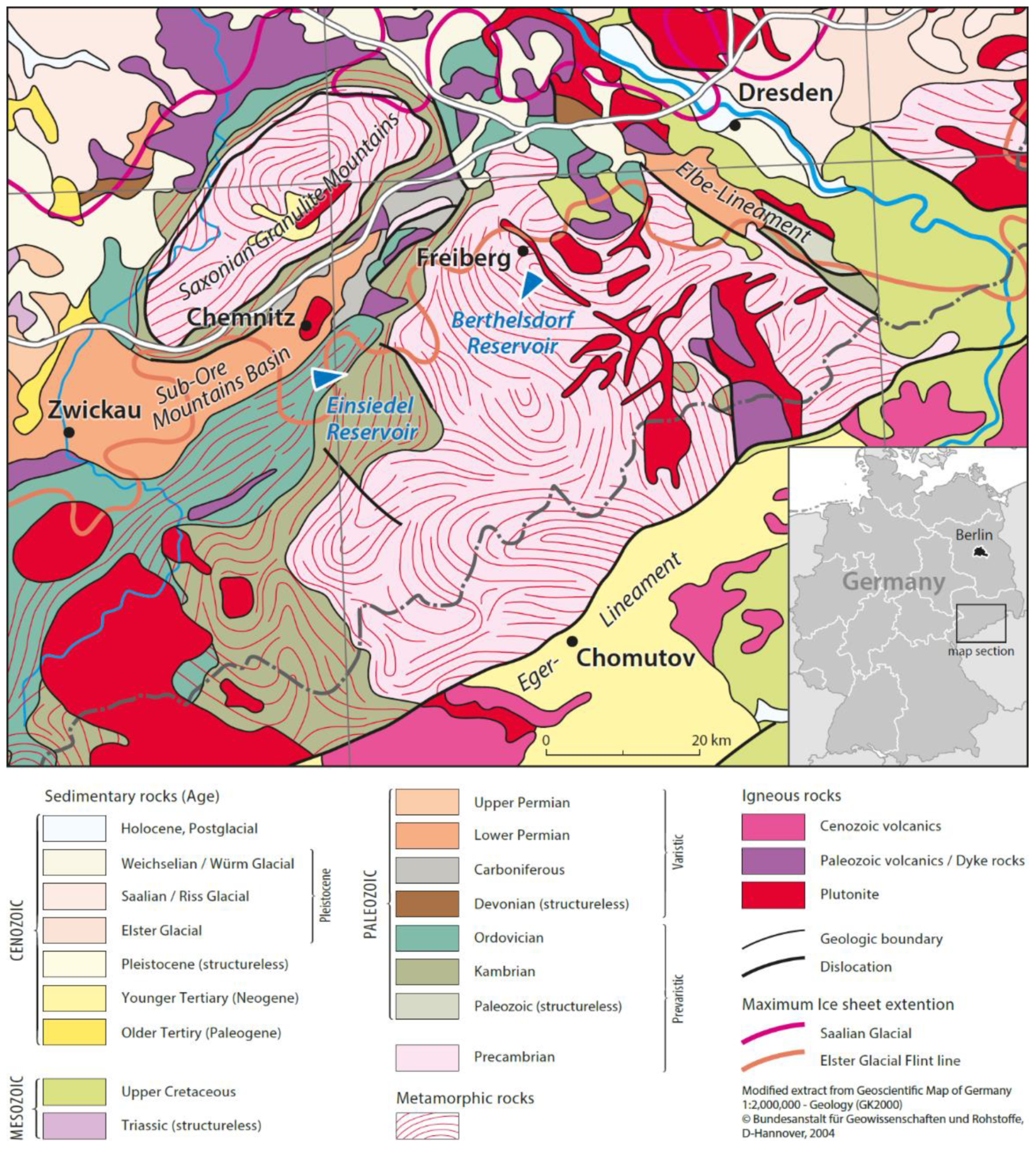
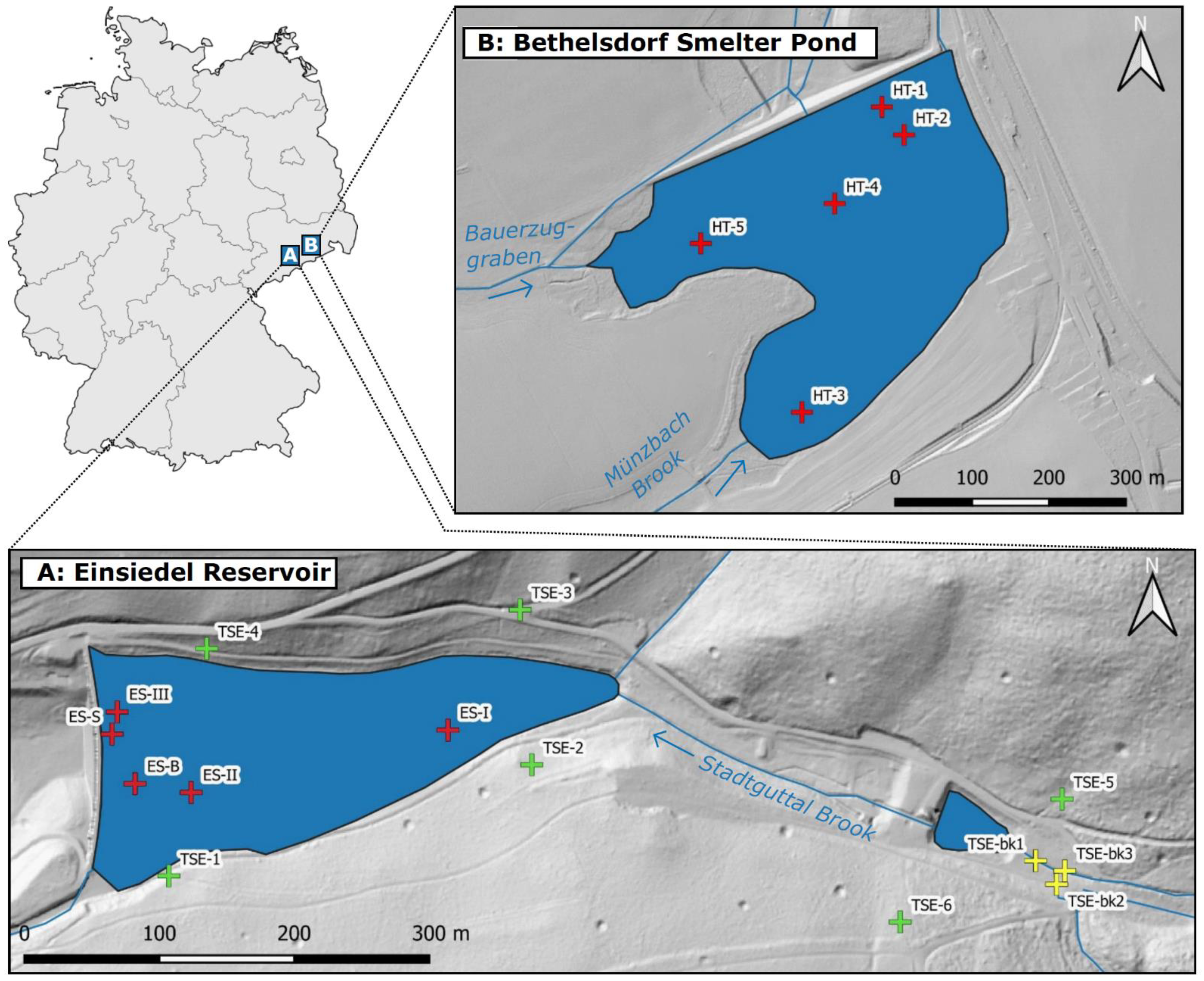
2.1. Field Campaign and Sample Collecting

Sampling of reservoir sediments took place in both drained reservoirs in late summer 2018. To ensure the representativeness of the sampling, samples were collected from areas near the dams with sediment thicknesses >1 m, as well as from the back areas of the reservoir basins (<1 m sediment thickness) near the inflow of the main tributaries (Figure 2). All samples originated from lacustrine areas of the reservoirs. Samples from sediment profiles were basically divided into intervals of 5–10 cm. This allowed a detailed record of vertical variations in sediment quality. Conversely, only relatively small sample volumes could be obtained with this method; thus, the grain size analyses could only be performed on a reduced number of samples due to the high sample consumption. In the Einsiedel Reservoir, a total of five sediment cores were taken near the dam (i.e., ES-S, ES-B and ES-III), near the centre (i.e., ES-II) and near the inflow (i.e., ES-I) of the reservoir with the help of PVC pipes, with sediments collected from depths of 20–40 cm. The sediment cores were subdivided into a total of 18 sediment sections with 5−10 cm thickness. In spring 2019, an additional field campaign took place around the Einsiedel Reservoir to collect soil samples from the surrounding watershed and sediment samples from the main tributaries. Soils were sampled from 6 plots (1 × 1 m), where an input of soil components into the reservoir basin due to the fact of erosion was assumed to be possible. Within each plot, the soil types were classified [34] before samples were taken from the topsoil (0−10 cm) and subsoil (11−25 cm) horizons at three locations and combined into one composite sample per depth level (12 composite samples in total). The organic cover layer, which was dominated by needle litter, was removed before the topsoil samples were collected. Brook sediments (3 samples) were collected from 0 to 15 cm depth as disturbed samples with a shovel in flow-calmed areas of the main tributaries.
The Berthelsdorf Smelter Pond (BSP) was investigated using five sediment profiles sampled with a Pürckhauer drilling rod and a PVC pipe. The samples were collected at the backwater location of the basin (i.e., HT-3 and HT-5), the middle of the reservoir (i.e., HT-4) and near the reservoir outlet (i.e., HT-1 and HT-2). Depending on the location, the sediment profiles reached thicknesses of 20−100 cm and were divided into sections of 10 cm, resulting in a total of 36 samples. Soil sampling in the catchment of the BSP was not carried out because the balanced relief did not allow for the tracing of potential sediment sources without further effort.

2.2. Laboratory Analyses

All samples were air-dried, homogenised in a porcelain mortar and sieved to <2 mm [37]. Grain size fractions of the reservoir sediments and catchment soils were analysed by a combined sieve and sedimentation analysis. The fine fraction (<63 µm) was determined using a PARIO analyser (Meter Group AG, Munich, Germany). This system automatically determines the particle distribution by measuring the suspension pressure after the samples are prepared according to DIN ISO 11277 [38]. Before analysis, the organic matter of the air-dried samples was destroyed by the addition of a 30% H2O2 solution. After a 16 h pre-reaction at room temperature, the samples were slightly heated until the release of CO2 from the samples was complete. The mineral soil particles were subsequently dispersed with a Na4P2O7 solution overnight before grain size analysis was performed. To analyse the soil organic matter content, aliquots of the sieved (<2 mm) and homogenised samples were dried overnight in an oven at 105 °C. Soil organic matter was then determined gravimetrically based on loss on ignition at 550 °C [39]. The pH value was measured in a solution of 0.01 M CaCl2 (m/V = 1:2.5) [37] with a pH electrode (SenTix 41, WTW, Weilheim, Germany). The electric conductivity was determined using an electrode (Tetra Con 325, WTW, Weilheim, Germany) after the samples were stirred in deionised water (m/V = 1:5) for 2 h [40]. Metal(loid)s were quantified according to DIN EN ISO 17294-2 [41] by inductively coupled plasma mass spectrometry (ICP–MS; XSERIES 2; Thermo Fisher Scientific, Bremen, Germany). For this purpose, 1 g of each sieved (<2 mm) sample was heated (85–90 °C) in aqua regia for 2 h, filtered and diluted with ultrapure water before analysis [42]. Each sample was measured three times for concentrations of arsenic (As), cadmium (Cd), chromium (Cr), copper (Cu), iron (Fe), mercury (Hg), manganese (Mn) nickel (Ni), lead (Pb), vanadium (V) and zinc (Zn). Measuring values with a relative deviation of more than 20% from the average value were excluded.

2.3. Data Interpretation

The measured metal concentrations were compared with regional geogenic background values provided by the Saxon Federal Agency of Environment, Agriculture and Geology [43] (Tables S1 and S2). These background values are specified on geology, soil horizon and land use. Since they do not include specific values for reservoir sediments, the comparison was conducted by selecting background values matching the prevailing geology and the dominant land use of a respective reservoir (Einsiedel Reservoir: background values for soils from phyllite dominated by forestry; BSP: background values for soils from gneiss used by agriculture). Since it is likely that the reservoir sediments mostly originate by erosion of topsoil material, the background values of the topsoils were considered for the comparison with metal(loid) concentrations of the reservoir sediments.

2.4. Statistical Operations

Statistical analyses were performed in Microsoft Excel 2013 (Microsoft; Redmond, WA, USA), R (R Core Team, 2020) and RStudio (version 3.4.1; RStudio Inc., Boston, MA, USA). Data were tested for normal distribution using the Kolmogorov–Smirnov test. After mostly finding a non-normal distribution, correlation analyses were performed using the Spearman rank correlation [44]. A Spearman rank correlation coefficient close to 1 indicates a strong positive correlation, while a correlation coefficient close to −1 indicates a strong negative correlation. The p-value determined during the correlation analysis was used as an indicator for the reliability of the calculated correlation coefficient. A result was considered significant when the p-value was equal to or less than 0.05. Spearman rank correlation coefficients with a p-value > 0.05 were excluded from data interpretation.

3. Results

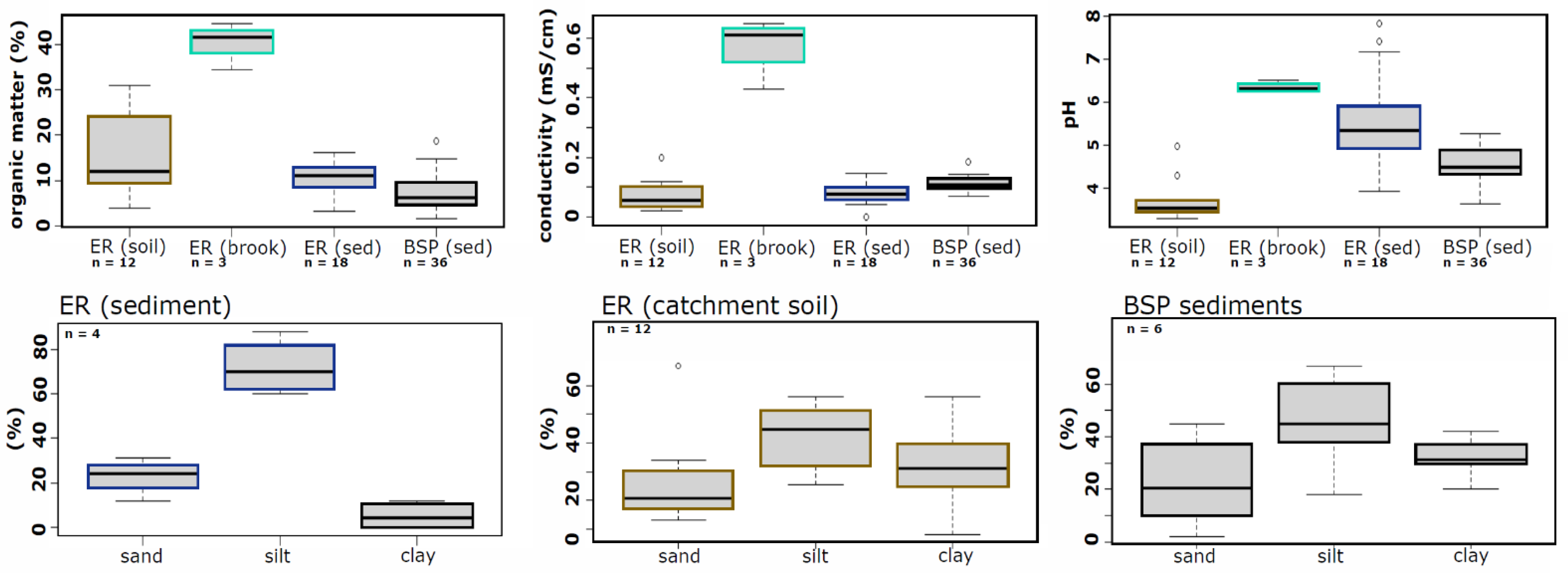
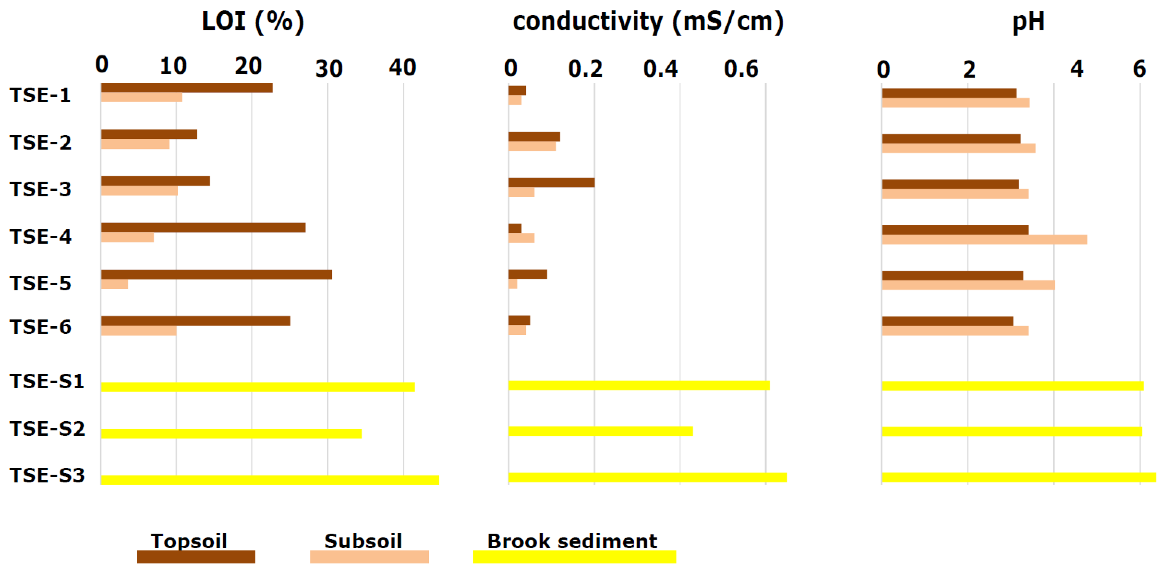
3.1. Physicochemical Properties

The potentially high sink function of both reservoirs for metal(loid)s was indicated by fine-grained, organic-rich sediments (Figure 3). In the sediment cores of the Einsiedel Reservoir, silt (median: 67.5%) was the dominant grain size fraction, while the percentages of sand (median: 29%) and clay (median: 4.5%) were clearly lower. With higher amounts of clay (median: 31.1%) and high proportions of silt (median: 47.0%) and sand (median: 17.8%), the BSP sediments were characterised by a loamier texture. However, it should be noted that grain size analyses were only conducted on a reduced number of samples. With regard to the catchment soils, silt (median: 43.0%) was the dominant grain fraction, followed by clay (median: 29.9%) and sand (median: 21.4%).
The organic matter content in the Einsiedel Reservoir varied between 3.2% and 16.2%, had a relatively high median value (11.0%) and was possibly favoured by the organic-rich soils of the forested catchment. Organic matter in the BSP sediments, which varied from 1.6% to 18.8%, reached a clearly lower median value (6.3%). Both reservoirs’ sediments frequently showed a tendency for organic matter content to decrease with increasing sediment depth, which may be due to both the biodegradation and transformation processes of organic material. The organic content in the studied soil profiles at the Einsiedel Reservoir ranged from 12.8% to 30.6% in the topsoils and from 3.5% to 10.8% in the subsoils. The organic matter content in the brook sediments was noticeably higher than in the catchment soils and reached values between 34% and 45% (Figure 4).
The pH values in the BSP sediments (pH 3.6–5.3) indicate strongly acidic conditions, whereas the Einsiedel Reservoir sediments (pH 3.9–7.8) were slightly acidic and in one case even slightly alkaline. The electric conductivity was relatively low in both areas, which may be favoured by the dominance of metamorphic, felsic parent rocks in both catchments. It was a little higher in the BSP sediments (0.07–0.18 mS/cm) than in the Einsiedel Reservoir sediments (0.04–0.15 mS/cm).
The differences in pH between the topsoils (tos) (pH 3.1–3.4) and the subsoils (sus) (pH 3.4–4.8) were relatively small. The electrical conductivity was generally higher in the topsoils (0.03–0.2 mS/cm) than in the subsoils (0.02–0.1 mS/cm). The acidity of the brook sediments was noticeably lower than in the soil or sediment samples and ranged from pH 6.1 to pH 6.4. The electric conductivity of the brook sediments was relatively low, ranging from 0.43 mS/cm to 0.65 mS/cm, but it was still higher than for the soil samples.

3.2. Metal(loid) Concentrations

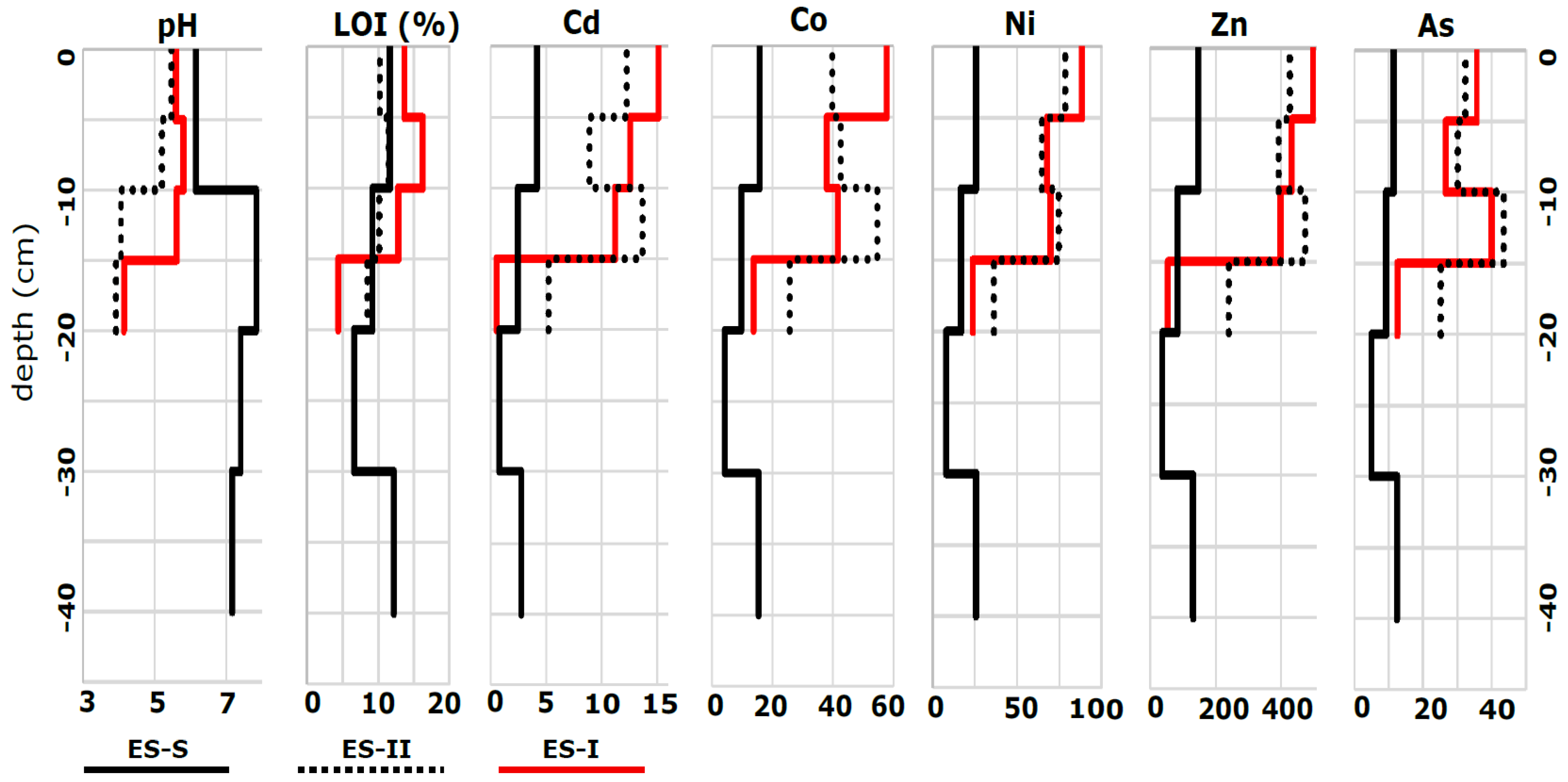
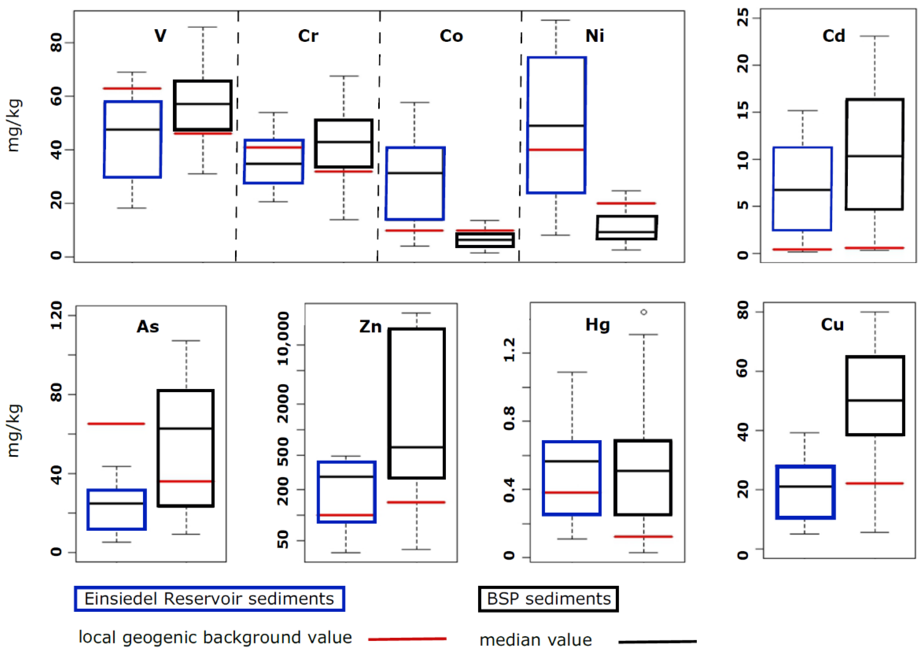
3.2.1. Einsiedel Reservoir

The median metal(loid) concentrations of the Einsiedel Reservoir sediments exceeded the geogenic background values for Cd, Hg, Ni, Zn and Co [43] (Table 2). The element concentrations of the brook sediments showed the same tendency toward elevated values, including the concentrations of Cu but with the exception of Hg. The measured median element concentrations in the soil samples were generally lower, and only slightly elevated concentrations were found for Hg, Pb and Co (Table 3).
Sediment core ES-I (Figure 5), located near the inflow of the Stadtguttal Brook, showed a simultaneous decrease in metal(loid) concentrations, pH value and organic matter beyond a depth of 15 cm, coinciding with the transition of lacustrine sediments to sediments of the former floodplain. Core ES-II, sampled from the middle of the reservoir, showed a strong enrichment for most of the metal(loid)s between 10 and 15 cm depth. Cores sampled near the dam (i.e., ES-S, ES-B and ES-III) were characterised by mostly lower concentrations and by less pronounced vertical variations in metal(loid) concentrations as exemplified by core ES-S.
ES-I contained the highest concentrations of Hg (mean: 0.71 mg/kg; median: 0.82 mg/kg). The highest concentrations of Co (mean: 40.7 mg/kg; median: 41.2 mg/kg) and As (mean: 32.7 mg/kg; median: 31.2 mg/kg) were present in the core ES-II. ES-III had the highest mean concentrations of V (64.6 mg/kg), Cr (53.5 mg/kg), Ni (78.4 mg/kg) and Zn (433 mg/kg). The catchment soils of the Einsiedel Reservoir (Figure 6) tended to have higher concentrations of V, Pb, Cu, Hg and As in topsoil areas, while the concentrations of Cr, Fe, Co and Ni were mostly higher in subsoils. The brook sediments were characterised by distinctively higher concentrations of Cd, Co, Cu and Zn, while As and Pb reached averagely higher concentrations in topsoils.

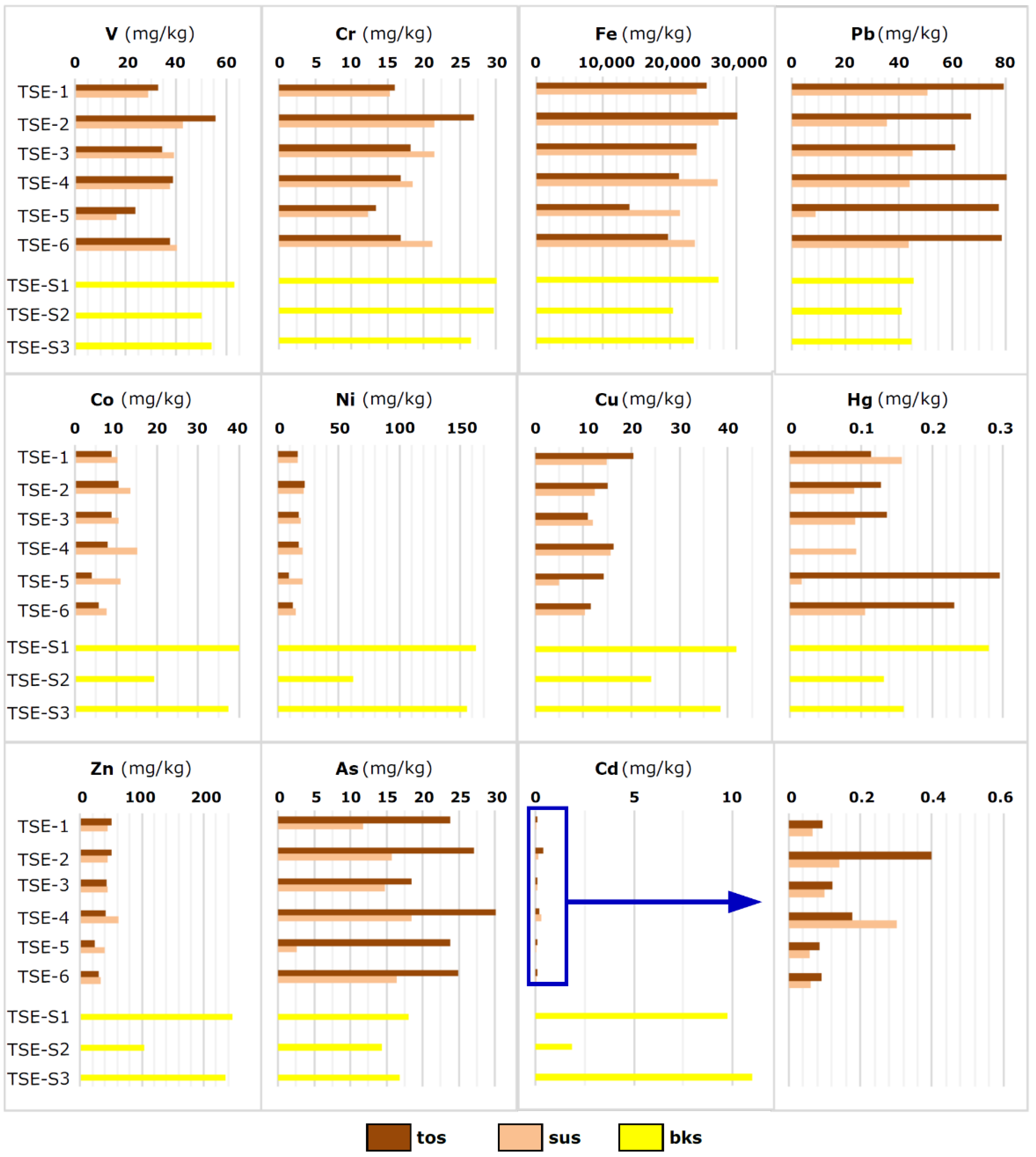
3.2.2. Berthelsdorf Smelter Pond (BSP)

With the exception of Ni and Co, the metal(loid) concentrations in the sediments of the BSP (Table 4) clearly exceeded the respective geogenic background values [43] and the mean element concentrations found in sediments of the Einsiedel Reservoir (Table 2).
Most of the sediment cores of the BSP showed the highest metal(loid) concentrations in deeper sediment layers. In comparison, HT-2 displayed the highest median concentrations of V (70.8 mg/kg), Cr (59.2 mg/kg), Co (10.3 mg/kg), Ni (16.1 mg/kg) and Hg (0.63 mg/kg). The highest median concentrations of Cu (187 mg/kg), Zn (18,435 mg/kg), As (811 mg/kg), Cd (29.6 mg/kg) and Pb (591 mg/kg) were found in core HT-5. In summary, the highest concentrations of highly enriched elements in the BSP sediments were mostly located close to the tributary Bauernzuggraben (i.e., HT-5), while less-enriched elements reached their maxima close to the dam (i.e., HT-2).
Sediments of the BSP generally exceeded the geogenic background of V, Cr, Hg, Cu, Cd, As and Zn (Figure 7). In comparison, the analysed concentrations of As, Cu and Zn in the BSP were significantly higher, although the geogenic background values [43] for the BSP catchment (gneiss) were lower than for the catchment of the Reservoir Einsiedel (phyllite), with the exception of Cd and Zn. The concentrations and variations of Co and Ni, oppositely, were higher in the sediments of the Einsiedel Reservoir. In the Einsiedel Reservoir sediments, the geogenic background values of Hg, Ni and Zn were slightly exceeded (i.e., background was between the 25th and 50th percentile), while Cd and Co significantly exceeded (i.e., background value < 25th percentile) the geogenic background.

3.2.3. Correlation Analysis

Moderate to strong positive correlations between organic matter content (LOI) and most metal(loid) concentrations, as well as between the metal(loid) concentrations themselves, were found for the Einsiedel Reservoir sediments (Table 5). Exceptions to these correlations were the concentrations of Cr, Fe and V, which were inversely negatively correlated with pH and positively correlated with electrical conductivity (Table 5, Figure S5). The strong negative correlation between Fe and pH can be described as an effect of Fe oxidation during drying of the Einsiedel Reservoir sediment samples. This tendency did not occur in the soils of the reservoir catchment because Fe was already largely oxidised in the soils. The strongest correlations between individual metal(loid)s were found between As, Cd, Co, Ni and Zn.
In catchment soils, the positive correlations between the metal(loid)s themselves were less strong and frequent than in the reservoir sediments (Table 6). Stronger positive correlations between the organic matter content and metal(loid) concentrations were limited to As and Pb concentrations (Table 6, Figure S6). Positive correlations between Pb and organic matter were typical for forest soils, since atmospherically deposited As and Pb are preferentially accumulated in organic-rich topsoil layers [45]. In contrast, moderate and strong negative correlations existed between organic matter and concentrations of Ni and Co, consistent with Co and Ni having higher concentrations in subsoil layers, reflecting a geogenic origin or a migration from above. Clay content was positively correlated with As and Pb concentrations, while it was negatively correlated to Ni and Co.
For BSP sediments, weak to moderate positive correlations were found between Cd, Cr, Ni and V concentrations and the amount of organic matter (Table 7, Figure S7). Weak to moderate negative correlations occurred between pH and the concentrations of As, Cd and Fe. Similar to the Einsiedel Reservoir sediments, moderate to strong positive correlations occurred between most of the investigated metal(loid)s. The strongest positive correlations occurred between the concentrations of Co, Cr, Ni and V, while the correlations between these elements and other metal(loid)s were noticeably lower (correlation coefficients < 0.6). Independently of this, the concentrations of As, Cd, Cu, Fe, Hg and Zn showed moderate to strong correlations (correlation coefficients ≥ 0.59) with each other.

4. Discussion

4.1. Metal(loid)s in Reservoir Sediments

The fine texture and the high concentrations of organic matter of the reservoir sediments generally favours a high sorption potential for metal(loid)s [46], which, however, was reduced by the acidic conditions in the BSP sediments. The differences in acidity between the two reservoirs may be influenced by intense weathering of the biotite gneisses, biotite-two-feldspar gneisses and quartzites in the BSP catchment area [25], which have been exposed to the surface longer than the rocks and soils of the Einsiedel Reservoir catchment. Although the pH of the BSP sediments was weakly correlated with Fe concentrations, which can be interpreted as an indication of acidification due to the oxidation processes during sediment drying [47], this process alone seems insufficient to explain the high acidity of the BSP samples. Since the maximum concentrations of As (34,661 mg/kg), Cd (124 mg/kg) and Zn (23,653 mg/kg) correspond to concentrations of raw ores, it is likely that the BSP sediments partially contained residual products of ore processing. Since the local ores are often sulfidic [24], the low pH of the BSP sediments can be explained by the oxidation of sulfidic compounds [48]. In the case of sediment dredging, the high acidity of the BSP sediments favours the release of metal(loid)s, which means the sediments have a high potential to be a source of contaminants during removal.
Metal(loid) enrichments in both reservoirs were assumed to be favoured by a relatively high geogenic background [49]. While stronger enrichments of metal(loid)s in the Einsiedel Reservoir sediments were limited on Cd, Co, Ni and Zn (see Section 4.2), the multi-element enrichments in the BSP sediments can only be explained by intensive anthropogenic metal(loid) inputs. It is likely that the BSP was exposed to both fluvial metal(loid) inputs, as described for the Malter Reservoir (Ore Mountains) [50], and centuries of atmospheric deposition [51]. In the current study, enhanced metal(loid) enrichment due to historic metal(loid) inputs into the BSP sediments was revealed by the frequent occurrence of metal(loid) maximum concentrations at depths of 20–30 cm, which is consistent with dams of the Ruhr district [52]. A comparison of the analysed metal(loid) concentrations with the sediments of other reservoirs is presented in Table 8 and can be continued based on further studies [23,53].

4.2. Metal(loid) Concentrations in Soils and Brook Sediments of the Einsiedel Reservoir

The metal(loid) concentrations of the soils of the Einsiedel catchment were mostly at a relatively low level. This may be due in part to the low pH of the soils, which favoured the migration of Cd, Co, Ni and Zn to deeper soil parts and to groundwater. The much higher concentrations of these elements in brook sediments provide evidence of their transport to morphologic depressions and their accumulation in surface water sediments under neutral pH conditions, leading to a depletion in terrestrial soils [4]. The metal concentrations in tributary brooks were approximately the same as those in the reservoir sediments, because the brooks act as “collectors” or temporary sinks for element flows from the catchment [56]. Because of their transitional position between the catchment and the reservoir, they also act as a source of sediment and metal(loid)s for the reservoir. At least for Cd, Co, Ni and Zn, which were characterised by high mobility under acidic conditions [57], the forested catchment soils of the Einsiedel Reservoir represent a source for these metals rather than a sink. The origin of the metals could be geogenic, although enrichment in topsoils, as found for As and Pb, should rather be due to the fact of atmospheric deposition.

4.3. Evaluation of the Results Based on Lawful Standards

There are no legal requirements for inorganic pollutants in reservoir sediments in Germany as long as the sediments are not removed from the reservoir bottom. Therefore, we considered comparing metal(loid) concentrations in reservoir sediments with selected (I) precautionary values (Vorsorgewerte), (II) examination values (Prüfwerte) and (III) action values (Maßnahmenwerte) according to the German Federal Soil Protection Ordinance (Table 9).
The fact that the geogenic background values of phyllite topsoils (Table 3) naturally exceed the precautionary values in the case of Pb (i.e., 86 mg/kg) indicates the relatively small gap between the legal limits and the geogenic background values of the study areas. It is therefore not surprising that the mean concentrations of sediments from both reservoirs (Einsiedel in the case of Cd, Hg and Zn; BSP in the case of Cd, Cu, Hg, Pb and Zn) exceeded the precautionary values, which largely restricts the reuse of dredged reservoir sediments as soil material. None of the metal(loid) concentrations in the sediment and soil samples from the Einsiedel Reservoir exceeded the examination or action thresholds. However, high percentages of the BSP sediment samples exceeded the action values, which was observed for As (58%), Cd (12%), Cu (3%) and Pb (9%). The analysed Hg and Ni concentrations were below these legal limits. The results show that the Einsiedel Reservoir sediments would not be considered as a “harmful changed soil” or a “contaminated site” if they were park or recreational soil. However, because they naturally exceeded the precautionary values, use as soil material is not necessarily possible. Oppositely, due to the multiple exceedances of the action values, the BSP sediments are equivalent to “harmful changed soil material”.

4.4. Evaluation of the Correlation Analyses

The numerous positive correlations in the reservoir sediments between the metal(loid) concentrations themselves and between metal(loid)s and organic matter content may rely on the same source of the metal(loid)s investigated and/or preferential adsorption on organic matter [1,2,3,4,5]. The correlations between organic matter and metal(loid) concentrations were comparatively lower in the BSP sediments, probably due to the less intense adsorption of metal(loid)s by organic compounds based on their lower content. While the forested and sloping catchment of the Einsiedel Reservoir provided high amounts of organic matter that was deposited into the reservoir, the comparatively lower organic matter contents in the BSP sediments can be explained by a high proportion of less organic-rich agricultural soils in the catchment. Negative correlations between sediment pH and metal(loid) concentrations varied between the Einsiedel Reservoir and BSP samples. As mentioned above (Section 3.2.3), the negative correlation between Fe and pH was interpreted as a result of the oxidation of Fe during sediment drying. In the Einsiedel Reservoir sediments, the negative correlations between pH and concentrations of Cr, Fe and V could be due to the preferential association of these lithogenic elements, which is at least supported by the fact that Fe, Cr and V were strongly positively correlated with each other. A primarily lithogenic origin of Cr and V was evidenced by the fact that the concentrations of both elements in the Einsiedel Reservoir samples fell below or only slightly exceeded their geogenic background. However, in the BSP sediments, Fe seemed to be more associated with Cd and As as indicated by the high positive correlations. On the one hand, this phenomenon can be explained by the ability of Fe compounds to preferentially adsorb high amounts of As and Cd [58,59]. On the other hand, it also seems possible that these metal(loid)s rely on the same component of BSP sediments such as residues of Fe-, As- and Cd-rich ores.
In contrast, the soil samples were more strongly characterised by soil profiling, which was expressed in less frequent correlations between the metal(loid)s themselves than found for the reservoir sediments. Horizon-specific differences were evident in the strong positive correlations between organic matter and As and Pb. This phenomenon relies on the accumulation of both elements in organic and fine-particle-rich topsoils after atmospheric deposition [45] and has also been observed in catchment soils of the Klingenberg Reservoir [60]. In contrast, the fact that Co and Ni were negatively correlated with organic matter and clay content and positively correlated with soil pH proves the enrichment of both elements in the subsoil horizons. The lithogenic elements Cr and V were strongly positively correlated in catchment soils, indicating that no significant redistribution or separation of concentrations of the two elements occurred during erosion, transport and deposition as reservoir sediment. Oppositely, the soils showed no correlation between the concentrations of As and Co, which were strongly positively correlated in the Einsiedel Reservoir sediments, which could be due to the similar adsorption behaviour of both elements after deposition as reservoir sediment.

4.5. Sources and Sinks of Metal(loid)s

Due to the relatively low metal(loid) contents in the catchment soils of the Einsiedel Reservoir and the absence of anthropogenic point sources, the accumulation of Cd, Co, Ni and Zn in the reservoir sediments can be attributed to inputs from the tributaries. This is evidenced by the elevated concentrations of these elements in brook sediments, where release from the catchment soils was likely the only relevant source, favoured by the soil acidity and sloping relief. In contrast, these elements were slightly depleted from catchment soils due to the long-term processes of leaching and washout. The source of Hg, which was also enriched in the reservoir sediments but had equally low concentrations in soils and brook sediments, remains unclear. In addition to tributary brooks, another input could be the water inflow from the Neuzehnhain 1 Reservoir and other reservoirs of the Middle Ore Mountain dam chain via pipelines. However, this requires further investigation.
In addition to an elevated geogenic background, the metal(loid) enrichment in the BSP sediments was impacted for centuries by mining and smelting in the Freiberg mining district. Because of the agricultural catchment area, it can be assumed that the metal(loid) enrichment was less due to the leaching-related input from acidified catchment soils. Rather, anthropogenically released metal(loid)s are expected to have entered the BSP directly via the impounded brooks and artificial ditches as well as through atmospheric depositions. In the BSP catchment, a heap from an abandoned mine could be a significant metal(loid) source entering the reservoir via the Bauerzuggraben ditch and could be reflected in the high concentrations of As, Cu and Pb in core HT-5. Another potential source of atmospheric deposition is the “Muldenhütten” smelter, located only 3.3 km from the reservoir. It was active between 1318 and 1969 and smelted ores containing Ag, Pb, Zn, Cu and As [61]. The combination of these natural and anthropogenic metal(loid) sources, favoured by high levels of potential metal(loid) adsorbents, such as clay minerals and organic material, can explain the generally high metal(loid) concentrations in the BSP sediments.

5. Conclusions

The study of metal(loid) concentrations in the catchment soils and the sediments of tributary brooks provided deep insight into the processes regarding the source and sink functions of the reservoir sediments. Soils of the catchment can act as sources for comparatively mobile elements (i.e., Cd, Co, Ni and Zn), depending on their sorption capability and acidity, while elements with higher binding affinity (i.e., As and Pb) are retained and accumulated in topsoils. Elements transferred into tributary brook sediments can be transported to the reservoirs, which function predominately as metal(loid) sinks. Another reason for the source function of the catchment and the sink function of the reservoirs is the general decrease in watershed relief, runoff, and, thus, drainage capacity.
The metal(loid) concentrations in the sediments of the Einsiedel Reservoir provide evidence of this sink function. The hazard potential of the enriched metal(loid)s is low as long as the sediments remain undisturbed. Because of the permanent monitoring of stored water for metal(loid) content and the high adsorption capacity of the sediments, there is no risk to water use, including drinking water use, from the Einsiedel Reservoir.
Due to the high metal(loid) concentrations in the sediments of the BSP, which partly exceeded both the examination and the action values of the German Federal Soil Protection Ordinance, drinking water use is out of the question. Dredging of sediments from the BSP is not recommended due to the high release potential for metal(loid)s under changing redox conditions. If dredging of sediments is necessary (e.g., due to the fact of reservoir expansion), detailed analyses of metal(loid) concentrations in the sediment are recommended to separate moderately contaminated sediments from hotspots of metal(loid) contamination.
Since the processes of adsorption and desorption of metal(loid)s can be affected by the dynamics of water level and temperature, it seems advisable to conduct further sampling campaigns addressing the effects of climate change on the hazard potential of reservoir sediments.

Supplementary Materials

The following supporting information can be downloaded at: https://0-www-mdpi-com.brum.beds.ac.uk/article/10.3390/app12136354/s1, Figure S1: Primary uses of reservoirs in Saxony; Figure S2: Dam of the Einsiedel Reservoir during excavation, view direction south; Figure S3: View from the dam of the Berthelsdorfer Hüttenteich over the partly drained reservoir, view direction south–southeast; Figure S4: Schematic diagram of the research approach; Figure S5: Bivariate diagram of Co-As from the Einsiedel Reservoir sediments; Figure S6: Bivariate diagrams of the LOI-Co/Pb and clay content-Co/As from the Einsiedel Reservoir catchment soil; Figure S7: Bivariate diagram of the LOI-Cr/V content from the Berthelsdorf Reservoir sediments. Table S1: Geogenic background values for organic cover layers (ocl), topsoils (tos) and subsoils (sus) of Saxon soils from phyllite used by forestry, status May 2015. Table S2: Geogenic background values for organic cover layers (ocl), topsoils (tos) and subsoils (sus) of Saxon soils from gneiss, status May 2015.

Author Contributions

Conceptualisation, C.O. and T.B.; methodology, T.B. and C.O.; software, T.B.; validation, T.B. and C.O.; formal analysis, T.B. and C.O.; investigation, T.B., J.H., C.O. and N.Z.; resources, T.B. and C.O.; data curation, T.B., J.H., C.O. and N.Z.; writing—original draft preparation, C.O. and T.B.; writing—review and editing, C.O., T.B. and J.H.; visualisation, T.B.; supervision, C.O.; project administration, C.O.; funding acquisition, T.B. and C.O. All authors have read and agreed to the published version of the manuscript.

Funding

This research received no external funding.

Data Availability Statement

Not applicable.

Acknowledgments

The authors would like to thank the Saxon Reservoir Administration (Sächsische Landestalsperrenverwaltung, LTV) for the opportunity to carry out the field analyses within and around the studied reservoirs, for its general cooperation and for its approval of this publication. We also thank the Federal Agency of Geoscience and Resources (Bundesanstalt für Geowissenschaften und Rohstoffe) for the use and modification possibility of the Geoscientific Map of Germany. We also thank our colleague, Collin J. Weber, for his active participation during the field work at the Berthelsdorf Reservoir. The authors also would like to thank the unknown reviewers for their comments and recommendations. We also thank our colleague, Hadi Salim Aoubid Allafta, for his careful proofreading. Open Access funding provided by the Open Acess Publication Fund of Philipps-Universität Marburg with support of the Deutsche Forschungsgemeinschaft (DFG, German Research Foundation).

Conflicts of Interest

The authors declare no conflict of interest.

References

  1. Blume, H.-P.; Brümmer, G.W.; Fleige, H.; Horn, R.; Kandeler, E.; Kögel-Knabner, I.; Kretzschmar, R.; Stahr, K.; Wilke, B.M. Scheffer/Schachtschabel Soil Science; Springer: Berlin/Heidelberg, Germany, 2016; 618p. [Google Scholar]
  2. Alloway, B.J. Schwermetalle in Böden; Springer: Heidelberg/Berlin, Germany, 1999; pp. 41–61. [Google Scholar]
  3. Salomons, W.; Förstner, U. Metals in the Hydrocycle; Springer: Heidelberg/Berlin, Germany, 1984; pp. 63–92. [Google Scholar]
  4. Opp, C. Schwermetalle. In Analyse und ökologische Bewertung der Landschaft, 2nd ed.; Schreiber, K.-F., Bastian, O., Eds.; Spektrum: Heidelberg/Berlin, Germany, 1999; pp. 239–246. [Google Scholar]
  5. Hahn, J. Schwermetall-Status und Schwermetallmobilität in Auenböden und Stauseesedimenten unter besonderer Berücksichtigung von Durchfeuchtungs-und Wasserstandsänderungen. Ph.D. Thesis, FB Geographie, Philipps-Universität Marburg, Germany, 2014. Available online: http://archiv.ub.uni-marburg.de/diss/z2014/0103/pdf/djh.pdf (accessed on 23 January 2022).
  6. Opp, C.; Hahn, J.; Zitzer, N.; Laufenberg, G. Heavy metal concentrations in pores and surface waters during the emptying of a small reservoir. J. Geosci. Environ. Prot. 2015, 3, 66–72. [Google Scholar] [CrossRef]
  7. Hahn, J.; Opp, C.; Evgrafova, A.; Groll, M.; Zitzer, N.; Laufenberg, G. Impacts of dam draining on the mobility of heavy metals and arsenic in water and basin bottom sediments of three studied dams in Germany. Sci. Total Environ. 2018, 640–641, 1072–1081. [Google Scholar] [CrossRef] [PubMed]
  8. Förstner, U. Bindungsformen von Schwermetallen in Sedimenten und Schlämmen: Sorption/Mobilisierung, chemische Extraktion und Bioverfügbarkeit. Fresenius Z. Anal. Chem. 1983, 316, 604–611. [Google Scholar] [CrossRef]
  9. Tschopp, J. Die Verunreinigungen der Seen mit Schwermetallen—Modelle für die Regulierung der Schwermetallkonzentrationen. Ph.D. Thesis, ETH Zürich, Zürich, Switzerland, 1979. Available online: https://www.dora.lib4ri.ch/eawag/islandora/object/eawag%3A13197/datastream/PDF/Tschopp-1979-Die_Verunreinigung_der_Seen_mit-%28published_version%29.pdf (accessed on 24 January 2022).
  10. Audry, S.; Schäfer, J.; Blanc, G.; Jouanneau, J.M. Fifty-year sedimentary record of heavy metal pollution (Cd, Zn, Cu, Pb) in the Lot River reservoirs (France). Environ. Pollut. 2004, 132, 413–426. [Google Scholar] [CrossRef] [PubMed]
  11. Auerswald, K. Feststofftransport in Fließgewässern. In Handbuch der Bodenkunde, 3rd ed.; Horn, R., Blume, H.P., Felix-Henningsen, P., Fischer, W., Frede, H.G., Stahr, K., Eds.; Ecomed: Landsberg/Lech, Germany, 1997; Section 6.3.4; pp. 1–12. [Google Scholar]
  12. Loska, K.; Wiechula, D. Application of principal component analysis for the estimation of source of heavy metal contamination in surface sediments from the Rybnik Reservoir. Chemosphere 2003, 51, 723–733. [Google Scholar] [CrossRef]
  13. Al-Taani, A.A.; Batayneh, A.T.; El-Radaideh, N.; Ghrefat, H.; Zumlot, T.; Al-Rawabdeh, A.M.; Al-Momani, T.; Taani, T. Spatial distribution and pollution assessment of trace metals in surface sediments of Ziqlab Reservoir, Jordan. Environ. Monit. Assess. 2015, 187, 32. [Google Scholar] [CrossRef]
  14. Franklin, R.L.; Teixeira Fávaro, D.I.; Damatto, S.R. Trace metal and rare earth elements in a sediment profile from the Rio Grande Reservoir, São Paulo, Brazil: Determination of anthropogenic contamination, dating, and sedimentation rates. J. Radioanal. Nucl. Chem. 2016, 307, 99–110. [Google Scholar] [CrossRef]
  15. Venelinov, T.; Mihaylova, V.; Peycheva, R.; Todorov, M.; Yotova, G.; Todorov, B.; Lyubomirova, V.; Tsakovski, S. Sediment Assessment of the Pchelina Reservoir, Bulgaria. Molecules 2021, 26, 7517. [Google Scholar] [CrossRef]
  16. Chheang, L.; Thongkon, N.; Sriwiriyarat, T.; Thanasupsin, S.P. Heavy Metal Contamination and Human Health Implications in the Chan Thnal Reservoir, Cambodia. Sustainability 2021, 13, 13538. [Google Scholar] [CrossRef]
  17. Szara-Bąk, M.; Baran, A.; Klimkowicz-Pawlas, A.; Tkaczewska, J.; Wojtasik, B. Mobility, ecotoxicity, bioaccumulation and sources of trace elements in the bottom sediments of the Rożnów reservoir. Environ. Geochem. Health 2021, 43, 4701–4718. [Google Scholar] [CrossRef]
  18. Reis, A.R.; Roboredo, M.; Pinto, J.P.R.M.; Vieira, B.; Varandas, S.G.P.; Fernandes, L.F.S.; Pacheco, F.A.L. Distribution and Potential Availability of As, Metals and P in Sediments from a Riverine Reservoir in a Rural Mountainous Catchment (NE Portugal). Int. J. Environ. Res. Public Health 2021, 18, 5616. [Google Scholar] [CrossRef] [PubMed]
  19. Federal Soil Protection Ordinance (Bundes-Bodenschutz- und Altlastenverordnung; BBodSchV). Bundesgesetzblatt. 16.7.1999, Teil I, Nr. 36, Bonn; pp. 1554–1582. Available online: https://www.bgbl.de/xaver/bgbl/start.xav?start=%2F%2F*%5B%40attr_id%3D%27bgbl199s1554.pdf%27%5D#__bgbl__%2F%2F*%5B%40attr_id%3D%27bgbl199s1554.pdf%27%5D__1655268421215 (accessed on 15 June 2022).
  20. German Federal Soil Protection Act (Gesetz zum Schutz vor schädlichen Bodenveränderungen und zur Sanierung von Altlasten]] (Bundes-Bodenschutzgesetz—BBodSchG). Bundesgesetzblatt. 17.3.1998, Teil I, Nr. 16, Bonn; pp. 502–510. Available online: https://www.bgbl.de/xaver/bgbl/start.xav?start=//*%5B@attr_id=%27bgbl198055.pdf%27%5D#__bgbl__%2F%2F*%5B%40attr_id%3D%27bgbl198s0502.pdf%27%5D__1655268953973 (accessed on 15 June 2022).
  21. LTV (Landestalsperrenverwaltung). Available online: www.talsperren-sachsen.de (accessed on 11 January 2022).
  22. Tarvainen, T.; Reichel, S.; Müller, I.; Jordan, I.; Hube, D.; Eurola, M.; Loukola-Ruskeeniemi, K. Arsenic in agro-ecosystems under anthropogenic pressure in Germany and France compared to a geogenic as region in Finland. J. Geochem. Explor. 2020, 217, 106606. [Google Scholar] [CrossRef]
  23. Ulrich, K.U.; Paul, L.; Hupfer, M. Pollutants in the sediments of water reservoirs. Wasser Boden 2000, 52, 27–32. [Google Scholar]
  24. Pälchen, W. Geologie von Sachsen II. Georessourcen, Geopotenziale, Georisiken; Schweizerbart’sche Verlagsbuchhandlung: Stuttgart, Germany, 2009; 307p. [Google Scholar]
  25. Sebastian, U. Die Geologie des Erzgebirges; Springer: Berlin/Heidelberg, Germany, 2013; 268p. [Google Scholar]
  26. LTV (Landestalsperrenverwaltung). Die Talsperre Einsiedel. 2014. Available online: https://publikationen.sachsen.de/bdb/artikel/22154 (accessed on 24 January 2022).
  27. Wagenbreth, O.; Wächtler, E. (Eds.) Der Freiberger Bergbau. Technische Denkmale und Geschichte; Springer Spektrum: Berlin, Germany, 2013; 504p. [Google Scholar]
  28. John, H.; Achziger, R.; Günther, A.; Richert, E.; Kugler, J.; Miekley, B.; Olias, M. Die Bergwerksteiche der Revierwasserlaufanstalt Freiberg als Lebensraum Einer Einzigartigen Teichbodenvegetation—Gebietshistorie und Vegetationsökologie als Basis für Nachhaltigen Naturschutz. 2010. Available online: https://www.dbu.de/OPAC/ab/DBU-Abschlussbericht-AZ-24796.pdf (accessed on 24 January 2022).
  29. LTV (o.J): Staumeisterei Revierwasserlaufanstalt Freiberg. Available online: https://publikationen.sachsen.de/bdb/artikel/17650 (accessed on 24 January 2022).
  30. Zänker, C.; Ullrich, E.; Schumann, H.-J.; Bachmann, F.; Fischer, F. Freiberg-Brander Bergbaurevier. 2020. Available online: https://osterzgebirge.org/gebiete/freiberg.html (accessed on 24 January 2022).
  31. LfULG (Sächsisches Landesamt für Umwelt, Landwirtschaft und Geologie). iDA-Digitale Bodenkarte 1:50.000. 2019. Available online: https://www.boden.sachsen.de/digitale-bodenkarte-1-50-000-19474.html (accessed on 24 January 2022).
  32. Claus, C. Heimatwerk Einsiedel—Die Talsperre Einsiedel. 2004. Available online: https://www.heimatwerk-einsiedel.de/altenhainer-allee/talsperre/ (accessed on 24 January 2022).
  33. Montan Region Krušné Hory—Erzgebirge. 2018. Available online: http://www.montanregion.cz/en/montanregion-en/freiberg-mining-landscape.html (accessed on 10 January 2022).
  34. IUSS Working Group WRB. World Reference Base for soil resources 2014, update 2015. International soil classification system for naming soils and creating legends for soil maps. In World Soil Resources Report 106; FAO: Rome, Italy, 2015; p. 106. [Google Scholar]
  35. Sächsisches Landesamt für Umwelt, Landwirtschaft und Geologie: Downloadbereich Digitale Höhenmodelle. Available online: https://www.geodaten.sachsen.de/downloadbereich-digitale-hoehenmodelle-4851.html (accessed on 15 January 2022).
  36. Sächsisches Landesamt für Umwelt, Landwirtschaft und Geologie: Geodatendownload des Fachbereichs Wasser. Available online: https://www.wasser.sachsen.de/geodatendownload-12834.html#a-12891 (accessed on 12 May 2022).
  37. Blume, H.-P.; Stahr, K.; Leinweber, P. Bodenkundliches Praktikum, 3rd ed.; Springer: Berlin/Heidelberg, Germany, 2010; 246p. [Google Scholar]
  38. DIN ISO 11277; (Deutsches Institut für Normung) Bodenbeschaffenheit-Bestimmung der Partikelgrößenverteilung in Mineralböden-Verfahren mittels Siebung und Sedimentation. Beuth: Berlin, Germany, 2002.
  39. DIN 18128; (Deutsches Institut für Normung) Baugrund-Untersuchung von Bodenproben-Bestimmung des Glühverlustes Bestimmung des Glühverlustes und der Trockenmasse. Beuth: Berlin, Germany, 2002.
  40. DIN ISO 11265; (Deutsches Institut für Normung) Bodenbeschaffenheit-Bestimmung der Spezifischen Elektrischen Leitfähigkeit. Beuth: Berlin, Germany, 1997.
  41. DIN EN ISO 17294-2; Wasserbeschaffenheit-Anwendung der induktiv gekoppelten Plasma-Massenspektrometrie (ICP-MS)-Teil 2: Bestimmung von Ausgewählten Elementen Einschließlich Uran-Isotope (ISO 17294-2:2016). Beuth: Berlin, Germany, 2017.
  42. DIN ISO 11466; (Deutsches Institut für Normung) Bodenbeschaffenheit: Extraktion in Königswasser löslicher Spurenelemente. Beuth: Berlin, Germany, 1995.
  43. LfULG. Hintergrundwerte für sächsische Böden-Angaben für Stoffgehalte, differenziert nach Substrat, Nutzung und Horizont. 2015. Available online: https://www.umwelt.sachsen.de/umwelt/download/boden/HGW_BO_SN_2015_KW.pdf (accessed on 24 January 2022).
  44. Duller, S. Einführung in die Nichtparametrische Statistik mit SAS, R und SPSS. Ein Anwendungsorientiertes Lehr-und Arbeitsbuch, 2nd ed.; Springer: Heidelberg/Berlin, Germany, 2018. [Google Scholar]
  45. Utermann, J.; Aydın, C.T.; Bischoff, N.; Böttcher, J.; Eickenscheidt, N.; Gehrmann, J.; König, N.; Scheler, B.; Stange, F.; Wellbrock, N. Heavy metal stocks and concentrations in forest soils. In Status and Dynamics of Forests in Germany. Ecological Studies (Analysis and Synthesis) 237; Wellbrock, N., Bolte, A., Eds.; Springer: Cham, Switzerland, 2019. [Google Scholar]
  46. Zhang, C.; Yu, Z.G.; Zeng, G.M.; Jiang, M.; Yang, Z.Z.; Cui, F.; Zhu, M.Y.; Shen, L.Q.; Hu, L. Effects of sediment geochemical properties on heavy metal bioavailability. Environ. Int. 2014, 73, 270–281. [Google Scholar] [CrossRef] [PubMed]
  47. Borma, L.D.S.; Ehrlich, M.; Barbosa, M.C. Acidification and release of heavy metals in dredged sediments. Can. Geotech. J. 2003, 40, 1154–1163. [Google Scholar] [CrossRef]
  48. Schippers, A. Biogeochemistry of metal sulfide oxidation in mining environments, sediments, and soils. In Special Paper 379: Sulfur Biogeochemistry-Past and Present 379; Geological Society of America: Boulder, CO, USA, 2004; pp. 49–62. [Google Scholar]
  49. Rank, G.; Kardel, K.; Pälchen, W.; Weidensdörfer, H. Soil Atlas of the Free State of Saxony, Part 3, Soil Measurement Program; Sächsisches Landesamt für Umwelt und Geologie: Freiberg, Germany, 1999. [Google Scholar]
  50. Müller, J.; Ruppert, H.; Muramatsu, Y.; Schneider, J. Reservoir sediment—A witness of mining and industrial development (Malter Reservoir, Eastern Erzgebirge, Germany). Environ. Geol. 2000, 39, 1341–1351. [Google Scholar] [CrossRef]
  51. Fiedler, H.; Klinger, L. The trace element situation in the forest soils of the eastern Ore Mountains. In Ways and Progress of Science: Contributions by Members of the Academy to the 150th Anniversary of its Founding; Haase, G., Eichler, E., Eds.; Saxon Academy of Sciences: Leipzig, Germany, 1996; pp. 679–697. [Google Scholar]
  52. Rosenbaum-Mertens, J. Sediments as Pollutant Archives. Changes in Heavy Metal Input into the Environment since 1945. High-resolution Investigations of Lake Sediments in Industrial Zones and Natural Areas. Ph.D. Thesis, University of Duisburg-Essen, Duisburg-Essen, Germany, 2003. [Google Scholar]
  53. Sojka, M.; Jaskuła, J.; Siepak, M. Heavy Metals in Bottom Sediments of Reservoirs in the Lowland Area of Western Poland: Concentrations, Distribution, Sources and Ecological Risk. Water 2019, 11, 56. [Google Scholar] [CrossRef] [Green Version]
  54. Junge, F.W. Schadstoffsenke Muldestausee—Aktuelles Potenzial und Jüngste Entwicklung seit 2002. 2013. Available online: http://elsa-elbe.de/massnahmen/fachstudien-neu/fachstudie-muldestausee.html (accessed on 26 January 2022).
  55. Wildi, W.; Dominik, J.; Loizeau, J.L.; Thomas, R.L.; Favarger, P.-Y.; Haller, L.; Perroud, A.; Peytreman, C. River, lake and reservoir sedimentation by heavy metals downstream from urban areas from Switzerland. Lakes Reserv. Res. Manag. 2004, 9, 75–82. [Google Scholar] [CrossRef]
  56. Hahn, J.; Bui, T.; Kessler, M.; Weber, C.J.; Beier, T.; Mildenberger, A.; Traub, M.; Opp, C. Catchment soil properties affect metal(oid) enrichment in reservoir sediments of German low mountain regions. Appl. Sci. 2022, 12, 2277. [Google Scholar] [CrossRef]
  57. Blake, L.; Goulding, K.W.T. Effects of atmospheric deposition, soil pH and acidification on heavy metal contents in soils and vegetation of semi-natural ecosystems at Rothamsted Experimental Station, UK. Plant Soil 2002, 240, 235–251. [Google Scholar] [CrossRef]
  58. Eggleton, J.; Thomas, K.V. A review of factors affecting the release and bioavailability of contaminants during sediment disturbance events. Environ. Int. 2004, 30, 973–980. [Google Scholar] [CrossRef] [PubMed]
  59. Cheng, H.; Hu, Y.; Luo, J.; Xu, B.; Zhao, J. Geochemical processes controlling fate and transport of arsenic in acid mine drainage (AMD) and natural systems. J. Hazard. Mater. 2009, 165, 13–26. [Google Scholar] [CrossRef] [PubMed]
  60. Hahn, J.; Opp, C.; Ganzenmüller, R.; Ewert, A.; Schneider, B.; Zitzer, N.; Laufenberg, G. Catchment soils as a factor of trace metal accumulation in sediments of the reservoir Klingenberg (Eastern Ore Mountains, Germany). J. Environ. Sci. 2019, 86, 1–14. [Google Scholar] [CrossRef] [PubMed]
  61. Freiberger Altertumsverein E.V. Geschichtsverein des Freiberger Landes. Available online: https://www.freiberger-altertumsverein.de/cm/index.php?option=com_content&view=article&id=9&Itemid=21 (accessed on 15 January 2022).
Figure 1. Simplified geological map of the Ore Mountains. Cartographic modification: H. Nödler; Legend translation: C. Opp.
Applsci 12 06354 g001
Figure 2. Hillshaded digital elevation models (DEM) of the (A) Einsiedel Reservoir and of the (B) Berthelsdorf Smelter Pond (BSP) with sampling points (red—reservoir sediments; green—soil samples; yellow—tributary brook sediments). Maps by T. Beier via QGis; source of DEMs and water bodies: Staatsbetrieb Geobasisinformation und Vermessung Sachsen (GeoSN; dl-de/by-2-0) [35,36].
Applsci 12 06354 g002
Figure 3. Boxplot diagrams of the organic matter, electrical conductivity, pH value and grain size distribution in the samples from the Einsiedel Reservoir (ER) and the Berthelsdorf Smelter Pond (BSP). Values outside the 10th and 90th percentiles are symbolised by a “∘”.
Applsci 12 06354 g003
Figure 4. The variation in the organic matter (estimated by loss on ignition, LOI), electrical conductivity and pH value in topsoils, subsoils and in brook sediments of the Einsiedel Reservoir.
Applsci 12 06354 g004
Figure 5. Vertical gradients (in cm below the sediment surface) of pH, organic matter (estimated as LOI) and the concentrations (mg/kg) of Cd, Co, Ni, Zn and As in reservoir sediments, exemplarily shown by the sediment cores ES−S, ES−II and ES−I.
Applsci 12 06354 g005
Figure 6. Metal(loid) concentrations in topsoil samples (tos), subsoil samples (sus) and brook sediments (bks) from the Einsiedel Reservoir catchment.
Applsci 12 06354 g006
Figure 7. Boxplots of metal(loid) concentrations (mg/kg) in reservoir sediments of the Einsiedel Reservoir (blue boxes, n = 18) and the Berthelsdorf Smelter Pond (BSP) (black boxes, n = 43). Red markers indicate the regional geogenic background level [43]. Please note the logarithmic scaling of the Zn concentrations. Extreme outlier values were excluded from the figure.
Applsci 12 06354 g007
Table 1. Overview of the reservoir properties [24,25,26,27,28,29,31,32,33].
Einsiedel ReservoirBerthelsdorf Smelter Pond (BSP)
Dam Characteristics
Storage volume
(million m3):
0.320.325
Period of construction:1891−18941558–1560; 1882
Outlet:Bottom outletOverflow outlet
Main use:Drinking water supplyProcess water supply
Tributaries:Stadtguttalbach Brook, pipe connection (to Neunzehnhain 1 Reservoir) Münzbach Brook, Hohbirker Kunstgraben moat, Bauerzuggraben moat
Catchment
Size (km2):1.84.78
Geologic formations:Phyllite, clay shale, amphiboliteBiotit gneiss, biotit-twofeldspar gneiss, quartzite
Predominant soils:Gleyic Fluvisols,
Dystric Cambisols
Gleyic Fluvisols, Stagnic Fluvisols,
Umbric Planosols, Skeletic Regosols
Predominant land use:Forestry (Picea abies)Grassland, agriculture, settlement
Table 2. Comparison between the medians of geogenic background values for Saxon topsoils on phyllite (land use: forestry) [43] and the measured metal(loid) concentrations in the reservoir and brook sediments of the Einsiedel Reservoir. Values in bold exceed the background concentrations.
Geogenic Background Values (Median) (mg/kg) for Einsiedel Reservoir Sediments (LfULG 2015, [43])
AsCdCrCuHgNiPbZnCoV
650.1334180.141986686.653
Metal(loid)s (median ± average absolute deviation) in sediments of the Einsiedel Reservoir (mg/kg), n = 18
24.7 ± 10.26.7 ± 4.334.7 ± 8.420.9 ± 8.60.57 ± 0.2349.0 ± 24.3-283 ± 15331.4 ± 13.947.5 ± 13.2
Metal(loid)s (mean ± average absolute deviation) in brook sediments of the Einsiedel Reservoir (mg/kg), n = 3
16.4 ± 1.37.5 ± 3.129.7 ± 2.134.8 ± 5.90.19 ± 0.05127 ± 33.843.9 ± 1.5195 ± 47.332.3 ± 6.955.7 ± 2.1
Table 3. Comparison between the metal(loid) background values for Saxon top- (tos) and subsoils (sus) on phyllite (land use: forestry) [43] and the measured metal(loid) concentrations of the soil samples within the Einsiedel Reservoir catchment. Values in bold exceeded the background concentrations.
Geogenic Background Values (Median) (mg/kg) for Einsiedel Soils (LfULG 2015 [43])
LayerAsCdCrCuHgNiPbZnCoV
tos650.1334180.141986686.653
sus330.1041170.0925318110.057
Metal(loid)s (median ± average absolute deviation) in soils of the Einsiedel Reservoir (mg/kg), n = 12
tos24.4 ± 2.80.11 ± 0.0716.8 ± 2.614.6 ± 2.50.13 ± 0.0716.7 ± 3.078.1 ± 5.642.4 ± 8.18.4 ± 1.836.0 ± 6.8
sus15.2 ± 3.60.08 ± 0.0619.8 ± 3.012.2 ± 2.60.11 ± 0.0319.4 ± 2.143.9 ± 8.744.1 ± 5.710.8 ± 1.938.4 ± 6.6
Table 4. Comparison of the geogenic background values for the Saxon topsoils on gneiss (land use: agriculture) [43] with the measured element concentrations in the sediments of the Berthelsdorf Smelter Pond (BSP). Values in bold exceeded the background concentrations.
Geogenic Background Values (Median) (mg/kg) for BSP Sediments (LfULG 2015 [43])
AsCdCrCuHgNiPbZnCoV
360.5930220.1217831409.346
Metal(loid) concentrations (median ± average absolute deviation) in sediments of the BSP (mg/kg), n = 43
62.9 ± 69510.3 ± 12.043.1 ± 11.050.2 ± 2070.51 ± 0.259.4 ± 4.7204 ± 212626 ± 62646.4 ± 2.757.0 ± 11.2
Table 5. Spearman correlations (rho values) in the sediments of the Einsiedel Reservoir (n = 18).
AsCdCrCoCuFeHgNiVZn
LOI0.490.69 - 0.580.70 - 0.650.65 - 0.68
pH - - −0.63 - - −0.82 - - −0.74 -
Electrical
conductivity
- - 0.56 - - 0.75 - - 0.61 -
As 0.910.650.960.860.500.880.910.740.91
Cd - 0.920.88 - 0.910.910.530.96
Cr 0.580.550.58 - 0.570.940.56
Co 0.90 - 0.900.900.690.91
Cu - 0.850.900.640.89
Fe - - 0.69 -
Hg 0.82 - 0.83
Ni 0.690.96
V 0.65
Significance levels: p < 0.05 (normal font); p < 0.01 (bold font); p < 0.001 (bold and underlined font). Dash (-): removed value (p > 0.05).
Table 6. Spearman correlations (rho values) in the soil samples from the Einsiedel Reservoir catchment (n = 12).
AsCdCrCoCuFeHgNiVZnPb
LOI0.76 - - −0.82 - - - −0.62 - - 0.92
pH - - - 0.69 - - - - - - -
Electrical
conductivity
- - 0.60 - - - - - - - -
Clay content0.74 - - −0.89 - - - −0.69 - - 0.74
As - - - - - - - - - 0.84
Cd 0.59 - 0.620.58 - 0.63 - 0.58 -
Cr - - 0.67 - - 0.95 - -
Co - 0.76 - 0.90 - 0.69−0.63
Cu - - - - 0.620.59
Fe - 0.78 - 0.88 -
Hg −0.58 - - -
Ni - 0.63 -
V - -
Zn -
Significance levels: p < 0.05 (normal font); p < 0.01 (bold font); p < 0.001 (bold and underlined font). Dash (-): removed value (p > 0.05).
Table 7. Spearman correlations (rho values) in the sediments of the Berthelsdorf Smelter Pond (n = 43).
AsCdCrCoCuFeHgNiPbVZn
LOI - 0.460.55 - 0.31 - 0.330.41 - 0.51 -
pH−0.63−0.36 - - - −0.39 - - - - -
Electrical
conductivity
0.630.37 - - 0.350.41 - - - - 0.36
As 0.81 - - 0.810.740.71 - 0.700.310.79
Cd 0.450.350.840.750.790.400.680.560.93
Cr 0.90 - 0.480.410.92 - 0.940.40
Co - 0.540.330.94 - 0.890.35
Cu 0.740.72 - 0.930.410.89
Fe 0.790.480.590.560.80
Hg 0.410.630.420.66
Ni - 0.870.34
Pb - 0.75
V 0.55
Significance levels: p < 0.05 (normal font); p < 0.01 (bold font); p < 0.001 (bold and underlined font). Dash (-): removed value (p > 0.05).
Table 8. Comparison of the metal(loid) concentrations (mg/kg) in the Einsiedel Reservoir and BSP sediments with metal(loid) concentrations (median and average values) in other reservoirs sediments.
ReservoirAsCdCrCoCuHgNiPbVZn
Einsiedel Reservoir (median)24.76.7234.731.420.90.5749-47.5283
Berthelsdorf Reservoir (median)62.910.343.16.450.20.519.420457626
Rybnik, Poland (median) [12]-23.2101-469-69.5115-1612
Malter, Germany (median) [50]-34.619524197--476-1434
Muldestausee, Germany (average) [54]27157121-2400.95105343-2184
Wettinger Stausee, Switzerland (average) [55]-2.5663.19.181.91.5852.6139-344
Table 9. Legal guideline values according to Annex 2 of the Federal Soil Protection Ordinance [19].
AsCdCuCrHgNiPbZn
Precautionary values for loam/silt-140600.55070150
Examination values for the direct intake of pollutants from park and leisure facilities (mg/kg)12550-1000503501000-
Action values for the pathway soil-plant on grassland (mg/kg)50201300-219001200-
Publisher’s Note: MDPI stays neutral with regard to jurisdictional claims in published maps and institutional affiliations.

