
Role of Marine Spatial Data Infrastructure and Marine Cadastre in a Sustainable World


1
Faculty of Civil Engineering, Architecture and Geodesy, University of Split, Matice Hrvatske 15, 21000 Split, Croatia
2
Faculty of Geodesy, University of Zagreb, Kačićeva 26, 10000 Zagreb, Croatia
*
Author to whom correspondence should be addressed.
J. Mar. Sci. Eng. 2022, 10(10), 1407; https://0-doi-org.brum.beds.ac.uk/10.3390/jmse10101407
Submission received: 30 August 2022
/
Revised: 22 September 2022
/
Accepted: 23 September 2022
/
Published: 2 October 2022
(This article belongs to the Section Ocean Engineering)
Abstract
:This paper explains the extent to which the importance of Marine Cadastre (MC) and Marine Spatial Data Infrastructure (MSDI) is recognized in the context of Marine Spatial Planning (MSP), Blue Economy (BE) and Blue Growth (BG), in the scientific community. A bibliometric assessment was performed using bibliometrics methodology. The research shows that MC and MSDI are underrepresented in the scientific literature. To the authors’ knowledge, theoretical, educational and capacity-building foundations are not developed enough in this domain. There are many practical issues in the marine and maritime domain that needed to be solved by the technical and engineering professions. They can be solved based on theoretical, scientific research and practical experience in different countries. The analysis of scientific papers was performed, together with different countries’ contributions, in the scientific database ISI Web of Science Core Collection (WoSCC). Another issue analysed is countries’ collaboration. The results show that there is almost no collaboration in the MC domain and some, but insufficient, in the MSDI domain. Based on analysing the recognition of the MC domain, as a basic layer of MSDI, the results are more satisfying than in other parts of the research.
1. Introduction
Every five to ten years, developed and less developed countries set some kind of strategy for their goals in the future. In the year 2010, the European Commission (EC) published a document, Europe 2020 [1]. It contained three main goals that needed to be established in Europe by the year 2020: sustainable, smart and inclusive growth. Behind that concept is set an economic growth based on three foundations: knowledge and innovation, efficient and green technology and high employment. These foundations can be easily connected to Blue Growth (BG) and Blue Economy (BE).
The EC [2] connects BG and the Europe 2020 goals, defining BG as a strategic part of sustainable growth and the green economy of the seas, oceans and coastal zones of Europe. Many articles connect BG and BE ([2,3,4,5,6], etc.), but Interreg Europe [3] explains a new shift in paradigm in the year 2021 “from BG to a sustainable BE”. The paradigm before the year 2021 had a separate aim of dealing with the protection of the environment and the economic growth of marine and maritime areas. They should now be treated together as a whole. As stated by Sienkevičius [7,8], as a part of the European Green Deal, if the EU wants to be green, it should be thinking blue.
BE is the field that deals with the economic growth and environmental sustainability of the seas, oceans and coastal areas [9]. There are several definitions of BE [10], for instance, by the EC [11] connecting economic activities and oceans, seas and coasts. The Commonwealth of Nations [12] puts BE in an ocean context and its sustainable exploitation, stewardship and innovation. The Centre for the Blue Economy in Monterey, California, USA [13], defines BE in a sustainable wealth framework, as an opportunity for developed and less developed countries. The United Nations [10,14] connects BE with economic sectors and policies in the context of cross-border collaboration and different sector partnerships. Some projections are suggesting that BE could have a powerful impact by the year 2030 in added value and employment expansion [4].
The research of this paper is conducted based on sustainability development surrounding and economic growth as a part of BG and BE. The fields closely related to BE are Smart Specialisation (SS) and Marine Knowledge (MK). SS takes into consideration strategic areas based on needs for economic growth with a variety of stakeholders involved. It is closely connected to innovation, research and technology [2,15]. MK is securing knowledge in the BE domain, such as on sea topics and marine spatial planning (MSP) [5]. MSP is an integral part of the yearly EU BE report, including the year 2022, defining it as a crucial tool for sustainable ocean governance [16]. In the year 2014, a Direction for MSP in Europe was approved, stating that European countries can have their frame for spatial planning [17]. If the topic is broadened from Europe to the world, Chalastani et al. [18] emphasise that by the year 2021, 22 countries had national MSP policies. That is around 27% of the Exclusive Economic Zones (EEZ) of the world [19]. In the next eight years, around 30% of the coastal states of the EEZs will have MSPs [20,21].
The EU finances and supports many projects developing theoretical bases of SS and MK, such as Horizon 2020 projects: MARIBE, DexROV, MUSES, GRACE, LINCOLN, BRIDGES, NEXUS, etc. [22]; Interreg projects: Islands of Innovation, Land-Sea, WLE, CAPonLITTER, Blue Green City, PLASTECO, PASSAGE, CHERISH, EXTRA-SMEs, SMOOTH PORTS, IMPACT, HERICOAST, etc. [23]; and Erasmus + projects: BLUE WBC, MATES, MaQuaM, etc. [24,25,26]. On a more practical level, so far in the EU, several MSP projects have been conducted, for instance, TPEA, SUPREME, SIMAtlantic, SIMWESTMED, SIMNORAT, SIMCelt, Plan Bothnia, MSP-MED, MASPNOSE, MarSP, MARSPLAN I, MARSPLAN-BS II, ADRIPLAN, BalticSCOPE, BaltSeaPlan, etc. [27].
As it can be seen so far, the approach to marine sustainability and economic growth is following two directions. The first one is more practical, on the development of green–blue marine and maritime domains. The second one is knowledge development and theoretical improvement in the field, which is the focus of this paper’s research. So far, the used terms in that context are innovation, research, knowledge and technology. All these terms can be used in the scientific surroundings.
1.1. Research Focus
The scientific community is a foundation of every development, both theoretical and practical. Education and capacity building rely on scientific community outcomes. Research on an MSP-related scientific database is already being conducted by Chalastani et al. [18]. It shows a lack of technical scientific papers on MSP. The research focuses on significant technical MSP-related topics, MSDI and MC. One of the technical science outcomes is supporting technical education and technological development; without technological development, BG, BE and MSP cannot exist in the long run. Without scientific research in the field, there cannot be high-quality education. In Canada [28] and other IHO member states, training in the MSDI and other marine and maritime fields is provided, but initial knowledge obtained through higher education rests on scientific outcomes. One of the practical and technical challenges on the ground will be connecting the Land Cadastre and MC and the national SDI and MSDI. An even bigger Issue is the question of jurisdiction on the MC and MSDI on a national level. In both cases, any experience of countries that have dealt with these issues is welcomed. That is the reason why it is important to have a clear insight into the situation in each country. This paper will be focused on scientific outcomes in the technical field of the marine and maritime domain. The ISI Web of Science Core Collection (WoSCC) database will be analysed using the terms MSDI and MC.
The research will be conducted based on the results of the paper by Chalastani et al. [18]. The paper’s outcomes show a trend of insufficient involvement of engineers and scientists in technical fields in MSP topics. They are underrepresented in the literature cited in the WoSCC and Scopus scientific databases. MSP has excellent growth, but not in the technical or engineering sector.
From 2014 to 2017, the research on MC was conducted by the five Common Vision Partners (CVP), European Land Information Service (EULIS), CLGE, European Land Registry Association (ELRA), Permanent Committee on Cadastre in the European Union (PCC) and EuroGeographics. It was based on the premises of insufficient development of MC in the European Union (EU) [29]. One of its main goals was to underline the importance of the MC and to emphasize its potential benefits, not only in the EU, but in the whole of Europe and even worldwide. In the research, it has been established the connection between MC and MSDI, with MC being the basic layer of MSDI. One of the outcomes of the research was that none of the 18 surveyed EU countries have a fully established MC or MSDI [30].
Scientific research is an origin not only for high-quality education but also for implementing technological solutions into practice. The research should provide information on the extent of scientific development in the MSDI and MC domains. According to Tares [31], MSDI is still a rather new topic, and the current number of MSDI papers is not enough. However, it is expected to grow, together with environmental topics.
The intention of this paper is to determine the extent to which the importance of MC is recognized as a part of MSDI in the context of MSP and vice versa within the scientific community. There are several research questions to be answered:
- Is there a scientific growth of MC and MSDI topics in the WoSCC database and is their growth good enough in the context of ambitious plans on BE?
- How recognizable is the MC in the field of MSDI as a basic layer of MSDI?
- How recognizable is the MSDI in the MC scientific research?
- Which parts of the world are scientifically active on the topic of MC and MSDI to be able to learn from their knowledge and experience?
- Is there collaboration between countries?
- What are the future expectations?
1.2. Literature Review
Australia, Canada and the United States of America (USA) had an early start on MC and MSDI development. Most of their data have open data access, and their marine spatial data accuracy insurance is under direct or indirect protection of the state. In the year 2000, Australia developed the Australian Maritime Boundary Information System (AMBIS), as a result of the maritime zone delimitation project. It is a collection of geoinformation systems of Australia’s maritime zones [32]. A few years later, the Australian Marine Spatial Information System (AMSIS) was established as a part of the Australian government’s SDI. It was created for accessing non-government and government information inside the Australian Marine Jurisdiction [33]. In Canada, MSDI is governed by the Federal Committee on Geomatics and Earth Observation (FCGEO) and the Interdepartmental Committee of Oceans (ICO). Canada initiated three projects on the topic so far, Emergency Response, DFO Marine Data Viewer and CHS–ENC Maritime Charts Viewer, resulting in three applications [28]. Their latest products are the Environmental Spatial Emergency Response Application (eSpER), DFO Dana Viewer, Dynamic Surface Currents, Canadian Hydrographic Service WMS and Basemap and, since 2018, CHS NONNA-100 (shortcut for NON-Navigational). The last one contributes to the base map in Canada’s MSDI [34]. In the United States of America (USA), activities related to the MSDI program are distributed among various initiatives, committees and working groups as part of an open data policy and provide access to data but do not provide services. The USA’s marine data can also be accessed at the Office for Coastal Management portal [35] where there are applications such as Digital Coast, Coastal Zone Management, Coral Reef Conservation and National Estuarine Research Reserves. MarineCadastre.gov is a portal displaying marine information system (MIS) for oceans and Great Lakes planning. It was created in cooperation with the National Oceanic and Atmospheric Administration (NOAA) and the Bureau of Ocean Energy Management (BOEM) [36]. In the USA, another portal exists, Data.gov/ocean, complementary to the MC. Launched in the year 2009 and managed by U.S. General Services Administration, Data.gov/ocean is the national marine planning information system with data for renewable energy and marine planning [37]. MSDI and MC are topics of interest for Japan based on the Japanese Basic Act on Ocean Policy from the year 2007. On its basis, Muto et al. [38] suggest that some sort of integrated MIS needed to be established on their territory. The two-year-long project was a success. The MSDI of New Zealand is highlighted by Griffin et al. [39]. They analysed the benefits and costs of implementing an MSDI in New Zealand. They predicted their economy to grow significantly in the next few decades in the MSDI field. Due to its specific approach, the country worth mentioning is surely Israel, since the MC in Israel is an extension of their Land Cadastre. The MC project is carried out by the Survey of Israel and the Land Registry [40].
The Danish Geodata Agency is developing MSDI in Denmark, in cooperation with ten other agencies. The Danish Nature Agency is responsible for marine protection elements [29]. Estonia has a Marine Areas Application as a part of the geoportal of the Estonian Land Board [29]. The French hydrographic office (Service Hydrographique et Océanographique de la Marine–SHOM) has developed an MSDI service in cooperation with the IGN (Institut Géographique National) and the BRGM (Geological and Mining Research Bureau) [41]. The SHOM portal [42] provides data needed for different purposes [30]. One of the countries which has an MSDI is Germany. The German MSDI includes marine data collected from sources of federal and state institutions, as well as various research organizations. [43]. It is available through the MDI-DE portal [44] and GeoSeaPortal [45]. Sweden’s legislature is defining a possibility of an existence of a private parcel at sea (water). Sweden globally defines water area at sea as public waters unless it is not real property on the water. Then, it is defined as a private water. That means that real property in Sweden, other than the land, may also include sea, rivers, wetlands and lakes. Sweden defines their public waters along the coastline and the coast of some islands and lakes. Swedish Lantmäteriet is responsible for the real estate division and a marine area register [29].
Individual research on the topic was conducted by Contarini et al. [46]. They proposed the usage of open data to further develop MSDI by leaning on the IHO S-100 standard. Abranica et al. [47] noticed the importance of the INSPIRE Directive in MSP processes. They analysed INSPIRE Directive data model at sea. Hansen et al. [48] is developing a conceptual model as a support to seas and oceans. They write about MSP interoperability. Interoperability is the main interest of Navast et al. [49]. In a similar way to Hansen et al. [48], they see it as an important concept in coastal and marine areas’ management. In this paper, two case studies on SDIs are presented.
MSP, MC and MSDI
Marine Spatial Planning (MSP) has become a subject of interest for coastal countries in the last decade or so due to increasing demands for marine environment protection. The process of establishing Marine Protected Areas lags far behind the areas on land. The reasons for this are mainly based on the grounds that the seas and oceans were unexplored for centuries [50]. MSP can be defined as the process of analysing and organizing spatial and temporal human activities in the marine domain to achieve economic ecological and social goals [51]. One of the elements of effective MSP is that it should be place-based or area-based [52]. That is why more focus should be on recording coastal and marine areas, and that is not the case at the moment. The more efficient MSP will be the one placed in an MSDI and MC context.
Usually, in marine zones, some conflicts occur. Most of them are user–user or user–environment related. Yet, in the next few decades, with further development in marine areas, there will likely be new types of conflicts that need to be dealt with [52]. Good examples of conflict resolution are explained in the papers of Ehler and Douvere and Douvere [52,53]. Setting the ground for better legislative and stronger education and more scientific research on the topic could be the first step in solving the problems of today, but also of tomorrow. A number of papers are focusing on resolving the pressure and conflicts in marine surroundings [54,55,56]. Kyriazi [55] has stated that in addition to efficiency, equity, fairness, transparency and sustainability should be included. Sustainability is of a great significant in today’s world. That is the reason why MSP, MSDI and MC should be properly organised in a framework of sustainable development.
A systematic understanding of the marine areas requires the integration of different spatial and nonspatial data. The objectives of marine area management will be achieved by using an appropriate method of collecting data from different sources, including social, environmental, economic and cultural data collected following EU standardisation [57]. The result could be a base of knowledge that would enable, in addition to insight into data from external sources, the creation of new datasets [58]. Management of marine areas requires an adequate policy as well as the inclusion of different sectoral interests and approaches into an appropriate set of measures. Such an inclusive approach would enable effective coordination of different management bodies involved in decision-making processes [59].
Different models of Land Cadastres exist in different countries of the world, but common to all of them is a form of land recording based on three Rs (rights, restrictions and responsibilities). MC can be seen as a continuation of Land Cadastre [40,60], or it can be seen as a layer of MSDI [61] created for property rights, ownership, taxation and usages or as a part of MSP, BE and BG [30], supporting their advancement. Whatever the approach is, it can be stated that its establishment in coastal countries is a necessity in the long run. To set the ground in practice, it is important to be clear about what MC is in theory. Throughout the literature, several MC definitions [17,29,62,63,64,65] can be found. Robertson et al. [62] write that MC represents boundaries of maritime rights and interests. Nichols et al. [63] added responsibilities and rights and defined MC through the MIS. By the writing of Arvanitis et al. [17], the second definition is closer to the modern approach to the MC. Binns et al. [66] claim that Nichols et al. [63] are bringing an ownership concept in the context of rights and responsibilities concerning boundaries evidencing. They define an MC as an MIS endorsing rights and interests and ownership and responsibilities in marine jurisdiction areas. The newer MC definition in 2011 was given by Zentelis [64], including a spatial registration and information system of the marine areas, and including three Rs. In the paper of Athanasiou et al. [67], MC is defined as a data layer of MSDI. According to them, with MC as one of its layers, MSDI will be more effective. The same approach to MC-MSDI connection is established in [29,38,68,69] etc. Rajabifard et al. [68] see MC as an MSDI basic layer carrying information about sea boundaries and states’ rights and responsibilities. CVP [29] gives the definition of MC connecting all previous definitions stating that MC is one of the most important MSDI layers.
So far, a different approach in different literature on MC defining was presented. Three things are not to be omitted: MC is, or should be, an MSDI basic layer; it should have a structure and purpose similar to Land Cadastre; and it is a necessity in MSP and BE development.
Fadaie [70] defines MSDI through people, polices, technology, standards and resources. The International Hydrographic Organization (IHO) [71] defines MSDI as marine geographic and business information. MSDI is also defined in the context of technologies, policies, institutional arrangements and spatial data [72]. MSDI development is of huge importance since it can be beneficial in navigation, shipping, MSP, etc. [71]. According to Tares [31], MSDI could bring ecological benefits and improve MSP. The University Consortium for GIS defines MSDI as a terrestrial land SDI extension [73]. It could be concluded that a different approach to MSDI definition is stated so far. The simplest definition would be that it is the SDI of the marine and maritime domain. Different authors see its purpose differently, and there cannot be only one approach to the matter. There is also a different approach to which layers it should consist of, should it be bathymetry, infrastructure, geology, oceanography, restricted archaeological or other sites, administrative boundaries, marine cadastres, etc. It would be good to have a standardised approach to the topic, but it does not exist in such a form yet. Guay [28] sees MSDI as a structure for MSP consisting of standards, infrastructure, governance and data, metadata and applications.
Some authors are analysing the MC topic outside the MSDI structure and in direct connection to MSP. Arvanitis et al. [17] have stated that although MC and MSP function independently, there is a strong connection between them. MSP is better structured if MC is embedded in it, and MC will deal with different rights when it is a part of MSP, including environmental ones. De Latte et al. [74] stated that MC is different from MSP. MSP regulates the marine spaces and MC is there for evidencing the MC parcels, together with their rights and restrictions. After a constructive analysis of everything presented, it can be concluded that MC should be observed as a part of MSDI, and for this paper’s purpose, MSDI should be put in an MSP context necessary for sustainable BE development.
2. Materials and Methods
An analysis was performed on ISI WoSCC, since there was no technical way to automatically exclude a possible overlap of the papers in ISI WoSCC and Scopus and the number of papers published was similar in both data bases. The paper of Gavel and Iselid [75] was consulted, and it stated that more than 50% of papers in the ISI WoSCC and Scopus scientific data bases are overlapping. In addition, Mongeon and Paul-Has [76] stated that the Scopus and WoSCC data bases have similar coverage in the Natural Science and Engineering domain. A sample test was conducted of important categories analysed in this paper in Scopus, and the results were not significantly different. Based on everything observed and based on the relevance of papers published, the authors agreed to perform the research in the ISI WoSCC.
Bibliometric analysis was the chosen methodology. It was found to be adequate for the research explained. Papers used in the chosen methodology are [77,78,79,80,81]. Similar research in marine domain was not conducted by the authors of this paper. Their previous work corelated with the subject of MC, MSDI, MSP and water in general [6,82,83,84,85,86], but here, for the first time, bibliometric research in this context is being conducted, with these questions answered. It will give a global insight to the topic and set some possible steps for the future research.
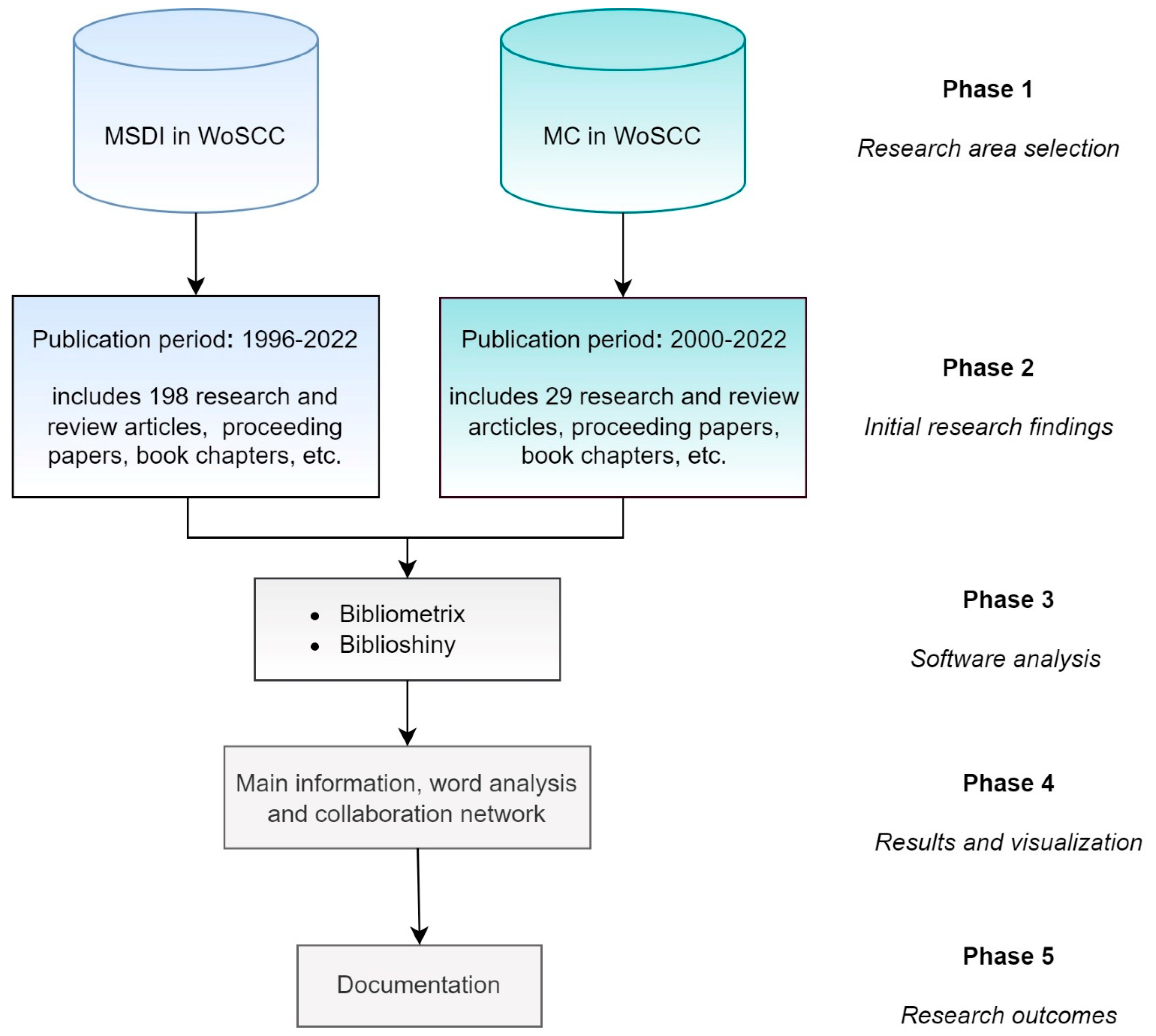
Bibliometric research is divided into the following phases (Figure 1): (1) research area selection; (2) initial research findings; (3) software analysis; (4) results and visualization; and (5) research outcomes.
The research was carried out in two directions: review and analysis of the literature related to MC and of the literature related to MSDI. In addition to their independent analyses, the important answers that emerged served as a good basis with a list of their mutual connections.
2.1. Phase 1—Research Area Selection
As explained in detail in Section 1.1, the focus of the research lies in the analysis of the connection of MSP with BE and BG and the connection of its technical topics MC and MSDI. Given that the goal is to observe the representation of topics in technical sciences, the research is based on the 6 research questions presented in Section 1.1. In addition to the separate research of MC and MSDI, it is very important to examine their mutual connection. One of the basic research questions that arise is how interesting MC is as a scientific research topic within MSDI and in what way and to what extent are MC and MSDI recognized within the development and establishment of SMEs. Equally, it is very important to examine the global representation of these topics as well as cooperation between countries where scientific activity for the mentioned topics has been recorded. All the obtained data give the basis for conclusions about the current situation but also new knowledge to plan future activities. As it was emphasized, science is the basis of every practical development, and the analysis of the current situation gives information on how fast this development will move in the future. In times of increasing environmental awareness of the nature that surrounds us, it is extremely important to precisely plan how man and his interests can fit into the natural cycle and ensure that his actions leave no long-term consequences. These topics are extremely important, primarily from the perspective of planning and controlling human activities at sea. The goal of MSP is to ensure that human activities are carried out in an efficient, safe and sustainable manner, and MC and MSDI are extremely important in supporting these processes. Precisely based on all the above, a bibliometric analysis of the titles related to the mentioned topics will be presented below through a visual representation and textual explanation. The analysis was performed based on bibliometric titles found in the WoSCC database.
2.2. Phase 2—Initial Research Findings
MSDI and MC topics were analysed separately with the selection of the “Topic” field and without a time limit for data analysis. The reason for not setting a certain time limit, or taking into account only recent titles, is, on the one hand, the fairly limited number of papers and, on the other hand, monitoring the growth of the scientific community’s interest in the mentioned topics over time.
An initial insight into the basic statistical data was already obtained during the initial search in the WoSCC database. Namely, for the subject of MSDI, 198 titles were found, most of which (152 titles) were classified as original scientific articles. The rest of them belong mostly to proceedings papers, then review articles and book chapters. The time period that covered the analysed titles is from 1996 until the middle of this year, 2022, since no paper on the MDSI topic was published in WoSCC data base previously to 1996. More than a quarter of all published works were by authors from the USA (52 titles), while the rest of the most represented came from Italy (27 titles), UK (26 titles), Spain (18 titles), Australia (16 titles), etc.
Equally, most of the papers are open access, which also provides an easier insight into the literature to the wider scientific and non-scientific community. Publishers such as Elsevier (43 titles), Springer Nature (24 titles), IEEE (15 titles), Taylor & Francis (15 titles) and MDPI (14 titles) confirm the quality of published papers. According to the information from the WoSCC categorization of papers, the conclusion is that, overall, the interest of the social sciences, in the mentioned topics, is ahead of the technical sciences, but one can also notice the growing number of papers of the technical profession a few years back. The technical contribution to the mentioned areas is very important. It can be undoubtedly stated that it is growing. In addition to the analysis of basic social issues and valuable guidelines for future development, technical solutions are extremely important if the above is to be intensively implemented in practice.
On the other hand, a separate analysis of MC yielded a rather small number of titles, only 29, most of which (22 titles) were classified as original scientific articles. The rest belong to proceedings papers, book chapters and review articles. The time period that covered the analysed titles is from 2000 until the middle of this year, 2022, since no paper on the MC topic was published in the WoSCC data base prior to 2000. The authors who dealt with the mentioned topic are properly distributed and mostly from Turkey, USA, Australia, Greece and Poland. Publishers such as IEEE (4 titles), Elsevier (3 titles), MDPI (3 titles) and Springer Nature (2 titles) also confirm that, although the total number of papers is quite small, they nevertheless met the highest quality requirements. In contrast to the papers dealing with the MDPI topic, as far as the scientific fields of the papers are concerned, they are equally distributed between social and technical sciences.
This is a very good background and incentive for technicians to intensify their research on this topic. The MC is a significant and contemporary topic that needs to be more recognizable in the future. The initial study of the literature gave insight into the frequency of terms related to the sea, specifically planning at sea. According to the survey conducted by the CVP [29], many stakeholders directly connect and even identify the terms Marine Spatial Planning and Marine Cadastre. The term MSP is far more prevalent in scientific literature than the term Marine Cadastre and even the term MSDI. The reason for this is that it is a comprehensive concept that, in addition to planning activities at sea, i.e., synergy between human activities at sea on the one hand and protection of the marine environment on the other, regulates different roles and responsibilities in the use of marine surroundings. MSP is a process that monitors and controls human activity at sea, while MC is a system that primarily provides information about the restrictions, rights and responsibilities of stakeholders as users of that space [29]. It can be said that the establishment of the MC can be considered as a fundamental component in the establishment of MSP. Without detailed knowledge of the three Rs, it is not possible to plan or control human activities at sea. It was this conclusion that gave the authors of this paper an incentive for a detailed presentation of the topic related to the MC and, in the context of this paper, the current state of professional and scientific literature on the mentioned topic.
2.3. Phase 3—Software Analysis
Bibliometrics belongs to the statistical methods used to analyse various data related to scientific books, articles and other publications. Bibliometric analysis is based on statistics and mathematics, and by analysing the current state of the scientific field, it provides guidelines for future research work. The analysis is based on three indicators: quantitative, indicating the level of productivity of researchers in a particular field; qualitative, indicating productivity within the entire research area, which is expressed on the basis of the total number of citations; and structural, indicating the connection between authors, research areas, publications and countries. There are many applications or software that can perform bibliometric analysis, and in this research, the retrieved data were analysed for bibliometric indicators using Rstudio v.4.1.2 software with Bibliometrix R-package. The retrieved data were analysed for bibliometric indicators using Rstudio v.4.1.2 software with Bibliometrix R-package [87]. Its web-based application, Biblioshiny, was used for final analysis and data visualization. Biblioshiny combines the functionality of Bibliometrix package with the easy use of web-apps using the Shiny package environment [88]. Initial research was conducted both with VOSviewer and Bibilometrix, and it was estimated that more targeted answers to the questions that were originally asked could be obtained through Bibilometrix.
2.4. Phase 4—Results and Visualization
Below is a visual analysis of the terms “marine cadastre” and “marine spatial data infrastructure” obtained in the Bibliometrix software package. The basic statistical data related to the both terms are processed in detail in Phase 2.
2.4.1. MSDI—Results and Visualization
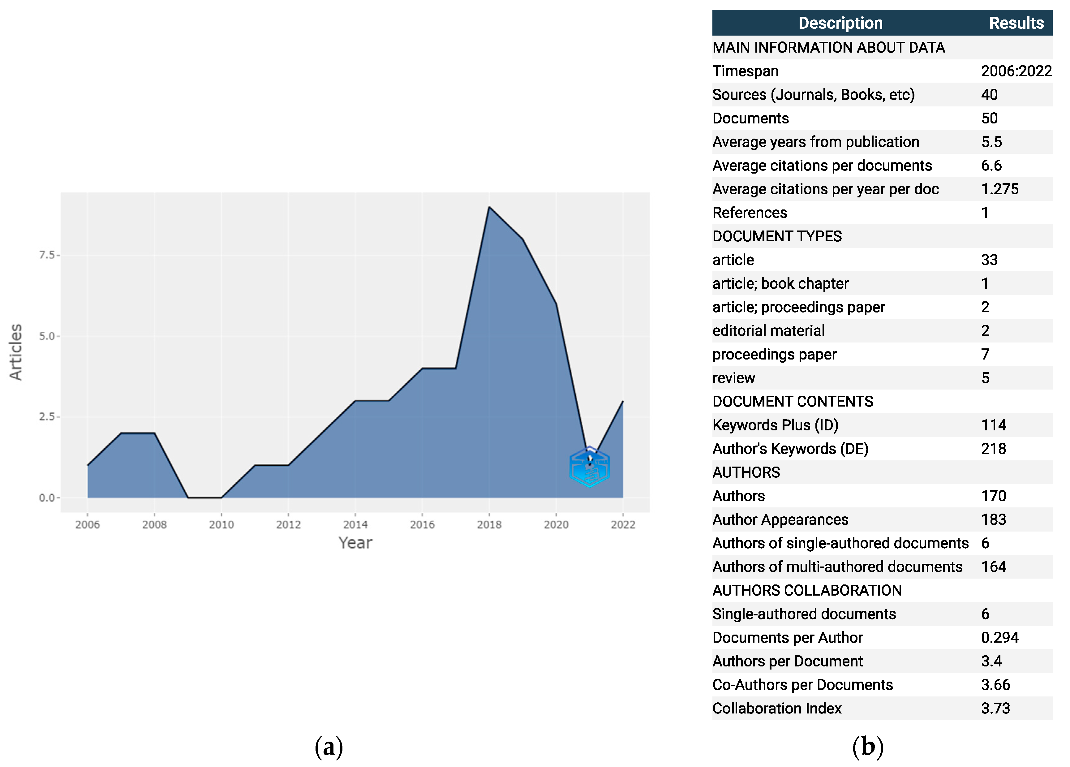
Figure 2 gives an insight into the annual scientific production for the term “marine spatial data infrastructure”, which shows the significant annual growth of the scientific community’s interest in the mentioned term. Data interpretation served as an answer to the first research question. The average number of citations per document is 6.6, that is, 1.28 citations per document per year. There are only 6 single-authored documents, while the average number of co-authors per document is 3.66. The Collaboration Index (CI) is a number that defines the ratio of the total number of authors on an article to the total number of articles with multiple authors [89]. In other words, the CI is an index that is calculated only for articles with more than one author. In this analysis, the CI is calculated, and it is 3.73.
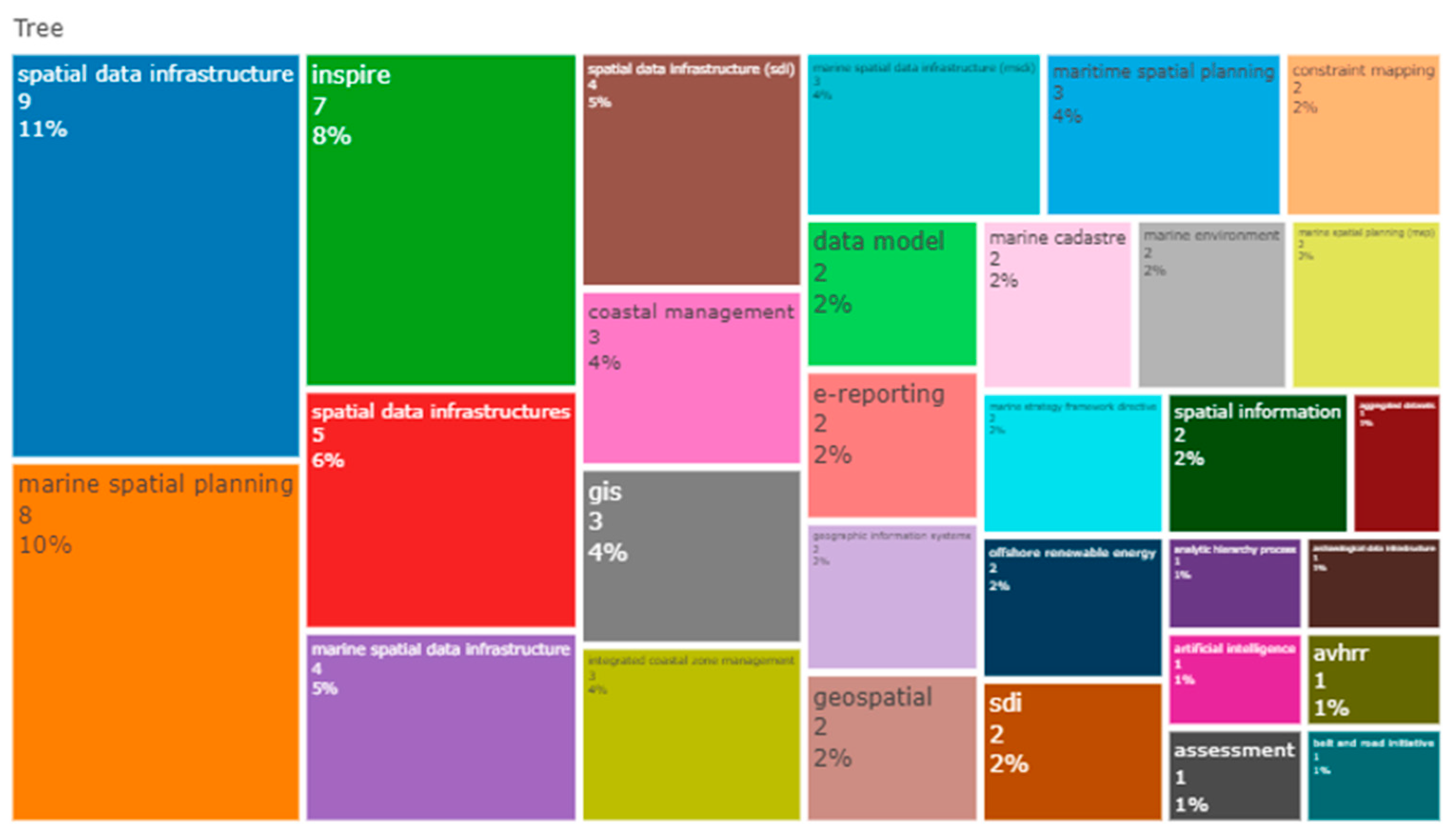
Figure 3 shows the percentage representation of individual keywords in the total number of all author keywords related to the subject of MSDI. Namely, in addition to the expected keywords such as “marine spatial data infrastructure”, “spatial data infrastructure”, “marine spatial planning” and “INSPIRE directive”, which refer to spatial data and support the creation of policies related to the environment, are also highlighted and important. Likewise, “GIS”, “data model”, “coastal management” and “integrated coastal zone management” are those that refer to models and systems that include data analysis procedures and the establishment of marine area management processes. The description of the figure provides an answer to the second research question. The representation of the MC topic within scientific research related to MSDI is rather small. Only 2 percent of keywords are related to the term MC. Analysing the connection of other terms with MSDI, it can be concluded that the majority of scientific papers are related to the organization of existing data, as well as proposals for the development of integrated systems within which MSDI serves as a component of data organization and to make final decisions. The above is especially important when establishing a comprehensive system, which would include MSP, MC and the adoption of regulations, all based on quality collected, processed and distributed data. Until now, decision making has been limited to decision making by a group of stakeholders, most often from government structures who are often not deeply familiar with the topic. This kind of system, which would include various stakeholders as users of the mentioned space to make joint decisions for the benefit of the wider community, would improve the processes of planning and management of the marine surrounding.
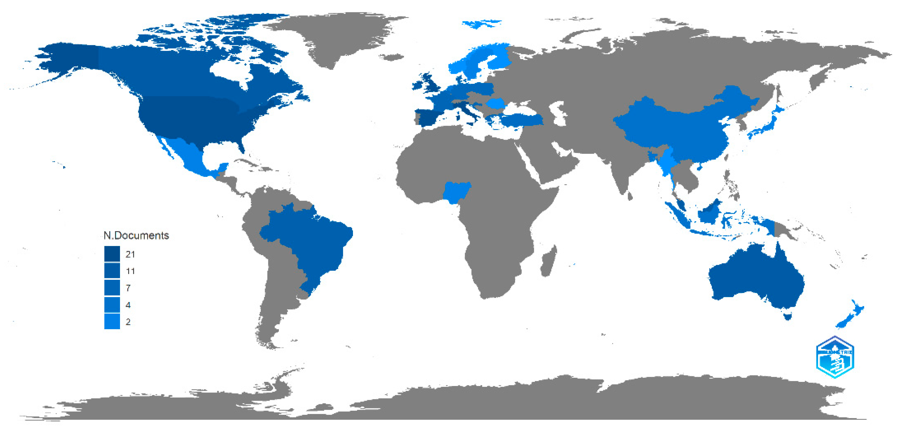
Figure 4 shows the scientific production of individual countries in the world and provides an answer to the fourth research question. It can be seen how the research results are spatially distributed. Productivity rates are shown in a range from dark blue, which indicates extremely high scientific productivity for the given topic, to grey, which is used for countries where no scientific productivity has been recorded for the given topic. The majority of the scientific outputs were developed in USA, Australia, Spain, UK, Malaysia and Italy. A basic visual inspection can conclude that MSDI is recognised in North America, Australia and Europe, but rarely in Asia, Africa and South America. To obtain precise answers, a detailed analysis of the issue should certainly be carried out, from the legislation of an individual state, strategies and goals of the state and also of the international community, but certainly, the degree of development of an individual state has one of the key roles in this. Developed countries should provide scientific and practical assistance to the less developed countries of the world in the sharing of knowledge and experience but certainly also in financial assistance when establishing a sustainable system of planning and control of all human activities at sea.
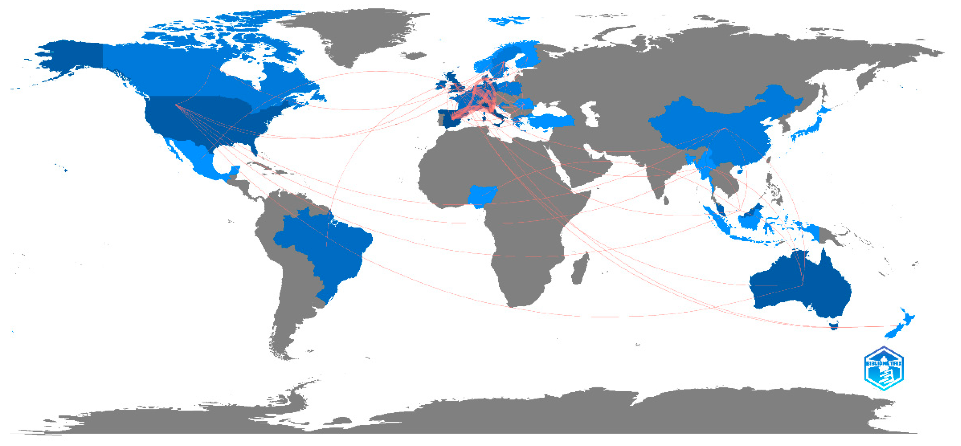
Figure 5 shows the level of collaboration of each active country with other active countries and provides an answer to the fifth research question. The level of activity is graded with colours that range from dark blue, which indicates a country with an extremely high rate of collaboration, to grey, which indicates countries that do not collaborate with other countries. Countries that actively collaborate with other countries are the USA, UK, Italy, Spain, Malaysia and Australia. Those are precisely the countries that publish the most papers related to the topic of “marine spatial data infrastructure”. The map also shows that the USA is the country that cooperates the most, and that cooperation between countries at the European level is extremely strong. The countries of Africa, Asia and South America show little or no cooperation, and countries dealing with the mentioned topic cooperate with some of the other active countries in Europe, North America and Australia. The above was to be expected based on the analysis of the scientific productivity of individual countries, but it must be emphasized that the exchange of scientific and professional experiences of even a small number of countries in an almost inactive area gives hope that they will be promoters for other countries in the region. The exchange of common experiences creates the possibility of defining general guidelines that could be adopted and modified by countries that currently do not show greater scientific activity in the observed issue.
2.4.2. MC—Results and Visualization
Figure 6 gives an insight into the annual scientific production for the term “marine cadastre” and provides an answer to the first research question. The average number of citations per document is 5.11, that is, 0.52 citations per document per year. There are six single-authored documents, while the average number of co-authors per document is 2.7. The CI scored a value of 3.09.
Figure 7 depicts a word cloud of MC keywords and provides an answer to the third research question. The most common keywords are centred and highlighted in the image such as “marine cadastre”, “GIS”, “3D cadastre”, “geovisual analytics”, “SDI”, “marine area”, “LADM”, etc. SDI, as a broader term for MSDI, certainly refers to data about the sea, and from the above, it can be concluded that there is a strong enough connection between the terms MC and MSDI. The other terms are mainly focused on the organization, analysis and visualization of the data related to the sea. Equally, terms that include the word “system” in their name are very important because they refer to scientific research that deals with the development of methodology for supporting the final decisions.
Figure 8 depicts the country’s scientific production map related to the term “marine cadastre” and provides an answer to the fourth research question. Countries that write on the topic are the USA, Brazil, Poland, Turkey, Australia and Russia. It can be concluded that although the terms “marine cadastre” and “marine spatial data infrastructure” are thematically closely related, apart from the USA and Australia the countries dealing with the mentioned terms are quite different. In general, the recognition of MC in the scientific literature is rather weak (only 29 papers were found), but the information that it is very low in Europe was certainly surprising. North America and Australia are in a much better situation than Europe. In contrast to the analysis of the term MSDI, MC is globally more recognized in South America and Asia. Future directions of scientific research should certainly proceed to better clarification of each concept separately and emphasizing their extremely important connection incorporated into a system based on the spatial planning process at sea.
2.5. Phase 5—Research Outcomes
Based on the research conducted several things can be concluded. Some progress on the growth of MC and MSDI research was made in the last decade or so, but there is a huge space for further improvement. The answer to Q1 (Is there a scientific growth of MC and MSDI topics in WoSCC database and is their growth good enough in context of ambitious plans on BE?) is that it is going in the direction of a growth, but numbers are very poor, especially on the topic of MC, and the growth is not visible in the last two or three years for both categories. In technical and engineering domains, MC and MSDI need much more research in the theoretical and practical domains. They are one of the foundations for MSP, BE and BG development in the context of sustainable development and should not be neglected. The answer to Q1 is an obvious reason why MC and MSDI or terms from the engineering and technical domains are not visible in MSP research by Chalastani et al. [18]. Q2 (How recognizable is the MC in the field of MSDI as a basic layer of MSDI?) and Q3 (How recognizable is the MSDI in the MC scientific research?) could be observed as one question, but the research had to be treated separately. As the outcome of the research of the word tree map and the word cloud, it can be stated that MC and MSDI were key words in papers that had a strong enough connection. Answering Q4 (Which parts of the world are scientifically active on the topic of MC and MSDI to be able to learn from their knowledge and experience?), the situation is again not good. MSDI is recognised in North America, Australia and Europe, but rarely in Asia, Africa and South America. MC recognition is very poor, too, but it was not expected to be that low in Europe. North America and Australia are in a much better situation. As the answer to Q5 (Is there a collaboration between countries?) it can be stated that in the area of MSDI there is a certain collaboration between countries and continents. A good example is collaboration inside Europe. The other continents should pursue collaboration more than they do now. Undeveloped MC, even in the sense of collaboration in science (the results were so low that there was no point in showing them graphically in the paper), does not have a good outcome in the sustainable development world. After the first five answers to questions, the future does not look promising. The answer to Q6 (What are the future expectations?), yet cannot be negative. The positive outcomes are that there are some parts of the world giving the topic of technology and engineering of marine and maritime domain, in the context of sustainable development, proper attention. One can always learn from their experience and stronger cooperation can and should be established. Europe can improve on the same basis. As stated in first chapter, there are many projects underway on marine topics. Maybe stronger outcomes should be expected in sense of scientifically stronger recognised outcomes, with emphasis on the technical and engineer’s professions.
3. Discussion and Conclusions
On the presented scientific research basis, both MC and MSDI are stagnant in the last two to three years in the scientific community. The number of papers published is low. On the other hand, MSP is developing strongly according to Chalastani et al. [18]. The numbers resulting by the research are not favourable for the MC and MSDI scientific fields. The consequences will be seen in the long-run in MSP and BE. Today, the necessity of national SDIs establishment is not questioned and developed states are investing in them on daily basis. The necessity of Land Cadastre is not questioned as well. At some point, coastal countries will have to be aware that for them, the sea and coast are an important part of their territory, especially in the context of strong BE development. There are many challenges in the area of MC establishment, a continuation of Land Cadastre parcels to maritime goods in the coastal parts and their continuation on the territorial sea. The extreme problems are also jurisdictions. There are so many different developments going on at sea, ecological, archaeological, biological, oceanographical, historical and concessional, and there is also oil extraction, tourism, fishing, shellfish and fish farming, transport, different pipe installations for electricity, gas, telecommunication, etc. Usually, the jurisdiction is with the one who owns the data, but in this process, establishing a data base on a national level would be a possible solution. Spatial planning on land and on sea is of equal importance and should be treated as such. The good thing is that MSP is advancing, but it should be followed by MSDI and MC with a more progressive approach than it is determined in this research.
As could be seen in the Sweden example, private sea parcels exist today. It will be needed to define three Rs on those parcels. Other coastal countries will inevitably follow the example, sooner or later. Most of them nowadays have sea concessions and it is just one step away from the private sea parcel. MC establishing should start by standardisation and theoretical clarifications and learning about other countries’ experience. Some positive examples could be seen in literature review of this paper together with the conclusion that MSDI and MC are of huge importance in coastal, sea and ocean management.
The limitation of this research is the fact that the topic is not exclusively in charge of the scientific community, so the picture is broader. On the other hand, it cannot be denied that scientific research is important in technical and technological development in practice and undoubtedly in theory and knowledge transfer. There are some research groups inside IHO, OGC Marine Domain Working Group [90] and, for instance, University Consortium for GIS [73] dealing with the topic of MSDI and MSP, and there was a CVP group researching the MC. The large number of data are in charge of hydrographic offices, but they do not have all the necessary data for MC and MSDI and MSP establishment. EU has an ambitious, sustainable program on BE. Yet, European scientific community does not recognise the need for theoretical definitions and standardisations of MC and MSDI, nor their establishment in practice. There are some improvements in EU Directives, but it is not enough. As stated in the first part of the paper, there are many projects in Europe on marine and maritime domains. Maybe it is time for their stronger outcomes, for stronger promotion, educational programs and capacity building in the field and stronger communication on marine and maritime topics between developed and less developed coastal and other countries.
Wider research could be conducted including participants outside the scientific community, resulting in establishing possible groups of spatial data at sea, coasts and oceans. Further research could be conducted on rivers and lakes and their spatial planning and cadastral recording state. There is a possibility of water parcel management in those parts in the future, too. Special attention should be given to the 4D sea parcel, with so many different possibilities opening up in a matter of concessions and private parcels dealing.
Scientists should be the leaders of society and the carriers of progress. It is of utmost importance to increase the education and capacity building in the marine and maritime domain in technical and engineering professions. That will produce specialists who will be able to deal with problems that occur in practice. Standardisation should be also improved and jurisdiction defining could give a booster to the field.
Author Contributions
Conceptualization, I.R. and J.K.P.; methodology, I.R. and J.K.P.; software, J.K.P. and I.R.; validation, I.R., M.Z. and J.K.P.; formal analysis, J.K.P.; investigation, I.R. and J.K.P.; resources, I.R. and J.K.P.; data curation, J.K.P.; writing—original draft preparation, I.R. and J.K.P. and M.Z.; writing—review and editing, I.R., M.Z. and J.K.P.; visualization, J.K.P.; supervision, I.R. and M.Z. All authors have read and agreed to the published version of the manuscript.
Funding
This research received no external funding.
Data Availability Statement
Not applicable.
Acknowledgments
This research is partially supported through project KK.01.1.1.02.0027, a project co-financed by the Croatian Government and the European Union through the European Regional Development Fund—the Competitiveness and Cohesion Operational Programme.
Conflicts of Interest
The authors declare no conflict of interest.
References
- European Commission. EUROPE 2020—A Strategy for Smart, Sustainable and Inclusive Growth. 2010. Available online: https://ec.europa.eu/eu2020/pdf/COMPLET%20EN%20BARROSO%20%20%20007%20-%20Europe%202020%20-%20EN%20version.pdf (accessed on 12 August 2022).
- European Commission. Blue Growth. 2021. Available online: https://s3platform.jrc.ec.europa.eu/blue-growth (accessed on 12 August 2022).
- Interreg Europe. From Blue Growth to Sustainable Blue Economy: A New Approach for the EU. 2021. Available online: https://www.interregeurope.eu/news-and-events/news/from-blue-growth-to-sustainable-blue-economy-a-new-approach-for-the-eu (accessed on 13 August 2022).
- European Bank Investment Group. Clean Oceans and the Blue Economy, Overview. 2022. Available online: https://www.eib.org/attachments/publications/clean_oceans_and_the_blue_economy_overview_2022_en.pdf (accessed on 14 August 2022).
- Blue Action. Available online: https://blue-action.eu/policy-feed/blue-growth (accessed on 12 August 2022).
- Racetin, I.; Ivić, M.; Kilić, J. Blue geoinformation. In Proceedings of the 18th International Multydisciplinary Scientific Geoconference SGEM 2018, Albena, Bulgaria, 2–8 July 2018; STEF92 Technology Ltd.: Sofia, Bugarska, 2018; pp. 227–233. [Google Scholar] [CrossRef]
- European Commission. European Green Deal: Developing a Sustainable Blue Economy in the European Union. 2021. Available online: https://ec.europa.eu/commission/presscorner/detail/en/ip_21_2341 (accessed on 14 August 2022).
- European Union. Putting the Blue into the Green, Sustainable Blue Economy. 2021. Available online: https://oceans-and-fisheries.ec.europa.eu/ocean/blue-economy/sustainable-blue-economy_en (accessed on 12 August 2022).
- World Bank Group, Open Knowledge. Available online: https://openknowledge.worldbank.org/ (accessed on 14 August 2022).
- United Nations. Blue Economy Definitions. 2021. Available online: https://www.un.org/regularprocess/sites/www.un.org.regularprocess/files/rok_part_2.pdf (accessed on 12 August 2022).
- European Commission. What Is the Blue Economy? 2018. Available online: https://blueindicators.ec.europa.eu/access-online-dashboard (accessed on 13 August 2022).
- The Commonwealth. Sustainable Blue Economy. 2021. Available online: https://thecommonwealth.org/bluecharter/sustainable-blue-economy (accessed on 12 August 2022).
- Middlebury Institute of International Studies. Center for the Blue Economy. 2021. Available online: https://www.middlebury.edu/institute/academics/centers-initiatives/center-blue-economy (accessed on 13 August 2022).
- United Nations. Exploring the Potential of the Blue Economy. 2022. Available online: https://www.un.org/en/desa/exploring-potential-blue-economy (accessed on 15 August 2022).
- European Commission. What Is Smart Specialisation? Available online: https://s3platform.jrc.ec.europa.eu/what-we-do (accessed on 13 August 2022).
- European Commission. The EU Blue Economy Report; Publications Office of the European Union: Luxembourg, 2022. Available online: https://www.robert-schuman.eu/en/doc/actualites/KLAR22001ENN.pdf (accessed on 15 August 2022).
- Arvanitis, A.; Giannakopoulou, S.; Parri, I. Marine Cadastre to Support Marine Spatial Planning. In Proceedings of the Common Vision Conference: Migration to a Smart World; EULIS: Amsterdam, The Netherlands, 2016; pp. 1–74. [Google Scholar]
- Chalastani, V.I.; Tsoukala, V.K.; Coccossis, H.; Duarte, C.M. A bibliometric assessment of progress in marine spatial planning. Mar. Policy 2021, 127, 104329. [Google Scholar] [CrossRef]
- Frazao Santos, C.; Ehler, C.N.; Agardy, T.; Andrade, F.; Orbach, M.K.; Crowder, L.B. Marine Spatial Planning (Chapter 30). In World Seas: An Environmental Evaluation, 2nd ed.; Sheppard, C., Ed.; Academic Press: Cambridge, MA, USA, 2019; pp. 571–592. [Google Scholar]
- Ehler, C.N. Marine Spatial Planning: An Idea Whose Time Has Come, Offshore Energy and Marine Spatial Planning; Taylor and Francis: London, UK, 2017; pp. 6–17. [Google Scholar] [CrossRef]
- Ehler, C.; Zaucha, J.; Gee, K. Maritime/Marine Spatial Planning at the Interface of Research and Practice. In Maritime Spatial Planning: Past, Present, Future; Zaucha, J., Gee, K., Eds.; Springer International Publishing: Cham, Switzerland, 2019; pp. 1–21. [Google Scholar]
- European Commission. Blue Growth. 2021. Available online: https://ec.europa.eu/inea/en/horizon-2020/blue-growth (accessed on 15 August 2022).
- Interreg Europe. Available online: https://projects2014-2020.interregeurope.eu/ (accessed on 15 August 2022).
- Blue WBC. Available online: https://bluewbc.eu/?fbclid=IwAR2WOft_iaBaRfulXkY_MH52gpv0RuD4e-bv_yzLDRrs3R4Xq8_kiU7UAZA (accessed on 15 August 2022).
- Mates. Available online: https://www.projectmates.eu/ (accessed on 15 August 2022).
- MaQuaM. Available online: https://strategis-cluster.net/activities/maquam-project/ (accessed on 15 August 2022).
- The European Atlas of the Seas. Available online: www.european-atlas-of-the-seas.eu (accessed on 14 August 2022).
- Guay, C. Marine Spatial Data Infrastructure for Marine Spatial Planning. Canadian Hydrographic Service. 2019. Available online: https://ggim.un.org/meetings/GGIM-committee/9th-Session/side_events/Monday/Marine/4-Claude-Guay.pdf (accessed on 15 August 2022).
- Marine Cadastre in Europe—A Preliminary Study. Available online: https://www.clge.eu/wp-content/uploads/2016/12/Marine_Cadastre_in_Europe_Brief_Edition_V-1.01_2017.pdf (accessed on 11 February 2022).
- Balla, E.; Wouters, R. Marine Cadastre in Europe: State of play (NR 355). In Proceedings of the 2017 World Bank Conference on Land and Poverty, Washington, DC, USA, 20–24 March 2017; The World Bank: Washington, DC, USA, 2017; pp. 1–26. [Google Scholar]
- Tares, T. Marine Spatial Data Infrastructures. Master’s Thesis, University College London, London, UK, 2013. [Google Scholar]
- Metadata: Australian Maritime Boundaries Information System (AMBIS). Available online: http://www.ntlis.nt.gov.au/metadata/export_data?metadata_id=2DBCB7711FAE06B6E040CD9B0F274EFE&type=html (accessed on 13 August 2022).
- Australian Marine Spatial Information System. Available online: https://www.ga.gov.au/scientific-topics/marine/jurisdiction/amsis (accessed on 13 August 2022).
- Guay, C. Canada’s Marine Spatial Data Infrastructure. Presentation to the International Hydrographic Organization’s Marine Spatial Data Infrastructure Working Group. 2021. Available online: https://iho.int/uploads/user/Inter-Regional%20Coordination/MSDIWG/MSDIWG12on/MSDIWG12on-04B_Canada%20National%20Report.pdf (accessed on 15 August 2022).
- Office for Coastal Management. Available online: www.coast.noaa.gov (accessed on 15 August 2022).
- Marine Cadastre.gov. Available online: https://marinecadastre.gov (accessed on 15 August 2022).
- Data.gov. Available online: https://data.gov/ocean/ (accessed on 15 August 2022).
- Muto, M.; Tsunoda, T.; Kumasaka, F. Development of Marine Spatial Data Infrastructure in Japan. In Proceedings of the GSDI 2012 Conference, Quebec City, QC, Canada, 14–17 May 2012; Mitsubishi Research Institute, Inc. & Japan Hydrographic Association: Osaka, Japan, 2012. [Google Scholar]
- Griffin, E.; Coote, A.; Crompvoets, J. A marine spatial data infrastructure in New Zealand: A systematic review on the cost-benefits. J. Spat. Sci. 2017, 64, 33–47. [Google Scholar] [CrossRef]
- Srebro, H. Implementation of Marine Cadastre in Israel. In Proceedings of the FIG Working Week 2015, Sofia, Bulgaria, 17–21 May 2015. [Google Scholar]
- Canadian Hydrographic Service (CHS). A Comparative Study of the Development of Marine Spatial Data Infrastructure (MSDI) by IHO Member Nations. 2016. Available online: https://www.iho.int/mtg_docs/com_wg/MSDIWG/MSDIWG7/MSDIWG7-1.8A-MSDI_Comparative_Study.docx (accessed on 14 August 2022).
- Le Shom. Available online: www.shom.fr (accessed on 14 August 2022).
- Melles, J. The German Marine Data Infrastructures and EU Directives. In Proceedings of the INSPIRE Conference 2015, Lisbon, Portugal, 20–24 April 2015. [Google Scholar]
- MDI.DE Geoportal. Available online: https://www.mdi-de.org (accessed on 15 August 2022).
- GeoSeaPortal. Available online: https://www.geoseaportal.de (accessed on 15 August 2022).
- Contarinis, S.; Pallikaris, A.; Nakos, B. The Value of Marine Spatial Open Data Infrastructures—Potentials of IHO S-100 Standard to Become the Universal Marine Data Model. J. Mar. Sci. Eng. 2020, 8, 564. [Google Scholar] [CrossRef]
- Abramic, A.; Bigagli, E.; Barale, V.; Assouline, M.; Lorenzo-Alonso, A.; Norton, C. Maritime spatial planning supported by infrastructure for spatial information in Europe (INSPIRE). Ocean. Coast. Manag. 2018, 152, 23–36. [Google Scholar] [CrossRef] [Green Version]
- Hansen, H.S.; Reiter, I.N.; Schrøder, L.A. System Architecture for a Transnational Data Infrastructure Supporting Maritime Spatial Planning; Kő, A., Francesconi, E., Eds.; EGOVIS 2017, LNCS 10441; Springer International Publishing: Cham, Switzerland, 2017; pp. 158–172. [Google Scholar]
- Navas, F.; Guisado-Pintado, E.; Malvárez, G. Interoperability as supporting tool for Future Forecasting on coastal and marine areas. J. Coast. Res. 2016, 75, 957–961. [Google Scholar] [CrossRef]
- Blue World Institute. Available online: https://www.plavi-svijet.org/zastita/morska-zasticena-podrucja-i-prostorno-planiranje-na-moru/ (accessed on 1 June 2022).
- European Parliament and Council (EPC). Directive 2014/89/EU of the European Parliament and of the Council. Available online: http://eur-lex.europa.eu/legal-content/EN/TXT/?uri=celex%3A32014L0089 (accessed on 1 June 2022).
- Ehler, C.; Douvere, F. Marine Spatial Planning: A Step-by-Step Approach; (IOC Manuals and Guides 53), (ICAM Dossier 6); Unesco: Paris, France, 2009; p. 99. [Google Scholar] [CrossRef]
- Douvere, F. The importance of marine spatial planning in advancing ecosystem-based sea use management. Mar. Policy 2008, 32, 762–771. [Google Scholar] [CrossRef]
- Remmpis, N.; Tsilimigkas, G. Marine spatial planning on Crete Island, Greece: Methodological and implementation issues. J. Spat. Sci. 2021. [Google Scholar] [CrossRef]
- Kyriazi, Z. From identification of compatibilities and conflicts to reaching marine spatial allocation agreements. Review of actions required and relevant tools and processes. Ocean. Coast. Manag. 2018, 166, 103–112. [Google Scholar] [CrossRef]
- Rempis, N.; Alexandrakis, G.; Tsilimigkas, G.; Kampanis, N. Coastal use synergies and conflicts evaluation in the framework of spatial, development and sectoral policies. J. Ocean. Coast. Manag. 2018, 166, 40–51. [Google Scholar] [CrossRef]
- Depellegrin, D.; Menegon, S.; Farella, G.; Ghezzo, M.; Gissi, E.; Sarretta, A.; Venier, C.; Barbanti, A. Multi-objective spatial tools to inform maritime spatial planning in the Adriatic Sea. Sci. Total Environ. 2017, 609, 1627–1639. [Google Scholar] [CrossRef] [Green Version]
- Zekić, A.; Luttenberger, A. Contribution of Marine Spatial Planning to the Protection of Marine Environment. J. Marit. Transp. Sci. Vol. 2016, 283–296. [Google Scholar] [CrossRef]
- Jajac, N.; Kilić, J.; Rogulj, K. An Integral Approach to Sustainable Decision-Making within Maritime Spatial Planning—A DSC for the Planning of Anchorages on the Island of Šolta, Croatia. Sustainability 2018, 11, 104. [Google Scholar] [CrossRef] [Green Version]
- Widodo, M.S.; Leach, J.; Williamson, I. Marine Cadastre and Spatial Data Infrastructures in Marine Environment. In Proceedings of the Joint AURISA and Institution of Surveyors Conference Adelaide, Adelaide, Australia, 25–30 November 2002; pp. 1–14. [Google Scholar]
- Fadaie, K.; Guay, C. Canada’s Marine Spatial Data Infrastructure, Canadian Hydrographic Conference. 2016. Available online: https://hydrography.ca/wp-content/uploads/2020/04/2016-CHC-MSDI-Presentation-Claude-Guay.pdf (accessed on 16 August 2022).
- Robertson, B.; Benwell, G.; Hoogsteden, C. The Marine Resource: Administration Infrastructure Requirements. UN-FIG Conference on Land Tenure and Cadastral Infrastructures for Sustainable Development, Melbourne, Australia. 1999. Available online: http://citeseerx.ist.psu.edu/viewdoc/download?doi=10.1.1.40.3066&rep=rep1&type=pdf (accessed on 29 June 2022).
- Nichols, S.; Monahan, D.; Sutherland, M. Good Governance of Canada’s Offshore and Coastal zone: Towards an Understanding of the Marine Boundary Issues. Geomatica 2000, 54, 415–424. [Google Scholar] [CrossRef]
- Zentelis, P. Talking about land and Cadastre. Papasotiriou Editions; Athens, Greece. 2011. (In Greek) [Google Scholar]
- Sutherland, M. Report on the Outcomes of the UNB-FIG Meeting on Marine Cadastre Issues; The Wu Centre, University of New Brunswick: Fredericton, NB, Canada, 2003. [Google Scholar]
- Binns, A.; Rajabifard, A.; Collier, P.A.; Williamson, I. Issues in Defining the Concept of a Marine Cadastre for Australia. In Proceedings of the UNB-FIG Meeting on Marine Cadastre Issues; Fredericton, NB, Canada, 15–16 September 2003, 2003; pp. 1–14. [Google Scholar]
- Athanasiou, K.; Sutherland, M.; Kastrisios, C.; Tsoulos, L.; Griffith-Charles, C.; Davis, D.; Dimopoulou, E. Toward the Development of a Marine Administration System Based on International Standards. ISPRS Int. J. Geo-Inf. 2017, 6, 194. [Google Scholar] [CrossRef] [Green Version]
- Rajabifard, A.; Binns, A.; Williamson, I.P. Marine Administration and Research Activities within Asia and the Pacific Region-Towards a Seamless Land-Sea Interface; Administering Marine Spaces: International Issues; FIG Publication: Copenhagen, Denmark, 2006; Volume 36, pp. 21–35. [Google Scholar]
- Strain, L.; Binns, A.; Rajabifard, A.; Williamson, I.P. Spatially administering the marine environment. In Proceedings of the SSC 2005 Spatial Intelligence, Innovation and Praxis: The National Biennial Conference of the Spatial Sciences Institute, Melbourne, Australia, 12–16 September 2005; Spatial Sciences Institute: Melbourne, Australia, 2005; pp. 1–12. [Google Scholar]
- Fadaie, K. A Comparative Study of the Development of Marine Spatial Data Infrastructure (MSDI) by IHO Member Nations; 2016, ppt presentation, pp. 1–64.
- International Hydrographic Organization (IHO). Spatial Data Infrastructures: “The Marine Dimension”. Guidance for Hydrographic Offices. Published by International Hydrographic Bureau, Monaco. 2011. Available online: https://www.iho.int/iho_pubs/CB/C-17_e1.1.0_2011_EN.pdf (accessed on 28 June 2022).
- International Hydrographic Organization (IHO). The Hydrographic and Oceanographic Dimension to Marine Spatial Data Infrastructure Development: “Developing the capability”, White Paper, International Hydrographic Organization. 2010. Available online: http://www.iho.int/mtg_docs/com_wg/MSDIWG/MSDIWG_Misc/Marine_SDI_Documents/MSDI_white_paper.pdf (accessed on 28 June 2022).
- University Consortium for GIS. DM-91-Marine Spatial Data Infrastructure. Available online: https://gistbok.ucgis.org/bok-topics/marine-spatial-data-infrastructure (accessed on 20 September 2022).
- De Latte, G. Marine Cadastre—Legal Framework UNCLOS & EU legislation. In Proceedings of the Common Vision Conference 2016 Migration to a Smart World, EULIS, Amsterdam, The Netherlands, 5–7 June 2016. [Google Scholar]
- Gavel, Y.; Iselid, L. Web of Science and Scopus: A journal title overlap study. Online Inf. Rev. 2018, 32, 8–21. [Google Scholar] [CrossRef]
- Mongeon, P.; Paul-Hus, A. The Journal Coverage of Web of Science and Scopus: A Comparative Analysis. Scientometrics 2016, 106, 213–228. [Google Scholar] [CrossRef]
- Song, Y.; Wu, P. Earth Observation for Sustainable Infrastructure: A Review. Remote Sens. 2021, 13, 1528. [Google Scholar] [CrossRef]
- Kuzior, A.; Sira, M. A Bibliometric Analysis of Blockchain Technology Research Using VOSviewer. Sustainability 2022, 14, 8206. [Google Scholar] [CrossRef]
- Abuhassna, H.; Awae, F.; Bayoumi, K.; Uddeen Alzitawi, D.; Alsharif, A.H.; Yahaya, N. Understanding Online Learning Readiness among University Students: A Bibliometric Analysis. Int. J. Interact. Mob. Technol. 2022, 16, 81–94. [Google Scholar] [CrossRef]
- Vatananan-Thesenvitz, R.; Schaller, A.-A.; Shannon, R. A Bibliometric Review of the Knowledge Base for Innovation in Sustainable Development. Sustainability 2019, 11, 5783. [Google Scholar] [CrossRef] [Green Version]
- Sanguankaew, P.; Vathanophas Ractham, V. Bibliometric Review of Research on Knowledge Management and Sustainability, 1994–2018. Sustainability 2019, 11, 4388. [Google Scholar] [CrossRef] [Green Version]
- Racetin, I. Marine Cadastre Registration. In Glasilo Hrvatske Komore Ovlaštenih Inženjera Geodezije, Broj; 2/Ramić; Siniša (ur.); Hrvatska Komora Ovlaštenih Inženjera Geodezije: Zagreb, Croatia, 2011; pp. 114–122. [Google Scholar]
- Racetin, I. Croatian River information services. In Proceedings of the XXIV International Cartographic Conference, Santiago, Chile, 15–21 November 2009; pp. 1–7. [Google Scholar]
- Kilić Pamuković, J.; Rogulj, K.; Jajac, N. Towards Sustainable Management of Anchoring on Mediterranean Islands—Concession Support Concept. J. Mar. Sci. Eng. 2021, 10, 15. [Google Scholar] [CrossRef]
- Zrinjski, M.; Barković, Đ.; Kontak, Ž. Geodetic Works in the Renovation of the River Mura in Croatia. In Proceedings of the 4th International Conference Contemporary Achievements in Civil Engineering 2016, Subotica, Serbia, 22 April 2016; Miroslav, B., Ed.; University of Novi Sad–Faculty of Civil Engineering Subotica: Subotica, Serbia, 2016; pp. 659–667. [Google Scholar]
- Zrinjski, M.; Barković, Đ.; Baričević, S.; Husnjak, J. Hydrographic Survey of the Stilling Basin of the Hydropower Plant Dubrava. In Proceedings of the 5th International Conference Contemporary Achievements in Civil Engineering 2017, Subotica, Serbia, 21 April 2017; Bešević, M.T., Ed.; University of Novi Sad–Faculty of Civil Engineering Subotica: Subotica, Serbia, 2017; pp. 625–634. [Google Scholar]
- Aria, M.; Cuccurullo, C. Bibliometrix: An R-tool for comprehensive science mapping analysis. J. Informetr. 2017, 11, 959–975. [Google Scholar] [CrossRef]
- Biblioshiny–Bibliometrix. Available online: https://www.bibliometrix.org/home/index.php/layout/biblioshiny (accessed on 28 May 2022).
- Elango, B.; Rajendran, P. Authorship trends and collaboration pattern in the marine sciences literature: A scientometric study. Int. J. Inf. Dissem. Technol. 2012, 2, 166–169. [Google Scholar]
- Open Geospatial Consortium (OGC). Marine DWG. Available online: https://www.ogc.org/projects/groups/marinedwg (accessed on 20 September 2022).
Figure 1.
Flow diagram of bibliometric evaluation methodology of MC and MSDI.

Figure 2.
Bibliometric statistics of the publications on term “marine spatial data infrastructure”: (a) annual scientific production; (b) article statistics.
Figure 2.
Bibliometric statistics of the publications on term “marine spatial data infrastructure”: (a) annual scientific production; (b) article statistics.

Figure 3.
Keyword tree map of MSDI.

Figure 4.
Scientific production by country related to the term “marine spatial data infrastructure”.
Figure 4.
Scientific production by country related to the term “marine spatial data infrastructure”.

Figure 5.
Country collaboration map.

Figure 6.
Bibliometric statistics of the publications on term “marine spatial data infrastructure”: (a) annual scientific production; (b) article statistics.
Figure 6.
Bibliometric statistics of the publications on term “marine spatial data infrastructure”: (a) annual scientific production; (b) article statistics.

Figure 7.
Word cloud of MC keywords.

Figure 8.
Scientific production by country related to the term “marine cadastre”.

Publisher’s Note: MDPI stays neutral with regard to jurisdictional claims in published maps and institutional affiliations. |
© 2022 by the authors. Licensee MDPI, Basel, Switzerland. This article is an open access article distributed under the terms and conditions of the Creative Commons Attribution (CC BY) license (https://creativecommons.org/licenses/by/4.0/).
Share and Cite
MDPI and ACS Style
Racetin, I.; Kilić Pamuković, J.; Zrinjski, M. Role of Marine Spatial Data Infrastructure and Marine Cadastre in a Sustainable World. J. Mar. Sci. Eng. 2022, 10, 1407. https://0-doi-org.brum.beds.ac.uk/10.3390/jmse10101407
AMA Style
Racetin I, Kilić Pamuković J, Zrinjski M. Role of Marine Spatial Data Infrastructure and Marine Cadastre in a Sustainable World. Journal of Marine Science and Engineering. 2022; 10(10):1407. https://0-doi-org.brum.beds.ac.uk/10.3390/jmse10101407
Chicago/Turabian StyleRacetin, Ivana, Jelena Kilić Pamuković, and Mladen Zrinjski. 2022. "Role of Marine Spatial Data Infrastructure and Marine Cadastre in a Sustainable World" Journal of Marine Science and Engineering 10, no. 10: 1407. https://0-doi-org.brum.beds.ac.uk/10.3390/jmse10101407
Note that from the first issue of 2016, this journal uses article numbers instead of page numbers. See further details here.