1. Introduction
The last decade is characterized by important technological, procedural and organizational changes owing to the effect of the development of information and communication technologies (ICT). This development is reflected in better use of spatial information for the benefit of the whole of society and for decision making at the public administration level. It is necessary to consider new requirements on spatial data and information management. For effective sharing and use of spatial data and spatial information, it is necessary to create an appropriate framework consisting of rules, knowledge, institutional measures, technologies, data and human resources. Such framework is termed Spatial Data Infrastructure (SDI) [
1,
2,
3,
4]. The SDI concept continuous to evolve as it becomes a core infrastructure supporting economic development, environmental management and social stability in developed and developing countries alike. Due to its dynamic and complex nature, it is still a fuzzy concept to many, with practitioners, researchers and governments adopting different perspectives, depending on their needs and circumstances [
5]. The organizational aspects of the SDI (institutional framework, policy, human resources) are addressed as a stable factor. There is, however, always interaction between the elements of the infrastructure and this interaction is a condition for further development of the infrastructure [
6]. SDIs can be also seen as a framework continuously facilitating the efficient and effective generation, dissemination and use of needed spatial information within a community or between communities [
7].
There have been a number of local, national, regional and global initiatives aiming to establish Spatial Data Infrastructures [
8,
9,
10,
11]. Most of the initiatives are driven by public administration or by public-private partnerships [
12,
13]. These contemporary spatial data infrastructures operate with two main assumptions: formal organizations are the producers and suppliers of geospatial information; users are the passive recipients of information. The recent phenomenon of volunteered geographic information (VGI) departs from these assumptions [
14]. VGI describes a phenomenon that transfers the principles found in the Internet-based user-driven content of Web 2.0 to the particular case of geospatial data and information [
15]. The term VGI was firstly introduced in [
16]. He described a remarkable phenomenon—the widespread engagement of large numbers of private citizens, often with little in the way of formal qualifications, in the creation of geographic information, a function that for centuries has been reserved to official agencies. This volunteer effort can potentially fill a yawning gap in the availability of digital geographic information [
16], however, without a guarantee of the quality. In the area of VGI, the issue of spatial data quality is a clear challenge [
17]. The Linus’ Law is deeply discussed in [
17]. The rationale behind it is that, if there is only one contributor in an area, he or she might inadvertently introduce some errors, for example, forgetting to survey a street or positioning a feature in the wrong position. However, several contributors might notice inaccuracies and therefore, the more contributors, the fewer bugs. Haklay, M.
et al and Girres, J.F.
et al [
17,
18] found that the number of Open Street Map (OSM) objects in an area clearly grows in relation to the number of contributors in the area, but in a non-linear way. The several studies where national mapping agency was used as the reference dataset and OSM as the test dataset showed that the overlap is about 80% in most cases [
17]. The most important value of VGI may lie in what it can tell about local activities in various geographic locations that go unnoticed by the world’s media and about life at a local level [
16]. Public authorities, which are the main creators and users of geospatial information, require the use of geospatial information from controlled sources and trusted quality for the implementation of e-government services [
19,
20]. For example, environmental geospatial information affects many issues related to human health and safety, so it is crucial that it is of good quality and comes from controlled sources [
21].
In general, spatial information is not effectively handled and used in public administration. The key reason is that information about what spatial data exists and where and under which conditions it can be used is missing. This leads to the situation where data are gathered and maintained multiple times. Another reason could be an absence of guaranteed data for legally-binding decisions of public administration. Furthermore, the problem could also be that the huge amount of information which could be used as spatial information in public administration is not gathered or registered [
22]. The US NSDI program, which is widely viewed as the archetypal example of the SDI [
23], was developed along three parallel fronts: a set of standards for describing, accessing and exchanging digital data; a clearinghouse network offering on-line access to metadata; and a set of framework data sets [
24,
25]. Although the US NSDI program received backing at the highest political level [
1], it did not relate to other tiers of government or to the private sector—both major participants in the geoinformation community. In 2002 a second generation of the US NSDI was established under the auspices of President Bush’s eGovernment program. It aims to promote coordination and alignment of geospatial data collection and maintenance among all levels of government. It is more focused on citizens and the generation of tangible outputs [
23]. US experience showed that the highest political support is a necessary but not sufficient condition for successful NSDI development.
In 2012 the Czech government discussed the question of building the national spatial data infrastructure (NSDI). On 14 November 2012, the government decided to prepare a conception of NSDI “The Strategy for the Development of the Infrastructure for Spatial Information in the Czech Republic to 2020” (GeoInfoStrategy). The Minister of the Interior was in charge of preparation of this conception. This strategical document was prepared in cooperation with the Minister of the Environment, Minister of Regional Development, Minister of Defence, Minister of Transportation and the president of the Czech Office for Surveying, Mapping and Cadastre (COSMC). The governmental resolution of 14 November 2012 also recommended cooperation with other government officials, regional council presidents and mayors of cities. The conception of the GeoInfoStrategy was finally approved by the governmental resolution of 8 October 2014.
The expected impact of the GeoInfoStrategy (and of the GeoInfoStrategy Action Plan that was approved later on) is an achievement of benefits in all significant domains of use and management of spatial information in public administration. The objects that could be described by spatial information are often not considered to be spatial objects despite the fact that effective public administration decisions could be based on them. Concurrently, public administration does not effectively use existing data, spatial analysis or optimization of decision-making processes. An optimal use of data created and managed by public administration is one of the main areas to focus on during the development of eGovernment.
The Minister of the Interior in cooperation with the president of COSMC, the Minister of Defence, the Minister of the Environment, the Minister of Transportation, the Minister of Agriculture, the Minister of Regional Development, the Minister of Finance and the vice-chairmen of the government for economy prepared a proposal of the GeoInfoStrategy Action Plan. This Action Plan was submitted to the government at the end of June 2015 and approved by the governmental resolution of 8 July 2015. The Minister of the Interior is coordinating the implementation of the GeoInfoStrategy Action Plan. By this governmental resolution, the realization of the GeoInfoStrategy Action Plan was imposed on ministers and chiefs of other central bodies of public administration, e.g., the president of the Czech Office for Surveying, Mapping and Cadastre. As stated in [
26], for a successful implementation of SDI the coordination is very important because SDIs have many implementation problems at different levels that are delaying the development of the SDI framework. In addition, coordination can also play a very useful role in identifying gaps or inconsistencies in the legal and organizational framework [
2].
In [
27] countries are classified into two groups. In the first group, a national data provider (national mapping agency) is the officially mandated or leading organization for the establishment of the national spatial data infrastructure. The national mapping agencies felt motivated to initiate strategies for providing access to standardized geoinformation [
5,
28]. In the second group, NSDI initiatives are led by a council of ministries, by a national GI association, or by a partnership of data users. From this point of view, the GeoInfoStrategy belongs to the second group. Another classification offers [
29]. The European countries are divided into three groups of similar sizes: first generation (data producer-led, users not involved), second generation (user-led) and intermediate (users are involved but do not lead the process). The changing nature of SDIs requires greater involvement of stakeholders and user communities from the private sector and society at large. A period of experience of first generation SDIs [
30] enables us to evaluate the success factors and to come to an organizational ideal in a certain stage of development [
6].
In this study, we aim to assess how the national spatial data infrastructure can be established to meet the requirements of all target groups working with spatial information in the Czech Republic, a mid-size European country. The GeoInfoStrategy reflects the lessons learnt from the NSDIs implementations in other countries. An approach of the GeoInfoStrategy in building the national spatial data infrastructure is similar to the INSPIRE [
31] idea. In particular, the GeoInfoStrategy approach consists in the cooperation of all necessary parties—not only public administration but also private sector, academia, professional associations (e.g., the Czech Association for Geoinformation) and user communities. A similar approach was also used, for example, in the US [
23,
24,
25] and The Netherlands [
6,
32], which have among the most advanced NSDIs in the world. The vision, leadership or communication channels were considered in detail during the GeoInfoStrategy preparation because these organizational components are of crucial importance for a successful NSDI implementation [
6].
The GeoInfoStrategy is a very large project and so we aim to stress the risks that could jeopardize its implementation. We explain how the risks were identified and how their management can be transparently measured and communicated and used to keep the GeoInfoStrategy on track. Further, due to the GeoInfoStrategy complexity, there are a number of research issues dealing mainly with processing and management of a large amount of spatial data.
The rest of the paper is structured as follows:
Section 2 provides information about the current state in the field of spatial information in the Czech Republic. The concept of the Strategy for the Development of the Infrastructure for Spatial Information in the Czech Republic to 2020 (GeoInfoStrategy) is described in
Section 3. In
Section 4, the GeoInfoStrategy Action Plan containing particular measures to be implemented is described.
Section 5 contains discussion about potential threats for the GeoInfoStrategy Action Plan implementation and
Section 6 gives the final conclusions.
2. The Current State of the Field of Spatial Information in the Czech Republic
In the Czech Republic, one of the projects that could make public administration more effective in the area of managing and using spatial information is the Digital map of public administration (DMVS) project. DMVS should be composed of the digital orthoimagery of the Czech Republic, digital and digitized cadastral maps, a digital purpose cadastral map and technical maps of municipalities, if available. The DMVS project is a part of the computerization of public administration in the Czech Republic. The project enhances the productivity of government administration and also simplifies the processes between citizens and public administration. The DMVS project generates a definite demand for geodata on the level of detail of the land data model. The user needs that are clearly specified and required are not met due to inconsistencies in terminology, data management and level of detail [
33]. The problem is that DMVS is not (and will not be) available for all regions of the Czech Republic. Therefore, DMVS does not seamlessly cover the whole territory of the Czech Republic and also does not contain all necessary data for all public administration support information systems.
Trustworthy spatial information in transportation, regional development, protection of the environment, urban planning, civil engineering, agriculture, cadastre, protection of culture heritage etc. are unthinkable without relevant spatial data. The actual and available spatial data have also extraordinary importance for public safety, population protection or crisis management. Nowadays, there is no integrated attitude to (spatial) data of public administration in the Czech Republic. The bodies of public administration continue to make agreements on using and sharing data between themselves. In some cases, data can be used under a license agreement but in other cases there is a fee for using them.
The state has already invested a lot of money to acquire spatial information. However, there are no clearly defined rules for using the gathered spatial information and their integration. It means that the investments in spatial information actually do not bring the required benefit for public administration. At the moment, the state does not know the total amount of all investments in spatial data—their production, management and use. The state also does not have any tools to get such information. The economic potential of spatial information is generally recognized and respected but up to now it has not been sufficiently used in the Czech Republic. In order to make a principal qualitative change, it is necessary to establish unified datasets of basic geographic data.
2.1. Regulation Framework
Various studies describe that the access, use and sharing of spatial data is impeded due to the existence of various barriers. Examples of such barriers are the unavailability of data or gaps in data coverage, poor data quality, complexity of the procedures for obtaining data and legal restrictions on the sharing of the data. The development the SDI should therefore help to break down these barriers [
34].
Nowadays, the regulation framework for spatial information consists of more than 30 laws and implementing regulations without any harmonization. These laws and implementing regulations specify only some basic competencies, processes and requirements on selected components of the national spatial data infrastructure. From the analysis of the laws, it is evident that the field of spatial information is influenced by general rules dealing with ICT development and also by specific regulations. The complexity and heterogeneity of these laws is negative for activities dealing with further development of using spatial information in the Czech Republic. Therefore, it is necessary to make a complex and methodical analysis of the laws dealing with spatial information and corresponding processes. It must be defined which laws are missing or insufficient.
In many European countries the INSPIRE directive [
31] was used for unification of legal framework of national spatial data infrastructure. Some states have adopted a separate law to implement INSPIRE (e.g., Austria, Germany, Spain, Slovakia, France, The Netherlands) or made an actualization of an already existing law about NSDI (e.g., Portugal). In the Czech Republic, the transposition of the INSPIRE directive was executed as an update of Act No. 123/1998 Coll., on right of environmental information [
35] under coordination of the Ministry of the Environment.
During the implementation of the INSPIRE principles into the national environment, it was confirmed that it is useful to extend them and then use them as a basis for building the NSDI. With the aim to ensure an international interoperability of spatial data, the international standards (CEN/ISO, OGC, W3C) were also considered. In the context of SDIs, interoperability is a key issue affecting the effectiveness and efficiency of the data flow [
36].
2.2. Identification of the Target Groups and Their Needs
Up to now, a compact concept of the NSDI has not been defined. The impact of insufficient coordination is that the current NSDI is fragmented and focused only on select problems of public administration. The relationships between the NSDI components are missing as well as a connection with basic needs of eGovernment. Many governments throughout the world have invested heavily in electronic government (eGovernment) programs [
37] and NSDI programs are really part of a much wider trend of electronically-enabling organizations [
23,
38,
39].
The main problems of the current state of NSDI building are:
the insufficient coordination between administrators of fundamental spatial data and administrators of thematic data, also among public administration
the absence of some spatial data of high level of detail
the absence of guaranteed spatial data usable for public administration support information systems
the fragmented and insufficient regulatory framework and fragmented terminology
the underestimating of human resources and the role of education in the field of spatial information
the insufficient use of economic potential of spatial data.
Research on data sharing demonstrates that institutional issues often are the most important factor when it comes to developing efficient and effective SDIs [
40]. In the context of SDIs, awareness is critical both when organizations want to develop effective collaborative relationships and when organizations in the spatial community are developing towards multi-purpose systems [
41]. The main target groups working with spatial information are the public administration bodies, commercial sector and the public (the third parties). All these groups call for spatial information of high quality. Their needs were examined by a large survey that was realized during the analytical stage of preparation of the GeoInfoStrategy. The priority which all the target groups have in common is the availability and accessibility of fundamental spatial data at the highest level of detail. These fundamental data should cover the whole territory of the Czech Republic and be anchored in Czech Republic legislation. It is necessary to define the processes of their production, management, updating and provision. They will serve as a mandatory spatial data base not only for public administration but also for the needs of the whole of society.
The public administration bodies require standardization of spatial data and processes and services that use spatial data. Furthermore, they require to strictly specify the boundary between INSPIRE and eGovernment and also civil and military mapping. The content and scope of the guaranteed spatial information should be standardized. The coordination in the field of spatial information should be ensured on the governmental level. From the public administration point of view, it is important to establish a regulatory framework for the complex field of spatial information. It is necessary to consider appropriate financing models for spatial information including also the state participation. The output data from the public administration support information systems should be published as open data.
The basic demand of the commercial sector (especially the administrators of technical and transportation infrastructure) is the availability of high quality spatial data. This demand rises from their needs to ensure the management of technical infrastructure based on spatial data about territory and also from their legal obligations concerning the infrastructure.
The third parties demands are motivated by various life situations when the spatial data are needed for their effective solving. Such a situation could be, for example, when somebody wants to buy real estate. Then the buyer needs guaranteed information about an easement or protecting zones.
2.3. The Basic Register of Territorial Identification, Addresses and Real Estates
In 2012, the system of basic registers was launched [
42]. The system provides a unique solution to centralize and keep clearly identifiable the most common and widely-used information as a part of eGovernment. The system consists of four main basic registers:
Register of inhabitants
Register of persons (companies)
Register of territorial identification, addresses and real estates
Register of rights and responsibilities of public authorities.
The basic registers are the central information source for information systems of public authorities. In addition to the basic registers, there is a central hub for interchange of additional information related to information stored in the basic registers.
The Register of territorial identification, addresses and real estates (RTIARE) can be considered as a cornerstone of the Czech NSDI. The creation of RTIARE was co-funded by the European Fund for Regional Development of the European Union.
Every RTIARE element consists of descriptive and positioning information. The positioning information includes a boundary, definition line and definition point. RTIARE contains territorial elements (parts of the territory enclosed by boundaries), in particular:
elements of the regional division (regions, municipalities, cadastre units etc.)
parcels
building constructions with house numbers
addresses of building constructions.
Furthermore, RTIARE contains territorial units without boundaries, such as parts of municipalities, or streets. It is absolutely necessary to ensure that RTIARE contains only valid data. The Czech Office for Surveying, Mapping and Cadastre as the administrator of RTIARE checks its content on a regular basis. More information about cleaning of RTIARE data are given in [
43,
44].
2.4. Institutional Infrastructure for the Development of Human Resources, Research and Development and Innovations
Human resources play an important role in all systems of society. Similarly, research, development and innovations have the huge potential for development of the economy, enhancement of the competitiveness of enterprises and the public sector, and offering services.
The current state of human resources is negatively influenced by missing the conception of education in the field of spatial information, insufficient knowledge of the labor market, and missing the definition of skills and competencies. A comprehensive conception of lifelong learning is missing. The applied research and development focusing on building and development of NSDI is insufficiently supported.
During building of the NSDI, it is necessary to establish a complex institutional infrastructure in the field of spatial information as a network of educational, social and cultural resources with a connection to other educational fields. It is necessary to support research and development with the aim to solve practical issues and challenges dealing with NSDI implementation and having a huge impact on the whole of society.
Currently, the activities dealing with spatial data are financed by of ministries, regions and municipalities, etc., with their own resources. However, this causes provision of data under license agreements. This prevents them from using data and services of other parties.
3. GeoInfoStrategy
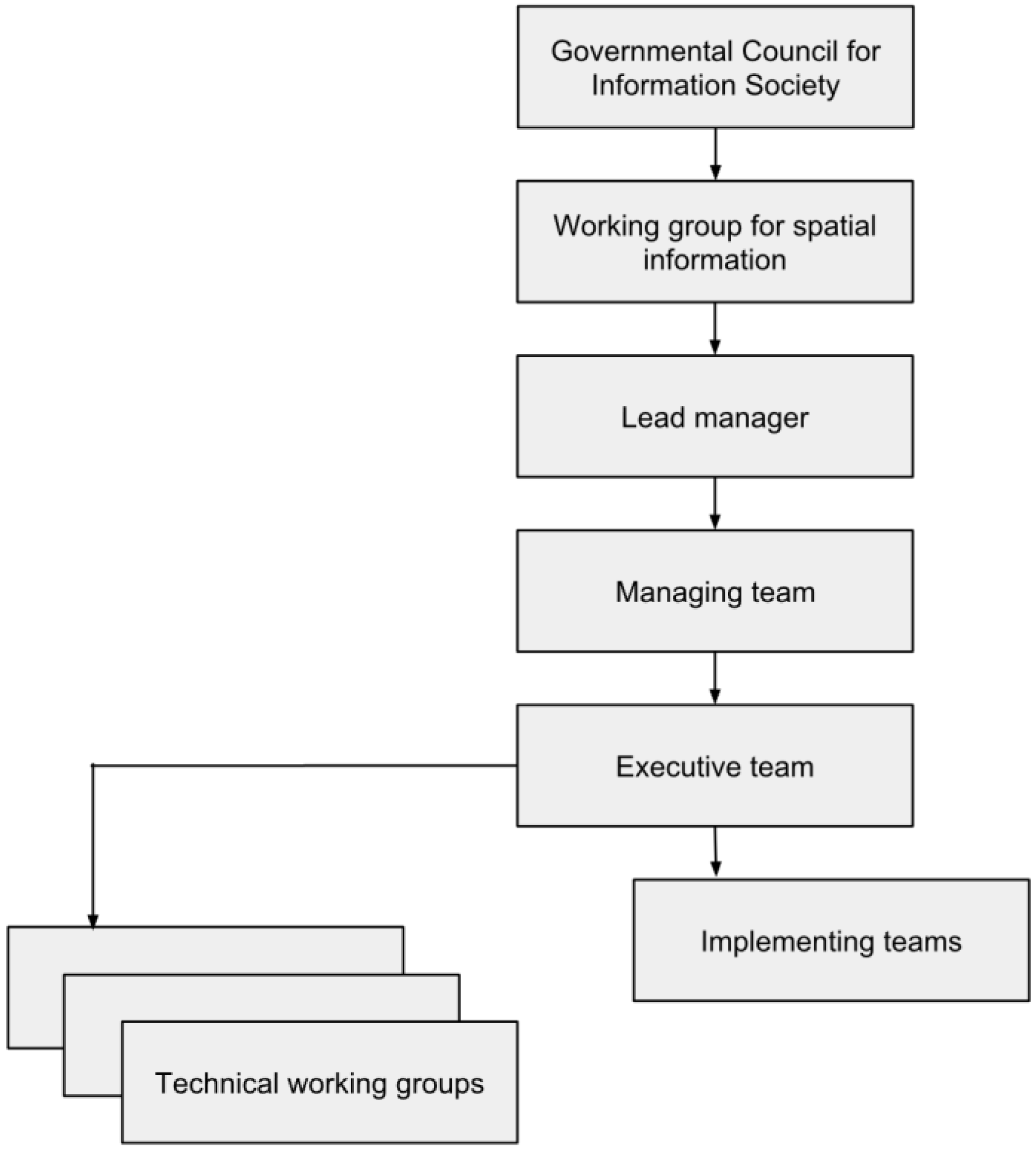
The GeoInfoStrategy is a conceptual material that has a close relation to other strategic documents of public administration and eGovernment. The GeoInfoStrategy defines the principles and strategic aims for effective use of the spatial information in public administration. Furthermore, it supports the development of services and products of the commercial sector based on spatial data and development of eGovernment. For successful creation of the GeoInfoStrategy and the GeoInfoStrategy Action Plan an organization scheme was established (see
Figure 1). The wide spectrum of user target groups was involved mainly through the Consultancy team. The members of this team were public administration bodies, professional associations, or universities and research institutes.
The GeoInfoStrategy contributes to fulfill the government priorities, especially [
45]:
the effective use of ICT in public administration
the rationalization of financial management of the Czech Republic
the development of high quality public services
the development of conditions for the freedom to conduct business, for sustainable economic growth and for increasing the competitiveness of the economy.
The GeoInfoStrategy also helps to fulfill the priorities of particular ministries, e.g., in the fields of environmental protection, cadastre, and protection of cultural heritage.
The implementation of the GeoInfoStrategy will contribute to the creation of a suitable framework for ensuring, and development of, human resources in the whole sector of spatial information. Lifelong learning must be an integral part of this framework [
46]. Furthermore, the implementation of the GeoInfoStrategy has to stimulate research and development in the field of spatial information, especially NSDI.
The initial steps of the GeoInfoStrategy implementation have to be financed by resources of the Czech Republic. These initial investments in the GeoInfoStrategy have to be considered as an integral part of eGovernment. The reason is that the NSDI development is necessary for the modernization of public administration and increasing the accessibility of public sector information. In the future, when the NSDI is established, long-term financial stability has to be ensured. It will require a combination of both public and private sources.
3.1. The Foundations
Due to the exceptional increase of the amount and importance of spatial information dealing with protection of the environment, protection of the population or crisis management, the European Commission decided to establish the Infrastructure for Spatial Information in Europe (INSPIRE) in May 2007. INSPIRE enables the sharing of environmental spatial information among public sector organizations and better facilitates public access to spatial information across Europe. INSPIRE assists in policy-making across boundaries. Therefore, the spatial information considered under the directive is extensive and includes a great variety of topical and technical themes which are described, e.g., in [
47].
INSPIRE, as one of the most important European players in the field of spatial information, is the key European foundation for the GeoInfoStrategy. INSPIRE is based on a number of common principles [
31] which were applied in the GeoInfoStrategy:
Data should be collected only once and kept where it can be maintained most effectively.
It should be possible to combine seamless spatial information from different sources across Europe and share it with many users and applications.
It should be possible for information collected at one level/scale to be shared with all levels/scales, detailed for thorough investigations, general for strategic purposes.
Geographic information needed for good governance at all levels should be readily and transparently available.
It should be easy to find what geographic information is available, how it can be used to meet a particular need, and under which conditions it can be acquired and used.
The INSPIRE principles can be applied on all spatial data, not only data that are mentioned in the INSPIRE annexes. Together with the precise coordination and appropriate legislative framework it can significantly increase the effectiveness of use of spatial data and related processes. Other foundations for the GeoInfoStrategy at a European level are pre- existing geoinformation strategies (e.g., Wales, The Netherlands and Sweden) and also the Public Sector Information Directive (PSI Directive). The Czech Republic has already adapted the legislative framework for access to documents to include re-use of PSI. Regarding sharing and re-use of spatial information in the context of eGovernment the Interoperability Solutions for European Public Administrations (ISA) program plays an important role. The program supports the modernization of public administration through interoperability solutions. For example, ISA Action 2.13, Establishment of a European Union Location Framework (EULF), and ISA Action 1.17, A Reusable INSPIRE Reference Architecture (ARE3NA), are complementary and combine to focus on spatial information and services aspects within the ISA program [
48]. An ISA Working Group on Spatial Information and Services has been established under the main ISA Committee to help facilitate the dialogue between the e-government and geospatial communities, in particular between ISA and INSPIRE, and to play an important advisory role on the two geospatial ISA actions, EULF and ARE3NA. From the research perspective, the establishment of a European Union Location Framework will bring to the research and academia more innovative and authoritative research (better access to research data, richer data sources and reusable software).
The foundations for the GeoInfoStrategy at a national level are the activities that were realized in the key public administration bodies (ministries, Czech Office for Surveying, Mapping and Cadastre, Association of regions of the Czech Republic, Union of Towns and Municipalities of the Czech Republic). Next, in June 2015 the document Strategie Implementace směrnice INSPIRE v České republice (The Strategy for the implementation of the INSPIRE Directive in the Czech Republic) was approved [
49]. This document describes the roles and processes in the field of spatial data harmonization and accessing the harmonized data to the national and European geoportal, and served also as an important foundation for the GeoInfoStrategy at a national level. However, for GeoInfoStrategy purposes, it is necessary to describe and standardize the processes dealing with the whole lifecycle of spatial data and also the processes dealing with NSDI as a whole. The crucial foundation for GeoInfoStrategy is a system of basic registers, especially the Register of territorial identification, addresses and real estate.
3.2. The Vision and Aims
The vision of the GeoInfoStrategy is that, in 2020, the Czech Republic is a knowledge society effectively using spatial information. To fulfil this vision, it is necessary that spatial information and services will be used in every aspect of public life. The services that will be created with relevant spatial data will support competitiveness, safety, social cohesion and sustainable development. The accessibility of spatial information and services enables the public sector to offer modern and high quality public services. The GeoInfoStrategy has four strategic aims.
The first strategic aim is to ensure guaranteed services of public administration for the effective management and use of spatial information and wide use of these services by society. It is necessary to define the life situations for which it is suitable and useful to use spatial information and services information for society. Society has to use the already existing services and needs to specify and create missing services, or improve the quality of insufficient services. This is not possible without the legal, organizational and technological framework which enables the creation of the new services and third party products.
The second strategic aim is to establish the national infrastructure for production, management and interlinking of the spatial data funds of public administration. The development focuses on the technical part (information systems, communication services), data interoperability and services (sharing services allows the management and use of spatial information). It is also necessary to define the global system architecture of NSDI. Furthermore, it is crucial to adopt the standards for technical regulation of NSDI and specify the conditions for open services. The publishing of spatial data of public administration as open data must become a standard. The multiple production of spatial data must be eliminated.
The previously mentioned strategic aims cannot be reached without improving the quality and further development of the spatial data funds. This is the third strategic aim. It is necessary to define the spatial data sets that the public administration needs in order to cover all its activities. Furthermore, a way of spatial data production, management and updating has to be declared. Another aspect that must be taken into account is that it is required to be quality data and legally binding. Based on the analysis of the public administration requirements, it is needed to define the content of the National Set of Spatial Objects and prepare the legal, technical, institutional and economic conditions for its creation.
The fourth strategic aim is the coordination and development of institutional infrastructure for the field of spatial information. This strategic aim concerns mainly the coordination of legislation issues, ensuring skilled human resources and ensuring financing for research and development in the field of spatial information. The complex analysis of current legislation dealing with spatial information has to be done. It is necessary to consider the stabilization and further development of the education system and ensure the legal and institutional framework for the coordination and improvement of research and innovations.
3.3. The Design of the GeoInfoStrategy
Up-to-date spatial data are the integral part of every spatial data infrastructure. The quality of decision making processes strongly depends on the correctness of spatial data. At the same time there is a strong social demand for guaranteed data to ensure such high-quality decision making. Geoportals—gateways to geographic content and capabilities—are a key element of NSDI. A web-based portal for one-stop access to maps, data and other spatial data and services should be established [
23]. Therefore the approval of the GeoInfoStrategy by the Czech Government is a very important milestone in building the Czech NSDI.
The basic condition for development of the NSDI is a common definition of the model of the real world. Most potential target users must agree with this model. Only on the basis of this model, is it possible to define a set of fundamental object types. This leads to the definition of fundamental data bases of spatial data at the highest level of detail. In [
50] the essential principles on which the fundamental data bases can be developed are proposed.
The key topics that represent the design part of the GeoInfoStrategy are as follows:
creating National Set of Spatial Objects
changing the regulatory framework
setting of spatial information activities coordination
building of National Integration Platform for Spatial Information
building of National Geoportal
provision of spatial information services in public administration
publishing open data and open services in spatial information field
using spatial information and spatial services by third parties
human resources and training in spatial information field
fulfillment of international obligations and international interoperability.
The creation of National Set of Spatial Objects reflects the most frequent request of the main target groups working with spatial information. Therefore the major attention has been devoted on the analysis of already existing spatial data sets, related services and corresponding legislation. It was concluded that it is necessary to identify and describe all spatial data sets which are essential for public administration support information systems. The minimal contents and technical parameters of the fundamental spatial data sets have to be defined as well as the requirements on their complement, changes and modification. It is also necessary to ensure management of the data, capturing the changes of the real world. In this context, the development of already existing spatial data sets (e.g., RTIARE) is guaranteed.
3.4. The National Set of Spatial Objects
There is a strong emphasis on the creation of National Set of Spatial Objects in the GeoInfoStrategy (NSSO). NSSO is defined as the source of guaranteed and reference geographic data at the highest possible level of detail for selected objects of the real world, covering the whole territory of the Czech Republic. NSSO will be widely used, mainly in the decision making processes of public administration, by private sector and educational and research organizations. NSSO will be implemented as an information system at the governmental level with guaranteed standards of data quality, data flows and services. The administrator of NSSO will be responsible for building this information system and its maintenance. The primary task of the NSSO administrator is to identify the current data flows in public administration and ensure the import of these data into NSSO. Furthermore, NSSO will enable the creation of some derived spatial objects by data model generalization.
The NSSO feasibility study will define the technical, institutional, legal and economic conditions for the ongoing input of information into NSSO. The important role of the NSSO administrator will be routine and continuous integration of the data contents.
NSSO will be fulfilled only by the guaranteed and harmonized data created according to the certified procedures. The certification authority will be the administrator of NSSO who coordinates all necessary methodical, technical and technological processes and is supported by all public administration bodies.
The main data sources for NSSO are:
the outcomes of land surveying activities in the public interest (e.g., fundamental state map series, thematic state map series or maps of town utilities)
the outcomes of land surveying activities for own use (e.g., preparation of the large-scale and extensive investment projects)
the geodic part of the documentation of the actual construction being realized
the information systems of the administrators of underground utilities.
Regarding the fundamental and thematic state map series as a source for NSSO, the most important is mapping of the important and relevant areas of interest (e.g., built-up areas). The mapping activities of particular NSSO objects should be unified with regard to technical and qualitative parameters.
3.5. The Benefits of the GeoInfoStrategy
The implementation of the GeoInfoStrategy will result in an NSDI that will enable the effective sharing of spatial data among the public administration bodies. Next, the GeoInfoStrategy enables the creation of huge amount of services working with spatial data. Selected services will be offered as open while some services will be available based on particular conditions (license, financial, technical). It will be possible to receive quite new information by the integration of data from various information systems. Up to now, such information has not been acquired mainly due to the high price.
The new services working with spatial data bring a real benefit for all target user-groups. Citizens and business people will solve life situations dealing with transportation, building construction, receipt of aid in the sector of forest management, and handling accidents or emergencies more effectively. The self-governments will efficiently manage their property, ensure public services (e.g., waste disposal), or support entrepreneurship and tourism. The development of shared services will help in the area of spatial planning, environment protection, culture heritage, etc. Public authorities can efficiently plan the allocation of public funds. The creation of new services using spatial information is a significant stimulus for further development of ICT and research and development.
For the private sector two conditions are crucial:
- (1)
The spatial data administered by the state are guaranteed and unified across different bodies of the public administration.
- (2)
The conditions under which the spatial data are provided within an NSDI are understandable and incontestable.
The fulfillment of these requirements is necessary for the enhancement of the competitiveness of industry, farming, transportation, research and development and other fields which depend on use of spatial data and related services (e.g., location-based services). The impact of the GeoInfoStrategy is that the private sector will receive non-discriminatory access to the data sources of public administration. The access should be provided in electronic form with a standardized interface enabling automatic processing of spatial data.
The public demand is motivated by the necessity to solve life situations where the presentation of supporting documents containing spatial information is required. The key benefits of the GeoInfoStrategy to the public are as follows:
4. The GeoInfoStrategy Action Plan
The set of measures for development of the regulatory framework in the field of spatial information were defined in the GeoInfoStrategy Action Plan. They include, in particular:
- (1)
The specification of the essential input analysis (mainly the analysis of public administration support information systems working with spatial information, analysis of the legislation, analysis of forthcoming projects in the field of spatial information etc.).
- (2)
The proposal of the method of coordination including the specification of the coordinating authority.
- (3)
The proposal of the set of technical measures for the first period of implementation of the GeoInfoStrategy Action Plan including the identification of projects essential for ensuring detailed technical specifications (e.g., the proposal of the National Set of Spatial Objects, the proposal of National Spatial Data Infrastructure).
Due to the GeoInfoStrategy relation to the INSPIRE initiative some measures are mainly focused on INSPIRE. Especially the measures Analysis of spatial data sets, metadata and functionality gathered during the INSPIRE implementation and Implementation of the INSPIRE directive. Within the scope of these measures the further implementation of INSPIRE in the Czech Republic is described. The measures contain descriptions of activities which are mandatory according to INSPIRE and which have not yet been solved. Furthermore, these measures describe activities that INSPIRE directive states as potential, i.e., the Member States are not required to implement them.
Some other measures have a close relation to INPIRE, for example, the creation of the Czech National Geoportal as a single access point for data and services of NSDI. The creation of the Czech National Geoportal will be based on experience gained during the development of the INSPIRE National Geoportal, which is already a part of NSDI.
For future planning it is also necessary to consider the fact that some ISA methodologies and guidance for ensuring interoperability of public administrations in Europe will become legally binding, for example, the European Interoperability Framework (EIF).
The measures will be financed mainly from the Czech Republic budget; however, some measures can be financed from European Union funds. For further development of eGovernment and successful implementation of the GeoInfoStrategy Action Plan the Ministry of the Interior requires the strengthening of the role of the Governmental Council for Information Society that is the top-level supervisor (see
Figure 2).
The Governmental Council for Information Society will submit the reports on the implementation of the GeoInfoStrategy Action Plan to the Government including the financial analysis.
4.1. The Evaluation and Monitoring of the Implementation and the Framework of Indicators
The GeoInfoStrategy Action Plan will be regularly evaluated and updated. An effective tool for measuring the progress made towards the GeoInfoStrategy Action Plan implementation is an appropriate framework of indicators. This framework together with the monitoring system should, in time, detect any insufficient achievement of objectives.
Within the scope of the GeoInfoStrategy Action Plan three types of indicators are distinguished:
- (1)
The indicators of output showing the implemented measures. They give information about the immediate outputs of the implementation.
- (2)
The indicators of result directly linked to the immediate effects of the implementation. They serve as an evidence of the achievement of aims and objectives.
- (3)
The indicators of impact concerning the benefits beyond the immediate effects of the implementation. They are related to the strategic aims and are important especially for strategic decisions.
4.2. The Risk Management
During the implementation of the GeoInfoStrategy Action Plan the standard tools for the risk management will be used, especially the risk register. This register contains all risks identified during the preparation of the GeoInfoStrategy and the GeoInfoStrategy Action Plan. The set of potential risks for the implementation of the GeoInfoStrategy Action Plan was mainly identified by regular outcomes of the technical working groups and consultancy team (see
Figure 1). During the process of risks identification several aspects were considered:
information stated in the GeoInfoStrategy and the GeoInfoStrategy Action Plan
the nature of these documents
the environment in which the GeoInfoStrategy Action plan will be realized.
The risks were classified according to the probability of occurrence and the expected impact. Based on this classification, the significance of the risk was calculated. Overall 13 risks were identified [
51]. The following list contains the identified risks ordered from the most important one (
i.e., with the highest significance):
the political risk
the inappropriate setting of the GeoInfoStrategy Action Plan
the delays during the preparation of the new legal framework
the delays in public procurement procedure,
the discrepancy between the progress chart if implementation and financial instruments
the lack of human resources
the ineffective coordination of implementation of the GeoInfoStrategy Action Plan
the inappropriate or unfeasible conception of the technical solution
the non-systemic promoting of the interests of particular ministries
the delay with the implementation of the GeoInfoStrategy Action Plan
the insufficient allocation of resources from the national budget
the insufficient use of the standards
the loss of public confidence in the GeoInfoStrategy.
The risk management processes are going to be set up in accordance with the usual methodologies in the field. There must be a sufficient scope for early identification of the risk and adoption of most suitable measure for its elimination. The continuous updating of the risk register and ensuring corrective measures of supervision are essential parts of the risk management.
From the procedural point of view, the risk management at the top level of the GeoInfoStrategy Action Plan implementation is connected to the Governmental Council for Information Society and Working group for spatial information (see
Figure 2). They serve as supervisory and managing authorities. The executive role will be assigned to the coordinators of particular measures. The technical working groups have an irreplaceable role during the practical realization of risk management.
Within the risk management framework the following roles and responsibilities are defined:
The supervisory and managing authorities are mainly responsible for the whole risk management system. They approve the risk management procedures, guidelines, critical risks and the ways of their management. Furthermore, they approve communication about the risk management and its outcomes. The managing authorities assign the identified risks to their owners.
The coordinators of the particular measures defined in the GeoInfoStrategy Action Plan mainly inform the managing authorities about important risks and their development. They also provide an indication of the extent to which the guidelines for the risk management are satisfied. Furthermore, the coordinators propose a communication about the risk management and supervise a realization of approved communication actions.
The owner of the risk periodically updates data and indicators about his risks, monitors them and issues early warnings. He proposes measures for the risk elimination to the managing authorities and tries to improve the procedures or methods used for the management of his risks in accordance with the managing authorities’ guidelines.
Whoever from the organizational scheme identifies a new risk, shall notify the managing authorities. The new risk is classified according to the probability of occurrence and expected impact and added to the risk register.
5. Discussion
The effective governance of a knowledge society in accordance with legislation presents the public administration, local self-governments, institutions and citizens with a number of obligations. Due to the fact that the state requires the fulfillment of obligations, it is necessary to create equivalent conditions and environment. The Czech Republic is also bound by international conventions and directives, for example INSPIRE.
The public administration does not always use existing spatial information effectively—they are not considered as spatial—the connection to the Register of territorial identification, addresses and real estate as one of the basic registers is not required, spatial analysis and modeling are not used. It must be stated that the greatest philosophical and psychological difficulty of public administration is probably a lack of confidence in its own data. The optimal usage of data produced and managed by the public administration is one of the key areas which are necessary to consider for the successful development of eGovernment. From this perspective the state has an essential role in production, management and provision of the guaranteed fundamental spatial data.
The four stages of development of the NSDI are described in [
6]: stand alone, exchange, intermediary stage and the network stage. In the network stage, a broad support exists for the NSDI vision, which is continuously reviewed by a variety of stakeholders through open communication channels. The vision, together with the leadership, communication channels and ability of the spatial information community for self-organization are four critical organizational components of the NSDI [
6]. From this perspective, the GeoInfoStrategy can be seen as a beginning of the network stage of the NSDI development in the Czech Republic. The vision of the GeoInfoStrategy is widely supported and shared between all the stakeholders and target user-groups. The support at the governmental level is also crucial for successful GeoInfoStrategy implementation (see
Figure 2). The communication plan defined in the GeoInfoStrategy should enable the exchange of thoughts, messages or information between all participating parties and the general public. Also, all the key stakeholders should recognize their responsibility for their part of the NSDI. The NSDI development takes place in a dispersed scenario in which the final purposes, functionalities and composition of the SDI change dynamically and can only be specified vaguely [
52]. This argument implies that the needs of communities change over time and that, therefore, the ideal will change accordingly [
23].
During the analytical stage of preparation of the GeoInfoStrategy the needs of target groups (public administration bodies, the commercial sector, professional organizations, etc.) were examined. The highest priority is the availability and accessibility of the fundamental spatial data at the highest level of detail covering the whole territory of the Czech Republic. There is a strong demand on the creation of National Set of Spatial Objects as the source of guaranteed and reference geographic data at the highest possible level of detail for selected objects of the real world.
The coordination of the implementation of the GeoInfoStrategy action plan is under the responsibility of the Working group for spatial information that was established under the Governmental Council for Information Society (see
Figure 1). The members of this working group are the representatives of the ministries, Czech Office for Surveying, Mapping and Cadastre, Association of regions of the Czech Republic and Union of Towns and Municipalities of the Czech Republic. The formation of this working group should eliminate a risk of the insufficient management of the GeoInfoStrategy Action Plan. However, against the original idea of the GeoInfoStrategy, the representatives of the commercial sector and academia are not members of this working group; also the representatives of the Ministry of Education, Youth and Sports are missing. This presents a potential risk for delivering the objectives dealing with the development of human resources and research and development. In fact, the measures dealing with human resources were proclaimed as very important, so that the GeoInfoStrategy does not have only the technical and coordination substance.
There is currently insufficient support for research and development in the field of NSDI, which jeopardizes its quality and potential. The crucial scientific challenge is how to produce and efficiently manage the huge amount of the reference data sets of modern technologies. The measures described in the GeoInfoStrategy Action Plan will be realized according to the time schedule. At the beginning, the analytical measures will be addressed. The outcomes from these analytical measures will influence the follow-up research and implementation projects. These projects will be realized by various institutions and consortiums and, therefore, it is necessary to guarantee a standardized form of the documentation of the outputs and related metadata. It is necessary to ensure the processes which will allow an availability and reuse of the results of the research projects. The Research Data Management (RDM) should be used to support these processes. RDM comprises all relevant processes and measures which ensure that research data, created in the context of a research project or institution, are well-organized, preserved, backed up, documented, accessible, and re-usable [
53], [
54]. The results of research projects have to be available during the whole period of the GeoInfoStrategy implementation. The metadata system will be based on ISO 19115:2014 Geographic Information—Metadata. This standard defines the schema required for describing geographic information and services by means of metadata. It provides information about the identification, the extent, the quality, the spatial and temporal aspects, the content, the spatial reference, the portrayal, distribution and other properties of digital geographic data and services [
55]. The research institutions which participated in preparation of the GeoInfoStrategy already have experience with the RDM, for example, the Plan4Business platform [
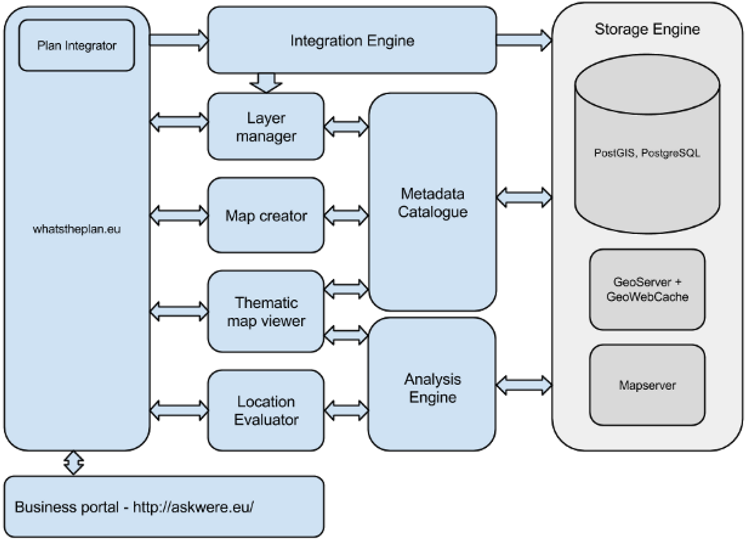
56] for aggregation, processing and analysis of urban and regional planning data. At the moment, the data pool contains 25% valid spatial plans in Europe, accessible without legislation restrictions. This platform integrates research data and results of several European research projects (e.g., Plan4all—European Network of Best Practices for Interoperability of Spatial Planning Information, SDI4Apps—Uptake of open geographic information through innovative services based on linked data, Open Transport Net) and enables browsing the content, viewing the thematic compositions, downloading certain datasets from the data pool or using the developed Application Programming Interface (API).
Figure 3 demonstrates the scheme of the platform, which is expected to become an important part of future R & D projects.
Other fields where extensive research has to be done are location awareness, location-based services, now casting, 3D concepts and implementations (e.g., 3D cadastre), augmented reality, sensor networks and using the data from social networks for local forecasts, etc. Further development in the field of spatial information also needs the unification of geodetic reference systems. It is necessary to ensure the transformation services for all mandatory coordinate systems.
6. Conclusions
The effort to coordinate the activities of particular public administration bodies and companies in the field of spatial information was promoted by the GeoInfoStrategy. The cross-sectoral character of the GeoInfoStrategy is based on the vision that in 2020 the Czech Republic will be a knowledge society effectively using spatial information. The services working with relevant spatial data will be used in all areas of life and support competitiveness, safety, social cohesion and sustainable development. The public sector will offer high quality services due to the accessibility of spatial information.
The knowledge society is characterized by an optimum use of spatial information. In the future, it is not effective to establish particular public administration support information systems containing the ministry-specific data. This leads to duplicated data and also data interoperability cannot be reached.
The global objective of the GeoInfoStrategy is to create a framework for the production, management and effective use of spatial information in society and thus support the socio-economic growth and competitiveness of the Czech Republic. The primary requirement is to use relevant and guaranteed spatial information and to use it in the public administration support information systems to ensure that decision-making processes are transparent, correct and beneficial for the whole of society.
There is a strong social demand on the creation of guaranteed and reference geographic data at the highest possible level of detail. It results in NSSO that will be used mainly in the decision-making processes of public administration and by private sector and research organizations. NSSO will be implemented as an information system at the governmental level with guaranteed standards of data quality, data flows and services. The main advantage of this approach is that data can be reused. NSSO will enable the creation of some derived spatial objects by data model generalization.
The principles defined in the GeoInfoStrategy are general and can serve as best practice for other countries building an NSDI that should meet the requirements of all target groups working with spatial information.


