Developing Web-Based and Mobile-Based GIS for Places of Worship Information to Support Halal Tourism: A Case Study in Bukittinggi, Indonesia


Abstract
:1. Introduction
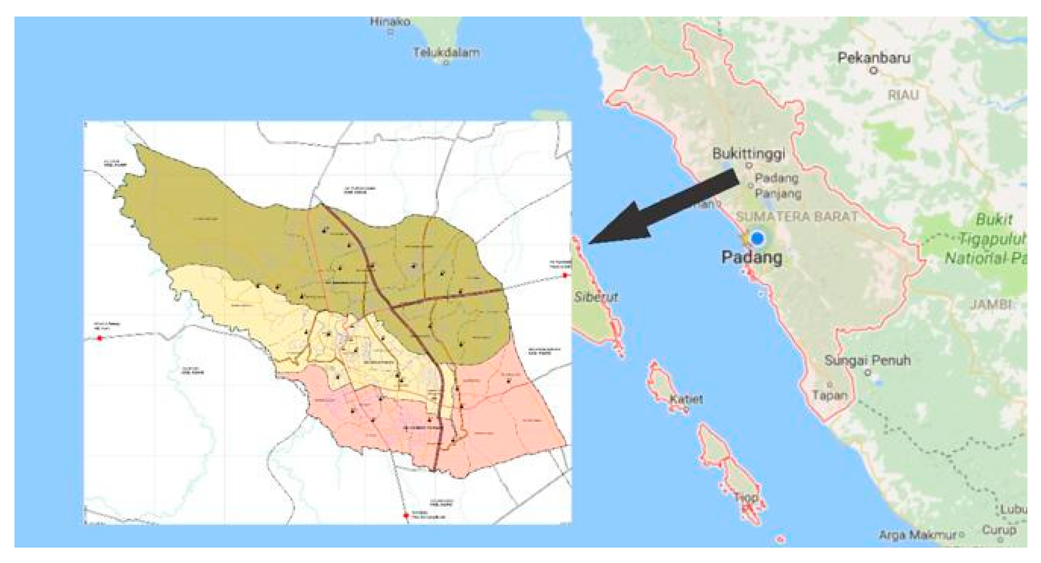
Study Area
2. Materials and Methods
3. Results
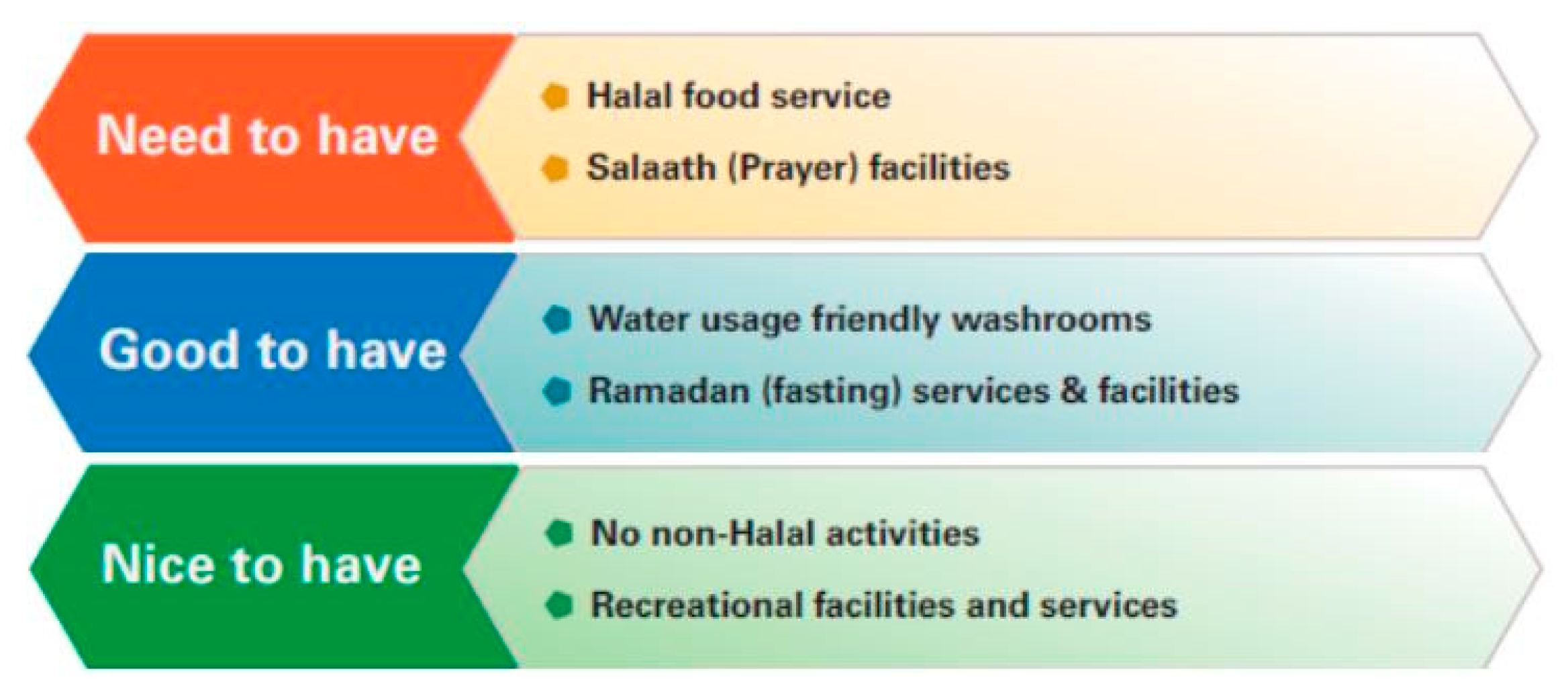
3.1. Needs Analysis and Design
- Tourists who come in groups using a tour bus need a mosque with extensive parking facilities. Individual tourists need information about the route to the mosque and public transport route to reach it [1,22,23]. The importance of information regarding public transportation for tourism has been expressed by [22,42,43].
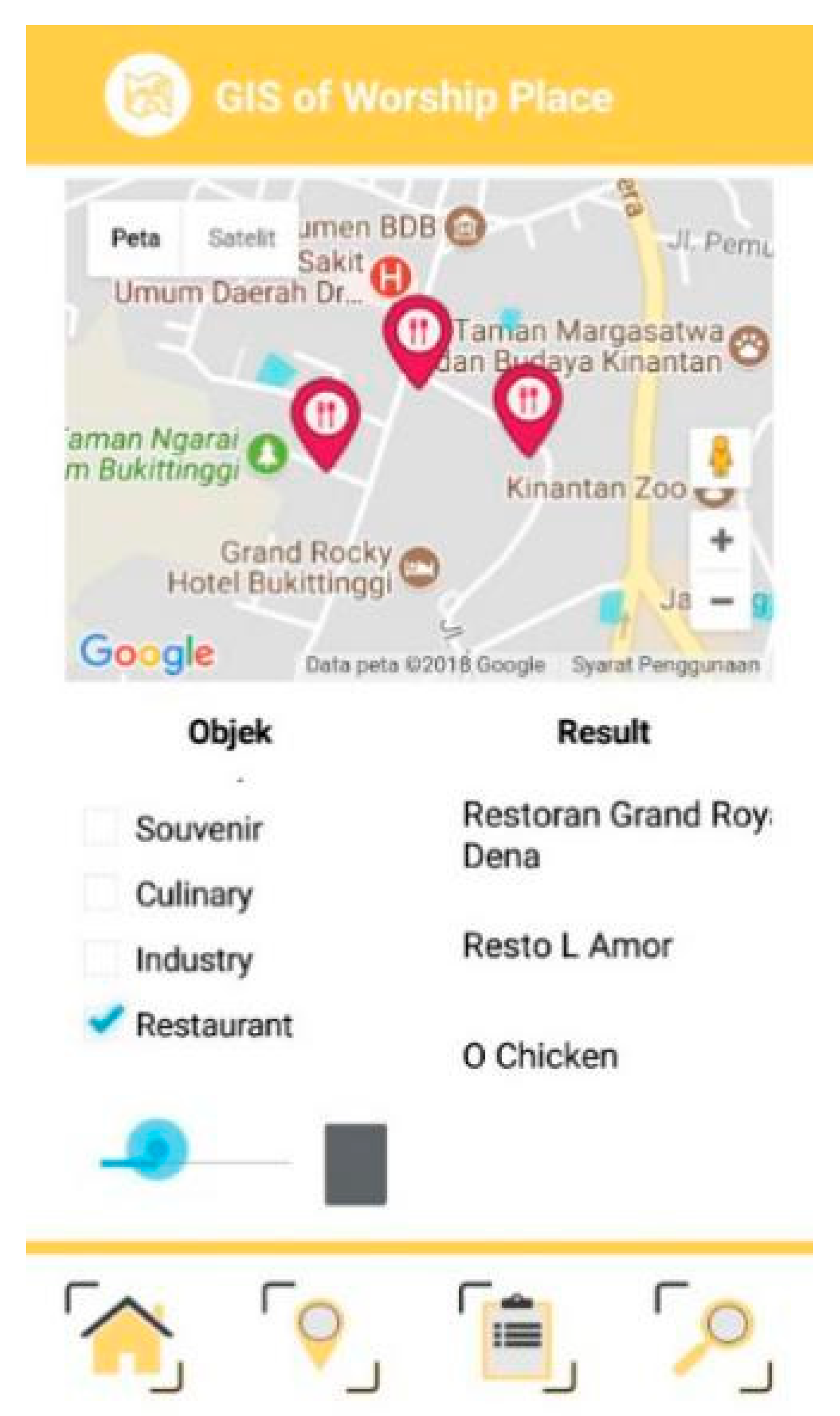
- After prayer, tourists will continue their tour where they can go to halal restaurants or visit other attractions. Hence, they also need information about tourism objects and other tourism facilities around the mosque.
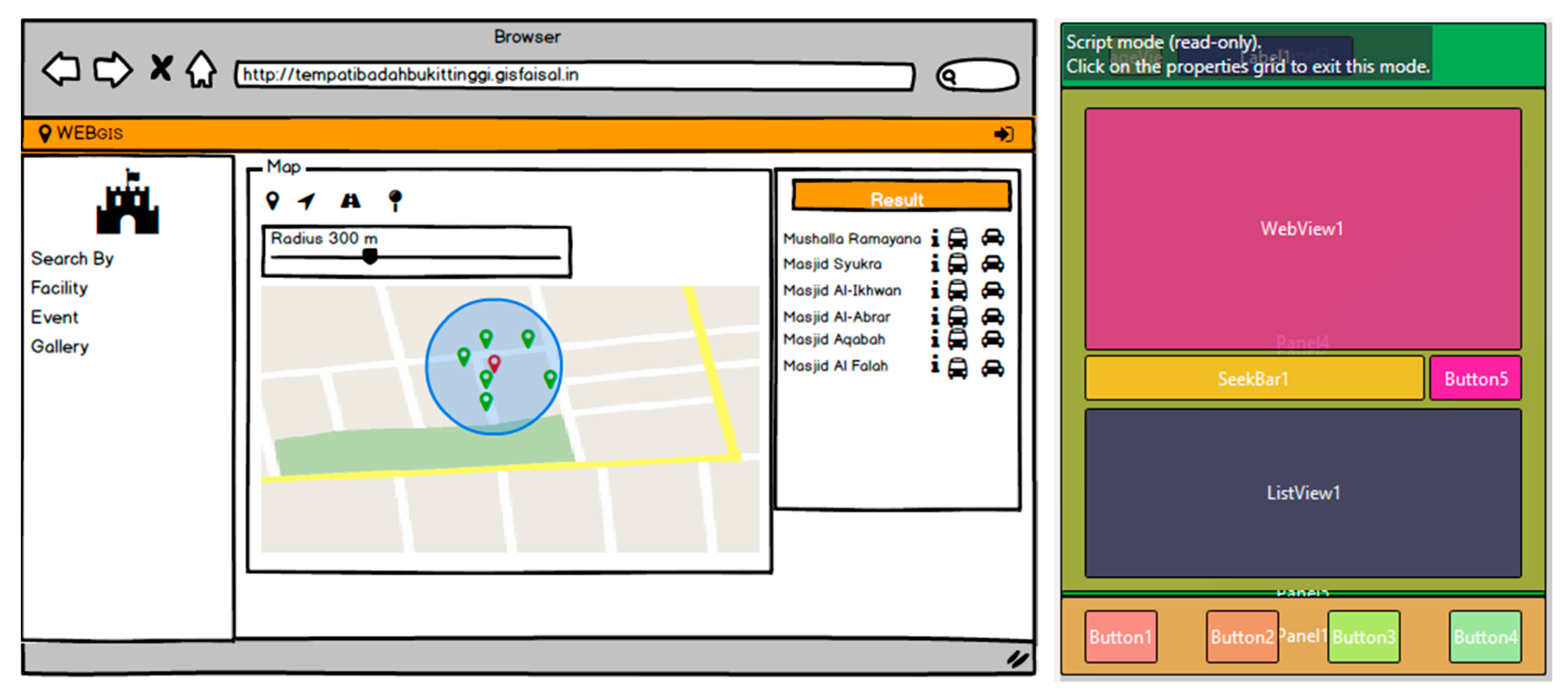
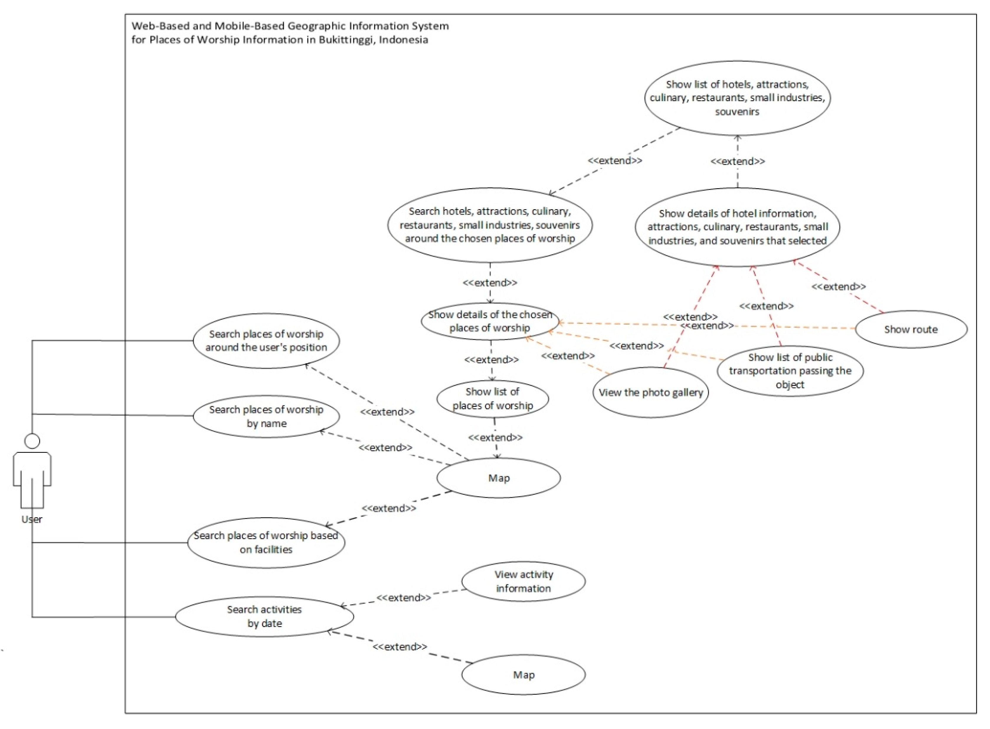
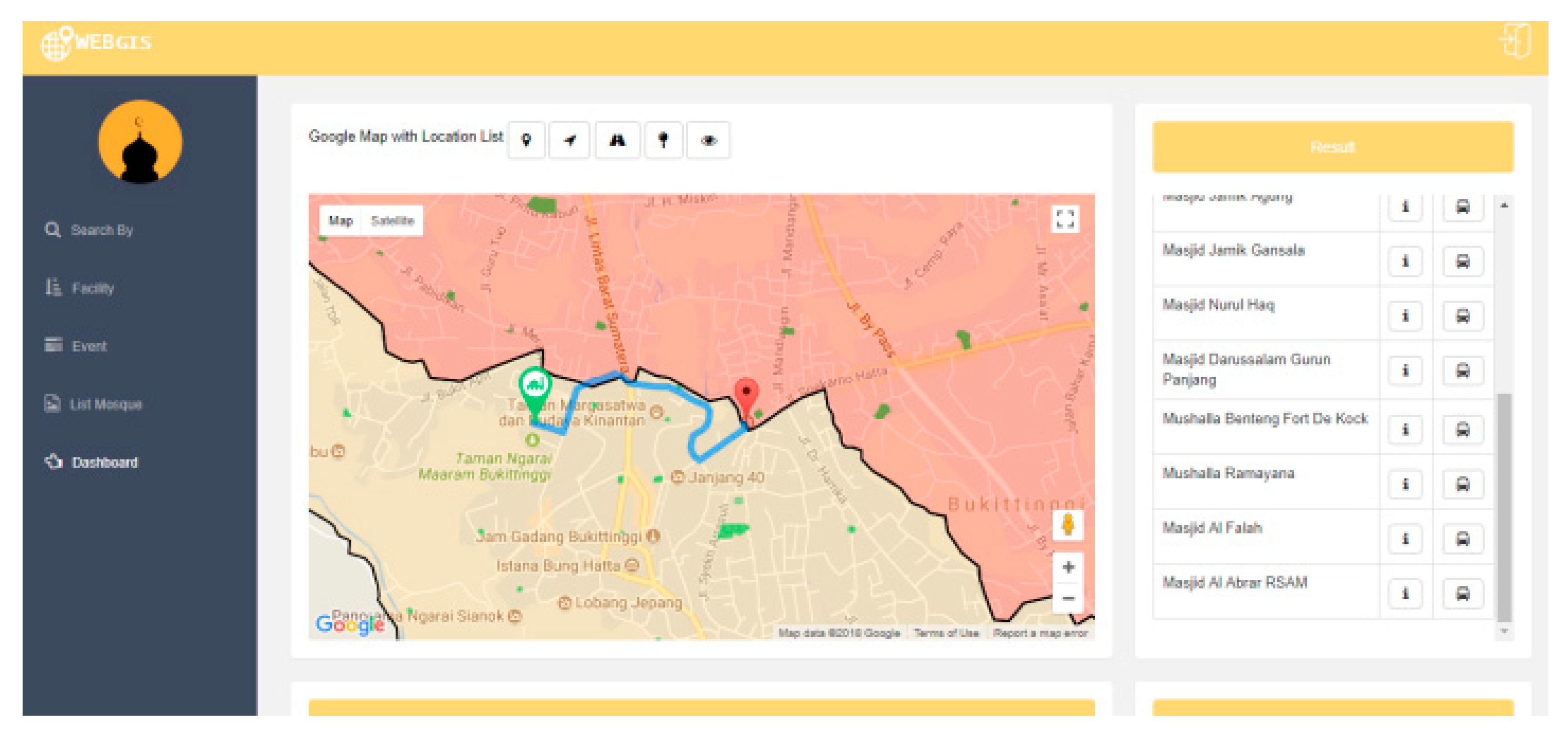
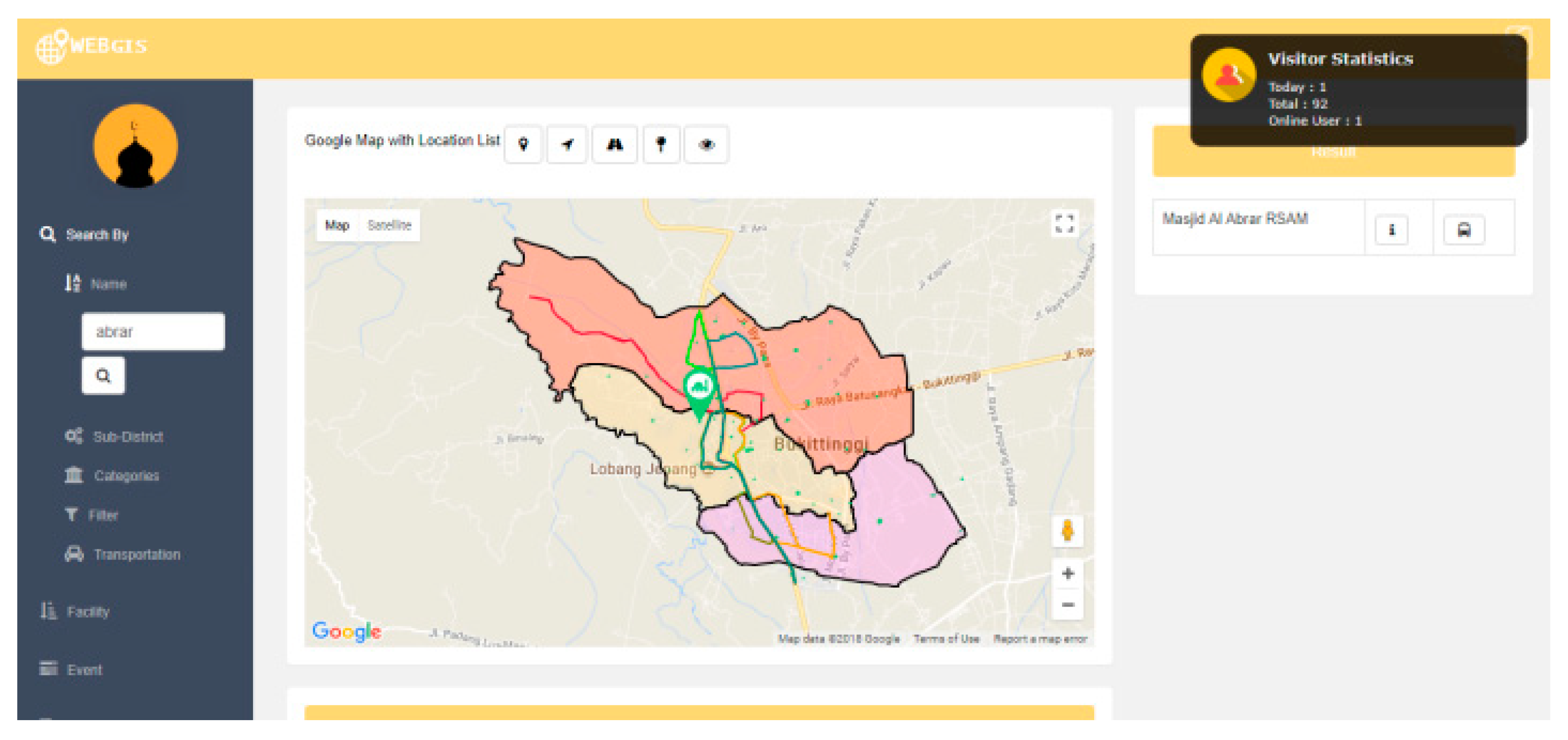
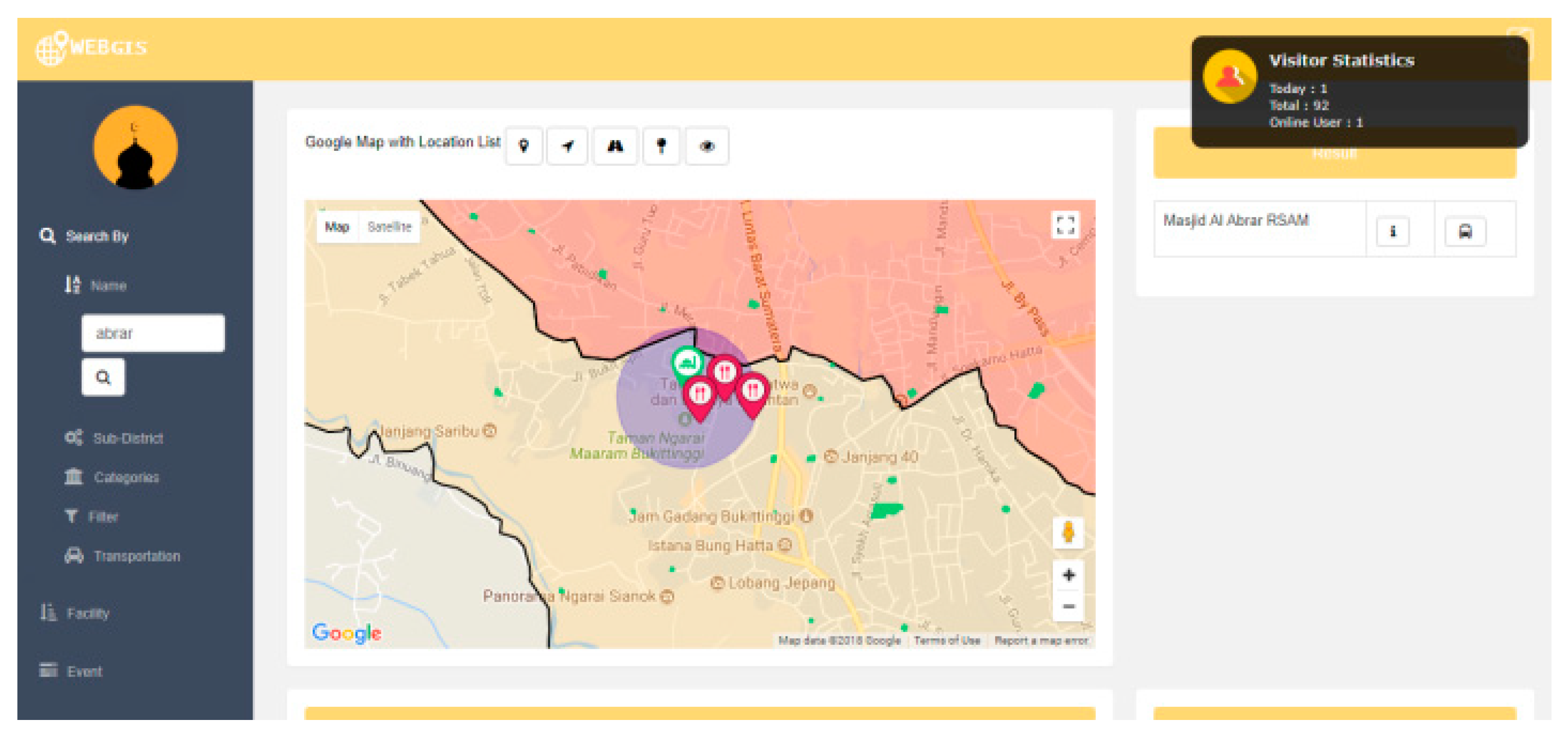
- Users can search for mosques based on some criteria including distance, name, and available facilities. The GPWI should display information as follows:
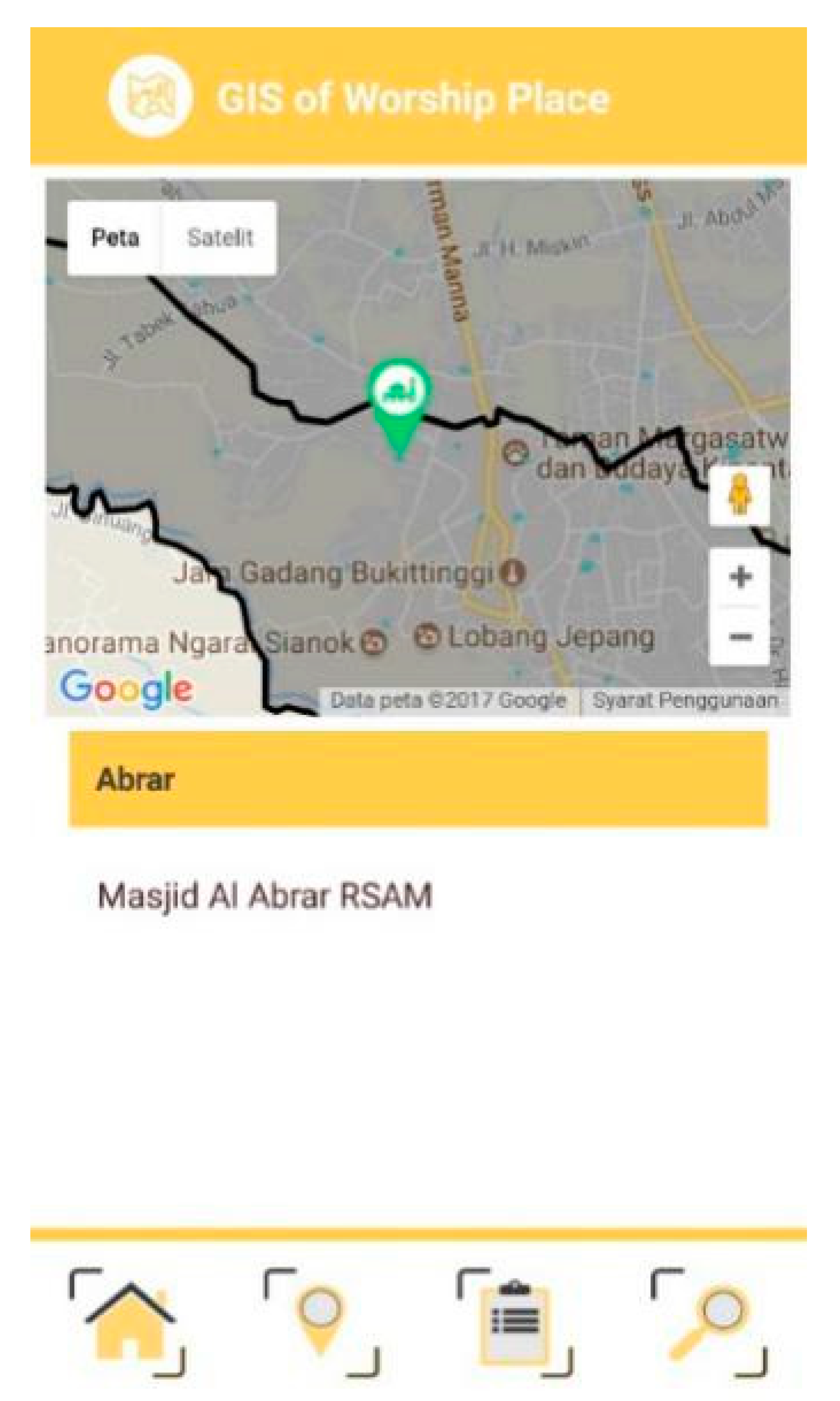
- Map of the mosque.
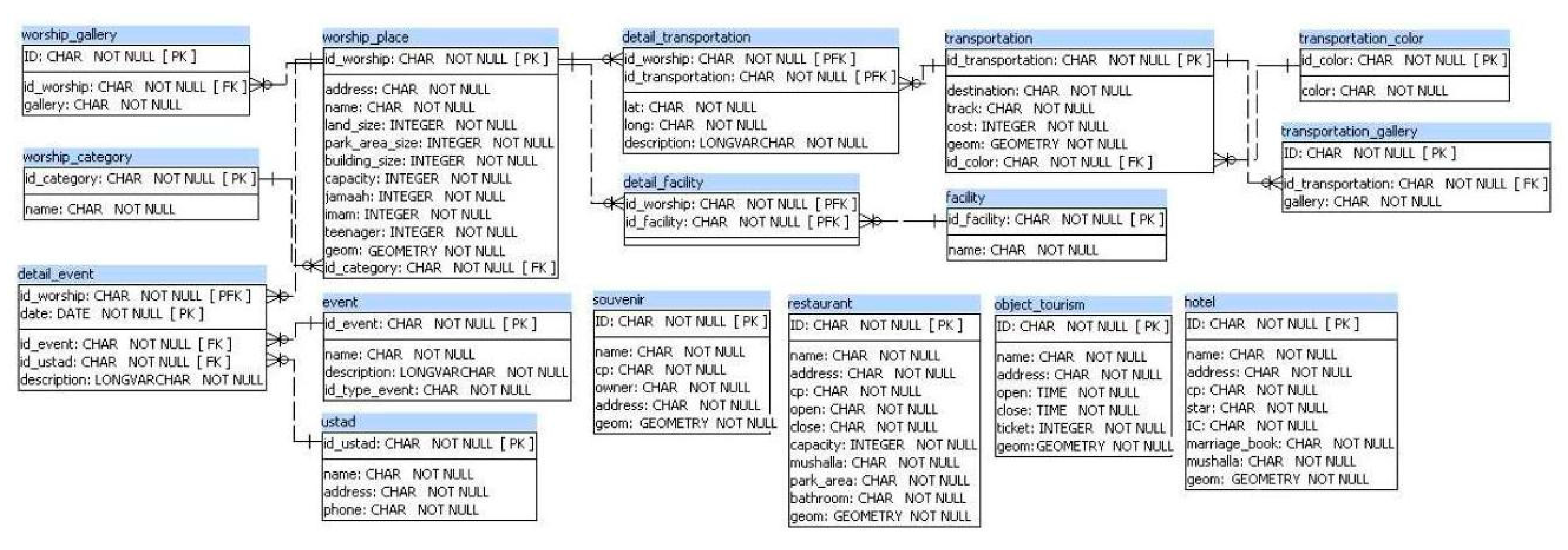
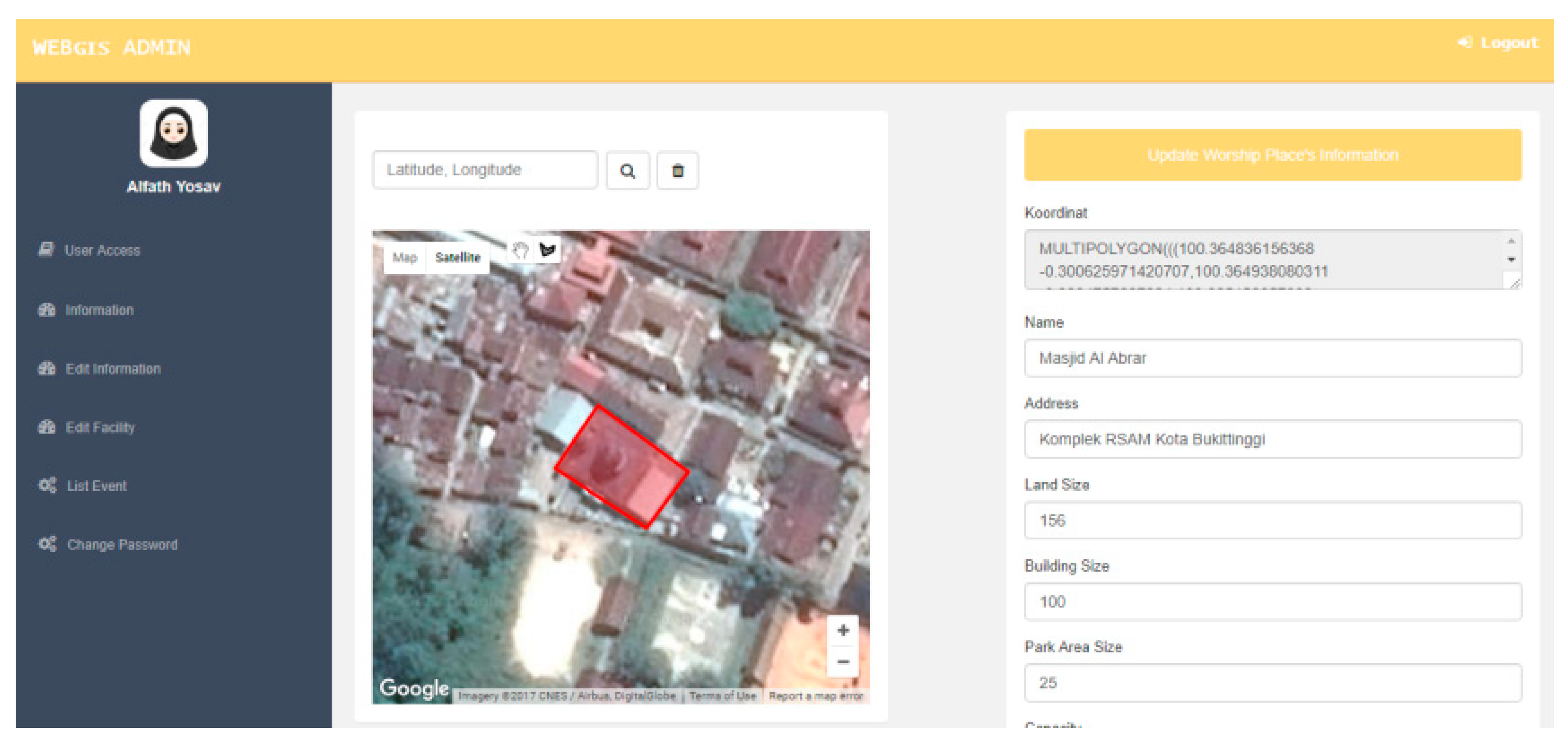
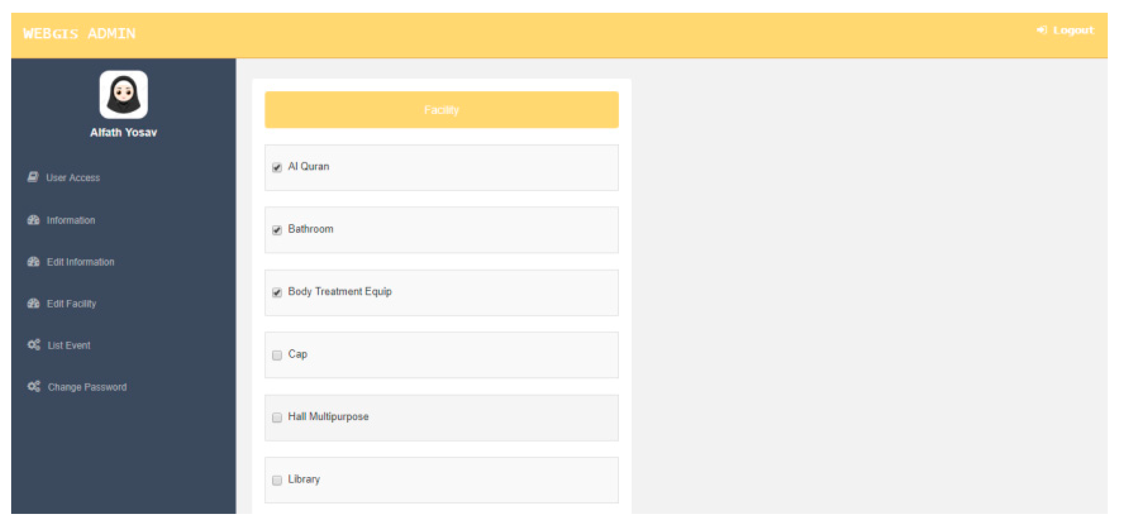
- Detailed information about the mosque: name, address, land area, building area, parking capacity, number of priests, number of prayer attendees, number of adolescents, categories, pictures, and administrator identity.
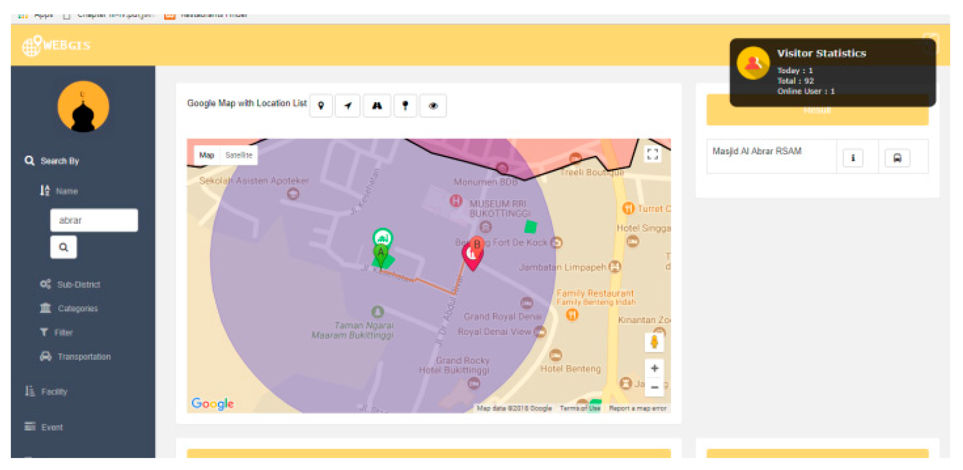
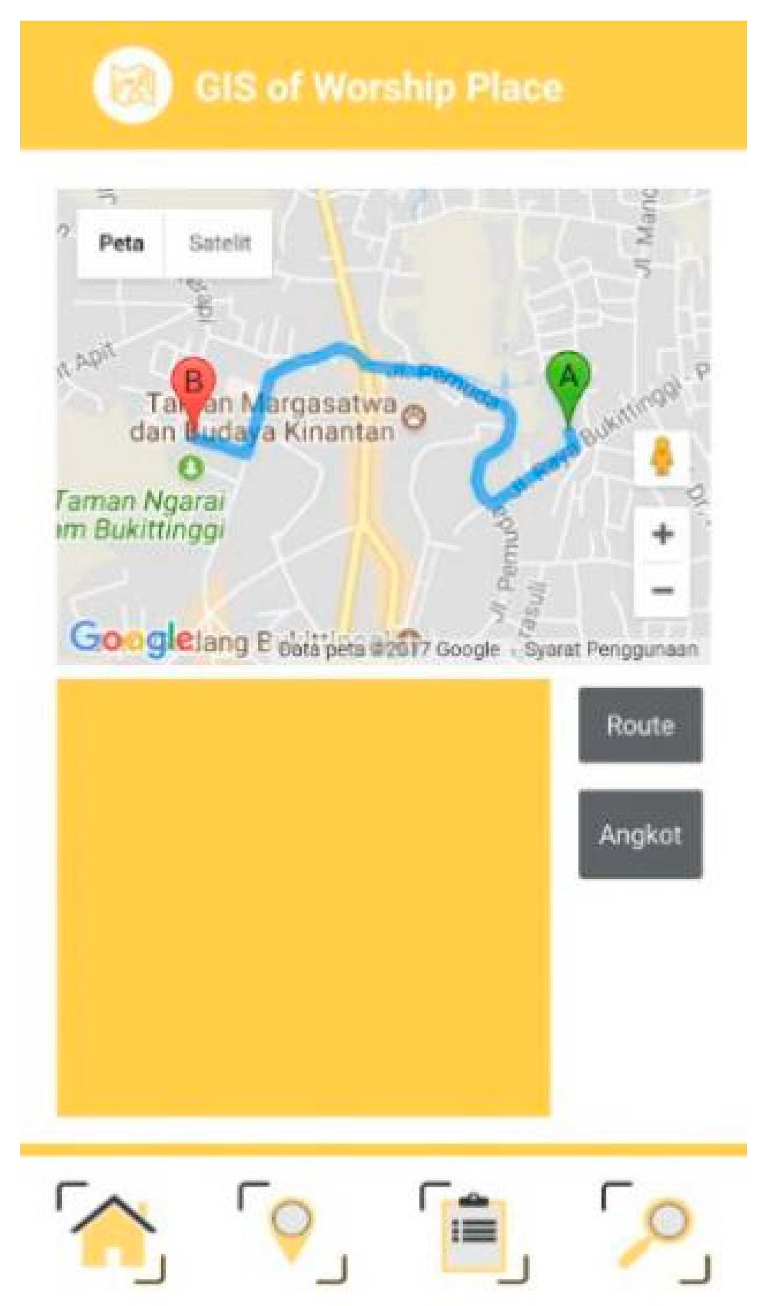
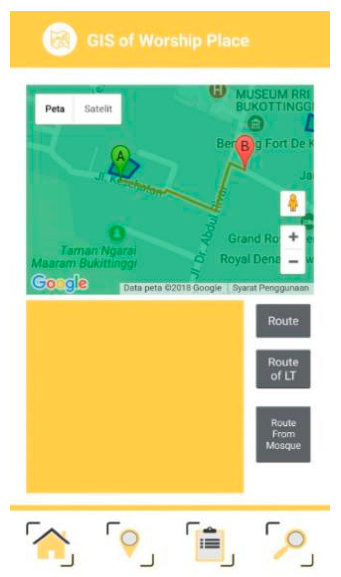
- Public transport route.
- Map route.
- Object map and tourist attractions around the mosque: hotels, restaurants, small industries, and souvenir stores. Users should also be given detailed information regarding the route to reach the destinations.
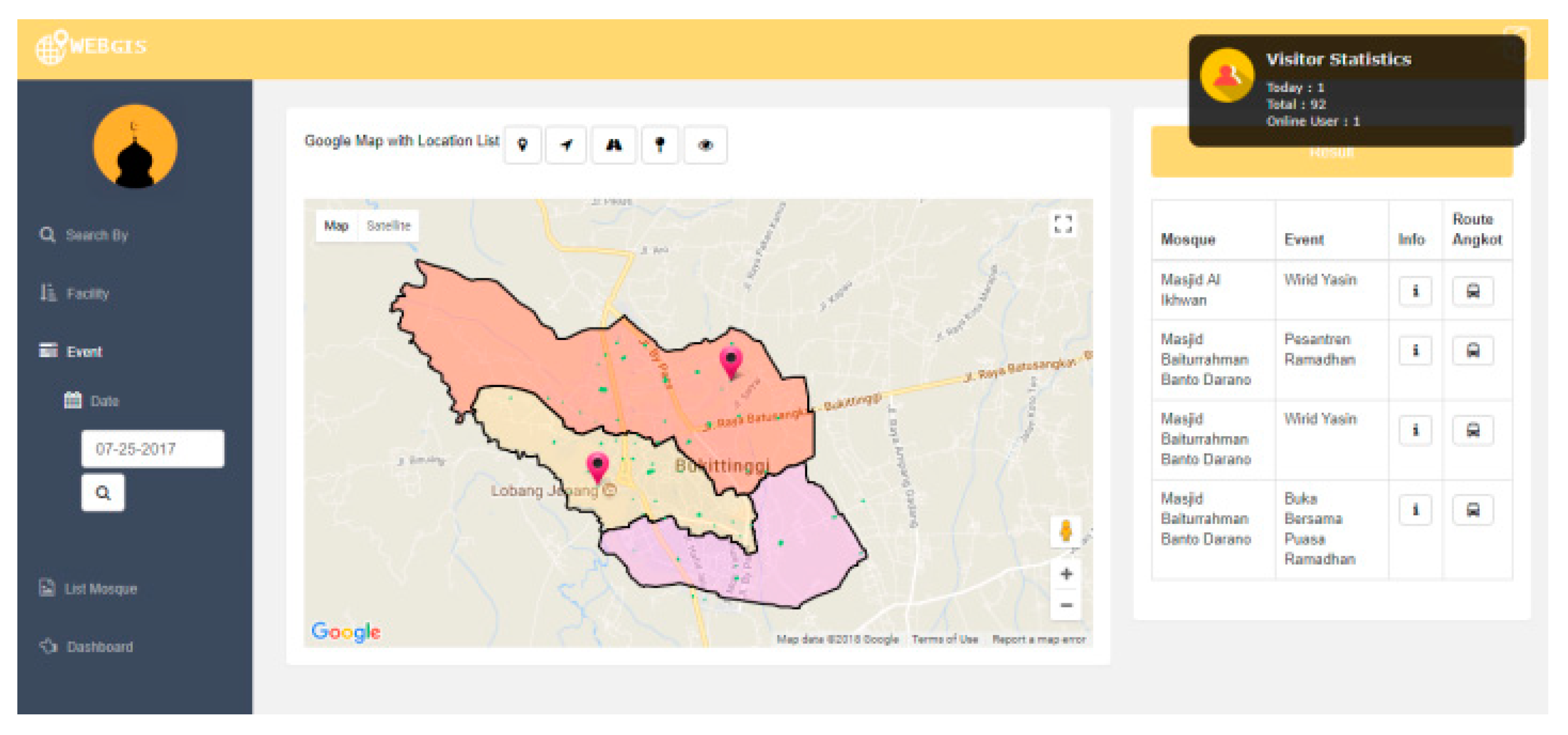
- Users should also be given information related to the activities done in the mosques including based on the name of the event and the time the event is held. The information to be displayed includes:
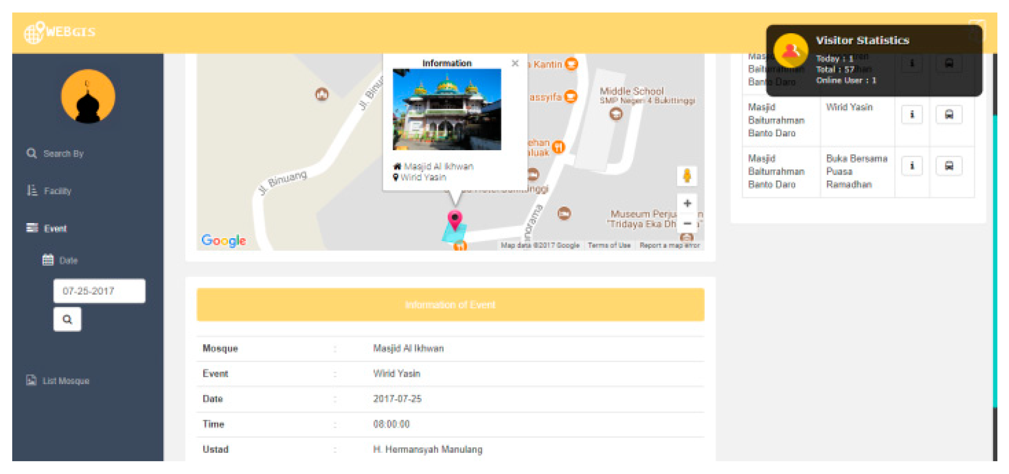
- Map of the event location.
- Detailed information: name of the event, name of the mosque, leader, data, and time of the event.
3.2. Implementation
4. Discussion
5. Conclusions
Author Contributions
Funding
Conflicts of Interest
References
- Jaelani, A. Halal tourism industry in Indonesia: Potential and prospects. IRMM 2017, 7, 25–34. [Google Scholar] [CrossRef] [Green Version]
- Suradin, M. Halal tourism promotion in Indonesia: An analysis on official destination websites. J. Ind. Tour. Dev. Stud. 2018, 6, 143–158. [Google Scholar] [CrossRef]
- Ladiqi, S.; Wardhani, B.; Wekke, I.S.; Rahim, A.F.A. Globalization and the rise of Cosmopolitan Shariah: The challenge and opportunity of Halal tourism in Indonesia. Her. NAMSCA 2018, 1, 904–907. [Google Scholar]
- Sowwam, M.; Anindita, R.D.; Riyadi, S.A.; Qibthiyyah, R.M. Kajian Dampak Sektor Pariwisata Terhadap Perekonomian Indonesia; LPEM-FEBUI: Jakarta, Indonesia, 2018; pp. 3–4. [Google Scholar]
- Afnarius, S.; Putra, H. Pengembangan Aplikasi Web GIS Pariwisata Backpacker; deePublish: Jogjakarta, Indonesia, 2017; p. 1. [Google Scholar]
- Wardi, Y.; Abror, A.; Trinanda, O. Halal tourism: Antecedent of tourist’s satisfaction and word of mouth (WOM). Asia Pac. J. Tour. Res. 2018, 23, 463–472. [Google Scholar] [CrossRef]
- Satriana, E.D.; Faridah, H.D. Halal tourism: Development, change and challenge. JHPR 2018, 1, 32–43. [Google Scholar] [CrossRef] [Green Version]
- Kamarudin, L.M.; Ismail, H.N. Muslim tourism: The tendency of islamic traveling attributes from Malaysia perspective. In Proceedings of the International Social Science and Tourism Research Conference, Terengganu, Malaysia, 20–21 April 2016. [Google Scholar]
- Andriani, D.; Khalikal, K.A.; Aqmarina, L.; Nurhayati, T. Laporan Akhir Kajian Pengembangan Wisata Syariah; Kementrian Pariwisata: Jakarta, Indonesia, 2015; p. 2. [Google Scholar]
- Budiman, M.A.; Sadewa, M.M.; Handayani, L.; Nurzaman, M.S.; Hastiadi, F.F. Opportunity and threat of developing halal tourism destinations: A Case of banjarmasin, Indonesia. IJEBO 2019, 7, 7–13. [Google Scholar] [CrossRef]
- Evolution of Muslim Traveler Faith-Based Service Needs. Available online: https://www.crescentrating.com/magazine/muslim-travel/4000/evolution-of-muslim-traveler-faith-based-service-needs.html (accessed on 24 July 2019).
- Aziz, M.A.; Ibrahim, M.; Jahnkassim, P.S.; Abdullah, A. Issues and potential of mosque as a spiritual tourism destination in Malaysia. In Proceedings of the ISER 22nd International Conference, Hong Kong, China, 13 February 2016; pp. 1–6. [Google Scholar]
- Kessler, K. Conceptualizing mosque tourism: A central feature of Islamic and religious tourism. Int. J. Relig. Tour. Pilgr. 2015, 3, 11–32. [Google Scholar] [CrossRef]
- World’s Muslim Population More Widespread Than You Might Think. Available online: https://www.pewresearch.org/fact-tank/2017/01/31/worlds-muslim-population-more-widespread-than-you-might-think/ (accessed on 24 July 2019).
- COMCEC Tourism Outlook-2018. Available online: http://www.sbb.gov.tr/wp-content/uploads/2019/06/Tourism-Outlook-2018.pdf (accessed on 7 September 2019).
- Shirazi, F. Halal and religious tourism development in Mashhad, Iran. Glob. J. Anthropol. Res. 2017, 4, 42–54. [Google Scholar] [CrossRef]
- Global Muslim Travel Index 2019. Available online: https://www.crescentrating.com/reports/global-muslim-travel-index-2019.html (accessed on 7 September 2019).
- Tarigan, Y.A.; Alfindo, O. Bukittinggi Municipality in Figures; BPS-Statistics of Bukittinggi: Bukittinggi, Indonesia, 2019; p. 47. [Google Scholar]
- Afnarius, S.; Yuliani, F.; Akbar, F. Developing mobile GIS application for religious tourism and its proponent in bukittinggi city. In Proceedings of the TDC International Conference 2019, Bukittinggi, Indonesia, 1–2 October 2019. [Google Scholar]
- Terus Berbenah, Kunjungan Wisatawan ke Bukittinggi Meningkat. Available online: https://www.dekadepos.com/2019/01/14/terus-berbenah-kunjungan-wisatawan-ke-bukittinggi-meningkat/ (accessed on 7 September 2019).
- Disbudpar Ingin Wisatawan Belanja dan Tinggal Lebih Lama di Bandung. Available online: https://www.inilahkoran.com/berita/9148/disbudpar-ingin-wisatawan-belanja-dan-tinggal-lebih-lama-di-bandung (accessed on 7 September 2019).
- Chanin, O.; Sriprasert, P.; Rahman, H.A.; Don, M.S. Guidelines on Halal tourism management in the andaman sea coast of Thailand. JOEBM 2015, 3, 791–794. [Google Scholar] [CrossRef] [Green Version]
- Hassan, Z. Factors affecting Muslim Tourists choice of Halal concept hotels and satisfaction in Malaysia: Moderating effect of Religious Devotedness. IJABM 2015, 3, 133–143. [Google Scholar] [CrossRef]
- Sriprasert, P.; Chainin, O.; Abd Rahman, H. Understanding behavior and needs of Halal tourism in andaman gulf of Thailand: A case of asian muslim. JOAMS 2014, 2, 216–219. [Google Scholar] [CrossRef]
- Rifki, M.; Rahmafitria, F.; Sugito, N.T. Tourism component evaluation: GIS based analysis towards the qualification of destination planning. Adv. Soc. Sci. Educ. Humanit. Res. 2018, 259, 121–124. [Google Scholar]
- Gu, Z.; Zhang, Y.; Chen, Y.; Chang, X. Analysis of attraction features of tourism destinations in a mega-city based on check-in data mining—A case study of Shenzhen, China. ISPRS Int. J. Geo Inf. 2016, 5, 210. [Google Scholar] [CrossRef] [Green Version]
- Berhanu, M.; Raghuvanshi, T.K.; Suryabhagavan, K.V. Web-based GIS approach for tourism development in addis ababa city, Ethiopia. MJRSGIS 2017, 6, 13–25. [Google Scholar]
- Afnarius, S.; Dinata, U.G.S.; Ichwana, D.; Akbar, F. Web GIS development for Minangkabau customary village: A case study of Padang Lua Village, West Sumatra, Indonesia. IJG 2017, 13, 1–12. [Google Scholar]
- Darman, R.; Afnarius, S. Developing WebGIS for buildings in Koto Gadang, Agam Regency, West Sumatra Province. In Proceedings of the International Conference on ASEAN 2019, Padang, Indonesia, 5–6 September 2019. [Google Scholar]
- Marizka, M.; Afnarius, S. Development of Web and mobile GIS application of disaster in Padang to support tourism of West Sumatra Province. In Proceedings of the International Conference on ASEAN 2019, Padang, Indonesia, 5–6 September 2019. [Google Scholar]
- Pressman, R.S. Rekayasa Perangkat Lunak (Pendekatan. Praktisi), 7th ed.; Andi: Yogyakarta, Indonesia, 2012. [Google Scholar]
- Bartoszewski, D.; Piorkowski, A.; Lupa, M. The Comparison of Processing Efficiency of Spatial Data for PostGIS and MongoDB Databases; BDAS 2019; Springer: Cham, Germany, 2019; pp. 291–302. [Google Scholar] [CrossRef]
- Gong, X.; Erwee, F.; Rautenbach, V. Geometry viewer for pgadmin4: A process guided by the google summer of code. In Proceedings of the International Archives of the Photogrammetry, Remote Sensing and Spatial Information Sciences XLII-4/W14, Bucharest, Romania, 26–30 August 2019; pp. 79–83. [Google Scholar] [CrossRef] [Green Version]
- Vaisman, A.; Zimányi, E. Mobility datawarehouses. ISPRS Int. J. Geo Inf. 2019, 8, 170. [Google Scholar] [CrossRef] [Green Version]
- Lizardo, L.E.O.; Davis, C.A., Jr. A PostGIS extension to support advanced spatial data types and integrity constraints. In Proceedings of the SIGSPATIAL’17, Los Angeles Area, CA, USA, 7–10 November 2017. [Google Scholar] [CrossRef]
- Singh, S.P.; Singh, P. Modeling a geo-spatial database for managing travelers’ demand. IJDMS 2014, 6, 39–47. [Google Scholar] [CrossRef]
- Shukla, D.; Chirag Shivnani, C.; Shah, D. Comparing oracle spatial and postgres PostGIS. IJCSE 2016, 7, 95–100. [Google Scholar]
- Makris, A.; Tserpes, K.; Spiliopoulos, G.; Anagnostopoulos, D. Performance evaluation of MongoDB and PostgreSQL for spatio-temporal data. In Proceedings of the 2nd International Workshop on Big Mobility Data Analytics, Lisbon, Portugal, 26–29 March 2019. [Google Scholar]
- Sveen, A.F. Efficient storage of heterogeneous geospatial data in spatial databases. J. Big Data 2019, 6, 102. [Google Scholar] [CrossRef]
- Abdullah, N.F.; Radzi, R.N.M.; Abu Bakar, S.Z. Visitor interpretation and Islamic tourism focusing at mosque. In Proceedings of the 1st International Conference on Religion, Social Sciences and Technological Education, Nilai, Malaysia, 25–26 September 2018; pp. 226–231. [Google Scholar]
- Azmi, E.; Ismail, M.Z. Cultural heritage tourism: Kapitan Keling mosque as a focal point & symbolic identity for Indian muslim in Penang. Procedia Soc. Behav. Sci. 2016, 222, 528–538. [Google Scholar] [CrossRef] [Green Version]
- Le-Klahn, D.T.; Gerike, R.; Hall, C.M. Visitor users vs. Non-users of public transport: The case of Munich, Germany. JDMM 2014, 3, 152–161. [Google Scholar] [CrossRef] [Green Version]
- Kantawateera, K.; Naipinit, A.; Sakolnakorn, T.P.N.; Kroeksakul, P. Tourist transportation problems and guidelines for developing the tourism industry in Khon Kaen, Thailand. ASS 2015, 11, 89–95. [Google Scholar] [CrossRef] [Green Version]


| id | Worship_Place_Name | Address | Capacity | Land Size | Park Area Size | Building Size | est | Last Renovation | Jamaah | Imam | Teenager | Fasilitas | lng | lat |
|---|---|---|---|---|---|---|---|---|---|---|---|---|---|---|
| M0001 | Masjid Darussalam Gurun Panjang | Jl. Gurun Panjang, Pakan Kurai | 145 | 510 | 78 | 377 | 1964 | 2001 | 50 | 2 | 15 | Al Quran, Bathroom, Mukena, Park Area, Paud, Place of Wudhu, Sarong | 100.37715 | −0.30489614 |
| M0002 | Masjid Jamik Aur Kuning | Jl. Moh. Yamin, Tarok Dipo, Guguk Panjang | 725 | 3800 | 220 | 1561 | 1961 | 2017 | 150 | 1 | 15 | Shoe Storage Area, Bathroom, Place of Wudhu | 100.385677 | −0.32127068 |
| M0003 | Masjid Baburrahmah | Jalan Veteran No. 229, Luak Anyir, Kubu Gulai Bancah | 185 | 1300 | 450 | 420 | - | - | 150 | 1 | 15 | Bathroom, Body Treatment Equip, Mimbar, Mukena, Park Area, Place of Wudhu, Shoe Racks/Sandals | 100.365611 | −0.28706166 |
| M0004 | Masjid Al Furqan | Jl. Abdul Manan, Campago Ipuh | 165 | 1950 | 300 | 1271 | - | - | 150 | 1 | 15 | Body Treatment Equip, Place of Wudhu | 100.379666 | −0.28968646 |
| M0005 | Masjid Mukhlisin | Jl. Sukarno Hatta, Garegeh | 575 | 2750 | 126 | 1270 | - | 2017 | 150 | 1 | 15 | Park Area, Place of Wudhu | 100.38149 | −0.2975884 |
| M0006 | Masjid Jamik Birugo | Jl. Sudirman, Birugo, Aur Birugo Tigo Baleh | 800 | 2430 | 537 | 816 | 1956 | - | 100 | 2 | 40 | Al Quran, Bathroom, Body Treatment Equip, Cap, Mukena, Park Area, Place of Wudhu, Sarong, Warehouse | 100.376731 | −0.31833827 |
| M0007 | Masjid Syukra | Jl. Ipuh Mandiangin, Campago Ipuh | 275 | 1015 | 232 | 603 | - | - | 150 | 1 | 15 | Al Quran, Bathroom, Body Treatment Equip, Mukena, Park Area, Place of Wudhu | 100.374731 | −0.29725673 |
| Field Name | Data Type | Description |
|---|---|---|
| id | Varchar (5) | Primary Key |
| name | Varchar (25) | |
| address | Varchar (50) | |
| land_size | Integer | The land area of worship |
| park_area_size | Integer | Parking area |
| building_size | Integer | Building area of worship place |
| capacity | Integer | Congregational capacity |
| est | Integer | Year of building |
| last_renovation | Integer | The last renovation year |
| jamaah | Integer | Number of active worshipers |
| imam | Integer | Number of priests |
| teenager | Integer | The number of mosque youth |
| id_category | Integer | Foreign Key |
| geom | Geometry | The coordinates of places of worship |
| Use Case | Search for Places of Worship around the User’s Position |
|---|---|
| Participating Actor | User |
| Flow of Event | 1. The user selects the nearby button 2. The system displays the seek bar input form 3. The user selects the radius by sliding the seek bar left or right 4. The system displays the position and place of worship information |
| Entry Condition | The user has opened the application |
| Exit Condition | The user gets the position as well as information on all places of worship around the user’s position |
© 2020 by the authors. Licensee MDPI, Basel, Switzerland. This article is an open access article distributed under the terms and conditions of the Creative Commons Attribution (CC BY) license (http://creativecommons.org/licenses/by/4.0/).
Share and Cite
Afnarius, S.; Akbar, F.; Yuliani, F. Developing Web-Based and Mobile-Based GIS for Places of Worship Information to Support Halal Tourism: A Case Study in Bukittinggi, Indonesia. ISPRS Int. J. Geo-Inf. 2020, 9, 52. https://0-doi-org.brum.beds.ac.uk/10.3390/ijgi9010052
Afnarius S, Akbar F, Yuliani F. Developing Web-Based and Mobile-Based GIS for Places of Worship Information to Support Halal Tourism: A Case Study in Bukittinggi, Indonesia. ISPRS International Journal of Geo-Information. 2020; 9(1):52. https://0-doi-org.brum.beds.ac.uk/10.3390/ijgi9010052
Chicago/Turabian StyleAfnarius, Surya, Fajril Akbar, and Fitri Yuliani. 2020. "Developing Web-Based and Mobile-Based GIS for Places of Worship Information to Support Halal Tourism: A Case Study in Bukittinggi, Indonesia" ISPRS International Journal of Geo-Information 9, no. 1: 52. https://0-doi-org.brum.beds.ac.uk/10.3390/ijgi9010052