Dynamics of Sediments in Reservoir Inflows: A Case Study of the Skalka and Nechranice Reservoirs, Czech Republic


Abstract
:1. Introduction
2. Methodology
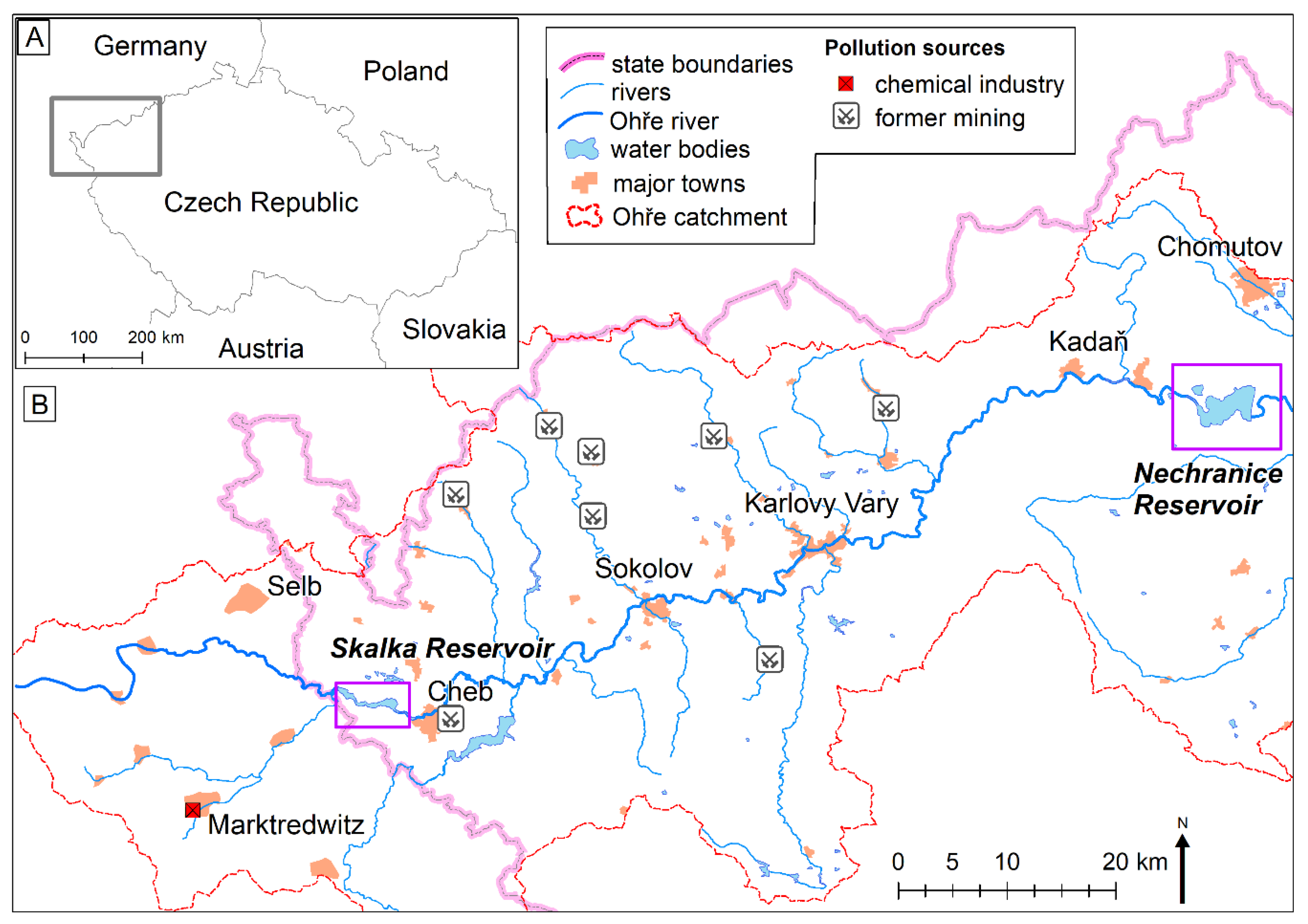
2.1. Study Area
2.2. Pre-Dam Topography Derived from Archival Aerial Photographs
2.3. Pre-Dam Topography Derived from Old Maps
2.4. Reservoir Bottom Topography
2.4.1. Sonar Survey
2.4.2. GPR and Sub-Bottom Profiler
2.4.3. Photogrammetric Survey in the Nechranice Reservoir
2.4.4. LiDAR Survey in Skalka Reservoir
2.5. Quality of Input Data and Survey Methods
3. Results
3.1. Precision of Modeling the Pre-Dam Topography
3.2. Precision of Modeling the Reservoir Bottom Topography
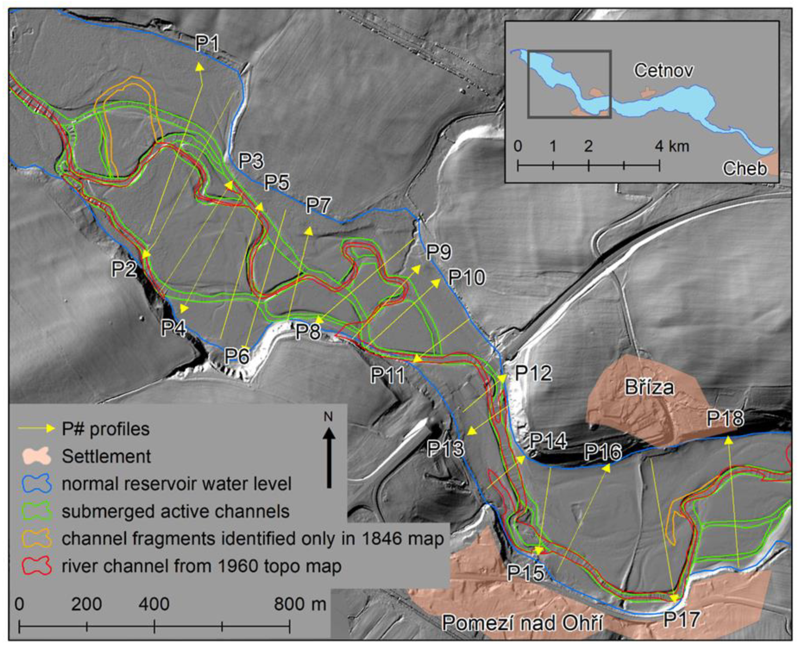
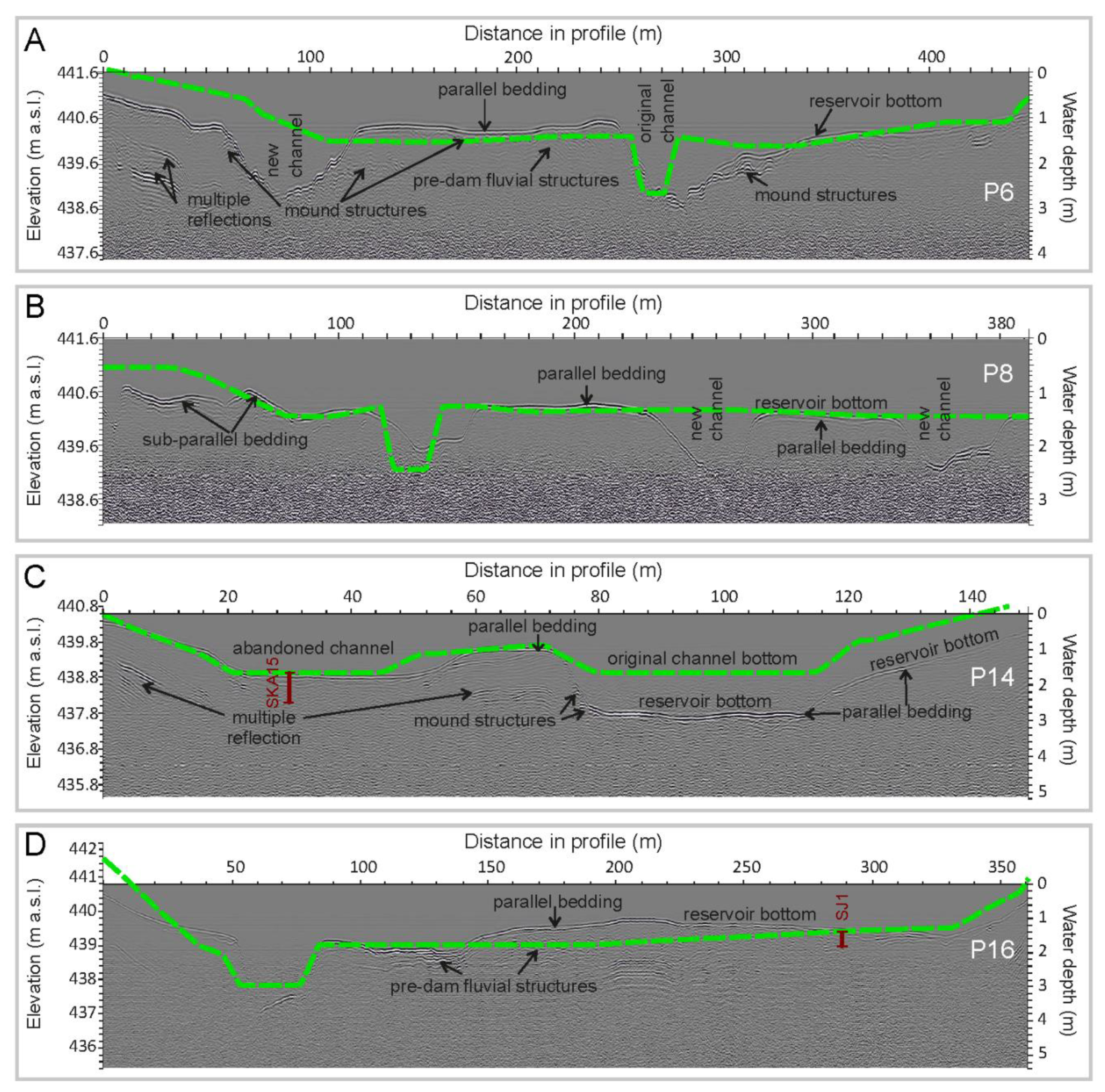
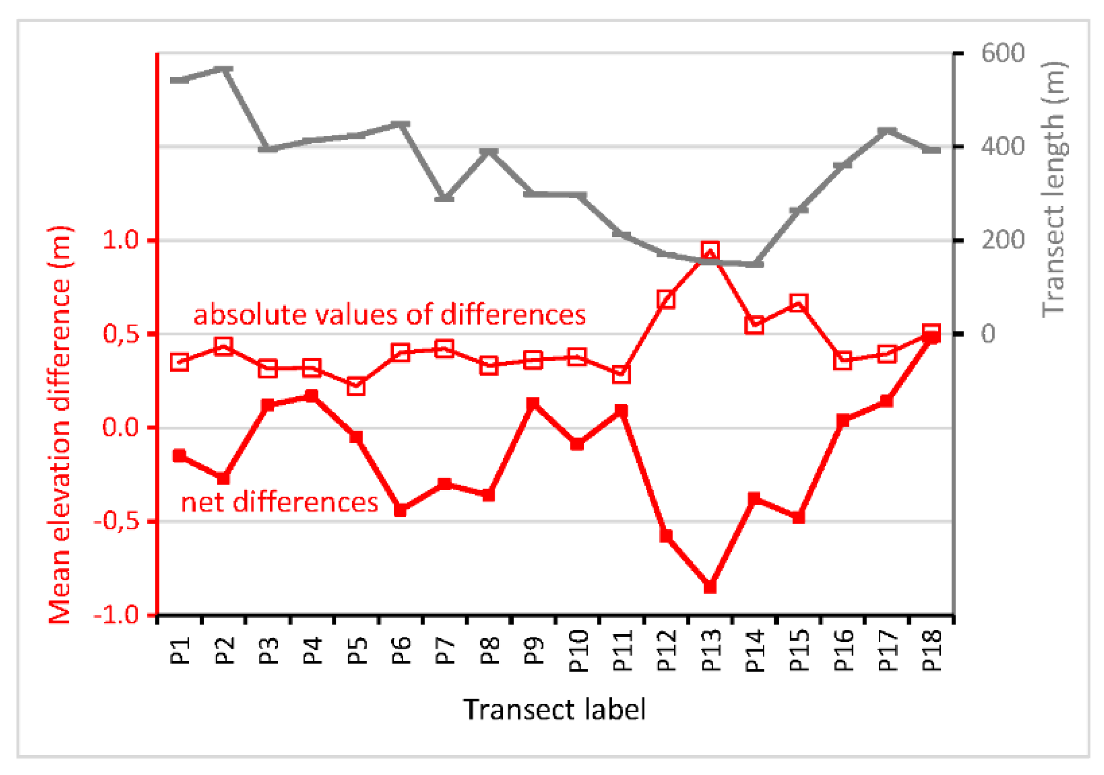
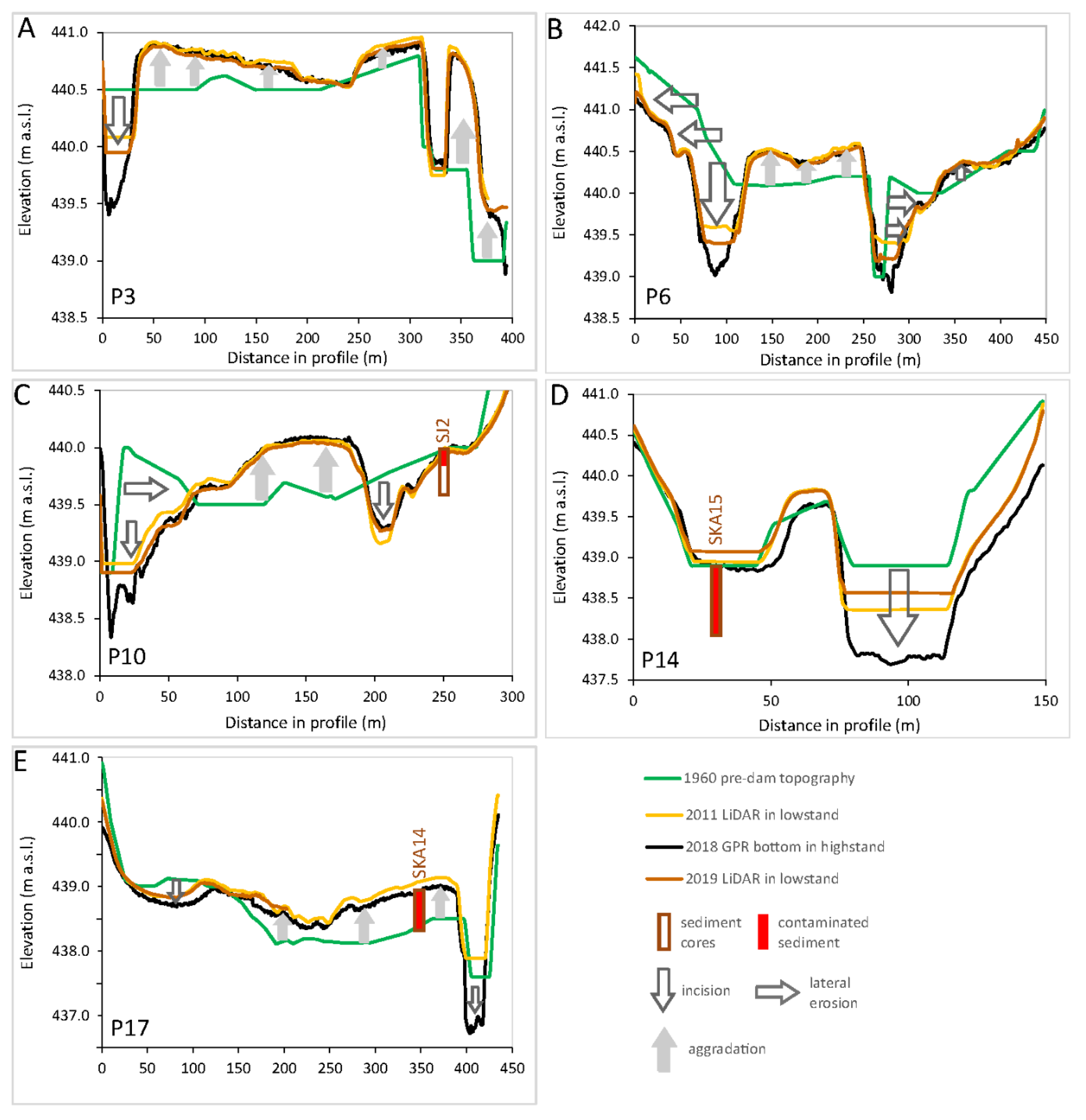
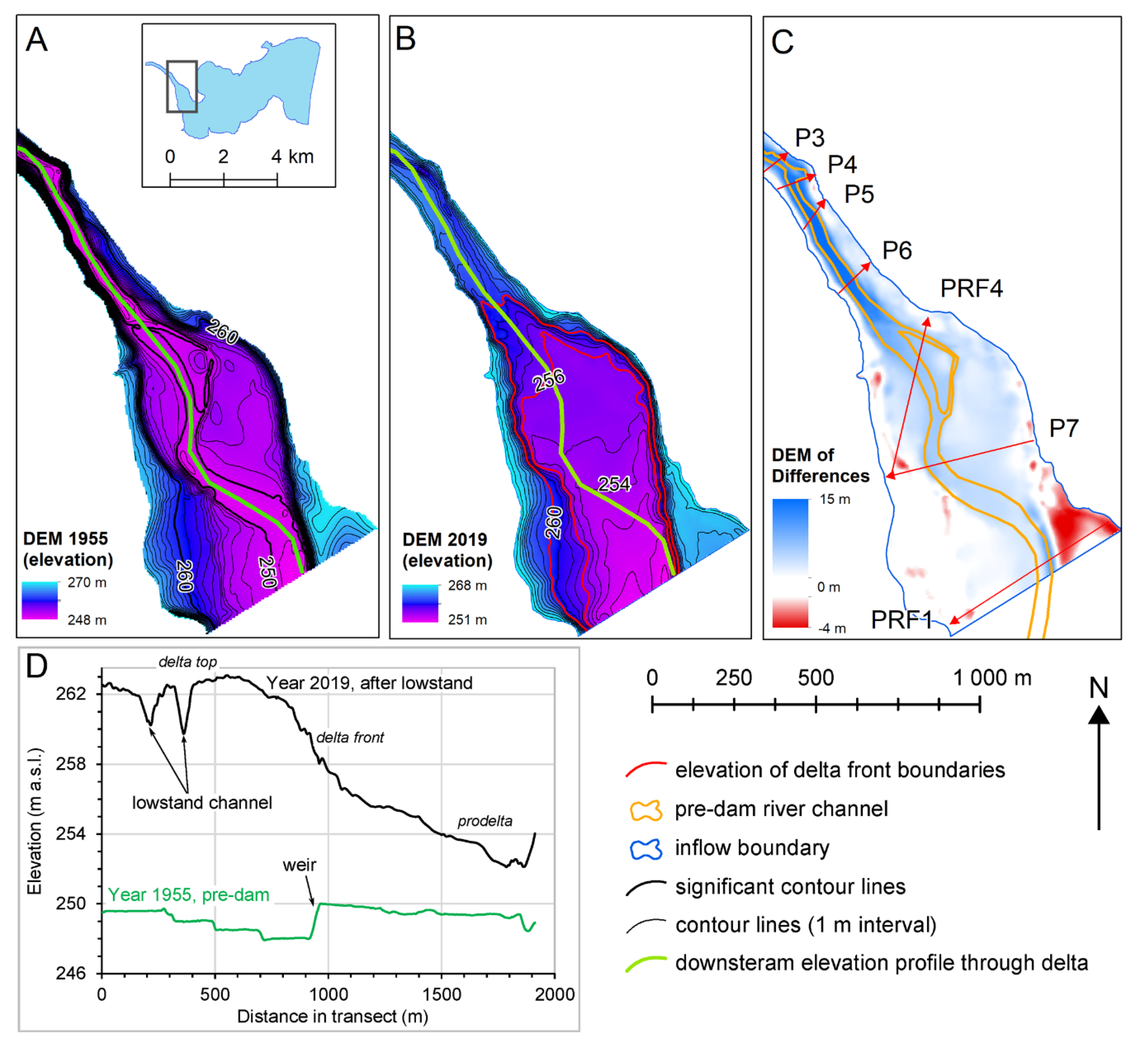
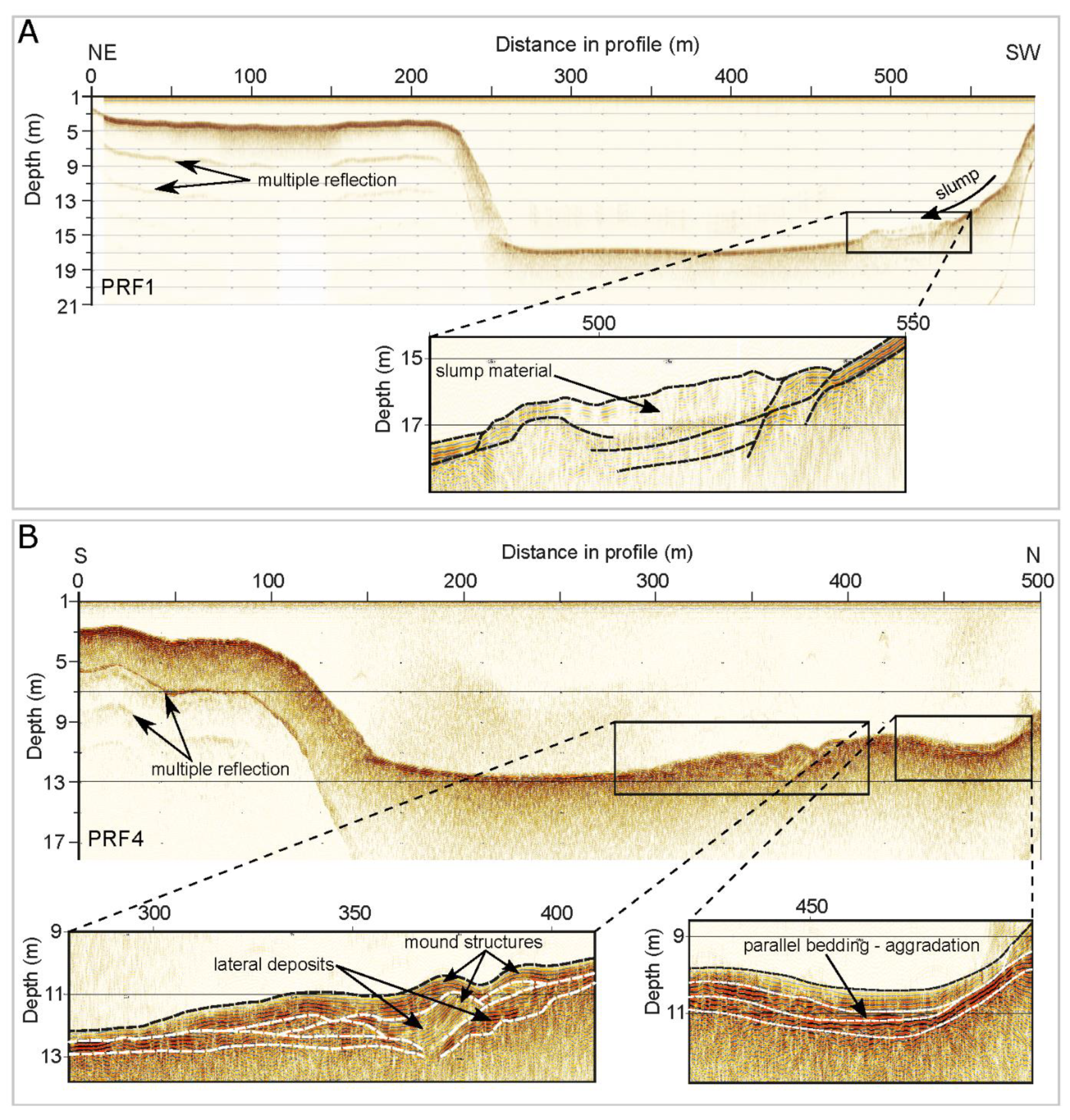
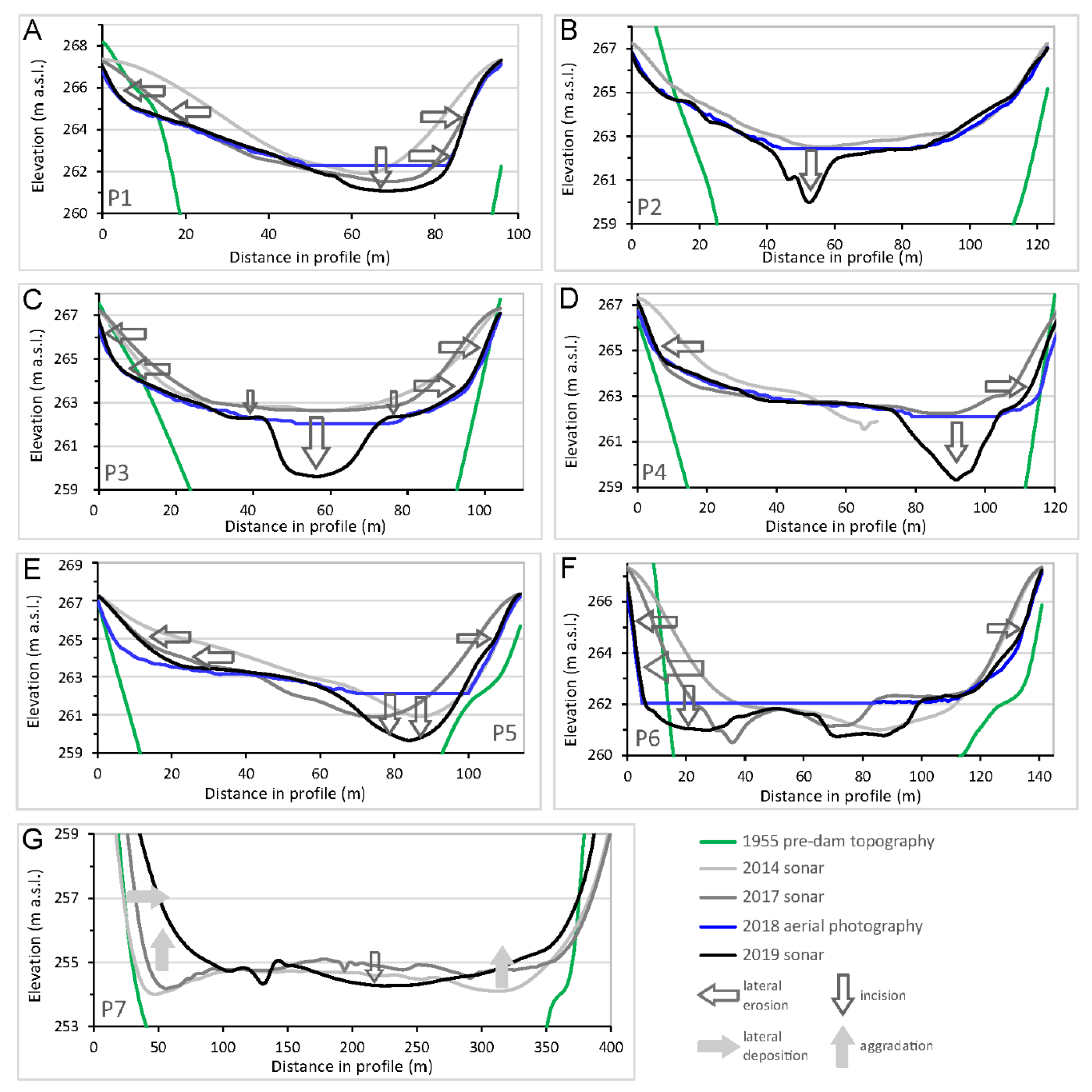
3.3. Inflow to Skalka Reservoir
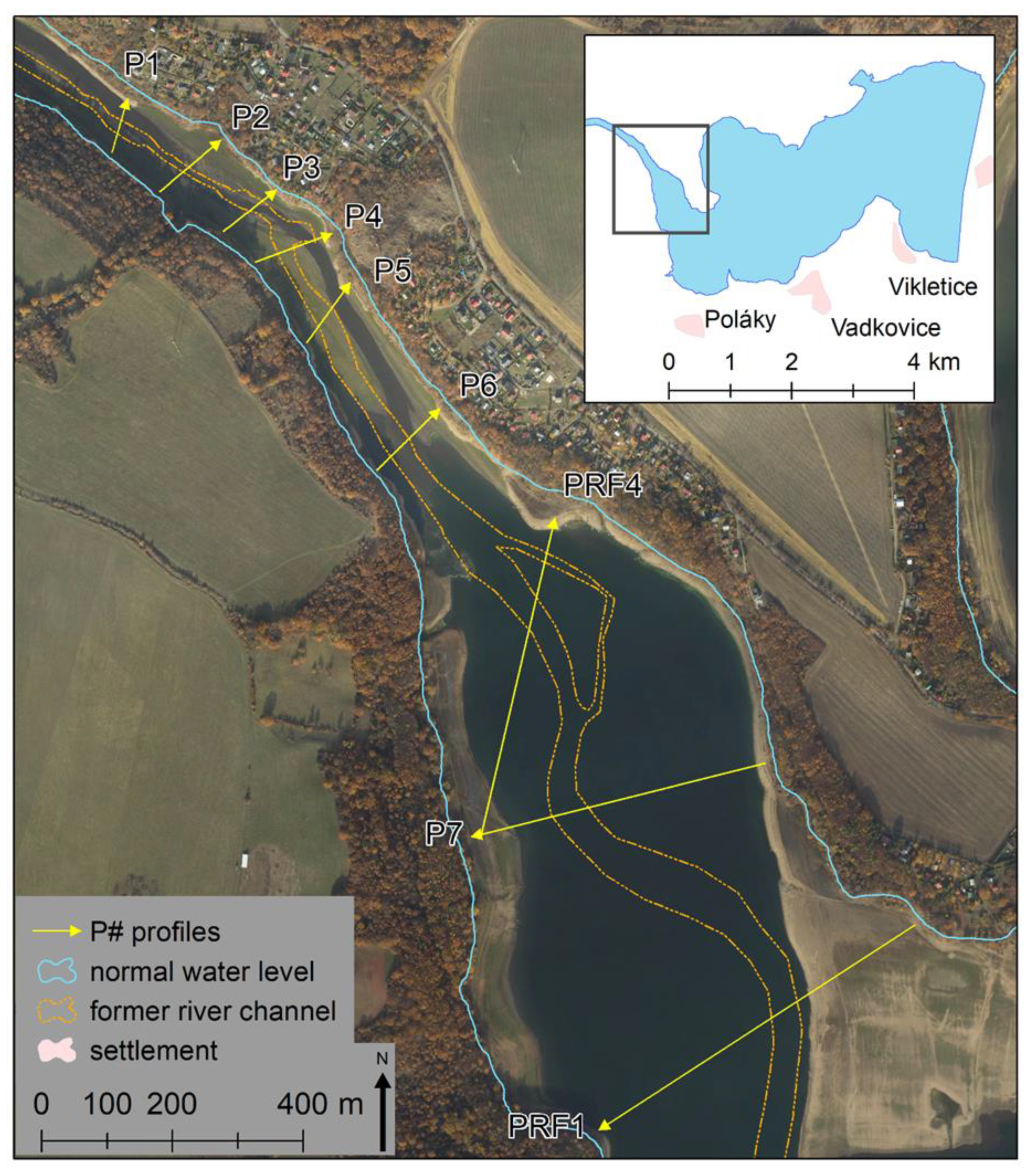
3.4. Inflow to Nechranice Reservoir
4. Discussion
4.1. Data Quality, Evaluation of Routines/Techniques, and Verification of Results
4.2. Inflow Sediment Dynamics
5. Conclusions
Author Contributions
Funding
Conflicts of Interest
Appendix A
References
- Schleiss, A.J.; Franca, M.J.; Juez, C.; De Cesare, G. Reservoir sedimentation. J. Hydraul. Res. 2016, 54, 595–614. [Google Scholar] [CrossRef]
- Chen, J.; Zhou, W.; Han, S.; Sun, G. Influences of retrogressive erosion of reservoir on sedimentation of its downstream river channel—A case study on Sanmenxia Reservoir and the Lower Yellow River. Int. J. Sediment Res. 2017, 32, 373–383. [Google Scholar] [CrossRef]
- Rahmani, V.; Kastens, J.H.; de Noyelles, F.; Jakubauskas, M.E.; Martinko, E.A.; Huggins, D.H.; Gnau, C.; Liechti, P.M.; Campbell, S.W.; Callihan, R.A.; et al. Examining Storage Capacity Loss and Sedimentation Rate of Large Reservoirs in the Central U.S. Great Plains. Water 2018, 10, 190. [Google Scholar] [CrossRef] [Green Version]
- Bábek, O.; Kielar, O.; Lenďáková, Z.; Mandlíková, K.; Sedláček, J.; Tolaszová, J. Reservoir deltas and their role in pollutant distribution in valley-type dam reservoirs: Les Království Dam, Elbe River, Czech Republic. Catena 2020, 184, 104251. [Google Scholar] [CrossRef]
- Frémion, F.; Courtin-Nomade, A.; Bordas, F.; Lenain, J.-F.; Jugé, P.; Kestens, T.; Mourier, B. Impact of sediments resuspension on metal solubilization and water quality during recurrent reservoir sluicing management. Sci. Total Environ. 2016, 562, 201–215. [Google Scholar] [CrossRef]
- Majerová, L.; Bábek, O.; Navrátil, T.; Nováková, T.; Štojdl, J.; Elznicová, J.; Hron, K.; Matys Grygar, T. Dam reservoirs as an efficient trap for historical pollution: The passage of Hg and Pb through the Ohře River, Czech Republic. Environ. Earth Sci. 2018, 77, 574. [Google Scholar] [CrossRef]
- Chassiot, L.; Francus, P.; De Coninck, A.; Lajeunesse, P.; Cloutier, D.; Labarre, T. Spatial and temporal patterns of metallic pollution in Québec City, Canada: Sources and hazard assessment from reservoir sediment records. Sci. Total Environ. 2019, 673, 136–147. [Google Scholar] [CrossRef]
- Matys Grygar, T.; Bábek, O.; Sedláček, J.; Lenďáková, Z.; Faměra, M.; Štojdl, J.; Pacina, J.; Tolaszová, J.; Kříženecká, S. Segregation and Retention of As, Potentially Toxic Metals, and Organic Pollutants in a Reservoir from the Ohře River (the Czech Republic). J. Soils Sediments 2020. in print. [Google Scholar]
- Palinkas, C.M.; Russ, E. Spatial and temporal patterns of sedimentation in an infilling reservoir. Catena 2019, 180, 120–131. [Google Scholar] [CrossRef]
- Lachhab, A.; Booterbaugh, A.; Beren, M. Bathymetry and Sediment Accumulation of Walker Lake, PA Using Two GPR Antennas in a New Integrated Method. J. Environ. Eng. Geophys. 2015, 20, 245–255. [Google Scholar] [CrossRef] [Green Version]
- Łajczak, A. Modelling the long-term course of non-flushed reservoir sedimentation and estimating the life of dams. Earth Surf. Process. Landf. 1996, 21, 1091–1107. [Google Scholar] [CrossRef]
- Brasington, J.; Langham, J.; Rumsby, B. Methodological sensitivity of morphometric estimates of coarse fluvial sediment transport. Geomorphology 2003, 53, 299–316. [Google Scholar] [CrossRef]
- James, A.L.; Hodgson, M.E.; Ghoshal, S.; Latiolais, M.M. Geomorphic change detection using historic maps and DEM differencing: The temporal dimension of geospatial analysis. Geomorphology 2012, 137, 181–198. [Google Scholar] [CrossRef]
- Lane, S.N.; Westaway, R.M.; Hicks, M. Estimation of erosion and deposition volumes in a large, gravel-bed, braided river using synoptic remote sensing. Earth Surf. Process. Landf. 2003, 28, 249–271. [Google Scholar] [CrossRef]
- Brůna, V.; Pacina, J.; Pacina, J.; Vajsová, E. Modelling the extinct landscape and settlement for preservation of cultural heritage. Città Storia. 2014, 9, 131–153, ISSN 1828-6364. [Google Scholar]
- Pacina, J.; Novák, K.; Popelka, J. Georelief transfiguration in areas affected by open-cast mining. Trans. GIS 2012, 16, 663–679, ISSN 1361-1682. [Google Scholar] [CrossRef]
- Skaloš, J.; Weber, M.; Lipský, Z.; Trpáková, I.; Šantrůčková, M.; Uhlířová, L.; Kukla, P. Using old military survey maps and orthophotograph maps to analyse long-term land cover changes. Case study (Czech Republic). Appl. Geogr. 2011, 31, 426–438. [Google Scholar] [CrossRef]
- Vuorela, N.; Alho, P.; Kalliola, R. Systematic assessment of maps as source information in Landscape-change research. Landsc. Res. 2002, 27, 141–166. [Google Scholar] [CrossRef]
- Pandey, A.C.; Kumar, A. Analysing topographical changes in open cast coal-mining region of Patratu, Jharkhand using CARTOSAT-I Stereopair satellite images. Geocarto Int. 2014, 29, 731–744. [Google Scholar] [CrossRef]
- Jaskulski, M.; Nowak, T. Transformations of Landscape Topography of the Bełchatów Coal Mine (Central Poland) and the Surrounding Area Based on DEM Analysis. Isprs Int. J. Geo-Inf. 2019, 8, 403. [Google Scholar] [CrossRef] [Green Version]
- Hughes, M.L.; McDowell, P.F.; Marcus, W.A. Accuracy assessment of georectified aerial photos: Implications for measuring lateral channel movement in a GIS. Geomorphology 2006, 74, 1–16. [Google Scholar] [CrossRef]
- Pulighe, G.; Fava, F. DEM extraction from archive aerial photos: Accuracy assessment in areas of complex topography. Eur. J. Remote Sens. 2013, 46, 363–378. [Google Scholar] [CrossRef] [Green Version]
- Sevara, C.; Verhoeven, G.; Doneus, M.; Draganits, E. Surfaces from the Visual Past: Recovering High-Resolution Terrain Data from Historic Aerial Imagery for Multitemporal Landscape Analysis. J. Archaeol. Method Theory 2017, 25, 611–642. [Google Scholar] [CrossRef] [PubMed] [Green Version]
- Clark, A.J.; Casana, J. A new use for old photos: Archaeological landscape reconstruction in the Big Bend. Plains Anthropol. 2016, 61, 469–489. [Google Scholar] [CrossRef]
- Bangen, S.G.; Wheaton, J.M.; Bouwes, N.; Bouwes, B.; Jordan, C. A methodological intercomparison of topographic survey techniques for characterizing wadeable streams and rivers. Geomorphology 2014, 206, 343–361, ISSN 0169-555X. [Google Scholar] [CrossRef]
- Popielarczyk, D.; Templin, T.; Łopata, M. Using the geodetic and hydroacoustic measurements to investigate the bathymetric and morphometric parameters of Lake Hancza (Poland). Open Geosci. 2015, 7, 854–869. [Google Scholar]
- Heritage, G.L.; Milan, D.; Large, A.R.G.; Fuller, I.C. Influence of survey strategy and interpolation model on DEM quality. Geomorphology 2009, 112, 334–344, ISSN 0169-555X. [Google Scholar] [CrossRef]
- Theberge, A.E., Jr.; Dierssen, H.M. Bathymetry: Assessing Methods. In Encyclopedia of Natural Resources. Volume II—Water and Air; Wang, Y., Ed.; Taylor & Francis Group: Abingdon, UK, 2014; Volume 2, ISBN 9781439852484. [Google Scholar]
- Yeu, Y.; Yee, J.-J.; Yun, H.S.; Kim, K.B. Evaluation of the Accuracy of Bathymetry on the Nearshore Coastlines of Western Korea from Satellite Altimetry, Multi-Beam, and Airborne Bathymetric LiDAR. Sensors 2018, 18, 2926. [Google Scholar] [CrossRef] [Green Version]
- Allouis, T.; Bailly, J.S.; Pastol, Y.; Le Roux, C. Comparison of LiDAR waveform processing methods for very shallow water bathymetry using Raman, near-infrared and green signals. Earth Surf. Process. Landf. 2010, 35, 640–650. [Google Scholar] [CrossRef]
- Marcus, W.A. Remote sensing of the hydraulic environment in gravel-bed rivers. In Gravel-Bed Rivers: Processes, Tools, Environments; Church, M., Biron, P.M., Roy, A.G., Eds.; John Wiley & Sons, Ltd.: Chichester, UK, 2012; pp. 259–285. [Google Scholar]
- Banks, W.S.; Johnson, C.D. Collection, Processing, and Interpretation of Ground-Penetrating Radar Data to Determine Sediment Thickness at Selected Locations in Deep Creek Lake, Garrett County, Maryland, 2007; US Department of the Interior, US Geological Survey: Washington, DC, USA, 2011.
- Mihu-Pintilie, A.; Asandulesei, A.; Nicu, I.C.; Stoleriu, C.C.; Romanescu, G. Using GPR for assessing the volume of sediments from the largest natural dam lake of the Eastern Carpathians: Cuejdel Lake, Romania. Environ. Earth Sci. 2016, 75, 710. [Google Scholar] [CrossRef]
- Sass, O.; Krautblatter, M.; Morche, D. Rapid lake infill following major rockfall (bergsturz) events revealed by ground-penetrating radar (GPR) measurements, Reintal, German Alps. Holocene 2007, 17, 965–976. [Google Scholar] [CrossRef]
- Sambuelli, L.; Bava, S. Case study: A GPR survey on a morainic lake in northern Italy for bathymetry, water volume and sediment characterization. J. Appl. Geophys. 2012, 81, 48–56. [Google Scholar] [CrossRef] [Green Version]
- Nakamura, K.; Machida, S.; Okino, K.; Masaki, Y.; Iijima, K.; Suzuki, K.; Kato, Y. Acoustic characterization of pelagic sediments using sub-bottom profiler data: Implications for the distribution of REY-rich mud in the Minamitorishima EEZ, western Pacific. Geochem. J. 2016, 50, 605–619. [Google Scholar] [CrossRef] [Green Version]
- Schrottke, K.; Becker, M.; Bartholomä, A.; Flemming, B.W.; Hebbeln, D. Fluid mud dynamics in the Weser estuary turbidity zone tracked by high-resolution side-scan sonar and parametric sub-bottom profiler. Geo-Mar. Lett. 2006, 26, 185–198. [Google Scholar] [CrossRef]
- Saleh, M.; Rabah, M. Seabed sub-bottom sediment classification using parametric sub-bottom profiler. NRIAG J. Astron. Geophys. 2016, 5, 87–95. [Google Scholar] [CrossRef] [Green Version]
- Alotaibi, A.M.; Nwokebuihe, S.; Torgashov, E.; Elkrry, A.; Anderson, N. Characterizing Lake Bottom Sediments Using Marine Geophysical Tools. Int. J. Geosci. 2019, 10, 328–350. [Google Scholar] [CrossRef] [Green Version]
- Lafferty, B.; Quinn, R.; Breen, C. A side-scan sonar and high-resolution Chirp sub-bottom profile study of the natural and anthropogenic sedimentary record of Lower Lough Erne, northwestern Ireland. J. Archaeol. Sci. 2006, 33, 756–766. [Google Scholar] [CrossRef]
- Matys Grygar, T.; Elznicová, J.; Kiss, T.; Smith, H.G. Using sedimentary archives to reconstruct pollution history and sediment provenance: The Ohře River, Czech Republic. Catena 2016, 144, 109–129. [Google Scholar] [CrossRef]
- Hošek, M.; Bednárek, J.; Popelka, J.; Elznicová, J.; Tůmová, Š.; Rohovec, J.; Navrátil, T.; Matys Grygar, T. Persistent mercury hot spot in Central Europe and Skalka Dam reservoir as a long-term mercury trap. Environ. Geochem. Health 2019, in press. [Google Scholar]
- Liro, M. Development of sediment slug upstream from the Czorsztyn Reservoir (southern Poland) and its interaction with river morphology. Geomorphology 2016, 253, 225–238. [Google Scholar] [CrossRef]
- Matys Grygar, T.; Hošek, M.; Pacina, J.; Štojdl, J.; Bábek, O.; Sedláček, J.; Hron, K.; Talská, R.; Kříženecká, S.; Tolaszová, J. Changes in the geochemistry of fluvial sediments after dam construction (the Chrudimka River, the Czech Republic). Appl. Geochem. 2018, 98, 94–108, ISSN 0883-2927. [Google Scholar] [CrossRef]
- Cowley, D.C.; Standring, R.; Abicht, M. (Eds.) Landscapes through the Lens: Aerial Photographs and Historic Environment; Oxbow Books: Oxford, UK, 2010. [Google Scholar]
- Cantoro, G. Aerial Reconnaissance in Archaeology—From Archives to Digital Photogrammetry. In Best Practices of GeoInformatic Technologies for the Mapping of Archaeolandscapes; Sarris, A., Ed.; Archaeopress Publishing Ltd.: Oxford, UK, 2015; ISBN 978-1-78491-162-1. [Google Scholar]
- Milan, D.J.; Heritage, G.L.; Large, A.R.G.; Fuller, I.C. Filtering spatial error from DEMs: Implications for morphological change estimation. Geomorphology 2011, 125, 160–171, ISSN 0169-555X. [Google Scholar] [CrossRef]
- International Hydrographic Organization—IHO Standards for Hydrographic Surveys, 5th ed.; Available online: https://iho.int/uploads/user/pubs/standards/s-44/S-44_5E.pdf (accessed on 31 March 2020).
- Milsom, J. Field Geophysics (Geological Field Guide Book 25), 3rd ed.; John Wiley & Sons: Chichester, UK, 2003; Volume 169. [Google Scholar]
- Daniels, D.J. (Ed.) Ground Penetrating Radar, 2nd ed.; The Institution of Electrical Engineers: London, UK, 2004; p. 75. [Google Scholar]
- ČÚZK—Geoportal. Digital Terrain Model of the Czech Republic of the 5th Generation. Available online: https://bit.ly/39LZw9Q (accessed on 8 January 2020).
- Saylam, K.; Hupp, J.R.; Averett, A.R.; Gutelius, W.F.; Gelhar, B.W. Airborne lidar bathymetry: Assessing quality assurance and qualitycontrol methods with Leica Chiroptera examples. Int. J. Remote Sens. 2018, 39, 2518–2542. [Google Scholar] [CrossRef]
- Pacina, J.; Sládek, J. Observing Landscape Changes Using Distant Methods. Civ. Eng. J. 2015, 1, 1–11. [Google Scholar] [CrossRef]
- Łajczak, A. Deltas in Dam-Retained Lakes in the Carpathian Part of the Vistula Drainage Basin. Prace Geograficzne 2006, 116, 99–109. [Google Scholar]
- Pacina, J.; Štojdl, J.; Lenďáková, Z.; Matys Grygar, T.; Dolejš, M. Data for: Dynamics of sediments in reservoir inflows: A case study of the Skalka and Nechranice reservoirs, Czech Republic. Mendeley Data 2020. [Google Scholar] [CrossRef]
- Shotbolt, L.A.; Thomas, A.D.; Hutchinson, S.M. The use of reservoir sediments as environmental archives of catchment inputs and atmospheric pollution. Prog. Phys. Geogr. 2005, 29, 337–361. [Google Scholar] [CrossRef]
- Liro, M. Dam-induced base-level rise effects on the gravel-bed channel planform. Catena 2017, 153, 143–156. [Google Scholar] [CrossRef]


| Measurement Type | Number of Control Points | Elevation RMSE |
|---|---|---|
| Archival maps—Skalka | 742 | 55 cm |
| Archival maps—Skalka (flat land) | 113 | 30 cm |
| Archival maps—Nechranice (flat land) | 358 | 68 cm |
| Archival maps—Nechranice (steep slopes) | 559 | 2.8 m |
| Sonar bathymetry | 3 (RTK measured CPP) | 9.5 cm |
| Sonar bathymetry | 1122 (all points on aerial DSM) | 69 cm |
| Sonar bathymetry | 34 (points on paved areas) | 24 cm |
| GPR survey | 254 (sonar surveyed) | 14 cm |
| Aerial photogrammetry | 16 | 4 cm |
| LiDAR—2011 | - | 18 cm (defined by data provider) |
| LiDAR—2019 | 154 | 9.5 cm |
© 2020 by the authors. Licensee MDPI, Basel, Switzerland. This article is an open access article distributed under the terms and conditions of the Creative Commons Attribution (CC BY) license (http://creativecommons.org/licenses/by/4.0/).
Share and Cite
Pacina, J.; Lenďáková, Z.; Štojdl, J.; Matys Grygar, T.; Dolejš, M. Dynamics of Sediments in Reservoir Inflows: A Case Study of the Skalka and Nechranice Reservoirs, Czech Republic. ISPRS Int. J. Geo-Inf. 2020, 9, 258. https://0-doi-org.brum.beds.ac.uk/10.3390/ijgi9040258
Pacina J, Lenďáková Z, Štojdl J, Matys Grygar T, Dolejš M. Dynamics of Sediments in Reservoir Inflows: A Case Study of the Skalka and Nechranice Reservoirs, Czech Republic. ISPRS International Journal of Geo-Information. 2020; 9(4):258. https://0-doi-org.brum.beds.ac.uk/10.3390/ijgi9040258
Chicago/Turabian StylePacina, Jan, Zuzana Lenďáková, Jiří Štojdl, Tomáš Matys Grygar, and Martin Dolejš. 2020. "Dynamics of Sediments in Reservoir Inflows: A Case Study of the Skalka and Nechranice Reservoirs, Czech Republic" ISPRS International Journal of Geo-Information 9, no. 4: 258. https://0-doi-org.brum.beds.ac.uk/10.3390/ijgi9040258