Article

Assessment of Minimum Water Level in Lakes and Reservoirs Based on Their Morphological and Hydrological Features

by
Charalampos Doulgeris
1,*,
Panagiota Koukouli
2,
Pantazis Georgiou
2,
Paschalis Dalampakis
1 and
Dimitrios Karpouzos
2
1
Soil & Water Resources Institute, Hellenic Agricultural Organisation “DEMETER”, 574 00 Sindos, Central Macedonia, Greece
2
Department of Hydraulics, Soil Science and Agr. Engineering, School of Agriculture, Aristotle University of Thessaloniki, 54124 Thessaloniki, Central Macedonia, Greece
*
Author to whom correspondence should be addressed.
Submission received: 28 September 2020 / Revised: 3 November 2020 / Accepted: 5 November 2020 / Published: 6 November 2020

Abstract

:
The sustainable management of lakes and reservoirs requires the determination of their minimum environmental water level. Even though the assessment of minimum water level depends on a number of biotic and abiotic factors of the lake ecosystem, in many cases these factors are not entirely known and, furthermore, their evaluation is usually a challenging and laborious task. On the other hand, the lakes/reservoirs may comprise an important water resource to meet the requirements arising from economic activities. In this paper, the morphological and hydrological features of four lakes of northern Greece were analysed in order to assess their minimum environmental water level. The hydromorphological analysis was based on the relationship of the lake surface area and volume with water level as well as the water inflow from the lake’s hydrological catchment area, considering as the lake’s critical volume storage, the annual water volume flowing into a lake from its hydrological catchment area with a probability of exceedance 50% of a long time series of hydrological years. By combining morphological and hydrological features, the proposed methodology aimed to extend the analysis based solely on morphological features, and assess more comprehensively the minimum environmental water level in the four lakes, ensuring also the rising from the minimum level to the maximum (overflow) level for most of the hydrological years.

1. Introduction

Water bodies are an essential source of water to support society’s economic activities, i.e., industry, agriculture, hydroelectricity, etc. On the other hand, there is a moral obligation, which in some cases is supported by national and community legislation, that modern societies should sustain the water bodies’ ecosystems. Hydromorphological pressures on aquatic ecosystems in lakes and reservoirs is highly associated with the need of their water level management, considering that the water volume of a lake or a reservoir is an easily available source of water to meet the human requirements. Thus, the determination of the minimum environmental water level in lakes and reservoirs is a key factor for their sustainable management, as the minimum water level is the critical level below which no further withdrawal should take place to further decrease the water level, ensuring the protection of their ecosystems.
Several methodologies exist for the assessment of the minimum environmental flow in rivers [1,2]; however, only a few methods exist to assess the minimum water level in lakes and reservoirs, probably due to partial understanding and complex relationship between lake levels and their ecosystems, associated with the influence of lake surface area fluctuation in the fulfilment of biological species’ multiple functions. Therefore, minimum water level assessment methods have not been used widely in lake and reservoir management, because they usually take into consideration only part of the factors that influence the lake ecosystem. In general, minimum water level assessment methods could be categorised into historical lake level methods [3,4], lake morphology analysis methods [5,6], habitat analysis methods and species–environment models [7,8,9]. The historical lake level methods take into account the hydrological regime of the lake by integrating the statistical features in water level records, without including a direct connection between historical lake levels and lake ecosystems. The lake morphology analysis methods examine the existence of an inflection point in their water level-surface area-volume curves to determine the minimum water level, but they do not consider the lake’s water potential and hydrological regime. On the other side, habitat analysis and species–environment models require intensive and detailed in situ survey for an extended period, and in many cases they avoid incorporating both the hydrologic features of the lake and the water requirements in their assays. Wen et al. [10] analysed the characteristics of water levels, the lowest and suitable ecological water levels, and the guarantee degree, by using the monthly water level data of Dianchi Lake, China’s sixth largest freshwater lake, from 1961 to 2016. Shang and Shang [11] used the lake surface area method to define the minimum ecological lake level from the lake level-logarithm of the surface area curve to determine the minimum ecological water level for one freshwater lake, one saltwater lake, and one wetland in China. The ecological approach was applied in order to estimate the environmental water requirements in Bakhtegan Lake in Iran [12], by studying the relationship between the number of flamingos and the surface area of the lake.
The morphological features of a lake ecosystem play an important role for determining the minimum environmental water level [6], considering that they also determine the water depth and flooded area in the lakeside zone according to the seasonal fluctuation of water levels. The water regime of the lakeside zone contributes to the formation of the appropriate conditions for species conservation and protection, such as fish fauna and aquatic vegetation [13,14], while these conditions are also highly associated with the morphological type of the lake, ranging from a deep and extensive lake with steep shores to a shallow and small lake with gentle tilt depths. Moreover, the water level fluctuation, and therefore the assessment of the minimum environmental level, is a complex phenomenon that strongly depends on a lake’s hydrology [15], i.e., the water inflows (direct or indirect) from the hydrological catchment area, the evaporation/precipitation from/into the lake’s surface, and the water exchange with aquifers.
In this paper, a hydromorphological method is proposed for the determination of the minimum environmental water level in lakes and reservoirs. The proposed hydromorphological method provides an analysis of the hydrological characteristics of a lake, according to the water inflows from its hydrological catchment area in combination with the lake’s morphological characteristics, based on its water level–surface area–volume relationship. Specifically, the annual water volume flowing into a lake from its hydrological catchment area, with a probability of exceedance 50% of a long time series of hydrological years, was considered to be the lake’s critical volume storage; based on this critical volume, the minimum water level was determined. The method was applied to four lakes, namely Vegoritida, Petron, Cheimaditida and Zazari, located in northern Greece, and the results were compared with a lake morphology analysis method. Furthermore, a hydrological evaluation was applied to reveal the effect of the temporal variability among the hydrological years in the determination of the minimum environmental water level and to assess the effectiveness of the methods in the lake’s water renewal.

2. Materials and Methods

2.1. Study Area and Data Sets

The hydrological catchment area of Lake Vegoritida is located in the water district of Western Macedonia in northern Greece, covers an area of 2145 km2 and also includes Lake Petron, Cheimaditida, and Zazari (Figure 1). The four lakes are connected through the hydrographic network of the catchment area and the excess of surface water is transferred from one lake to the other. Lake Zazari is located at a higher altitude and is connected with Lake Cheimaditida via an artificial canal 2 km in length constructed in 1960. The water level in Lake Zazari is controlled by a weir, and above the altitude of 599.7 m the excess water overflows into Lake Cheimaditida. Similarly, Lake Cheimaditida is connected with Lake Petron, and the excess of water above 592.0 m overflows into a drainage canal, which joins downstream to the Amyntas stream, ending up in Lake Petron. Above 573.1 m is the overflow level of Lake Petron, and the excess water is controlled by a flow gate and driven into Lake Vegoritida through an underground tunnel, constructed in 1962–1963.
The hydrogeological regime in the area is directly influenced and controlled by the stratigraphic evolution of the sedimentary series, as well as their structure and composition. The encountered lithological facies are classified in three distinct groups: (1) the carbonate series with a high degree of karstification consists the main permeable formation; (2) the granular formations with considerable outcropping and thickness per selected areas, but with a lithological composition that results in a limited hydrogeological significance compared with the carbonate series; and (3) the plutonic-metamorphic formations, composing the lithological sequences of the crystalline basement of the area, which are impermeable or depict preferentially low permeability. Three types of aquifers are distinguished within the catchment area: (1) the alluvial, unconfined to confined aquifers within the loose deposits of post alpine sediments; (2) the karstic aquifers, developed within the carbonate system and characterised by a significant rich water storage potential; and (3) the bedrock fractured aquifers, exclusively developed within volcanic and metamorphosed rocks, with low potential and mostly local interest.
The main water supplier of Lake Vegoritida, which is the final recipient in the hydrological catchment area, is the Pentavryso stream which has a route of approximately 25 km from south to north, collecting the runoff from the Askio and Vermio sierra. Lake Vegoritida has undergone substantial decline on its water level in the past century, due to water abstraction by the Public Power Corporation [16,17] and only in the last decade, has its water level partially recovered to 518–519 m. The water withdrawal from the lake by the Public Power Corporation ceased in 1997, because the water demands for the operation of a number of thermo-electrical power stations are now covered by water transfer from the neighbouring hydrological catchment area of River Aliakmonas. Herein, we consider for the purpose of our analysis that the maximum water level in Lake Vegoritida is 518 m.
The morphology of the shallow lakes Cheimaditida and Petron, as well as the deeper lakes Zazari and Vegoritida, has been studied in the last decade by the Greek Biotope/Wetland Centre, in the context of the National Water Monitoring Network [18]. Specifically, the bottom elevation of the lakes Vegoritida, Zazari and Cheimaditida has been recorded using a portable shallow water echo sounder equipped with GPS and dual frequency capabilities. Elevation data from in situ measurements were enriched by data available in maps from the Hellenic Military Geographical Service and processed using GIS tools to create a bathymetric Digital Elevation Model (DEM) of each lake. The bathymetric DEMs were used to extract a highly accurate (with an interval of 0.01 to 0.05 m) water level–surface area curve and water level–volume curve for each lake, as well as their surface area–volume, S(V), curves (Figure 2). The hydromorphological features of the four lakes are summarised in Table 1 [19].
The economic activities in the catchment area of Lake Vegoritida that exert pressures in the lakes are mainly associated with industry and agriculture. The exploitation of lignite mines in the catchment area has environmentally affected the soil and water resources of the area, due partly to the dewatering measures undertaken to protect the mines [21]. Agriculture is another important source of income for the local community, as agricultural land covers 31.1% of the catchment area; the main crops in the catchment area of Vegoritida are tree crops (3006.1 ha), wheat (2641.4 ha), corn (474.2 ha), alfalfa (442.8 ha) and vineyards (237.6 ha), according to the Hellenic Statistical Authority [22]. The most populated urban areas in the catchment area are Ptolemaida and Amyntaio, and the sewage treatment plant of the latter flows out into Lake Petron. The annual water use for irrigation, industry, etc., in the catchment area of Lake Vegoritida is estimated to 143.6 106 m3 [17].

2.2. Methodology

2.2.1. Morphological Method

Lake morphology is described sufficiently in most cases by the hypsographic curve, i.e., the relationship of the water level–surface area of the lake, and the water level–volume curve. Lake surface area is an appropriate index for the protection of lake ecosystems, given that the lake biodiversity increases with its surface area [23]. On the other hand, the water volume stored in a lake could be taken as an index of the available water to meet the water requirements of the economic activities. Lake surface area typically increases with its volume in natural lakes, but the increase rate described by the slope of surface area–volume S(V) relationship may increase or decrease with the volume, depending on lake morphology. Therefore, there is a critical value of the lake volume storage at which any lake volume change does not significantly alter its surface area. The critical volume storage corresponds to the inflection point of the surface area–volume curve and can be used for the determination of the minimum water level in lakes, similarly to the wetted perimeter method for assessing the minimum environmental flow in rivers [24].
Based on the above, the lake surface area method has been proposed by Shang [6], as a lake morphology analysis method, for the minimum water level assessment, considering the protection of lake ecosystems and the water requirements of the economic activities. The minimum water level can be calculated according to the above method either analytically or numerically, in the case that the relationship between lake surface area and volume storage cannot be expressed as a simple function. Furthermore, a multi-objective optimisation procedure is used, which takes into account two non-negative weighted factors, w1 and w2. Specifically, the minimum water level could be calculated from the multi-objective optimization model [6]:
max z 1= s(v) = S(V)/Vmax
min z2 = v = V/Vmax,
where z is the water level, and s and v are the dimensionless lake surface area and volume, respectively. The first objective (Equation (1)) represents the maximisation of lake surface area, considering that the biodiversity of a lake is favoured as the lake surface area increases. The second objective (Equation (2)) represents the minimisation of lake storage in order to meet the water requirements of economic activities to the greatest possible extent. The transformation of the multi-objective optimisation problem into a single objective problem based on the ideal point method is [6]:
min {w1v + w2[1 − s(v)]}
Weighted factor w1 expresses the minimization of lake volume to meet water requirements and w2 expresses the maximization of lake surface area to provide more habitats for the lake ecosystem. If the weighted factors have the same value, i.e., w1 = w2 = 50%, the two objectives of the optimisation model are expressed equally. The application of the method in Lake Vegoritida, Petron, Cheimaditida and Zazari [13,19] showed that the most rational estimation of the minimum environmental water level, taking also into account regional water policy, resulted from the adoption of the “environmental scenario”, where w1 = 30% and w2 = 70%. According to the above scenario, the protection of the biodiversity is favoured against the water requirements for economic activities. However, the main limitation of the lake surface area method is that it depends exclusively on lake’s morphological features and does not consider the lake’s water potential, and particularly the water inflow into the lake from its catchment area.

2.2.2. Hydromorphological Method

To address the above-mentioned shortcoming of the morphological method, a hydrological method is proposed herein based on the annual water inflow into a lake from its catchment area. The water inflow into the four lakes was estimated based on a contemporary hydrological analysis [17], considering the water inflows and outflows from each lake as well as the water abstractions from the catchment area. Specifically, the rainfall–runoff model NAM [25] was applied to the subcatchment areas of the four lakes, using meteorological data in monthly time intervals for the period 1980–2015. The rainfall–runoff model was combined with a water balance model of each lake for the simulation of its water level in a MIKE BASIN management model. The water balance of each lake was simulated based on the following algebraic equation that takes into account the variation in the volume of water stored in a lake according to the water inflows and outflows in a specified time interval:
ΔV = Qin + P − E + Gin − Gout − Qusers − Qout
where ΔV is the variation in the volume of water stored in the lake during the time interval (m3), Qin is the surface inflow into the lake from the catchment area during the time interval (m3), P is precipitation and E is evaporation in/from the lake’s surface during the time interval, respectively (m3), Gin is the groundwater inflow and Gout is the groundwater outflow during the time interval (m3), Qusers is the water outflow to water users, and Qout is the surface outflow during the time interval (m3). Herein, a monthly time interval is considered. The hydrological model, i.e., the combination of the rainfall–runoff model and the water balance model, was successfully calibrated, according to the water level measurements in Lake Petron, Cheimaditida and Zazari for the period 2012–2015 and in Lake Vegoritida for the period 1980–2015, resulting in a reliable estimation of the water inflow into the lakes from the hydrological catchment area [17]. Figure 3 shows the annual water inflow into the four lakes from their subcatchment areas for the hydrological years 1980–1981 until 2014–2015, considered as the sum of the surface inflow into the lake from the subcatchment area (Qin) and the surface outflow from the upstream lake (Qout).
The annual water volume that flows into each lake from its subcatchment area can be considered as a critical value of the lake volume storage (Vcr) and can be used for the determination of the minimum environmental water level in lakes. Indeed, bearing in mind that the rising of lake levels every year from the minimum water level to the maximum (overflow) water level is desirable in order to achieve substantial renewal of the lake’s water, the water inflow into the lake from its subcatchment area is the key inflow that should provide the necessary water volume to the lake in order to overflow as many hydrological years as possible. Based on this concept, the minimum lake level (Hmin) can be calculated by using the maximum volume in lake (Vmax) and the water level–volume curve of the lake, expressed as V = f (H). More specifically, the next two steps are followed for the calculation of the minimum lake level:
  • Calculation for the minimum volume in lake:
Vmin = Vmax − Vcr
  • Calculation for the minimum lake level from the water level–volume curve:
Hmin = f−1 (Vmin)
The critical value of a lake’s water volume (Vcr) is estimated as the corresponding water volume that inflows into the lake from its subcatchment area with a probability of exceedance 50% (V50%) over the hydrological years 1980–2015. For assessing the mean annual inflow in each lake with probability of exceedance 50%, it was assumed that the annual water volume inflows constituted a random variable, and a test of a statistical distribution adjustment was performed. According to the Kolmogorov–Smirnov test, Gamma distribution was fitted to the time series of the annual water volume of Lake Zazari, Cheimaditida and Petron, while regarding the time series of Lake Vegoritida, log-normal distribution was adjusted. Based on the cumulative density function and the calculated parameters for each distribution, the annual water inflow into the lakes with probability of exceedance 50%, i.e., V50%, was estimated. Then, the minimum lake level (Hmin) was calculated by following the steps described above using Equations (5) and (6), and substituting the critical water volume (Vcr) by the water volume with probability of exceedance 50% (V50%).

2.2.3. Hydrological Evaluation of Methods

The morphological method and the hydromorphological method assess the minimum environmental lake level without taking into account the temporal variability that exists among the hydrological years. To address this issue, the efficacy of the methods—in terms of rising lake levels from the minimum water level to the maximum (overflow) water level—was evaluated by performing a rough but rather simple hydrological operation of each lake for every hydrological year, considering that a hydrological year (or water year) is usually defined in the Northern Hemisphere as the period between October 1 and September 30 of the next year. Specifically, at the beginning of a hydrological year, i.e., October 1, it was assumed that the lake level was at its minimum water level. Then, for each hydrological year for the period 1980–1981 to 2015–2016, it was checked whether the annual water volume that flowed into a lake from its subcatchment area (Vinflow, given in Figure 3) would raise the lake level to its maximum water level during the hydrological year. If the lake level rose to its maximum water level, the excess of water volume was considered as “overflow”; otherwise, the remaining water volume needed to raise the lake level up to its maximum water level was considered as “deficit”. Particularly, the calculation steps followed for each lake were:
For each Method
  • Calculation for the minimum volume from the minimum environmental lake level and the water level–volume curve:
    Vmin = f (Hmin)
  • Calculation for the required water volume to rise the lake’s level from the minimum level to the maximum level:
    Vr = Vmax − Vmin
    For each Year
  • Calculation for the “overflow” or “deficit” lake water volume:
    If Vinflow > Vr Then overflow = Vinflow − Vr
    If Vinflow < Vr Then deficit = Vinflow − Vr
    End Year
    End Method
Based on this simple procedure, it was easy to provide a comparison among the morphological and the hydromorphological methods, regarding their success for assessing the renewal of lake water.

3. Results and Discussion

The minimum environmental water level in Lake Vegoritida, Petron, Cheimaditida and Zazari was estimated according to the lake surface area method and based on the “environmental scenario”, i.e., w1 = 30% and w2 = 70% (referred to from now on as the “morphological method”), and the hydromorphological method based on the water inflow from the hydrological catchment area with probability of exceedance 50% (referred as the “hydromorphological method”). The maximum water level and the proposed minimum environmental water level for the four lakes, according to the above two methods, are given in Table 2. We noticed that the hydromorphological method assessed a higher minimum environmental water level in the four case studies examined herein, compared to the morphological method. This means that the adoption of the hydromorphological method favours the protection of the lake’s biodiversity, as a lower surface shrinkage will occur, and results in less water available for economic activities, because a lower water volume decrease is allowed compared to the morphological method. In particular:
  • With regards to Lake Vegoritida, the minimum water level using the morphological method was 516.2 m, i.e., 1.8 m below the maximum level of 518.0 m. The minimum water level corresponds to a volume decrease of approximately 83.7 × 10⁶ m3 (6.9% of the maximum water volume), and to a surface shrinkage of 1.3 km2 (2.7% of the maximum surface area). Based on the hydromorphological method, the minimum level was 517.6 m, i.e., 0.40 m below the maximum level, corresponding to a considerably lower volume decrease of 18.8 × 10⁶ m3 (1.6% of the maximum water volume), and to a surface shrinkage of 0.28 km2 (0.6% of the maximum surface area).
  • In Lake Petron, the minimum water level according to the morphological method was 571.1 m, which is 2.0 m below the maximum level of 573.1 m, corresponding to a volume decrease of 22.7 × 10⁶ m3 (55.6% of its maximum water volume) and to a surface shrinkage of 2.2 km2 (17.7% of its maximum surface area). In the case of the hydromorphological method, the proposed minimum level was 572.6 m, i.e., 0.50 m below the maximum level, corresponding to a considerably lower volume decrease of 6.1 × 10⁶ m3 (14.9% of the maximum water volume), and to a surface shrinkage of 0.77 km2 (6.1% of the maximum surface area).
  • In Lake Cheimaditida, the minimum water level using the morphological method was 591.3 m, 0.7 m below the maximum level of 592.0 m, corresponding to a volume decrease of 6.4 × 10⁶ m3 (43.6% of its maximum water volume) and to a surface shrinkage of 1.6 km2 (16.1% of its maximum surface area). According to the hydromorphological method, the proposed minimum level was 591.6 m, i.e., 0.40 m below the maximum level, corresponding to a volume decrease of 3.8 × 10⁶ m3 (25.8% of the maximum water volume), and to a surface shrinkage of 1.0 km2 (10.3% of the maximum surface area).
  • In the case of Lake Zazari, the minimum water level according to the morphological method was 596.0 m, i.e., 3.7 m below the maximum level of 599.7 m. This minimum water level corresponds to a volume decrease of 6.4 × 10⁶ m3 (66.1% of the maximum water volume) and to a surface shrinkage of 0.52 km2 (25.6% of the maximum surface area). According to the hydromorphological method, the proposed minimum level was 596.7 m, i.e., 3.0 m below the maximum level, corresponding to a volume decrease of 5.3 × 10⁶ m3 (54.9% of the maximum water volume), and to a surface shrinkage of 0.44 km2 (21.5% of the maximum surface area).
The minimum environmental water level assessed by the morphological and the hydromorphological methods (given in Table 2), was used for the hydrological evaluation of the two methods in each lake (Figure 4, Figure 5, Figure 6 and Figure 7) for the period of hydrological years 1980–1981 to 2014–2015, according to the description given in Section 2.2.3. Please note that what is presented in Figure 4, Figure 5, Figure 6 and Figure 7 is rather a simple and hypothetical hydrological operation of each lake for the evaluation of the two methods (see Section 2.2.3 for further details). If the lake level rose to its maximum water level, the excess of water volume was considered as “overflow”; otherwise it was considered as “deficit”. In particular:
  • Figure 4 shows the hydrological evaluation of the two methods in Lake Vegoritida. According to the morphological method, for 32 out of 35 years a deficit existed, and only for 3 years there was an overflow of water. In the case of the hydromorphological method, deficit occurred for 20 years and overflow for 15 years, which means that overflow has increased considerably compared to the morphological method.
  • Figure 5 shows the hydrological evaluation of the two methods in Lake Petron. Based on the morphological method, there was a deficit for 28 years and only for 7 years there was an overflow of water. On the contrary, deficit occurred for 16 years and overflow for 19 years, according to the hydromorphological method, which is again a considerable increase in the number of years with overflow, compared to the morphological method.
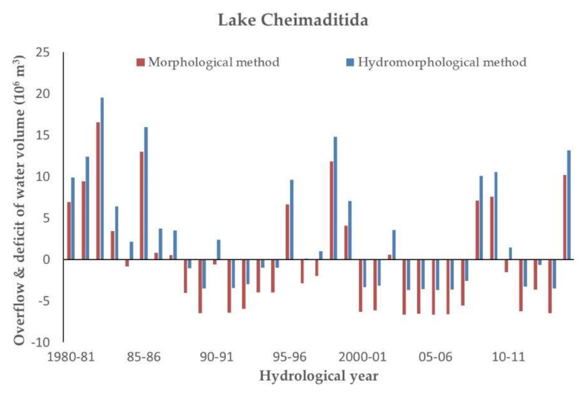
  • Figure 6 shows the hydrological evaluation of the two methods in Lake Cheimaditida. According to the morphological method, deficit was observed for 21 years and overflow for 14 years, while in the case of hydromorphological method, deficit was observed for 16 years and overflow for 19 years.
  • Figure 7 shows the hydrological evaluation of the two methods in Lake Zazari. According to the morphological method, deficit was observed for 20 years and overflow for 15 years, while in the case of hydromorphological method, deficit was observed for 16 years and overflow for 19 years.
As mentioned, the estimated minimum environmental water level will always be higher using the hydromorphological method compared to the morphological method (Table 2); for example the difference varied from 0.3 m in Lake Cheimaditida to 1.5 m in Lake Petron. However, what should be given special attention is the surface area shrinkage rather than the minimum water level assessed by each method, as a limited surface shrinkage (that occurs each year by adopting the minimum water level as a management instruction), will increase the protection of a lake’s biodiversity. For example, in Lake Petron, the minimum water level through the morphological method would decrease its maximum surface area by 17.7%, while if the hydromorphological method were to be adopted, its maximum surface area would decreased by only 6.1%, and thus ensuring a substantially reduced disturbance to the lake habitats.
Furthermore, a higher lake water renewal was achieved by using the hydromorphological method, compared to the morphological method. Particularly, the hydrological evaluation of the two methods (Figure 4, Figure 5, Figure 6 and Figure 7) revealed that the assessment of the minimum environmental water level in the four lakes by the hydromorphological method resulted in an increase in the number of hydrological years that a lake level rose to the maximum water level, as well as the increased water volume that overflowed from the lakes, and thus favours the lakes’ water renewal. These differences observed between the two methods are particularly significant in Lake Vegoritida and Petron, and less so in Lake Cheimaditida and Zazari.

4. Conclusions

The analysis of lake morphological features based on the surface area–volume–water level curves appears to be especially useful for making an initial estimation for a relatively safe assessment of the minimum environmental water level in lakes Vegoritida, Petron, Cheimaditida and Zazari. However, this method is based solely on the morphological features of the lakes without considering their hydrological status. As a result, the minimum water level could be estimated at particularly low levels, and thus, the rising from the minimum level to the maximum (overflow) level could not be achieved for many of the hydrological years.
To overcome this limitation, the proposed hydromorphological approach integrated morphological analysis and water balance in lakes, and mainly the water inflow from the lakes’ hydrological catchment areas. Using as a lake’s critical volume storage the annual water volume flowing into a lake from its hydrological catchment area with a probability of exceedance 50% of a long time series of hydrological years, a more comprehensive estimate of the minimum environmental water level assessment of the four lakes was obtained. Moreover, the raising from the minimum level to the maximum (overflow) level was ensured for most of the hydrological years, with simultaneous increases in the excess water volume transferred among the lakes, which is of great importance for the sustainable water management of the four lakes system in the hydrological catchment area of Lake Vegoritida, because the four lakes are connected through the hydrographic network of the catchment area and the overflow of water is transferred from the upstream lake to those downstream.
Even though very few steps have been taken so far and the appropriate legislation for the establishment of a minimum environmental water level in lakes and reservoirs is in its infancy, water managers are obliged to take measures to protect inland water bodies’ ecosystems and to meet the water requirements of the economic activities in their hydrological catchment area. To this direction, this work will be a useful tool to support scientifically sound water management decisions, as the applicability of the proposed hydromorphological method is straightforward and can be applied to any lake/reservoir for which water level–surface area–volume curves exist, and the annual water inflow from its catchment area can be safely estimated based on a long time series hydrological analysis.

Author Contributions

Conceptualization, C.D. and P.G.; methodology, C.D., P.G., P.D. and D.K.; software, P.K., D.K. and P.G; formal analysis, C.D., P.G. and D.K.; resources, C.D., P.D. and P.G.; data curation, P.G., P.K. and D.K.; writing—original draft preparation, C.D., P.K., P.G.; writing—review and editing, C.D., P.K., P.G., P.D. and D.K.; supervision, C.D., P.G. and D.K. All authors have read and agreed to the published version of the manuscript.

Funding

This research received no external funding.

Conflicts of Interest

The authors declare no conflict of interest.

References

  1. Tharme, R.E. A global perspective on environmental flow assessment: Emerging trends in the development and application of environmental flow methodologies for rivers. River Res. Appl. 2003, 19, 397–441. [Google Scholar] [CrossRef]
  2. Jain, S.K. Assessment of environmental flow requirements. Hydrol. Process. 2012, 26, 3472–3476. [Google Scholar] [CrossRef]
  3. Xu, Z.X.; Chen, M.J.; Dong, Z.C. Researches on the calculation methods of the lowest ecological water level of lake. Acta Ecol. Sin. 2004, 24, 2324–2328. [Google Scholar]
  4. Leeper, D.A.; Ellison, D.L. Proposed Minimum and Guidance Levels for Lake Hancock in Polk County, Florida; Southwest Florida Water Management District: Brooksville, FL, USA, 2015. [Google Scholar]
  5. Li, X.H.; Song, Y.D.; Li, Y.T.; Xing, X.; Zhang, S.Y. Calculation methods of lowest ecological water level of lake. Arid Land Geogr. 2007, 30, 526–530. [Google Scholar]
  6. Shang, S.H. Lake surface area method to define minimum ecological lake level from level-area-storage curves. J. Arid. Land 2013, 5, 133–142. [Google Scholar] [CrossRef] [Green Version]
  7. Cui, B.S.; Zhao, X.; Yang, Z.F. Eco-hydrology-based calculation of the minimum ecological water requirement for lakes. Acta Ecol. Sin. 2005, 25, 1788–1795. [Google Scholar]
  8. Abbaspour, M.; Nazaridoust, A. Determination of environmental water requirements of Lake Urmia, Iran: An ecological approach. Int. J. Environ. Stud. 2007, 64, 161–169. [Google Scholar] [CrossRef]
  9. Mjelde, M.; Hellsten, S.; Ecke, F. A water level drawdown index for aquatic macrophytes in Nordic lakes. Hydrobiologia 2013, 704, 141–151. [Google Scholar] [CrossRef]
  10. Wen, D.; Jin, C.; Shixiang, G.; Gang, C.; Jinming, C.; Mi, Z. Hydrological variability of water level of Dianchi lake and its application. IOP Conf. Ser. Mater. Sci. Eng. 2020, 780, 062048. [Google Scholar] [CrossRef]
  11. Shang, S.; Shang, S. Simplified lake surface area method for the minimum ecological water level of lakes and wetlands. Water 2018, 10, 1056. [Google Scholar] [CrossRef] [Green Version]
  12. Sajedipour, S.; Zarei, H.; Oryan, S. Estimation of environmental water requirements via an ecological approach: A case study of Bakhtegan lake, Iran. Ecol. Eng. 2017, 100, 246–255. [Google Scholar] [CrossRef]
  13. Petriki, O.; Zervas, D.; Doulgeris, C.; Bobori, D. Assessing the Ecological Water Level: The Case of Four Mediterranean Lakes. Water 2020, 12, 2977. [Google Scholar] [CrossRef]
  14. Stefanidis, K.; Papastergiadou, E. Relationships between lake morphology, water quality and aquatic macrophytes in lakes of Western Greece. Fresenius Environ. Bull. 2012, 21, 3018–3026. [Google Scholar]
  15. Papamichail, D.; Antonopoulos, V.; Georgiou, P.; Doulgeris, C.; Papadimos, D. Determination of the minimum water level and its variation of lakes by applying the percentiles method. In Proceedings of the 10th Conference of Hellenic Society of Agricultural Engineers, Athens, Greece, 28–29 September 2017; pp. 55–65. [Google Scholar]
  16. Gianniou, K.S.; Antonopoulos, Z.V. Evaporation and energy budget in Lake Vegoritis, Greece. J. Hydrol. 2007, 345, 212–223. [Google Scholar] [CrossRef]
  17. Doulgeris, C.; Pisinaras, V.; Argyroudi, A.; Tziritis, E.; Hatzigiannakis, E.; Panagopoulos, A. Impacts on water level fluctuation in Lake Vegoritida: Insights for the historical and projected climate period. Desalin. Water Treat. 2020, 194, 358–368. [Google Scholar] [CrossRef]
  18. National Water Monitoring Network. Available online: http://nmwn.ypeka.gr/en (accessed on 1 September 2019).
  19. Doulgeris, C.; Georgiou, P.; Apostolakis, A.; Papadimos, D.; Zervas, D.; Petriki, O.; Bobori, D.; Papamichail, D.; Antonopoulos, V.; Farcas, C.; et al. Assessment of the environmentally minimum lake level based on hydromorphological features. Eur. Water 2017, 58, 197–202. [Google Scholar]
  20. Greek Biotope Wetland Centre. Available online: http://biodiversity-info.gr (accessed on 5 February 2020).
  21. Charou, E.; Stefouli, M.; Dimitrakopoulos, D.; Vasiliou, E.; Mavrantza, O.D. Using remote sensing to assess impact of mining activities on land and water resources. Mine Water Environ. 2010, 29, 45–52. [Google Scholar] [CrossRef]
  22. Hellenic Statistical Authority. Available online: http://www.statistics.gr/en/home/ (accessed on 18 July 2018).
  23. Browne, R.A. Lakes as islands: Biogeographic distribution, turnover rates, and species composition in the lakes of central New York. J. Biogeogr. 1981, 8, 75–83. [Google Scholar] [CrossRef]
  24. Gippel, C.J.; Stewardson, M.J. Use of wetted perimeter in defining minimum environmental flows. Regul. Rivers: Res. Mgmt. 1998, 14, 53–67. [Google Scholar] [CrossRef]
  25. Nielsen, S.A.; Hansen, E. Numerical simulation of the rainfall runoff process on a daily basis. Nord. Hydrol. 1973, 4, 171–190. [Google Scholar] [CrossRef]
Figure 1. The hydrological catchment area of Lake Vegoritida, Petron, Cheimaditida and Zazari.
Hydrology 07 00083 g001
Figure 2. Water level–surface area–volume curves (left) and surface area–volume curves (right) in Lake Vegoritida, Petron, Cheimaditida and Zazari (source data: [20]).
Hydrology 07 00083 g002
Figure 3. Water inflow into Lake Vegoritida, Petron, Cheimaditida and Zazari from their subcatchment areas.
Hydrology 07 00083 g003
Figure 4. Overflow and deficit from the maximum volume in Lake Vegoritida from the hydrological evaluation of proposed methods for the hydrological years 1980–1981 to 2014–2015.
Hydrology 07 00083 g004
Figure 5. Overflow and deficit from the maximum volume in Lake Petron from the hydrological evaluation of proposed methods for the hydrological years 1980–1981 to 2014–2015.
Hydrology 07 00083 g005
Figure 6. Overflow and deficit from the maximum volume in Lake Cheimaditida from the hydrological evaluation of proposed methods for the hydrological years 1980–1981 to 2014–2015.
Hydrology 07 00083 g006
Figure 7. Overflow and deficit from the maximum volume in Lake Zazari on the hydrological evaluation of proposed methods for the hydrological years 1980–1981 to 2014–2015.
Hydrology 07 00083 g007
Table 1. Hydromorphological features in Lake Vegoritida, Petron, Cheimaditida and Zazari.
VegoritidaPetronCheimaditidaZazari
Maximum water level a.m.s.l. (m)518573.1592599.7
Maximum surface area (km2)47.212.610.12.0
Maximum stored volume (106 m3)1206.240.814.79.7
Average depth (m)263.51.55
Maximum depth (m)52.65.54.87.6
Table 2. Maximum water level and proposed minimum water level according to the morphological and hydromorphological methods in Lake Vegoritida, Petron, Cheimaditida and Zazari.
VegoritidaPetronCheimaditidaZazari
Maximum water level (m)518.0573.1592.0599.7
Proposed minimum water level (m)
Morphological method516.2571.1591.3596.0
Hydromorphological method517.6572.6591.6596.7
Publisher’s Note: MDPI stays neutral with regard to jurisdictional claims in published maps and institutional affiliations.

