Article

Evolution of the Upper Reaches of Fluvial Systems within the Area of the East European Plain Glaciated during MIS 6

1
Institute of Geography Russian Academy of Sciences, Staromonetny Lane 29, 119017 Moscow, Russia
2
Faculty of Geography, Lomonosov Moscow State University, Leninskiye Gory 1, 119899 Moscow, Russia
*
Author to whom correspondence should be addressed.
Submission received: 17 November 2021 / Revised: 6 January 2022 / Accepted: 20 January 2022 / Published: 22 February 2022
(This article belongs to the Special Issue Fluvial Archives: Climatic and Topographical Influences)

Abstract

:
The headwaters of fluvial systems on the East European Plain between the boundaries of the Marine Isotope Stage 2 (MIS 2) and MIS 6 glaciations evolved during the last 150,000 years. At least three main events of high surface runoff caused intensive erosion: at the end of MIS 6, at the end of MIS 2 and in the Middle Holocene. Erosion developed in the territory with variable resistance of geological substrate, from hard-to-erode tills to weak sandy deposits. All erosional features in moraines formed in the pre-Holocene time. Even relatively large forms, such as balkas (small dry valleys), have not yet reached concave longitudinal profiles. A general tendency of their development was deepening. Short episodes of incision occurring during climatic events with increased water flow alternated with long periods of stabilization. Sand-covered areas are most favorable for linear erosion. The gullies formed in the Middle Holocene developed concave longitudinal profiles. The diversity of catchment areas, initial slope inclinations and sediment properties causing their resistance to erosion led to greater differences in the relief features and evolution of the upper reaches of the fluvial systems within the MIS 6 glaciation area compared to the more uniform landscape conditions in the extraglacial regions.

1. Introduction

The relief is one of the most inert components of the landscape, second only to the lithological basis in this respect. Changes in climatic conditions influence the relief-forming processes, but in spite of their changing character, the relief retains relic components corresponding to the entirely different conditions of relief formation for a long time. The main question is, for how long such relic geomorphological features would be preserved in the landscape, and what are the mechanisms of their transformation under the changing landscape and climatic conditions. Unlike the development of river valleys [1], the response of the upper reaches of the fluvial systems to the climate change is not that well understood.
In the northwestern part of the East European Plain covered by continental icesheet in MIS 6, erosional and fluvial features since then have slowly replaced a typical glacial relief. During the last 150,000 years, the primary moraine plain was transformed to a so-called secondary moraine plain [2]. On the base of the initial geomorphic complex of moraine hills with depressions between them, meltwater channels and lacustrine basins, a fluvial complex of river valleys was formed with terraces and floodplains, and with a dense network of tributaries of different lengths. The same processes of fluvial landforms replacing primary glacial relief were widespread over all of the territory previously covered by MIS 6 glaciation in other regions of Europe—in Poland [3] and Germany [4,5], as well as in North America [6]. In these fluvial systems the headwater elements, each only a few kilometers long, are of the high importance, as their total length is up to 80% of the entire length of the channel network [7].
Here we discuss processes that took place in the headwater elements of fluvial systems—dry valleys and gullies—between the boundaries of the MIS 2 and MIS 6 glaciations, evolution of these erosion features during the last 150,000 years and the main similarities and differences between the evolution of such elements in the glaciated and extraglacial territories [8]. The main information was collected by the authors in the key area situated in the southwestern part of the territory, close to the edge of MIS 6 icesheet, with additional data from published sources.
The article uses the following terms to designate different types of erosional forms typical for the study area:
meltwater channel—long and wide hollow formed by streams of melted glacial waters during MIS 6 and filled with glaciofluvial deposits;
balka—small dry valley usually more than 5 m deep, with stable slopes and flat bottom covered by vegetation, often contains creeks in humid areas;
lozhbina—dry hollow, shallower than balkas, with stable gentle slopes covered by vegetation, some of them are sediment-filled balkas;
gully—active small erosional form with steep sides prone to landslides, usually more than 1.5–2 m deep.

2. Materials and Methods

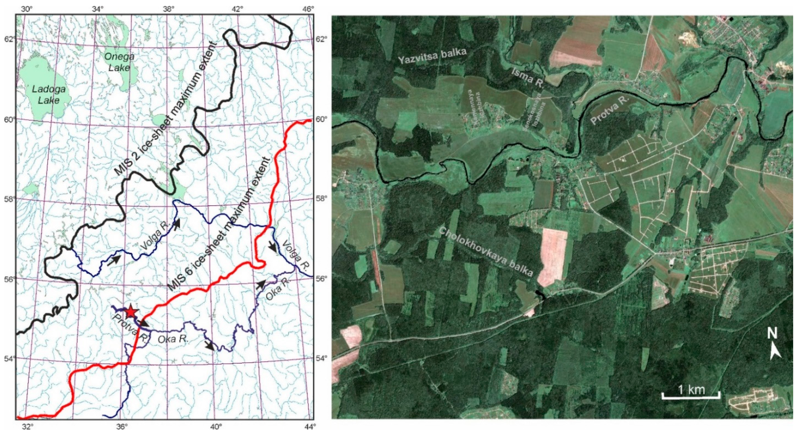
2.1. Geological and Geomorphological Setting of the Territory

On the East European Plain [2,9,10], as well as in the adjacent territories [11,12], lithological and geomorphological features distinguish the boundaries of Quaternary glaciations. The clearest are the boundaries of the Last Glaciation corresponding to Marine Isotope Stage 2 (MIS 2) and those of the Penultimate Glaciation (MIS 6) (Figure 1). Between these two boundaries, glacial deposits mostly belong to MIS 6, or Moscovian glaciation, according to the Russian geological nomenclature [10]. According to the map of Quaternary deposits of Russia [9], the main lithological formation in this territory is the MIS 6 moraine, which covers about 60% of the area, partially overlain by mantle loams. Glaciofluvial deposits, mainly sand and gravel, cover 21%, and glaciolacustrine deposits, mostly silt and clay, occupy 19% of the territory. In the northern part of the territory, relatively high ridges of the end moraines represent the primary glacial relief of MIS 6. In its southern part, much flatter land and even relief mostly formed by dead ice is widespread. There, shallow glaciofluvial channels separate low hills of MIS 6 moraine, the overall relief amplitude being a few tens of meters.
The studied key area is located in the marginal zone of MIS 6 glaciation, on the southeastern macroslope of the Smolensk-Moscow Upland, near the town of Borovsk (Northern Kaluga Region) (Figure 1). This territory is used for field geographical practice of the students of Geographical Faculty, Moscow State University [13]. The climate of the region is temperate continental with clearly defined seasonality [14]. The winter lasts about five months; the mean January temperature is about −10 °C; in severe winters, frosts can reach −40 to −47 °C. The average July temperature is about 18 °C. Annual precipitation is 650–700 mm. The main source of water for rivers is snowmelt water, which accounts for 50% of the annual runoff. The share of underground feeding is 30%, and that of the rainfall is about 20% [13].
The study area largely falls within coniferous broad-leaved forests, near the northern border of the broad-leaved forest zone [15]. The native forests here were dominated by spruce (Picea abies), linden (Tilia cordata) and oak (Quercus robur), and less often—by pine (Pinus sylvestris) on sandy ground and alder (Alnus) and willow (Salix) along the rivers. Forest logging led to formation of secondary small-leaved forests of gray alder (Alnus incana), aspen (Populus tremula) and birch (Betula sect. Albae). Meadows are located on the river floodplains and in the balkas. Soil cover of the territory is mainly composed of sod-podzolic soils (Podzoluvisols) formed on mantle loams.
The anthropogenic transformation of landscapes started about 2000 years ago, when people of Dyakovo culture used the Protva River valley for settlements [13]. That was the time of initial forest logging and burning by humans to clean small patches for arable land. The area of arable land increased gradually through time and reached its maximum at the middle of 18th century, when about 65% of the land was plowed [13]. Now the share of arable land is 35%, that of pastures—10% and that of forests—48%.
The main hydrographic elements in the study area are the Protva River and its tributaries, the largest of them being the Isma River, and balkas—Yazvitsa and Cholokhovskaya. The river network is characterized by presence of straight segments and changes in the direction of the valleys at angles of 45–90°. This pattern of the river network is due to the fracturing of the limestone basement and the features of the relief formed by the Moscovian (MIS 6) icesheet.
The latitudinal section of the Protva River divides the territory into two parts: the northern one, the Ruta–Protva interfluve, and the southern one—the Protva–Luga interfluve (Figure 2). In the southern part, the difference in altitudes between the main watershed at about 240 m above sea level (a.s.l.) to the bottom of the Protva valley at 127 m a.s.l. reaches 113 m. In the northern part, on the left side of the Protva River, the altitudinal range does not exceed 80–85 m. The depths of incision of the Protva River valley and of its main tributaries reach 40–50 m [16]. The density of the fluvial network (rivers and creeks) is 1.3–1.4 km/km2. There are more than 40 gullies within this small area of 44 km2.
Parent rocks are of the Carboniferous age [16]. The most ancient of them belong to the Vereian and Kashirian horizons of the Middle Carboniferous. The Vereian horizon is represented by layered clays and limestones. The Kashirian horizon is represented by limestones, dolomites, and in the upper part, by marls with rare thin interlayers of clays and limestones. The variation in the altitudes of the surface of the Carboniferous rocks reaches 100 m, from 186 m a.s.l. in the southeast of the study area to 130 m a.s.l. in the northwest, with deep ancient valley in between with the thalweg at about 87–88 m a.s.l.
The thickness of the Quaternary deposits averages around 20–30 m and varies from 0 m in the southern part of the territory to 90 m in the valley of the Protva River. Generally, the topography of the area follows an asymmetry of the Carboniferous basement. At the end of the Middle Pleistocene, the main relief features of the area was formed by glacial and glaciofluvial processes that developed during the melting of the MIS 6 icesheet.
Currently it is so-called secondary morainic plain dissected by valleys of the Protva River and its tributaries. The relief of the interfluves is smooth, and slopes are gentle (generally less than 5°). The most common relief features are hills and depressions in moraine, channels formed by glacial meltwater runoff and ancient lake basins filled in with sediments and often occupied by modern mires. The interfluves are composed by sandy loams of bright red-brown color, with boulders, which is very typical of the MIS 6 moraine. Glaciofluvial deposits of MIS 6 age (sand and sandy loam with pebbles and gravel) compose the bottoms of meltwater channels. A layer of mantle loams 1.2–1.8 m thick overlays the deposits of MIS 6 and MIS 5 ages. During MIS 4 and MIS 2 glacial stages, the territory was within the periglacial zone [2,10].

2.2. Methods of Sedimentological and Paleogeographical Studies

The structure of the glacial and glaciofluvial relief of the key area was studied using the satellite and airborne images and large-scale topographic maps. About 200 boreholes were cored within the area to investigate sedimentary lithology and stratigraphy [16]. The main attention was concentrated on the relief and sediments of several large balkas and lozhbinas in the Protva River catchment area. Ground geodesic survey of these erosion forms was performed with a high-precision GPS (Trimble 4000 SSE/SST set). A digital model of the modern topography and a digital elevation model of the MIS 6 moraine surface were used for the analysis.
The deposits in the valleys, balkas and gullies were studied in the outcrops, trenches and cores. Particle size of the sediments filling in the fluvial forms was studied by 8- and 31-fractional analyses. Fractions >0.1 mm were separated by dry sieving on Analysette 3 Pro vibratory sieve shaker after preliminary destruction of the aggregates. Fractions ≤ 0.1 mm were dispersed with sodium pyrophosphate and separated in 8-fractional analysis by pipette method and in 31-fractional analysis using Analysette 22 Comfort laser diffraction facility. Soil texture classes were also estimated in the field using principles of USDA textural triangle [17].
Radiocarbon dating of sediments was performed in several different laboratories with the following indices: MGU—Moscow State University, Moscow, Russia (closed); IGAN—Institute of Geography RAS, Moscow, Russia; Ki—Institute of Radio-Geochemistry of the Environment, Kyiv, Ukraine. Information on the laboratories is available at [18]. Some of the 14C dates used in the current paper were published in [19], Table 3.
For reconstructing environmental and climatic conditions of sedimentation, pollen analysis was applied [20]. Palynological data were also used as bio-stratigraphical criteria. Pollen diagrams of the Last (Mikulino) Interglacial in the East European Plain show a characteristic sequence of the regional pollen zones [21], which makes the deposits of the Last Interglacial a reliable bio-stratigraphic marker.

3. Results

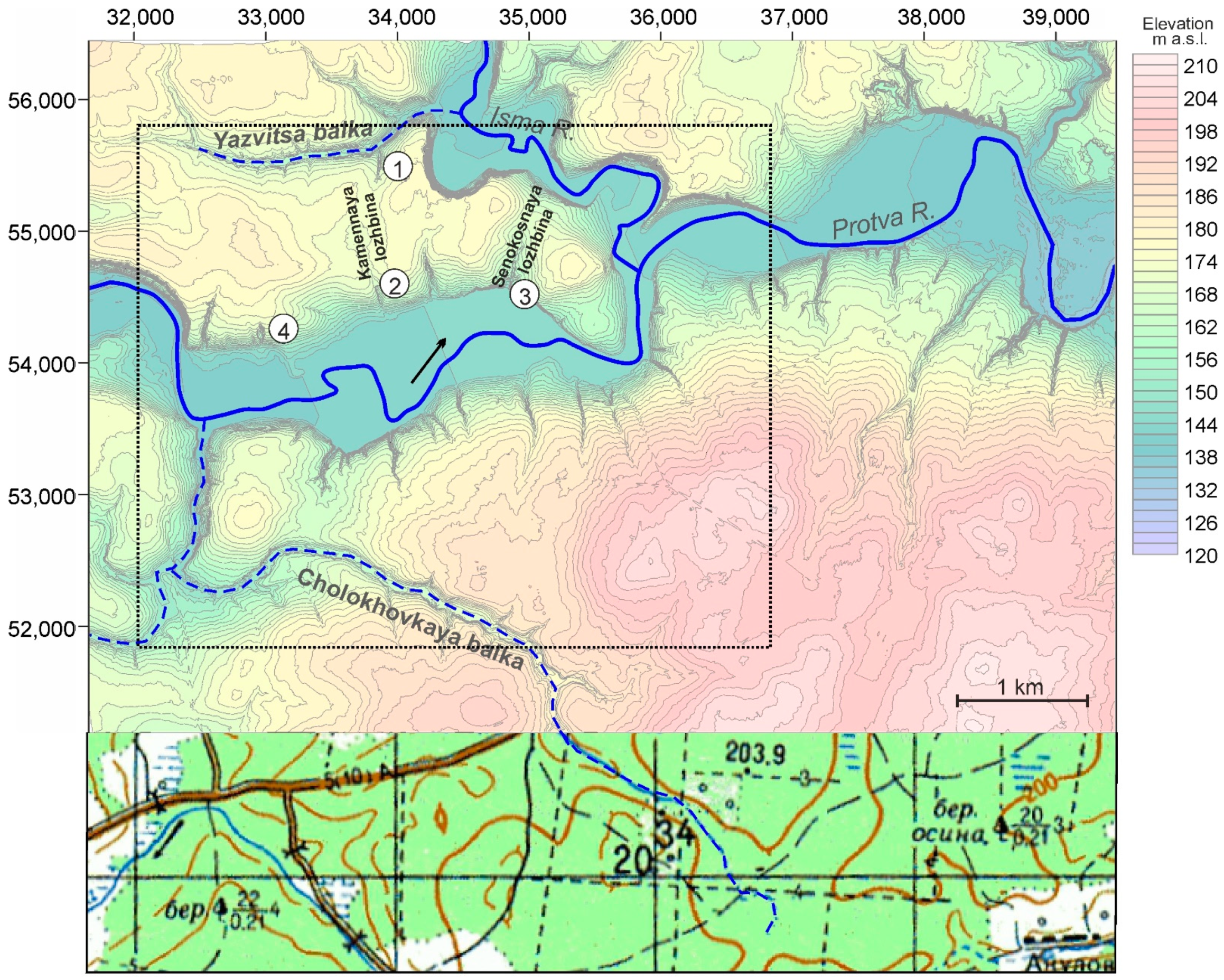
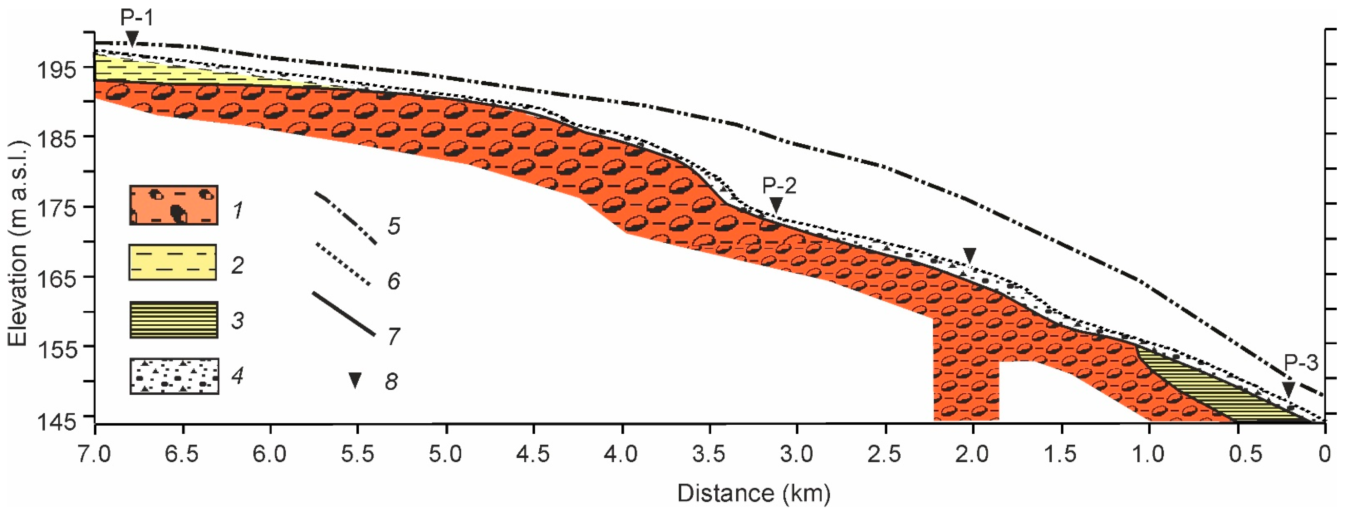
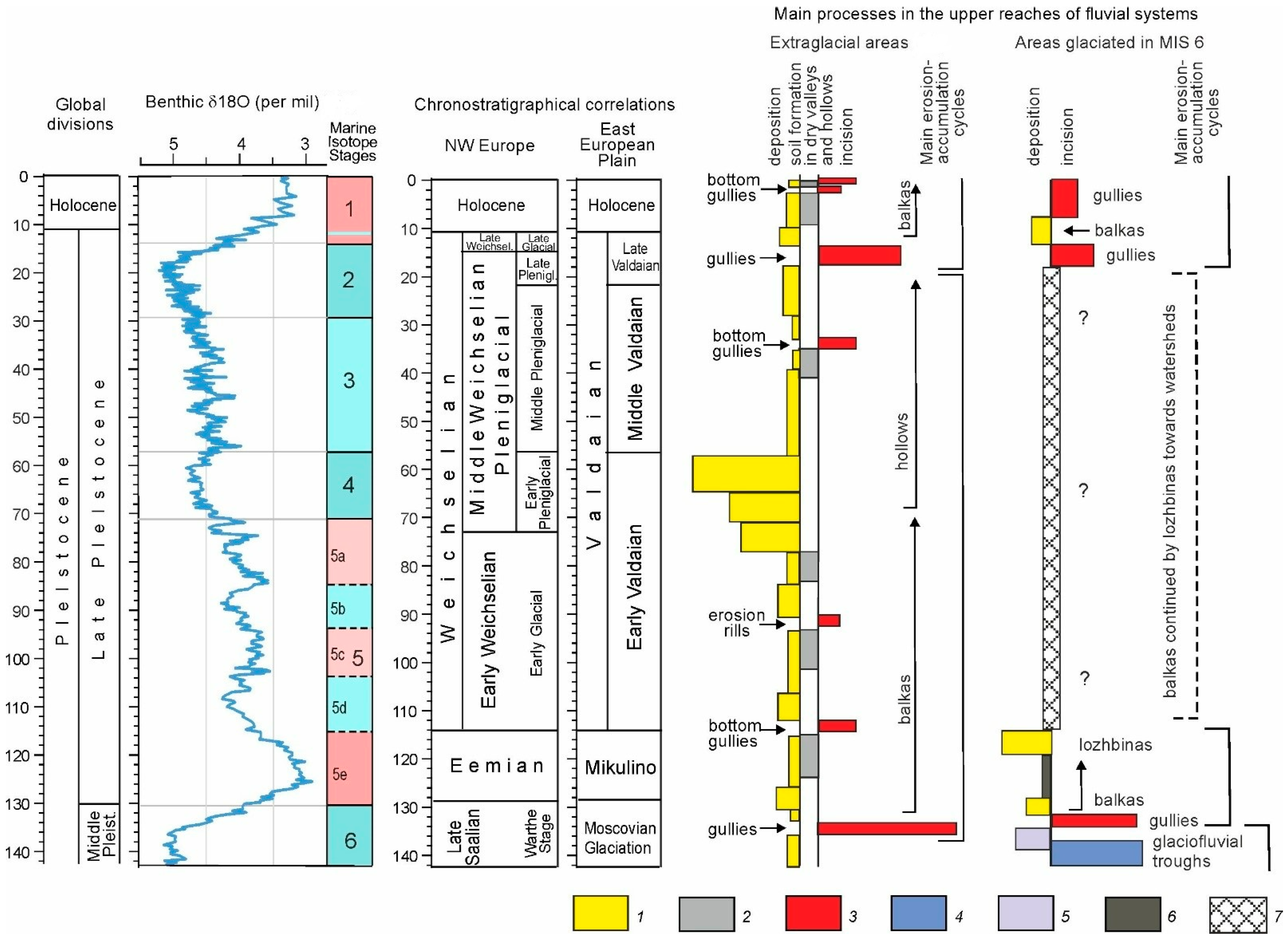
3.1. Post-Glacial Relief near the Southern Boundary of the MIS 6 Glaciation

A digital elevation model (DEM) of the surface of the MIS 6 morainic plain was built on the basis of the altitude position of the moraine determined in more than 70 cores for the territory with an area of 18 km2. The data on the locations of the boreholes are published in [22]. The DEM (Figure 3) shows the system of low, flat moraine hills with the tops at 180–205 m a.s.l. separated by shallow meltwater channels with the bottoms at 160–170 m a.s.l.
Figure 3. The relief of the MIS 6 moraine surface in the key area in the Protva River basin. Keys: 1—positions of the cores and altitudes of the tops of the MIS 6 till and parent rocks; 2—isolines of the altitude; 3—river valleys; 4—small erosion forms: a—inherited, in the meltwater channels, b—eroded on the slopes of moraine hills; 5, 6—moraine hills with Quaternary deposits’ thickness: 5—<25 m and 6—>25 m; 7—slopes of moraine hills; 8—depressions with peat deposits. Numbers in circles show positions of the SEFs: 1—Kamennaya Lozhbina, 2—Senokosnaya Lozhbina, 3—Yazvitsa Balka, 4—Cholokhovskaya Balka (the main geomorphological features adapted from [22]).
Quaternary 05 00013 g003
The overall relief structure is inherited. The pattern of hills and meltwater channels is nearly orthogonal, following the pre-Quaternary relief structure of this territory [23]. The low amplitude of surface relief (only 20–35 m) of the MIS 6 deposits is the result of sedimentation processes during ice-melting phases—formation of morainic cover on the interfluves and glaciofluvial and glaciolacustrine deposits in the depressions.
An outstanding feature of the relief in this flat undulating area is the modern valley of the Protva River with its main tributary, the Isma River. The boreholes in the investigated stretch of the valley reached the basal rocks—the Carboniferous limestones and clays—at the altitudes of 105–115 m a.s.l., that is, 25–30 m below the deepest pools of the modern Protva River [16,22]. Partly, karstic processes could cause this local over-deepening of the valley, but such local processes could not form a general geometry of the deep and wide trough of the Protva River valley. Subsequently, the meltwater channel was filled in by glaciofluvial deposits during the MIS 6 late glacial time and in the course of complicated evolution of the valley in MIS 5–MIS 1 [24].

3.2. Post-Glacial Evolution of the Upper Reaches of the Fluvial Network

The modern fluvial network within the territory, which was covered by the icesheet in MIS 6, partly inherited the drainage channels of the glacial melt water and partly formed on the slopes of morainic hills. We investigated the processes of erosion and deposition along such drainage channels of different sizes and with a varying degree of the postglacial transformation. As the result, two main types of small erosional forms (SEFs) were distinguished in the upper reaches of the fluvial network (see Figure 3):
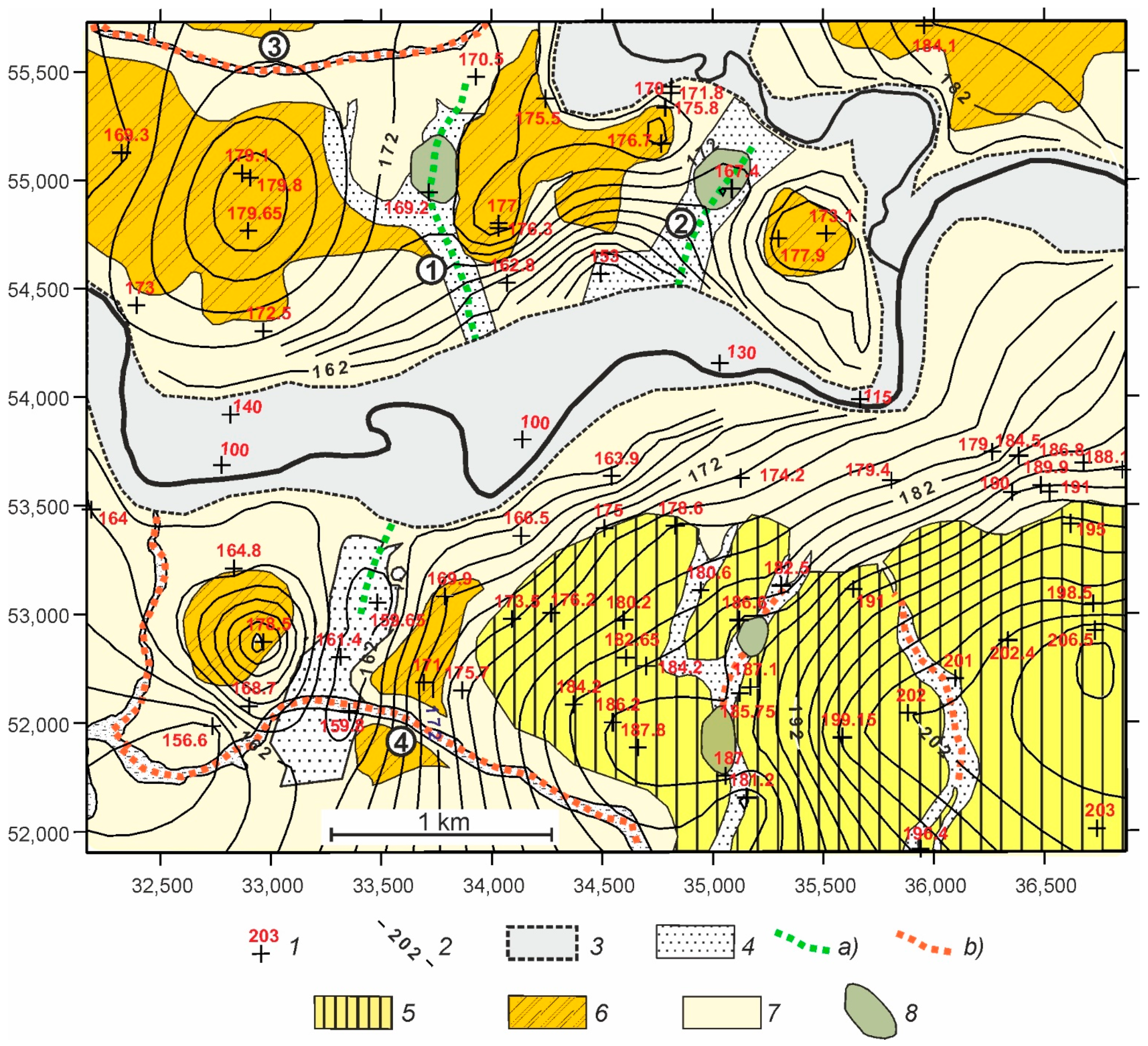
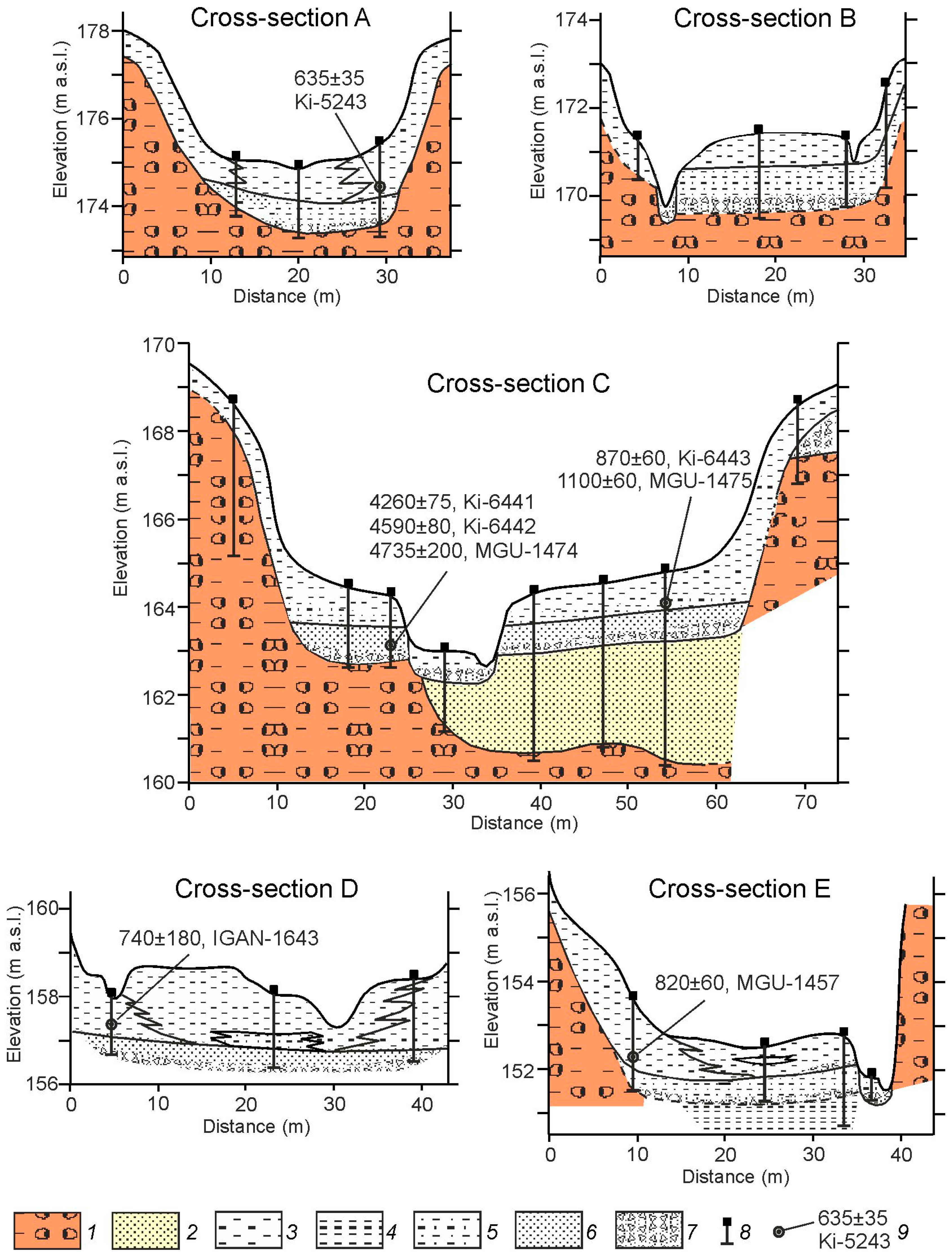
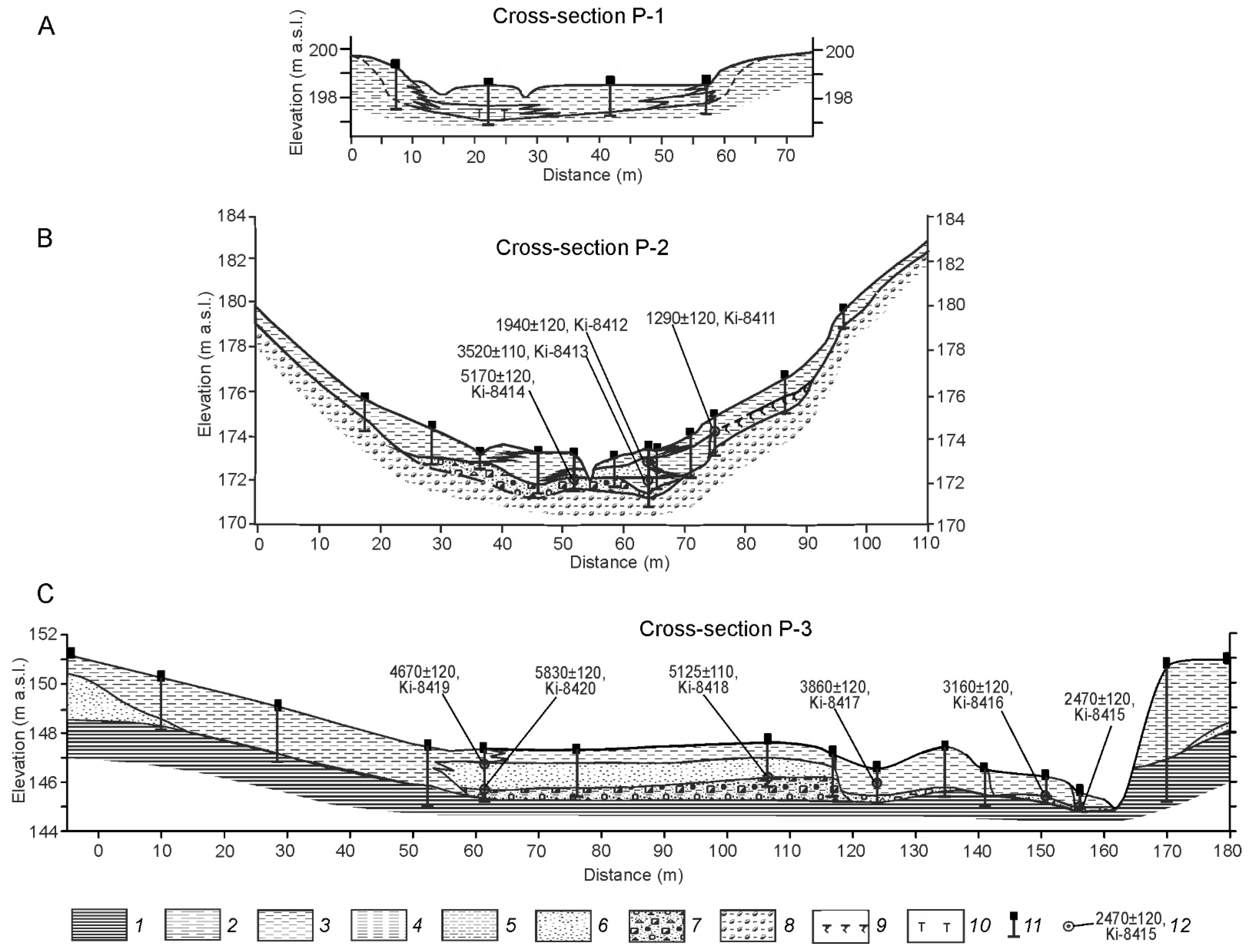
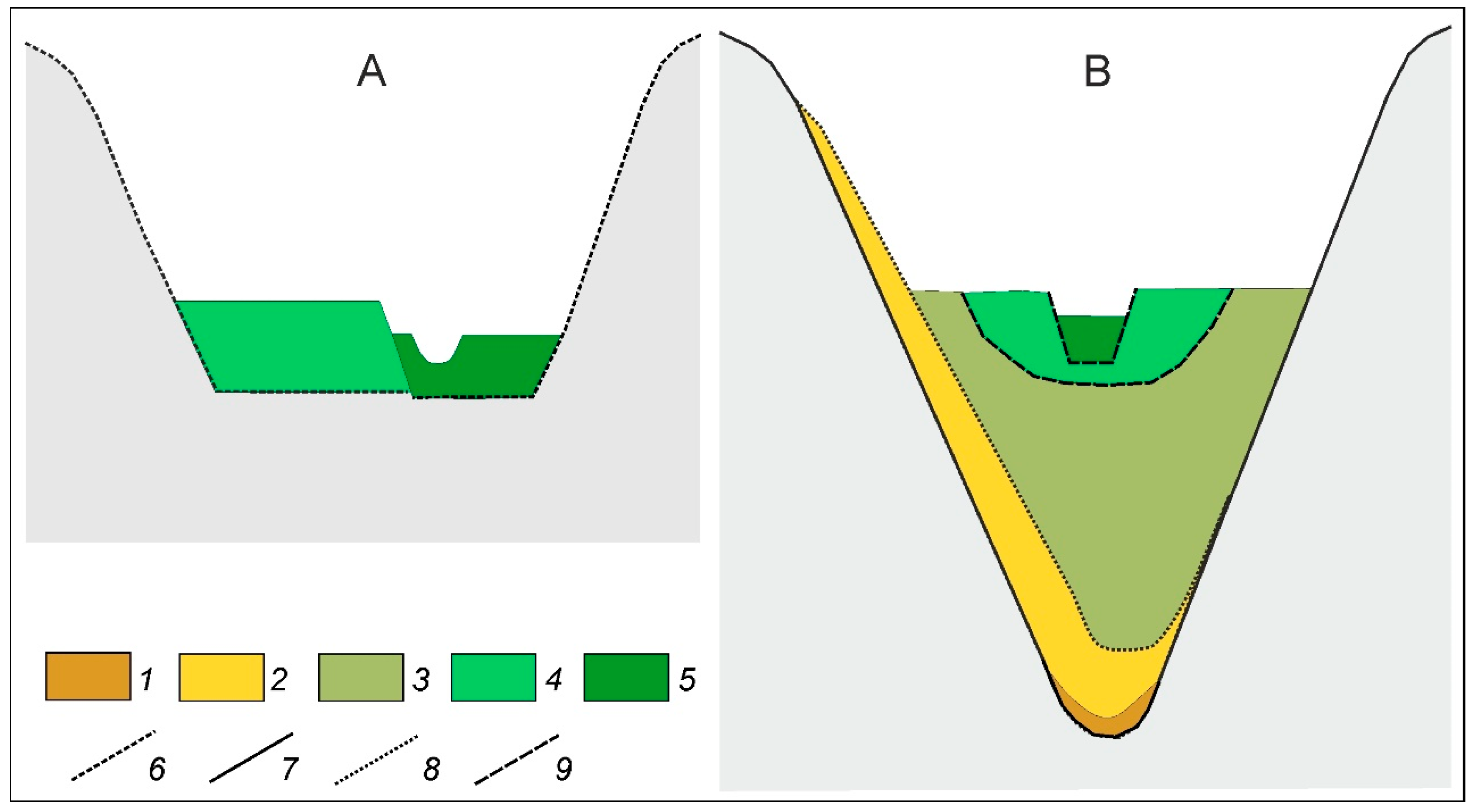
  • SEFs, which inherited glacial meltwater channels, mostly of meridional direction. These troughs were filled with glaciofluvial sand and silt deposits and prior to the incision of SEFs had nearly flat bottoms and gentle slopes.
  • SEFs with U-shaped valleys with steep slopes and wide bottoms, often with creeks (balkas). Such SEFs are mostly incised into dense loams with abundant gravel and boulders—moraines of MIS 6 or earlier glaciations—and largely have latitudinal direction. At some stretches, these forms also inherited glaciofluvial or glaciolacustrine relief features. Often, they change direction to longitudinal and follow the remnants of glacial meltwater channels filled in with sand and silt. Some of these SEFs follow deep linear features of Carboniferous basement [16].

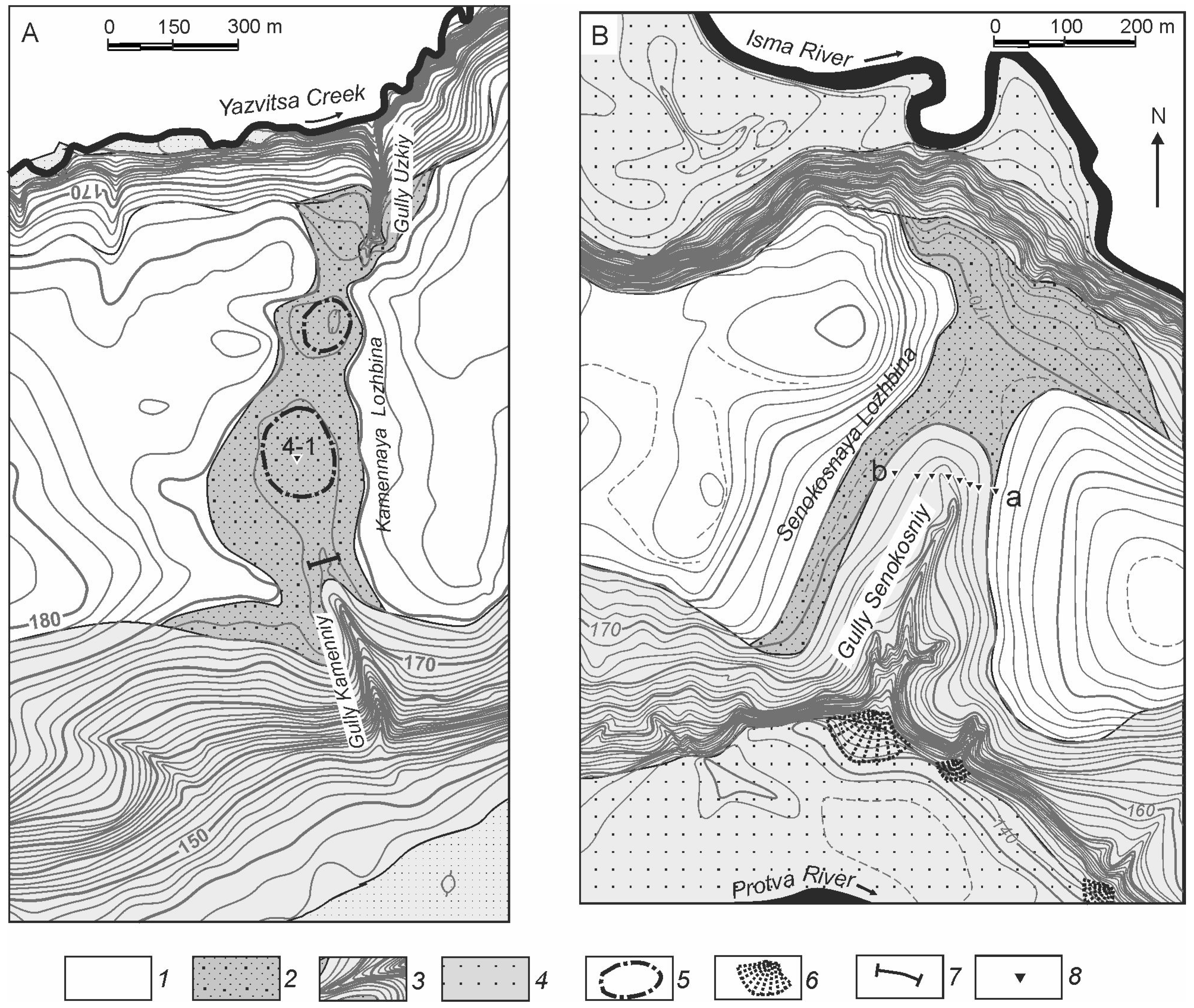
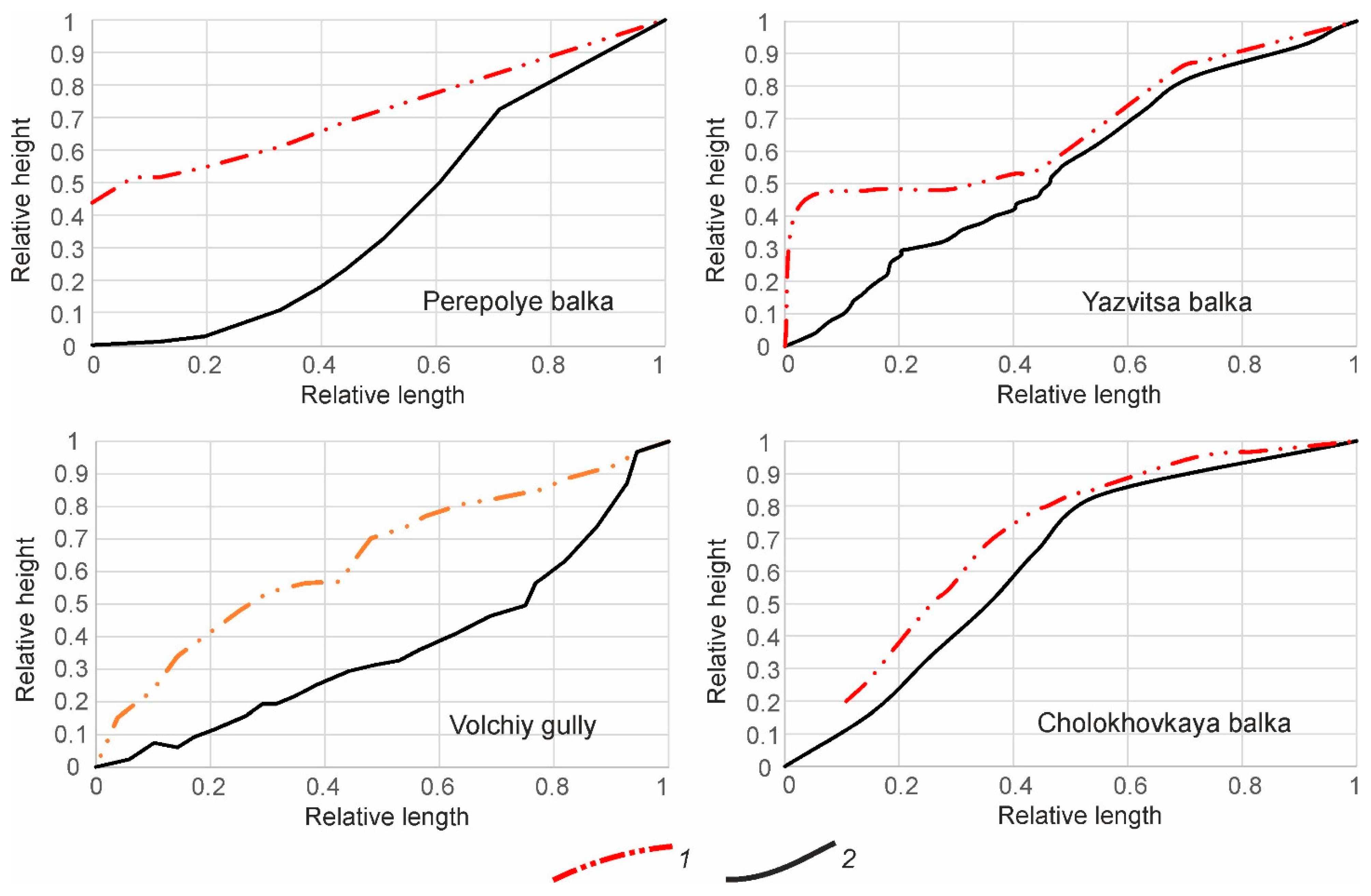
3.2.1. The Lithological Structure and Evolution History of SEFs Type 1

Two SEFs of the first type, with local names Kamennaya Lozhbina (number 1 in Figure 3) and Senokosnaya Lozhbina (number 2 in Figure 3), were investigated (Figure 4). The Kamennaya Lozhbina (Figure 4A) is 650 m long, with the basin area of 0.66 km2. It stretches between the valleys of the Protva River and the Yazvitsa Creek. Borehole 4–1 was cored in one of the waterlogged depressions in the middle part of the Kamennaya Lozhbina and penetrated a layer of mantle (cover) loam about 2 m thick and glaciofluvial sandy loam 2.5 m thick, overlaying the MIS 6 moraine. The trench in the southern part of the Kamennaya Lozhbina showed about 2 m of deposits overlying the MIS 6 moraine, of which the lower 0.5–0.7 m deposits are slopewash (solifluction) and fluvial sediments and the upper 1.3–1.5 m are mantle loams. The trench in the northern part of the Kamennaya Lozhbina exposed lacustrine deposits of MIS 6, covered by slopewash (solifluction) and glaciofluvial sediments about 1.5 m thick.
These lithological sequences show that the Kamennaya Lozhbina was formed during the MIS 6 glaciation as the result of glaciofluvial and glaciolacustrine erosion and accumulation. Later on, the Kamennaya Lozhbina was filled in by slopewash sediments, followed by formation of the mantle loams. No traces of erosion were found here for the period from the end of MIS 6 to the Holocene. In the basin of the Protva River, several other SEFs of type 1 were drilled in order to study the composition of the sediments filling them. All these SEFs were filled in by mantle loams, directly overlaying glaciofluvial deposits of MIS 6 [23].
Two gullies cut into the Kamennaya Lozhbina from two sides—the Uzkiy gully in the north and the Kamenniy gully in the south. The Uzkiy gully (Figure 5) is about 250 m long with the basin area of 0.16 km2. In the upper 95 m, the gully cuts into glaciofluvial and lacustrine sand and silt. In its lower part, the gully is incised into more resistant moraine on the slope of the Yazvitsa Creek. Several 14C dates show that the gully reached its full length about 1700 years BP and was stable after that. The Kamenniy gully is about 400 m long with the basin area of 0.5 km2. Its upper part about 150 m long cuts into a wide waterlogged flat part of the Kamennaya Lozhbina bottom; the lower part of the gully cuts the slope of the Protva River valley.
Another SEF of the first type—the Senokosnaya Lozhbina, is 550 m long, with the basin area of 0.27 km2 (number 2 in Figure 3). It crosses the interfluve between the valleys of the Protva River and the Isma River (Figure 4B). In the north, the Senokosnaya Lozhbina merges with a fragment of a sandy outwash terrace in the valley of the Isma River (valley sandur), supposedly formed by meltwater from the MIS 6 icesheet. In the northern part, the Senokosnaya Lozhbina has an asymmetric box-shaped transverse profile with a western slope of 10–12° and an eastern slope of 6–8°. In the southern part, its transverse profile is V-shaped with symmetrical slightly convex slopes of 7–8°.
Mantle loams that are 1–5 m thick cover slopes and the bottom of the Senokosnaya Lozhbina along its entire length (Figure 6). The composition of mantle loam is dominated by silt particles (mostly coarse silt)—from 68% to 71% (Figure 7). The content of clay particles is 20–23%, and that of sand is 6–8%.
The lower part of these deposits can be interpreted as products of deluvial (slopwash) and solifluction processes. The composition of this layer differs from the mantle loam by higher sand contents (20–45%) and inclusions of gravel.
Several cores showed a rather complicated composition of the deposits underneath the mantle loam. Slopes of the initial glacial meltwater channel are composed of the MIS 6 moraine (glacial till) of the typical red-brown color. It mainly consists of the loam with numerous inclusions of gravel and small boulders, with interlayers and lenses of sand with gravel, sandy loam and clay. For moraine, polymodal particle size distribution is characteristic (Figure 7). Two maximums were detected, in the sand (from 30% to 80%) and in the silt (up to 40%), with a gap between them in the particle sizes 60–80 μm. The grain-size distribution of moraine fundamentally differs from that of the mantle loams by existence of the maximum of sand particles.
The buried meltwater channel formed at the end of MIS 6 is incised into moraine. It is about 8 m deep and 120 m wide (Figure 6). It is filled by light grey, predominantly fine and medium-grained sand. The layer of brown-grey loam and sandy loam with the total thickness of 40–50 cm (number 3 in Figure 6) overlies the glaciofluvial sand. A gradual decrease in the intensity of the dark color from top to bottom of this interlayer suggests that it might be a buried soil remnant.
A narrower U-shaped erosion form 20–50 m wide (an ancient gully) is incised into the glaciofluvial sandy filling of the meltwater channel. This ancient gully is in its turn filled in with deposits with the total thickness of about 10 m (Figure 6). The deepest part of the buried gully at the cross-section a–b is filled with brown-grey medium loam (number 3 in Figure 6) and peat with plant remains (number 4), with a total thickness about 3.5 m. This organic layer is overlayed by slopewash deposits—light brown sandy loam with lenses of grey loam and dark grey loam with spots of yellow sand (number 5) with a total thickness of about 4.5 m. The topmost layer is composed of mantle loams (number 6) about 2 m thick. In other cored cross-sections the composition of sediments is similar, although the thickness of the layers varies.
Pollen analysis of the peat and brown-grey loam showed a sequence of pollen zones typical of the Last (Mikulino) Interglacial period [25]. Peat deposits of this age are widespread on the territory previously covered by MIS 6 continental icesheet. The Last Interglacial peat deposits are found in the former oxbows on the river terraces, in the depressions on the surface of MIS 6 moraine and in the ancient gullies and dry valleys (balkas) [26,27]. Correlation of the regional pollen zones for the Mikulino Interglacial with those for the Eemian Interglacial in Western and Central Europe is well established [28,29]. The generally agreed equivalent of the Last Interglacial sensu stricto in the deep-sea sediments is Substage 5e of MIS 5 [30,31].
The sediment structure and morphology of the Senokosnaya Lozhbina make it possible to reconstruct its postglacial history. At the stage of degradation of the MIS 6 icesheet glacial, the melt water formed a channel, which afterwards was partly filled with glaciofluvial sand. At the very end of the Middle Pleistocene (in the Late Glacial period of the MIS 6 glaciation), an activation of erosion processes occurred along the middle part of the bottom of this meltwater channel, and a gully 10 m deep was formed, which flowed into the valley of the Protva River and almost reached the local watershed at the source. The intensification of linear erosion falls on the time of the change of landscape and climatic conditions from periglacial at the end of MIS 6 to interglacial in MIS 5e. At the beginning of MIS 5e, the process of incision ceased, and accumulation of loam (number 3 in Figure 6) occurred. The middle part of MIS 5e (the climatic optimum of the Last Interglacial) was the time of peat accumulation at the bottom of the gully. Later in MIS 5, the peat was overlain by deluvial (slopewash) deposits. After that, a layer of mantle loam, partially reworked by solifluction, covered both the bottom and the slopes of the Senokosnaya Lozhbina.
A new activation of erosion processes in the Holocene led to the formation of the modern gullies. As in the Kamennaya Lozhbina, two gullies cut the Senokosnaya Lozhbina from two sides—a small unnamed gully in the north and the Senokosniy gully in the south. The Senokosniy gully (Figure 8) is about 500 m long with the basin area of 0.23 km2. In the upper 300 m, the gully cuts loams and sands on the gentle local interfluve within the Senokosnaya Lozhbina. In its lower part, the gully is incised into more resistant moraine on the steep slope of the Protva River valley. The gully forms a fan on the floodplain of the Protva River. According to 14C date 10,380 ± 110 yr BP, this segment of the floodplain already existed at the beginning of the Holocene.
The gully erosion and accumulation of the fan probably began as early as in the Boreal and was soon followed by a strong forest fire. The maximum depth of fan deposits is about 4 m (Figure 8C). Numerous charcoal particles are dispersed within the gully fan and at the depth of 1.0–1.5 m dated by 14C in the range 2240–2700 years ago. Later on, the deposition rate on the fan decreased significantly, and the main area of sedimentation shifted up the gully (Figure 8B). The oldest deposits found at the very bottom of the gully filling indicate that deluvial-proluvial accumulation in the middle reaches of the gully began 2580 ± 70 years ago. The dates obtained from seven overlying samples calibrated with [32] indicate two stages of higher accumulation rates: about 2800–1600 years ago (~1.2 mm/yr) and from about 900 years ago to the present time (~1.6 mm/yr). Between these two accumulation stages, sedimentation rates were low but sufficient to prevent formation of soil horizon at the bottom of the gully. It is also possible that at some stages the sediments there were partly eroded.

3.2.2. The Lithological Structure and Evolution History of the SEFs Type 2

Two SEFs of type 2—large balkas with creeks—with the local names the Yazvitsa Balka and the Cholokhovskaya Balka were investigated (Figure 2 and Figure 3). The basin area of the Yazvitsa Balka (number 3 in Figure 3) is 6.5 km2, its length is 3.5 km and the depth reaches 22 m in the lower part of the valley. The permanent watercourse (the Yazvitsa Creek) begins about 0.9 km from its mouth. The lithological structure of this small valley bottom was studied at 10 cross-sections in more than 50 boreholes and outcrops (Figure 9 and Figure 10).
The Yazvitsa Balka is mostly incised into hard loam with boulders—the MIS 6 glacial till. The deposits overlying the till in the Yazvitsa Balka are relatively thin. At their base, across the entire width of the valley bottom, there is a gravel basal horizon 15–25 cm thick with a gently undulating base. The coarse particles in basal layer are presumably washed out underlying till and glaciofluvial deposits. It is covered with fine to medium-grained, in some layers well-sorted sand, changing upwards into sandy loam.
The structure and texture of the sediments (presence of the basal facies and thinning of the material from the lower to the upper layers) make it possible to interpret it as channel alluvium of a permanent watercourse. Such channel alluvium is found at least as far up the valley as 2.0 km from its mouth (cross-section B at Figure 10). It suggests that in the past a watercourse began further up the valley than 1000 m than at present. The total thickness of channel alluvium is 60–90 cm in most sections. The oldest radiocarbon date obtained on charcoal from this layer (see cross-section C, Figure 10) is 4735 ± 200 yr BP, which roughly corresponds to the border of the Atlantic and Subboreal periods of the Holocene. Presumably, all older sediments were washed out from the valley of the Yazvitsa Balka.
The sediments overlapping the channel alluvium are represented predominantly by light loam, often with distinct laminations (with alternating sandy loam and silt layers). In the upper reaches of the valley, these sediments are mainly of slopewash origin. In its middle course, they are deposits of merged fans of the small gullies and rills cutting the sides of the valley. The lower layer of slope deposits contains abundant charcoals up to 2–3 cm in size. The following radiocarbon dates (Figure 10) were obtained from charcoal at the base of slope deposits: 635 ± 75, 740 ± 180, 820 ± 60 and 1100 ± 60. Since these dates should include the biological age of trees, they can overestimate the time of the fire itself by up to 100 years. Nevertheless, the interval of 450 years between the dates, most likely, indicates several fire episodes.
The sediment succession described above shows that erosion was predominant along the main part of the Yazvitsa Balka, as only a small part of deposits is preserved there. Presumably, the valley of the creek 3.5 km long was mainly formed by erosional events at MIS 6 and MIS 2 Late Glacial periods. Due to a high resistance of moraine, the depth of incision was not large, and the valley bed was steep enough to cause a subsequent transportation of sediments. The beginning of the last erosion event here is dated by the end of the Atlantic period of the Holocene, when a flow transported sediments along the lower 2500 m of the creek valley. In the period 600–1100 years ago, as the result of a series of fires on the catchment, slope processes intensified, and parts of the valley bottom near the sides were covered by fans of the slopewash sediments.
The catchment of the Cholokhovskaya Balka has an area of 13.6 km2 (number 4 in Figure 3). The total length of the balka is about 7 km, and a permanent watercourse (the Cholokhovsky Creek) begins 3 km from its mouth (Figure 11). Four cross-sections were positioned across the bottom of the balka with the use of a high-precision GPS (Trimble 4000 SSE/SST set). The three most informative profiles are shown in Figure 12. More than 40 pits were excavated at the bottom and on the slopes of the balka to investigate the sediments.
The Cholokhovskaya Balka has a convex longitudinal profile (Figure 11). In its upper segment (7–4.5 km from the mouth, cross-section P-1, Figure 12A), the depth and width of the balka are small (1–2 m and 30–60 m, respectively). In the middle course (4.5–1.1 km, cross-section P-2, Figure 12B), the depth of the balka increases, reaching a maximum of 10–12 m 2.5–3.5 km from the mouth. Along with the depth, the overall width of the balka also increases to slightly over 100 m, but the width of its bottom does not exceed 40–50 m. In the lowermost 1100 m (cross-section P-3, Figure 12C), the balka’s depth gradually decreases to 3–4 m near its mouth, while both the total width and the width of the bottom increase significantly (up to 150–170 m and 100–120 m, respectively). Towards the watershed, the Cholokhovskaya Balka is continued by an elongated shallow swamped trough, which inherited a glacial meltwater channel of a longitudinal direction.
In this uppermost stretch of the balka, the glaciofluvial or glaciolacustrine sands and silts are found (Figure 12A, cross-section P-1). In the lowermost part of the Cholokhovskaya Balka (Figure 12C, cross-section P-3), the coring revealed ancient lacustrine and alluvial deposits 2–3 m thick covered with Holocene alluvia. According to palynological data, these deposits were accumulated during the Last Interglacial (MIS 5e) [33].
Along the major part of the Cholokhovskaya Balka, where it is incised into the MIS 6 till, there is no filling deposit older than the Holocene.
The Holocene alluvium in the middle part of the Cholokhovskaya Balka has a two-unit structure (Figure 12B, cross-sections P-2). At the base of the sediment sequence lies a basal horizon up to 0.8–0.9 m thick, composed of coarse sand and gravel. Radiocarbon analysis dated its formation back to the end of the Atlantic period of the Holocene (5170 ± 120 yr BP). The basal coarse clastic material is overlaid by sand and loam dated within the range 3520 ± 110—1940 ± 120 yr BP. Slopewash deposits with charcoals at their base dated to 1280 ± 120 yr BP overlie the alluvium near the slopes of the balka. Presumably, they are the result of increased slope erosion due to a forest fire.
In the lower stretch of the balka the modern channel of the creek is incised into the bottom sediments, thus forming a well-defined terrace (Figure 12C, cross-section P-3). The basal layer of alluvium 0.5–1 m thick is pebble and boulder pavement of erosional origin. The dates of 5830 ± 120 and 5125 ± 110 yr BP were obtained from the top of this layer. Basal alluvium is overlaid by 1–1.5 m of fine-grained sand and sandy loam and then by 50–70 cm of loam. The date of 4670 ± 120 yr BP was obtained from charcoal particles found at the base of the loam layer.
The most resent belt of the lateral migration of the creek channel (the floodplain of the creek) is about 40 m wide. Alluvium there also has a bipartite structure. The lower layer of gravel with pebbles is 30–40 cm thick; the upper layer of sandy loam is 1–1.5 m thick. Several radiocarbon dates obtained from various parts of the creek’s floodplain attributes its formation to the Late Subboreal–Early Subatlantic (3860 ± 120 BP; 3160 ± 120; 2470 ± 120 yr BP). On the transverse profile D in the lower stretch of the balka, the older basal horizon of alluvium under the terrace lies 0.7–1 m higher than the younger basal alluvium under the stream floodplain. This allows us to conclude that, during the Late Holocene, the process of incision of the balka continued, at least in its lower reaches.
The Cholokhovskaya Balka was formed by the erosion event at the end of MIS 6. This is confirmed by the presence of deposits of the Last Interglacial in the filling of the deepest incision in the lower reaches of the Cholokhovskaya Balka [33]. The deposits of the time interval from the later substages of MIS 5 to the beginning of the Middle Holocene are absent in both balkas.
Both of the balkas contain alluvial deposits of the Middle and Late Holocene. The structure of these deposits indicates that once watercourses with a typical channel evolution existed almost along the entire length of the balkas, whereas modern permanent creeks begin well below the heads of the balkas. An existence of channel alluvium upstream from the heads of the modern permanent creeks indicates the higher runoff stage of the Middle Holocene. The end of this stage was marked by the activation of erosion caused by release of material after fire episode, which led to the accumulation of slopewash sediments at the bottoms of the balkas, especially in the Yazvitsa Balka.

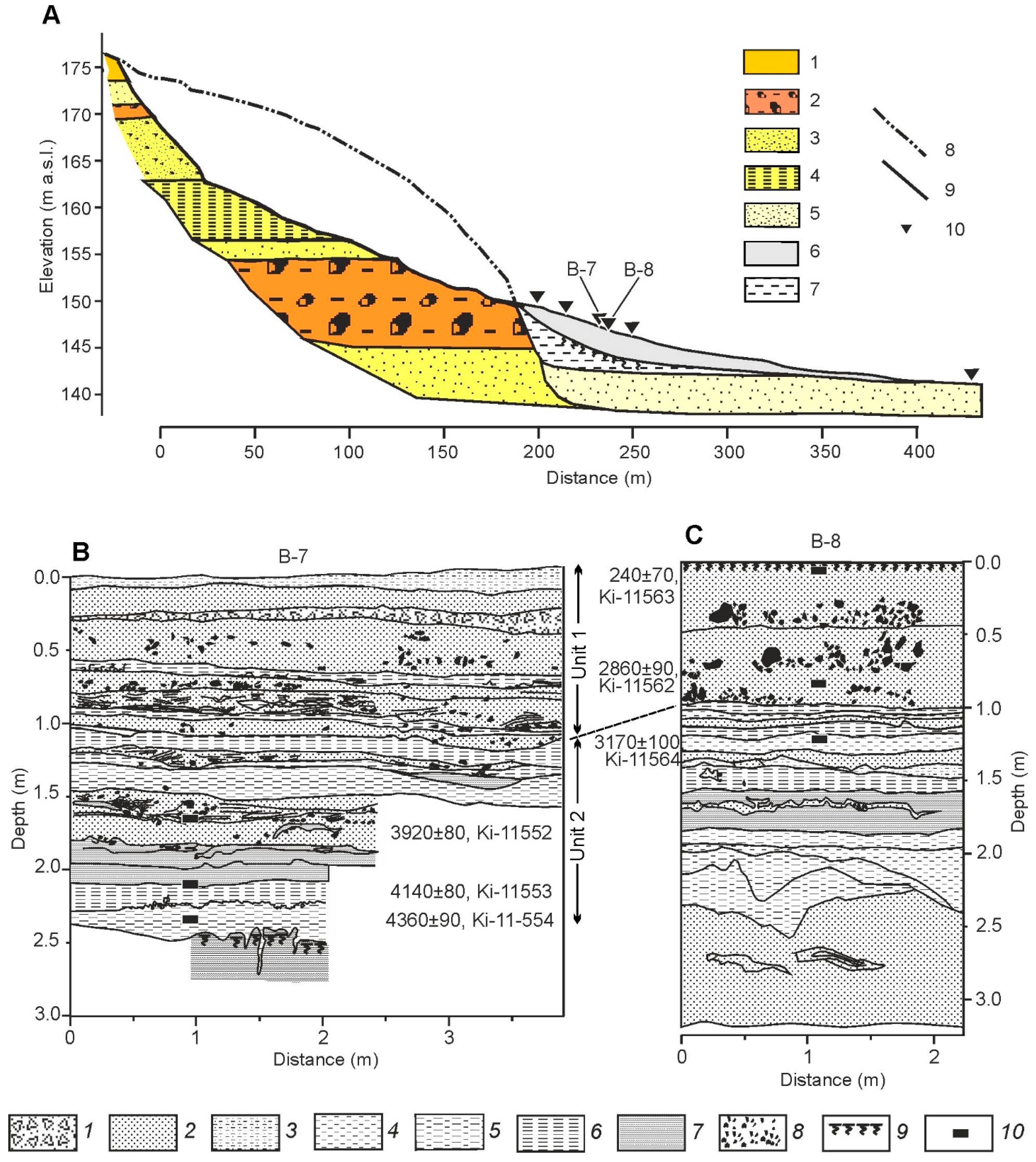
3.3. Gully Erosion at the Headwaters of the River Net

The Holocene stage of incision caused gully formation along the lozhbinas (see Section 3.2.1), as well as on the slopes of the valleys of the rivers and balkas. There are about 40 gullies within the studied key area; 19 of these gullies have been explored [19].
The history of the development of gullies is recorded in the structure of correlative deposits eroded and carried out during their incision and deposited in their fans. The fans of the majority of the 19 gullies are partly destroyed by the river or creek flow erosion (see Table 2 in [19]). The best preserved correlative sediments were found in the accumulative fan of the Volchiy Gully with the volume of about 48% of that of the gully. This gully is a typical example of the gully cut into a steep river valley slope.
The Volchiy gully is situated on the left side of the Protva River valley. It cuts into a steep (7–10°) and high (20–22 m) slope of the valley. The gully system consists of the main trunk and three heads. Along its entire length, the gully has clear-cut edges and straight slopes with a steepness from 20° to 45–50°. In the upper part, the gully cuts through a thin layer of mantle loams, then through glaciofluvial sands, and a thin sandy moraine layer (Figure 13). Lower, the gully cuts through 15 m thick easily erodible glaciofluvial sands and silts. The underlying moraine layer—heavy loam with coarse sand and gravel—is cut by the gully in its lowermost part. The bottom of the gully forms several steps 15–20 m long, but in general, its longitudinal profile has a concave shape. The longitudinal profile of the gully is fully developed and for almost four decades of observations did not show any erosion activity.
The sediment fan of the gully has an arched front edge and maximum width and length of about 200 m. Fan deposits with complicated structure can be generally divided into two units. The upper unit, wedging out to the edges of the fan, is represented by sand with gravel and small boulders (Figure 13B,C). The lower unit is composed of interlayers of sand, silt and clay.
The fan lies on the loam deposits washed from the valley slope. On the surface of these loams a soil with a well-differentiated profile is developed. At the contact between the sediments washed out from the gully and the buried soil, numerous large pieces of charcoal were found both in the gully deposits and in the buried soil. The 14C dates obtained from the charcoals (4140 ± 80 and 4360 ± 90) make it possible to determine the time when the fires occurred. Several more radiocarbon dates of the fan deposits (Figure 13A) allowed us to trace the history of gully development. The gully was initially formed between 4.5 and 5 cal ka BP, when a forest fire or a series of fires destroyed the vegetation on the slope and thus triggered gully erosion. The development of the gully probably began in the middle part of the slope composed of the most easily erodible sandy and silty sediments. The first phase of the growth of the gully system finished about 2800–3200 years ago. During this phase, main part of erosional volume of the gully and the lower unit of deposits were formed. The second phase was the formation of the upper unit of sandy deposits with the inclusion of gravel, small boulders and rounded pieces of glacial till indicating erosion of moraine and coarse glaciofluvial sediments. The decrease in the accumulation rate and long-term stability of the fan after depositing of Unit 1 are indicated by a relatively old age of soil on the surface of the fan—about 240 years.

4. Discussion

Most researchers agree that both the formation and major erosion phases in dry valleys (balkas) and old ravines in the Russian Plain occurred within cold phases of the glacial-interglacial climatic rhythms, while during the interglacials the sides and bottoms of small erosion forms were stabilized by soil cover [8,34,35,36,37,38,39,40,41,42,43,44,45]. Pre-Holocene rise of erosion and subsequent stabilization after the onset of the Holocene has also been reported from different regions of Europe. In Southern England, activation of erosion and significant deepening of dry valleys occurred during the Younger Dryas cold event [46]. The marsh soils formed on the adjacent plain under stable conditions in the Allerød, were then buried under sediments of alluvial fans. In the Holocene, dry valley bottoms were stabilized by soils. In southeast England, a phase of sheetwash erosion was found to have occurred between 21 and 18 ka, but the major cutting of a dry valley occurred not later than ca. 88 ka (MIS 5a) [47]. Active erosion in small dry valleys during different cold phases of the last glacial-interglacial climate rhythm was revealed also in other regions of Britain, such as Southern Pennines [48] and southwest England [49]. In Belgium, large old gullies have started to form under pre-Holocene periglacial conditions [50]. Two main phases of fluvial incision of a creuse—a ravine-like landform of kilometric length that cuts the bottom of a small elementary valley—were found in the north of France: the ravine was formed in periglacial environment before ca. 30 ka and underwent another incision phase in the Late Glacial [51]. In the Paris Basin, most gullies were formed under periglacial climate, and fluvial incisions that have begun since the Subboreal, are attributed to tectonic reactivation and human impact [52]. In Ukraine, the major incision of the fluvial network occurred in the end of the MIS 6 glacial epoch, and the other phase of balkas deepening is dated to the Late Glacial [53]. In the marginal zone of the Last (MIS 2) Glaciation in the Baltic region, the activation of the linear growth of drainage network occurred at the glacial/interglacial boundary [54].
The results of this study of the region glaciated in MIS 6 also support the above point of view. In the studied area, the activation of the linear growth of the upper reaches of the fluvial network occurred at the end of the MIS 6 glaciation. This activation of erosion processes was very extensive, so that the heads of the gullies nearly reached the local water divides, as in Senokosnaya Lozhbina. During the optimum of the following Interglacial (MIS 5e), the linear erosion at the upper reaches of the fluvial systems changed to deposition due to surface runoff decrease. Steep walls of the gullies were flattened by slow slope processes and the gullies were transformed into more gentle features—balkas. Peat accumulation took place in the mires, which occupied then the depressions at the heads of these balkas. The cooling in MIS 5d-a caused a new intensification of sedimentation, at least at the heads of the erosion features.
Fluvial sediments of MIS 4 to MIS 2 age were not found in the balkas and lozhbinas in the studied territory, though presumably at that period, slope deposits and mantle loams must have filled the erosion features, at least partly [37,40]. It is most possible that these sediments were carried out of small erosional forms during the next stage of incision in the Late Glacial [8,45]. The erosion event at the end of MIS 2 was less powerful than the one at the end of MIS 6. As the gullies formed at the end of MIS 2 were shorter than the MIS 6 gullies, the older infill deposits were partly preserved near the watersheds. Therefore, in the smaller erosion forms, such as Kamennaya and Senokosnaya lozhbinas, the deposits of the time interval from MIS 5 to MIS 2 were not washed away entirely during the erosion event at the end of MIS 2, although they were washed away from the larger erosion forms, such as the Cholokhovskaya and Yazvitsa balkas. Therefore, in the two latest glacial-interglacial rhythms, deepening of small valleys occurred in the very end of the cold parts of the rhythms, in both the MIS 6 and MIS 2–4 glaciations during the transitional phases to the interglacial epochs. The bottoms of the balkas were stable during the interglacial epochs.
Different opinions exist on the mechanism of dry valley deepening in periglacial areas. Some researchers believe that the activation of linear erosion in the bottoms of small dry valleys occurred because of the runoff increase due to the lowering of surface permeability under permafrost conditions [34,35,40,41]. The alternative view accounts for the increase of surface erodibility due to the lower vegetation cover density under drying climate [37,38,39]. Our results confirm the first point of view but adjusted for the fact that the runoff could have increased not only due to the influence of permafrost, but also due to an increase in the amount of winter precipitation. The studies of the morphology of the river paleochannels clearly indicate a stage of high runoff at the end of MIS 2 [55,56,57,58]. In the research area, the maximum river runoff depth in the late MIS 2 can be estimated with the data on the large paleochannel of the Protva River [59]. The bankfull discharge close to the mean maximum discharge with the return period about once in two years, estimated with Chezy–Manning formula from the morphometry of the large paleochannel, was 1600 m3 s–1 in the basin area of 1800 km2. Therefore, the daily river runoff depth for a maximum of a mean flood was 77 mm. Recalculation into mean maximum runoff depth with a 100-year return period using the modern relationship for the Protva River gives an estimate of 210 mm, while the current runoff depth at the flood maximum is estimated at 20 mm [13].
In the Holocene, the major erosion phase occurred around 5,000 years ago. All the major post-Pleistocene gullies were formed at that time [19,60]. These gullies are of natural origin, since, according to the archaeological data, intensive land use in this area began much later [61]. Numerous finds of charcoal in sediments inside these gullies indicate that the intensification of gully erosion was triggered by the natural forest fires.
A comparison of the evolution of the upper reaches of the fluvial systems in the areas of the East European Plain covered by the continental icesheet during MIS 6 and those which remained non-glaciated [8] shows both similarities and differences (Figure 14). General sequences of the major erosion events in the two areas are similar. This similarity is associated with the common course of hydroclimatic changes over the entire East European Plain during two glacial–interglacial cycles, covering the time interval from MIS 6 to the Holocene (MIS 1). Three main events of high surface runoff are detected from the relief and lithology of the fluvial systems in the East European Plain: (1) at the end of MIS 6 [8,62], (2) at the end of MIS 2 [57,63,64] and (3) in the Late Holocene [65]. All of these events caused intensive erosion at the upper reaches of the fluvial systems both in the glaciated and non-glaciated parts of the plain. One more event of high runoff and erosion, corresponding to MIS 3, so far has been detected only in the river valleys [57,63].
The main differences lie in the types of erosional landforms characteristic of certain stages of the climatic macrocycle, and in their further evolution. In the regions glaciated during MIS 6, fresh glacial, glaciofluvial and glaciolacustrine relief features and deposits abounded after the icesheet retreat. At the end of the MIS 6 glaciation, the territory was a so-called primary moraine plain, which had not yet been transformed by fluvial processes. Gentle hills were composed of heavy loams with gravel and boulders—the MIS 6 moraine. Meltwater channels between these hills were filled by sandy deposits underlain by moraine. Therefore, the heterogeneity in relief and lithology within the glaciated area was in general much higher than in the regions south of the MIS 6 glaciation limit. The onset of regional erosion events was caused by the initiation of the incision of small erosional forms, which was determined by a favorable combination of the surface runoff, the catchment area, the initial inclination of the slopes, the lithological composition of these slopes and the properties of vegetation.
The combinations of these factors were different for different erosion features, causing the heterogeneity in their further evolution. For example, of two small erosional forms with gentle slopes developed in sandy sediments, during the erosion event at the end of MIS 6, linear incision took place in the Senokosnaya Lozhbina, but did not start in the Kamennaya Lozhbina, presumably due to differences in the initial inclination of the slopes.
High surface runoff at the end of MIS 6 and MIS 2 glacial epochs brought about formation of such linear erosion features as the Yazvitsa and Cholokhovskaya balkas developed in moraine loams. High water discharges and large critical velocities of erosion initiation in hard sediments caused high inclinations of the longitudinal profiles of these erosion forms. Therefore, the subsequent deposition could have occurred only at the very heads of these balkas; consequently, there are no deposits older than the Holocene in their main valleys.
We compared the longitudinal profiles of balkas with similar basins, one from the extraglacial area (the Perepolye Balka described in [8]), and the others from the area glaciated in MIS 6 (Yazvitsa and Cholokhovskaya Balkas). To simplify the comparison, profiles were transformed to the unidimensional form (Figure 15). The comparison shows that the Yazvitsa and Cholokhovskaya balkas are much less incised than the Perepolye Balka. Cholokhovskaya Balka has a convex longitudinal profile, the Yazvitsa Balka is nearly straight and the Perepolye Balka has a concave profile. This difference is the result of stronger lithological control over erosion rates by MIS-6 moraine in the territory previously covered by the MIS 6 glaciation. The longitudinal profile of the gully Volchy, formed mostly in sands, is well developed and concave (Figure 15), despite the lesser duration of its formation.
Such relatively large erosional forms as balkas (small dry valleys) showed different reactions to climatic events of the Late Pleistocene—Holocene in glacial and extraglacial regions. In the MIS 6 glaciation area, most balkas have poorly developed convex longitudinal profiles. A general tendency of their development towards an equilibrium state was an incision. They reacted to climatic changes by stabilization during periods of relatively low runoff or by slow but unidirectional deepening into hard underlying ground (usually moraine deposits) during periods of increased runoff. Much older balkas in the extraglacial regions already had well-developed concave longitudinal profiles, and they responded more sensitively to climatic changes by deep incision during periods of increased runoff and by rapid aggradation followed by stabilization during periods of decreasing runoff. As a result, the structure of the balkas in these two areas differs, which makes it possible to distinguish the Northern (MIS 6 glaciation area) and Southern (non-glacial areas) types of balkas (Figure 16).
To a significant increase in surface runoff in the end MIS 6 and MIS 2, which manifested itself in both areas, the northern-type balkas on moraine reacted by deepening and destruction of all previously accumulated deposits. In the Early and Middle Holocene, these balkas were subjected to horizontal erosion by temporary streams with the accumulation of a small thickness of alluvium (Figure 16A). The increase in water runoff in the Late Holocene was expressed in the formation of new incisions. Therefore, these balkas are characterized by a single but heterochronous erosion surface. Southern-type balkas, as shown in [8], reacted to the same events of increase in water runoff with a significant (10–15 m) deepening, which, however, might not destroy the infilling of older incisions where they were deeper than the new ones (Figure 16B). The periods of sharp decrease in runoff were expressed in the rapid aggradation and conservation of erosion surface. Therefore, the remnants of erosion surfaces of different age and infilling deposits clearly indicate the complicated evolution of the southern-type balkas. Small erosion forms, incised into sands in the northern area, also can conserve deposits older than the Holocene, mostly in their upper reaches.

5. Conclusions

The evolution of the upper reaches of the fluvial systems in the part of the East European Plain occupied by the continental ice sheet in MIS 6 had both similarities and differences with respect to the development of similar erosional features in the more southern part of the plain, which was not covered with this glaciation.
The main similarity is due to the general changes in air temperature and humidity during two glacial–interglacial cycles, covering the time interval from MIS 6 to the Holocene (MIS 1). The phases of air temperature and humidity oscillations were asynchronous. Their superposition and interaction led to the formation of quasiperiodic fluctuations of surface and river runoff and water discharge. At least three main events of high surface runoff caused intensive erosion at the upper reaches of the fluvial systems both in the glaciated and non-glaciated parts of the plain: (1) at the end of MIS 6, (2) at the end of MIS 2 and (3) in the Late Holocene.
The differences between glaciated and non-glaciated areas in this respect are also quite substantial. The initial heterogeneity of fresh glacial and glaciofluvial relief and deposits within the territory covered by MIS 6 continental icesheet caused more scatter in the erosion–accumulation processes and episodes of high surface runoff. The diversity of catchment areas, initial slope inclinations, vegetation patterns and sediment properties causing their resistance to erosion led to greater differences in the relief features and evolution of the upper reaches of the fluvial systems within the MIS 6 glaciation area compared to more uniform landscape conditions in the extraglacial regions.
Erosion of initial slopes composed of sands during the events of high surface runoff caused forming of the erosion features with gentle longitudinal profiles and made possible the subsequent accumulation of sediments in such valleys after the period of high surface runoff ended. Erosion of steep initial slopes composed of moraine also occurred during the high surface runoff events. Steep longitudinal profiles of the erosion features formed on the glacial till brought about further development of erosion and fast transportation of sediments in such valleys, not only during high surface runoff events, but also in the medium runoff periods. In balkas in the MIS 6 glaciation area (northern-type of balkas) sequential erosion surfaces and infilling deposits were not preserved, unlike in the balkas of non-glaciated areas with their buried incisions 10–15 m deep filled with the Early Valdaian sediments (MIS 4) and Early to Middle Holocene sediments (southern-type of balkas).

Author Contributions

Conceptualization, A.P., O.B. and A.S.; methodology, A.P., O.B., V.B., Y.B., E.E., Y.F., E.S. and A.S.; investigation, A.P., O.B., V.B., Y.B., E.E., Y.F., E.S. and A.S.; writing—original draft preparation A.P., O.B. and A.S.; writing—review and editing, A.P., O.B. and A.S. All authors have read and agreed to the published version of the manuscript.

Funding

This research was funded by the Russian Science Foundation Project 17-17-01289 (palaeohydrological estimations in the late MIS 6—MIS 2 epochs) for Andrey Panin, by the State Task no. FMGE-2019-0005, Institute of Geography RAS for Olga Borisova, by the State Task no. AAAA-A16-116032810089-5, Faculty of Geography MSU for Yury Belyaev, Ekaterina Eremenko, Yulia Fuzeina and Elena Sheremetskaya and by the State Task 1.13 no. 121051100166-4, Faculty of Geography MSU for Vladimir Belyaev and Aleksey Sidorchuk.

Institutional Review Board Statement

Not applicable.

Informed Consent Statement

Not applicable.

Data Availability Statement

Not applicable.

Conflicts of Interest

The authors declare no conflict of interest.

References

  1. Macklin, M.G.; Lewin, J.; Woodward, J.C. The fluvial record of climate change. Phil. Trans. R. Soc. A 2012, 370, 2143–2172. [Google Scholar] [CrossRef] [PubMed]
  2. Spiridonov, A.I. Geomorphology of the European Part of the USSR (Geomorfologiya Yevropeyskoy Chasti SSSR); Vysshaya Shkola: Moscow, Russia, 1978; p. 333. (In Russian) [Google Scholar]
  3. Moskalewicz, D.; Sokołowski, R.J.; Fedorowicz, S. River response to climate and sea level changes during the Late Saalian/Early Eemian in northern Poland—A case study of meandering river deposits in the Chłapowo cliff section. Geologos 2016, 22, 1–14. [Google Scholar] [CrossRef] [Green Version]
  4. Veldkamp, A.; Van den Berg, M.W.; Van Dijke, J.J.; Van den Berg van Saparoea, R.M. Reconstructing Late Quaternary fluvial process controls in the upper Aller Valley (North Germany) by means of numerical modeling. Neth. J. Geosci. 2002, 81, 375–388. [Google Scholar] [CrossRef] [Green Version]
  5. Kaiser, K.; Lorenz, S.; Germer, S.; Juschus, O.; Küster, M.; Libra, J.; Bens, O.; Hüttl, R.F. Late Quaternary evolution of rivers, lakes and peatlands in northeast germany reflecting past climatic and human impact—An overview. Quat. Sci. J. 2012, 61, 2. [Google Scholar] [CrossRef] [Green Version]
  6. Curry, B.B.; Baker, R.G. Palaeohydrology, vegetation, and climate since the late Illinois Episode (~130 ka) in south-central Illinois. Palaeogeogr. Palaeoclim. Palaeoecol. 2000, 155, 59–81. [Google Scholar] [CrossRef]
  7. Sidorchuk, A.Y. Fractal geometry of the river network. Geomorfologiya 2014, 1, 3–14. (In Russian) [Google Scholar] [CrossRef]
  8. Panin, A.; Borisova, O.; Konstantinov, E.; Belyaev, Y.; Eremenko, E.; Zakharov, A.; Sidorchuk, A. The late quaternary evolution of the upper reaches of fluvial systems in the southern East European Plain. Quaternary 2020, 3, 31. [Google Scholar] [CrossRef]
  9. Petrov, O.V.; Morozov, A.F. (Eds.) Map of Quaternary Formations on a Scale of 1:2,500,000 of the Territory of the Russian Federation. In Explanatory Note (Karta Chetvertichnykh Obrazovaniy Masshtaba 1:2,500,000 Territorii Rossiyskoy Federatsii. Poyasnitel’naya Zapiska); Ministry of Natural Resources of Russia, Rosnedra, FSUE”VSEGEI”, FSUE “VNIIOkeangeologiya”: Sankt-Petersburg, Russia, 2010; p. 220. (In Russian) [Google Scholar]
  10. Velichko, A.A.; Faustova, M.A.; Pisareva, V.V.; Gribchenko, Y.N.; Sudakova, N.G.; Lavrentiev, N.V. Glaciations of the East European Plain: Distribution and chronology. In Quaternary Glaciations—Extent and Chronology. A Closer Look; Ehlers, J., Gibbard, P.L., Hughes, P.D., Eds.; Elsevier: Amsterdam, The Netherlands, 2011; pp. 337–359. [Google Scholar]
  11. Astakhov, V. Ice Margins of Northern Russia Revisited. In Quaternary Glaciations—Extent and Chronology. A Closer Look; Ehlers, J., Gibbard, P.L., Hughes, P.D., Eds.; Elsevier: Amsterdam, The Netherlands, 2011; pp. 323–336. [Google Scholar]
  12. Karabanov, A.K.; Matveyev, A.V. The Pleistocene Glaciations in Belarus. In Quaternary Glaciations—Extent and Chronology. A Closer Look; Ehlers, J., Gibbard, P.L., Hughes, P.D., Eds.; Elsevier: Amsterdam, The Netherlands, 2011; pp. 29–35. [Google Scholar]
  13. Rychagov, G.I. (Ed.) Basic Geographical Field Course in the Moscow Region. (Obshchegeograficheskaya Praktika v Podmoskov’ye); Faculty of Geography, Moscow State University: Moscow, Russia, 2007; p. 360. (In Russian) [Google Scholar]
  14. Nesmelova, Y.I. Microclimate of the Satino Test. Site (Mikroklimat Satinskogo Poligona); Moscow University Press: Moscow, Russia, 1992; p. 74. (In Russian) [Google Scholar]
  15. Gribova, S.A.; Isachenko, T.I.; Lavrenko, E.M. (Eds.) Vegetation of the European Part of the USSR (Rastitel’nost’ Yevropeyskoy Chasti SSSR); Nauka: Leningrad, Russia, 1980; p. 429. (In Russian) [Google Scholar]
  16. Rychagov, G.I.; Antonov, S.I. (Eds.) Structure and History of the Development of the Protva River Valley (Stroyeniye i Istoriya Razvitiya Doliny Reki Protvy); Moscow University Press: Moscow, Russia, 1996; p. 129. (In Russian) [Google Scholar]
  17. Soil Science Division Staff. Soil Survey Manual. USDA Handbook 18; Ditzler, C., Scheffe, K., Monger, H.C., Eds.; Government Printing Office: Washington, DC, USA, 2017.
  18. List of Labs in Agreement. Available online: https://radiocarbon.webhost.uits.arizona.edu/node/11 (accessed on 5 January 2022).
  19. Panin, A.V.; Fuzeina, J.N.; Belyaev, V.R. Long-term development of Holocene and Pleistocene gullies in the Protva River basin, Central Russia. Geomorphology 2009, 108, 71–91. [Google Scholar] [CrossRef]
  20. Moore, P.D.; Webb, J.A.; Collinson, M.E. Pollen Analysis; Blackwell: Oxford, UK, 1991; p. 216. [Google Scholar]
  21. Grichuk, V.P. Fossil floras as the basis for the Quaternary stratigraphy. In Relief and Stratigraphy of the Quaternary Deposits in the North-Western Part of the Russian Plain (Rel’yef i Stratigrafiya Chetvertichnykh Otlozheniy Severo-Zapadnoy Chasti Russkoy Ravniny); Markov, K.K., Ed.; Izdatel’stvo AN SSSR: Moscow, Russia, 1961; pp. 25–71. (In Russian) [Google Scholar]
  22. Rychagov, G.I.; Antonov, S.I. (Eds.) Comprehensive Analysis of Quaternary Deposits of the Satinsky Training Range (Kompleksnyy Analiz Chetvertichnykh Otlozheniy Satinskogo Uchebnogo Poligona); Moscow State University: Moscow, Russia, 1992; p. 128. (In Russian) [Google Scholar]
  23. Karagodina, M.V.; Voskresenski, I.S.; Sidorchuk, A.Y. Geomorphological outline of the basin of the middle reaches of the Protva River. Vestnik Mosk. Un-ta Seriya 5 Geogr. 1970, 6, 93–96. (In Russian) [Google Scholar]
  24. Antonov, S.I.; Gunova, V.S.; Rychagov, G.I.; Sudakova, N.G. The Protva River valley evolution in the Late Neopleistocene. Vestnik Mosk. Un-ta Seriya 5 Geogr. 2019, 4, 88–99. (In Russian) [Google Scholar]
  25. Eremenko, E.A.; Karevskaya, I.A.; Panin, A.V. Postglacial transformation of fluvioglacial troughs in the marginal zone of the Moscovian glaciation. Izv. Akad. Nauk Ser. Geogr. 2010, 2, 56–70. (In Russian) [Google Scholar]
  26. Tyuremnov, S.N.; Vinogradova, E.A. Types of interglacial peatlands of the Moscow region. Bull. Kom. Izuch. Chetv. Per. 1973, 40, 3–21. (In Russian) [Google Scholar]
  27. Borisova, O.K. Vegetation and climate changes at the Eemian/Weichselian transition: New palynological data from Central Russian Plain. Pol. Geol. Inst. Spec. Pap. 2005, 16, 9–17. [Google Scholar]
  28. Velichko, A.A.; Borisova, O.K.; Gurtovaya, Y.Y.; Zelikson, E.M. Climatic rhythm of the last interglacial in Northern Eurasia. Quat. Int. 1991, 10–12, 191–213. [Google Scholar] [CrossRef] [Green Version]
  29. Borisova, O.K.; Novenko, E.Y.; Velichko, A.A.; Kremenetski, K.V.; Junge, F.W.; Boettger, T. Vegetation and climate changes during the Eemian and Early Weichselian in the Upper Volga region (Russia). Quat. Sci. Rev. 2007, 26, 2574–2585. [Google Scholar] [CrossRef]
  30. Zagwijn, W.H. An analysis of Eemian climate in western and central Europe. Quat. Sci. Rev. 1996, 15, 451–469. [Google Scholar] [CrossRef]
  31. Kukla, G.J.; Bender, M.L.; de Beaulieu, J.L.; Bond, G.; Broecker, W.S.; Cleveringa, P.; Gavin, J.E.; Herbert, T.D.; Imbrie, J.; Jouzel, J.; et al. Last interglacial climates. Quat. Res. 2002, 58, 2–13. [Google Scholar] [CrossRef]
  32. OxCal. Available online: https://c14.arch.ox.ac.uk/oxcal.html (accessed on 5 January 2022).
  33. Rychagov, G.I.; Aleshinskaya, Z.V.; Antonov, S.I.; Skornyakova, L.A. New sections of the Mikulino deposits in the center of the Russian Plain. In Quaternary Period. Stratigraphy (Chetvertichnyy Period. Stratigrafiya); Nauka (Publ.): Moscow, Russia, 1989; pp. 35–42. (In Russian) [Google Scholar]
  34. Dedkov, A.P. On the Issue of Slope Accumulation in the Periglacial Conditions of the Pleistocene. In Paleogeography and Periglacial Phenomena of the Pleistocene (K Voprosu o Sklonovoy Akkumulyatsii v Periglyatsial’nykh Usloviyakh Pleystotsena. Paleogeografiya i Periglyatsial’nyye Yavleniya Pleystotsena; Nauka: Moscow, Russia, 1975; p. 57. (In Russian) [Google Scholar]
  35. Aseev, A.A.; Dedkov, A.P. Climate Change and Relief Development/Climate, Relief and Human Activity (Smena Klimatov i Razvitiye Rel’yefa/Klimat, Rel’yef i Deyatel’nost’ Cheloveka); Nauka: Moscow, Russia, 1981; pp. 118–128. [Google Scholar]
  36. Khrutsky, S.V.; Kostsova, E.V. Varieties of slopes depending on their formation in interglacial and periglacial conditions. In Climate, Relief and Human Activity (Klimat, Rel’yef i Deyatel’nost’ Cheloveka); Nauka: Moscow, Russia, 1981; pp. 148–155. (In Russian) [Google Scholar]
  37. Khrutsky, S.V. Problems of the formation of beams in connection with climate change in the Pleistocene. Geomorfologiya 1985, 1, 17–21. (In Russian) [Google Scholar]
  38. Khrutsky, S.V.; Semenov, O.P.; Kostsova, E.V. Processes of relief formation in the Pleistocene periglacials and modern forms of erosional relief. Geomorfologiya 1998, 3, 104–108. (In Russian) [Google Scholar]
  39. Khrutsky, S.V.; Semenov, O.P.; Kostsova, E.V. Forms of the primary hydrographic network, their genesis and typification problems. Geomorfologiya 1998, 4, 85–91. (In Russian) [Google Scholar]
  40. Butakov, G.P. Pleistocene Periglacial in the East of the Russian Plain (Pleystotsenovyy Periglyatsial na Vostoke Russkoy Ravniny); Kazan University Publicatrion: Kazan, Russia, 1986; p. 143. (In Russian) [Google Scholar]
  41. Butakov, G.P.; Ermolaev, O.P.; Kovalchuk, I.P.; Litvin, L.F.; Mozzherin, V.I.; Sidorchuk, A.Y.; Chernov, A.V. Forms of manifestation of erosion-accumulative processes in small river catchments. In Erosion and Channel Processes (Erozionnyye i Ruslovyye Protsessy); Chalov, R.S., Molchak, Y.A., Eds.; Lutsk State Pedagogic Institute: Lutsk, Ukraine, 1991; pp. 19–42. (In Russian) [Google Scholar]
  42. Sycheva, S.A. Evolution of the Moscow-Valdai paleo-incisions on the interfluves of the Middle Russian Upland. Geomorfologiya 2003, 3, 76–91. (In Russian) [Google Scholar]
  43. Sycheva, S.A. Evolution of erosional paleoforms in the “glaciation-interglacial” climatic cycle. In New and Traditional Ideas in Geomorphology. Proc. Conf. “V Shchukin Readings”. (Novyye i Traditsionnyye Idei v Geomorfologii. Trudy Konferentsii “V Shchukinskiye Chteniya”); Moscow State University, Geographical Faculty: Moscow, Russia, 2005; pp. 169–173. (In Russian) [Google Scholar]
  44. Belyaev, Y.R.; Grigorieva, T.M.; Sycheva, S.A.; Sheremetskaya, E.D. Development of the dry valley upper reaches in the central Middle Russian Upland at the end of the Middle-Late Pleistocene. Geomorfologiya 2008, 1, 43–55. (In Russian) [Google Scholar]
  45. Panin, A.V. Development of the ravine subsystem of erosion-channel systems in the Late Pleistocene—Holocene. In Erosional-Channel Systems (Erosionno-Ruslovye Sistemy); Chalov, R.S., Ed.; INFRA: Moscow, Russia, 2017; pp. 512–527. (In Russian) [Google Scholar]
  46. Kerney, M.P.; Brown, E.H.; Chandler, T.J. The late-glacial and post-glacial history of the chalk escarpment near Brook, Kent. Philos. Trans. R. Soc. Lond. Ser. B 1963, 248, 135–204. [Google Scholar]
  47. Murton, J.B.; Bateman, M.D.; Baker, C.A.; Knox, R.; Whiteman, C.A. The Devensian periglacial record on Thanet, Kent, UK. Permafr. Periglac. Process. 2003, 14, 217–246. [Google Scholar] [CrossRef]
  48. Warwick, G.T. Dry valleys in the southern Pennines. Erdkunde 1964, 18, 116–123. [Google Scholar] [CrossRef]
  49. Gardiner, V. Channel networks: Progress in the study of spatial and temporal variations of drainage density. In Changing River Channels; Gurnell, A., Petts, G., Eds.; Wiley: Chichester, UK, 1995; pp. 65–85. [Google Scholar]
  50. Langohr, R.; Sanders, J. The Belgium Loess belt in the last 20,000 years: Evolution of soils and relief in the Zonien Forest. In Soils and Quaternary Landscape Evolution; Boardman, J., Ed.; Wiley: Chichester, UK, 1985; pp. 359–371. [Google Scholar]
  51. Lahousse, P.; Pierre, G.; Salvador, P.G. Contribution à la connaissance des vallons élémentaires du Nord de la France: l’exemple de la creuse des Fossés (Authieule, Plateau Picard). Quaternaire 2003, 14, 189–196. [Google Scholar] [CrossRef]
  52. Larue, J.P. The status of ravine-like incisions in the dry valleys of the Pays de Thelle (Paris basin, France). Geomorphology 2005, 68, 242–256. [Google Scholar] [CrossRef]
  53. Matoshko, A.V. Balkas—A new look at a common landform of the East European Plain, from a Quaternary perspective. Earth Surf. Process. Landf. 2012, 37, 1489–1500. [Google Scholar] [CrossRef]
  54. Basalikas, A.B.; Shvyadas, K.I. Phase character of the periglacial transformation of the relief of lakeless hilly-moraine uplands. In Climate, Relief and Human Activity (Klimat, Rel’yef i Deyatel’nost’ Cheloveka); Nauka: Moscow, Russia, 1981; pp. 155–163. (In Russian) [Google Scholar]
  55. Sidorchuk, A.; Borisova, O.; Panin, A. Fluvial response to the late Valdai/Holocene environmental change on the East European Plain. Glob. Planet. Chang. 2001, 28, 303–318. [Google Scholar] [CrossRef]
  56. Vandenberghe, J.; Sidorchuk, A. Large palaeomeanders in Europe: Distribution, formation process, age, environments and significance. In Palaeohydrology. Geography of the Physical Environment; Herget, J., Fontana, A., Eds.; Springer Nature: Cham, Switzerland, 2019; Chapter 9; pp. 169–186. [Google Scholar]
  57. Starkel, L.; Michczyńska, D.J.; Gębica, P.; Kiss, T.; Panin, A.; Perşoiu, I. Climatic fluctuations reflected in the evolution of fluvial systems of Central-Eastern Europe (60–8 ka cal BP). Q. Int. 2015, 388, 97–118. [Google Scholar] [CrossRef]
  58. Sidorchuk, A.Y.; Ukraintsev, V.Y.; Panin, A.V. Estimating annual Volga runoff by data on the size of paleochannels. Water Resour. 2021, 48, 864–876. [Google Scholar] [CrossRef]
  59. Sidorchuk, A.Y.; Panin, A.V.; Borisova, O.K. Morphology of river channels and surface runoff in the Volga River basin (East European Plain) during the Late Glacial period. Geomorphology 2009, 113, 137–157. [Google Scholar] [CrossRef]
  60. Panin, A.V.; Matlakhova, E.Y.; Belyaev, Y.R.; Buylaert, J.P.; Dubis, L.F.; Murray, A.S.; Pakhomova, O.M.; Selezneva, E.V.; Filippov, V.V. Sedimentation and formation of terraces in the river valleys of the center of the Russian Plain in the second half of the Late Pleistocene. Bull. Kom. Izuch. Chetv. Per. 2011, 71, 47–74. (In Russian) [Google Scholar]
  61. Kashkin, A.V.; Krasnov, Y.A.; Massalitina, G.A.; Proshkin, O.L.; Smirnov, A.S.; Sorokin, A.N.; Frolov, A.S. Archaeological Map of Russia. Kaluga Region. (Arkheologicheskaya Karta Rossii. Kaluzhskaya Oblast’), 2nd ed.; Institute of Archaeology RAS: Moscow, Russia, 2006; p. 310. (In Russian) [Google Scholar]
  62. Sycheva, S.; Frechen, M.; Terhorst, B.; Sedov, S.; Khokhlova, O. Pedostratigraphy and chronology of the Late Pleistocene for the extra glacial area in the Central Russian Upland (reference section Aleksandrov quarry). Catena 2020, 194, 104689. [Google Scholar] [CrossRef]
  63. Panin, A.; Adamiec, G.; Buylaert, J.-P.; Matlakhova, E.; Moska, P.; Novenko, E. Two Late Pleistocene climate-driven incision/aggradation rhythms in the middle Dnieper River basin, west-central Russian Plain. Quat. Sci. Rev. 2017, 166, 266–288. [Google Scholar] [CrossRef] [Green Version]
  64. Panin, A.; Matlakhova, E. Fluvial chronology in the East European Plain over the last 20 ka and its palaeohydrological implications. Catena 2015, 130, 46–61. [Google Scholar] [CrossRef]
  65. Panin, A.V.; Adamiec, G.; Arslanov, K.A.; Bronnikova, M.A.; Filippov, V.V.; Sheremetskaya, E.D.; Zaretskaya, N.E.; Zazovskaya, E.P. Absolute chronology of fluvial events in the Upper Dnieper river system and its palaeogeographic implications. Geochronometria 2014, 41, 278–293. [Google Scholar] [CrossRef] [Green Version]
  66. Lisiecki, L.E.; Raymo, M.E. A Pliocene-Pleistocene stack of 57 globally distributed benthic d18O records. Paleoceanography 2005, 20, PA1003. [Google Scholar] [CrossRef] [Green Version]
Figure 1. On the left: southeastern boundaries of MIS 6 (Moscovian) icesheet (red line) and MIS 2 (Late Valdaian) icesheet (black line) on the East European Plain (adapted from [9]). The asterisk indicates the position of the key area. On the right is an image of the key area from Google Earth.
Quaternary 05 00013 g001
Figure 2. Geomorphological structure of the key area in the Protva River basin. The topography is from Lidar DEM, the southern part is from the topographic map. The numbers indicate positions of the gullies: 1—Uzkiy; 2—Kamenniy; 3—Senokosniy; 4—Volchiy. The dotted box corresponds to the territory in Figure 3.
Quaternary 05 00013 g002
Figure 4. The relief of the SEFs of type 1: Kamennaya (A) and Senokosnaya (B). Keys: 1—interfluves, 2—meltwater channels, 3—gullies, 4—river floodplain, 5—waterlogged depressions, 6—fans of the gullies, 7—trench, 8—boreholes.
Quaternary 05 00013 g004
Figure 5. The longitudinal profile of the Uzkiy Gully. Keys: 1—MIS 6 moraine, 2—glaciofluvial sand, 3—lacustrine silt, 4—the Holocene gully infill, 5—initial slope; 6—gully terrace surface, 7—gully bed, 8—cross-sections with cores; 9—14C dates.
Quaternary 05 00013 g005
Figure 6. The lithological structure of the Senokosnaya Lozhbina. Keys: 1—MIS 6 moraine, 2—glaciofluvial sand and gravel, 3—brown-grey loam, 4—peat, 5—slopewash sand and loam, 6—mantle loam, 7—boreholes.
Quaternary 05 00013 g006
Figure 7. The grain size distribution of different lithological units in the Senokosnaya Lozhbina.
Quaternary 05 00013 g007
Figure 8. The longitudinal profile of the Senokosniy Gully. Keys for the profile (A): 1—MIS 6 moraine, 2—glaciofluvial sand with gravel, 3—lacustrine silt, 4—Holocene deposits (sand and loam), 5—initial slope, 6—gully bed, 7—cross-sections. Keys for the pit (B) and core (C): 1—sand, 2—sandy loam, 3—loam, 4—clay, 5—buried soil, 7—14C samples.
Quaternary 05 00013 g008
Figure 9. Longitudinal profile of the Yazvitsa Balka. Keys: 1—MIS 6 moraine, 2—glaciofluvial sand, 3—Holocene sand and sand with gravel, 4—Holocene deposits of the balka terrace (sand and loam), 5—initial slope, 6—gully terrace surface, 7—gully bed, 8—cross-sections with cores.
Quaternary 05 00013 g009
Figure 10. Cross-sections of the Yazvitsa Balka. Keys: 1—till, 2—glaciofluvial sand, 3—loam. 4—silt, 5—sandy loam, 6—sand, 7—gravel, 8—pits and cores, 9—14C samples and dates.
Quaternary 05 00013 g010
Figure 11. Longitudinal profile of the Cholokhovskaya Balka. Keys: 1—MIS 6 moraine, 2—glaciofluvial or glaciolacustrine silt, 3—MIS 5e deposits, 4—the Holocene deposits (sand and loam), 5—initial slope, 6—gully terrace surface, 7—gully bed, 8—cross-sections with cores.
Quaternary 05 00013 g011
Figure 12. Keys: 1—clay, 2—heavy loam, 3—medium and light loam, 4—silt, 5—sandy loam, 6—mixed-grained sand, 7—boulder–pebble–gravelly mixture with sand filler, 8—boulder loam, 9—buried soil, 10—peat formation, 11—cores, 12—14C samples and dates.
Quaternary 05 00013 g012
Figure 13. The longitudinal profile of the Volchiy Gully and the structure of its fan. Keys for the profile (A): 1—mantle loams, 2—glacial till, 3—glaciofluvial sand, 4—glaciolacustrine silt, 5—the Protva River floodplain deposits (sand and loam), 6—gully fan deposits, 7—slopewash deposits, 8—initial slope, 9—gully bed, 10—pits. Keys for pits (B,C): 1—coarse sand with gravel and pebbles, 2—sand, 3—sandy loam, 4—light loam; 5—medium and heavy loam, 6—silt, 7—slopewash loam, 8—clusters of pebbles and gravel, 9—modern and buried soils; 10—14C samples.
Quaternary 05 00013 g013
Figure 14. A comparison of the evolution of the upper reaches of fluvial systems in the regions of the East European Plain glaciated and non-glaciated [8] during MIS 6 (=Moscovian/Late Saalian glaciation). Keys: 1—predominant accumulation in the small erosional forms, 2—soil formation, 3—erosion and incision, 4—development of meltwater channels, 5—accumulation of glaciofluvial deposits, 6—local peat accumulation in the balkas, 7—predominant transport of sediments [10,66].
Quaternary 05 00013 g014
Figure 15. Comparison of the longitudinal profiles of the erosional forms, situated in the extraglacial part of the East European Plain (the Perepolye Balka) and in its part glaciated during MIS 6 (Yazvitsa and Cholokhovskaya Balkas, Volchiy gully). Keys: 1—initial slope, 2—gully bed.
Quaternary 05 00013 g015
Figure 16. Typical cross-sections of the northern (A) and southern (B) types of dry valleys (balkas) in the East European Plain. Keys: 1–5—depositional series: 1—the Last Interglacial deposits and paleosoil (MIS 5e), 2—the Early Valdaian sediments (MIS 4), 3—the Late Glacial (late MIS 2), 4—the Early and Middle Holocene and 5—the Late Holocene sediments; 6–9—the main erosion surfaces (ES): 6—heterochronous ES (from MIS 6 to the Holocene), 7—ES of the end of MIS 6, 8—ES of the end of MIS 2, 9—the Holocene ES.
Quaternary 05 00013 g016
Publisher’s Note: MDPI stays neutral with regard to jurisdictional claims in published maps and institutional affiliations.

