

Mid-Late Quaternary Fluvial Archives near the Margin of the MIS 12 Glaciation in Southern East Anglia, UK: Amalgamation of Multi-Disciplinary and Citizen-Science Data Sources
 , , , , , ,
Abstract
:1. Introduction


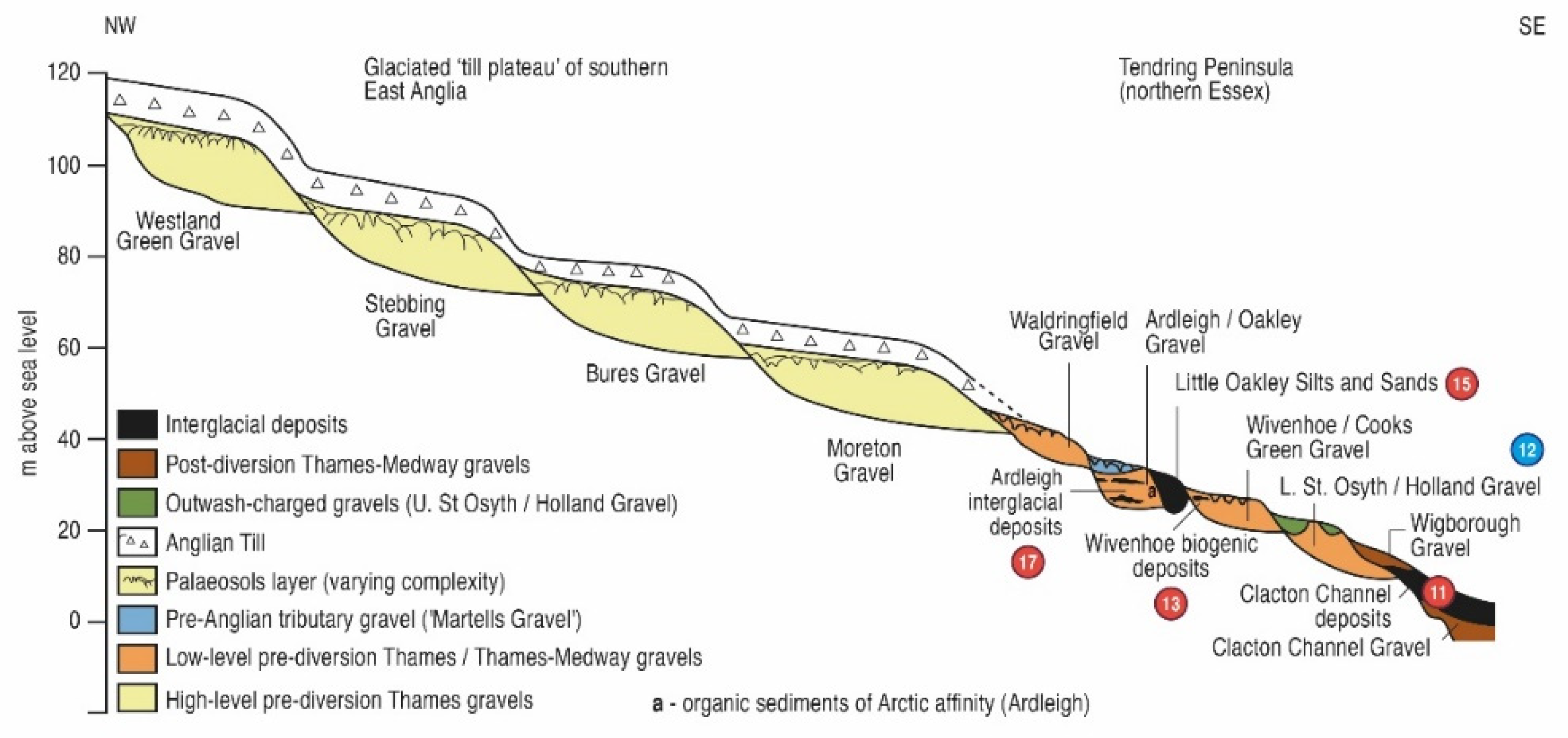
| Group | Formation | Proposed MIS | |
|---|---|---|---|
| Essex | Suffolk | ||
| Low-level East Essex Gravel | Wigborough | 1–11–10 | |
| [Part of Lowestoft Formation?] 1 | Upper St Osyth 1 | 12 | |
| KESGRAVE GROUP Low-level Kesgrave Subgroup | Lower St Osyth Wivenhoe Ardleigh Waldringfield | (Older formations offshore) Waldringfield | 12 14–13–12 18–14 >18 |
| KESGRAVE GROUP High-level Kesgrave Subgroup | Moreton Bures Stebbing Bushett Farm | Moreton Baylham Common | Lower Pleistocene |
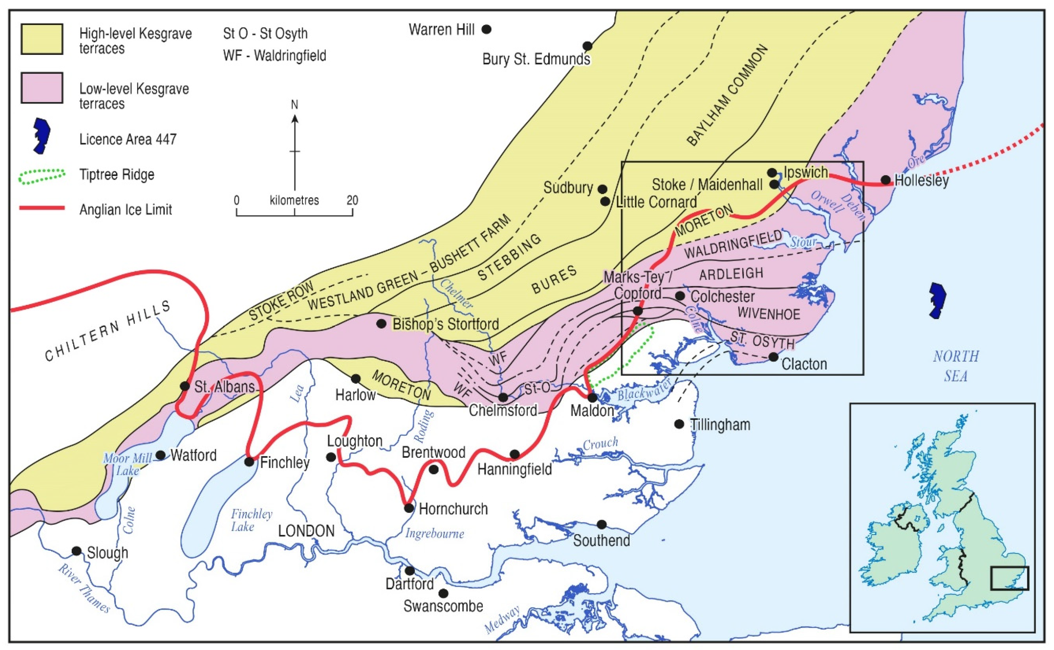
2. Geological Setting: The Tendring Peninsula and Southern Suffolk (Baseline Knowledge)
3. Materials and Methods
4. New Data: Pre-Anglian—Anglian
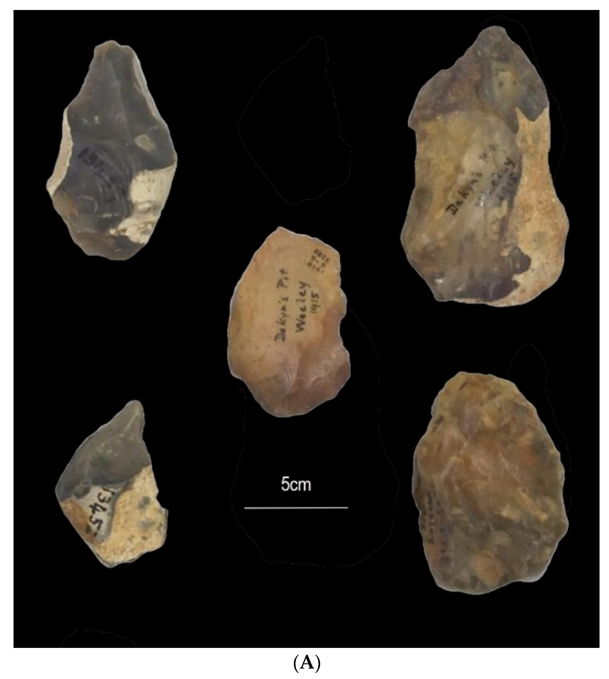
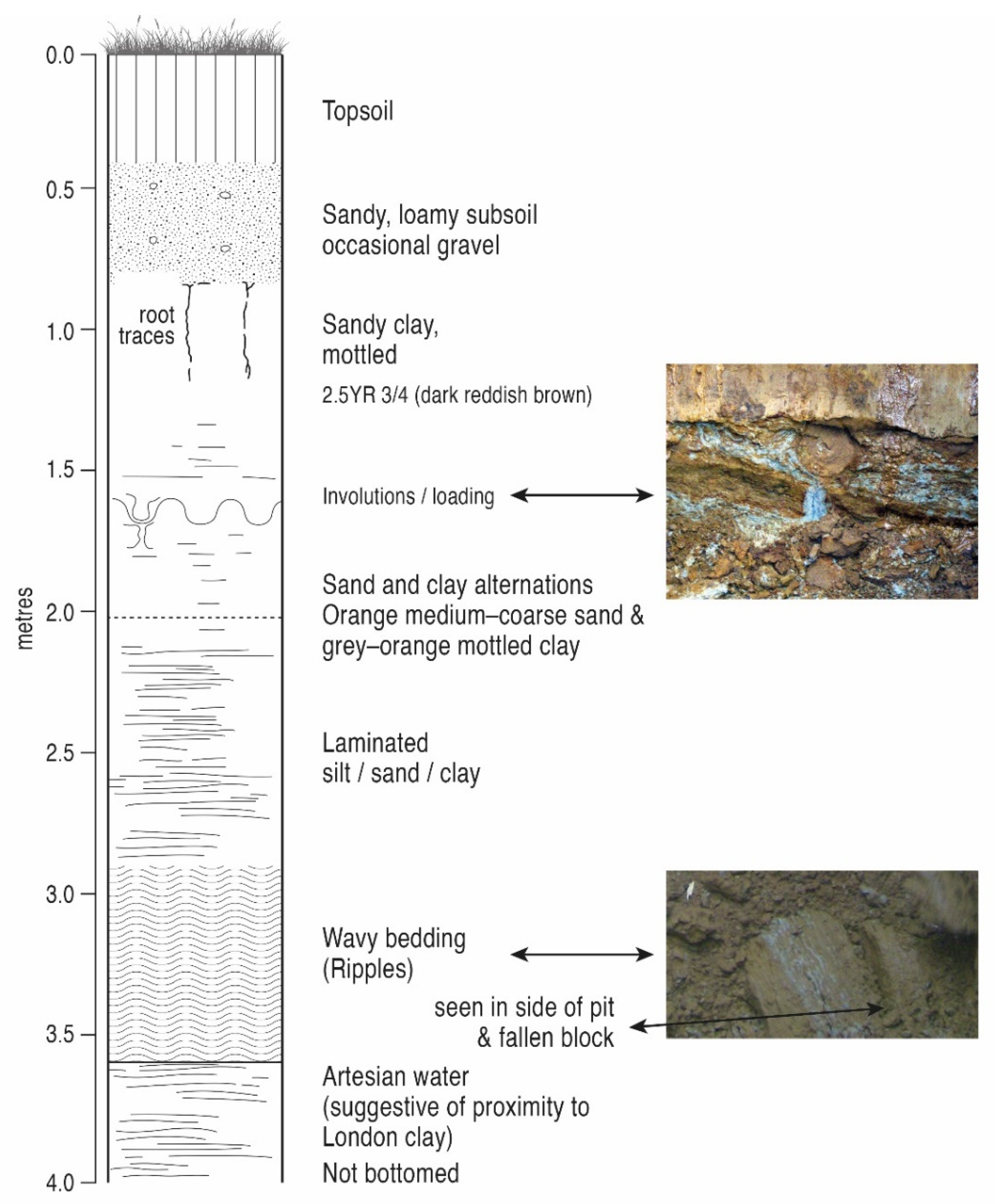
4.1. Daking’s Pit (Thorpe-le-Soken)

4.2. Verification of the Chronostratigraphical Position of the Anglian Glaciation within the Thames Terrace Archive beyond the Ice Limit
| Sample Code | Depth (cm) | 238U (Bq/kg) | 226Ra (Bq/kg) | 210Pb (Bq/kg) | 232Th (Bq/kg) | 40K (Bq/kg) | w.c. (%) | Quartz Dose Rate (Gy/ka) | K-Feldspar Dose Rate (Gy/ka) |
|---|---|---|---|---|---|---|---|---|---|
| 186401 | 200 | 3.8 ± 1.3 | 8.1 ± 0.2 | 10 ± 2 | 11.1 ± 0.2 | 117 ± 3 | 32 | 0.67 ± 0.02 | 1.61 ± 0.07 |
5. New Data: Early Post-Anglian
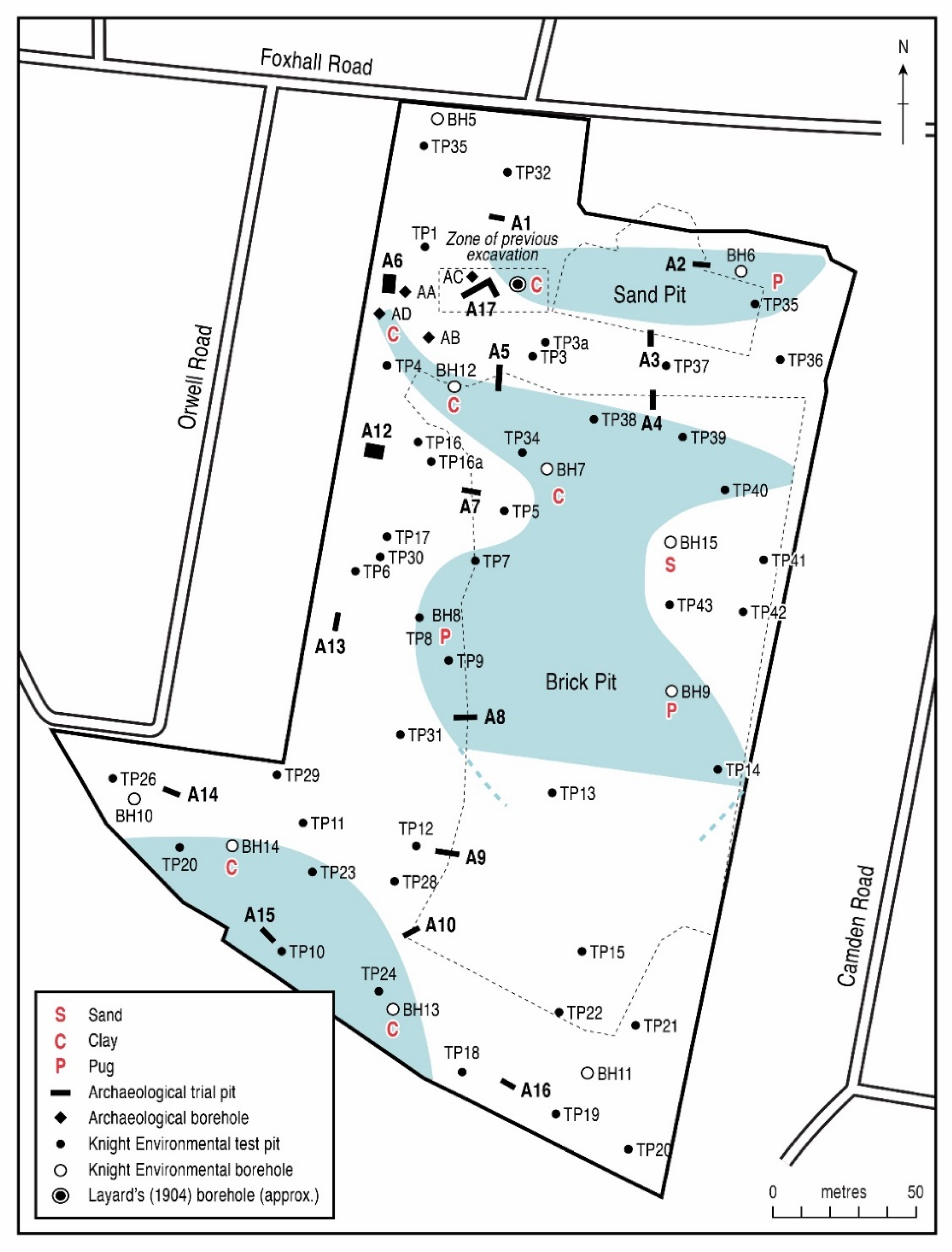
5.1. Foxhall Road, Ipswich
5.2. Spring Meadow School, Upper Dovercourt
5.3. The Clacton Channel Deposits
5.3.1. Trafalgar Road
5.3.2. Nelson Rd: Victory Court
5.3.3. Nelson Rd: Nelson’s Place
6. New Data: Later Post-Anglian
6.1. Offshore Late Middle Pleistocene Sediments with Fossils and Artefacts
6.2. Stoke Tunnel–Maidenhall (Stoke Bone Bed), Ipswich
6.3. Wrabness and Stutton Ness—Harkstead
6.4. Clacton-on-Sea Channel iii–iv
7. New Data: Last Climate Cycle
7.1. Upper Palaeolithlic Material from the Holland Brook Valley at Thorpe-le-Soken
7.2. Holocene Sediments in the Colne Estuary: Lotus Way and Jaywick Market
8. Discussion and Synthesis
8.1. Profound Quaternary Landscape and Drainage Changes over the Last ~10 Climate Cycles
8.2. The Inter-Related Palaeolithic Record
8.3. Differences between the Glaciated and Non-Glaciated Areas
8.4. The Value of Developer Funding and of Work by Learned Societies and Citizen Scientists
9. Conclusions
- (1)
- The confirmation of the Anglian age of the glacial blockage of the Thames, as demonstrated by the OSL dating of the Upper Holland Gravel;
- (2)
- The suggestion, based on artefact typology, that the Daking’s Pit hand-axe assemblage might be pre-Anglian, and therefore indigenous to the Cooks Green Gravel;
- (3)
- The discovery, from the monitoring of beach recharge, of new sources of Middle Palaeolithic archaeology, probably MIS 7 deposits exposed offshore;
- (4)
- The confirmation from AAR geochronology of the Last Interglacial (MIS 5e) age of the subsidiary Channel iii–iv at Clacton.
Supplementary Materials
Author Contributions
Funding
Acknowledgments
Conflicts of Interest
References
- Bowen, D.Q.; Rose, J.; McCabe, A.M.; Sutherland, D.G. Quaternary glaciations in England, Ireland, Scotland and Wales. Quat. Sci. Rev. 1986, 5, 299–340. [Google Scholar] [CrossRef]
- Bowen, D.Q. (Ed.) A Revised Correlation of Quaternary Deposits in the British Isles; Special Report No. 23; Geological Society of London: London, UK, 1999; 174p. [Google Scholar]
- Pawley, S.M.; Bailey, R.M.; Rose, J.; Moorlock, B.S.P.; Hamblin, R.J.O.; Booth, S.J.; Lee, J.R. Age limits on Middle Pleistocene glacial sediments from OSL dating, north Norfolk, UK. Quat. Sci. Rev. 2008, 27, 1363–1377. [Google Scholar] [CrossRef]
- Preece, R.C.; Parfitt, S.A.; Coope, G.R.; Penkman, K.E.H.; Ponel, P.; Whittaker, J.E. Biostratigraphic and aminostratigraphic constraints on the age of the Middle Pleistocene glacial succession in north Norfolk, UK. J. Quat. Sci. 2009, 24, 557–580. [Google Scholar] [CrossRef]
- Lee, J.; Candy, I.; Haslam, R. The Neogene and Quaternary of England: Landscape evolution, tectonics, climate change and their expression in the geological record. Proc. Geol. Assoc. 2018, 129, 452–481. [Google Scholar] [CrossRef]
- Sherlock, R.L. The superficial deposits of south Buckinghamshire and south Hertfordshire and the old course of the Thames. Proc. Geol. Assoc. 1924, 35, 1–28. [Google Scholar] [CrossRef]
- Clayton, K.M.; Brown, J.C. The glacial deposits around Hertford. Proc. Geol. Assoc. 1958, 69, 103–119. [Google Scholar] [CrossRef]
- Gibbard, P.L. Pleistocene history of the Vale of St. Albans. Philos. Trans. R. Soc. Lond. B Biol. Sci. 1977, 280, 445–483. [Google Scholar]
- Bridgland, D.R. Quaternary of the Thames; Geological Conservation Review Series; Chapman & Hall: London, UK, 1994; Volume 7, 401p. [Google Scholar]
- Bridgland, D.R.; Allen, P.; Currant, A.P.; Gibbard, P.L.; Lister, A.M.; Preece, R.C.; Robinson, J.E.; Stuart, A.J.; Sutcliffe, A.J. Report of the Geologists’ Association Field Meeting in north-east Essex, 22–24 May 1987. Proc. Geol. Assoc. 1988, 99, 315–333. [Google Scholar] [CrossRef]
- Bridgland, D.R.; Gibbard, P.L.; Preece, R.C. The geology and significance of the interglacial sediments at Little Oakley, Essex. Philos. Trans. R. Soc. Lond. B Biol. Sci. 1990, 328, 307–339. [Google Scholar]
- Whiteman, C.A.; Rose, J. Thames river sediments of the British Early and Middle Pleistocene. Quat. Sci. Rev. 1992, 11, 363–375. [Google Scholar] [CrossRef]
- Rose, J.; Whiteman, C.A.; Allen, P.; Kemp, R.A. The Kesgrave Sands and Gravels: ‘pre-glacial’ Quaternary deposits of the River Thames in East Anglia and the Thames Valley. Proc. Geol. Assoc. 1999, 110, 93–116. [Google Scholar] [CrossRef]
- Ellison, R.A.; Knox, R.O.B.; Jolley, D.W.; King, C. A revision of the lithostratigraphical classification of the early Palaeogene strata of the London Basin and East Anglia. Proc. Geol. Assoc. 1994, 105, 187–197. [Google Scholar] [CrossRef]
- BGS Mapping. Available online: https://0-digimap-edina-ac-uk.brum.beds.ac.uk/roam/map/geology (accessed on 20 May 2022).
- Balson, P.S. Neogene deposits of the UK sector of the southern North Sea. In Quaternary and Tertiary Geology of the Southern Bight, North Sea; Henriet, J.P., De Moor, G., Eds.; Belgian Ministry of Economic Affairs Geological Survey: Brussels, Belgium, 1989; pp. 89–95. [Google Scholar]
- Cameron, T.D.J.; Crosby, A.; Balson, P.S.; Jeffery, D.H.; Lott, G.K.; Bulat, J.; Harrison, D.J. The Geology of the Southern North Sea; HMSO: London, UK, 1992; 152p. [Google Scholar]
- Bridgland, D.R.; D’Olier, B. The Pleistocene Evolution of the Thames and Rhine Drainage Systems in the Southern North Sea Basin; Special Report No. 96; Geological Society of London: London, UK, 1995; pp. 27–45. [Google Scholar]
- Overeem, I.; Weltje, G.J.; Bishop-Kay, C.; Kroonenberg, S.B. The Late Cenozoic Eridanos delta system in the Southern North Sea Basin: A climate signal in sediment supply? Basin Res. 2001, 13, 293–312. [Google Scholar] [CrossRef]
- Hey, R.W. Highly quartzose gravels in the London Basin. Proc. Geol. Assoc. 1965, 76, 403–420. [Google Scholar] [CrossRef]
- Hey, R.W. Equivalents of the Westland Green Gravels in Essex and East Anglia. Proc. Geol. Assoc. 1980, 91, 279–290. [Google Scholar] [CrossRef]
- Whiteman, C.A. The palaeogeography and correlation of pre-Anglian-glaciation terraces of the River Thames in Essex and the London Basin. Proc. Geol. Assoc. 1992, 103, 37–56. [Google Scholar] [CrossRef]
- Green, C.P.; McGregor, D.F.M. Pre-Anglian gravel deposits of the River Thames and its tributaries between Goring and Cromer. Proc. Geol. Assoc. 1999, 110, 117–132. [Google Scholar] [CrossRef]
- Rose, J. Major river systems of central and southern Britain during the Early and Middle Pleistocene. Terra Nova 1994, 6, 435–443. [Google Scholar] [CrossRef]
- Westaway, R. Quaternary vertical crustal motion and drainage evolution in East Anglia and adjoining parts of southern England: Chronology of the Ingham River terrace deposits. Boreas 2009, 38, 261–284. [Google Scholar] [CrossRef]
- Moorlock, B.S.P.; Hamblin, R.J.O.; Booth, S.J.; Morigi, A.N. Geology of the Country around Lowestoft and Saxmundham; Memoir of the British Geological Survey, Sheets 176 and 191; British Geological Survey: Nottingham, UK, 2000; 114p. [Google Scholar]
- Rose, J.; Moorlock, B.S.P.; Hamblin, R.J.O. Pre-Anglian fluvial and coastal deposits in Eastern England: Lithostratigraphy and palaeoenvironments. Quat. Int. 2001, 79, 5–22. [Google Scholar] [CrossRef]
- Lee, J.; Rose, J.; Candy, I.; Barendregt, R. Sea-level changes, river activity, soil development and glaciation around the western margins of the southern North Sea Basin during the Early and early Middle Pleistocene: Evidence from Pakefield, Suffolk, UK. J. Quat. Sci. 2006, 21, 155–179. [Google Scholar] [CrossRef]
- Lee, J.R.; Woods, M.A.; Moorlock, B.S.P. (Eds.) British Regional Geology: East Anglia, 5th ed.; British Geological Survey: Nottingham, UK, 2015; 272p. [Google Scholar]
- Gibbard, P.L.; Moscariello, A.; Bailey, H.W.; Boreham, S.; Koch, C.; Lord, A.R.; Whittaker, H.E.; Whiteman, C.A. Comment: Middle Pleistocene sedimentation at Pakefield, Suffolk, England. J. Quat. Sci. 2008, 23, 85–92. [Google Scholar] [CrossRef]
- Bridgland, D.R. The Pleistocene fluvial stratigraphy and palaeogeography of Essex. Proc. Geol. Assoc. 1988, 99, 291–331. [Google Scholar] [CrossRef]
- Gibbard, P.L. Middle Pleistocene drainage in the Thames valley. Geol. Mag. 1979, 116, 35–44. [Google Scholar] [CrossRef]
- Cheshire, D.A. A contribution towards a glacial stratigraphy of the Lower Lea valley and implications for the Anglian Thames. Quat. Stud. 1981, 1, 27–69. [Google Scholar]
- Hopson, P.M. Chalk rafts in Anglian till in north Hertfordshire. Proc. Geol. Assoc. 1995, 106, 151–158. [Google Scholar] [CrossRef]
- Essex County Council. Tendring Geodiversity Characterisation Report; Essex County Council: Chelmsford, UK, 2009; 358p.
- Bridgland, D.R. The role of geomorphology in the Quaternary. In The History of the Study of Landforms or the Development of Geomorphology; Geomorphology in the Second Half of the Twentieth Century; Burt, T.P., Goudie, A.S., Viles, H.A., Eds.; Geological Society: London, UK, 2021; p. 58. [Google Scholar] [CrossRef]
- Kemp, R.A. Genesis and environmental significance of a buried Middle Pleistocene soil in eastern England. Geoderma 1987, 41, 49–77. [Google Scholar] [CrossRef]
- Bridgland, D.R. The Middle and Upper Pleistocene sequence in the Lower Thames: A record of Milankovitch climatic fluctuation and early human occupation of southern Britain. Proc. Geol. Assoc. 2006, 114, 23–48. [Google Scholar] [CrossRef]
- Fletcher, M.S.; Nicholls, R.A. A buried valley in the Orwell estuary. Q. J. Eng. Geol. 1984, 17, 283–288. [Google Scholar] [CrossRef]
- Mathers, S.J.; Zalasiewicz, J.A. A sedimentation pattern in Anglian marginal meltwater channels from Suffolk, England. Sedimentology 1986, 33, 559–573. [Google Scholar] [CrossRef]
- Mathers, S.J.; Zalasiewicz, J.A.; Wealthall, G.P. Styles of ice-marginal sedimentation: As revealed by a conductivity meter and extendable augers. In Glacial Deposits in Great Britain and Ireland; Ehlers, J., Gibbard, P.L., Rose, J., Eds.; Balkema: Rotterdam, The Netherlands, 1991; pp. 405–414. [Google Scholar]
- Mathers, S.J.; Zalasiewicz, J.A.; Gibbard, P.L.; Peglar, S.M. The Anglian–Hoxnian evolution of an ice-marginal drainage system in Suffolk, England. Proc. Geol. Assoc. 1993, 104, 109–122. [Google Scholar] [CrossRef]
- Mathers, S.J.; Smith, N.J.P. Geology of the Woodbridge and Felixstowe District-a Brief Explanation of the Geological Map. Sheet Explanation of the British Geological Survey 1:50,000 Sheets 208 and 225 Woodbridge and Felixstowe (England and Wales); British Geological Survey: Nottingham, UK, 2002; 34p. [Google Scholar]
- Allen, P.; White, M. The geology of Foxhall Road and the surrounding area. In Miss Layard Excavates: A Palaeolithic site at Foxhall Road, Ipswich, 1903–1905; White, M., Plunkett, S., Eds.; Western Academic & Specialist Press: Liverpool, UK, 2004; pp. 55–75. [Google Scholar]
- Mathers, S.J.; Woods, M.A.; Smith, N.J.P. Geology of the Ipswich District-a Brief Explanation of the Geological Map. Sheet Explanation of the British Geological Survey 1:50,000 Sheet 207 Ipswich (England and Wales); British Geological Survey: Nottingham, UK, 2007; 29p. [Google Scholar]
- Leszczynska, K. Reconstruction of the depositional palaeoenvironment of sand and gravel deposits at Stanway Quarry, Colchester and its implication for further development of the quarry, October 2008–January 2009. In Tarmac: A Collaborative Study with Cambridge University; Cambridge University Press: Cambridge, UK, 2009. [Google Scholar]
- Whiteman, C.A. Early and Middle Pleistocene stratigraphy in Central Essex, England. Unpublished Ph.D. Thesis, Birkbeck College, University of London, London, UK, 1990. [Google Scholar]
- Rose, J.; Allen, P. Middle Pleistocene stratigraphy in south-east Suffolk. J. Geol. Soc. Lond. 1977, 133, 83–102. [Google Scholar] [CrossRef]
- Rose, J.; Allen, P.; Hey, R.W. Middle Pleistocene stratigraphy in southern East Anglia. Nature 1976, 263, 492–494. [Google Scholar] [CrossRef]
- Turner, C. The Middle Pleistocene deposits at Marks Tey, Essex. Philos. Trans. R. Soc. Lond. B Biol. Sci. 1970, 257, 373–440. [Google Scholar]
- Turner, C. Marks Tey brickpit. In The Quaternary of the Lower Thames & eastern Essex. Field Guide; Bridgland, D.R., Allen, P., White, T.S., Eds.; Quaternary Research Association: London, UK, 2014; pp. 75–79. [Google Scholar]
- Candy, I.; Horne, D.J. The Hoxnian interglacial, MIS 11 and the lacustrine sequence at Marks Tey, Essex. In The Quaternary of the Lower Thames & eastern Essex. Field Guide; Bridgland, D.R., Allen, P., White, T.S., Eds.; Quaternary Research Association: London, UK, 2014; pp. 79–91. [Google Scholar]
- O’Connor, T. Managing the Essex Pleistocene. Project Report, Essex County Council, Place Services, 2015. Available online: https://historicengland.org.uk/research/results/reports/117-2015 (accessed on 20 May 2022).
- Tye, G.J.; Sherriff, J.; Candy, I.; Coxon, P.; Palmer, A.; McClymont, E.L.; Schreve, D.C. The δ18O stratigraphy of the Hoxnian lacustrine sequence at Marks Tey, Essex, UK: Implications for the climatic structure of MIS 11 in Britain. J. Quat. Sci. 2016, 31, 75–92. [Google Scholar] [CrossRef]
- March, A. Climate Variability during MIS 11 in Britain, Unpublished. Ph.D. Thesis, Queen Mary University of London, London, UK, 2020; 414p. [Google Scholar]
- Layard, N.F. A Recent Discovery of Paleolithic Implements in Ipswich. J. Anthropol. Inst. Great Br. Irel. 1903, 33, 41–43. [Google Scholar] [CrossRef]
- White, M.; Plunkett, S. Miss Layard Excavates: A Palaeolithic site at Foxhall Road, Ipswich, 1903–1905; Western Academic and Specialist Press Limited: Liverpool, UK, 2004; 196p. [Google Scholar]
- Allen, P.; Allen, P. FoxhallRoad, Ipswich, Suffolk. In Geoenvironmental and Archaeological Investigation, Trial Pit Evaluation and Borehole Evaluation; Essex County Council: Chelmsford, UK, 2007; 78p. [Google Scholar]
- Sparks, B.W.; West, R.G.; Williams, R.B.G.; Ransom, M. Hoxnian interglacial deposits near Hatfield, Herts. Proc. Geol. Assoc. 1969, 80, 243–267. [Google Scholar] [CrossRef]
- Gibbard, P.L.; Aalto, M.M. A Hoxnian interglacial site at Fishers Green, Stevenage, Hertfordshire. New Phytol. 1977, 72, 505–523. [Google Scholar] [CrossRef]
- Gibbard, P.L. Hatfield Polytechnic. In Field Guide to the Vale of St Albans; Rose, J., Gibbard, P.L., Eds.; Quaternary Research Association: London, UK, 1978; pp. 79–85. [Google Scholar]
- Candy, I.; Tye, G.; Coxon, P.; Hardiman, M.; Matthews, I.; Palmer, A. A tephra-based correlation of marine and terrestrial records of MIS 11c from Britain and the North Atlantic. J. Quat. Sci. 2021, 36, 1149–1161. [Google Scholar] [CrossRef]
- Westaway, R.; Maddy, D.; Bridgland, D. Flow in the lower continental crust as a mechanism for the Quaternary uplift of south-east England: Constraints from the Thames terrace record. Quat. Sci. Rev. 2002, 21, 559–603. [Google Scholar] [CrossRef]
- Bridgland, D.R.; Allen, P. A revised model for terrace formation and its significance for the lower Middle Pleistocene Thames terrace aggradations of north-east Essex, UK. In The Early Middle Pleistocene in Europe; Turner, C., Ed.; Balkema: Rotterdam, The Netherlands, 1996; pp. 121–134. [Google Scholar]
- Warren, S.H. Geological and prehistoric traps. Essex Nat. 1940, 27, 2–19. [Google Scholar]
- Lister, A.M.; McGlade, J.M.; Stuart, A.J. The Early Middle Pleistocene Vertebrate Fauna from Little Oakley, Essex. Philos. Trans. R. Soc. Lond. B Biol. Sci. 1990, 328, 359–385. [Google Scholar]
- Robinson, J.E. The ostracod fauna of the Middle Pleistocene interglacial deposits at Little Oakley, Essex. Philos. Trans. R. Soc. Lond. B. Biol. Sci. 1990, 328, 409–423. [Google Scholar]
- McKeown, M.C.; Samuel, M.D.A. Regional Study of the Sand and Gravel Resources of Essex and South Suffolk; British Geological Survey: Nottingham, UK, 1985. [Google Scholar]
- Parfitt, S.A.; Barendregt, R.W.; Breda, M.; Candy, I.; Collins, M.J.; Coope, G.R.; Durbidge, P.; Field, M.H.; Lee, J.R.; Lister, A.M.; et al. The earliest record of human activity in northern Europe. Nature 2005, 438, 1008–1012. [Google Scholar] [CrossRef]
- Parfitt, S.A.; Ashton, N.M.; Lewis, S.G.; Abel, R.L.; Coope, G.R.; Field, M.H.; Gale, R.; Hoare, P.G.; Larkin, N.R.; Lewis, M.D.; et al. Early Pleistocene human occupation at the edge of the boreal zone in northwest Europe. Nature 2010, 466, 229–233. [Google Scholar] [CrossRef]
- Westaway, R. A re-evaluation of the timing of the earliest reported human occupation of Britain: The age of the sediments at Happisburgh, eastern England. Proc. Geol. Assoc. 2011, 122, 383–396. [Google Scholar] [CrossRef]
- Bryant, R.H. Pollen spectra from Naze cliffs. In Clacton. Field Guide; Rose, J., Turner, C., Eds.; Quaternary Research Association: London, UK, 1973; unpaginated. [Google Scholar]
- Bowden, D.J.; Hunt, C.O.; Green, C.P. The Late Cenozoic deposits of the Naze, Walton, Essex. In The Quaternary of the Lower Reaches of the Thames. Field Guide; Bridgland, D.R., Allen, P., Haggart, B.A., Eds.; Quaternary Research Association: Durham, UK, 1995; pp. 299–309. [Google Scholar]
- Bridgland, D.R. Clast-lithological analysis of the gravel at Walton-on-the-Naze. In The Quaternary of the Lower Reaches of the Thames. Field Guide; Bridgland, D.R., Allen, P., Haggart, B.A., Eds.; Quaternary Research Association: Durham, UK, 1995; pp. 316–317. [Google Scholar]
- Bridgland, D.R. ‘Wealden rivers’ north of the Thames: A provenance study based on gravel clast analysis. Proc. Geol. Assoc. 1999, 110, 133–148. [Google Scholar] [CrossRef]
- Bridgland, D.R. The evolution of the River Medway, SE England, in the context of Quaternary palaeoclimate and the Palaeolithic occupation of NW Europe. Proc. Geol. Assoc. 2003, 114, 23–48. [Google Scholar] [CrossRef]
- Schreve, D.C.; Bridgland, D.R.; Allen, P.; Blackford, J.J.; Fazakerley, R.; Gleed-Owen, C.P.; Griffiths, H.I.; Keen, D.H.; White, M.J. Sedimentology, palaeontology and archaeology of late Middle Pleistocene River Thames terrace deposits at Purfleet, Essex, UK. Quat. Sci. Rev. 2002, 21, 1423–1464. [Google Scholar] [CrossRef]
- Hey, R.W. Provenance of far-travelled pebbles in the pre-Anglian Pleistocene of East Anglia. Proc. Geol. Assoc. 1976, 87, 69–81. [Google Scholar] [CrossRef]
- Bridgland, D.R. The rudaceous components of the gravels of eastern Essex: Their characteristics and provenance. Quat. Stud. 1986, 2, 34–43. [Google Scholar]
- Gibbard, P.L. The history of the great northwest European rivers during the past three million years. Philos. Trans. R. Soc. Lond. B. Biol. Ser. 1988, 318, 559–602. [Google Scholar]
- Gibbard, P.L. The formation of the Strait of Dover. In Island Britain: A Quaternary Perspective; Special Publication No. 96; Preece, R.C., Ed.; Geological Society of London: London, UK, 1995; pp. 15–26. [Google Scholar]
- Cohen, K.M.; Gibbard, P.L.; Weerts, H.J.T. North Sea palaeogeographical reconstructions for the last 1 Ma. Neth. J. Geosci. 2014, 93, 7–29. [Google Scholar] [CrossRef]
- Penkman, K.E.H.; Preece, R.C.; Bridgland, D.R.; Keen, D.H.; Meijer, T.; Parfitt, S.A.; White, T.S.; Collins, M.J. A chronological framework for the British Quaternary based on Bithynia opercula. Nature 2011, 476, 446–449. [Google Scholar] [CrossRef] [PubMed]
- Briant, R.M.; Kilfeather, A.A.; Parfitt, S.; Penkman, K.E.H.; Preece, R.C.; Roe, H.M.; Schwenninger, J.L.; Wenban-Smith, F.F.; Whittaker, J.E. Integrated chronological control on an archaeologically significant Pleistocene river terrace sequence: The Thames–Medway, eastern Essex, England. Proc. Geol. Assoc. 2012, 123, 87–108. [Google Scholar] [CrossRef]
- Penkman, K.E.H.; Preece, R.C.; Bridgland, D.R.; Keen, D.H.; Meijer, T.; Parfitt, S.A.; White, T.S.; Collins, M.J. An aminostratigraphy for the British Quaternary based on Bithynia opercula. Quat. Sci. Rev. 2013, 61, 111–134. [Google Scholar] [CrossRef]
- Bridgland, D.R.; White, M.J. Fluvial archives as a framework for the Lower and Middle Palaeolithic: Patterns of British artefact distribution and potential chronological implications. Boreas 2014, 43, 543–555. [Google Scholar] [CrossRef]
- Bridgland, D.R.; White, M.J. Chronological variations in handaxes: Patterns detected from fluvial archives in north-west Europe. J. Quat. Sci. 2015, 30, 623–638. [Google Scholar] [CrossRef]
- Chauhan, P.; Bridgland, D.R.; Moncel, M.-H.; Antoine, P.; Bahain, J.-J.; Briant, R.M.; Cunha, P.; Locht, J.-L.; Martins, A.; Schreve, D.; et al. Fluvial Deposits as an Archive of Early Human Activity: Progress during the 20 Years of the Fluvial Archives Group. Quat. Sci. Rev. 2017, 166, 114–149. [Google Scholar] [CrossRef]
- Warren, S.H. The Palaeolithic industries of the Clacton and Dovercourt districts. Essex Nat. 1933, 24, 29. [Google Scholar]
- Oakley, K.; Leakey, M. Report on Excavations at Jaywick Sands, Essex (1934), with some observations on the Clactonian Industry, and on the fauna and geological significance of the Clacton Channel. Proc. Prehist. Soc. 1937, 3, 217–260. [Google Scholar] [CrossRef]
- Wymer, J.J. Palaeolithic Sites of East Anglia; Geo Books: Norwich, UK, 1985; 440p. [Google Scholar]
- Wymer, J.J. Lower Palaeolithic Archaeology in Britain, as Represented by the Thames Valley; John Baker: London, UK, 1968. [Google Scholar]
- Littlewood, E. Contextualising archaeological and geological evidence to establish terrace age and formation at Daking’s Pit, Essex. Unpublished Bachelor’s Dissertation, Durham University, Durham, UK, 2020. [Google Scholar]
- Roe, D.A. British Lower and Middle Palaeolithic handaxe groups. Proc. Prehist. Soc. 1968, 34, 1–82. [Google Scholar]
- Bridgland, D.R.; White, M.J. The Farnham river terrace staircase: An optimal record of the Thames Palaeolithic. Earth Herit. 2018, 49, 51–53. [Google Scholar]
- Davis, R.J.; Ashton, N.M.; Lewis, S.G.; Hatch, M.; Hoare, P.G. The archaeology of the Bytham River: Human occupation of Britain during the early Middle Pleistocene and its European context. J. Quat. Sci. 2021, 36, 526–546. [Google Scholar] [CrossRef]
- Lewis, S.G.; Ashton, N.; Davis, R.; Hatch, M.; Hoare, P.G.; Voinchet, P.; Bahain, J.-J. A revised terrace stratigraphy and new ESR geochronology of the early Middle Pleistocene Bytham River in the Breckland of East Anglia, UK. Quat. Sci. Rev. 2021, 269, 107–113. [Google Scholar] [CrossRef]
- Murray, A.; Arnold, L.J.; Buylaert, J.-P.; Guérin, G.; Qin, J.; Singhvi, A.K.; Smedley, R.; Thomsen, K.J. Optically stimulated luminescence dating using quartz. Nat. Rev. Methods Primers 2021, 1, 72. [Google Scholar] [CrossRef]
- Murray, A.S.; Wintle, A.G. Luminescence dating of quartz using an improved single-aliquot regenerative-dose protocol. Radiation. Meas. 2000, 32, 57–73. [Google Scholar] [CrossRef]
- Murray, A.S.; Wintle, A.G. The single aliquot regenerative dose protocol: Potential for improvements in reliability. Radiat. Meas. 2003, 37, 377–381. [Google Scholar] [CrossRef]
- Buylaert, J.-P.; Jain, M.; Murray, A.S.; Thomsen, K.J.; Thiel, C.; Sohbati, R. A robust feldspar luminescence dating method for Middle and Late Pleistocene sediments. Boreas 2012, 41, 435–451. [Google Scholar] [CrossRef]
- Prescott, J.R.; Hutton, J.T. Cosmic ray contributions to dose rates for luminescence and ESR dating: Large depths and long-term time variations. Radiat. Meas. 1994, 23, 497–500. [Google Scholar] [CrossRef]
- Vandenberghe, D.; De Corte, F.; Buylaert, J.-P.; Kučera, J.; Van den haute, P. On the internal radioactivity in quartz. Radiat. Meas. 2008, 43, 771–775. [Google Scholar] [CrossRef]
- Huntley, D.J.; Baril, M.R. The K content of the K-feldspars being measured in optical dating or in thermoluminescence dating. Anc. TL 1997, 15, 11–13. [Google Scholar]
- Huntley, D.J.; Hancock, R.G.V. The Rb contents of the K-feldspar grains being measured in optical dating. Anc. TL 2001, 19, 43–46. [Google Scholar]
- Zhao, H.; Li, S.-H. Internal dose rate to K-feldspar grains from radioactive elements other than potassium. Radiat. Meas. 2005, 40, 84–93. [Google Scholar] [CrossRef]
- Jain, M.; Murray, A.S.; Bøtter-Jensen, L. Characterisation of blue-light stimulated luminescence components in different quartz samples: Implications for dose measurement. Radiat. Meas. 2003, 37, 441–449. [Google Scholar] [CrossRef]
- Murray, A.S. Developments in optically transferred luminescence and photo-transferred thermoluminescence dating: Application to a 2000-year sequence of flood deposits. Geochim. Cosmochim. Acta 1996, 60, 565–576. [Google Scholar] [CrossRef]
- Murray, A.; Marten, R.; Johnston, A.; Martin, P. Analysis for naturally occurring radionuclides at environmental concentrations by gamma spectrometry. J. Radioanal. Nucl. Chem. 1987, 115, 263–288. [Google Scholar] [CrossRef]
- Murray, A.S.; Helsted, L.M.; Autzen, M.; Jain, M.; Buylaert, J.-P. Measurement of natural radioactivity: Calibration and performance of a high-resolution gamma spectrometry facility. Radiat. Meas. 2018, 120, 215–220. [Google Scholar] [CrossRef]
- Guérin, G.; Mercier, N.; Adamiec, G. Dose-rate conversion factors: Update. Anc. Tl 2011, 29, 5–8. [Google Scholar]
- Buylaert, J.-P.; Vandenberghe, D.; Murray, A.S.; Huot, S.; De Corte, F.; Van den haute, P. Luminescence dating of old (>70 ka) Chinese loess: A comparison of single-aliquot OSL and IRSL techniques. Quat. Geochronol. 2007, 2, 9–14. [Google Scholar] [CrossRef]
- Pawley, S.M.; Toms, P.; Armitage, S.J.; Rose, J. Quartz luminescence dating of Anglian Stage (MIS 12) fluvial sediments: Comparison of SAR age estimates to the terrace chronology of the Middle Thames valley, UK. Quat. Geochronol. 2010, 5, 569–582. [Google Scholar] [CrossRef]
- Layard, N.F. Further excavations on a Palaeolithic site in Ipswich. J. Anthropol. Inst. Great Br. Irel. 1904, 34, 306–310. [Google Scholar] [CrossRef]
- Smith, R.A. Implements from plateau brickearths at Ipswich. Proc. Geol. Assoc. 1921, 32, 1–16. [Google Scholar] [CrossRef]
- Boswell, P.G.H.; Moir, J.R. The Pleistocene deposits and their contained Palaeolithic implements at Foxhall Road, Ipswich. J. Anthropol. Inst. 1923, 53, 229–263. [Google Scholar] [CrossRef]
- White, M.J.; Ashton, N.; Bridgland, D.R. Twisted handaxes in Middle Pleistocene Britain and their implications for regional-scale cultural variation and the deep history of Acheulean hominin groups. Proc. Prehist. Soc. 2019, 85, 61–81. [Google Scholar] [CrossRef]
- Schwenninger, J.-L. Luminescence Dating Report; P246 Foxhall Road, Ipswich; Research Laboratory for Archaeology and History of Art, University of Oxford: Oxford, UK, 2007; 14p. [Google Scholar]
- Underwood, W. A discovery of Pleistocene bones and flint implements in a gravel pit at Dovercourt, Essex. Proc. Prehist. Soc. East Angl. 1913, 1, 360–368. [Google Scholar] [CrossRef]
- Roe, D.A. A Gazetteer of British Lower and Middle Palaeolithic Sites; Research Report, No. 8; Council for British Archaeology: London, UK, 1968. [Google Scholar]
- Wymer, J.J. The Lower Palaeolithic Occupation of Britain; Wessex Archaeology and English Heritage: Salisbury, UK, 1999; 2 volumes. [Google Scholar]
- Warren, S.H. The Clacton (Essex) channel deposits. Quart. J. Geol. Soc. 1955, 61, 283–387. [Google Scholar] [CrossRef]
- Bridgland, D.R.; Field, M.H.; Holmes, J.A.; McNabb, J.; Preece, R.C.; Selby, I.; Wymer, J.J.; Boreham, S.; Irving, B.G.; Parfitt, S.A.; et al. Middle Pleistocene interglacial Thames-Medway deposits at Clacton-on-Sea, England: Reconsideration of the biostratigraphical and environmental context of the type Clactonian Palaeolithic industry. Quat. Sci. Rev. 1999, 18, 109–146. [Google Scholar] [CrossRef]
- Roe, H.M.; Preece, R.C. A new discovery of the Middle Pleistocene ‘Rhenish fauna’ in Essex. J. Conchol. 1995, 35, 272–273. [Google Scholar]
- Roe, H.M. Late Middle Pleistocene sea-level change in the southern North Sea: The record from eastern Essex. Quat. Int. 1999, 55, 115–128. [Google Scholar] [CrossRef]
- Roe, H.M. The late Middle Pleistocene biostratigraphy of the Thames Valley, England: New data from eastern Essex. Quat. Sci. Rev. 2001, 20, 1603–1619. [Google Scholar] [CrossRef]
- Bridgland, D.R.; Preece, R.C.; Roe, H.M.; Tipping, R.M.; Coope, G.R.; Field, M.H.; Robinson, J.E.; Schreve, D.C.; Crowe, K. Middle Pleistocene interglacial deposits at Barling, Essex, England: Evidence for a longer chronology for the Thames terrace sequence. J. Quat. Sci. 2001, 16, 813–840. [Google Scholar] [CrossRef]
- White, T.S.; Preece, R.C.; Whittaker, J.E. Molluscan and ostracod successions from Dierden’s Pit, Swanscombe: Insights into the fluvial history, sea-level record and human occupation of the Hoxnian Thames. Quat. Sci. Rev. 2013, 70, 73–90. [Google Scholar] [CrossRef]
- Horne, D.J.; Benardout, G.; Whittaker, J.E. Cyprideis torosa (Jones, 1850) in its type area and stratigraphical context: Potential for mapping the freshwater/estuarine boundaries of the Thames–Medway river system in the MIS 9 and MIS 11 interglacials. J. Micropalaeontol. 2017, 36, 127–135. [Google Scholar] [CrossRef]
- Horton, A.; Keen, D.H.; Field, M.H.; Robinson, J.E.; Coope, G.R.; Currant, A.P.; Graham, D.K.; Green, C.P.; Phillips, L.M. The Hoxnian Interglacial deposits at Woodston, Peterborough. Philos. Trans. R. Soc. Lond. B. Biol. 1992, 338, 131–164. [Google Scholar]
- Mitlehner, A.G. Palaeoenvironments of the Hoxnian Nar Valley Clay, Norfolk, England: Evidence from an integrated study of diatoms and ostracods. J. Quat. Sci. 1992, 7, 335–341. [Google Scholar] [CrossRef]
- Lord, A.R.; Robinson, J.E. Marine Ostracoda from the Quaternary Nar Valley Clay, West Norfolk. Bull. Geol. Soc. Norfolk 1978, 30, 113–118. [Google Scholar]
- Barlow, N.L.M.; Long, A.J.; Gehrels, W.R.; Saher, M.H.; Scaife, R.G.; Davies, H.J.; Penkman, K.E.H.; Bridgland, D.R.; Sparkes, A.; Smart, C.W.; et al. Relative sea-level variability during the late Middle Pleistocene: New evidence from eastern England. Quat. Sci. Rev. 2017, 173, 20–39. [Google Scholar] [CrossRef]
- Horne, D.J.; Bal, D.; Benardout, G.; Huckstepp, T.; Lewis, S.G.; March, A. Ostracods from Marks Tey: Palaeoenvironmental and palaeoclimatic implications. In The Quaternary of the Lower Thames & Eastern Essex. Field Guide; Bridgland, D.R., Allen, P., White, T.S., Eds.; Quaternary Research Association: London, UK, 2014; pp. 100–108. [Google Scholar]
- Pattison, J.; Berridge, N.G.; Allsop, J.M.; Wilkinson, I.P. Geology of the Country around Sudbury (Suffolk). Memoir for 1:50,000 Geological Sheet 206 (England and Wales); British Geological Survey: London, UK, 1993; 72p. [Google Scholar]
- Wymer, J.J.; Gladfelter, B.G.; Singer, R.; Mullenders, W.W. The industries at Hoxne and the Lower Paleolithic of Britain. In The Lower Paleolithic Site at Hoxne; Singer, R., Gladfelter, B.G., Wymer, J.J., Eds.; University of Chicago Press: London, UK, 1993; pp. 218–224. [Google Scholar]
- West, R.G. The Quaternary deposits at Hoxne, Suffolk. Philos. Trans. R. Soc. Lond. B Biol. Sci. 1956, 239, 265–356. [Google Scholar]
- West, R.G. Problems of the British Quaternary. Proc. Geol. Assoc. 1963, 74, 147–186. [Google Scholar] [CrossRef]
- Turner, C.; Kerney, M.P. The age of the freshwater beds of the Clacton channel. J. Geol. Soc. Lond. 1971, 127, 87–93. [Google Scholar]
- Turner, C. Eastern England. In A Correlation of Quaternary Deposits in the British Isles; Special Report No. 4; Mitchell, G.F., Penny, L.F., Shotton, F.W., West, R.G., Eds.; Geological Society of London: London, UK, 1973; pp. 8–18. [Google Scholar]
- Pike, K.; Godwin, H. The interglacial at Clacton-on-Sea. Quart. J. Geol. Soc. 1953, 108, 11–22. [Google Scholar]
- Horne, D.J. A Mutual Temperature Range method for Quaternary palaeoclimatic analysis using European nonmarine Ostracoda. Quat. Sci. Rev. 2007, 26, 1398–1415. [Google Scholar] [CrossRef]
- Bynoe, R. The submerged archaeology of the North Sea: Enhancing the Lower Palaeolithic record of northwest Europe. Quat. Sci. Rev. 2018, 191, 1–14. [Google Scholar] [CrossRef]
- Palaeolithic Archaeology Offshore of East Anglia by Rachel Bynoe-Europe’s Lost Frontiers-YouTube. Available online: https://www.youtube.com/watch?v=rCldVJ5lIhU (accessed on 20 May 2022).
- Tizzard, L.; Bicket, A.R.; Benjamin, J.; De Loecker, D. A Middle Palaeolithic site in the southern North Sea: Investigating the archaeology and palaeogeography of Area 240. J. Quat. Sci. 2014, 29, 698–710. [Google Scholar] [CrossRef]
- Layard, N.F. Animal remains from the railway cutting at Ipswich. Proc. Suffolk Inst. Archaeol. 1912, 14, 59–68. [Google Scholar]
- Layard, N.F. The Stoke Bone-bed, Ipswich. Proc. Prehist. Soc. East Angl. 1920, 3, 210–219. [Google Scholar] [CrossRef]
- Schreve, D.C. Differentiation of the British late Middle Pleistocene interglacials: The evidence from mammalian biostratigraphy. Quat. Sci. Rev. 2001, 20, 1693–1705. [Google Scholar] [CrossRef]
- White, M.; Scott, R.; Ashton, N. The Early Middle Palaeolithic in Britain: Archaeology, settlement history and human behaviour. J. Quat. Sci. 2006, 21, 525–542. [Google Scholar] [CrossRef]
- Scott, R. Becoming Neanderthals: The Earlier British Middle Palaeolithic; Oxbow Books: Oxford, UK, 2010; 243p. [Google Scholar]
- Essex County Council. Combined Sewerage Overflow Works, Maidenhall, Ipswich, Suffolk; Archaeological Evaluation and Watching Brief; Field Archaeology Report; Essex County Council: Chelmsford, UK, 2003; 24p.
- George, W.H. Geological Guide to Wrabness, Essex; Private Publication by the Author; 2010. [Google Scholar]
- Meijer, T.; Preece, R.C. A review of the occurrence of Corbicula in the Pleistocene of North-West Europe. Geol. En Mijnb./Neth. J. Geosci. 2000, 79, 241–255. [Google Scholar] [CrossRef]
- Pettitt, P.; White, M. The British Palaeolithic: Hominin Societies at the Edge of the Pleistocene World; Routledge: London, UK, 2012. [Google Scholar]
- Meijer, T.; Preece, R.C. Malacological Evidence Relating to the Insularity of the British Isles during the Quaternary; Special Report No. 96; Geological Society of London: London, UK, 1995; pp. 89–110. [Google Scholar]
- Preece, R.C. Mollusca from interglacial sediments at three critical sites in the Lower Thames. In The Quaternary of the Lower Reaches of the Thames. Field Guide; Bridgland, D.R., Allen, P., Haggart, B.A., Eds.; Quaternary Research Association: Durham, UK, 1995; pp. 53–60. [Google Scholar]
- Martingell, H.; Bain, D.R. Late Upper Palaeolithic Material from two Essex sites. Essex Archaeol. Hist. 2017, 8, 147–149. [Google Scholar]
- Hibbert, J. Holocene Sea Level Change at Clacton on Sea, Essex Coast. Unpublished Bachelor’s Dissertation, University of Greenwich, London, UK, 2020; 49p. [Google Scholar]
- Kerney, M.P.; Preece, R.C.; Turner, C. Molluscan and plant biostratigraphy of some late Devensian and Flandrian deposits in Kent. Philos. Trans. R. Soc. Lond. B Biol Sci. 1980, 291, 1–43. [Google Scholar]
- D’Olier, B. Some aspects of the late Pleistocene-Holocene drainage of the River Thames in the Eastern part of the London Basin. Philos. Trans. R. Soc. Lond. A Math. Phys. Eng. Sci. 1975, 279, 269–277. [Google Scholar]
- Roe, H.M.; Coope, G.R.; Devoy, R.J.N.; Harrison, C.J.O.; Penkman, K.E.H.; Preece, R.C.; Schreve, D.C. Differentiation of MIS 9 and MIS 11 in the continental record: Vegetational, faunal, aminostratigraphic and sea level evidence from coastal sites in Essex, UK. Quat. Sci. Rev. 2009, 28, 2342–2373. [Google Scholar] [CrossRef] [PubMed]
- Roe, H.M.; Preece, R.C. Incised palaeo-channels of the late Middle Pleistocene Thames: Age, origins and implications for fluvial palaeogeography and sea-level reconstruction in the southern North Sea basin. Quat. Sci. Rev. 2011, 30, 2498–2519. [Google Scholar] [CrossRef]
- Horne, D.J. Interglacial palaeotemperature reconstructions for MIS 11 and MIS 9 in SE England. In The Quaternary of the Lower Thames & Eastern Essex. Field Guide; Bridgland, D.R., Allen, P., White, T.S., Eds.; Quaternary Research Association: London, UK, 2014; pp. 23–27. [Google Scholar]
- Lewis, S.G.; Ashton, N.; Field, M.H.; Hoare, P.G.; Kamermans, H.; Knul, M.; Mücher, H.J.; Parfitt, S.A.; Roebroeks, W.; Sier, M.J. Human occupation of northern Europe in MIS 13: Happisburgh Site 1 (Norfolk, UK) and its European context. Quat. Sci. Rev. 2019, 211, 34–58. [Google Scholar] [CrossRef]
- Mangerud, J. The Last Interglacial/Glacial cycle in northern Europe. In Quaternary Landscapes; Shane, L.C.K., Cushing, E.J., Eds.; Bellhaven Press: London, UK, 1991; pp. 38–75. [Google Scholar]
- Coxon, P. The geomorphological history of the Waveney valley and the interglacial deposits at Hoxne. In The Lower Paleolithic Site at Hoxne; Singer, R., Gladfelter, B.G., Wymer, J.J., Eds.; University of Chicago Press: London, UK, 1993; pp. 67–73. [Google Scholar]
- Church, M.; Ryder, J.M. Paraglacial sedimentation: A consideration of fluvial processes conditioned by glaciation. Geol. Soc. Am. Bull. 1972, 83, 3059–3071. [Google Scholar] [CrossRef]
- Ballantyne, C.K. Paraglacial geomorphology. Quat. Sci. Rev. 2002, 21, 1935–2017. [Google Scholar] [CrossRef]
- Macklin, M.G.; Lewin, J. Terraced fills of Pleistocene and Holocene age in the Rheidol Valley, Wales. J. Quat. Sci. 1986, 1, 21–34. [Google Scholar] [CrossRef]
- Lewin, J.; Macklin, M.G.; Johnstone, E. Interpreting alluvial archives: Sedimentological factors in the British Holocene fluvial record. Quat. Sci. Rev. 2005, 24, 1873–1889. [Google Scholar] [CrossRef]
- Last, J.; Brown, E.J.; Bridgland, D.R.; Harding, P. Quaternary geoconservation and Palaeolithic heritage protection in the 21st century: Developing a collaborative approach. Proc. Geol. Assoc. 2013, 124, 625–637. [Google Scholar] [CrossRef]
- Irwin, A. No PhDs needed: How citizen science is transforming research. Nature 2018, 562, 480–482. [Google Scholar] [CrossRef] [PubMed]
- Bonney, R.; Cooper, C.B.; Dickinson, J.; Kelling, S.; Phillips, T.; Rosenberg, K.V.; Shirk, J. Citizen Science: A developing tool for expanding science knowledge and scientific literacy. Bioscience 2009, 59, 977–984. [Google Scholar] [CrossRef]
- Prosser, C.; Murphy, M.; Larwood, J. Geological Conservation: A Guide to Good Practice; English Nature: Peterborough, UK, 2006; 145p, Available online: http://publications.naturalengland.org.uk/publication/83048 (accessed on 20 May 2022).
- Prosser, C.D. Our rich and varied geoconservation portfolio: The foundation for the future. Proc. Geol. Assoc. 2013, 124, 568–580. [Google Scholar] [CrossRef]
- Prosser, C.D.; Brown, E.J.; Larwood, J.G.; Bridgland, D.R. Geoconservation for science and society—An agenda for the future. Proc. Geol. Assoc. 2013, 124, 561–567. [Google Scholar] [CrossRef]
- Brown, E.J. Geoconservation and geodiversity of Quaternary fluvial sites. In The Quaternary Fluvial Archives of the Major English Rivers; Field Guide; Bridgland, D.R., Briant, R.M., Allen, P., Brown, E.J., White, T.S., Eds.; Quaternary Research Association: London, UK, 2019; pp. 37–44. [Google Scholar]
- George, W.H. Field Guide to the Harwich Formation and Pleistocene deposits of Harkstead, Suffolk; A Celebration of Suffolk Geology; GeoSuffolk: Ipswich, UK, 2012; pp. 133–148. [Google Scholar]
- George, W.H. A geological field guide to Harkstead, Suffolk. Trans. Suffolk Nat. Soc. 2020, 56, 191–208. [Google Scholar]
- George, W.H. A geological field guide to Walton-on-the-Naze and Frinton. Essex Nat. 2021, 38, 8–49. [Google Scholar]
- George, W.H. A geological field guide to Stutton, Suffolk. Trans. Suffolk Nat. Soc. 2021, 57, 1–24. [Google Scholar]
- Mercer, I.; Mercer, R. Essex Rock: Geology Beneath the Landscape; Pelagic Publishing: London, UK, 2022; 416p. [Google Scholar]
- Ratford, J. Ancient hands, ancient voices: Neanderthal stone tools on Clacton beach. Essex Field Club Newsl. 2022, 97, 10–17. [Google Scholar]


| Sample Code | Sample | IR50 De, Gy | (n) | pIRIR290 De, Gy | (n) | OSL De, Gy | (n) | Uncorr. IR50 Age, ka | Uncorr. pIRIR290 Age, ka | OSL Age, ka |
|---|---|---|---|---|---|---|---|---|---|---|
| 186401 | OSL 1 Upper Gravel | 298 ± 14 | 18 | 662 ± 26 | 18 | 252 ± 17 | 36 | 186 ± 12 | 412 ± 25 | 375 ± 29 |
| Layard (see [56]) | Smith (1921) | Boswell & Moir (1923) |
|---|---|---|
| Topsoil | ||
| Upper sand and gravel | Sand | Bed 2 (fine reddish gravel) |
| Gravelly clay | Reddish and dove pug | Bed 3 (stony reddish sandy clay: pug) |
| Red and grey clay (white sandy clay) | Stiff grey clay (brickearth) | Bed 4 (laminated dove brickearth) |
| Red band a | Bed 5 (blue brickearth) | |
| Red & dove pug (brickearth) | Bed 6 (sandy brickearth) | |
| White gravelly clay | ||
| Red gravel | Red band b | Bed 7 (gravelly sandy loam) |
| Grey clay | Pure grey clay | Bed 8 (sandy loam) |
| (? Dark band) | Red band c | |
| Bone bed (various sand & gravel) | Sand, shingle, gravel | ? Beds 9–12 (various sands, gravels, clays) |
| Valvata piscinalis |
| Valvata cristata |
| Ecrobia ventrosa |
| Belgrandia marginata |
| Bithynia tentaculata |
| Bithynia troschelii |
| Lymnaea stagnalis |
| Radix balthica (=Lymnaea peregra) |
| Hippeutis complanatus |
| Gyraulus albus |
| Segmentina nitida |
| Anisus vorticulus |
| Acroloxus lacustris |
| Carychium minimum |
| Succinea sp. |
| Truncatellina sp. |
| Vallonia excentrica |
| Vallonia costata |
| Aegopinella nitidula |
| Zonitoides excavatus 1 |
| Zonitoides nitidus |
| Discus rotundatus |
| Clausilia (including pumila) |
| Trochulus sp. |
| Cepaea sp. |
| Carychium minimum |
| Limax sp. |
| Unionids/Potomida littoralis 2 |
| Sphaerium corneum |
| Pisidium nitidum |
| Pisidium clessini |
| Pisidium amnicum |
| Pisidium moitessierianum |
| Pisidium henslowanum sp. |
Publisher’s Note: MDPI stays neutral with regard to jurisdictional claims in published maps and institutional affiliations. |
© 2022 by the authors. Licensee MDPI, Basel, Switzerland. This article is an open access article distributed under the terms and conditions of the Creative Commons Attribution (CC BY) license (https://creativecommons.org/licenses/by/4.0/).
Share and Cite
Allen, P.; Bain, D.R.; Bridgland, D.R.; Buisson, P.; Buylaert, J.-P.; Bynoe, R.; George, W.H.; Haggart, B.A.; Horne, D.J.; Littlewood, E.-M.; et al. Mid-Late Quaternary Fluvial Archives near the Margin of the MIS 12 Glaciation in Southern East Anglia, UK: Amalgamation of Multi-Disciplinary and Citizen-Science Data Sources. Quaternary 2022, 5, 37. https://0-doi-org.brum.beds.ac.uk/10.3390/quat5030037
Allen P, Bain DR, Bridgland DR, Buisson P, Buylaert J-P, Bynoe R, George WH, Haggart BA, Horne DJ, Littlewood E-M, et al. Mid-Late Quaternary Fluvial Archives near the Margin of the MIS 12 Glaciation in Southern East Anglia, UK: Amalgamation of Multi-Disciplinary and Citizen-Science Data Sources. Quaternary. 2022; 5(3):37. https://0-doi-org.brum.beds.ac.uk/10.3390/quat5030037
Chicago/Turabian StyleAllen, Peter, David R. Bain, David R. Bridgland, Paul Buisson, Jan-Pieter Buylaert, Rachel Bynoe, William H. George, B. Andrew Haggart, David J. Horne, Ellen-May Littlewood, and et al. 2022. "Mid-Late Quaternary Fluvial Archives near the Margin of the MIS 12 Glaciation in Southern East Anglia, UK: Amalgamation of Multi-Disciplinary and Citizen-Science Data Sources" Quaternary 5, no. 3: 37. https://0-doi-org.brum.beds.ac.uk/10.3390/quat5030037